Educación e integración social: barreras visibles e invisibles
Upload
nguyenthienCategory
view
213download
1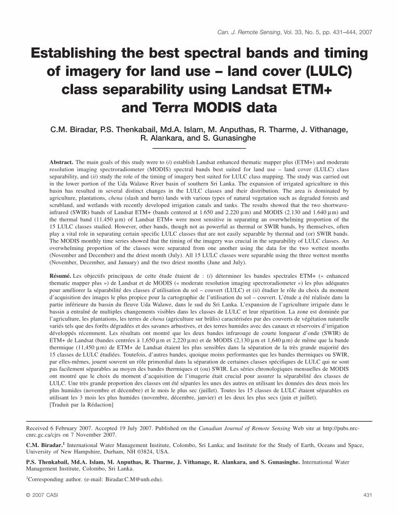
Establishing the best spectral bands and timingof imagery for land use – land cover (LULC)
class separability using Landsat ETM+and Terra MODIS data
C.M. Biradar, P.S. Thenkabail, Md.A. Islam, M. Anputhas, R. Tharme, J. Vithanage,R. Alankara, and S. Gunasinghe
Abstract. The main goals of this study were to (i) establish Landsat enhanced thematic mapper plus (ETM+) and moderateresolution imaging spectroradiometer (MODIS) spectral bands best suited for land use – land cover (LULC) classseparability, and (ii) study the role of the timing of imagery best suited for LULC class mapping. The study was carried outin the lower portion of the Uda Walawe River basin of southern Sri Lanka. The expansion of irrigated agriculture in thisbasin has resulted in several distinct changes in the LULC classes and their distribution. The area is dominated byagriculture, plantations, chena (slash and burn) lands with various types of natural vegetation such as degraded forests andscrubland, and wetlands with recently developed irrigation canals and tanks. The results showed that the two shortwave-infrared (SWIR) bands of Landsat ETM+ (bands centered at 1.650 and 2.220 µm) and MODIS (2.130 and 1.640 µm) andthe thermal band (11.450 µm) of Landsat ETM+ were most sensitive in separating an overwhelming proportion of the15 LULC classes studied. However, other bands, though not as powerful as thermal or SWIR bands, by themselves, oftenplay a vital role in separating certain specific LULC classes that are not easily separable by thermal and (or) SWIR bands.The MODIS monthly time series showed that the timing of the imagery was crucial in the separability of LULC classes. Anoverwhelming proportion of the classes were separated from one another using the data for the two wettest months(November and December) and the driest month (July). All 15 LULC classes were separable using the three wettest months(November, December, and January) and the two driest months (June and July).
Biradar et al.444Résumé. Les objectifs principaux de cette étude étaient de : (i) déterminer les bandes spectrales ETM+ (« enhancedthematic mapper plus ») de Landsat et de MODIS (« moderate resolution imaging spectroradiometer ») les plus adéquatespour améliorer la séparabilité des classes d’utilisation du sol – couvert (LULC) et (ii) étudier le rôle du choix du momentd’acquisition des images le plus propice pour la cartographie de l’utilisation du sol – couvert. L’étude a été réalisée dans lapartie inférieure du bassin du fleuve Uda Walawe, dans le sud du Sri Lanka. L’expansion de l’agriculture irriguée dans lebassin a entraîné de multiples changements visibles dans les classes de LULC et leur répartition. La zone est dominée parl’agriculture, les plantations, les terres de chena (agriculture sur brûlis) caractérisées par des couverts de végétation naturellevariés tels que des forêts dégradées et des savanes arbustives, et des terres humides avec des canaux et réservoirs d’irrigationdéveloppés récemment. Les résultats ont montré que les deux bandes infrarouge de courte longueur d’onde (SWIR) deETM+ de Landsat (bandes centrées à 1,650 µm et 2,220 µm) et de MODIS (2,130 µm et 1,640 µm) de même que la bandethermique (11,450 µm) de ETM+ de Landsat étaient les plus sensibles dans la séparation de la très grande majorité des15 classes de LULC étudiées. Toutefois, d’autres bandes, quoique moins performantes que les bandes thermiques ou SWIR,par elles-mêmes, jouent souvent un rôle primordial dans la séparation de certaines classes spécifiques de LULC qui ne sontpas facilement séparables au moyen des bandes thermiques et (ou) SWIR. Les séries chronologiques mensuelles de MODISont montré que le choix du moment d’acquisition de l’imagerie était crucial pour assurer la séparabilité des classes deLULC. Une très grande proportion des classes ont été séparées les unes des autres en utilisant les données des deux mois lesplus humides (novembre et décembre) et le mois le plus sec (juillet). Toutes les 15 classes de LULC étaient séparables enutilisant les 3 mois les plus humides (novembre, décembre, janvier) et les deux les plus secs (juin et juillet).[Traduit par la Rédaction]
© 2007 CASI 431
Can. J. Remote Sensing, Vol. 33, No. 5, pp. 431–444, 2007
Received 6 February 2007. Accepted 19 July 2007. Published on the Canadian Journal of Remote Sensing Web site at http://pubs.nrc-cnrc.gc.ca/cjrs on 7 November 2007.
C.M. Biradar.1 International Water Management Institute, Colombo, Sri Lanka; and Institute for the Study of Earth, Oceans and Space,University of New Hampshire, Durham, NH 03824, USA.
P.S. Thenkabail, Md.A. Islam, M. Anputhas, R. Tharme, J. Vithanage, R. Alankara, and S. Gunasinghe. International WaterManagement Institute, Colombo, Sri Lanka.
1Corresponding author. (e-mail: [email protected]).

Background and rationaleThe effects of land cover conversion with significant changes
can affect hydrological (Williams and Melack, 1997) andbiological processes (Holscher et al., 1997). Monitoring thelocations and distributions of land cover changes is importantfor establishing linkages between policy decisions, regulatoryactions, and subsequent land-use activities (Jones et al., 1997;Biradar et al., 2004; Lunetta et al., 2006). Numerous techniqueshave been demonstrated for thematic change analysis usingremote sensing data (Singh, 1989; Coppin and Bauer, 1996;Jensen, 1996), and these might be applicable for changedetection (Singh, 1989; Stow et al., 1996) and allow theidentification of major processes of change and, by inference,the characterization of land-use dynamics (Lambin andEhrlich, 1997; Mertensl and Lambin, 1999; Biradar et al.,2003). Land cover composition and change are importantfactors that affect ecosystem conditions and functions. The useof satellite-based remote sensor data has been widely applied toprovide a cost-effective means to develop land cover over largegeographic regions (Lunetta et al., 2006).
To date, most research studies have recognized and used theentire set of bands in a sensor for land use – land cover (LULC)studies. However, there is limited information available tounderstand which Landsat enhanced thematic mapper plus(ETM+) spectral bands and moderate-resolution imagingspectroradiometer (MODIS) time-series months are best suited forLULC mapping, and whether there is a need to use each and everyband and (or) month. Identification of optimal bands and monthsfor mapping and characterization of LULC classes, by droppingredundant bands–months, is the most effective course of action.Also, the satellite sensor data at various time periods can never beguaranteed from any one sensor, given the availability of cloud-free images in humid tropical regions. The combination of sensortypes and time series provides a better option to overcome thelimitation of the data gap due to cloud cover, reduces datavolumes, and provides optimal data for processing.
This research was conducted at the Uda Walawe left bankirrigation extension project in Sri Lanka. The expansion ofirrigated agriculture in the Uda Walawe area has resulted inseveral distinct changes in the LULC classes and theirdistribution. An important component of the local biodiversityconservation and management was the delineation and mappingof LULC classes for preservation and restoration (Biradar et al.,2003; Garono et al., 2003). Developmental activities such as landclearing and expansion of irrigated agriculture have dramaticallyaltered both distribution and conditions of the original LULCclasses in the region. The influence of irrigated agriculture in theUda Walawe left bank extension area can be observed almosteverywhere. More than half of the landscape of Uda Walawe hasbeen cleared for irrigated agriculture, resulting in a number ofdistinct LULC classes.
The primary objective of this research was to establish the bestspectral bands from Landsat ETM+ and MODIS images formapping distinct LULC classes. The secondary objective was todetermine the optimum timing of MODIS data acquisition.
Irrigation projects in the study area started at the end of 2001 andbecame operational at the end of 2003. The LULC classseparability analysis and mapping were done prior to and aftercommissioning of the irrigation projects based on 2001 and 2003Landsat ETM+ images. Similarly, coarse-resolution MODIS500 m 8-day surface reflectance time series from 2002 to 2003were used to study the optimum bands, and the same data wereused to generate monthly maximum value composites (MVCs)using a time series normalized difference vegetation index(NDVI) to determine the best months for LULC class separability.
MethodsStudy area
The study area lies in the lower portion of the Uda WalaweRiver basin of southern Sri Lanka at an elevation ranging fromover 90 m to sea level on the southern coast (Figure 1).Precipitation varies significantly in the basin from over 3000 mmin the northern tip to around 1000 mm along the seashore. Theaverage temperature in the area is about 28 °C (Shortt, 2001). Thearea is dominated by agriculture and includes plantations (bananaand coconut), forestation, and chena land. Irrigation is practised inthe fragmented areas through diversion of small streams in thehighlands and by small tanks and reservoirs in the plains (Molle etal., 2003). The construction of the left bank irrigation system hasenabled farmers to cultivate during both the main cropping seasoncalled maha, from October to February, and the secondarycropping season called yala, from April to August. The irrigatedfields serve mainly for cultivation of cash crops. The main cropgrown is rice, with sugarcane in fragmented patches. In the homegardens – croplands with orchards, fruits and vegetables are grownfor consumption by the farmers themselves.
Data
Satellite remote sensing dataThe study used coarse-resolution MODIS surface reflectance
8-day level 3 at 500 m pixel resolution images (MOD09A1,version 3) for the period 2001–2003 and medium-resolutionLandsat ETM+ satellite images, whose characteristics are listedin Table 1. Landsat ETM+ at 30 m pixel resolution images for14 March 2001 (before the irrigation project) and 5 April 2003(after the irrigation project) were used for classification andspectral band separability analysis. The anomalies associatedwith MODIS data, such as atmospheric effects and clouds,were eliminated in the level-3 8-day composites (MOD09A1,version 3), and maximum value composites were composed forfurther enhancement of the time-series images by removing anytraces of ambiguous pixels. In addition, 8-day and monthlyMODIS time series NDVI maximum value composite (MVC)value data at 500 m resolution for the years 2001–2003 wereused for time-series (phenology) analysis and spectral signatureextraction to identify the best month for separating LULC classtypes (see processing techniques in Thenkabail et al., 2005).
Secondary and ancillary data such as topographic maps,construction maps (Nippon Koei Co. Ltd., 2005), administrative
432 © 2007 CASI
Vol. 33, No. 5, October/octobre 2007
© 2007 CASI 433
Canadian Journal of Remote Sensing / Journal canadien de télédétection
Figure 1. Location map of the study area, showing the original plan for the layout of the irrigation scheme under theWalawe left bank irrigation upgrading and extension project (source: Nippon Koei Co. Ltd., 2005).

boundaries, meteorological data, soil types, and agro-ecologicalzones from the International Water Management Institute(IWMI) Data Storehouse Pathway (International WaterManagement Institute, 2004) were used to aid the LULC classidentification and labeling process.
Ground-truth dataGround-truth data were collected from the field campaign
from 3 to 7 May 2004. Ground-truth data from the previousfield campaigns (see www.iwmidsp.org) by IWMIresearchers were also used to extract information for theyears 2001 and 2003. The overall sample size of ground-truth data for the 15 key LULC classes in the study area isshown in Table 2. During ground-truthing, information wascollected on LULC class conditions, cover density formapping, and separability analysis. The ground-truth datawere organized in standard format (www.iwmidsp.org) andused in LULC class identification and labeling as per theprocedures described in Thenkabail et al. (2004; 2006).Class labels were assigned in the field using a system thatallows merging to a higher class or breakdown into adistinctly unique class in a hierarchical format, based on theland cover percentage taken at each location. The preciselocations of the global positioning system (GPS) pointsreferring each point detail were catalogued and linked in ArcView (Environmental Systems Research Institute, Inc.,2000) to ease information access (Figure 2). The datainclude latitude, longitude (in World Geodetic System 1984(WGS 84) datum), altitude, LULC class, land-cover type(percentages of trees, shrubs, grasses, etc.), canopy density,irrigation system, and digital photographs at every ground-truth location. Altogether, 300 ground-truth points werecollected using the stratified random sampling design.Similar classes and closely related classes, for example,scrubland–open, sparse, and dense, were grouped to reducethe number of LULC classes termed as aggregated LULC
classes, whose sample sizes are shown in Table 2. Theground-truth data can be downloaded free of charge at theIWMI Data Storehouse Pathway (www.iwmidsp.org).
Spectral bands for class separability
The study evaluated the optimal spectral bands for classseparability using Landsat ETM+ data and MODIS time seriesas described in the following subsections.
Landsat ETM+ spectral bands and class separabilityThe top-of-atmosphere reflectance values of Landsat ETM+
data for the 15 LULC classes for years 2001 (before irrigationproject) and 2003 (after irrigation project) were used to test classseparability. The analysis of variance, using the generalizedlinear model, was used to perform this exercise, and the leastsquared difference of means was used to distinguish the LULC
434 © 2007 CASI
Vol. 33, No. 5, October/octobre 2007
Class No. Class nameNo. ofplots
1 Rice paddy dominant 442 Chena lands 283 Remnant degraded forest 164 Scrubland 385 Inland water bodies (deep) 166 Aquatic vegetation and croplands (mixed) 107 Home gardens – croplands with orchards 168 Wetlands (shallow water – marshy) 209 Wetlands (with aquatic vegetation) 1810 Water body (shallow) 2011 Fuelwood and multipurpose tree plantations 612 Human settlements and barren lands 2013 Roads–canals 2014 Bare land – fallow fields 2015 Low herbaceous – grass cover 8
Table 2. Land use – land cover (LULC) classes and number of90 m × 90 m ground-truth sample plots.
Spatial resolution Band used Band number Band range (µm) Band center (µm)
MODIS sensor (January 2001 to December 2003)500 m (optical) 7 Band1 0.620–0.670 0.645
7 Band2 0.840–0.876 0.8587 Band3 0.459–0.479 0.4697 Band4 0.545–0.565 0.5557 Band5 1.230–1.250 1.2407 Band6 1.628–1.652 1.6407 Band7 2.105–2.155 2.130
Landsat-7 ETM+ sensor (14 March 2001; 5 April 2003)30 m (optical) 6 Band1 0.450–0.515 0.483
6 Band2 0.525–0.605 0.5656 Band3 0.630–0.690 0.6606 Band4 0.750–0.900 0.8256 Band5 1.550–1.750 1.650
60 m (thermal) 1 Band6 10.400–12.500 11.4501 Band7 2.090–2.350 2.220
Table 1. Characteristics of satellite sensor data used in this study.

classes from one another. The statistical package SAS (version9.3) was used to perform the analysis. Significant statisticaldifferences between the LULC classes were tested at the 90%confidence level. The analysis was performed for each year(2001 and 2003) separately and for the pooled years (2001 and2003) of the Landsat ETM+. Since the pooled data gave anoutput similar to that of the single-year analysis, only the pooled-data results are reported. The best bands for separating variousLULC classes were identified based on the separability of LULCclasses by different techniques.
MODIS time series and class separabilityA analysis similar to that given in the previous section was
carried out using MODIS time series. The significance ofspectral differences between the LULC classes was tested at the
90% confidence level. The MODIS time-series results arediscussed for each time point (monthly basis). Through thiseffort, the timing of the MODIS data in separating LULCclasses was identified. The dominant bands associated with thebest months were also identified.
LULC classificationThe strategy in LULC classification was to classify and
separate the 15 distinct (Table 2) LULC classes using classidentification and labeling procedures described in Thenkabailet al. (2006; 2007) and illustrated in Figure 3A. The LandsatETM+ data (Table 1) were classified using the iterative self-organizing data analysis technique algorithm (ISODATA)through the unsupervised classification in the ERDAS Imaginesoftware package (Leica Geosystems, 2005).
© 2007 CASI 435
Canadian Journal of Remote Sensing / Journal canadien de télédétection
Figure 2. Locations of ground-truth sampling sites (numbered green squares) in relation to thestudy area (yellow border) overlaid on the Landsat ETM+ image acquired 5 April 2003. Otherfield information and photographs have been hyperlinked to each ground-truth point.

436 © 2007 CASI
Vol. 33, No. 5, October/octobre 2007
Figure 3. (A) Methodology used for mapping LULC classes. (B) Methodology used forresolving conflict (mixed) classes.

The spectral properties of classes were analyzed based ontheir distribution in brightness–greenness–wetness (BGW)tassel cap feature space and spectral curves (Thenkabail et al.,2005). Each class has been identified and labeled based on itsspectral behavior in two-dimensional (2D) and three-dimensional (3D) plotting. Classes were identified and labeledbased on the ground-truth information, high-resolution images,NDVI plots, and spectral curves (Figure 3) (Thenkabail et al.,2006). All this information was put together to perform classinterpretation. Any change that occurs, even at a single pixel,was tracked by its location in brightness, greenness, andwetness feature space (Thenkabail et al., 2005). Generally,broad LULC classes were classified using the techniquesexplained previously.
Resolving mixed classes
Some classes were locally misclassified and intermixed withneighboring classes, and such misclassified pixels werenormally identifiable using ground-truth data points wherecover types were mapped out of their normal context (Fuller etal., 1998). For example, the class chena was mixed not onlywithin scrublands as expected but also within some degraded
forest areas. Such misclassifications could be removed bycontextual correction methods (Groom et al., 1996; Thenkabailet al., 2006). Such pixels of mixed classes, referred to herein asconflict classes, were selectively filtered out using masking andreclassification of those selected segments (Figure 3B). Theconflict classes were aggregated to generate a mask file thatwas then reclassified into 10 clusters to segregate conflictpixels, thereby identifying cropland, scrubland, and a fewpixels of degraded forests (Figure 3B).
The segregated segment was then merged with the base map.This process of contextual correction was repeated for anumber of conflict classes until all classes were properlyreallocated to their likely LULC class types (Fuller et al., 1998;Thenkabail et al., 2005). Lastly, a statistical filter using a 3 × 3kernel was run to remove unwanted salt-and-pepper effects(Schowengerdt, 1983). The main reason for this process was toremove excessive noise in the thematic map while retaining thereal heterogeneity of the LULC classes (Fuller et al., 1998).The generalized, initial, disaggregated 250 subclasses weremerged to produce the aggregated 15-class LULC map(Figure 4).
© 2007 CASI 437
Canadian Journal of Remote Sensing / Journal canadien de télédétection
Figure 4. Land use – land cover map derived from Landsat ETM+ for the year 2003.

438 © 2007 CASI
Vol. 33, No. 5, October/octobre 2007
Figure 5. Spectral characteristics of the LULC classes derived from Landsat ETM+ data using ground-truth points–polygons.
Figure 6. Spectral characteristics of the LULC classes derived using ground-truth points–polygons from MODIS 8-day surface reflectance data averaged for the months of January, November, and December 2003.

Results and discussionsSpectral characteristics of the LULC classes
To develop spectral properties of the LULC classes, digitalvalues of the satellite images were extracted from seven bandsof the Landsat ETM+ data from each 3 × 3 pixel area andsignature polygon identified during ground-truthing. Thesepixels and polygons were selected by plotting the GPSinformation of the sample sites on the satellite image. The meanspectral values for each LULC class for its correspondingspectral bands were plotted (Figure 5). Additionally, the sameLULC class reflectance values also vary because of theirconditions and associations. These spectral properties of theLULC classes were plotted to identify the most sensitive bands.
The mean band reflectance value of all 15 LULC classes(Table 2) was plotted over the spectral range of the LandsatETM+ image (Figure 5). Each band shows a variablereflectance value and a corresponding curve of the LULC classproperties. Healthy vegetation, such as irrigated croplands,forests, and plantations, has the highest infrared reflectancevalues, whereas stressed and very scattered vegetation, such asscattered scrubland, fallow lands, and water, has the lowestinfrared reflectance values. The reflectivity of 15 LULC classesin various ETM+ spectral bands (Figure 5) is input into theSAS statistical package to assess and identify the most sensitivebands for LULC class separability. A similar procedure wasused to identify the most sensitive bands (Figure 6) and months(Figure 7) in separating LULC classes based on the MODIS
500 m 8-day surface reflectance (first seven bands) (seeTable 1) and monthly NDVI maximum value composites(MVCs) derived from the 8-day surface reflectance data.
Landsat ETM+ spectral bands separating LULC classes
The seven bands of the Landsat ETM+ data were used toevaluate the most desirable waveband for the LULC classseparability, and the results are shown in Table 3. It was foundthat the human settlements and barren lands class can beseparated from the rice paddy dominant class by any waveband,whereas chena lands can only be separated from the rice paddydominant class by spectral bands 5 and 6 (Table 3).
The most readily separable types of LULC classes usingLandsat ETM+ were (Table 3) bare land – fallow fields, chenalands, water body (shallow), human settlements and barrenlands, inland water bodies (deep), wetlands (with aquaticvegetation), wetlands (shallow water – marshy), and wetlands(with aquatic vegetation). Fuelwood and multipurpose treeplantations was the least separable LULC class (only separablefrom eight other LULC classes) using Landsat ETM+(Table 3). The LULC types that could not be separated fromfuelwood and multipurpose tree plantations were rice paddydominant, home gardens – croplands with orchards, remnantdegraded forest, low herbaceous – grass cover, roads–canals,and scrubland (Table 3). Thermal data (band 6) were found tobe the most desirable band in separating waterlogged ricepaddy dominant from arid chena lands due to differences insurface temperature (Table 3), and the spectral waveband 3
© 2007 CASI 439
Canadian Journal of Remote Sensing / Journal canadien de télédétection
Figure 7. Spectral reflectivity of LULC classes based on MODIS monthly MVC time series NDVI data for 2001 and2003.

(red) was the least effective band of Landsat ETM+ inseparating LULC class type. However, one cannot neglectthis band to achieve the maximum separability. For instance,the LULC class rice paddy dominant can only be separatedfrom scrubland by spectral band 3 (Table 3; Figure 8).
When the band occurrences from Table 3 are summarized,the study highlights the importance of shortwave infraredbands (ETM+ bands 5 and 7) and the thermal band (ETM+band 6) as the most important bands in LULC classseparability (see Figure 8).
440 © 2007 CASI
Vol. 33, No. 5, October/octobre 2007
Rice paddy
dominant
Bare land –
fallow fields
Fuelwood and
multipurpose tree
plantations
Home gardens –
croplands with
orchards Chena lands
Remnant
degraded forest
Low herbaceous –
grass cover
Rice paddy dominant — 1, 2, 3, 5, 6, 7 5, 6 1, 2, 3, 6, 7 1, 6
Bare land – fallow fields 1, 2, 3, 5, 6, 7 — 1, 2, 3, 5, 6, 7 1, 2, 3, 5, 6 1, 2, 3, 5, 6, 7 1, 2, 3, 5, 6, 7 1, 2, 3, 5, 6, 7
Fuelwood and multipurpose tree
plantations
1, 2, 3, 5, 6, 7 — 5, 6
Home gardens – croplands with
orchards
1, 2, 3, 5, 6 — 5, 6 3, 4, 6, 7
Chena lands 5, 6 1, 2, 3, 5, 6, 7 5, 6 5, 6 — 1, 2, 3, 5, 6, 7 1, 3, 5, 6
Remnant degraded forest 1, 2, 3, 6, 7 1, 2, 3, 5, 6, 7 3, 4, 6, 7 1, 2, 3, 5, 6, 7 —
Low herbaceous – grass cover 1, 6 1, 2, 3, 5, 6, 7 3, 4, 6, 7 —
Water body (shallow) 1, 2, 4, 5, 6, 7 3, 4, 5, 6, 7 1, 2, 4, 5, 6, 7 1, 2, 4, 5, 6, 7 1, 2, 4, 5, 6, 7 1, 2, 3, 4, 5, 6, 7 1, 2, 4, 5, 6, 7
Roads–canals 1, 2, 3, 5, 6, 7 1 5, 6 1, 2, 3, 5, 6, 7 1, 6
Scrubland 3 1, 2, 3, 5, 6, 7 3, 5, 6 2, 5, 6, 7
Human settlements and barren
lands
5 1, 2, 3, 5, 6 1 1 5, 6 1, 2, 3, 6, 7 1
Inland water bodies (deep) 1, 2, 3, 4, 5, 6, 7 1, 2, 3, 4, 5, 6, 7 1, 2, 3, 4, 5, 6, 7 1, 2, 3, 4, 5, 6, 7 1, 2, 3, 4, 5, 6, 7 1, 2, 3, 4, 5, 6, 7 1, 2, 3, 4, 5, 6, 7
Wetlands (with aquatic vegetation) 3, 4, 5, 6, 7 1, 2, 3, 4, 5, 6, 7 1, 4, 5, 6, 7 1, 4, 5, 6, 7 3, 4, 5, 6, 7 1, 4, 5, 6, 7 1, 4, 5, 6, 7
Wetlands (shallow water – marshy) 1, 2, 4, 5, 6, 7 3, 4, 5, 6, 7 1, 2, 4, 5, 6, 7 1, 2, 4, 5, 6, 7 1, 2, 4, 5, 6, 7 1, 2, 3, 4, 5, 6, 7 1, 2, 3, 4, 5, 6, 7
Aquatic vegetation and croplands
(mixed)
3, 4, 5, 6, 7 1, 2, 3, 5, 6, 7 5, 6 1, 4, 5, 6, 7 3, 4, 5, 6, 7 1, 2, 5, 6 1, 5, 6
Habitat separability from all
other habitats
11/14 14/14a 8/14b 10/14 14/14a 12/14 10/14
Note: The band numbers in each entry within the matrix denote separability between habitat classes. For example, the entry “1, 2, 3, 5, 6, 7” for bare land – fallow field versusrice paddy dominant indicate that the two classes can be separated by Landsat ETM+ bands 1, 2, 3, 5, 6, or 7.
aMost separable classes using Landsat ETM+ data. Bare land – fallow fields, chena lands, water body (shallow), human settlements and barren lands, inland water bodies (deep),water body (shallow), wetlands (with aquatic vegetation), and wetlands (shallow water – marshy)) can be separated from all other habitats by one or more ETM+ bands at the 90%confidence level or higher.
bLeast separable LULC classes from Landsat ETM+ data. Fuelwood and multipurpose tree plantations can only be separated from eight other habitats (least separable) at the 10%error level.
Table 3. LULC class separability using pooled Landsat ETM+ data from 2001 and 2003.
Water body(shallow)
Humansettlements andbarren lands
Wetlands(shallow water –marshy)
Remnantdegraded forest
Wetlands(with aquaticvegetation) Roads–canals Scrubland
December 14 14 14 14 13 12 10July 13 13 12 10 10 8 10
November 14 12 13 6 12 9 7
January 14 14 7 11 4 6 5
June 14 14 12 9 11 11 8
August 14 14 13 10 13 12 7
May 14 14 14 9 9 9 9
February 14 13 14 6 12 5 9
April 14 8 7 5 5 5 7
September 14 14 12 9 12 10 8
March 13 13 10 11 10 6 7October 13 13 10 6 7 9 8
Note: The values in the table indicate separability between habitat classes. For example, the class “water body (shallow)” was separated with significantdifference from 14 other LULC classes (see Table 3) using MODIS data for December.
Table 4. The MODIS NDVI MVC monthly time series in LULC class separability.

MODIS time series for LULC class separability
MODIS data acquisition month in LULC class separabilityThe MODIS monthly NDVI MVC time series were used to
assess the most desirable month for LULC class separability
(month giving maximum separability). The result is shown inTable 4. The individual LULC classes were tested with all12 months (January–December 2001). In Table 4, the waterbody (shallow) versus the month of December intersection givesa value of 14, meaning that the water body (shallow) is
© 2007 CASI 441
Canadian Journal of Remote Sensing / Journal canadien de télédétection
Water body
(shallow) Roads–canals Scrubland
Human
settlements and
barren lands
Inland water
bodies (deep)
Wetlands
(with aquatic
vegetation)
Wetlands (shallow
water – marshy)
Aquatic
vegetation and
croplands (mixed)
1, 2, 4, 5, 6, 7 3 5 1, 2, 3, 4, 5, 6, 7 3, 4, 5, 6, 7 1, 2, 4, 5, 6, 7 3, 4, 5, 6, 7
3, 4, 5, 6, 7 1, 2, 3, 5, 6, 7 1, 2, 3, 5, 6, 7 1, 2, 3, 5, 6 1, 2, 3, 4, 5, 6, 7 1, 2, 3, 4, 5, 6, 7 3, 4, 5, 6, 7 1, 2, 3, 5, 6, 7
1, 2, 4, 5, 6, 7 1 1, 2, 3, 4, 5, 6, 7 1, 4, 5, 6, 7 1, 2, 4, 5, 6, 7 5, 6
1, 2, 4, 5, 6, 7 1 1 1, 2, 3, 4, 5, 6, 7 1, 4, 5, 6, 7 1, 2, 4, 5, 6, 7 1, 4, 5, 6, 7
1, 2, 4, 5, 6, 7 5, 6 3, 5, 6 5, 6 1, 2, 3, 4, 5, 6, 7 3, 4, 5, 6, 7 1, 2, 4, 5, 6, 7 3, 4, 5, 6, 7
1, 2, 3, 4, 5, 6, 7 1, 2, 3, 5, 6, 7 2, 5, 6, 7 1, 2, 3, 6, 7 1, 2, 3, 4, 5, 6, 7 1, 4, 5, 6, 7 1, 2, 3, 4, 5, 6, 7 1, 2, 5, 6
1, 2, 3, 4, 5, 6, 7 1, 6 1 1, 2, 3, 4, 5, 6, 7 1, 4, 5, 6, 7 1, 2, 3, 4, 5, 6, 7 1, 5, 6
— 1, 2, 4, 5, 6, 7 1, 2, 4, 5, 6, 7 1, 2, 4, 5, 6, 7 1, 3, 4, 7 1, 2, 4, 5, 6, 7 4, 7 1, 2, 4, 5, 6, 7
1, 2, 4, 5, 6, 7 — 1 1, 2, 3, 4, 5, 6, 7 4, 5, 6, 7 1, 2, 4, 5, 6, 7 3, 5, 6
1, 2, 4, 5, 6, 7 1 — 1, 5 1, 2, 3, 4, 5, 6, 7 1, 4, 5, 6, 7 1, 2, 3, 4, 5, 6, 7 4, 5, 6
1, 2, 4, 5, 6, 7 1, 5 — 1, 2, 3, 4, 5, 6, 7 4, 5, 6, 7 1, 2, 4, 5, 6, 7 3, 4, 5, 6, 7
1, 2, 3, 4, 7 1, 2, 3, 4, 5, 6, 7 1, 2, 3, 4, 5, 6, 7 1, 2, 3, 4, 5, 6, 7 — 1, 2, 3, 4, 5, 6 1, 2, 3, 7 1, 2, 3, 4, 5, 6, 7
1, 2, 4, 5, 6, 7 4, 5, 6, 7 1, 4, 5, 6, 7 4, 5, 6, 7 1, 2, 3, 4, 5, 6 — 1, 2, 3, 4, 5, 6, 7 4, 5, 6, 7
4, 7 1, 2, 4, 5, 6, 7 1, 2, 3, 4, 5, 6, 7 1, 2, 4, 5, 6, 7 1, 2, 3, 7 1, 2, 3, 4, 5, 6, 7 — 1, 2, 3, 4, 5, 6, 7
1, 2, 4, 5, 6, 7 3, 5, 6 4, 5, 6 3, 4, 5, 6, 7 1, 2, 3, 4, 5, 6, 7 4, 5, 6, 7 1, 2, 3, 4, 5, 6, 7 —
14/14a 11/14 11/14 14/14a 14/14a 14/14a 14/14a 14/14a
Rice paddydominant
Home gardens –croplands withorchards Chena lands
Inland waterbodies (deep)
Aquaticvegetation andcroplands (mixed)
Fuelwood andmultipurposetree plantations
Bare land –fallow fields
Lowherbaceous –grass cover
10 10 10 7 9 4 10 912 12 12 10 10 4 10 12
7 11 7 5 13 8 5 77 6 9 5 7 2 13 88 11 8 7 11 6 8 149 10 10 8 10 5 7 87 9 10 5 6 7 7 37 8 5 5 11 4 7 48 2 5 7 5 4 4 2
12 11 10 7 12 6 8 78 7 11 6 4 4 12 67 10 9 9 10 2 5 6

significantly separable from all 14 other LULC classes in themonth of December. Fuelwood and multipurpose treeplantations versus December gives an intersection value of only4, meaning that the fuelwood and multipurpose tree plantationsclass is significantly separable from only four other LULCclasses in the month of December. Seven out of 15 LULCclasses give the maximum separability in the month ofDecember, making it the best month for LULC class separability(Table 4). This is followed by the month of July and then by
November. These results indicate that the driest (July) andwettest (November and December) months provide the bestchance of separability of LULC classes. The results indicate thatseparability of LULC class types is rainfall (seasonal)dependent. Further, two thirds of the LULC classes taken in thisstudy give maximum separation from November to January, and
442 © 2007 CASI
Vol. 33, No. 5, October/octobre 2007
Water body(shallow)
Humansettlementsand barrenlands
Wetlands(shallow water –marshy)
Remnantdegraded forest
Wetlands(withaquaticvegetation)
Roads–canals
Water body (shallow) — 1, 4, 7 1, 2, 4, 5 1, 2, 3, 4, 5, 6 2, 5, 6 1, 2, 4, 5, 6Human settlements and barren lands 1, 4, 7 — 2, 5, 6 2, 3, 5, 6, 7 2, 5, 6, 7 2, 5, 6, 7,Wetlands (shallow water – marshy) 1, 2, 4, 5 2, 5, 6 — 2, 3, 5, 6, 7 4, 5, 6 5, 6Remnant degraded forest 1, 2, 3, 4, 5, 6 2, 3, 5, 6, 7 2, 3, 5, 6, 7 — 3, 4 3Wetlands (with aquatic vegetation) 2, 5, 6 2, 5, 6, 7 4, 5, 6 3, 4 — 4Roads–canals 1, 2, 4, 5, 6 2, 5, 6, 7 5,6 3 4 —Scrubland 1, 2, 5, 6, 7 2, 5, 6, 7 2, 5, 6, 7 3 5, 6 5Rice paddy dominant 2, 5, 6, 7 2, 5, 6, 7 1, 2, 5, 6, 7 3 7 7Home gardens – croplands with orchards 2, 5, 6, 7 1, 2, 4, 5, 6, 7 1, 2, 4, 5, 6, 7 1, 3, 4, 7 6, 7 1, 4, 6, 7Chena lands 2, 5, 6, 7 1, 2, 4, 5, 6, 7 1, 2, 4, 5, 6, 7 1, 3, 4, 7 6, 7 1, 4, 6, 7Inland water bodies (deep) 2, 5, 6, 7 1, 2, 5, 6, 7 1, 2, 4, 5, 6, 7 1, 3, 4, 7 6, 7 1, 4, 6, 7Aquatic vegetation and croplands (mixed) 1, 2, 4, 5, 6 2, 5, 6, 7 2, 5, 7 3 4 3a
Fuelwood and multipurpose treeplantations
2, 5, 6, 7 2, 5, 6, 7 2, 5, 6, 7 3 1, 5, 6, 7a 1, 3, 4b
Bare land – fallow fields 1, 2, 5, 6, 7 2, 5, 6, 7 2, 4, 5, 6, 7 3 5, 6 4, 5Low herbaceous – grass cover 2, 5, 6, 7 1, 2, 5, 6, 7 1, 2, 4, 5, 6, 7 1, 3, 4, 7 5, 6, 7 1, 4, 6, 7Habitat separability from all other
habitats14 14 14 14 14 14
Note: As in Table 3, the band numbers in each entry within the matrix denote separability between habitat classes using MODIS data for December and forNovember, May, July, January, April, and June as indicated by the footnotes.
aNovember.bMay.cJuly.dJanuary.eApril.fJune.
Table 5. LULC class separability using MODIS monthly time series.
Figure 9. Most sensitive MODIS spectral bands for LULC classseparability.
Figure 8. Most sensitive Landsat ETM+ spectral bands for LULCclass separability.

one third of the LULC classes give maximum separabilitybetween June and July. The most separable LULC classes duringthese 5 months were water body (shallow), human settlementsand barren lands, wetlands (shallow water – marshy), remnantdegraded forest, and low herbaceous – grass cover; andfuelwood and multipurpose tree plantations was the leastseparable LULC class. Thus, maximum separability for allLULC classes can be obtained using these 5 months (Table 4).
MODIS spectral bands in LULC class separabilityTable 5 and Figure 9 show the results of the analysis and
highlight the frequency of MODIS spectral bands in LULCclass separability. Frequency refers to the number of times thatparticular band occurs in a 15 × 15 class matrix (out of 225).The MODIS spectral bands 1, 4, and 7 in the month ofDecember were the most effective bands in separating the waterbody (shallow) class from the human settlements and barrenlands class, and spectral bands 1, 5, 6, and 7 were the mostsensitive in separating the fuelwood and multipurpose treeplantations class from the wetlands (with aquatic vegetation)class in the month of November (Table 5).
Spectral waveband 7 (centered at 2.130 µm) was the mosteffective MODIS band in separating the LULC class typesstudied, and spectral band 3 (centered at 0.469 µm) was theleast effective band in separating LULC class type (seeFigure 9). However, in some instances, such as the LULC
class, the remnant degraded forest class can be separated fromthe roads–canals, scrubland, rice paddy dominant, wetlands(shallow water – marshy), fuelwood and multipurpose treeplantations, and bare lands – fallow fields classes using onlyband 3 during December (see Table 5).
ConclusionsThis study established (i) the best Landsat ETM+ and
MODIS spectral bands in distinguishing land use – land cover(LULC) class types, and (ii) the importance of timing of imageacquisition in LULC class mapping.
The Landsat ETM+ thermal band 6 (band centered at11.450 µm) closely followed by the shortwave infrared (SWIR)bands 5 (1.650 µm) and 7 (2.220 µm) were the most sensitivebands in separating the LULC class types. This was followed bythe near-infrared (NIR) band 4, the green band 2, and the red band3. The MODIS SWIR bands 7 (2.130 µm) and 6 (1.640 µm) werealso the best performing bands for LULC class separability,followed by a MODIS far-NIR (FNIR) band centered at 1.240 µmand the NIR band. Overall, the results clearly demonstrated theimportance of SWIR bands in LULC class studies. However, evena band such as Landsat ETM+ band 3 (red), which overall was theleast sensitive band for LULC class separability, plays a crucialrole in separating certain LULC classes.
© 2007 CASI 443
Canadian Journal of Remote Sensing / Journal canadien de télédétection
ScrublandRice paddydominant
Homegardens –croplandswith orchards Chena lands
Inland waterbodies (deep)
Aquaticvegetationand croplands(mixed)
Fuelwoodand multi-purpose treeplantations
Bare land –fallowfields
Lowherbaceous –grass cover
1, 2, 5, 6, 7 2, 5, 6, 7 2, 5, 6, 7 2, 5, 6, 7 2, 5, 6, 7 1, 2, 4, 5, 6 2, 5, 6, 7 1, 2, 5, 6, 7 2, 5, 6, 72, 5, 6, 7 2, 5, 6, 7 1, 2, 4, 5, 6, 7 1, 2, 4, 5, 6, 7 1, 2, 5, 6, 7 2, 5, 6, 7 2, 5, 6, 7 2, 5, 6, 7 1, 2, 5, 6, 72, 5, 6, 7 1, 2, 5, 6, 7 1, 2, 4, 5, 6, 7 1, 2, 4, 5, 6, 7 1, 2, 4, 5, 6, 7 2, 5, 7 2, 5, 6, 7 2, 4, 5, 6, 7 1, 2, 4, 5, 6, 73 3 1, 3, 4, 7 1, 3, 4, 7 1, 3, 4, 7 3 3 3 1, 3, 4, 75, 6 7 6, 7 6, 7 6, 7 4 1, 5, 6, 7a 5, 6 5, 6, 75 7 1, 4, 6, 7 1, 4, 6, 7 1, 4, 6, 7 3a 1, 3, 4b 4, 5 1, 4, 6, 7— 5 1, 4, 7 1, 4, 7 3c 6, 7c 4b 3d 75 — 4 1, 4 2c 1, 5, 6, 7c 5a 2, 5 2, 5c
1, 4, 7 4 — 2, 7c 2c 1, 4, 6, 7 2c 1, 7 2, 3, 5c
1, 4, 7 1, 4 2, 7c — 1, 4, 7 1, 4, 6, 7b 1 3, 5, 6, 7c
3c 2c 2c — 1, 4, 6 3, 4, 7e 3c 2d
6, 7c 1, 5, 6, 7c 1, 4, 6, 7 1, 4, 7 1, 4, 6 — 1, 7a 5, 6, 7c 1, 4, 6, 74b 5a 2c 1, 4, 6, 7b 3, 4, 7e 1, 7a — 5a 3f
3d 2, 5 1, 7 1 3c 5, 6, 7c 5a — 77 2, 5c 2, 3, 5c 3, 5, 6, 7c 2d 1, 4, 6, 7 3f 7 —14 14 14 13 13 14 14 14 14
There was strong evidence for the importance of the month ofimage acquisition in LULC class separability. The months ofhighest rainfall (November, December, and January) and themonths of lowest rainfall (June and July) were the best periodsfor LULC class separability, especially the months of December(the peak rainfall month) and July (the driest month).
ReferencesBiradar, C.M., Singh, S., and Roy, P.S. 2003. Geospatial modeling techniques
for rapid assessment of biodiversity at landscape level in western Himalayas,Himachal Pradesh. Current Science, Vol. 84, No. 5, pp. 101–108.
Biradar, C.M., Singh, S., Das, N.K., and Roy, P.S. 2004. Wildlife–humanconflict analysis in protected area: geospatial approach. In Protectedhabitats. Nature Conservators Publication. pp. 168–179.
Coppin, P.R., and Bauer, M.E. 1996. Digital change detection in forestecosystems with remote sensing imagery. Remote Sensing Reviews, Vol. 13,No. 3–4, pp. 207–234.
Environmental Systems Research Institute, Inc. 2000. ArcView 3.2 GIS andmapping software. Environmental Systems Research Institute, Inc. (ESRI),Redlands, Calif.
Fuller, R.M., Groom, G.B., Mugisha, S., Ipulet, P., Pomeroy, D., Katende, A.,Bailey, R., and Ogutu-Ohwayo, R. 1998. The integration of field survey andremote sensing for biodiversity assessment: a case study in the tropicalforests and wetlands of Sango Bay, Uganda. Biological Conservation,Vol. 86, pp. 379–391.
Garono, R.J., Anderson, B.D., Robinson, R., and Simenstad, C. 2003. Changein land cover along the lower Columbia River estuary as determined fromLANDSAT TM imagery. Earth Design Consult, Corvallis, Oreg. 39 pp.
Groom, G.B., Fuller, R.M., and Jones, A.R. 1996. Contextual correction:techniques for improving land cover mapping from remotely sensedimages. International Journal of Remote Sensing, Vol. 17, pp. 69–89.
Holscher, D., Ludwig, B., Moller, R.F., and Folster, H. 1997. Dynamic of soilchemical parameters in shifting agriculture in the eastern Amazon.Agriculture, Ecosystems & Environment, Vol. 66, No. 2, pp. 153–163.
International Water Management Institute. 2004. IWMI data storehousepathway. International Water Management Institute (IWMI), Colombo, SriLanka. Available from www.iwmidsp.org [cited 1 Feb. 2007].
Jensen, J.R. 1996. Introductory digital image processing: a remote sensingperspective. 2nd ed. Prentice-Hall Inc., Englewood Cliffs, N.J.
Jones, B.A., Ritters, K.H., Wickham, J.D., Tankersley, R.D., Jr., O’Neill, R.V.,Chaloud, D.J., Smith, E.R., and Neale, A.C. 1997. An ecologicalassessment of the United States mid-Atlantic region: a landscape atlas.U.S. Environmental Protection Agency, U.S. Printing Office, Washington,D.C. Report EPA/600/R-97/130.
Lambin, E., and Ehrlich, D. 1997. Land-cover changes in sub-Saharan Africa(1982–1991): application of a change index based on remotely-sensedsurface temperature and vegetation indices at a continental scale. RemoteSensing of Environment, Vol. 61, No. 2, pp. 181–200.
Leica Geosystems. 2005. Earth resources data analysis system (ERDASImagine8.x). Leica Geosystems, A.G. Heinrich-Wild-Strasse, CH-9435Heerbrugg, Switzerland.
Lunetta, R.L., Knight, F.K., Ediriwickrema, J., Lyon, J.G., and Worthy, L.D.2006. Landcover change detection using multi-temporal MODIS NDVIdata. Remote Sensing of Environment, Vol. 105, pp. 142–154.
Mertensl, B., and Lambin, E. 1999. Modeling land cover dynamics:integration of fine-scale land cover data with landscape attributes.International Journal of Applied Earth Observation and Geoinformation,Vol. 1, No. 1, pp. 48–52.
Molle, F., Jayakody, P., and de Silva, S. 2003. Anicut systems in Sri Lanka: thecase of the upper Walawe River basin. International Water ManagementInstitute, Colombo, Sri Lanka. Working Paper 61.
Nippon Koei Co. Ltd. 2005. Walawe left bank irrigation upgrading andextension project. Inception report on the consultancy service. Nippon KoeiCo. Ltd., Japan, Tokyo.
Schowengerdt, R.A. 1983. Techniques for image processing and classificationin remote sensing. Academic Press, London, UK.
Shortt, R.L. 2001. Water quality and health: implications for irrigationmanagement in southern Sri Lanka. M.Eng. thesis, Department ofAgricultural and Biosystems Engineering, Macdonald Campus of McGillUniversity, Ste-Anne de Bellevue, Que.
Singh, A. 1989. Digital change detection techniques using remotely-senseddata. International Journal of Remote Sensing, Vol. 10, No. 6, pp. 989–1003.
Stow, D.A., Hope, A., Nguyen, A., Phinn, S.R., and Benkelman, C. 1996.Monitoring detailed land surface changes from an airborne multispectraldigital camera system. IEEE Transactions on Geosciences and RemoteSensing, Vol. 34, No. 5, pp. 1191–1203.
Thenkabail, P.S., Enclona, E.A., Ashton, M.S., Legg, C., and De Dieu, M.J.2004. Hyperion, IKONOS, ALI and ETM plus sensors in the study ofAfrican rainforests. Remote Sensing of Environment, Vol. 90, No. 1, pp. 23–43.
Thenkabail, P.S., Schull, M., and Turral, H. 2005. Ganges and Indus river basinland use/land cover (LULC) and irrigated area mapping using continuousstreams of MODIS data. Remote Sensing of Environment, Vol. 95, No. 3,pp. 317–341.
Thenkabail, P.S., Biradar, C.M., Turral, H., Noojipady, P., Li, Y.J., Vithanage,J., Dheeravath, V., Velpuri, M., Schull, M., Cai, X.L., and Dutta, R. 2006.An irrigated area map of the world (1999) derived from remote sensing.International Water Management Institute, Research Report No. 105.pp. 1–74. Available from http://www.iwmigiam.org [cited 1 Feb. 2007].
Thenkabail, P.S., GangadharaRao, P., Biggs, T.W., Krishna, M., and Turral, H.2007. Spectral matching techniques to determine historical land-use andland-cover and irrigated areas using time-series 0.1 degree AVHRRPathfinder datasets in the Kirshna River basin, India. PhotogrammetricEngineering & Remote Sensing, Vol. 73, No. 9, pp. 1029–1040.
Williams, M.R., and Melack, J.M. 1997. Solute export from forested andpartially deforested catchments in the central Amazon. Biogeochemistry,Vol. 38, pp. 67–102.
444 © 2007 CASI
Vol. 33, No. 5, October/octobre 2007