Calverley - Leeds CAA approved april 09.pdf · Calverley Old Hall, listed Grade I, ... Town Gate....
21
Calverley is a place of special character and historic interest. This draft appraisal and management plan sets out the features that contribute to its distinctiveness and identifies opportunities for its protection and enhancement. Calverley CONSERVATION AREA APPRAISAL & MANAGEMENT PLAN Approved as a material consideration in the determination of planning decisions 9 April 2009
Transcript of Calverley - Leeds CAA approved april 09.pdf · Calverley Old Hall, listed Grade I, ... Town Gate....

Calverley is a place of special character and historic interest.
This draft appraisal and management plan sets out the features that contribute to its
distinctiveness and identifies opportunities for its protection and enhancement.
Calverley C O N S E R V A T I O N A R E A A P P R A I S A L & M A N A G E M E N T P L A N
Approved as a material consideration in the determination of planning decisions 9 April 2009

Overview Summary of special interest Calverley is an historic village lying between Leeds and Bradford. It originated as an agricultural settlement but was enlarged in the 19th century as a result of the growth of the woollen industry. Its attractive rural setting, overlooking the Aire Valley but within easy reach of Bradford, led to its popularity as a residence for a number of prominent Bradford industrialists in the later 19th century. Calverley Old Hall, listed Grade I, is a Medieval manor house and the former seat of the Calverley family. It is currently in the ownership of the Landmark Trust but is partially unoccupied. The historic field pattern survives to the north and east of the village and, along with the views over the Aire Valley, plays a significant role in the character of the conservation area.
Summary of issues Calverley retains a strong historic character and much of its historic street pattern. However, the historic core of the village is rather cut off from the church and church house by the busy A657. Two of the most important historic buildings in Calverley, 1 Church House and Calverley Old Hall, are unoccupied and consequently vulnerable to deliberate damage, theft of materials or unnoticed decay. It is important that those responsible for the buildings maintain a regular inspection and maintenance regime to prevent damage to the buildings, and make efforts to bring them back into use. The historic buildings in Calverley are largely in good repair. It is important that historic architectural features are retained and appropriate materials are used in any repairs or alterations in order to preserve the character of the area. While there is some survival of historic paving and walling in the public realm, many of the sandstone paving slabs are cracked and in poor condition. Historic paving and walling should be retained wherever possible and new sections of paving should be of appropriate materials.
1 & 3 Church House, Town Gate. An unusual example of semi-detached 18th century houses, listed grade II*, next to the Grade I listed church.
Vernacular cottages on West End Road.
Non-Conformist chapels have been present in Calverley since the early 19th century. The present chapel on Carr Road was built in 1872.
The site of a former workhouse on Blackett Street is marked by this plaque. The site is now occupied by modern bed-sit housing.

Extent of the Conservation Area The Calverley conservation area was first designated in 1984. While it covered all of the historic core of the settlement and most of the significant late-19th and early-20th-century buildings, a small number of historic buildings were not included. In addition, neither the area of historic field pattern to the north of the village nor the remnants of the 1850s development in Calverley Wood were included. Current guidance on conservation area designation suggests that conservation area boundaries should be clearly based on analysis of the historic character of the area. The revision to the boundary of the conservation area has followed the character areas defined in this appraisal. Each of the four character areas set out in this report are of sufficiently high quality and historic significance to be included in the conservation area. The former and revised boundary are shown on the map, right.
Former conservation area boundary (blue) designated 15 February 1984 and revised conservation area boundary (red) designated 9 April 2009.
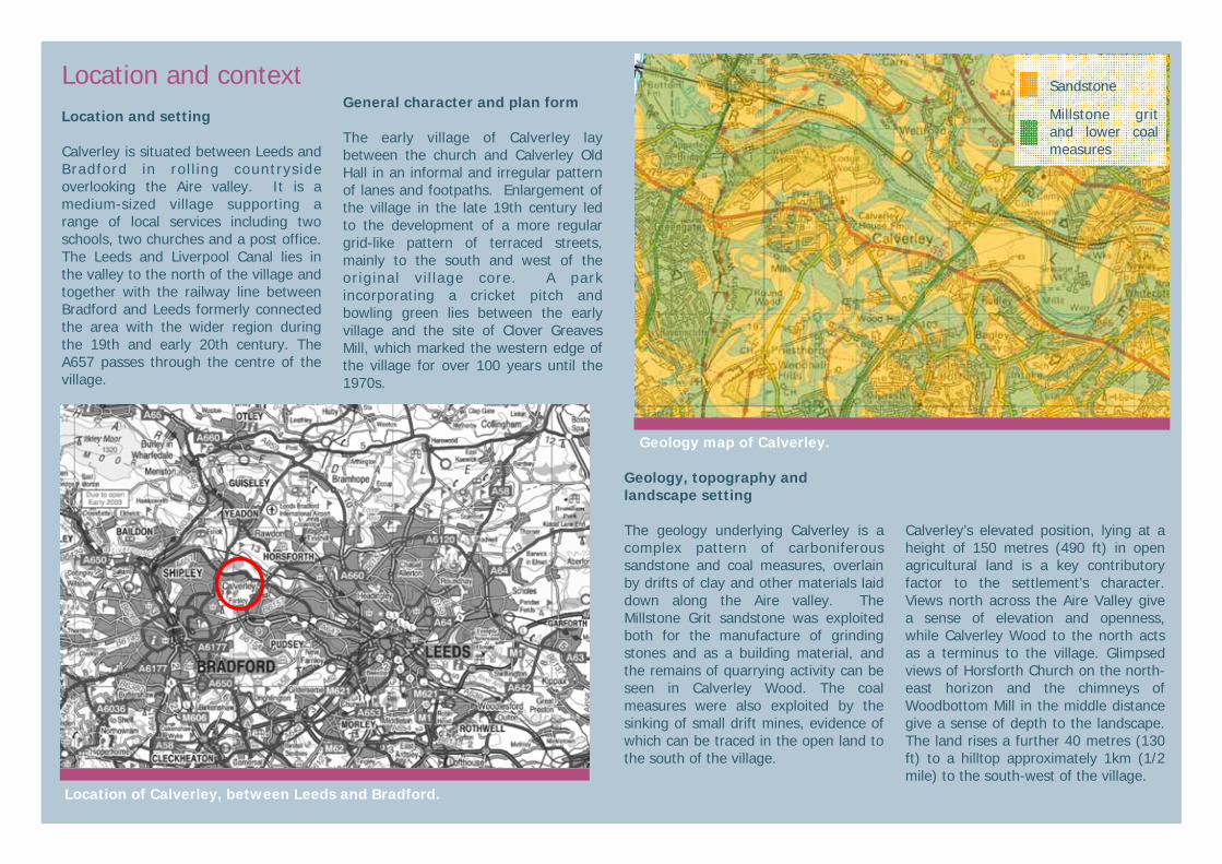
Location and context Location and setting Calverley is situated between Leeds and Bradford in rol l ing countryside overlooking the Aire valley. It is a medium-sized village supporting a range of local services including two schools, two churches and a post office. The Leeds and Liverpool Canal lies in the valley to the north of the village and together with the railway line between Bradford and Leeds formerly connected the area with the wider region during the 19th and early 20th century. The A657 passes through the centre of the village.
General character and plan form The early village of Calverley lay between the church and Calverley Old Hall in an informal and irregular pattern of lanes and footpaths. Enlargement of the village in the late 19th century led to the development of a more regular grid-like pattern of terraced streets, mainly to the south and west of the original vi l lage core. A park incorporating a cricket pitch and bowling green lies between the early village and the site of Clover Greaves Mill, which marked the western edge of the village for over 100 years until the 1970s.
Geology, topography and landscape setting The geology underlying Calverley is a complex pattern of carboniferous sandstone and coal measures, overlain by drifts of clay and other materials laid down along the Aire valley. The Millstone Grit sandstone was exploited both for the manufacture of grinding stones and as a building material, and the remains of quarrying activity can be seen in Calverley Wood. The coal measures were also exploited by the sinking of small drift mines, evidence of which can be traced in the open land to the south of the village.
Calverley’s elevated position, lying at a height of 150 metres (490 ft) in open agricultural land is a key contributory factor to the settlement’s character. Views north across the Aire Valley give a sense of elevation and openness, while Calverley Wood to the north acts as a terminus to the village. Glimpsed views of Horsforth Church on the north-east horizon and the chimneys of Woodbottom Mill in the middle distance give a sense of depth to the landscape. The land rises a further 40 metres (130 ft) to a hilltop approximately 1km (1/2 mile) to the south-west of the village.
Geology map of Calverley.
Sandstone
Millstone grit and lower coal measures
Location of Calverley, between Leeds and Bradford.

Historic development Origins and historic settlement Calverley is of Anglo-Saxon origin, its name deriving from the Old English “calfra” and literally meaning ‘clearing used for calves’. The historic core of the village probably originated in the early 7th century, close to where the church now stands, on the edge of Calverley Wood. Although the present church dates from about 1150, there is evidence to suggest that a pre-Norman building once stood on the site: several 10th-14th century cross slab grave covers have been found inside the church, along with a few early (possibly Anglo-Saxon) stones embedded in the chancel arch. The fact that the church is dedicated to St Wilfrid, an Anglo-Saxon saint, is also indicative of an early origin. A late Neolithic cup-marked rock in Calverley Wood indicates that this area may have held special significance in prehistoric times. There is also a possible prehistoric burial to the west side of St Wilfrid’s Church that suggest a Bronze Age presence in the area. Further evidence for Anglo-Saxon occupation of the area includes the possible site, situated to the north of Carr Road, of an Anglo-Saxon hall known as Arknell. A field named “Old Hall” on a map of the 1760s may indicate its former location.
Calverley is mentioned in the Domesday Survey of 1086, but the entry does not mention a hall or a church, although both probably existed at the time. The present St Wilfrid’s church was presented as a gift to the Archbishop of York in 1150; the south nave wall dates from this period, but much of the rest of the fabric dates from the 14th century and is Decorated in style. The upper stage of the tower was added in the 15th century. The church was extensively restored in the 19th century.
Apart from the church, the oldest building in the village is Calverley Old Hall, parts of which date from the 14th century. A timber-framed solar wing, lying between the hall and chapel, is the earliest surviving part of the building. It was encased in stone circa 1485 when the existing hall was built to replace an earlier one and the chapel built to the west of the solar. The Hall fell out of use as a manor house at the end of the 17th Century and was later sub-divided into cottages.
The manor of Calverley was sold by the last Sir Walter Calverley (also known as Sir Walter Blackett) in 1754 to the Thornhill family. A survey (reproduced left) commissioned by the new owner, Thomas Thornhill, gives a record of the extent of the village at this time as well as providing information about the surrounding agricultural land. It is clear from field names that there were extensive apple orchards around the village in the 1750s. The Thornhill Estate still owns large parts of Calverley township. In 1756 a workhouse was built in the village by Sir Walter Blackett. Formerly named Sir Walter Calverley, he had changed his surname as a condition of the inheritance of his uncle’s estates in Northumberland shortly before selling Calverley to the Thornhills. Sir Walter was a prominent parliamentarian and also endowed a hospital in Newcastle. All that remains of the Calverley workhouse is a commemorative plaque at its site.
Survey of the Manor of Calverley for Thomas Thornhill, circa 1755.
Late Medieval window in Calverley Old Hall, Woodhall Road.
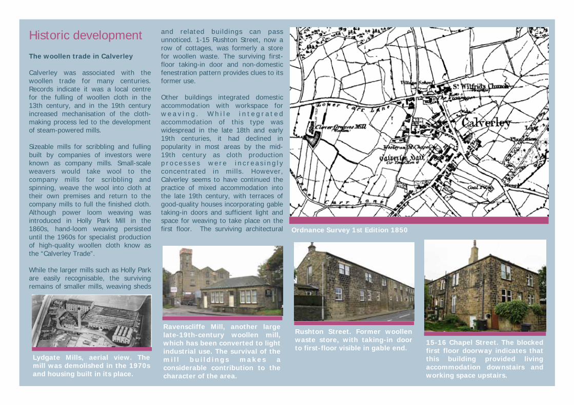
Historic development The woollen trade in Calverley Calverley was associated with the woollen trade for many centuries. Records indicate it was a local centre for the fulling of woollen cloth in the 13th century, and in the 19th century increased mechanisation of the cloth-making process led to the development of steam-powered mills. Sizeable mills for scribbling and fulling built by companies of investors were known as company mills. Small-scale weavers would take wool to the company mills for scribbling and spinning, weave the wool into cloth at their own premises and return to the company mills to full the finished cloth. Although power loom weaving was introduced in Holly Park Mill in the 1860s, hand-loom weaving persisted until the 1960s for specialist production of high-quality woollen cloth know as the “Calverley Trade”. While the larger mills such as Holly Park are easily recognisable, the surviving remains of smaller mills, weaving sheds
and related buildings can pass unnoticed. 1-15 Rushton Street, now a row of cottages, was formerly a store for woollen waste. The surviving first-floor taking-in door and non-domestic fenestration pattern provides clues to its former use. Other buildings integrated domestic accommodation with workspace for w e a v i n g . W h i l e i n t e g r a t e d accommodation of this type was widespread in the late 18th and early 19th centuries, it had declined in popularity in most areas by the mid-19th century as cloth production p r o c e s s e s w e r e i n c r e a s i n g l y concentrated in mills. However, Calverley seems to have continued the practice of mixed accommodation into the late 19th century, with terraces of good-quality houses incorporating gable taking-in doors and sufficient light and space for weaving to take place on the first floor. The surviving architectural Ordnance Survey 1st Edition 1850
Rushton Street. Former woollen waste store, with taking-in door to first-floor visible in gable end.
Lydgate Mills, aerial view. The mill was demolished in the 1970s and housing built in its place.
15-16 Chapel Street. The blocked first floor doorway indicates that this building provided living accommodation downstairs and working space upstairs.
Ravenscliffe Mill, another large late-19th-century woollen mill, which has been converted to light industrial use. The survival of the mi l l b u i ld ings makes a considerable contribution to the character of the area.

Historic development 19th century With the 19th-century expansion of the region’s manufacturing industries, Calverley’s situation within reach of the centre of Bradford made it a popular place for wealthy Bradford industrialists to live. Fred Foster, Lord Mayor of Bradford, lived for a time in Ferncliffe House, while the great industrialist and innovator Samuel Cunliffe Lister was born at Calverley House Farm. Elmwood and Brookleigh were also occupied by prominent families. In an effort to capitalise on this trend, in the 1850s the Thornhill Estate devised a plan to lay out portions of land in Calverley Wood to be developed as a select housing development for wealthy industrialists. Expressions of interest were received and the roads were laid out, but just two plots were sold and developed before the scheme was abandoned. However, the scheme had a considerable impact on the appearance of the village, as stone quarried during the creation of Calverley Cutting was used in the construction of most of Calverley’s late 19th century terraces. A chalybeate well to the south of the village enjoyed a brief spell of popularity in 1837, attracting visitors to Calver ley to take the waters. Unfortunately, the death of one person after “drinking too copiously of the waters” put a rapid end to the well’s popularity.
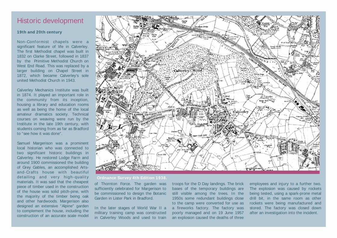
Ordnance Survey 2nd Edition 1894. The rapid expansion of the village between 1851 and 1894 is clear when this map is compared with the previous one. Capel Street, Clarke Street and the lower part of Thornhill Street have been developed, as well as several rows of workers’ housing close to Clover Greaves Mill. Ravenscliffe Mill has come into existence and Clover Greaves Mill expanded and re-built since the 1851 survey. The chapel on Carr Road has been built and the recreation ground has come into existence but its paths have not yet been laid out. Calverley Cutting, Clara Drive and Eleanor Drive can be seen cutting through Calverley Wood but Ferncliffe House and two pairs of semi-detached villas in the north part of the wood are the only results of the Thornhill’s plan for a large and splendid development. The line of the earlier packhorse route running due north from Clover Greaves Mill is still visible.
Historic development 19th and 20th century Non-Conformist chapels were a significant feature of life in Calverley. The first Methodist chapel was built in 1832 on Clarke Street, followed in 1837 by the Primitive Methodist Church on West End Road. This was replaced by a larger building on Chapel Street in 1872, which became Calverley’s sole united Methodist Church in 1943. Calverley Mechanics Institute was built in 1874. It played an important role in the community from its inception, housing a library and education rooms as well as being the home of the local amateur dramatics society. Technical courses on weaving were run by the Institute in the late 19th century, with students coming from as far as Bradford to “see how it was done”. Samuel Margerison was a prominent local historian who was connected to two significant historic buildings in Calverley. He restored Lodge Farm and around 1900 commissioned the building of Grey Gables, an accomplished Arts-and-Crafts house with beautiful detai l ing and very high-quality materials. It was said that the cheapest piece of timber used in the construction of the house was solid pitch-pine, with the majority of the timber being oak and other hardwoods. Margerison also designed an extensive “Alpine” garden to complement the house, including the construction of an accurate scale model
of Thornton Force. The garden was sufficiently celebrated for Margerison to be commissioned to design the Botanic Garden in Lister Park in Bradford. In the later stages of World War II a military training camp was constructed in Calverley Woods and used to train
troops for the D Day landings. The brick bases of the temporary buildings are still visible among the trees. In the 1950s some redundant buildings close to the camp were converted for use as a fireworks factory. The factory was poorly managed and on 19 June 1957 an explosion caused the deaths of three
employees and injury to a further two. The explosion was caused by rockets being tested, using a spark-prone metal drill bit, in the same room as other rockets were being manufactured and stored. The factory was closed down after an investigation into the incident.
Ordnance Survey 4th Edition 1938.

Character Analysis Spatial Analysis Settlement form The historic core of Calverley is of informal plan form and is not centred around any obvious landmark. The church and medieval hall do not act as focal points in the settlement. Instead, the junction of Blackett Street, West End Road and Thornhill Street acts as the focal point of the village, while surrounding lanes meander towards it from the outer portions of the village. There is a marked change in settlement form between the historic core and the 19th century extension of the village. The latter is characterised by a regular, linear form, with streets lined with terraced houses, each block of houses sharing a unified design. Activity and grain The historic core of Calverley has a fine-grained built environment, consisting of small, low-rise buildings of vernacular proportions. The late-19th-century expansion has a regular, open grain formed of long terraced streets articulated by breaks every 4-10 houses. The built environment is highly permeable, with numerous ginnels and back lanes available for pedestrian traffic. Activity levels are generally low, as is to be expected of a rural village, with Thornhill Street the main focus of activity, but the houses offer passive surveillance over the street and create a sense of safety and enclosure.
Key views and vistas Significant views within and out of the conservation area are shown on the map (right). Long views over the Aire Valley to the east and west give a sense of elevation and of the rural setting of the village. The spire of Horsforth Church on the north-east horizon is a significant landmark and e m p h a s i s e s t h e openness of the surrounding landscape. Views immediately to the north of the village are terminated by Calverley Wood, which prov ides a more intimate element to the rural views. Enclosed views along the drives in Calverley Wood area also significant. Within the village, views around Victoria Park contribute to the character of the area, as do views towards the church and 1-3 Town Gate. Views along the narrow, curving lanes in the historic core of the settlement are also highly significant. Landmarks Key landmarks in the conservation area are shown on the map (above). The two lodges at the southern end of Town Gate act as an entrance to Calverley,
while St Wilfrid’s Church and 1-3 Town Gate emphasise the northern edge of the village. The graveyards and the green at the eastern end of Carr Road create a sense of arrival in this area. The Mechanics Institute is a key landmark in the core of the village, while the chimney of Holly Park Mills is
a significant landmark to the south-west.
Key views and landmarks influencing the conservation area.
Built landmark Green landmark
View out of conservation area View within conservation area

Character Analysis Built environment Architectural characteristics Calver ley exhib its architectural characteristics typical of a West Yorkshire vil lage. Buildings are predominantly domestic in function, two or occasionally three storeys in height, with full-height gables and roof pitches between about 35o-45o. Regular fenestration patterns give a clear sense of unity to terraced facades. Chimneys are a prominent feature on almost all domestic properties. Blocked first-floor doorways are a significant feature on many buildings in the settlement. Materials The predominant building material in Calverley is gritstone, the vast majority of which was locally quarried. Fairly large, regular blocks are the norm, evenly coursed and pointed in a pale lime mortar. Window lintels and sills are predominantly of monolithic gritstone, as are window mullions. The retention of surviving stone mullions is to be encouraged, as they are an important contributor to the character of the village. Timber window frames are pa inted whi te throughout the conservation area. Roofs of early buildings are generally covered with stone “slates”, while later buildings use dark Welsh slate. Clay roof tiles are never used, and synthetic roofing materials are not in keeping with the conservation area.
Streetscape and public realm The historic core of the village is laid out in an informal manner. Narrow meandering streets create visual interest with the continual unfolding of enclosed progressive views. The areas of 19th century extension are laid out in a more formal pattern, but the scale of the streetscape remains domestic and there is a high level of visual interest. The public realm in the village is of l ower qua l i t y than the bu i l t environment. There is some survival of stone paving but it is generally in poor condition. Tarmac is the predominant paving material. Areas of public space such as the north end of Town Gate and Town Wells suffer from poor layout and lack of planned design. As a result of the busy nature of the A657 some road signs are backed by high-visibility yellow boards, which do not sit easily in a conservation area and detract from the quality of the public realm. Greenscape Calverley is surrounded by open agricultural land which forms an essential part of the conservation area’s greenscape. Calverley Wood is designated an Ancient Woodland and is another key element of the greenscape of the area. Victoria Park is an important area of formal green space within the settlement. The main entrance, off Carr Road, is dominated by the War Memorial and an area of formal planting, while an avenue of trees delineates the east side of the park. Woollen weavers’ dwellings close to Clover Greaves Mill.
Vernacular cottages on the Wicket, dating from before 1755

Character Analysis Positive buildings The buildings coloured green on the map (right) make a positive contribution to the character of the conservation area. This contribution may be in one or more of the following ways: • Landmark buildings • Buildings which provide evidence of
the area’s history and development • Buildings of architectural merit • Buildings with local historical
associations • Buildings which exemplify local
vernacular styles • Groups of buildings which together
make a positive contribution to the streetscape
There should be a presumption in favour of their retention in all but exceptional circumstances.
Character Areas Calverley conservation area is not a uniform area. Different parts of the village were developed at different periods in history and contain different types of buildings and spaces. The conservation area can therefore be divided into sub-areas known as character areas. Each area has a different character and distinct built forms, generated by the period of its development and the function of the buildings and spaces. A shared palette of construction materials and landscape unifies all the character areas within the conservation area.
Positive buildings shaded in green.
C a l v e r l e y M e c h a n i c s Institute, built 1873.
Former lodge to Brookleigh, 30 Town Gate.
24 Shell Lane, one of three late 19th century villas built on the southern edge of Calverley.
Coach house and stable, 28 Town Gate.

Character Analysis Character area 1—historic core This area encompasses the historic core o f Ca l v e r l e y . I t s bounda r y approximates to the extent of the village in 1850 and generally follows roads and lanes which can be traced on early maps. Key characteristics: • Informal arrangement of buildings
and narrow lanes • Sense of enclosure and intimate
scale of surroundings • Fine-grained built form • Variety in size and status of buildings • Coursed gritstone and stone roof
slate the predominant building materials
Key ways to retain character: • Use of gritstone as predominant
walling material • Retention of vernacular built form • Retention of stone slate roofs and
chimneys • Retention of informal layout of
buildings and streets • Retention and reinforcement of fine
grain of built form
West End Road, with an informal arrangement of vernacular stone houses characteristic of the historic core.
Character Area 1 shaded in green.
Ginnels provide permeability and have been a feature of the village for centuries.
The palette of vernacular materials in the historic core is a key element of character.

Character Analysis Character area 2— late 19th-century expansion This area encompasses the late 19th century extension to the village. It is associated with the growing significance of the woollen industry in the village. Key characteristics: • Terraced buildings constructed of
coursed gritstone with slate roofs • Two- or three-storey in height • Grid-like street pattern with regular
arrangement of buildings in relation to the street
• Front gardens enclosed by low stone walls
• Blocked taking-in doors Key ways to retain character: • Retention of visible evidence for
taking-in doors and historic window openings
• Retention of front gardens with gritstone garden walls
• Retention of stone or slate roofs and chimneys
• Retention of window proportions, including retaining stone mullions in situ where they survive.
• Retention of buildings related to the woollen trade.
9-15 Capel Street, constructed around the turn of the 20th century. The decorative hood moulds over the front doors and imposing window mullions contribute to the character of the street. The survival of the original horned sash windows also enhances the buildings.
1-15 Woodhall Road, built in the late 19th century. Number 15 is larger than the others in the row and had a taking-in door in the gable. The first floor was formerly used for weaving, while the ground floor provided living accommodation.
Character Area 2 shaded in blue.
Woodland View, an example of three-storey housing associated with the woollen industry. Although this type of housing had died out in most areas by the late 19th century, specialist weavers of “fancy-work” continued to work at home rather than in factories. The two-storey house at the end of the terrace also had storage or working space on the first floor. The third floor of the terrace would have been used as a loom-shop.
Ravenscliffe Mill, a surviving example of a large late-19th-century woollen mill.
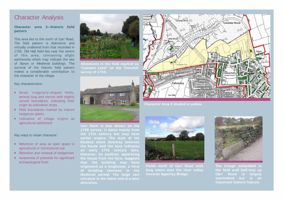
Character Analysis Character area 3—historic field pattern This area lies to the north of Carr Road. The field pattern is distinctive and virtually unaltered from that recorded in 1755. Old Hall field lies near the centre of this area, containing sl ight earthworks which may indicate the site of Saxon or Medieval buildings. The survival of the historic field pattern makes a considerable contribution to the character of the village. Key characteristics: • Small, irregularly-shaped fields,
several long and narrow with slightly curved boundaries, indicating their origin as cultivation strips
• Field boundaries marked by mature hedgerow plants
• Indicative of village origins as agricultural settlement
Key ways to retain character: • Retention of area as open space in
agricultural or horticultural use • Retention and renewal of hedgerows • Awareness of potential for significant
archaeological finds
Allotments in the field marked as “Lampits Land” on the Thornhill survey of 1755.
Character Area 3 shaded in yellow.
Carr Farm is also shown on the 1755 survey. It dates mainly from the 17th century but may have earlier origins. The style of the blocked stone doorway between the house and the byre indicates an early 17th century date. However, its position, separating the house from the byre, suggests that the building may have originated as a longhouse, a form of building common in the Medieval period. The large cart entrance in the lower end is a later alteration.
Fields north of Carr Road with long views over the river valley towards Apperley Bridge.
The trough embedded in the field wall half-way up Carr Road is largely overlooked but is an important historic feature.
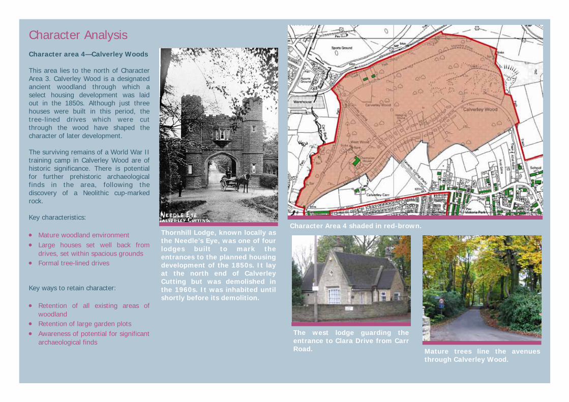
Character Analysis Character area 4—Calverley Woods This area lies to the north of Character Area 3. Calverley Wood is a designated ancient woodland through which a select housing development was laid out in the 1850s. Although just three houses were built in this period, the tree-lined drives which were cut through the wood have shaped the character of later development. The surviving remains of a World War II training camp in Calverley Wood are of historic significance. There is potential for further prehistoric archaeological finds in the area, following the discovery of a Neolithic cup-marked rock. Key characteristics: • Mature woodland environment • Large houses set well back from
drives, set within spacious grounds • Formal tree-lined drives Key ways to retain character: • Retention of all existing areas of
woodland • Retention of large garden plots • Awareness of potential for significant
archaeological finds The west lodge guarding the entrance to Clara Drive from Carr Road.
Character Area 4 shaded in red-brown.
Mature trees line the avenues through Calverley Wood.
Thornhill Lodge, known locally as the Needle’s Eye, was one of four lodges built to mark the entrances to the planned housing development of the 1850s. It lay at the north end of Calverley Cutting but was demolished in the 1960s. It was inhabited until shortly before its demolition.
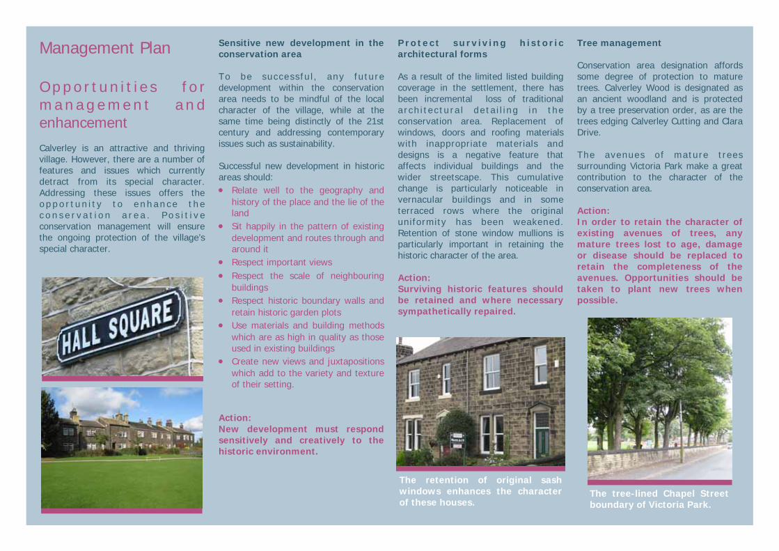
Management Plan O p p o r t u n i t i e s f o r m a n a g e m e n t a n d enhancement Calverley is an attractive and thriving village. However, there are a number of features and issues which currently detract from its special character. Addressing these issues offers the o p p o r t u n i t y t o e n h a n c e t h e c o n s e r v a t i o n a r e a . P o s i t i v e conservation management will ensure the ongoing protection of the village’s special character.
Sensitive new development in the conservation area To be success fu l , any future development within the conservation area needs to be mindful of the local character of the village, while at the same time being distinctly of the 21st century and addressing contemporary issues such as sustainability. Successful new development in historic areas should: • Relate well to the geography and
history of the place and the lie of the land
• Sit happily in the pattern of existing development and routes through and around it
• Respect important views • Respect the scale of neighbouring
buildings • Respect historic boundary walls and
retain historic garden plots • Use materials and building methods
which are as high in quality as those used in existing buildings
• Create new views and juxtapositions which add to the variety and texture of their setting.
Action: New development must respond sensitively and creatively to the historic environment.
Protect surv iv ing h is tor ic architectural forms As a result of the limited listed building coverage in the settlement, there has been incremental loss of traditional a rch i tec tu ra l de ta i l i ng in the conservation area. Replacement of windows, doors and roofing materials with inappropriate materials and designs is a negative feature that affects individual buildings and the wider streetscape. This cumulative change is particularly noticeable in vernacular buildings and in some terraced rows where the original uniformity has been weakened. Retention of stone window mullions is particularly important in retaining the historic character of the area. Action: Surviving historic features should be retained and where necessary sympathetically repaired.
Tree management Conservation area designation affords some degree of protection to mature trees. Calverley Wood is designated as an ancient woodland and is protected by a tree preservation order, as are the trees edging Calverley Cutting and Clara Drive. The avenues of mature trees surrounding Victoria Park make a great contribution to the character of the conservation area. Action: In order to retain the character of existing avenues of trees, any mature trees lost to age, damage or disease should be replaced to retain the completeness of the avenues. Opportunities should be taken to plant new trees when possible.
The tree-lined Chapel Street boundary of Victoria Park.
The retention of original sash windows enhances the character of these houses.

Examples of opportunities for enhancement of the conservation area Protect archaeological remains Calverley has been inhabited for over 1000 years and buried evidence of past occupation is likely to survive. Development which may disturb archaeological remains may require a watching brief to ensure the preservation of archaeological finds. Action: Development which involves below-ground excavation must have regard to the potential for archaeological finds.
Calverley Cutting Calverley Cutting is a popular destination for walks, both for residents of Calverley and for others. The network of paths around the Cutting connects elements of the historic environment including the failed 1850s development, the World War II military camp and prehistoric archaeological features, as well as facilitating enjoyment of the ancient woodland itself. There is currently no on-site in te rp re ta t ion o f the h i s to r i c environment and there may be opportunities to enhance some areas such as the Carr Road entrance to the Cutting. Action: Support local community groups in enhancing understanding and enjoyment of the historic environment of Calverley Cutting.
Public realm on Victoria Street Despite the generally high quality of Calverley’s built environment, the corner of Victoria Street and Thornhill Street suffers from considerable degradation. Loss of the boundary wall to the rear of 100 Thornhill Street has created an area of dead space which is neither private nor public. The low quality of surfacing materials and the lack of delineation between public and private space, as well as the setting of the bus stop, isolated at the front of the pavement, further detracts from the character of the area. Action: As opportunity arises, develop an enhancement scheme for the east end of Victoria Street.
Public realm on Town Gate The corner of Town Gate adjacent to St Wilfrid’s Church and 1-3 Town Gate is an important area of public space in the village. It provides the setting for three important buildings and offers key views of the conservation area. The area in front of 1-3 Town Gate is not laid out in a manner which enhances the setting of these important buildings, and its informal use as a parking place discourages pedestrians. A scheme to re-consider the public realm to enhance the setting of the historic buildings and make the area more pedestrian-friendly could considerably enhance the conservation area. Action: As opportunity arises, develop an enhancement scheme for the corner of Town Gate.
The Carr Road entrance to Calverley Cutting presents opportunities for enhancement.
The lack of delineation between public and private space creates a “dead” area around the bus stop.
Town Gate could be re-ordered to discourage unauthorised parking and improve pedestrian amenity.
Evidence for past occupation of Calverley is to be found throughout the village.
Examples of opportunities for enhancement of the conservation area Street lighting The street lights in Calverley are due to be replaced in 2011. New lighting columns should respect the eaves heights of adjacent buildings and should be placed to the rear of the footway to reduce street clutter. Tall lighting columns should be avoided. Action: The forthcoming street lighting plan should respect the historic streetscape and proportions of buildings.
Paving and surfacing The surviving stone paving in Calverley is in poor condition, with many footways containing cracked flagstones, largely caused by vehicles mounting the kerbs. The retention of existing stone paving flags, setts and kerbstones is important in maintaining the historic character of the settlement. Opportunities should be taken as they arise to enhance areas of stone paving which are in poor repair and to improve the junction between stone and modern paving. Action: Retain and enhance historic paving in the conservation area.
Inappropriate infill development A number of buildings in the conservation area lie in sizeable gardens . Inappropr ia te in f i l l development would harm the character of the conservation area by altering the relationship between existing buildings and the spaces around them. Intensification of development which disrupts the character of the conservation area should be resisted. The scale, massing and proportion of buildings as well as the spaces between them are important in retaining the character of the conservation area. Action: Any development proposing the infill of a site, or the subdivision of a plot, should respond the scale, massing, layout and distribution of positive structures within the conservation area.
Development affecting the setting of the conservation area It is important that development around the conservation area does not harm its setting. Any development in or around Calverley which affects the setting of the conservation area should have regard to views into and out of the conservation area, the setting of positive buildings and the character of the landscape. Appropriate design and mate r ia l s shou ld be used in deve lopment ad jacen t to the conservation area. Action: The impact of development on the character and appearance of the conservation area should be considered. This applies equally to d e v e l o p m e n t o u t s i d e t h e conservation area if it is likely to affect the setting of the conservation area.
New lamp post materials should be more appropriate for the conservation area.
New buildings in the conservation area should respond to the context of the site.
The open landscape and long views contribute to the character of the conservation area.
Stone flags broken by vehicles mounting the kerb illegally. Where possible damaged stone flags will be repaired or replaced with materials of similar quality and appearance.

N
Key map of the conservation area

References Publications: • Caffyn, L. Workers Housing in
West Yorkshire 1750-1920 London 1986
• Calverley Urban District Council Calverley London [date unknown]
• Giles, C. Rural Houses of West Yorkshire 1400-1830 London 1986
• HMSO Report into fatal accident at Guy’s Fireworks 1957.
• Harrision, J.A. A West Riding Childhood Guisley 1968
• Pevsner,N. West Riding of Yorkshire London 1974
• Pudsey Civic Society Calverley in Old Picture Postcards Leeds 2005
• Round a Yorkshire Alpine Garden Extract from Yorkshire Daily Observer, June 4, 1904.
Copyright Maps based on Ordnance Survey material are reproduced with the permission of the Ordnance Survey on behalf of the Controller of Her Majesty’s Stationery Office © Crown copyright. Unauthorised reproduction infringes Crown copyright and may lead to prosecution and/or civil proceedings. The map data, derived from Ordnance Survey mapping, included within this publication is provided by Leeds City Council under licence from Ordnance Survey. Leeds City Council Licence No. (100019567 2008).
Acknowledgements • The preparation of this report
was made possible through funding by the Outer West Local Area Committee of Leeds City Council
• Ian Sanderson and Jason Dodds of West Yorkshire Archaeological Advisory Service provided archaeological information and advice.
How to find out more about local history If you are interested in local history, the Pudsey Civic Society has published a number of books about Calverley’s history. They manage a local history archive and are available every Friday between 10am and 12noon in Pudsey library to assist anyone interested in researching local or family history. A wide range of original documents, public records and books can also be found in the following locations:
• Central Library (Local & Family History Section), The Headrow, Leeds LS1. Tel 0113 247 8290 email: [email protected] website: www.leeds.gov.uk/library
• West Yorkshire Archive Service, Chapeltown Road, Sheepscar, Leeds LS73AP. Tel-0113 214 5814 email: [email protected] website: www.archives.wyjs.org.uk
• West Yorkshire Archaeological Advisory Service, Newstead Road, Wakefield WF1 2DE Tel 0 1 9 2 4 3 0 6 8 1 0 e m a i l : [email protected] website: www.arch.wyjs.org.uk
In addition, much information is available on other websites:
• www.heritagegateway.org.uk includes all l isted building descriptions and some photos
• www.leodis.net has archive photos of the Leeds district
• www.old-maps.co.uk has early Ordnance Survey maps.
How to find out more about historic buildings Leeds Central Library has a large architecture collection which includes books on historic buildings. A useful general book on understanding historic houses is How Old is Your House? By Pamela Cunnington (most recent publication 2002). Shire Books also publish a range of excellent short books on historic buildings.
There are a wide range of national societies devoted to the study and conservation of historic buildings. Many of these national bodies have regional groups in Yorkshire. • Society for the Protection of
Anc ient Bu i l d ings (SPAB) www.spab.org.uk . A good source of practical information about looking after buildings of all periods.
• Ancient Monuments Society www.ams.org.uk . Devoted to the study and conservation of ancient monuments, historic building and fine old craftsmanship, with a particular interest in church buildings.
• G e o r g i a n G r o u p www.georg iangroup.o rg .uk Interested in the study and conservation of 18th- and early 19th-century buildings.
• V i c t o r i a n S o c i e t y www.victoriansociety.org.uk Interested in the appreciation and conservation of 19th and early 20th century buildings of all types.
• 2 0 t h C e n t u r y S o c i e t y www.c20century.org.uk Active in promoting appreciation and protection of 20th century architecture.
Adult education courses on historic buildings and/ or local history are sometimes run in Leeds or Bradford —check with your local provider for current information.
Finding Out More What is a conservation area?
A conservation area is ‘an area of special architectural or historic interest the character or appearance of which it is desirable to preserve or enhance’.
Section 69 of the Planning (Listed Buidlings and Conservation Areas) Act 1990.
What does conservation area status mean?
Conservation area status provides the opportunity to promote the protection and enhancement of the special character of the defined area. Designation confers a general control over development that could damage the area’s character. The details are complex but can be summarised as: • Most demolition requires permission
and will be resisted if the building makes a positive contribution to the area.
• Some minor works to houses is no longer "permitted development" and will require planning permission. Examples are rear dormer windows, external cladding and most satellite dishes on front elevations.
• Advertisement controls are tighter • Most work to trees has to be notified
to the Council which has six weeks in which to decide to impose restrictions.
• Generally, higher standards of design apply for new buildings and alterations to existing ones.
Change is inev i tab le in most conservation areas and it is not the intention of the designation to prevent the continued evolution of places. The challenge within conservation areas is to manage change in a way that maintains, reinforces and enhances the special qualities of the area. What is the purpose of this appraisal?
This appraisal provides the basis for making informed, sustainable decisions in the positive management, protection and enhancement of the conservation area. It provides a clear understanding of the special interest of Calverley by: • accessing how the settlement has
developed • analysing its present day character
and • ident i fy ing opportuni t ies for
enhancement This appraisal follows the current guidance set out by English Heritage in the 2006 publication Guidance on Conservation Area Appraisals. The appraisal is not intended to be comprehensive and the omission of any particular building, feature or space
should not be taken to imply that it is of no interest.
Planning policy context
This appraisal should be read in conjunction with the wider national, regional and local planning policy and guidance. Relevant documents include: • Planning (Listed Buildings and
Conservation Areas) Act 1990 • Planning Policy Guidance 15:
P l a nn i n g a nd t he H i s t o r i c Environment
• Planning Policy Guidance 16: Archaeology and Planning
• The Yorkshire and Humber Plan (The Regional Spatial Strategy) May 2008, particularly Policy ENV9 Historic Environment
• Leeds C i ty Counc i l , Un i tary Development Plan Review 2006, particularly Chapter 5 Environment and Appendices A3 Building Design, Conservation and Landscape Design and A4 Archaeological Policies
• L e e d s C i t y C o u n c i l , L o c a l Development Framework, emerging document that will ultimately replace the Local Plan.
Community involvement and adoption
This draft appraisal went through a public consultation process. A six week period of public consultation included: • An exhibition at the local library,
with access to a paper copy of the appraisal
• A public drop-in meeting to discuss the proposed changes
• The appraisal was made available through the Council’s website
• Leaflets were delivered to all homes affected by the proposed change to the conservation area boundary.
The consultation responses were evaluated and the appraisal amended in light of comments received. This document was approved by Leeds City Council in April 2009. Once adopted, the appraisal is a material consideration when applications for change within the conservation area or its setting are considered by the Council.
Published in April 2009 by the Sustainable Development Unit, Leeds City Council, The Leonardo Building, 2 Rossington Street, Leeds LS2 8HD Tel 0113 247 8000 email: [email protected] website www.leeds.gov.uk/conservation