CalNex Forecast Prepared Monday 24 May 2010. Anticipated Platform Activities WP-3D [Sunday May 23:...
60
CalNex Forecast Prepared Monday 24 May 2010
-
Upload
christian-wade -
Category
Documents
-
view
215 -
download
1
Transcript of CalNex Forecast Prepared Monday 24 May 2010. Anticipated Platform Activities WP-3D [Sunday May 23:...

CalNex Forecast
Prepared Monday
24 May 2010

Anticipated Platform Activities
WP-3D [Sunday May 23: Flight scrubbed due to turbulence along the planned track.] Monday May 24: An afternoon-into-night flight to the southern San Joaquin Valley. Tuesday: LA afternoon-into- night flight. Wednesday and Thursday: iffy with clouds and rain in the forecast, so anticipate one and perhaps two no-fly days. NOAA Twin Otter: Monday: AM/PM flights in SoCAB Tuesday: AM/PM flights in SoCAB CIRPAS Twin Otter: NASA King Air: R/V Atlantis: Monday: Santa Monica Bay to LA harbor. Tuesday: LA Harbor to W of San Nicolas looking for clouds? Friday: Port of LA

Local Features
Monday: P3 afternoon-to-night flight to southern San Joaquin Valley
clouds expected to dissipate and not cause any problems; good AQ
Tuesday: P3 afternoon-to-night flight in SoCal winds lighter than Sunday and clouds not expected to cause any problems; onshore flow; good AQ

Synoptic Overview for California
Monday May 24 • Large upper low remains over Gulf of Alaska • Trough moves E into Great Basin• Transport flow shifts NW• Onshore surface flow both north and south
Tuesday May 25
• Strong shortwave trough rotates through the north half of CA• Rain possible north of Monterey• Transport flow turns W/SW• Onshore surface flow continues
Wednesday May 26
• Precip continues for Sierra• Shortwave trough rotates through central CA late
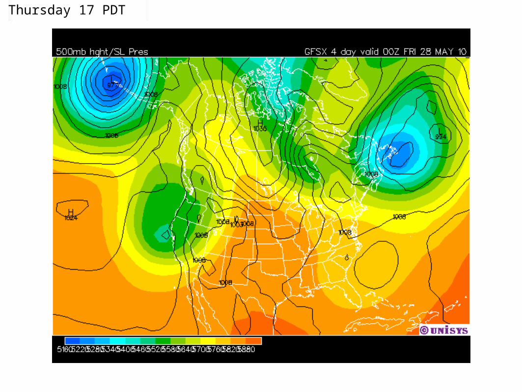
Thursday-Friday May 27-28
• Rain possible Thursday from Monterey northward but lighter than Tuesday• Upper low opens up and moves SE through the state Friday• Weak ridging returns for weekend? Maybe

Sunday 17 PDT Analysis

Monday 05 PDT

Monday 17 PDT

Tuesday 05 PDT

Tuesday 17 PDT

Wednesday 05 PDT

Wednesday 17 PDT

Thursday 05 PDT
Thursday 17 PDT

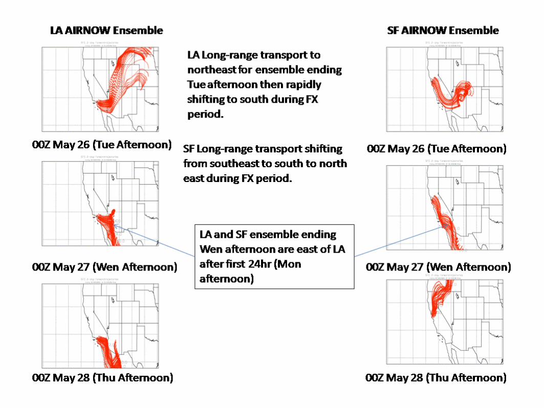
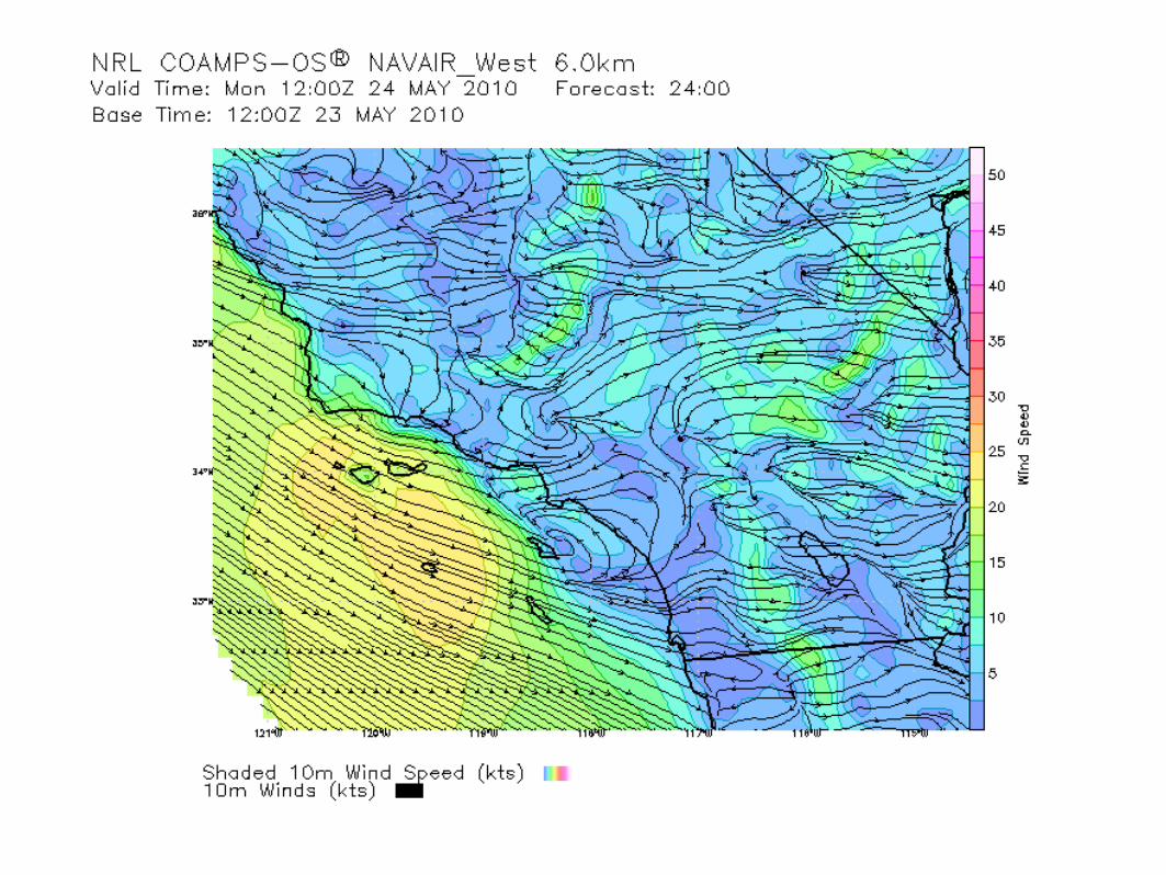
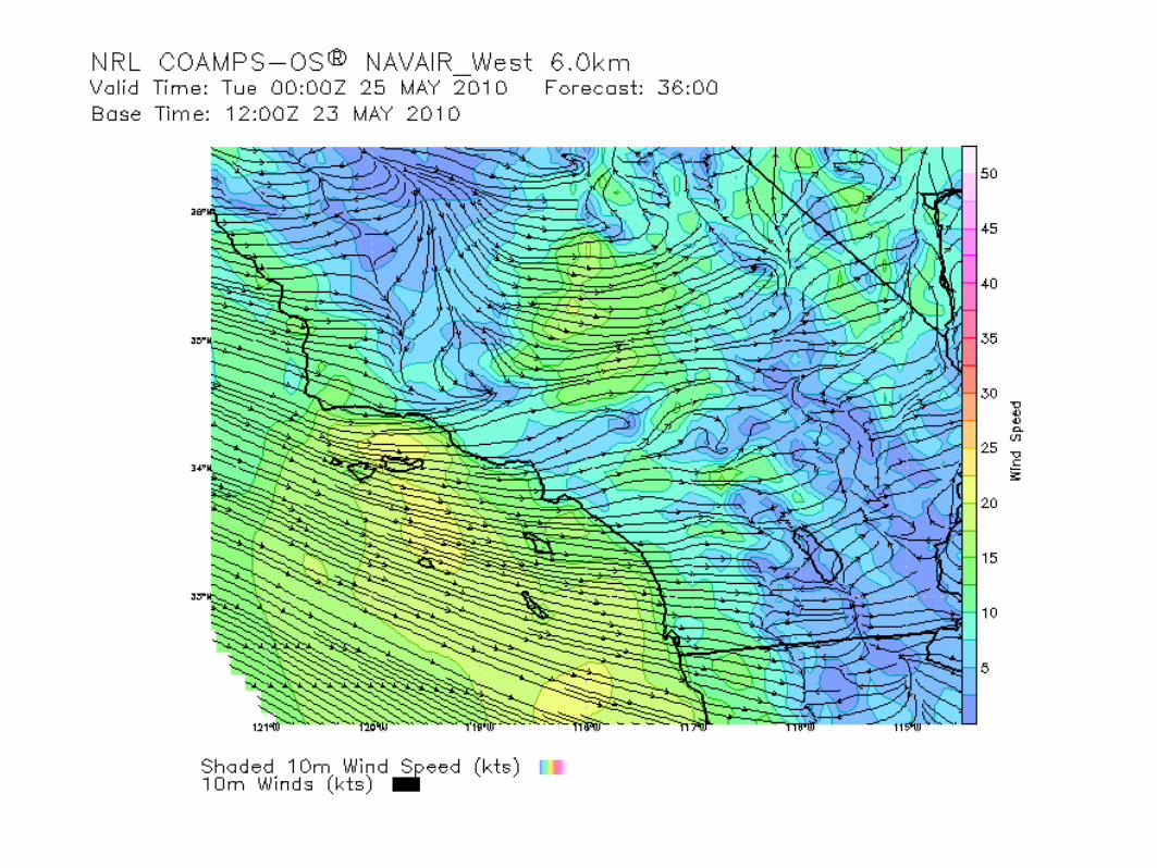
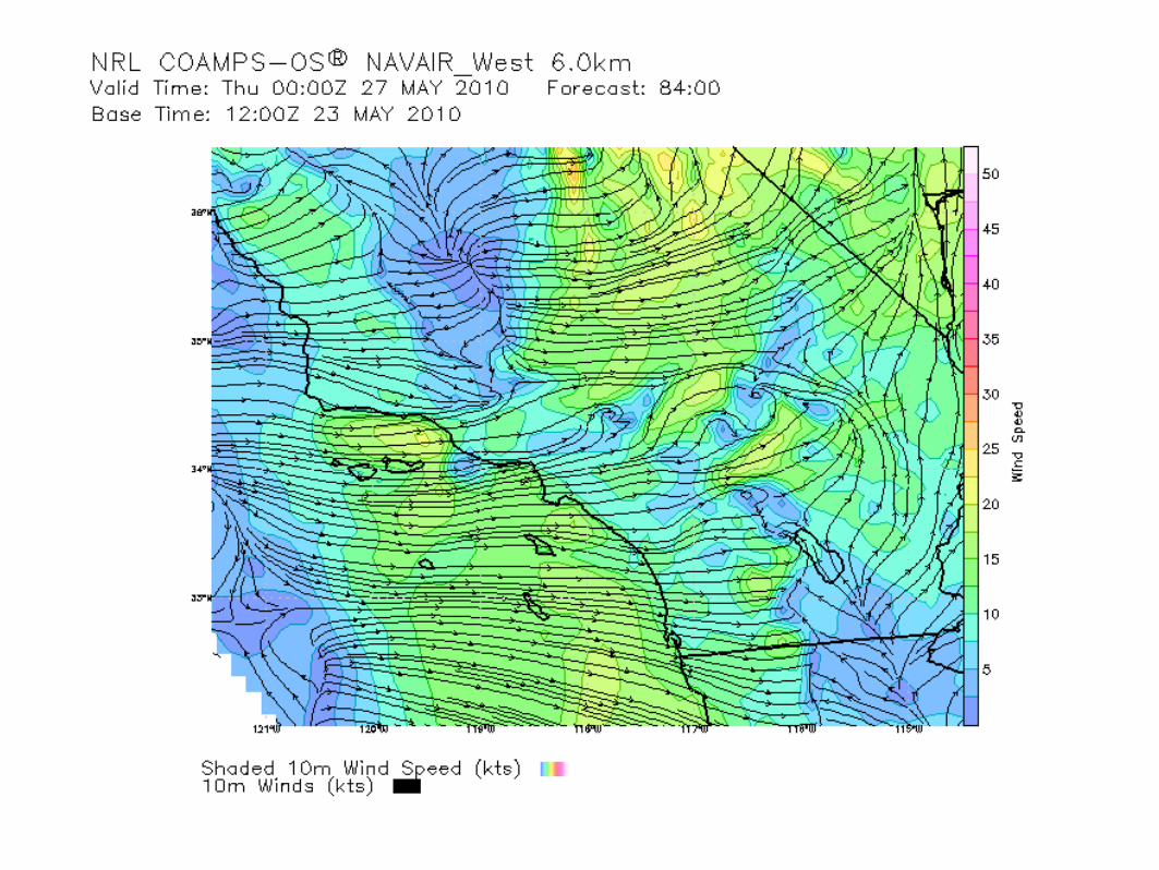
Large Scale Transport
RAQMS FX updated Monday, May 24th.


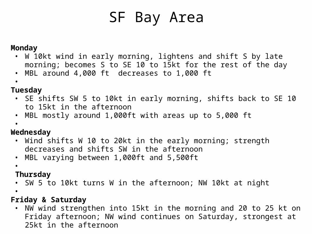
SF Bay Area
Monday• W 10kt wind in early morning, lightens and shift S by late morning; becomes S to SE
10 to 15kt for the rest of the day• MBL around 4,000 ft decreases to 1,000 ft•
Tuesday• SE shifts SW 5 to 10kt in early morning, shifts back to SE 10 to 15kt in the afternoon• MBL mostly around 1,000ft with areas up to 5,000 ft•
Wednesday• Wind shifts W 10 to 20kt in the early morning; strength decreases and shifts SW in
the afternoon• MBL varying between 1,000ft and 5,500ft•
Thursday• SW 5 to 10kt turns W in the afternoon; NW 10kt at night•
Friday & Saturday• NW wind strengthen into 15kt in the morning and 20 to 25 kt on Friday afternoon;
NW wind continues on Saturday, strongest at 25kt in the afternoon

Sacramento ValleyMonday
• Light SE downslope flow early AM for northern SV, S 10kt onshore flow for southern SV; SW 5 to 10kt for the rest of day, stronger in the afternoon; onshore flow from the delta and some from south SF Bay
• AM PBL 1,500ft; PM PBL 5,000ft• Max aftn temp: 20C• Thick layer of altrostraus already in the region, may partially break up into stratocumulus, more
stratus in the afternoon and evening• Good air quality: max 8-hr mean O3 in 0.05 ppm range•
Tuesday• Light S to SE flow from SJV and downslope flow in the morning; S 5 to 10kt wind during the day; S
wind continues (northern SV) and SW onflow through the delta (southern SV) in the evening• AM PBL 1,000 ft; PM PBL 4,500 to 8,000 ft• Max aftn temp: 18C• Stratus and altostratus lingers over the region, completely overcast after sunrise; clearing in the
evening; 80% chance of rain;• Good air quality: max 8-hr mean O3 in 0.04 ppm range

Sacramento Valley (cont'd)
Wednesday• SW onshore through the delta for southern SV in early morning, otherwise S to W 5kt, between 5 to
10kt during the afternoon hours (COAMPS indicates 15kt in the afternoon)• Max aftn temp: 17C• AM PBL 1,000 to 7,000ft; PM PBL 4,000 to 8,000ft• Scattered cumulus and stratocumulus; 40% chance of rain, decreases though the day• Good air quality: max 8-hr mean O3 in 0.04 ppm range•
Thursday• Light S and SE wind; SW 5kt in the afternoon turns W 5kt in the evening• Increasing altostratus after midnight; completely overcast with stratus by late morning; breaks up
night; 60% chance of rain• Max aftn temp: 17C• Good air quality: max 8-hr mean O3 in 0.04 ppm range•
Friday & Saturday• Light W on Friday; downslope flow resumes for early AM hours; NW wind on Saturday• Scattered cumulus on Friday, mostly clear on Saturday• Good air quality

San Joaquin Valley (Prepared on May 24, 2010 at 9:15 AM)
Monday May 24, 2010: Wind Flow: The lower air profilers this morning depict light to moderate northwesterly wind flow throughout the atmospheric
profile. Surface winds today will be light and variable. Inflow into the SJV will be from Pacheco and Cottonwood passes. Very weak inflow will come through the Altamont and Delta later this afternoon decreasing overnight. Outflow will be toward the Deserts. Typical, up slope and down slope flow will occur over the Sierra's (mountainous terrain).
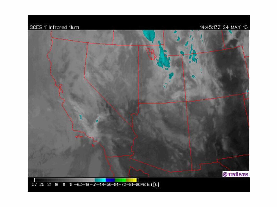
Boundary layer mixing heights: This morning's aircraft sounding from Bakersfield depict a moderate inversion of 9 degrees Fahrenheit. Isothermal conditions exist over Fresno. A mid level cloud deck is currently over the SJV this morning. These clouds are between 7000 and 15000 feet. The visible satellite loop shows the clouds moving toward the south and southeast and breaking up in various locations over central California. The 0Z CANSAC model shows maximum boundary layer mixing heights between 4,500 and 5,500 feet this afternoon. These heights may not be realized due to cloud cover slowing down solar radiation. Toward sunset, the mixing heights will lower as a weak inversion reforms over the SJV.
Air Quality: Good air quality conditions are predicted District-wide through the upcoming week.

San Joaquin Valley (cont'd)Tuesday May 25, 2010:
Wind flow: The 0Z CANSAC model depicts light and variable wind flow throughout the entire SJV. Downslope flows will exist over the mountains. Weak synopically driven outflow is present toward the Kern Deserts. Surface winds will be light, with onshore gradients present over the Cottonwood, Pacheco pass and outflow toward the Deserts.
Boundary layer mixing heights: Limited maximum mixing depths is forecast to occur from Merced county northward tomorrow afternoon (probably due to increasing cloudiness from the approaching system). Better mixing conditions will exist from Fresno southward tomorrow afternoon(between 4,000 to 5,000 feet) due to a little more solar heating.
Wednesday through Friday, May 26 and 28, 2010:Good dispersion conditions are predicted to continue through the early part of the weekend as the trough lingers over California.

Central CoastPrepared 5/24/2010 - 6 am PST
Current Wx: Cloudy in SLO. Well mixed atmosphere Ft Ord: No inv Lost Hills: Wk sfc inv SW flow ridgetops Temblor Range Synopsis 5/24 – 5/30: Unsettled weather continues – models indicate persistent trough over west coast US through the end of the week-NW flow along the coast – W to SW inland-Blowing dust in afternoons – Oceano Dunes/Nipomo Mesa Friday & Saturday. -Sundowner winds possible canyons near Gaviota Friday - Saturday Yesterday, Sunday: Trough/cutoff low over CA. Blowing dust in afternoon/ Moderate AQ– Oceano Dunes/Nipomo Mesa Today, Monday 5/24: Trough NV, NW flow aloft over CA. W flow over SLO County. Tuesday: Broad trough approaching CA. SW flow eastern San Luis Obispo County ridgetops/Temblor Range Wednesday: Trough CA – chance precipitation. SW flow aloft. Thursday: Trough deepening over CA – chance precipitation. WSW flow aloft.

Central Coast (cont'd) Friday: Trough deepening over CA – chance precipitation, NW flow aloft. Blowing dust in afternoon/Moderate AQ – Oceano Dunes/Nipomo Mesa Saturday: Trough UT, NW flow aloft CA. Blowing dust in afternoon/Moderate AQ – Oceano Dunes/Nipomo Mesa, NE flow eastern San Luis Obispo County ridgetops/Temblor Range Sunday: Trough over CA (GFS). Air quality: Good air quality with exception - Blowing dust midday/ afternoons-Oceano Dunes/Nipomo Mesa - Moderate AQ – Friday 5/28, Saturday 5/29 Significant features for study: Blowing dust Oceano Dunes/Nipomo Mesa peaking midday/afternoons - Friday 5/28 – Saturday 5/2

Southern Coastal Waters


South Coast
NO FORECAST TODAY - more troughing, cool, even more rain this week. Temps not near normal until Saturday

Northern California
Observed, Model-Interpolated Winds for SF Bay http://sfports.wr.usgs.gov/cgi-bin/wind/windbin.cgi
and COAMPS Wind Plots
http://www.sccoos.org/data/coamps/coamps.html