California State Capitol Museum: Capitol Park Monument...
22
California State Capitol Museum: Capitol Park Monument and Memorial Guide California State Capitol Museum 10th and L Streets (916) 324-0333 State Capitol, Room B-27 www.capitolmuseum.ca.gov Sacramento, CA 95814 Page 1 Last Updated 5/20/2016
Transcript of California State Capitol Museum: Capitol Park Monument...

California State Capitol Museum:Capitol Park Monument and Memorial Guide
California State Capitol Museum 10th and L Streets(916) 324-0333 State Capitol, Room B-27www.capitolmuseum.ca.gov Sacramento, CA 95814
Page 1 Last Updated 5/20/2016
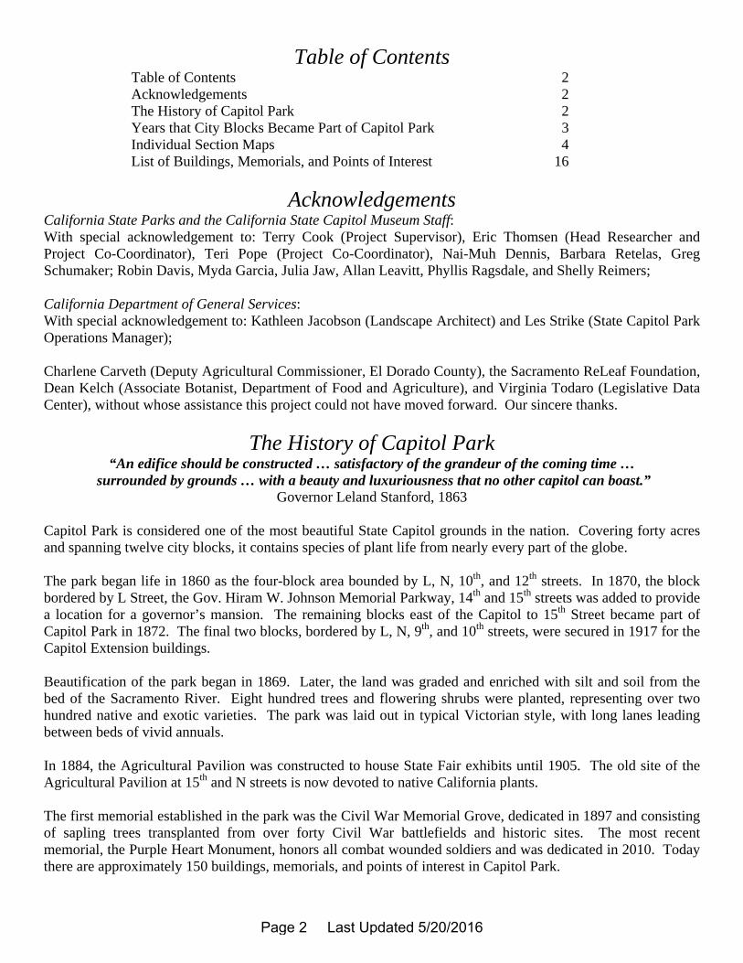
Table of Contents Table of Contents 2 Acknowledgements 2 The History of Capitol Park 2 Years that City Blocks Became Part of Capitol Park 3 Individual Section Maps 4 List of Buildings, Memorials, and Points of Interest 16
Acknowledgements
California State Parks and the California State Capitol Museum Staff: With special acknowledgement to: Terry Cook (Project Supervisor), Eric Thomsen (Head Researcher and Project Co-Coordinator), Teri Pope (Project Co-Coordinator), Nai-Muh Dennis, Barbara Retelas, Greg Schumaker; Robin Davis, Myda Garcia, Julia Jaw, Allan Leavitt, Phyllis Ragsdale, and Shelly Reimers; California Department of General Services: With special acknowledgement to: Kathleen Jacobson (Landscape Architect) and Les Strike (State Capitol Park Operations Manager); Charlene Carveth (Deputy Agricultural Commissioner, El Dorado County), the Sacramento ReLeaf Foundation, Dean Kelch (Associate Botanist, Department of Food and Agriculture), and Virginia Todaro (Legislative Data Center), without whose assistance this project could not have moved forward. Our sincere thanks.
The History of Capitol Park “An edifice should be constructed … satisfactory of the grandeur of the coming time …
surrounded by grounds … with a beauty and luxuriousness that no other capitol can boast.” Governor Leland Stanford, 1863
Capitol Park is considered one of the most beautiful State Capitol grounds in the nation. Covering forty acres and spanning twelve city blocks, it contains species of plant life from nearly every part of the globe. The park began life in 1860 as the four-block area bounded by L, N, 10th, and 12th streets. In 1870, the block bordered by L Street, the Gov. Hiram W. Johnson Memorial Parkway, 14th and 15th streets was added to provide a location for a governor’s mansion. The remaining blocks east of the Capitol to 15th Street became part of Capitol Park in 1872. The final two blocks, bordered by L, N, 9th, and 10th streets, were secured in 1917 for the Capitol Extension buildings. Beautification of the park began in 1869. Later, the land was graded and enriched with silt and soil from the bed of the Sacramento River. Eight hundred trees and flowering shrubs were planted, representing over two hundred native and exotic varieties. The park was laid out in typical Victorian style, with long lanes leading between beds of vivid annuals. In 1884, the Agricultural Pavilion was constructed to house State Fair exhibits until 1905. The old site of the Agricultural Pavilion at 15th and N streets is now devoted to native California plants. The first memorial established in the park was the Civil War Memorial Grove, dedicated in 1897 and consisting of sapling trees transplanted from over forty Civil War battlefields and historic sites. The most recent memorial, the Purple Heart Monument, honors all combat wounded soldiers and was dedicated in 2010. Today there are approximately 150 buildings, memorials, and points of interest in Capitol Park.
Page 2 Last Updated 5/20/2016

N
E
W
S
Capitol
UnruhOffice
Building
MoskLibrary
& CourtsBuilding
ServiceArea
RoseGarden
GrindingRock
15th Street
10th Street
9th Street
L Street
N S
treet
CapitolFountain
Plaza
2 South (East)1860 (p. 9)
2 North (East)1860 (p. 8)
2 South (West)1860 (p. 7)
2 North (West)1860 (p. 6)
1 South 1917(p. 5)
1 North 1917(p. 4)
3 South1872
(p. 11)
3 North1872
(p. 10)
4 South1872
(p. 13)
4 North1872
(p. 12)
5 South 1872(p. 15)
5 North 1870(p. 14)
Years that City BlocksBecame Part of Capitol Park
VietnamMemorial
CamelliaGrove
MemorialGrove
MoonTree
ElSoldado
Peace Officer’sMemorial
State Seals
FirefightersMemorial
VeteransMemorial
CactusGarden
CapitolKitty
FirefightersMemorial
VeteransMemorial
PeaceOfficer’sMemorial
VietnamMemorial andRose Garden
El Soldado
Civil WarMemorialGrove
In the early years, the Capitol was almost on the outskirts of town. Deer and cattle were seen wandering through the devel-oping park causing such problems that the park was fenced. A circular path was planted with alternating English Elm and California Fan Palms. It was used as a carriage path and a shady walk between the Capitol and Agricultural Pavilion. You can still trace much of the path with the remaining palm trees.
The last major park renovation coincided with the construc-tion of the Capitol annex, 1948-1951. Unfortunately, some heritage trees have been lost due to age and storm damage.
A stroll through this delightful park of historic buildings, me-morials, and points of interest is an occasion that lingers long in the memory of visitors. For the convenience of the histori-an, all buildings, memorials, and points of interest are labeled.
Use this pamphlet as a guide to the buildings, memori-als, and points of interest of Capitol Park. Please note that this park is susceptible to change. Items are re-moved due to disease, building projects, or accidents and are replaced pending availability and funding.
Page 3 Last Updated 5/20/2016
L Street
Capitol Mall
Jesse UnruhState Office
Building
9th Street
10th Street
Capitol Mall
Capitol Mall
Earl Warren Walk
R. Jones(markerremoved)
ElSoldado
Mosk
King
CapitolFountain
Plaza
PeaceOfficer’sMemorial
CapitolFountain
Plaza
Section 1 North
Section 1 North HighlightsSections 1 North and 1 South are relative newcomers to Capitol Park. In 1910, more state agencies were housed in San Francisco than Sacramento. Concerned about the growing movement to move the capital to San Francisco, Sacramento boosters began a movement to purchase these two blocks of land to allow for an expansion of the Capitol. Construction began on two buildings, known collectively as the Capitol Extension, in 1922, and the buildings were first occupied in 1928. The State Treasurer’s Office is now the sole tenant of State Office Building Number One, now named the Jesse Unruh State Office Building, in honor of one of the most influential Speakers of the California State Assembly. Between the two buildings sits Capitol Fountain Plaza, which was constructed and operating two years before the Capitol Extension was finished, and was soon considered “one of the beauty spots of the city.” To the southwest of the Unruh Building is the Earl Warren Walk, named in honor of the former Governor of California, one of the last to freely walk the streets of Sacramento. It marks the path he wore in the grass on his many lunchtime trips to the Sutter Club, just across 9th Street, of which he was a member. Ralphella Jones (1930-2002) worked for the Department of General Services in the Unruh Building from 1981 to 2002. El Soldado honors “American Service-men of Hispanic Descent And All Others Who Sacrificed Their Lives To Protect The Freedom We Enjoy.”
see p. 6
see facing page
Page 4 Last Updated 5/20/2016
N Street
Capitol Mall
Stanley MoskLibrary and
Courts Building
9th Street
10th Street
Capitol Mall
Mosk
MaleticPuglia
King
CapitolFountain
Plaza
PeaceOfficer’sMemorial
CapitolFountain
Plaza
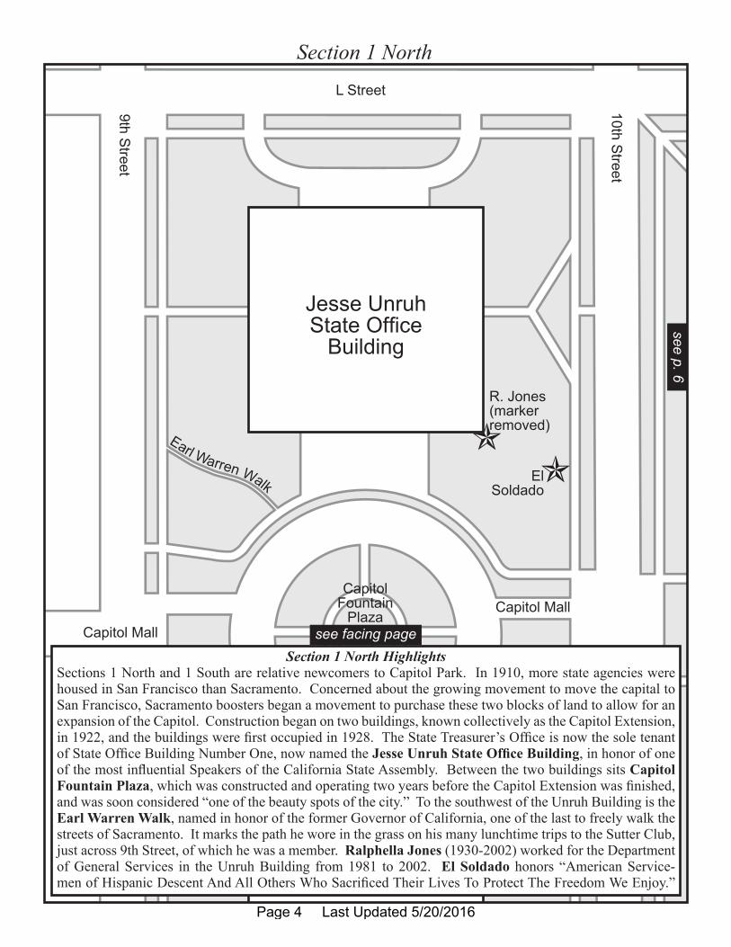
Section 1 South
Section 1 South HighlightsThe Stanley Mosk (1912-2001) Library and Courts Building honors the former state Attorney General and the longest-serving justice on the California State Supreme Court, which meets in this building. Near the entrance stands a statue dedicated to the “Guardian of The Law and Defender of Civil Rights and Civil Liberties.” At the northeast corner of this section stands the solemn California Peace Officer’s Memo-rial, dedicated to the more than 1,400 peace officers who have given their lives in the line-of-duty since California became a state in 1850. Three nine-foot bronze figures keep watch over the memorial: a county sheriff of the 1880s, a state trooper of the 1930s, and a city patrolman of the 1980s. Facing these is a life-sized sculpture of a grieving wife and child, noting “We honor those who also sacrificed.” Jim King (1968-1996): Sacramento police officer, missing and presumed drowned in Hawaii while on vacation with several friends and his fiancée. Robert Puglia (1929-2005): Presiding Justice of the 3rd District Court of Appeal (which meets in this building) for 24 years and author of over 400 opinions. Slobodan Ma-letic (1949-2002): A custodian for the Court of Appeal, Third Appellate District. He and his wife, also a custodian, were part of the court family, and together they served the court faithfully for over 40 years.
see facing pagesee p. 7
Page 5 Last Updated 5/20/2016
SecurityBarrier
L Street11thS
treet10th Street
WestEntrance
ElSoldado
Menorah(Seasonal)
Clay
CRHLNo. 872
Belotti
Murray
GraniteColumn
Section 2 North (West)
CapitolBuilding
Section 2 North (West) HighlightsThe four blocks bordered by L, N, 10th, and 11th streets were secured in 1860 for the construction of the California State Capitol. Ben and Nicole Clay of San Diego donated this Italian Stone Pine (Pinus pinea). Every year at Chanukah, a large Menorah is erected and lit. Each year since 1993, the Governor’s office has joined with Jewish community leaders for a ceremony to light it. The steel menorah was made in Sacramento and stands thirteen feet tall, nine feet wide, and weighs approximately half a ton. In 2006, it was painted by special needs children in Chabad of California’s Friendship Circle program. Califor-nia Registered Historical Landmark No. 872 is one of over 1,000 such markers denoting historic sites throughout California. It reads, in part, that the historic Capitol’s “design and construction are tributes to California’s pioneer architects, craftsmen and builders.” Next to it is the “Heritage ‘76” Plaque commemo-rating America’s bicentennial year of 1976. Both of these plaques are attached to a slab of granite, which itself is marked by a third plaque, declaring that the 2,400 pound slab once sealed the Capitol’s time capsule inside the cornerstone at the northeast corner of the building. It was moved to its present location in 1982, to “commemorate the close of California’s Bicentennial Restoration Project” of the State Capitol building.
see facing page
see
p. 4
see p. 8
Page 6 Last Updated 5/20/2016

SecurityBarrier
N Street
11thS
treet
10th Street
WestEntrance
King
Menorah(Seasonal)
Christmas Tree(Seasonal)
State Seals
Clay
Water WiseGardening
DemonstrationProject
Sher
McAteer
PeaceOfficer’sMemorial
GraniteColumn
Section 2 South (West)
CapitolBuilding
Section 2 South (West) HighlightsAnnually, a Christmas Tree is erected and decorated with ornaments made by developmentally disabled students. A new tree is cut each year from the Sierra Nevada mountains, and is lighted by the Governor and First Lady, accompanied by a disabled child. Just outside the west entrance are the large, bronze Great Seal of the State of California and the Native American and Spanish-Mexican commemorative seals. The Great Seal was placed here in 1952, and the others in 2002, to represent the contributions of Native Americans and Hispanics to the history and culture of California. In 2006, a Security Barrier was con-structed around the Capitol to improve building security after a 2001 incident, when a tractor trailer was deliberately crashed into the building, causing $19 million worth of damage. Ben and Nicole Clay donated a Deodar Cedar (Cedrus deodara) to replace a fallen original. The Water Wise Gardening Demonstra-tion Project, the result of a cooperative effort of several agencies, is meant to educate the public about the importance of wise water use and demonstrate that low-water gardens do not necessarily mean low-color or high-maintenance. In December 2002, one of the last original Italian Stone Pines, at least 131 years old and propped up by a metal post, fell and was removed, opening up a section of the park for this garden.
see facing pagese
e p.
5see p. 9
Page 7 Last Updated 5/20/2016
SecurityBarrier
L Street
11thS
treet
12thS
treet
NorthEntrance
SouthEntrance
EastEntrance Gov. Hiram W. Johnson
Haller
Crew & BonpuaGorman
Roosevelt
Cornerstone
Korfhage
Webster
Sistersof Mercy
GirlScouts
CivilWar
Purcell(markerremoved)
Dunphy
USC&GSCherry
Trees
King
Savannah
Grabell9-11Memorial
McKeownRose Bed
Belotti
CCC
MoonTree
Ohnimus
Z’berg
PrincetonAmerican Elm
Murray
Schwarzenegger
Section 2 North (East)
CapitolBuilding
Section 2 North (East) HighlightsJohn Pursell: Tree donated by friends and family. Civilian Conservation Corps (CCC): Tree planted for the 50th anniversary of the organization. Tierra Del Oro Girl Scout Council: Tree planted for the 80th anniversary of the Girl Scouts in the U.S. Franklin Roosevelt (1882-1945): Tree planted for the 100th anniversary of the birth of the 32nd President of the U.S. Wilbur Korfhage (1900-1987): Senate chaplain (1981-1986) and temperance advocate. Gilbert Murray (1948-1995): President of the Califor-nia Forestry Association. Edwin Z’berg (1926-1975): Sacramento Assemblyman (1958-1975). Capitol Cornerstone: Replacement of the 1861 original, placed in 1978. Moon Tree: As a seed, orbited the Moon aboard the comman module of the Apollo 14 mission. Frank Belotti (1898-1972): North Coast Assembly-man (1950-1973). Sisters of Mercy: Arriving in Sacramento in 1857, their mission to care for the sick, poor, elderly, and uneducated continues today. Arlyn Webster (1937-1998): Co-founder of the State Coalition of Probation Organizations and past president of the California Probation Parole Corrections Association. Arthur Ohnimus (1893-1965): Longest serving Assembly chief clerk (1923-1937, 1941-1963). Califor-nia Civil War Veterans: Dedicated on the 100th anniversary of the war to the State’s veterans. Angela Crew (1951-1999): Staff support specialist for the State Legislature. Charmette Bonpua (1965-2010): Chief of staff to Speakers Wesson and Nuñez. Martha Gorman (1941-1996): Legislative administrative assistant, legal counsel, and advocate. 9-11 Memorial: Placed on the one-year anniversary of the attack.
see facing page
see p. 10see
p. 6
Page 8 Last Updated 5/20/2016
SecurityBarrier
N Street11thS
treet
12thS
treet
SouthEntrance
EastEntrance Gov. Hiram W. Johnson
Haller
Crew & BonpuaGorman
Dunphy
USC&GSCherry
Trees
Greene(removed)
CapitolKitty
SpanishWar Veterans
9-11Memorial
McKeownRose Bed
Sher
McAteer
Schwarzenegger
Section 2 South (East) HighlightsMayron “Mac” McKeown Rose Bed: Dedicated by female legislators to the man who gave them, once a month for over two decades, a rose to remind them of their importance in bringing issues vital to women to the forefront in the male-dominated Capitol. Arnold Schwarzenegger (b. 1947): Governor (2003-2011). Marie Dunphy (1926-1996): Wife of Dean Dunphy, Secretary of Business, Transportation, and Hous-ing under Governor Wilson. This tree is near the site where, in July 1945, Marie promised to marry Dean. Cherry Trees: One was donated by the Japan Business Association of Southern California and the Japanese Chamber of Commerce of Northern California. The second was planted in honor of the 50th anniversary of the Treaty of Peace with Japan, signed in 1951. The last three were a gift of Governor Knock Yokoyama of Osaka Prefecture, Japan. USC&GS: A survey disk placed by the United States Coast and Geodetic Survey in 1907 to aid in mapping the country. Byron Sher (b. 1928): Honors the environmental leadership of the South Bay Assemblyman (1981-1997) and Senator (1997-2005). Capitol Kitty (1991-2004): Beloved feline resident of Capitol Park, sometimes referred to as ‘Senator’ and the subject of her own book written by First Lady Sharon Davis. J. Eugene McAteer (1916-1967): World War II Naval veteran and San Fran-cisco State Senator (1959-1967). Denny Greene (1919-1991): Wife of State Assemblyman and Senator Leroy Greene (1918-2002), well-known for sending out hundreds of letters to her husband’s constituents.
Section 2 South (East)
CapitolBuilding
see facing pagese
e p.
5see p. 9
Page 9 Last Updated 5/20/2016
Carriage Route (approximate)
Security Barrier
Gov. Hiram W. Johnson
ServiceYard
L Street
12thS
treet
13thS
treet
Insectary
Restrooms
MemorialJohnsonGov. Hiram W. Parkway
Serra
El CaminoReal Bell
Moretti
SnodgrassMaddy Kellogg
Hawk
Sundial
ReissBolton
HallerPrincetonAmericanElm
Gorman
CivilWar
PioneerCamelliaGrove Marker
Smith
Randall
E. Jones
World War IMemorial Trees
RedondoKing
FiveForks
McKinley’sTombSavannah
Chattanooga
Liberty Bell
GrabellSpanish
War Veterans
USS California Bell
Civil WarMemorial Grove
Fish Pond
FirefightersMemorial
9-11Memorial
PrincetonAmerican Elm
Podesto(marker
removed)
Section 3 North
Section 3 North HighlightsPioneer Camellia Grove: A living memorial to the pioneers of the city and county of Sacramento. David (1911-2002) and Alice (1913-2003) Podesto: Married for 55 years. Junipero Serra (1713-1784): Father of the California mission system. El Camino Real Bell: One of hundreds of such bells that mark the old King’s Highway and other historic sites. Will Smith (1968-2010): Chief of staff to Senator George Runner and Assemblywoman Sharon Runner. James Randall (1937-2005): Twenty-six time chairman of Sacramento’s annual Camellia Show. Thomas Starr King (1824-1864): Tireless advocate of racial jus-tice, his efforts helped keep California in the Union during the Civil War. Clem Redondo (1908-1996): Long-time resident of Sacramento remembered with a flower bed, part of the Capitol Park Color Donation Program. Civil War Memorial Grove: Trees transplanted as saplings from Civil War sites, including Five Forks, VA, Savannah, GA, Chattanooga, TN, and the tomb of President McKinley in Canton, OH. The first memorial (1897) in the park. Spanish War Veterans: In honor of those who fought in the Spanish-American War (1898). Fish Pond: Peaceful, tree-enshrouded refuge for state workers and park visitors. Alice Grabell (1956-2006): She lived her life to the fullest. USS California Bell: From the only dread-nought-type battleship built on the Pacific Coast. Liberty Bell: This exact replica of the original made a 1950 statewide tour as part of a savings bond drive. WWI Memorial Trees: Honor the unknown first Cali-fornia soldier to die in that conflict. Everett Jones (1926-2005): Capitol building manager (1979-1987).
see facing page
see
p. 8
see p. 12
Page 10 Last Updated 5/20/2016
Carriage Route (approximate)
Security Barrier
Gov. Hiram W. Johnson
N Street
12thS
treet
13thS
treetMemorialJohnsonGov. Hiram W. Parkway
Moretti
SnodgrassMaddy Kellogg
Hawk
Sundial
Reiss Bolton
Ruffner
Soria
ShalineDeukmejian
Rolph
Los AngelesTree CalTrans
Herota
PALS
HallerPrincetonAmericanElm
Gorman
CivilWar
Greene(removed)
Civil WarMemorial Grove
FirefightersMemorial
GrindingRock
9-11Memorial
Bendix
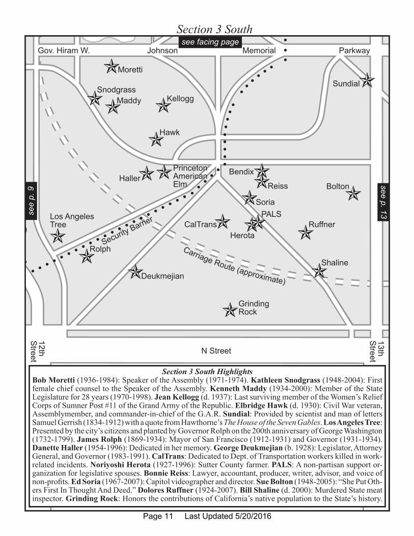
Section 3 South
Section 3 South HighlightsBob Moretti (1936-1984): Speaker of the Assembly (1971-1974). Kathleen Snodgrass (1948-2004): First female chief counsel to the Speaker of the Assembly. Kenneth Maddy (1934-2000): Member of the State Legislature for 28 years (1970-1998). Jean Kellogg (d. 1937): Last surviving member of the Women’s Relief Corps of Sumner Post #11 of the Grand Army of the Republic. Elbridge Hawk (d. 1930): Civil War veteran, Assemblymember, and commander-in-chief of the G.A.R. Sundial: Provided by scientist and man of letters Samuel Gerrish (1834-1912) with a quote from Hawthorne’s The House of the Seven Gables. Los Angeles Tree: Presented by the city’s citizens and planted by Governor Rolph on the 200th anniversary of George Washington (1732-1799). James Rolph (1869-1934): Mayor of San Francisco (1912-1931) and Governor (1931-1934). Danette Haller (1954-1996): Dedicated in her memory. George Deukmejian (b. 1928): Legislator, Attorney General, and Governor (1983-1991). CalTrans: Dedicated to Dept. of Transportation workers killed in work-related incidents. Noriyoshi Herota (1927-1996): Sutter County farmer. PALS: A non-partisan support or-ganization for legislative spouses. Bonnie Reiss: Lawyer, accountant, producer, writer, advisor, and voice of non-profits. Ed Soria (1967-2007): Capitol videographer and director. Sue Bolton (1948-2005): “She Put Oth-ers First In Thought And Deed.” Dolores Ruffner (1924-2007). Bill Shaline (d. 2000): Murdered State meat inspector. Grinding Rock: Honors the contributions of California’s native population to the State’s history.
see facing pagese
e p.
9see p. 13
Page 11 Last Updated 5/20/2016
Carriage Route (approximate)ServiceYard
L Street
13thS
treet
14thS
treet
Memorial Parkway
Insectary
Restrooms
MemorialJohnsonGov. Hiram W. Parkway
Randall
E. Jones
Valley ForgeAmerican Elm
DavisSullaway
Gregory
Cooper
Ela
Heritage MissionOlive Tree
Tullos
Wilson& Oki
FirefightersMemorial
NativePlantGarden
California Federation
of Women’s Clubs(marker removed)
McNeil-Lucas
Grimes
Maathai
Grund
M. Frost
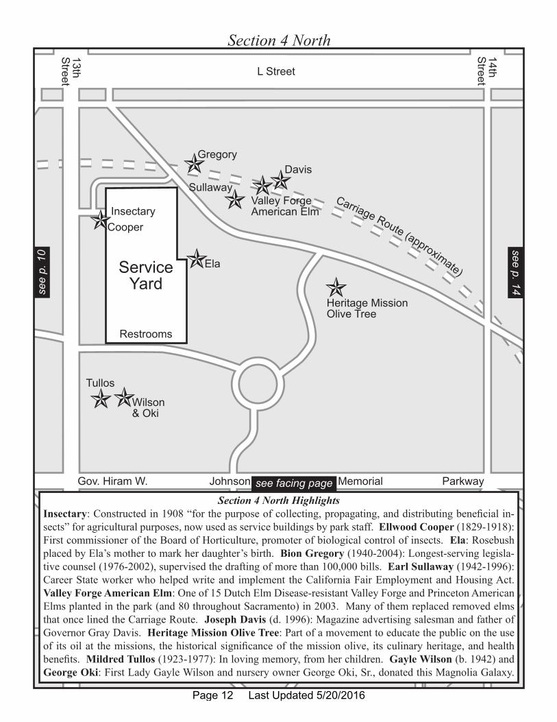
Section 4 North
Section 4 North HighlightsInsectary: Constructed in 1908 “for the purpose of collecting, propagating, and distributing beneficial in-sects” for agricultural purposes, now used as service buildings by park staff. Ellwood Cooper (1829-1918): First commissioner of the Board of Horticulture, promoter of biological control of insects. Ela: Rosebush placed by Ela’s mother to mark her daughter’s birth. Bion Gregory (1940-2004): Longest-serving legisla-tive counsel (1976-2002), supervised the drafting of more than 100,000 bills. Earl Sullaway (1942-1996): Career State worker who helped write and implement the California Fair Employment and Housing Act. Valley Forge American Elm: One of 15 Dutch Elm Disease-resistant Valley Forge and Princeton American Elms planted in the park (and 80 throughout Sacramento) in 2003. Many of them replaced removed elms that once lined the Carriage Route. Joseph Davis (d. 1996): Magazine advertising salesman and father of Governor Gray Davis. Heritage Mission Olive Tree: Part of a movement to educate the public on the use of its oil at the missions, the historical significance of the mission olive, its culinary heritage, and health benefits. Mildred Tullos (1923-1977): In loving memory, from her children. Gayle Wilson (b. 1942) and George Oki: First Lady Gayle Wilson and nursery owner George Oki, Sr., donated this Magnolia Galaxy.
see facing page
see p. 14see
p. 1
0
Page 12 Last Updated 5/20/2016
Carriage Route (approximate)
Carriage R
oute
(approximate)
N Street13thS
treet
14thS
treetMemorial Parkway MemorialJohnsonGov. Hiram W. Parkway
Bolton
Ruffner
Shaline
E. Jones
VeteransMemorial
FirefightersMemorial
NativePlantGarden
California Federation of Women’s Clubs(marker removed)
McNeil-Lucas
Grimes
SpencerMelton
Rico
Purple Heart
Maathai
Grund
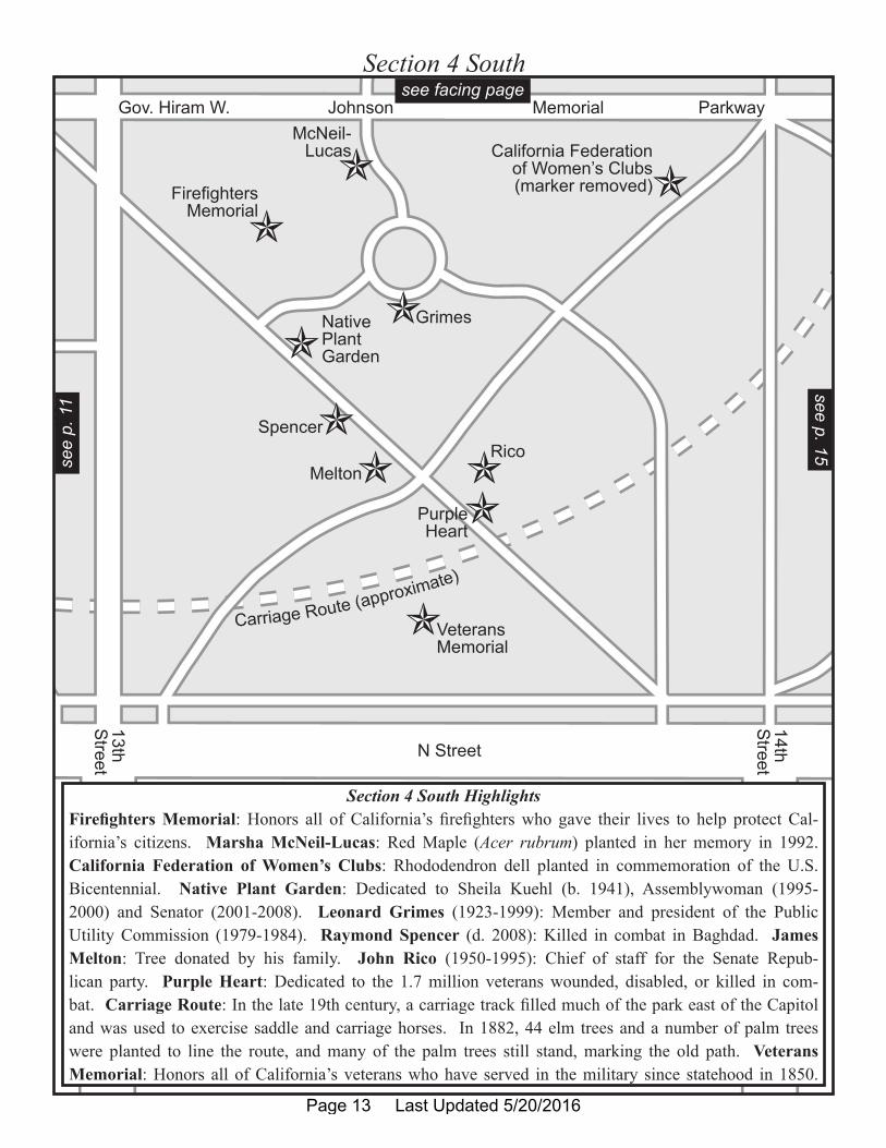
Section 4 South
Section 4 South HighlightsFirefighters Memorial: Honors all of California’s firefighters who gave their lives to help protect Cal-ifornia’s citizens. Marsha McNeil-Lucas: Red Maple (Acer rubrum) planted in her memory in 1992. California Federation of Women’s Clubs: Rhododendron dell planted in commemoration of the U.S. Bicentennial. Native Plant Garden: Dedicated to Sheila Kuehl (b. 1941), Assemblywoman (1995-2000) and Senator (2001-2008). Leonard Grimes (1923-1999): Member and president of the Public Utility Commission (1979-1984). Raymond Spencer (d. 2008): Killed in combat in Baghdad. James Melton: Tree donated by his family. John Rico (1950-1995): Chief of staff for the Senate Repub-lican party. Purple Heart: Dedicated to the 1.7 million veterans wounded, disabled, or killed in com-bat. Carriage Route: In the late 19th century, a carriage track filled much of the park east of the Capitol and was used to exercise saddle and carriage horses. In 1882, 44 elm trees and a number of palm trees were planted to line the route, and many of the palm trees still stand, marking the old path. Veterans Memorial: Honors all of California’s veterans who have served in the military since statehood in 1850.
see facing pagesee p. 15
see
p. 1
1
Page 13 Last Updated 5/20/2016
Carriage R
oute
(approximate)
Carri
age
Rou
te(a
ppro
ximat
e)
AgriculturalPavilion
(approximate)
Gov. Hiram W. Johnson Memorial Parkway
L Street
CapitolAvenue
14thS
treet 15th Street
MemorialJohnsonGov. Hiram W. Parkway
Heritage MissionOlive Tree
VietnamVeteransMemorial
WorldPeaceRose
Garden
CactusGarden
California Federation of Women’s Clubs(marker removed)
Maathai
Hernandez
Wheaton
Grund
M. Frost
McGinness
I. & T.Frost
K. & E.Frost
PrincetonAmerican Elm
SamuelCollins
Otto PeacePavilion
BC
D
EL
GH
A
IJ
K
F
M
NO P
Q
R
S
Fountain
C a l i f o r n i a
N a t i v e
P l a n t
S e c t i o n
Governor’s Mansion(approximate)
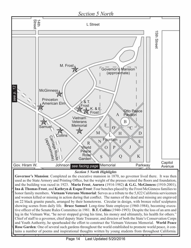
Section 5 North
Section 5 North HighlightsGovernor’s Mansion: Completed as the executive mansion in 1870, no governor lived there. It was then used as the State Armory and Printing Office, but the weight of the presses ruined the floors and foundation, and the building was razed in 1923. Maria Frost, Aurora (1914-1982) & G.G. McGinness (1910-2001), Ina & Thomas Frost, and Kathryn & Esque Frost: Four benches placed by the Frost/McGinness families to honor family members. Vietnam Veterans Memorial: Serves as a tribute to the 5,822 California servicemen and women killed or missing in action during that conflict. The names of the dead and missing are engraved on 22 black granite panels, arranged by their hometowns. Circular in design, with bronze relief sculptures showing scenes from daily life. Bruce Samuel: Long-time State employee (1960-1984), becoming execu-tive officer of the Senate Rules Committee in 1981. B.T. Collins (1940-1993): Despite the loss of an arm and leg in the Vietnam War, “he never stopped giving his time, his money and ultimately, his health for others.” Chief of staff to a governor, chief deputy State Treasurer, and director of both the State’s Conservation Corps and Youth Authority, he spearheaded the effort to construct the Vietnam Veterans Memorial. World Peace Rose Garden: One of several such gardens throughout the world established to promote world peace, it con-tains a number of poems and inspirational thoughts written by young students from throughout California.
see facing page
see
p. 1
2
Page 14 Last Updated 5/20/2016
Carri
age
Rou
te(a
ppro
ximat
e)
AgriculturalPavilion
(approximate)
Gov. Hiram W. Johnson
N Street
Capitol Avenue
14thS
treet
15th Street
MemorialJohnsonGov. Hiram W. Parkway
CactusGarden
Maathai
Hernandez
Wheaton
Grund
Ferguson
Warner
KQS
C a l i f o r n i a
N a t i v e
P l a n t
S e c t i o n
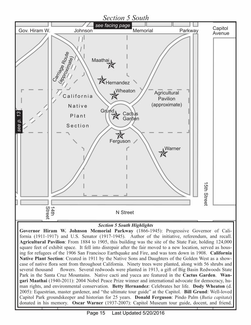
Section 5 South
Section 5 South HighlightsGovernor Hiram W. Johnson Memorial Parkway (1866-1945): Progressive Governor of Cali-fornia (1911-1917) and U.S. Senator (1917-1945). Author of the initiative, referendum, and recall.Agricultural Pavilion: From 1884 to 1905, this building was the site of the State Fair, holding 124,000 square feet of exhibit space. It fell into disrepair after the fair moved to a new location, served as hous-ing for refugees of the 1906 San Francisco Earthquake and Fire, and was torn down in 1908. California Native Plant Section: Created in 1911 by the Native Sons and Daughters of the Golden West as a show-case of native flora sent from throughout California. Ninety trees were planted, along with 56 shrubs and several thousand flowers. Several redwoods were planted in 1913, a gift of Big Basin Redwoods State Park in the Santa Cruz Mountains. Native cacti and yucca are featured in the Cactus Garden. Wan-gari Maathai (1940-2011): 2004 Nobel Peace Prize winner and international advocate for democracy, hu-man rights, and environmental conservation. Betty Hernandez: Celebrates her life. Dody Wheaton (d. 2005): Equestrian, master gardener, and “the ultimate tour guide” at the Capitol. Bill Grund: Well-loved Capitol Park groundskeeper and historian for 25 years. Donald Ferguson: Pindo Palm (Butia capitata) donated in his memory. Oscar Warner (1937-2007): Capitol Museum tour guide, docent, and friend.
see facing pagese
e p.
13
Page 15 Last Updated 5/20/2016
List of Buildings, Memorials, and Points of Interest Found in Capitol Park
PLEASE NOTEMany locations of items in Section 5N are followed by (R/--), with the dash being a letter from A to S. This stands for specific subsections within the World Peace Rose Garden. See the map of Section 5N.
Name Date Location Coordinates9-11 / September 11, 2001, Memorial
September 11, 2002 2N 38°34.584'N 121°29.543'W
Agricultural Pavilion (removed) Completed Jan. 22, 1884, demolished Nov. 9, 1908
5S 38°34.489'N 121°29.335'W
American Elms, Princeton and Valley Forge
September 2003 3N, 3S, 4N, 4S, 5N
See “Notes” Section
Belotti, Assemblyman Frank P. September 5, 1973 2N 38°34.626'N 121°29.577'W
Bendix, Carl December 16, 2010 3S 38°34.536'N 121°29.485'W
Bolton, Sue 2005 3S 38°34.529'N 121°29.459'W
Brazill, Diane M. 2003 5N (R/R) 38°34.530'N 121°29.312'W
California Civil War Veterans May 30, 1963 2N 38°34.578'N 121°29.537'W
California Coalition Against Sexual Assault (CALCASA)
2003 5N (R/A) 38°34.526'N 121°29.300'W
California Department of Transportation Highway Workers
2005 3S 38°34.516'N 121°29.493'W
California Federation of Women’s Clubs United States Bicentennial Rhododendron Dell (marker removed)
May 1976 4S 38°34.512'N 121°29.361'W
California Firefighters Memorial April 6, 2002 4S 38°34.536'N 121°29.430'W
California Native Plant Section 1911 5S (Entire) 38°34.489'N 121°29.335'W
California Peace Officer’s Memorial May 17, 1988 1S 38°34.615'N 121°26.725'W
California Registered Historical Landmark No. 872
1982 2N, 2S 38°34.612'N 121°29.663'W
California State Capitol 1860-74 (original), 1976-82 (last renovation)
2N, 2S 38°34.592'N 121°29.592'W
California State Employees Association Local 1000, SEIU, AFL-CIO, CLC Civil Service Division
2003 5N (R/S) 38°34.518'N 121°29.285'W
California State Employees Association, Civil Service Division
2003 5N (R/Q) 38°34.526'N 121°29.311'W
California Veterans Memorial December 12, 1998 4S 38°34.495'N 121°29.418'W
Page 16 Last Updated 5/20/2016

Name Date Location CoordinatesCalifornia Vietnam Veterans Memorial
December 10, 1988 5N 38°34.542'N 121°29.320'W
Capitol Christmas Tree Annually at Christmas time 2N 38°34.611'N 121°29.671'W
Capitol Cornerstone 1861 (original), 1978 (new) 2N 38°34.602'N 121°29.592'W
Capitol Fountain Plaza 1925 1N, 1S 38°34.632'N 121°29.731'W
Capitol Menorah Annually at Chanukah season
2N 38°34.607'N 121°29.642'W
Carriage Route (removed) 1882 3N, 3S, 4N, 4S, 5N, 5S
38°34.515'N 121°29.484'W
Catholic Schools of California 2003 5N (R/J) 38°34.524'N 121°29.285'W
Chavez, Cesar 2003 5N (R/A) 38°34.518'N 121°29.285'W
Chaw’se Native American Grinding Rock
ca. 1968 3S 38°34.511'N 121°29.501'W
Cherry Trees, Grouping of Five July 1997 and June 7, 2001 2S 38°34.563'N 121°29.554'W
Civil War Memorial Grove May 1, 1897 3N 38°34.572'N 121°29.500'W
Civilian Conservation Corps Anniversary Marker
April 14, 1983 2N 38°34.643'N 121°29.574'W
Clay, Ben and Nikki Unknown 2N 38°34.662'N 121°29.663'W
Clay, Nicole and Ben 2008 2S 38°34.568'N 121°29.689'W
Collins, B.T. 1993 or later 5N 38°34.543'N 121°29.324'W
Cooper, Ellwood 1907 4N 38°34.595'N 121°29.410'W
Crew, Angela and Charmette Bonpua
1999 or later (original), January 2011 (new)
2N 38°34.594'N 121°29.560'W
David, T.J. “the Rose Man” 2003 5N (R/G) 38°34.530'N 121°29.297'W
Davis, Joseph Graham Sr. August 12, 1997 4N 38°34.585'N 121°29.372'W
Deukmejian, George September 2008 3S 38°34.523'N 121°29.529'W
Dowdell Grandchildren 2003 5N (R/I) 38°34.530'N 121°29.298'W
Dunphy, Marie Kiene May 1997 2S 38°34.569'N 121°29.557'W
El Camino Real Commemorative Bell
August 17, 2000 3N 38°34.599'N 121°29.472'W
El Soldado Tribute to Mexican American Soldiers of World War II
1951, moved here September 16, 1976
1N 38°34.644'N 121°29.699'W
Ela January 12, 2008 4N 38°34.574'N 121°29.391'W
Elm Research Institute (marker removed)
Unknown 3S Unknown
Ferguson, Donald November 1996 5S 38°34.485'N 121°29.338'W
Page 17 Last Updated 5/20/2016

Name Date Location CoordinatesFirst Ladies of California (marker removed)
Unknown 5N 38°34.529'N 121°29.308'W
Fish Pond Built 1940s; expanded 1949; redesigned 1984
3N 38°34.575'N 121°29.518'W
Frost, Ina K. & Thomas A. Unknown 5N 38°34.543'N 121°29.312'W
Frost, Kathryn L. & Esque Unknown 5N 38°34.541'N 121°29.306'W
Frost, Maria S. Unknown 5N 38°34.569'N 121°29.315'W
Gorman, Martha C. Unknown 2N 38°34.593'N 121°29.554'W
Governor's Mansion/Printing Plant/Armory (removed)
Began Aug. 26, 1870, demolished Nov. 24, 1923
5N 38°34.555'N 121°29.298'W
Grabell, Alice “Ali” Kikuchi 2006 or later 3N 38°34.578'N 121°29.500'W
Great Seal of the State of California, The
October 1952 2S, 2N 38°34.606'N 121°29.642'W
Greene, Denny (marker removed) 1991 2S 38°34.550'N 121°29.574'W
Gregory, Bion M. 2004 4N 38°34.591'N 121°29.388'W
Grimes, Leonard M., Jr. 1999 or later 4S 38°34.522'N 121°29.410'W
Grund, Bill ca. 1990s 5S 38°34.489'N 121°29.335'W
Gurevitz, Liv and Caroly Carmody 2003 5N (R/F) 38°34.518'N 121°29.285'W
Haller, Danette M. 1996 or later 3S 38°34.542'N 121°29.528'W
Harlan, Jean A. 2003 5N (R/N) 38°34.529'N 121°29.308'W
Hawk, Elbridge L. May 11, 1931 3S 38°34.553'N 121°29.514'W
Heritage Mission Olive Tree 2006 4N 38°34.571'N 121°29.365'W
Hernandez, Betty Jean 2009 5S 38°34.483'N 121°29.328'W
Herota, Noriyoshi Rosh 1996 or later 3S 38°34.517'N 121°29.494'W
HLA Group Landscape Architects, The, & Planners John H. Nicolaus, ASLA
2003 5N (R/O) 38°34.525'N 121°29.303'W
Hmong “Freedom Fighter” Veterans 2003 5N (R/M) 38°34.531'N 121°29.307'W
Hmong, Lao, Mien Communities 2003 5N (R/F) 38°34.535'N 121°29.298'W
Insectary December 2, 1908 4N 38°34.593'N 121°29.407'W
Johnson, Governor Hiram W., Memorial Parkway
1986 3N, 3S, 4N, 4S, 5N, 5S
38°34.591'N 121°29.507'W; 38°34.510'N 121°29.322'W
Jones, Everett P. 2000 or later 3N 38°34.577'N 121°29.485'W
Jones, Ralphella (marker removed) 2009 1N 38°34.655'N 121°29.712'W
Page 18 Last Updated 5/20/2016
Name Date Location CoordinatesKasimatis, Kaitlin Noelle (marker removed)
1996 or later 3S Unknown
KCRA-TV 2003 5N (R/M) 38°34.536'N 121°29.304'W
Kellogg, Jean A. Bell Unknown 3S 38°34.555'N 121°29.511'W
King, Jim 1996 1S 38°34.589'N 121°29.717'W
King, Thomas Starr November 2009 3N 38°34.603'N 121°29.478'W
Korfhage, Reverend Wilbur A. 1987 or later 2N 38°34.647'N 121°29.536'W
KTXL Fox 40 2003 5N (R/P) 38°34.526'N 121°29.300'W
Kuehl, Senator Sheila James, Native Plant Garden
August 19, 2008 4S 38°34.513'N 121°29.426'W
Lesbian, Gay, Bisexual and Transgendered Families
2003 5N (R/R) 38°34.529'N 121°29.316'W
Liberty Bell (Reproduction) 1950, moved here 1957 3N 38°34.568'N 121°29.499'W
Los Angeles Tree February 22, 1932 3S 38°34.535'N 121°29.552'W
Maathai, Wangari Unknown 5S 38°34.507'N 121°29.327'W
Maddy, Kenneth 2000 or later 3S 38°34.564'N 121°29.518'W
Maletic, Slobodan 2002 1S 38°34.568'N 121°29.769'W
McAteer, Sen. J.E. 1967 2S 38°34.548'N 121°29.587'W
McGinness, Aurora M. & G.G. 2001 or later 5N 38°34.557'N 121°29.321'W
McKeown, Mayron “Mac” (the “Rose Man”)
August 2007 2S 38°34.563'N 121°29.554'W
McNeil-Lucas, Marsha October 28, 1992 4S 38°34.529'N 121°29.416'W
Melton, James R. Unknown 4S 38°34.498'N 121°29.425'W
Moon Tree, Apollo 14 1976 2N 38°34.606'N 121°29.569'W
Moretti, Bob 1994 3S 38°34.574'N 121°29.518'W
Mosk, Stanley November 6, 2002 1S 38°34.613'N 121°29.751'W
Mosk, Stanley, Library and Courts Building
1928 1S 38°34.590'N 121°29.752'W
Murray, Gilbert April 28, 1998 2N 38°34.634'N 121°29.575'W
Muslim Community of Greater Sacramento
2003 5N (R/H) 38°34.527'N 121°29.292'W
Native American Commemorative Seal
May 28, 2002 2N 38°34.600'N 121°29.635'W
Nicolas, Leonida A. 2003 5N (R/C) 38°34.522'N 121°29.295'W
Ohnimus, Arthur A. 1973 2N 38°34.617'N 121°29.560'W
Otto, John F. (John F. Otto, Inc.) 2003 5N (R/H) 38°34.518'N 121°29.285'W
Page 19 Last Updated 5/20/2016
Name Date Location CoordinatesPALS 2006 3S 38°34.518'N 121°29.486'W
Pieretti, Frank & Ida 2003 5N (R/A) 38°34.533'N 121°29.296'W
Pioneer Camellia Grove Dedicated March 8, 1942, Expanded 1946 and 1953
3N 38°34.609'N 121°29.485'W
Podesto, David & Alice (marker removed)
2003 or later 3N 38°34.609'N 121°29.485'W
Puglia, Robert K. 2005 1S 38°34.569'N 121°29.725'W
Purple Heart Monument August 7, 2010 4S 38°34.497'N 121°29.412'W
Pursell, John Alec (marker removed) Replaced 2009 2N 38°34.642'N 121°29.578'W
Randall, James M. 2005 or later 3N 38°34.597'N 121°29.468'W
Redondo, Clemente (Clem) June 18, 1996 3N 38°34.589'N 121°29.481'W
Reiss, Bonnie Unknown 3S 38°34.533'N 121°29.485'W
Rico, John 1995 4S 38°34.505'N 121°29.411'W
Rolph, James Jr. September 9, 1934 3S 38°34.532'N 121°29.539'W
Roosevelt, Franklin D., Anniversary Memorial
February 1, 1982 2N 38°34.637'N 121°29.546'W
Ruffner, Dolores Johnson 2009 3S 38°34.512'N 121°29.715'W
Sacramento Interfaith Community 2003 5N (R/J) 38°34.525'N 121°29.293'W
Salvation Army 100th Anniversary in Sacramento
January 4, 1985 5S (possibly)
Samuel, Bruce 2003 5N 38°34.544'N 121°29.347'W
Schwarzenegger, Governor Arnold, Oak Tree
December 2010 2S 38°34.556'N 121°29.551'W
Security Barriers 2006 2S, 2N, 3S, 3N
See “Notes” Section
Senator Capitol Kitty 2004 2S 38°34.556'N 121°29.589'W
Serra, Father Junipero Placed 1965, dedicated April 8, 1967
3N 38°34.597'N 121°29.476'W
Shaline, Bill 2001 3S 38°34.509'N 121°29.478'W
Sher, Senator Byron D. 2004 2S 38°34.564'N 121°29.606'W
Sisters of Mercy Memorial June 29, 2007 2N 38°34.614'N 121°29.572'W
Smith, Will August 5, 2010 3N 38°34.598'N 121°29.450'W
Snodgrass, Kathleen J. 2004 3S 38°34.558'N 121°29.526'W
Soria, Ed March 2009 3S 38°34.526'N 121°29.487'W
Spanish War Veterans June 14, 1949 3N 38°34.575'N 121°29.518'W
Page 20 Last Updated 5/20/2016

Name Date Location CoordinatesSpanish-Mexican Commemorative Seal
May 28, 2002 2S 38°34.597'N 121°29.635'W
Spencer, SPC Raymond N. Jr. 2008 4S 38°34.510'N 121°29.423'W
St. Francis High School 2003 5N (R/J) 38°34.518'N 121°29.285'W
Sullaway, Earl L. 1996 or later 4N 38°34.584'N 121°29.388'W
Sundial 1910 3S 38°34.549'N 121°29.442'W
Tierra Del Oro Girl Scout Council 80th Anniversary
March 12, 1992 2N 38°34.640'N 121°29.552'W
Tullos, Mildred A. 1977 or later 4N 38°34.560'N 121°29.426'W
United States Coast & Geodetic Survey Marker
1888 2S 38°34.559'N 121°29.550'W
Unruh, Jesse, State Office Building (Treasury)
1928 1N 38°34.672'N 121°29.715'W
USS California Bell October 27, 1949 3N 38°34.571'N 121°29.508'W
Villalobos, Sylvia 2003 5N (R/G) 38°34.530'N 121°29.297'W
Warner, Oscar 2008 5S 38°34.477'N 121°29.317'W
Warren, Earl, Walk ca. 1940s 1N 38°34.647'N 121°29.741'W
Water Wise Gardening Demonstration Project
2003 2S 38°34.565'N 121°29.703'W
WE Edible Garden (removed) May 21, 2009 4N 38°34.551'N 121°29.397'W
Webster, Arlyn E. 1998 or later 2N 38°34.607'N 121°29.567'W
Wheaton, Dody 2006 5S 38°34.497'N 121°29.335'W
Wilson, Mrs. Pete and George Oki Sr.
October 27, 1992 4N 38°34.559'N 121°29.422'W
World Peace Rose Garden and Welcome Arch
2003 5N (R/E) 38°34.518'N 121°29.285'W
World Peace Rose Garden Carl R. Otto Peace Pavilion
2003 5N (R/B) 38°34.529'N 121°29.292'W
World Peace Rose Garden Dedication Plaque
2003 5N (R/Q) 38°34.518'N 121°29.285'W
World Peace Rose Garden Fountain 2003 5N (R/L) 38°34.529'N 121°29.302'W
World Peace Rose Garden Hmong Welcome Arch
2003 5N (R/F) 38°34.536'N 121°29.305'W
World Peace Rose Garden Horangic Family Welcome Arch
2003 5N (R/Q) 38°34.520'N 121°29.309'W
World Peace Rose Garden Student Poetry
2003 5N (Entire Rose Garden)
38°34.531'N 121°29.302'W
Page 21 Last Updated 5/20/2016
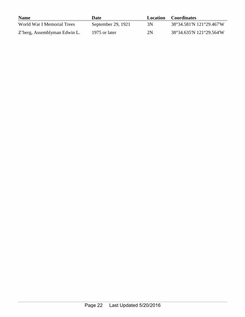
Name Date Location CoordinatesWorld War I Memorial Trees September 29, 1921 3N 38°34.581'N 121°29.467'W
Z’berg, Assemblyman Edwin L. 1975 or later 2N 38°34.635'N 121°29.564'W
Page 22 Last Updated 5/20/2016