
CALIFORNIA SALTWATER - · PDF fileSALTWATERCALIFORNIA SPORT FISHING REGULATIONS...
76
CALIFORNIA SALTWATER SPORT FISHING REGULATIONS 2017–2018 For Ocean Sport Fishing in California Effective March 1, 2017 through February 28, 2018
Transcript of CALIFORNIA SALTWATER - · PDF fileSALTWATERCALIFORNIA SPORT FISHING REGULATIONS...

CALIFORNIA
SALTWATERSPORT FISHING REGULATIONS
2017–2018
For Ocean Sport Fishing in CaliforniaEffective March 1, 2017 through February 28, 2018

The Fish and Game Commission is composed of five members appointed by the Governor and confirmed by the State Senate. The Commission sets hunting and sport fishing regulations including seasons, bag limits, methods, and areas of take. In addition, the Commission formulates general policies for the Department of Fish and Wildlife and regulates aspects of commercial fishing. Monthly topical meetings are held to hear regulation change proposals. The public may make recommendations in writing before a Commission meeting or present its proposals verbally at the meeting. The Commission’s meeting schedule, including specific topics, dates and locations, is posted on their website www.fgc.ca.gov. Written comments can be directed to the Fish and Game Commission at 1416 Ninth Street, Room 1320, Sacramento, CA 95814, or by e-mail to [email protected].
Alternate communication formats are available upon request. If reasonable accommodation is needed call CDFW at (916) 322-8911. The California Relay Service for the deaf or hearing-impaired can be utilized from TDD phones at (800) 735-2929.
Products or services provided by advertisers are not promoted or endorsed by the California Department of Fish and Wildlife.
What’s New for 2017? ............................................................. 4License Information ................................................................ 5Sport Fishing License Fees ..................................................... 8Keeping Up With In-Season Groundfish Regulation Changes .... 11 Map of Groundfish Management Areas ...................................12Summaries of Recreational Groundfish Regulations ..................13General Provisions and Definitions .........................................20General Ocean Fishing Regulations ....................................... 24
Fin Fish — General ................................................................24
Fin Fish — Minimum Size Limits, Bag and Possession Limits,
and Seasons .........................................................24
Fin Fish—Gear Restrictions ...................................................33Invertebrates ........................................................................ 34
Mollusks ............................................................................34
Crustaceans .......................................................................36
Non-commercial Use of Marine Plants ....................................38Marine Protected Areas and Other Restricted Fishing Areas ..... 42Public Health Advisories ........................................................66Regulations Reference Tables ...............................................68
Regulations seen in RED TEXT are new this year.
Like us on Facebook!facebook.com/CaliforniaDFW
FREE FISHING DAYSJuly 1 and September 2, 2017
On these days only, ALL regulations apply and report cards are required, but NO license is required for sport fishing.
Contents
CALIFORNIA
SALTWATERSPORT FISHING REGULATIONS
2017–2018
Groundfish Regulation Tables
13
34
Invertebrates (Crabs, Clams, Lobsters, etc.)
24
General Ocean Fishing
Headquarters1416 Ninth Street, Sacramento 95814 (916) 653-7664 wildlife.ca.gov/explore/contact-us
License and Revenue Branch1740 North Market Blvd., Sacramento, CA 95834
State of California Governor Edmund G. Brown, Jr.
Natural Resources AgencySecretary John Laird
Department of Fish and WildlifeDirector Charlton H. Bonham
Contact wildlife.ca.gov
Eric Sklar President – St. Helena
Jacque Hostler-Carmesin Vice President – McKinleyville
Anthony WilliamsMember – Huntington Beach
Russel BurnsMember - Napa
Peter Silva Member - Chula Vista
Valerie TerminiExecutive Director - Sacramento
California Fish and Game Commission
Cover Photo: Matt Wong with barred surfperch. Photo courtesy of Kristine Lesyna.

GENERAL INFORMATION
About This GuideThis high-quality guide is offered to you by the California Department of Fish and Wildlife through its unique partnership with J.F. Griffin Publishing, LLC.
The revenue generated through ad sales significantly lowers production costs and generates savings. These savings translate into additional funds for other important agency programs.
If you have any feedback or are inter-ested in advertising, please contact us at 413.884.1001 or at www.JFGriffin.com
Graphic Design: Jon Gulley, Dane Fay, John Corey, Evelyn Haddad, Chris Sobolowski
Williamstown, MA | Birmingham, AL
This guide is also available online at
REGIONAL OFFICESMARINE REGIONEncompassing the entire California coastline from border to border and three nautical miles out to sea
Field Offices and Region Headquarters:
619 2nd Street, Eureka 95501(707) 445-6493
32330 N. Harbor Drive Fort Bragg 95437(Licenses are not sold at this office)(707) 964-9078
5355 Skylane Boulevard, Suite BSanta Rosa 95403(Licenses are not sold at this office)(707) 576-2882
Marine Region Headquarters20 Lower Ragsdale Drive, Suite 100 Monterey 93940(831) [email protected]
1933 Cliff Drive, Suite 9Santa Barbara 93109(Licenses are not sold at this office)(805) 568-1231
4665 Lampson Avenue, Suite C Los Alamitos 90720(562) 342-7100
3883 Ruffin Road, San Diego 92123(858) 467-4201
BAY DELTA REGIONServing: Alameda, Contra Costa, Marin, Napa,Sacramento, San Mateo, Santa Clara, Santa Cruz, San Francisco, Solano, and Sonoma counties, Yolo County south of I-80 and San Joaquin County west of I-5.
7329 Silverado Trail, Napa 94558(707) [email protected]
NORTHERN REGIONServing: Del Norte, Humboldt, Lassen, Mendocino, Modoc, Shasta, Siskiyou, Tehama, and Trinity counties
601 Locust Street, Redding 96001(530) [email protected]
NORTH CENTRAL REGIONServing: Alameda, Contra Costa, Marin, Napa, Sacramento, San Mateo, Santa Clara, Santa Cruz, San Francisco, Solano, and Sonoma counties, Yolo County south of I-80 and San Joaquin County west of I-5.
1701 Nimbus Road Rancho Cordova 95670 • (916) [email protected]
CENTRAL REGIONServing: Fresno, Kern, Kings, Madera, Mariposa, Merced, Monterey, San Benito, San Luis Obispo, Stanislaus, Tulare, and Tuolumne counties
1234 E. Shaw Avenue, Fresno 93710(559) 243-4005 x [email protected]
SOUTH COAST REGIONServing: Los Angeles, Orange, San Diego, Santa Barbara, and Ventura counties
3883 Ruffin Road, San Diego 92123(858) [email protected] inquiries for this region should be directed to the Ontario office (below)
INLAND DESERTS REGIONServing: Imperial, Inyo, Mono, Riverside, and San Bernardino counties
3602 Inland Empire Boulevard, Suite C220Ontario 91764 • (909) 484-0167(Licenses are not sold at this office)[email protected]
CDFW HEADQUARTERSP.O. Box 944209, Sacramento 94244-2090(916) 653-7664wildlife.ca.gov/explore/contact-us
LICENSE AND REVENUE BRANCH1740 N. Market BoulevardSacramento 95834 • (916) [email protected]
2
2017–2018 CALIFORNIA SALTWATER FISHING REGULATIONS

Some discounts, coverages, payment plans and features are not available in all states or all GEICO companies. Motorcycle and ATV coverages are underwritten by GEICO Indemnity Company. Boat and PWC coverages are underwritten by GEICO Marine Insurance Company. GEICO is a registered service mark of Government Employees Insurance Company, Washington, D.C. 20076; a Berkshire Hathaway Inc. subsidiary. © 2017 GEICO
1-800-947-AUTOgeico.com | Local Office
At GEICO, great rates and outstanding coverage doesn’t stop with your car.
Whether you drive a motorcycle, boat or RV, we could help you save money on more than just car insurance.
See how much you could save. Get a quote today.
SAVE TODAYADVENTURE TOMORROW

REGULATION CHANGES
WHAT’S NEW FOR 2017?CDFW OFFICES NO LONGER ACCEPT CASHStarting January 1, 2017 the California Depart-ment of Fish and Wildlife will no longer accept cash at the License and Revenue Branch and re-gional license offices. Checks, money orders, or any debit or credit card with the Visa or Master-card logo are accepted. Cash transactions will still be available for all items sold at authorized local sales agents. Search for a license agent near you at www.ca.wildlifelicense.com/InternetSales/OutletSearch/FindOutlet.
GROUNDFISH (EFFECTIVE FEBRUARY 7, 2017)The California Fish and Game Commission approved changes to recreational groundfish regulations on December 7, 2016 to conform to changes in federal rules for 2017 and 2018. Changes included new season dates and fishing depths in some groundfish management areas, a lingcod bag limit decrease from 3 fish to 2 fish, a new sub-bag limit of 1 canary rockfish within the RCG Complex bag limit of 10 fish, elimination of the sub-bag limit for bocaccio, a black rockfish bag limit decrease from 5 fish to 3 fish within the RCG Complex bag limit of 10 fish, and allowing petrale sole and starry flounder to be retained year-round at all depths.
See pg. 11 for ways to stay informed of in-season regulation changes. Anglers are advised to call the CDFW Groundfish Hotline at (831) 649-2801, or check the CDFW website at wildlife.ca.gov/conservation/marine/groundfish for the most up-to-date groundfish regulations.
RED ABALONE (EFFECTIVE APRIL 1, 2017)The California Fish and Game Commission ap-proved emergency regulations on December 7, 2016 to reduce the take of red abalone in the open area north of San Francisco Bay due to unfavorable environmental conditions. Under the emergency regulations, red abalone may be taken only during the months of May, June, August, September and October. The yearly trip limit is reduced from 18 to 12 abalone, with no more than 9 abalone from south of the boundary between Sonoma and Mendocino counties. See pg. 34.
CALIFORNIA SPINY LOBSTER (EFFECTIVE APRIL 1, 2017)The California Fish and Game Commission ap-proved changes in the recreational California spiny lobster fishing regulations on June 22, 2016. The new regulations are included in this booklet, and are posted on the CDFW website at www.wildlife.ca.gov/New-Lobster-Fishing-Regs. Changes include a new opening time of 6:00 a.m. on the first day of the season, and clarification of measuring methods and rules regarding posses-sion of spearfishing gear while diving for crusta-ceans. Also, hoop nets used to take crustaceans south of Point Arguello must be marked with a surface buoy, and the surface buoy must have the operator’s GO ID number on it. Hoop nets deployed from shore or piers are not required to be marked with a surface buoy. See pg. 38.
IT IS UNLAWFUL TO DO THE FOLLOWING
• Fish without a valid fishing license if you are 16 years of age or older (FGC, Section 7145)
• Fail to return a report card by the deadline printed on the report card. Reporting harvest online at wildlife.ca.gov/licensing/online-sales satisfies the return requirement. (CCR T-14, Section 1.74)
• Use a sport fishing license that is not signed by the licensee. (CCR T-14, Section 705)
• Transfer any license, tag, validation, stamp, permit, application or reserva-tion to another person. (FGC, Section 1052)
• Use or possess any license, valida-tion, tag, stamp, permit, application or reservation that was not lawfully issued to the user. (FGC, Section 1052)
• Alter, mutilate, deface, duplicate or counterfeit any license, tag, validation, stamp, permit, application or reserva-tion. (FGC, Section 1052)
• Fail to exhibit on demand all licenses, validations, tags, stamps, permits, applications or reservations to any peace officer or authorized CDFW employee. (FGC, Section 2012)
• Fish without the required report card on a free fishing day. (CCR T-14, Section 1.74)
• Disturb the legal traps of another per-son. (CCR T-14, Section 29.80)
• Sell fish taken under the authority of a sport fishing license. (FGC, Section 7121)
• Cause the deterioration or waste of any fish taken in the waters of this state. (CCR T-14, Section 1.87)
• Use explosives in state waters inhab-ited by fish. (FGC, Section 5500)
• Not allow the inspection, by a warden, of any boat, market, or receptacle, where fish or wildlife may be found. (FGC, Section 1006)
• Litter into or within 150 feet of state waters. (FGC, Section 5652)
• Possess fish in a condition that the size or species cannot be determined. (FGC, sections 5508 and 5509)
• Use or possess any net in state waters except as is authorized. (FGC, Section 8603)
• Possess fish or wildlife taken unlaw-fully. (FGC, Section 2002)
• Take fish or wildlife in violation of any section of law. (FGC, Section 2000)
HELP WILDLIFE OFFICERS PUT AN END TO POACHING
Report Poachers and Polluters to CalTIP!1-888-334-CalTIP (1-888-334-2258)
CalTIP App Free via Google Play Store and iTunes App Store
Text 847411 Begin message with “Caltip” followed by the details
Call 911
4
2017–2018 CALIFORNIA SALTWATER FISHING REGULATIONS
RESIDENCYA resident is defined as any person who has resid-ed continuously in California for six months or more immediately before the date of application for a license, or any person on active military duty with the armed forces of the United States or an auxiliary branch, or a Job Corps enrollee (FGC, Section 70).
IDENTIFICATION REQUIRED FOR LICENSE PURCHASE (CCR T-14, SECTION 700.4)Any person applying for any license, tag, permit, reservation or other entitlement issued via the Automated License Data System (ALDS) shall provide valid identification. Acceptable forms of identification include:
1. Any license document or GO ID number previously issued via ALDS
2. A valid driver’s license or identification card issued to him or her by the Department of
Motor Vehicles or by the entity issuing driver’s licenses from the licensee’s state of domicile
3. U.S. Birth Certificate4. U.S. Certificate or Report of Birth Abroad5. A Tribal ldentification Card, issued by a
sovereign tribal nation6. Birth Certificate or Passport issued from
a U.S. Territory7. U.S. Passport8. U.S. Military ldentification 9. Certificate of Naturalization or Citizenship,10. A foreign government-issued photo iden-
tification
Applicants less than 18 years of age may provide any form of identification described above, or a parent or legal guardian’s identification as de-scribed above.
TELEPHONE NUMBER REQUIRED FOR ANGLER SURVEYSAnglers are required to provide their telephone number when purchasing a sport fishing license.
Collection of telephone numbers allows Cali-fornia to conform with a federal mandate for purposes of establishing a National Saltwater An-gler Registry and will prevent California anglers from having to pay an additional registration fee each year to the federal government (CCR T14, Section 700.3).
LICENSE FORMATLicenses issued through the ALDS are printed on durable thermal paper. They are waterproof, stainproof and tear resistant. All licenses are imprinted with your permanent ID number (GO ID). Your GO ID can be used to retrieve your customer information in the future. Report cards issued through ALDS have a different look and size. All the information is printed on one side of the paper, so report cards can be quite long. They can be folded to fit in your wallet. You must use indelible ink to make entries on your report card(s).
PROTECT YOUR LICENSE FROM HEATLicenses subjected to extreme or prolonged heat may darken and become difficult to read. To pro-tect your license, keep it away from heat sources.
LICENSE INFORMATION
SALTWATER LICENSING INFORMATION
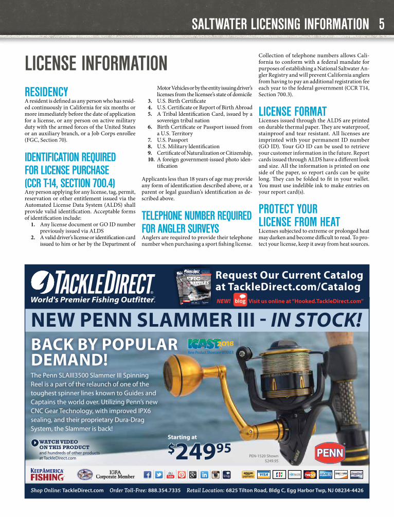
New PeNN Slammer III - IN STock!New Product Showcase WiNNer
BaCK BY POPUlar DemaND!The Penn SLAIII3500 Slammer III Spinning Reel is a part of the relaunch of one of the toughest spinner lines known to Guides and Captains the world over. Utilizing Penn’s new CNC Gear Technology, with improved IPX6 sealing, and their proprietary Dura-Drag System, the Slammer is back!
and hundreds of other products at TackleDirect.com
WATCH VIDEO ON THIS PRODUCT
PEN-1520 Shown$249.95
$24995Starting at
request Our Current Catalog at TackleDirect.com/Catalog
2017 Product Guide Volume VI, Issue 1
Photo: Captain Fernando Almada
facebook.com/Catch22fi shing
INSIDE!
CHECK IT OUT!
Light at 14.4 ounces, handles 325
yards of 50lb. braid, and cranks
38 inches of line turn!...PG 18
MAUREEN KLAUSE
TackleDirect Pro-Sta� er & IGFA
Multi World Record Holding Angler
GET PACKING!
The best bags & gear for
your travels! PG 26-27
EPICBATTLESDON’T BE CAUGHT OFF GUARD THIS YEAR!
2017 Product Guide Volume VI, Issue 1
Photo: Captain Fernando Almada
facebook.com/Catch22fi shing
INSIDE!
Light at 14.4 ounces, handles 325
yards of 50lb. braid, and cranks
38 inches of line turn!...PG 18
MAUREEN KLAUSE
TackleDirect Pro-Sta� er & IGFA
Multi World Record Holding Angler
GET PACKING!
The best bags & gear for
your travels! PG 26-27
EPICBATTLESDON’T BE CAUGHT OFF GUARD THIS YEAR!
DON’T BE CAUGHT OFF GUARD THIS YEAR!
DON’T BE CAUGHT OFF GUARD THIS YEAR!
DON’T BE CAUGHT OFF GUARD THIS YEAR!
0000_TD_Winter CATALOG.indd 1
11/8/2016 10:47:41 AM
2017 Product Guide Volume VI, Issue 1
Photo: Captain Fernando Almadafacebook.com/Catch22fi shing
INSIDE!
CHECK IT OUT!Light at 14.4 ounces, handles 325
yards of 50lb. braid, and cranks 38 inches of line turn!...PG 18
MAUREEN KLAUSETackleDirect Pro-Sta� er & IGFA Multi World Record Holding Angler
GET PACKING!The best bags & gear for your travels! PG 26-27
EPICBATTLESDON’T BE CAUGHT OFF GUARD THIS YEAR!
2017 Product Guide Volume VI, Issue 1
Photo: Captain Fernando Almadafacebook.com/Catch22fi shing
INSIDE!
Light at 14.4 ounces, handles 325 yards of 50lb. braid, and cranks
38 inches of line turn!...PG 18
MAUREEN KLAUSETackleDirect Pro-Sta� er & IGFA Multi World Record Holding Angler
GET PACKING!The best bags & gear for your travels! PG 26-27
EPICBATTLESDON’T BE CAUGHT OFF GUARD THIS YEAR! DON’T BE CAUGHT OFF GUARD THIS YEAR! DON’T BE CAUGHT OFF GUARD THIS YEAR! DON’T BE CAUGHT OFF GUARD THIS YEAR!
0000_TD_Winter CATALOG.indd 1 11/8/2016 10:47:41 AM
Shop Online: TackleDirect.com Order Toll-Free: 888.354.7335 Retail Location: 6825 Tilton Road, Bldg C, Egg Harbor Twp, NJ 08234-4426
NEW! Visit us online at “Hooked.TackleDirect.com”
5

SALTWATER LICENSING INFORMATION
PURCHASING A LICENSE FOR ANOTHER PERSONRegulations provide that a person may purchase a hunting or sport fishing license, tags, or valida-tions for another person, as long as the licensee’s customer identification number issued from the ALDS and date of birth are provided. If a person wishes to purchase a sport fishing license for another person but does not have the required information, a gift voucher may be purchased for that person that may be redeemed for a resident sport fishing license. Gift vouchers are non-re-fundable and valid only for the year specified (CCR T-14, Section 700.3).
LICENSE PROVISIONSAny person who is 16 years of age or older must have a sport fishing license to take any kind of fish, mollusk, invertebrate, amphibian or crustacean in California, except when taken from a public pier in ocean or bay waters. A sport fishing license is required to take reptiles, except for rattlesnakes.
REPORT CARD REQUIREMENTSAnglers who are not required to have a sport fishing license, such as anglers who are under 16 years of age and anglers who will be fishing on Free Fishing Days, are required to have report cards to fish for: abalone, spiny lobster, and sturgeon.
Important Reminder: Return of Report Cards is Mandatory. Report cards must be reported on-line at wildlife.ca.gov/reportcards or returned to the CDFW at the address specified on the report card by January 31 of the following year (except Spiny Lobster Report Cards, which must be report-ed by April 30, following the close of lobster season).
Any person who fails to report online or return his or her report card to the CDFW by the deadline may be restricted from obtaining the same card in a subsequent license year or may be subject to an additional fee for the issuance of the same card in a subsequent license year (CCR T-14, Section 1.74).
A $21.60 non-return fee will be charged when purchasing a spiny lobster report card if the previ-ous year’s report card is not returned or reported by the April 30 deadline. To avoid the fee, you may either return or report your card by the deadline, or skip one lobster fishing season. After skipping one season, you can purchase a spiny lobster re-port card the following season at no extra cost.
POSSESSION OF LICENSEEvery person, while engaged in taking any fish, amphibian or reptile, shall have a valid sport fish-ing license on their person in their immediate possession except when diving as provided in FGC Section 7145 and CCR T-14, Section 700.
Persons diving from a boat or shore may have their license on the boat or within 500 yards of shore, respectively (FGC, Section 7145).
DUPLICATE SPORT FISHING LICENSESIf you lose your sport fishing license and valida-tions, visit any license agent or CDFW license sales office, or log in to the license sales service at wildlife.ca.gov/licensing/online-sales to obtain a low-cost duplicate and validations. Duplicate Abalone Report Cards and Sturgeon Report Cards may only be purchased at CDFW license sales offices.
REFUND POLICYRefunds will not be issued for sport fishing licens-es, vouchers, validations or report cards. These items are considered in use from the date issued, and therefore are non-refundable.
REMINDERS FOR CPFV OWNERS, CPFV OPERATORS, AND ANGLERS ON CPFVs
The cooperation of owners and operators of commercial passenger fishing vessels (CPFVs) has been critical to the success of the California Recreational Fisheries Survey (CRFS) since its inception in 2004. The data collected by CRFS is used to estimate the catch (total number of fish by species) and effort (total number of fishing trips) of saltwater recreational anglers, and to assist in the establishment of regulations aimed to maximize fishing oppor-tunities while conserving fisheries for future use.
CRFS samplers interview anglers and crew, and examine catch onboard CPFVs both at sea and dockside. CPFV owners and operators are reminded that accurate catch and effort estimates depend on access to both kept and discarded catch information by CRFS samplers. In addition, CRFS samplers must observe both open party and chartered trips, and must gather effort data frequently to ensure the best possible estimates.
By law (California Code of Regulations T-14, Section 105.5), owners or operators of CPFVs must carry and accommodate CRFS samplers on fishing trips when asked. If sampler cov-erage of a trip is denied by the owner or operator of the vessel, the CDFW may request a written explanation for the denial, and CPFV owners or operators who deny sampler coverage of a trip may have their fishing permits or licenses revoked.
Anglers are encouraged to answer CRFS samplers’ questions; however, angler partici-pation in the survey is voluntary. CRFS samplers will ask anglers aboard CPFVs about the species they kept and discarded, how often they fish, and their zip code. CRFS samplers will also ask the crew about fishing target(s), descending device usage, and bottom depth. Onboard the vessel, while anglers are fishing, CRFS samplers will collect data on catch rates, species composition, fishing locations, and length of fish that the anglers do not keep. After anglers have completed fishing for the day, CRFS samplers will record the lengths and weights of fish that were kept.
Further information about CRFS, and a link to recreational catch and effort estimates, is available on the CDFW website at www.wildlife.ca.gov/conservation/marine/CRFS.
CD
FW p
hoto
by
R D
ento
nP
hoto
by
S. O
’Brie
n
6
2017–2018 CALIFORNIA SALTWATER FISHING REGULATIONS
FORTHCOMING SUPPLEMENT
A supplement updating the regulations contained in this booklet will be released by May 2017. The supplement is produced to update the ocean and inland salmon regulations and any other regulations that have changed since the publication of the 2017-2018 Saltwater Sport Fishing regulation booklet. The supplement will not include the complete set of regulations contained in the Saltwater Sport Fishing regulation booklet, so please retain this booklet.
SALTWATER LICENSING INFORMATION
FREE AND REDUCED-FEE SPORT FISHING LICENSESCDFW offers reduced-fee sport fishing licenses to honorably-discharged veterans with a service-con-nected disability rating of at least 50 percent, to recovering service members, and to resident low-in-come seniors who are at least 65 years of age. The term ‘‘recovering service member’’ means a mem-ber of the Armed Forces, including a member of the National Guard or a Reserve, who is undergoing medical treatment, recuperation, or therapy and is in an outpatient status while recovering from a serious injury or illness related to the member’s mil-itary service (FGC, Section 7150). Disabled veterans and recovering service members can pre-qualify for reduced-fee sport fishing licenses via e-mail. To pre-qualify, email your CDFW-issued GO ID and a letter from the Veteran’s Administration docu-menting your service-connected disability rating of 50 percent or greater to [email protected]. After your customer record has been updated, you will be able to purchase a reduced-fee fishing license anywhere licenses are sold.
Free sport fishing licenses are available to eligi-ble persons who are blind, low-income American Indians, developmentally disabled persons, and residents who are so severely physically disabled that they are permanently unable to move from place to place without the use of a wheelchair, walker, forearm crutches, or a comparable mo-bility-related device.
Eligibility for free and reduced-fee sport fishing licenses will be verified. Applications and addi-tional information are available online at wildlife.ca.gov/licensing/fishing.
LICENSE SALES BY TELEPHONESport fishing licenses, validations, and report cards may be purchased via telephone from Active Network’s telephone license sales line at (800) 565-1458. Items purchased by telephone sales will be delivered by mail within 15 days of purchase.
PURCHASE LICENSES AND SUBMIT HARVEST INFO ONLINE
You can now purchase California sport fishing licenses and validations and submit report card information online. For more information, visit CDFW’s license sales website at wildlife.ca.gov/licensing/online-sales
STAY CONNECTED
Giving CDFW your e-mail address and mobile number will enable us to send you informa-tion you can use, such as license renewal and courtesy report card deadline reminders, and California fishing information. When purchasing a license from a license agent or when you log in to the Online License Service, update your communication preferences and provide your e-mail address and mobile number. Fish and Game Code Section 1050.6 and California Government Code Section 11015.5 prohibit CDFW from selling or sharing your personal information with any third party.
YOUR WARDEN STAMP DOLLARS AT WORK
Your $5 Warden Stamp purchase helps protect California’s fish and wildlife resources.
The California Department of Fish and Wildlife’s Warden Stamp Pro-gram provides equipment and training for wildlife officers and funds CDFW’s popular K-9 Program, which trains dogs to work side by side with wildlife officers in preventing and solving wildlife crimes.
wildlife.ca.gov/warden-stamp
REGULATIONS ON THE GO
Did you know you can now download state ocean fishing regulations to your smartphone or other devices?
By utilizing iBooks on Apple devices or your favorite book reader on the Android platform you can download the regulations booklet for reference at any time. Regulation booklets can be found online at wildlife.ca.gov/regulations.
7
2017–2018 CALIFORNIA SALTWATER FISHING REGULATIONS

SALTWATER SPORT FISHING LICENSE FEES
LICENSE FEESSALTWATER FISHING LICENSE FEESANNUAL LICENSES
Resident Sport Fishing License $47.01
Non-Resident Sport Fishing License $126.62
Reduced-Fee Sport Fishing License $6.95
SHORT-TERM LICENSES
One-Day Sport Fishing License (resident or nonresident) $15.12
Two-Day Sport Fishing License* (resident or nonresident) $23.50
Ten-Day Non-Resident Sport Fishing License** $47.01
REPORT CARDS AND VALIDATIONS
Sport Ocean Enhancement Validation $5.14
Abalone Report Card $22.42
Spiny Lobster Report Card $9.46
Spiny Lobster Report Card Non-Reporting Fee $21.60
Sturgeon Fishing Report Card $8.13
OTHER PERMITS
Declaration for Multi-day Fishing Trip $5.92
DUPLICATE FEES
Sport Fishing License (Annual) $10.54
Ocean Enhancement Validation $3.24
Abalone Report Card (available at CDFW license sales offices only) $18.03
Sturgeon Fishing Replacement Card (available at CDFW license sales offices only) $15.45
LIFETIME SPORT FISHING LICENSES
Age 9 years or younger $518.25
Age 10 to 39 years $846.75
Age 40 to 61 years $763.00
Age 62 years or older $518.25
Additional Lifetime Fishing Privileges (includes: Ocean Enhancement Validation and three items that apply only to inland freshwater fishing: Second Rod Validation, North Coast Salmon Report Card, and Steelhead Report Card)
$350.75
Lifetime licenses are available only at CDFW license sales offices.Most fees include 5% license agent handling fee and 3% nonrefundable application fee.* Valid for two consecutive calendar days.** Valid for ten consecutive calendar days.
“one cut andyou’re Through™”
High carbon steel withfull tang construction
Razor sharp serrated blade with non-stick coating
Big red no-slip-griphandle with safetyguards and trigger grip
7-InchTaperedFLEX Fillet
SEE THE FULL LINE OF FISHING AND HUNTINGKNIVES AT WWW.BUBBABLADE.COM
OR ORDER BY PHONE AT 1-844-486-7265
Razor sharp serrated blade
FLEX Fillet
We Provide Hunting Opportunities to
Law Enforcement AgentsInjured in the Line of Duty.
To Volunteer Or Donate, Please Visit Our Website
HuntingForHeroes.org
8
2017–2018 CALIFORNIA SALTWATER FISHING REGULATIONS

MANAGING CALIFORNIA’S FISHERIES
DO YOUR PART TO HELP MANAGE CALIFORNIA’S MARINE RECREATIONAL FISHERIES!
Metal Fish 66Artegon Marketplace
5250 International DriveSuite D-10
Orlando, FL 32819www.metalfi sh66.com
321-277-8650
Handcrafted sea life-inspired stainless steel art sculptures
with spectacular colors!
Sculptures available in 18”, 25”, 36” and 45” sizes!
Check out our 7” vinyl stickers of the sculptures. Perfect for your vehicle or boat!
You’ve just returned to the dock after a fun (and hopefully rewarding) day of ocean sport fishing. As you tie up the boat and get ready to disembark, a smiling person in a CDFW uniform strolls down the dock, clipboard and measuring board in hand, and asks about your trip. How was the fishing today?
More than likely, you’ve just met a fishery sam-pler from the California Recreational Fisheries Survey (CRFS), a survey of saltwater sport anglers. The data that you provide to CRFS helps fishery managers set size limits, bag limits and fishing seasons with the goal of maximizing your fishing opportunity while conserving the fish species you caught today for generations to come.
Fishery managers use CRFS data to estimate the total catch (total number of fish caught) and fishing effort (number of fishing trips) of marine recreational anglers in California. CRFS was de-signed to meet specific management needs for all of California’s diverse recreational marine fish-eries, and provide accurate and timely estimates. The accuracy of the estimates generated by CRFS depends heavily on your cooperation!
THERE ARE TWO WAYS THAT YOU CAN CONTRIBUTE TO THE ACCURACY OF THE DATA:1. Cooperate with the CRFS field samplers conducting the interview:Because every fishing trip is unique – different target species, fishing locations, and catch – we ask that saltwater anglers cooperate each and every time they are approached by a CRFS sam-pler. Answer the CRFS sampler’s questions about your fishing trip truthfully and to the best of your knowledge, and take the time to allow the sampler to examine, measure and weigh your catch.
2. Say “Yes” when you are contacted by a CRFS telephone surveyor:Licensed anglers are contacted randomly through-out the year and asked questions about their fishing experiences. Data collected through this telephone survey are used to estimate fishing effort that cannot be estimated through field
observations, such as night fishing and fishing from boats that depart from and return to private marinas. Your personal contact information is kept confidential.
Please do your part and say “Yes” when asked to participate in this important survey. Thank you!
For more information about the CRFS, including recreational catch and effort estimates, visit the CDFW website at wildlife.ca.gov/conservation/marine/CRFS.
CD
FW p
hoto
CRFS sampler Jared Worland examines a
California halibut.
9

HARVEST REPORTING
HARVEST REPORTING: EASIER THAN EVER
• Report your harvest online, using the Online License Service at wildlife.ca.gov/Licensing/Online-Sales; or
• Return your report card via mail to the address printed on the card. If you mail your card, con-sider using certified mail with tracking and re-tain the tracking number for proof of submittal in case your card is lost in the mail. Cards that are lost in the mail are considered not returned.
• Accurate and complete data is required. If you report online, all entries on the report card must be entered in the electronic form, includ-ing sport fishing reports of activity when no catches were made.
• Submission of report card data online must be completed within 20 minutes to avoid a system time out.
ONLINE HARVEST REPORTING IS AVAILABLE ON THESE DATES:HARVEST REPORT TYPE REPORTING DATES LATE REPORTING*Abalone Report Card Dec 1 - Jan 31 Feb 1 - Apr 1
Spiny Lobster Report Card The day after the last day of the season - Apr 30 May 1 - Jul 1
Sturgeon Fishing Report Card Jan 1 - Jan 31 Feb 1 - Apr 1
*Late reporting occurs after the regulatory deadline.If you have not reported your harvest by the dates listed above, please mail your harvest report card to the address listed on the report card immediately.
• Sport fishing report cards may be reported online only after the last day of the report card’s validity.
• If you report online, do not mail in your report card. You will be issued a report confirmation number. After reporting, please write your re-port confirmation number on your report card, and retain it as proof of submittal. Once a report card has been reported, it may no longer be used in the field.
Remember, a $21.60 non-return fee will be charged when purchasing a spiny lobster report card if the previous year’s report card is not returned or report-ed online by the April 30 deadline! To avoid the fee, you may either return or report your card by the deadline, or skip one lobster fishing season. After skipping one season, you can purchase a spiny lobster report card the following season at no extra cost.
HEALTHY SEABIRDS, HEALTHY OCEANS
Special Closures protect seabirds and marine mammals from close-approaching watercraft.
Know Before You Go! Special Closures are closed to all watercraft.
Please review the table beginning on pg. 44 for Special Closures in your area.
Follow these tips to minimize your impact:• Stay at least 1,000 feet from cliffs,
rocks and islands• Dispose of fishing line, hooks,
lures and extra bait properly. Do not throw anything overboard
• Steer around, not through floating flocks of seabirds
• If birds begin to flutter wings, move away, you are too close
• Avoid shining bright lights at cliffs and islands where seabirds nest
Why? The productive marine environ-ment off the California coast is a feeding, breeding and resting area for hundreds of thousands of seabirds. Seabirds nest on offshore rocks, islands and steep mainland cliffs in order to avoid preda-tors. Many seabird species lay only one egg a year, or even every other year. This low reproductive rate makes sea-birds extremely vulnerable. Getting too close to seabirds in a boat or on foot may disrupt breeding and feeding or harm seabirds and their chicks.
Find out more information at www.SeabirdProtectionNetwork.org
Notice courtesy of the National Oceanic and Atmospheric Administration
USEFUL CDFW SITE LINKS
California Ocean Sport Fishing Regulations Map:wildlife.ca.gov/fishing/ocean/regulations/fishing-map
California Fishing Passport Program:wildlife.ca.gov/fishing/passport
CDFW Law Enforcement:wildlife.ca.gov/enforcement
Finfish and Shellfish Identification:wildlife.ca.gov/fishing/ocean/fish-id
Groundfish Management:wildlife.ca.gov/conservation/marine/groundfish
Ocean Salmon Information:wildlife.ca.gov/fishing/oceansalmon
Marine BIOS (coastal and marine data viewer):wildlife.ca.gov/marinebios
Marine Protected Areas:wildlife.ca.gov/mpas
Declaration for Entry Form:wildlife.ca.gov/enforcement/entry-declaration
Marine Management News Blog:cdfwmarine.wordpress.com
Marine Region Electronic News Service:wildlife.ca.gov/regions/marine/news/subscribe
Ocean Sport Fishing Information:wildlife.ca.gov/ocean-sport-regs
10
2017–2018 CALIFORNIA SALTWATER FISHING REGULATIONS

Recreational groundfish fishing regulations are adaptive and based on the latest information about the fishery. Therefore, the CDFW director can change state groundfish regulations during the year to conform to changes in federal regulations. Before engaging in ocean sportfishing for ground-fish and associated species, please access one of the following sources for up-to-date information concerning season dates, allowed fishing depths, and other regulations:• Call the Recreational Groundfish Fishing Reg-
ulations Hotline at (831) 649-2801 for the latest groundfish regulations.
• Check the CDFW News Room at wildlife.ca.gov/news or the Marine Region News Page at wildlife.ca.gov/regions/marine/news.
• Go to wildlife.ca.gov/regions/marine/news/subscribe and sign up for e-mail notification of in-season regulation changes.
• Call or drop by your local Marine Region CDFW office (see pg. 2) for the latest infor-mation before heading out on a fishing trip.
CCR T-14, SECTION 27.20(e)Describes the process CDFW follows to enact in-season regulation adjustments for groundfish:
“Fishery closure and/or rule change: When the department determines, based on the best avail-able scientific information, that an annual harvest limit [optimum yield (OY), annual catch limit (ACL), annual catch target (ACT), recreational harvest guideline, or recreational harvest target] established in regulation by the NOAA Fisheries (National Marine Fisheries Service) for any species of federally-managed groundfish or aggregate group of federal groundfish species has been ex-ceeded or is projected to be exceeded prior to the end of the year or that catches are less than predicted, the following rule changes may occur:
(1) The department may modify the seasons and/or depth constraints for any species of federally-managed groundfish or aggregate group of federal groundfish species, Cali-fornia sheephead, ocean whitefish, and all greenlings of the genus Hexagrammos. Sea-son and/or depth modifications may differ by Groundfish Management Area, time of year, mode of fishing, or gear utilized.
(2) The department may adjust existing bag or sub-bag limits or establish additional bag or sub-bag limits as needed for any species of federally-managed groundfish or aggregate group of federal groundfish species, Cali-
fornia sheephead, ocean whitefish, and all greenlings of the genus Hexagrammos. Bag limits may differ by Groundfish Manage-ment Area, time of year, mode of fishing, or gear utilized.
(3) The department may adjust existing size limits or establish additional size limits as needed for any species of federally-managed groundfish or aggregate group of federal groundfish species, California sheephead, ocean whitefish, and all greenlings of the genus Hexagrammos. Size limits may differ by Groundfish Management Area, time of year, mode of fishing, or gear utilized.
CCR T-14, SECTION 27.20(f)Describes how CDFW notifies the federal gov-ernment and the public of in-season changes to groundfish fishing regulations:
“Notice of closure and/or rule change: The de-partment shall give the public and the NOAA Fisheries no less than 10 calendar days’ notice of any fishery closure or rule change implemented pursuant to this Section via a department news release. Anglers and divers are advised to check the current rules before fishing. The latest fishing rules may be found on the department’s website at: www.wildlife.ca.gov/regions/marine, or by calling (831) 649-2801 for recorded information, or by contacting a department office.”
Note: “Federal Groundfish” is defined in CCR T-14, Section 1.91 (pg. 22).
KEEPING UP WITH IN-SEASON GROUNDFISH REGULATION CHANGES
GROUNDFISH INFORMATION
BLACK ROCKFISH VS. BLUE ROCKFISH
Black rockfish and blue rockfish are often misidentified. Use the features below to differentiate between the two species.
For more fish identification information, please visit the CDFW website at wildlife.ca.gov/fishing/ocean/fish-IDFor regulations, call the Recreational Groundfish Fishing Regulations Hotline at (831) 649-2801 C
DFW
pho
tos
by E
.W. R
ober
ts II
I
Black Rockfish Blue Rockfish
2 to 4 dark bandsaround front of head
Maxillary extends to near mid-eye
Straight-edged and slanted
anal finRounded
anal fin
Body Color: mottled and blotched with BLACK to
BLUE-BLACK and GRAY
Body Color: mottled BLUE-BLACK to
BRIGHT BLUE
No black spots on dorsal fin membrane
Small knob at tip of lower jaw
Black spots on dorsal fin membrane
Maxillary extends to back of eye
11
2017–2018 CALIFORNIA SALTWATER FISHING REGULATIONS

GROUNDFISH MANAGEMENT AREAS FOR 2017Note: Groundfish regulations may change during the year. Before engaging in ocean sportfishing for groundfish and associated species, please access one of the sources listed on page 11 to obtain the most up-to-date groundfish fishing regulations.
Five recreational groundfish management areas have been established by the Fish and Game Commission and the Pacific Fishery Management Council. Each area has a different set of groundfish regulations tailored to meet regional needs.
GROUNDFISH MANAGEMENT AREAS
INTERSTATE WILDLIFE VIOLATOR COMPACT
The Interstate Wildlife Violator Com-pact (IWVC) is an agreement between 26 states, which allows for the recip-rocal recognition of hunting, fishing and trapping license suspensions. If your license privileges have been suspended by another state, the sus-pension may be recognized here in California. For example, if your sport fishing, hunting or trapping privileges have been suspended in Colorado for five years, your privileges may also be suspended for five years in California or any of the states participating in the IWVC.
The purchase of licenses or tags during the term of the suspension is a violation of the law and may result in prosecution. Licenses or tags pur-chased prior to or during a suspension are not refundable.
For further information contact the CDFW Law Enforcement Division at 1416 Ninth Street, Sacramento, CA 95814, or (916) 653-4094.
SAVE OUR WATER
Now more than ever, it’s important to conserve our most precious resource. Find out how you can help.
Learn to conserve water.www.SaveOurWater.com
RECREATIONAL GROUNDFISH MANAGEMENT AREAS FOR 2017
12
2017–2018 CALIFORNIA SALTWATER FISHING REGULATIONS

GROUNDFISH REGULATION SUMMARY TABLES
SPECIES TIME PERIOD 1, 2, 3 DEPTH LIMIT 1, 2, 3 DAILY BAG LIMIT 1 MIN. SIZE LIMIT 1, 4, 5
RCG Complex1 (includes all species of Rockfishes, Cabezon and Greenlings, Sections 1.91 and 28.55, 28.28, and 28.29)
Boat-based Anglers2: Open: May 1–Oct 31, and Nov 1–Dec 31 Closed: Jan 1–Apr 30
Divers, Shore-based Anglers2: Open year-round
May 1- Oct 31: Take is prohib-ited seaward of the 30 fathom depth contour (180 feet), defined in Federal regulations (50 CFR Part 660, Subpart C)
Nov 1-Dec 31: May be taken at any depth
SEE EXCEPTION AT END OF TABLE
10 fish in combination per person EXCEPT: Cabezon: 3 fish per person Canary rockfish: 1 fish per person Black rockfish: 3 fish per person
See individual species and groups below
Cabezon: 15” total length
Kelp and/or rock greenlings: 12” total length
Lingcod (Section 28.27) Same as RCG Complex, above 2 fish per person 22” total length
Leopard Shark6 (Section 28.56)
All Anglers: Same as RCG Complex outside of Humboldt Bay
Open year-round within Humboldt Bay
Divers, Shore-based Anglers2: Open year-round
All Anglers: Same as RCG Complex out-side of Humboldt Bay
No depth limit within Humboldt Bay
Divers, Shore-based Anglers2: Same as RCG Complex
3 fish per person 36” total length
Pacific Sanddabs and “Other Flatfish”3 (Section 28.48)
Open year-round No depth limit
Pacific sanddab: No limit
All “Other Flatfish”3: 10 fish of each species, limit 20 fish total in combination per Section 27.60
No size limit
Petrale Sole and Starry Flounder (Section 28.47)
Open year-round No depth limit No limit No size limit
Other Federal Groundfish (Section 28.49) Same as RCG Complex, above
Soupfin shark: 1 fish per person
All Other Federal Groundfish: 10 fish of each species, limit 20 fish total in combination per Section 27.60
No size limit
These rockfishes may not be taken in California: Cowcod, Bronzespotted Rockfish, and Yelloweye Rockfish (Section 28.55) Fishing is closed year-round, at all depths. No retention at any time (zero fish per person)
1. Subject to in-season change. Call the Recreational Groundfish Fishing Regulations Hotline at (831) 649-2801, visit the Marine Region Web site at www.wildlife.ca.gov/Fishing/Ocean/Regulations/Inseason, send an e-mail to [email protected], or call your nearest CDFW office for the latest information. Some marine protected areas (MPAs) restrict or prohibit sport fishing within MPAs. Check the current ocean sport fishing regulations booklet or the CDFW website at www.wildlife.ca.gov/MPAs/Northern-California, send an e-mail to [email protected], or call your nearest CDFW office for more information.
2. Divers and shore-based anglers are exempt from season restrictions affect-ing the RCG complex and other federally managed groundfish. However, when spear fishing during a boat-based closure, only spear fishing gear is allowed aboard any vessel or watercraft. Also, when angling from shore during a boat-based closure, no vessel or watercraft may be used to assist in taking or possessing species included in this table. The following definitions describe boat-based and shore-based anglers, and divers: • Boat-based anglers are fishermen that fish from boats or vessels of any
size or any other type of floating object, including kayaks and float tubes. • Shore-based anglers are fishermen that fish from beaches, banks, piers,
jetties, breakwaters, docks and other manmade structures connected to the shore.
• Divers are spear fishermen entering the water either from the shore or from a boat or other floating object.
3. During the closed season, Pacific sanddab, butter sole, curlfin sole, flathead sole, rex sole, rock sole, and sand sole (defined as “Other Flatfish” in sub-section 1.91(a)(10)) may be taken.
4. See regulations for information on gear restrictions (Sections 28.65, 28.70, 28.90, 28.91, and 28.95) and fillet lengths (Section 27.65).
5. Total length is the longest straight-line measurement from the tip of the head with the mouth closed to the end of the longest lobe of the tail. A measure-ment method illustration is available on pg. 23.
6. The sport fishery for leopard shark inside Humboldt Bay is exempt from season and depth restrictions that affect other federally managed groundfish (Section 28.56).
EXCEPTION: During the open season, groundfish may be possessed in closed areas and in water depths closed to fishing only aboard vessels in transit with no fishing gear in the water (Section 27.20(b)).
NORTHERN MANAGEMENT AREA
Ocean waters between 42°00’ N. latitude (CA-OR Border) and 40°10’ N. latitude (near Cape Mendocino). Includes all of Del Norte County and most of Humboldt County
Note: Red text indicates regulations that were updated for 2017. Before engaging in ocean sportfishing for groundfish and associated species, please review one of the resources listed in Footnote 1 to receive the most up-to-date regulations.
13

GROUNDFISH REGULATION SUMMARY TABLES
SPECIES TIME PERIOD 1, 2, 3 DEPTH LIMIT 1, 2, 3 DAILY BAG LIMIT 1 MIN. SIZE LIMIT 1, 4, 5
RCG Complex1 (includes all species of Rockfishes, Cabezon and Greenlings, Sections 1.91 and 28.55, 28.28, and 28.29)
Boat-based Anglers2: Open: May 1-Oct 31, and Nov 1-Dec 31 Closed: Jan 1–Apr 30
Divers, Shore-based Anglers2: Open year-round
May 1-Oct 31: Take is prohib-ited seaward of 20 fathoms (120 feet) in depth
Nov 1-Dec 31: May be taken at any depth
SEE EXCEPTION AT END OF TABLE
10 fish in combination per person EXCEPT: Cabezon: 3 fish per person Canary rockfish: 1 fish per person Black rockfish: 3 fish per person
See individual species and groups below
Cabezon: 15” total length
Kelp and/or rock greenlings: 12” total length
Lingcod (Section 28.27) Same as RCG Complex, above 2 fish per person 22” total length
Leopard Shark (Section 28.56)
Boat-based Anglers2: Same as RCG Complex, above
Divers, Shore-based Anglers2: Open year-round
All Anglers: Same as RCG Complex, above 3 fish per person 36” total length
California Scorpionfish (Section 28.54)
Boat-based Anglers2: Open: May 1-Aug 31 Closed: Jan 1-Apr 30 and Sep 1-Dec 31
Divers, Shore-based Anglers2: Open year-round
Same as RCG Complex, above 5 fish per person 10” total length
Pacific Sanddabs and “Other Flatfish”3 (Section 28.48)
Open year-round No depth limit
Pacific sanddab: No limit
All “Other Flatfish”3: 10 fish of each species, limit 20 fish total in combination, per Section 27.60
No size limit
Petrale Sole and Starry Flounder (Section 28.47)
Open year-round No depth limit No limit No size limit
Other Federal Groundfish (Section 28.49) Same as RCG Complex, above
Soupfin shark: 1 fish per person
All Other Federal Groundfish: 10 fish of each species, limit 20 fish total in combination, per Section 27.60
No size limit
These rockfishes may not be taken in California: Cowcod, Bronzespotted Rockfish, and Yelloweye Rockfish (Section 28.55) Fishing is closed year-round, at all depths. No retention at any time (zero fish per person)
1. Subject to in-season change. Call the Recreational Groundfish Fishing Regulations Hotline at (831) 649-2801, visit the Marine Region Web site at www.wildlife.ca.gov/Fishing/Ocean/Regulations/Inseason, send an e-mail to [email protected], or call your nearest CDFW office for the latest information. Some marine protected areas (MPAs) restrict or prohibit sport fishing within MPAs. Check the current ocean sport fishing regulations booklet or the CDFW website at www.wildlife.ca.gov/MPAs/Northern-Cal-ifornia, send an e-mail to [email protected], or call your nearest CDFW office for more information.
2. Divers and shore-based anglers are exempt from season restrictions affecting the RCG complex and other federally managed groundfish. However, when spear fishing during a boat-based closure, only spear fishing gear is allowed aboard any vessel or watercraft. Also, when angling from shore during a boat-based closure, no vessel or watercraft may be used to assist in taking or possessing species included in this table. The following definitions describe boat-based and shore-based anglers, and divers: • Boat-based anglers are fishermen that fish from boats or vessels of any size
or any other type of floating object, including kayaks and float tubes. • Shore-based anglers are fishermen that fish from beaches, banks, piers,
jetties, breakwaters, docks and other manmade structures connected to the shore.
• Divers are spear fishermen entering the water either from the shore or from a boat or other floating object.
3. During the closed season, Pacific sanddab, butter sole, curlfin sole, flathead sole, rex sole, rock sole, and sand sole (defined as “Other Flatfish” in subsec-tion 1.91(a)(10)) may be taken.
4. See regulations for information on gear restrictions (Sections 28.65, 28.70, 28.90, 28.91, and 28.95) and fillet lengths (Section 27.65).
5. Total length is the longest straight-line measurement from the tip of the head with the mouth closed to the end of the longest lobe of the tail. A measurement method illustration is available on pg. 23.
EXCEPTION: During the open season, groundfish may be possessed in closed areas and in water depths closed to fishing only aboard vessels in transit with no fishing gear in the water (Section 27.20(b)).
MENDOCINO MANAGEMENT AREA
Ocean waters between 40°10’ N. latitude (near Cape Mendocino) and 38°57.5’ N. latitude (Point Arena). Includes a portion of Humboldt County and most of Mendocino County
Note: Red text indicates regulations that have changed for 2017. Before engaging in ocean sportfishing for groundfish and associated species, please review one of the resources listed in Footnote 1 to receive the most up-to-date regulations.
14

SPECIES TIME PERIOD 1, 2, 3, 4 DEPTH LIMIT 1, 2, 3, 4 DAILY BAG LIMIT 1 MIN. SIZE LIMIT 1, 5, 6
RCG Complex1 (includes all species of Rockfishes, Cabezon and Greenlings, Sections 1.91 and 28.55, 28.28, and 28.29)
Boat-based Anglers2: Open: Apr 15–Dec 31 Closed: Jan 1–Apr 14
Divers, Shore-based Anglers2,4: Open year-round
Take is prohibited seaward of the 40 fathom depth contour (240 feet), defined in Federal regulations (50 CFR Part 660, Subpart C)
SEE EXCEPTION AT END OF TABLE
10 fish in combination per person EXCEPT: Cabezon: 3 fish per person Canary rockfish: 1 fish per person Black rockfish: 3 fish per person
See individual species and groups below
Cabezon: 15” total length
Kelp and/or rock greenlings: 12” total length
Lingcod (Section 28.27) Same as RCG Complex, above 2 fish per person 22” total length
California Scorpionfish (Section 28.54)
Boat-based Anglers2: Open: April 15-Aug 31 Closed: Jan 1-Apr 14, and Sep 1- Dec 31
Divers, Shore-based Anglers2: Open year-round
Same as RCG Complex, above 5 fish per person 10” total length
Leopard Shark7 (Section 28.56)
All Anglers Open year-round within San Francisco Bay, Bodega Harbor, Tomales Bay, Bolinas Bay and Drake’s Bay
Same as RCG Complex outside of those bays
Divers, Shore-based Anglers2: Open year-round
All Anglers No depth limit within San Francisco Bay, Bodega Harbor, Tomales Bay, Bolinas Bay and Drake’s Bay
Same as RCG Complex outside of those bays
Divers, Shore-based Anglers2: Same as RCG Complex, above
3 fish per person 36” total length
Pacific Sanddabs and “Other Flatfish”3 (Section 28.48)
Open year-round No depth limit4
Pacific sanddab: No limit
All “Other Flatfish”3: 10 fish of each species, limit 20 fish total in combination, per Section 27.60
No size limit
Petrale Sole and Starry Flounder (Section 28.47)
Open year-round No depth limit No limit No size limit
Other Federal Groundfish (Section 28.49) Same as RCG Complex, above
Soupfin shark: 1 fish per person
All Other Federal Groundfish: 10 fish of each species, limit 20 fish total in combination, per Section 27.60
No size limit
These rockfishes may not be taken in California: Cowcod, Bronzespotted Rockfish, and Yelloweye Rockfish (Section 28.55) Fishing is closed year-round, at all depths. No retention at any time (zero fish per person)
1. Subject to in-season change. Call the Recreational Groundfish Fishing hotline at (831) 649-2801, visit the Marine Region Web site at www.wildlife.ca.gov/Fishing/Ocean/Regulations/Inseason, send an e-mail to [email protected], or call your nearest CDFW office for the latest information. Some marine protected areas (MPAs) restrict or prohibit sport fishing within MPAs. Check the current ocean sport fishing regulations booklet or the CDFW website at www.wildlife.ca.gov/MPAs/North-Central-California for the open ocean coast, or www.wildlife.ca.gov/Conservation/MPAs/San-Francisco-Bay for San Francisco Bay. You may also send an e-mail to [email protected], or call your nearest CDFW office.
2. Divers and shore-based anglers are exempt from season restrictions affecting the RCG complex and other federally managed groundfish. However, when spear fishing during a boat-based closure, only spear fishing gear is allowed aboard any vessel or watercraft. Also, when angling from shore during a boat-based closure, no vessel or watercraft may be used to assist in taking or possessing species included in this table. The following definitions describe boat-based and shore-based anglers, and divers: • Boat-based anglers are fishermen that fish from boats or vessels of any size or
any other type of floating object, including kayaks and float tubes. • Shore-based anglers are fishermen that fish from beaches, banks, piers, jetties,
breakwaters, docks and other manmade structures connected to the shore.
• Divers are spear fishermen entering the water either from the shore or from a boat or other floating object.
3. During the closed season, Pacific sanddab, butter sole, curlfin sole, flathead sole, rex sole, rock sole, and sand sole (defined as “Other Flatfish” in subsection 1.91(a)(10)) may be taken.
4. Per federal regulations, the waters of Cordell Bank less than 100 fathoms (600 ft.) in depth are closed at all times for all groundfish species except Pacific sanddab and “Other Flatfish”. Divers and shore-based anglers are not exempt from these area closures. See 50 CFR Part 660 Subpart G in federal regulations for more information.
5. See regulations for information on gear restrictions (Sections 28.65, 28.70, 28.75, 28.90, 28.91, and 28.95) and fillet lengths (Section 27.65).
6. Total length is the longest straight-line measurement from the tip of the head with the mouth closed to the end of the longest lobe of the tail. A measurement method illustration is available on pg. 23
7. The sport fishery for leopard shark inside San Francisco Bay, Bodega Harbor, Tomales Bay, Bolinas Bay, and Drake’s Bay is exempt from season and depth restrictions that affect other federally managed groundfish (Section 28.56).
EXCEPTION: During the open season, groundfish may be possessed in closed areas and in water depths closed to fishing only aboard vessels in transit with no fishing gear in the water (Section 27.20(b)).
GROUNDFISH REGULATION SUMMARY TABLES
SAN FRANCISCO MANAGEMENT AREA
Ocean waters between 38°57.5’ N. latitude (Point Arena) and 37°11’ N. latitude (Pigeon Point). Includes a portion of Mendocino County, all of Sonoma, Marin, San Francisco, Alameda, and Contra Costa Counties, and most of San Mateo County
Note: Red text indicates regulations that have changed for 2017. Before engaging in ocean sportfishing for groundfish and associated species, please review one of the sources listed in Footnote 1 to receive the most up-to-date regulations.
15
GROUNDFISH REGULATION SUMMARY TABLES
SPECIES TIME PERIOD 1, 2, 3 DEPTH LIMIT 1, 2, 3 DAILY BAG LIMIT 1 MIN. SIZE LIMIT 1, 4, 5
RCG Complex1 (includes all species of Rockfishes, Cabezon and Greenlings, Sections 1.91 and 28.55, 28.28, and 28.29)
Boat-based Anglers2: Open: Apr 1- Dec 31 Closed: Jan 1–Mar 31
Divers, Shore-based Anglers2: Open year-round
Take is prohibited seaward of the 50 fathom depth contour (300 feet), defined in Federal regulations (50 CFR Part 660, Subpart C)
SEE EXCEPTION AT END OF TABLE
10 fish in combination per person EXCEPT: Cabezon: 3 fish per person Canary rockfish: 1 fish per person Black rockfish: 3 fish per person
See individual species and groups below:
Cabezon: 15” total length
Kelp and/or rock greenlings: 12” total length
Lingcod (Section 28.27) Same as RCG Complex, above 2 fish per person 22” total length
Ocean Whitefish (Section 28.58) Same as RCG Complex, above 10 fish per person No size limit
California Sheephead (Section 28.26) Same as RCG Complex, above 5 fish per person 12” total length
California Scorpionfish (Section 28.54)
Boat-based Anglers2: Open: Apr 1-Aug 31 Closed: Jan 1 – Mar 31 and Sep 1-Dec 31
Divers, Shore-based Anglers2: Open year-round
Same as RCG Complex, above 5 fish per person 10” total length
Leopard Shark6 (Section 28.56)
All Anglers: Open year-round within Elkhorn Slough
Same as RCG Complex outside of Elkhorn Slough
Divers, Shore-based Anglers2: Open year-round
All Anglers: No depth limit within Elkhorn Slough
Same as RCG Complex outside of Elkhorn Slough
Divers, Shore-based Anglers2: Same as RCG Complex, above
3 fish per person 36” total length
Pacific Sanddabs and “Other Flatfish”3 (Section 28.48)
Open year-round No depth limit
Pacific sanddab: No limit
All “Other Flatfish”3: 10 fish of each species, limit 20 fish total in combination, per Section 27.60
No size limit
Petrale Sole and Starry Flounder (Section 28.47)
Open year-round No depth limit No limit No size limit
Other Federal Groundfish (Section 28.49) Same as RCG Complex, above
Soupfin shark: 1 fish per person
All Other Federal Groundfish: 10 fish of each species, limit 20 fish total in combination, per Section 27.60
No size limit
These rockfishes may not be taken in California: Cowcod, Bronzespotted Rockfish, and Yelloweye Rockfish (Section 28.55) Fishing is closed year-round, at all depths. No retention at any time (zero fish per person)
1. Subject to in-season change. Call the Recreational Groundfish Fishing Regula-tions Hotline at (831) 649-2801, visit the Marine Region Web site at www.wildlife.ca.gov/Fishing/Ocean/Regulations/Inseason, send an e-mail to [email protected], or call your nearest CDFW office for the latest information. Some marine protected areas (MPAs) restrict or prohibit sport fishing within MPAs. Check the current ocean sport fishing regulations booklet or the CDFW website at www.wildlife.ca.gov/MPAs/Central-California, send an e-mail to [email protected], or call your nearest CDFW office for more information.
2. Divers and shore-based anglers are exempt from season restrictions affecting the RCG complex and other federally managed groundfish. However, when spear fishing during a boat-based closure, only spear fishing gear is allowed aboard any vessel or watercraft. Also, when angling from shore during a boat-based closure, no vessel or watercraft may be used to assist in taking or possessing species included in this table. The following definitions describe boat-based and shore-based anglers, and divers: • Boat-based anglers are fishermen that fish from boats or vessels of any size or
any other type of floating object, including kayaks and float tubes.
• Shore-based anglers are fishermen that fish from beaches, banks, piers, jetties, breakwaters, docks and other manmade structures connected to the shore.
• Divers are spear fishermen entering the water either from the shore or from a boat or other floating object.
3. During the closed season, Pacific sanddab, butter sole, curlfin sole, flathead sole, rex sole, rock sole, and sand sole (defined as “Other Flatfish” in subsection 1.91(a)(10)) may be taken.
4. See regulations for information on gear restrictions (Sections 28.65, 28.70, 28.90, 28.91, and 28.95) and fillet lengths (Section 27.65).
5. Total length is the longest straight-line measurement from the tip of the head with the mouth closed to the end of the longest lobe of the tail. A measurement method illustration is available on pg. 23.
6. The sport fishery for leopard shark inside Elkhorn Slough is exempt from season and depth restrictions that affect other federally managed groundfish (Section 28.56).
EXCEPTION: During the open season, groundfish may be possessed in closed areas and in water depths closed to fishing only aboard vessels in transit with no fishing gear in the water (Section 27.20(b)).
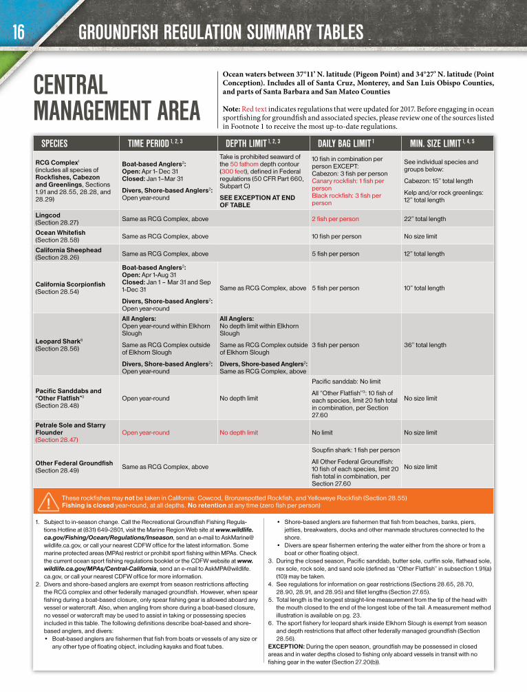
CENTRAL MANAGEMENT AREA
Ocean waters between 37°11’ N. latitude (Pigeon Point) and 34°27’ N. latitude (Point Conception). Includes all of Santa Cruz, Monterey, and San Luis Obispo Counties, and parts of Santa Barbara and San Mateo Counties
Note: Red text indicates regulations that were updated for 2017. Before engaging in ocean sportfishing for groundfish and associated species, please review one of the sources listed in Footnote 1 to receive the most up-to-date regulations.
16
GROUNDFISH REGULATION SUMMARY TABLES
SPECIES TIME PERIOD 1, 2, 3, 4 DEPTH LIMIT 1, 2, 3, 4 DAILY BAG LIMIT 1 MIN. SIZE LIMIT 1, 5, 6
RCG Complex1 (includes all species of Rockfishes, Cabezon and Greenlings, Sections 1.91 and 28.55, 28.28, and 28.29)
Boat-based Anglers2: Open: Mar 1–Dec 31 Closed: Jan 1–Feb 28
Divers, Shore-based Anglers2: Open year-round
Take is prohibited seaward of the 60 fathom depth contour (360 feet), defined in Federal regulations (50 CFR Part 660, Subpart C)
SEE EXCEPTION AT END OF TABLE
10 fish in combination per person EXCEPT: Cabezon: 3 fish per person Canary rockfish: 1 fish per person Black rockfish: 3 fish per person
See individual species and groups below:
Cabezon: 15” total length
Kelp and/or rock greenlings: 12” total length
Lingcod (Section 28.27) Same as RCG Complex, above 2 fish per person 22” total length
Ocean Whitefish (Section 28.58) Same as RCG Complex, above 10 fish per person No size limit
California Sheephead (Section 28.26) Same as RCG Complex, above 5 fish per person 12” total length
California Scorpionfish (Section 28.54)
Boat-based Anglers2: Open: Jan 1-Aug 31 Closed: Sep 1- Dec 31
Divers, Shore-based Anglers2: Open year-round
Same as RCG Complex, above 5 fish per person 10” total length
Leopard Shark7 (Section 28.56)
All Anglers: Open year-round within Newport Bay, Alamitos Bay, San Diego Bay and Mission Bay
Same as RCG Complex outside of those bays
Divers, Shore-based Anglers2: Open year-round
All Anglers: No depth limit within Newport Bay, Alamitos Bay, San Diego Bay and Mission Bay
Same as RCG Complex outside of those bays
Divers, Shore-based Anglers2: Same as RCG Complex, above
3 fish per person 36” total length
Pacific Sanddabs and “Other Flatfish”4 (Section 28.48)
Open year-round No depth limit
Pacific sanddab: No limit
All “Other Flatfish”4: 10 fish of each species, limit 20 fish total in combination, per Section 27.60
No size limit
Petrale Sole and Starry Flounder (Section 28.47)
Open year-round No depth limit No limit No size limit
Other Federal Groundfish (Section 28.49) Same as RCG Complex, above
Soupfin shark: 1 fish per person
All Other Federal Groundfish: 10 fish of each species, limit 20 fish total in combination, per Section 27.60
No size limit
These rockfishes may not be taken in California: Cowcod, Bronzespotted Rockfish, and Yelloweye Rockfish (Section 28.55) Fishing is closed year-round, at all depths. No retention at any time (zero fish per person)
1. Subject to in-season change. Call the Recreational Groundfish Fishing Regula-tions Hotline at (831) 649-2801, visit the Marine Region Web site at www.wildlife.ca.gov/Fishing/Ocean/Regulations/Inseason, send an e-mail to [email protected], or call your nearest CDFW office for the latest information. Some marine protected areas (MPAs) restrict or prohibit sport fishing within MPAs. Check the current ocean sport fishing regulations booklet or the CDFW website at www.wildlife.ca.gov/MPAs/Southern-California, send an e-mail to [email protected], or call your nearest CDFW office for more information.
2. Divers and shore-based anglers are exempt from season restrictions affecting the RCG complex and other federally managed groundfish. However, when spear fishing during a boat-based closure, only spear fishing gear is allowed aboard any vessel or watercraft. Also, when angling from shore during a boat-based closure, no vessel or watercraft may be used to assist in taking or possessing species included in this table. The following definitions describe boat-based and shore-based anglers, and divers: • Boat-based anglers are fishermen that fish from boats or vessels of any size or
any other type of floating object, including kayaks and float tubes. • Shore-based anglers are fishermen that fish from beaches, banks, piers, jetties,
breakwaters, docks and other manmade structures connected to the shore.
• Divers are spear fishermen entering the water either from the shore or from a boat or other floating object.
3. See Section 27.50 for further information on fishing regulations in the Cowcod Conservation Areas.
4. During the closed season, Pacific sanddab, butter sole, curlfin sole, flathead sole, rex sole, rock sole, and sand sole (defined as “Other Flatfish” in subsection 1.91(a)(10)) may be taken.
5. See regulations for information on gear restrictions (Sections 28.65, 28.70, 28.90, 28.91, and 28.95) and fillet lengths (Section 27.65).
6. Total length is the longest straight-line measurement from the tip of the head with the mouth closed to the end of the longest lobe of the tail. A measurement method illustration is available on pg. 23.
7. The sport fishery for leopard shark inside Newport Bay, Alamitos Bay, Mission Bay, and San Diego Bay is exempt from season and depth restrictions that affect other federally managed groundfish (Section 28.56).
EXCEPTION: During the open season, groundfish may be possessed in closed areas and in water depths closed to fishing only aboard vessels in transit with no fishing gear in the water (Section 27.20(b)).
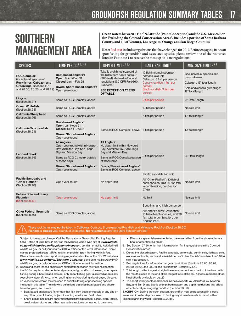
SOUTHERN MANAGEMENT AREA
Ocean waters between 34°27’ N. latitude (Point Conception) and the U.S.-Mexico Bor-der, Excluding the Cowcod Conservation Areas3. Includes a portion of Santa Barbara County, and all of Ventura, Los Angeles, Orange and San Diego Counties
Note: Red text includes regulations that have changed for 2017. Before engaging in ocean sportfishing for groundfish and associated species, please review one of the resources listed in Footnote 1 to receive the most up-to-date regulations.
17

SPECIES TIME PERIOD 3, 4 DEPTH LIMIT 3, 4 DAILY BAG LIMIT 3 MIN. SIZE LIMIT 3, 6, 7
Nearshore1 Rockfish and Shelf Rockfish2 ONLY, as defined in subsection 1.91(a)(1) and 1.91(a)(3), and Cabezon and Greenlings as defined in Sections 28.28 and 28.29
Boat-based Anglers4: Open: Mar 1-Dec 31 Closed: Jan 1–Feb 28
Divers, Shore-based Anglers4: Open year-round
Take is prohibited seaward of 20 fathoms (120 feet) in depth
SEE EXCEPTION AT END OF TABLE
10 fish in combination per person EXCEPT: Cabezon: 3 fish per person Canary rockfish: 1 fish per person Black rockfish: 3 fish per person
See individual species and groups below:
Cabezon: 15” total length
Kelp and/or rock greenlings: 12” total length
Lingcod (Section 28.27)
Same as Nearshore and Shelf Rockfishes, Cabezon, and Green-lings, above 2 fish per person 22” total length
Ocean Whitefish (Section 28.58)
Same as Nearshore and Shelf Rockfishes, Cabezon, and Green-lings, above 10 fish per person No size limit
California Sheephead (Section 28.26)
Same as Nearshore and Shelf Rockfishes, Cabezon, and Green-lings, above 5 fish per person 12” total length
California Scorpionfish (Section 28.54)
Boat-based Anglers4: Open: Jan 1- Aug 31 Closed: Sep 1- Dec 31
Divers, Shore-based Anglers4: Open year-round
Same as Nearshore and Shelf Rockfish, Cabezon, and Greenlings, above
5 fish per person 10” total length
Pacific Sanddab and “Other Flatfish”5 (Section 28.48)
Open year-round No depth limit
Pacific sanddab: No limit
All “Other flatfish”5: 10 fish of each species, limit 20 fish total in combination, per Section 27.60
No size limit
Petrale Sole and Starry Flounder (Section 28.47)
Open year-round No depth limit No limit No size limit
The groundfish species listed below may not be taken or possessed in the Cowcod Conservation Areas. Fishing is closed year-round, at all depths. No retention at any time (zero fish per person)
Cowcod, Bronzespotted and Yelloweye Rockfishes (Section 28.55)
Slope Rockfishes as defined in subsections 1.91(a)(4) Leopard Shark (Section 28.56) Other Federal Groundfish
(Sections 28.49)
1. “Nearshore rockfish” as described in subsection 1.91(a)(1) means black rock-fish, black-and-yellow rockfish, blue rockfish, brown rockfish, calico rockfish, China rockfish, copper rockfish, gopher rockfish, grass rockfish, kelp rockfish, olive rockfish, quillback rockfish, and treefish.
2. “Shelf rockfish” as described in sub-section 1.91(a)(3) mean bocaccio, canary rockfish, chilipepper rockfish, dusky rockfish, flag rockfish, greenblotched rockfish, greenspotted rockfish, greenstriped rockfish, harlequin rockfish, hon-eycomb rockfish, Mexican rockfish, pink rockfish, redstripe rockfish, rosethorn rockfish, rosy rockfish, shortbelly rockfish, silvergray rockfish, speckeled rock-fish, squarespotted rockfish, starry rockfish, stripetail rockfish, tiger rockfish, vermilion rockfish, widow rockfish, and yellowtail rockfish. Take and possession of bronzespotted rockfish, cowcod rockfish and yelloweye rockfish is prohibited.
3. Subject to in-season change. Call the Recreational Groundfish Fishing Regulations Hotline at (831) 649-2801, visit the Marine Region Web site at www.wildlife.ca.gov/Fishing/Ocean/Regulations/Inseason, send an e-mail to [email protected], or call your nearest CDFW office for the latest information. Some marine protected areas (MPAs) restrict or prohibit sport fishing within MPAs. Check the current ocean sport fishing regulations booklet or the CDFW website at www.wildlife.ca.gov/MPAs/Southern-Cal-ifornia, send an e-mail to [email protected], or call your nearest CDFW office for more information.
4. Divers and shore-based anglers are exempt from season restrictions affecting the RCG complex and other federally managed groundfish. However, when spear fishing during a boat-based closure, only spear fishing gear is allowed aboard any vessel or watercraft. Also, when angling from shore during a boat-based closure, no vessel or watercraft may be used to assist in taking or possessing species included in this table. The following definitions describe boat-based and shore-based anglers, and divers:
• Boat-based anglers are fishermen that fish from boats or vessels of any size or any other type of floating object, including kayaks and float tubes.
• Shore-based anglers are fishermen that fish from beaches, banks, piers, jetties, breakwaters, docks and other manmade structures connected to the shore.
• Divers are spear fishermen entering the water either from the shore or from a boat or other floating object.
5. In closed areas or during closed periods, Pacific sanddab, butter sole, curlfin sole, flathead sole, rex sole, rock sole, and sand sole (defined as “Other flatfish” in subsection 1.91(a)(10)) may be taken.
6. See regulations for information on gear restrictions (Sections 28.65, 28.70, 28.90, 28.91, and 28.95) and fillet lengths (Section 27.65).
7. Total length is the longest straight-line measurement from the tip of the head with the mouth closed to the end of the longest lobe of the tail. A measurement method illustration is available on pg. 23.
EXCEPTION: During the open season, groundfish may be possessed in closed areas and in water depths closed to fishing only aboard vessels in transit with no fishing gear in the water (Section 27.20(b)).
GROUNDFISH REGULATION SUMMARY TABLES
COWCOD CONSERVATION AREAS
Located in ocean waters between 34°27’ N. latitude (Point Conception) and the U.S.-Mexico Border. See map (right) and Section 27.50 for exact location coordinates. In these areas, within given depths, only the groundfish listed in this table may be taken or possessed (see exception at end of table)
Note: Red text indicates regulations that were updated for 2017. Before engaging in ocean sportfishing for groundfish and associated species, please review one of the resources listed in Footnote 3 to receive the most up-to-date regulations.
18

GROUNDFISH INFORMATION
Area 1A. 33°50’ N. Lat., 119°30’ W. Long.B. 33°50’ N. Lat., 118°50’ W. Long.C. 32°20’ N. Lat., 118°50’ W. Long.D. 32°20’ N. Lat., 119°37’ W. Long.E. 33°00’ N. Lat., 119°37’ W. Long.F. 33°00’ N. Lat., 119°53’ W. Long.G. 33°33’ N. Lat., 119°53’ W. Long.H. 33°33’ N. Lat., 119°30’ W. Long.I. 33°50’ N. Lat., 119°30’ W. Long.Area 2J. 32°42’ N. Lat., 118°02’ W. Long.K. 32°42’ N. Lat., 117°50’ W. Long.L. 32°36’42” N. Lat., 117°50’ W. Long.M. 32°30’ N. Lat., 117°53’30” W. Long.N. 32°30’ N. Lat., 118°02’ W. Long.O. 32°42’ N. Lat., 118°02’ W. Long.
This map is for informational purposes only and should not be used for navigational or legal purposes.
COWCOD CONSERVATION AREA BOUNDARY COORDINATES (FROM SECTION 27.50)
KNOW YOUR RESTRICTED GROUNDFISH... THEY CAN BE EASILY MISIDENTIFIED
ATTENTION: Juvenile Yelloweye RockfishYelloweye rockfish less than 12 in. long usually have two horizontal white stripes along the sides, which fade with age.
Body Color:Orange-red to red with dark motting
Yelloweye Rockfish
Smooth chin when rubbed back to front
Body Color:Orange-red to red
May have black-tipped fins
Rough chin and Maxillary
Vermilion Rockfish
Relatively large head and mouth
Dorsal fin has deeply notched spines
Wide gap between eye and mouth
Darker vertical bars, may fade with age
Body Color:Pink to orange-red
Cowcod
Anal fin rounded
Tail fin straight
Anal fin rounded
Body Color:Bright orange
Smooth chin and Maxillary
Black spots present on smaller fish
Canary Rockfish (Limited retention)
Anal fin slanted
Tail fin slightly forked
Thick, gray-white band extends from head to tail
For more information, please contact your local California Department of Fish and Wildlife office.
THE TAKE AND POSSESSION OF THESE GROUNDFISH ARE PROHIBITED
19
GENERAL PROVISIONS AND DEFINITIONS
CHAPTER 1: GENERAL PROVISIONS AND DEFINITIONS(Regulations seen in RED TEXT are new this year.)
All laws or regulations hereunder are either reproduced verbatim from the Fish and Game Code or from Title 14 of the California Code of Regulations (CCR), as adopted by the Fish and Game Commission under authority of the Fish and Game Code.
1.04. Anadromous Waters. Anadromous waters are inland waters that are accessible to fish migrating from the ocean.
1.05. Angling.Angling means take of fish by hook-and-line with the line held in the hand, or with the line attached to a pole or rod held in the hand or closely attended in such manner that the fish voluntarily takes the bait or lure inside its mouth.
1.14. Authorization for Taking Fish.Fish, amphibians, reptiles, mollusks and crus-taceans may be taken only in the amounts, only during the open season and only with the gear authorized and shall not be taken otherwise.
1.17. Bag and Possession Limit.No more than one daily bag limit of each kind of fish, amphibian, reptile, mollusk or crustacean named in these regulations may be taken or pos-sessed by any one person unless otherwise autho-rized; regardless of whether they are fresh, frozen, or otherwise preserved. Exceptions: See Sections 7.00, 7.50(a), 27.60(c), and 195, Title 14, CCR.
1.19. Barbless Hook.A fish hook from which the barb or barbs have been removed or completely bent closed, or which is manufactured without barbs.
1.23. Bow and Arrow Fishing Tackle. Such tackle must have the arrow shaft or the point, or both, attached by a line to the bow or to a fishing reel (includes crossbow).
1.32. Chumming. Placing any material in the water, other than on a hook while angling, for the purpose of attracting fish to a particular area in order that they may be taken.
1.35. Closed or Closure.Refers to waters or areas closed to all fishing unless otherwise authorized.
1.38. Closed Season. That period during which the taking of fish, amphibians, reptiles, mollusks or crustaceans is prohibited.
1.39. Coastal Pelagic Species Defined.Coastal pelagic species means any of the follow-ing: northern anchovy (Engraulis mordax), Pa-cific sardine (Sardinops sagax), Pacific mackerel (Scomber japonicus), jack mackerel (Trachurus symmetricus), and market squid (Loligo (Dory-teuthis) opalescens).
1.41. Dates. Dates of seasons and closures are inclusive.
1.42. Dip Net. Webbing supported by a frame, and hand held, not more than six feet in greatest dimension, excluding handle.
1.46. Finfish Defined.Finfish are defined as any species of bony fish or cartilaginous fish (sharks, skates and rays). Finfish do not include amphibians, invertebrates, plants or algae.
1.49. Highly Migratory Species Defined.Highly migratory species means any of the fol-lowing: albacore, bluefin, bigeye, and yellowfin tuna (Thunnus spp.); skipjack tuna (Katsuwonus pelamis); dorado (dolphinfish) (Coryphaena hippurus); striped marlin (Tetrapturus audax); thresher sharks (common, pelagic, and bigeye) (Alopias spp.); shortfin mako shark (Isurus oxy-rinchus); blue shark (Prionace glauca), and Pacific swordfish (Xiphias gladius).
1.53. Inland Waters.Inland waters are all the fresh, brackish and inland saline waters of the state, including lagoons and tidewaters upstream from the mouths of coastal rivers and streams. Inland waters exclude the waters of San Francisco Bay and the waters of Elkhorn Slough, west of Elkhorn Road between Castroville and Watsonville. See Section 27.00 for the description of San Francisco Bay.
1.59. Limit.Refers to daily bag limit and possession limit per person, or boat limit authorized in Sections 27.60(c) and 195, Title 14, CCR.
1.62. Minimum and Maximum Size. No fish, mollusks or crustaceans less than the legal minimum size or greater than the maximum legal size (total, fork or alternate) may be possessed, except as otherwise provided. Total length is the longest straight-line measurement from the tip of the head to the end of the longest lobe of the tail. Fork length is the straight-line distance from the tip of the head to the center of the tail fin. Tip of
the head shall be the most anterior point on the fish with the mouth closed and the fish lying flat on its side. Alternate length is the straight-line distance from the base of the foremost spine of the first dorsal fin to the end of the longest lobe of the tail. Unless otherwise provided, all fish, mollusks or crustaceans less than the legal minimum size or greater than the maximum legal size must be returned immediately to the water from which they were taken. (Note: See Invertebrate section for definitions of minimum legal size for mollusks and crustaceans.)
1.63. Movement of Live Fish.Except as provided in Sections 4.00 through 4.30 and 230, live fin fish may not be transported alive from the water where taken.
1.65. Multiple Hook. A hook with two or more points.
1.68. Open Season.That period of time during which the taking of fish, amphibians, reptiles, mollusks and crusta-ceans is authorized.
1.70. Opening Date and Bag Limit for Boundary Waters.Waters, exclusive of their tributaries, on the boundary between areas or districts with different opening dates or limits shall open on the earlier date and have the larger limit unless otherwise specified.
1.72. Stream (Includes Creeks and Rivers).A stream is a body of water that flows at least periodically or intermittently through a bed or channel having banks and that supports fish or other aquatic life. This includes watercourses having a surface or subsurface flow that supports or has supported riparian vegetation.
1.73. Salmon. (a) Salmon includes Chinook, coho, pink, chum,
and sockeye salmon.(b) Any person in possession of a recreationally
taken salmon with a missing adipose fin (the small, fleshy fin on the back of the fish between the back fin and tail) shall immediately relin-quish the head of the salmon, upon request by an authorized agent or employee of the department, to facilitate the recovery of any coded-wire tag. The head may be removed by the fish owner or, if removed by the official department representative, the head shall be removed in a manner to minimize loss of salmon flesh and the salmon shall immedi-ately be returned to the fish owner.
1.74. Sport Fishing Report Card and Tagging Requirements.(a) Purpose. These regulations are designed to
improve recreational fishing effort and catch information in some or all areas where the fisheries operate. Many of these species are of
20
2017–2018 CALIFORNIA SALTWATER FISHING REGULATIONS

GENERAL PROVISIONS AND DEFINITIONS
high commercial value, and therefore, addi-tional enforcement mechanisms are needed to improve compliance with existing bag limits and other regulations, and to reduce the po-tential for poaching.
(b) Report card requirements apply to any person fishing for or taking the following species regardless of whether a sport fishing license is required:(1) Salmon, in the anadromous waters of
the Klamath, Trinity, and Smith river basins. Anadromous waters are defined in Section 1.04 of these regulations.
(2) Steelhead trout.(3) White sturgeon.(4) Red abalone.(5) California spiny lobster.
(c) General Report Card Requirements.(1) Any person fishing for or taking any of
the species identified in this Section shall have in his immediate possession a valid non-transferable report card issued by the department for the particular species. See special exemption regarding posses-sion of report cards for lobster divers in Section 29.91 of these regulations.
(2) All entries made on any report card or tag shall be legible and in indelible ink.
(3) A report card holder fishing with a one, two, or ten-day sport fishing license, may replace the expired fishing license with-out purchasing a new report card so long as the report card is still valid.
(4) Report cards are not transferable and shall not be transferred to another per-son. No person shall possess any report card other than his own.
(5) A person may only obtain one abalone report card and one sturgeon report card per report card period.
(6) Any report card holder who fills in all available lines on his steelhead, salmon or lobster report card shall return or report the card to the department pursuant to subsection 1.74(e) prior to purchasing a second card.
(7) Data recording and tagging procedures vary between report cards and species. See specific regulations in sections 5.79, 5.87, 5.88, 27.92, 29.16, and 29.91 that apply in addition to the regulations of this Section.
(d) Report Card Return and Reporting Require-ments(1) Report card holders shall return or re-
port their salmon, steelhead, sturgeon, or abalone report cards to the department pursuant to subsection 1.74(e) by January 31 of the following year.(A) Any report card holder who fails to
return or report his salmon, steel-head, sturgeon, or abalone report card to the department by the dead-line may be restricted from obtaining the same card in a subsequent license year or may be subject to an addition-
al fee for the issuance of the same card in a subsequent license year.
(2) Report card holders shall return or report their lobster report cards pursuant to subsection 1.74(e) by April 30 following the close of the lobster season for which the card was issued.(A) Any report card holder who fails to
return or report his or her lobster report card by April 30 following the close of the lobster season spec-ified on the card shall be subject to a nonrefundable non-return fee specified in Section 701, in addition to the annual report card fee, for the issuance of a lobster report card in the subsequent fishing season.
(e) Report Card Return and Reporting Mecha-nisms:(1) By mail or in person at the address spec-
ified on the card. A report card returned by mail shall be postmarked by the date applicable to that card as specified in subsection 1.74(d)(1) or 1.74(d)(2).
(2) Online through the department’s license sales service website by the date applica-ble to that card as specified in subsection 1.74(d)(1) or 1.74(d)(2).
(3) If a report card is submitted by mail and not received by the department, it is considered not returned unless the report card holder reports his or her report card as lost pursuant to subsection 1.74(f).
(f) Lost report cards.(1) Any report card holder who loses his re-
port card shall submit an affidavit, signed under penalty of perjury, in person to a department license sales office contain-ing all of the following information:(A) A statement containing the report
card holder’s full name confirming that the originally issued report card cannot be recovered.
(B) A statement containing the report card holder’s best recollection of the prior catch records that were entered on the report card that was lost.
(C) A statement describing the factual circumstances surrounding the loss of the card.
(2) An affidavit for a lost report card shall be presented at a department license sales office, by the date applicable to that card specified in subsection 1.74(d)(1) or 1.74(d)(2) to be considered returned.
(3) Notwithstanding subsection 1.74(c)(5), any report card holder who loses his re-port card during the period for which it is valid may replace the lost report card by submitting an affidavit as described in subsection 1.74(f)(1) and payment of the report card fee and replacement pro-cessing fee specified in Section 701.(A) Based on the information provided
in the written affidavit for abalone
and sturgeon report cards, the de-partment shall issue only the num-ber of tags that were reported unused on the previously issued report card.
1.76. Spearfishing.The taking of fish by spear or hand by persons who are in the water and may be using underwa-ter goggles, face plates, breathing tubes, SCUBA or other artificial underwater breathing device.
1.80. Take.Hunt, pursue, catch, capture or kill fish, amphib-ians, reptiles, mollusks, crustaceans or inverte-brates or attempting to do so.
1.84. Titles and Section Numbers.All titles and headings used in these regulations are a part thereof. All section numbers cited refer to these regulations unless otherwise specified.
1.87. Waste of Fish.It is unlawful to cause or permit any deterioration or waste of any fish taken in the waters of this state.
1.88. Public Pier.A public pier is a publicly owned man-made structure that has the following characteristics: is connected, above the mean high tide, to the main coastline or to the landmass of a named and charted natural island; has unrestricted free access for the general public; and has been built or currently functions for the primary purpose of allowing angling access to ocean waters.
Additionally, publicly owned jetties or breakwa-ters that are connected to land, as described above, that have free unrestricted access for the general public and whose purpose it is to form the most seaward protective boundary of an ocean harbor are public piers. Jetties, breakwaters, promenades, sea walls, moles, docks, linings, barriers and other structures that are not the most seaward protective boundary of an ocean harbor, are not public piers.
1.90. Nearshore Fish Stocks, Nearshore Fisheries, Nearshore Waters, and Shallow Nearshore Rockfish Defined.(a) Under the authority of Section 8587.1 of the
Fish and Game Code, Section 8586 of the Fish and Game Code is made inoperative.
(b) “Nearshore fish stocks” means any of the following: (1) black rockfish (Sebastes melanops), (2) black-and-yellow rockfish (Sebastes
chrysomelas), (3) blue rockfish (Sebastes mystinus), (4) brown rockfish (Sebastes auriculatus), (5) cabezon (Scorpaenichthys marmoratus), (6) calico rockfish (Sebastes dallii),(7) California scorpionfish (sculpin) (Scor-
paena guttata),(8) California sheephead (Semicossyphus
pulcher), (9) China rockfish (Sebastes nebulosus),(10) copper rockfish (Sebastes caurinus),
21
2017–2018 CALIFORNIA SALTWATER FISHING REGULATIONS

GENERAL PROVISIONS AND DEFINITIONS
(11) gopher rockfish (Sebastes carnatus), (12) grass rockfish (Sebastes rastrelliger), (13) greenlings of the genus Hexagrammos, (14) kelp rockfish (Sebastes atrovirens), (15) monkeyface eel (Cebidichthys violaceus), (16) olive rockfish (Sebastes serranoides), (17) quillback rockfish (Sebastes maliger), and (18) treefish (Sebastes serriceps).
(c) “Nearshore fisheries” means the commercial or recreational taking, possession, or landing of any species of nearshore fish stocks.
(d) “Nearshore waters” means ocean waters includ-ing around offshore rocks and islands extend-ing from the shore to a depth of 20 fathoms.
(e) “Shallow nearshore rockfish” means a sub-group of rockfishes (genus Sebastes) includ-ing only black-and-yellow rockfish, China rockfish, gopher rockfish, grass rockfish, and kelp rockfish.
1.91. Federal Groundfish and Rockfish, Cabezon and Greenling (RCG) Complex. (a) The species or species groups listed in subsec-
tions 1.91(a)(1) through 1.91(a)(12) constitute “federal groundfish” and are managed under the Federal Pacific Coast Groundfish Fishery Management Plan:(1) “Nearshore Rockfish,” which means
the following species of rockfish: black rockfish (Sebastes melanops), black and yellow rockfish (S. chrysomelas), blue rockfish (S. mystinus), brown rockfish (S. auriculatus), calico rockfish (S. dalli), China rockfish (S. nebulosus), copper rockfish (S. caurinus), gopher rockfish (S. carnatus), grass rockfish (S. rastrelliger), kelp rockfish (S. atro-virens), olive rockfish (S. serranoides), quillback rockfish (S. maliger), treefish (S. serriceps)
(2) “California Scorpionfish” (Scorpaena guttata)
(3) “Shelf Rockfish” which means the follow-ing species of rockfish: bocaccio (Sebastes paucispinis), bronzespotted rockfish (S. gilli), canary rockfish (S. pinniger), chilipepper (S. goodei), cowcod (S. levis), dusky rockfish (S. ciliatus), flag rockfish (S. rubrivinctus), greenblotched rockfish (S. rosenblatti), greenspotted rockfish (S. chlorostictus), greenstriped rockfish (S. elongatus), harlequin rockfish (S. varie-gatus), honeycomb rockfish (S. umbro-sus), Mexican rockfish (S. macdonaldi), pink rockfish (S. eos), redstripe rockfish (S. proriger), rosethorn rockfish (S. hel-vomaculatus), rosy rockfish (S. rosaceus), shortbelly rockfish (S. jordani), silvergray rockfish (S. brevispinis), speckled rock-fish (S. ovalis), squarespot rockfish (S. hopkinsi), starry rockfish (S. constellatus), stripetail rockfish (S. saxicola), tiger rock-fish (S. nigrocinctus), vermilion rockfish (S. miniatus), widow rockfish (S. entome-las), yelloweye rockfish (S. ruberrimus), yellowtail rockfish (S. flavidus)
(4) “Slope Rockfish” which means the following species of rockfish: aurora rockfish (Sebastes aurora), bank rock-fish (S. rufus), blackgill rockfish (S. mel-anostomus), darkblotched rockfish (S. crameri), Pacific ocean perch (S. alu-tus), redbanded rockfish (S. babcoc-ki), rougheye rockfish (S. aleutianus), sharpchin rockfish (S. zacentrus), shor-traker rockfish (S. borealis), splitnose rockfish (S. diploproa), yellowmouth rockfish (S. reedi)
(5) “Sharks”, including only leopard shark (Triakis semifasciata), soupfin shark (Galeorhinus galeus), and spiny dogfish (Squalus acanthias)
(6) “Skates”, which means big skate (Raja binoculata), California skate (R. inor-nata), and longnose skate (R. rhina), roughtail/black skate (Bathyraja trachu-ra), Aleutian skate (B. aleutica), Bering/sandpaper skate (R. interrupta) and all other genera and species of skates in the families Arhynchobatidae and Rajidae that occur off California
(7) “Roundfish”, including only cabezon (Scorpaenichthys marmoratus), kelp greenling (Hexagrammos decagrammus), lingcod (Ophiodon elongatus), Pacific cod (Gadus macrocephalus), Pacific whit-ing (Merluccius productus), and sablefish (Anoplopoma fimbria)
(8) “Thornyheads”, which means longspine thornyhead (Sebastolobus altivelis), and shortspine thornyhead (Sebastolobus alascanus)
(9) “Federally Managed Flatfish”, including only arrowtooth flounder (arrowtooth turbot) (Atheresthes stomias), Dover sole (Microstomus pacificus), English sole (Pa-rophrys vetulus), petrale sole (Eopsetta jordani), and starry flounder (Platichthys stellatus)
(10) “Other Flatfish”, including only but-ter sole (Isopsetta isolepis), curlfin sole (Pleuronichthys decurrens), f lathead sole (Hippoglossoides elassodon), Pacif-ic sanddab (Citharichthys sordidus), rex sole (Glyptocephalus zachirus), rock sole (Lepidopsetta bilineata), and sand sole (Psettichthys melanostictus)
(11) “Other fish”, including only ratfish (Hydrolagus colliei), finescale codling (Antimora microlepis), Pacific grenadier (rattail) (Coryphaenoides acrolepis) and all other genera and species of grenadiers in the family Macrouridae that occur off California
(12) All genera and species of the family Scor-paenidae that occur off California and not specifically listed in (a)(1) through (a)(4) or (a)(8) above
(b) “RCG Complex” means all species of rockfish (Sebastes), cabezon (Scorpaenichthys marmor-atus), and kelp and rock greenlings (genus Hexagrammos).
195. Report of Fish Taken to be Made by Owner of Barge or Vessel for Hire and Boat Limits. (a) Records required by Sections 7923 and 8026
of the Fish and Game Code shall be made on forms provided by the department entitled COMMERCIAL PASSENGER FISHING VESSEL LOG, CENTRAL AND NORTHERN CALIFORNIA, DFW 195A (02/13), or COM-MERCIAL PASSENGER FISHING VESSEL LOG, SOUTHERN CALIFORNIA, DFW 195B (02/13), see Appendix A, and hereafter referred to as logbook for purposes of this sec-tion. The logbook shall include the following information and be completed and available for inspection as specified in this section: (1) A full and correct record of fish taken, in-
cluding species or specified species groups, filled out before the trip is completed as provided in Section 190(b). The names used for designating the species of fish shall be those in common usage unless otherwise designated by the department. (A) Form DFW 195A shall be used when
the vessel is engaged in fishing north of Point Conception.
(B) Form DFW 195B shall be used when the vessel is engaged in fishing south of Point Conception.
(2) The owner/operator copy of the logbook shall be maintained and kept on the ves-sel for a period of one year, and upon request, shall be made available for in-spection by any authorized representative of the Department.
(3) The numbered logbook shall be complet-ed sequentially. A voided log shall have the word “Void” plainly and noticeably written on the face of the log.
(4) For months when no fishing activity occurred, a log shall be completed on the last day of the month with an entry made clearly indicating that no fishing activity occurred for the month specified by the owner/operator. All logs shall be kept and delivered to the department as specified in Section 190.
(5) A commercial passenger fishing vessel shall keep and submit logbooks whether or not the fishing trip involves paying or non-paying anglers.
(b) The owner(s) and/or operator(s) of each vessel required to obtain a license under Section 7920 of the Fish and Game Code shall post a notice in a prominent place on the vessel giving informa-tion to fishermen on license requirements, bag limits, and other pertinent information. This notice shall be furnished by the department.
(c) Both the vessel owner(s) and/or operator(s) shall be responsible for keeping accurate re-cords and insuring the vessel is in compliance with sub-sections (a) and (b) above.
(d) All fishing activity records are confidential pursuant to Fish and Game Code Sections 7923 and 8022 and Government Code Sec-tions 6276 and 6276.10.
22
2017–2018 CALIFORNIA SALTWATER FISHING REGULATIONS
GENERAL PROVISIONS AND DEFINITIONS
(e) Boat Limits: When two or more persons li-censed or otherwise authorized to sport fish in ocean waters off California or in the San Francisco Bay District, as defined in Section 27.00, are angling for finfish in these waters aboard a vessel licensed under Section 7920, fishing by these persons (to include vessel operator(s) and crew members where licensed to sportfish under their own individual limits) may continue until the passenger’s boat limits of those finfish are taken and possessed aboard the vessel as authorized under this section. (1) For purposes of this section, the vessel
operator(s) and crew members are not passengers and may not take fish towards obtaining boat limits for passengers ex-cept for casting, setting trolling gear, gaffing or netting fish, but may take fish during a fishing trip for their personal use only. Vessel operator(s) and crew members may assist passengers in other activities including, but not limited to, obtaining bait, chumming, baiting and untangling hooks and lines, identifying, dispatching, filleting, counting, bagging and otherwise handling fish taken by passengers. Upon completion of a fish-ing trip, the vessel operator(s) and crew members may only possess fish that are part of their own personal bag limit not to exceed authorized sportfishing daily bag and possession limits.
(2) Fish taken by operator(s) and crew mem-bers for personal use pursuant to (e)(1) above must be separated from fish tak-en under a boat limit and labeled in a manner that they can be identified as an individual operator’s or crew members fish. Operator(s) and crew members are also prohibited from giving all or part of their individual limit to any passenger during or after a trip.
(3) The authorization for boat limits aboard a vessel does not apply to fishing trips originating in California where fish are taken in other jurisdictions.
(4) A boat limit for a species or species group is equal to the number of passen-gers aboard the vessel that are licensed or otherwise authorized to sport fish in ocean waters off California or in the San Francisco Bay District multiplied by the individual daily bag limit authorized for a species or species group. For purposes of this section, the number of passengers shall not include the vessel operator(s) and crew members. It is unlawful to ex-ceed the boat limit at any time.
(5) Prior to the departure on a fishing trip of a vessel that is licensed under Fish and Game Code Section 7920, the number of fishers, to include passengers, guests, op-erators and crew who will be fishing, shall be recorded under “number of fishers” on the logbook for that trip. In addition, the number of vessel operator(s) and crew
members who will fish for that trip shall be recorded in the space to the right of the operator’s signature on the logbook.
(6) Upon completion of a sport fishing trip aboard a vessel reporting under this sec-tion, each licensed or otherwise autho-rized angler may not possess more than the daily bag and possession limits. For the purposes of this section, a fishing trip is completed at the time a person dis-embarks from the vessel and individual possession limits apply.
(7) Species for which no daily bag limit exists are not included in the boat limit.
(f) Where boat limits are provided for in this section, the vessel operator(s) and crew mem-bers may be cited for violations occurring aboard the vessel, including but not limited to violations of the following: (1) Overlimits (2) Possession of prohibited species (3) Minimum size limits (4) Fish taken out of season or in closed areas
(g) Boat limits are not authorized for sturgeon fishing and shall not apply to the take, pos-session or retention of sturgeon.
MEASUREMENT METHODS
ALTERNATE LENGTH: Base of foremost spine of dorsal fin, to longest tip of tail.
Pacific bonito
California spiny lobster
Dungeness crab Pismo clam
FORK LENGTH (FL): Tip of head with mouth closed, to fork of tail.
TOTAL LENGTH (FL): Tip of head with mouth closed, to longest tip of tail.
METHOD FOR CLAMS AND ABALONEGreatest shell diameter
See Section 29.90(C)
See Section 29.85(a)(7) & 29.85(b)(3)
TAIL
CARAPACE
CDFW Artwork
23
2017–2018 CALIFORNIA SALTWATER FISHING REGULATIONS
OCEAN FISHING
CHAPTER 4: OCEAN FISHING27.00. Definition.The Ocean and San Francisco Bay District con-sists of the Ocean and San Francisco Bay, as described herein. The Ocean is the open seas adjacent to the coast and islands and the wa-ters of open or enclosed bays contiguous to the ocean, including the waters of Elkhorn Slough, west of Elkhorn Road between Castroville and Watsonville. San Francisco Bay is the waters of San Francisco and San Pablo bays plus all their tidal bays, sloughs, estuaries, and tidal portions of their rivers and streams between the Golden Gate Bridge and the west Carquinez Bridge. For purposes of this section, waters downstream of the Trancas Bridge on the Napa River, down-stream of the Highway 121 Bridge on Sonoma Creek, and downstream of the Payran Street Bridge on the Petaluma River are tidal portions of the Napa River, Sonoma Creek, and Petaluma River, respectively. Also see Section 1.53.
27.05. Chumming.Chumming, including chumming with live bait, is permitted.
27.10. Live Bait Restrictions.Tilapia may not be used or possessed for use as bait in ocean waters.
27.15. Multi-Day Fishing Trips.The following provisions apply to anglers and to boat owners and operators when a Declaration for a Multi-Day Fishing Trip has been filed with the department.(a) Provisions related to the angler: Up to three
daily bag and possession limits of saltwater fin fish, lobster and rock scallops and up to two daily bag and possession limits of abalone are allowed for a person fishing during a multi-day trip in ocean waters from a boat whose owner or operator has filed a Declaration for Multi-Day Fishing Trip, pursuant to the provisions of sub-section (b) below.(1) The provisions of this section do not au-
thorize any person to take more than one daily bag limit of fish during one calendar day.
(2) The provisions of this section do not apply to the taking and possession of salmon, steelhead, striped bass and sturgeon.
(b) Provisions related to the boat owner or op-erator who has filed for a Declaration for a Multi-Day Fishing Trip:(1) The owner or operator of a boat shall sub-
mit to the nearest department office a Dec-laration for Multi-Day Fishing Trip and payment as specified in Section 701. The Declaration for Multi-Day Fishing Trip shall include the following information: (A) Place, date and time of departure of
the boat.
(B) Place, date and estimated time of return of the boat.
(C) Name of the boat. (D) Date and hour Declaration mailed
or delivered to the department. (E) Additional requirements for Com-
mercial Passenger Fishing Vessels: 1.The Commercial Boat Registration Number issued pursuant to Fish and Game Code Section 7880.2. Copy of passenger manifest if fish-ing within 10 miles of the mainland shore of California.
(2) The Declaration for Multi-Day Fishing Trip must be submitted to the nearest department office in order for any person aboard such boat to possess more than one bag limit of saltwater fin fish, abalo-ne, lobster and rock scallops. If mailed, the Declaration for Multi-Day Fishing Trip must be received at least 48 hours prior to the date of the boat’s departure. If the 48-hours advance notice is not met, the original copy of the form signed by an authorized department representative must be aboard the vessel during the trip. Forms will be accepted for authorization only during business hours of 8:00 a.m. to 5:00 p.m.
(3) A Declaration for Multi-Day Fishing Trip may not be filed for a trip unless the trip is continuous and extends for a period of 12 hours or more on the first and last days of the trip and no berthing or docking is permitted within five miles of the mainland shore.
(4) The owner or operator of a boat filing a Declaration for Multi-Day Fishing Trip shall prepare such form in duplicate, and shall require the duplicate to be posted in full view of the passengers aboard the boat.
(5) All passengers must disembark at place of return as stated on the Declaration for Multi-Day Fishing Trip.
FIN FISH — GENERAL27.56. Take General.Except as otherwise provided, there are no closed seasons, closed hours or minimum size limits on fin fish in the Pacific Ocean including all saltwater bays except that in San Francisco Bay between the Golden Gate Bridge and the Carquinez Bridge and in saltwater tributaries to the bay within the area bounded by Interstate 80 and Highways 17, 101 and 37 finfish may not be taken between one hour after sunset to one hour before sunrise except from shore or piers.
FIN FISH — MINIMUM SIZE LIMITS, BAG AND POSSESSION LIMITS, AND SEASONS27.20. Groundfish Management Areas, Seasons, Depths, Exceptions, and Fishery Closure/Rule Change Process Described.Regulations that follow in sections 27.25 through 27.50 define fishing seasons and depth constraints that are effective within each Groundfish Manage-ment Area. These sections apply to take and pos-session of federally-managed groundfish species as defined in Section 1.91 and California sheephead, ocean whitefish, and all greenlings of the genus Hexagrammos, which are state-managed species known to associate with federal groundfish.(a) Depth Constraints: A depth constraint means
that during the open season, the aforemen-tioned species may not be taken or possessed in water depths deeper than the specified depth. Two specific definitions of “depth” apply off California. In waters shallower than 30 fath-oms, “depth” is defined by general depth con-tour lines. In waters equal to or deeper than 30 fathoms, “depth” is defined by approximating a particular depth contour by connecting the appropriate set of waypoints adopted in Fed-eral regulations (50 CFR Part 660, Subpart C).
(b) General Provisions.(1) Take and Possession: During any open
season in any Groundfish Management Area, in waters deeper than where fishing is authorized or within special closure areas established within a Groundfish Management Area, it is unlawful to take or possess the aforementioned species except as provided in subsections (b)(1)(A) through (b)(1)(D) below and sections 27.25 through 27.50 of these regulations. (A) Transit: The aforementioned species
may be possessed aboard a vessel in transit through a closed area with no fishing gear deployed in the water.
(B) “Other Flatfish” as defined in sub-section 1.91(a)(10), petrale sole and starry flounder may be taken or pos-sessed in all depths year-round.
(C) Shore Based Angling: When angling from shore (includes beaches, banks, piers, jetties, breakwaters, docks, and other man-made structures connect-ed to the shore), all species may be taken or possessed year-round (See 27.50(b)(1) for exceptions in the Cowcod Conservation Areas). No vessel or watercraft (motorized or non-motorized) may be used to assist in taking or possessing these spe-cies while angling from shore under this provision.
24
2017–2018 CALIFORNIA SALTWATER FISHING REGULATIONS

OCEAN FISHING
(D) Diving or Spearfishing: When div-ing or spearfishing, as authorized in Section 28.90, all species may be taken or possessed year-round (See 27.50(b)(2)) for exceptions in the Cowcod Conservation Areas). When boat-based groundfish fishing is closed, all types of fishing gear, ex-cept spearfishing gear, are prohibited to be aboard the vessel or watercraft (motorized or non-motorized) while spearfishing for the purpose of tak-ing or possessing these species under this provision.
(c) Closed Season: During any closed season in any Groundfish Management Area, it is unlawful to take or possess the aforemen-tioned species regardless of depth, except as provided in subsections (b)(1)(A) through (b)(1)(D) above and sections 27.25 through 27.50 of these regulations.
(d) California Rockfish Conservation Area: With-in any Groundfish Management Area, waters that are closed for these species during spec-ified times and/or closed in specified depths shall be known as the California Rockfish Conservation Area. See Section 27.51.
(e) Fishery closure and/or rule change: When the department determines, based on the best available scientific information, that an annual harvest limit [optimum yield (OY), annual catch limit (ACL), annual catch tar-get (ACT), recreational harvest guideline, or recreational harvest target] established in regulation by the NOAA Fisheries (National Marine Fisheries Service) for any species of federally-managed groundfish or aggregate group of federal groundfish species has been exceeded or is projected to be exceeded prior to the end of the year or that catches are less than predicted, the following rule changes may occur:(1) The department may modify the sea-
sons and/or depth constraints for any species of federally-managed groundfish or aggregate group of federal ground-fish species, California sheephead, ocean whitefish, and all greenlings of the ge-nus Hexagrammos. Season and/or depth modifications may differ by Groundfish Management Area, time of year, mode of fishing, or gear utilized.
(2) The department may adjust existing bag or sub-bag limits or establish additional bag or sub-bag limits as needed for any species of federally-managed groundfish or aggregate group of federal ground-fish species, California sheephead, ocean whitefish, and all greenlings of the genus Hexagrammos. Bag limits may differ by Groundfish Management Area, time of year, mode of fishing, or gear utilized.
(3) The department may adjust existing size limits or establish additional size limits as needed for any species of federally-man-aged groundfish or aggregate group of
federal groundfish species, California sheephead, ocean whitefish, and all greenlings of the genus Hexagrammos. Size limits may differ by Groundfish Management Area, time of year, mode of fishing, or gear utilized.
(f ) Notice of closure and/or rule change: The department shall give the public and the NOAA Fisheries no less than 10 calendar days’ notice of any fishery closure or rule change implemented pursuant to this Section via a department news release. Anglers and divers are advised to check the current rules before fishing. The latest fishing rules may be found on the department’s website at: www.wildlife.ca.gov/regions/marine or by calling (831) 649-2801 for recorded information, or by contacting a department office.
27.25. Northern Groundfish Management Area.This Section applies to take and possession of fed-erally-managed groundfish species as defined in Section 1.91, California sheephead, ocean white-fish, and all greenlings of the genus Hexagram-mos. For specific definitions, applicability, and procedures, see sections 1.91 and 27.20. For size limits, possession limits, and other regulations that apply to individual species, see specific sec-tions beginning with Section 27.60.(a) The Northern Groundfish Management Area
means ocean waters between 42° 00’ N. lat. (the Oregon/California border) and 40° 10’ N. lat. (near Cape Mendocino, Humboldt County).
(b) Seasons and depth constraints (except as provided in subsection (c) below):(1) January 1 through April 30: Closed. (2) May 1 through October 31: Take of all
species is prohibited seaward of a line approximating the 30-fathom depth contour along the mainland coast and along islands and offshore seamounts. The 30-fathom depth contour is de-fined by straight lines connecting the set of 30-fathom waypoints as adopted in Federal regulations (50 CFR Part 660, Subpart G).
(3) November 1 through December 31: Open for all species with no depth restrictions.
(c) Leopard shark may be taken or possessed in Humboldt Bay year-round.
27.30. Mendocino Groundfish Management Area. This Section applies to take and possession of fed-erally-managed groundfish species as defined in Section 1.91, California sheephead, ocean white-fish, and all greenlings of the genus Hexagram-mos. For specific definitions, applicability, and procedures, see sections 1.91 and 27.20. For size limits, possession limits, and other regulations that apply to individual species, see specific sec-tions beginning with Section 27.60.(a) The Mendocino Groundfish Management
Area means ocean waters between 40° 10’
N. lat. (near Cape Mendocino, Humboldt County) and 38° 57.50’ N. lat. (at Point Arena, Mendocino County).
(b) Seasons and depth constraints (except as provided in subsection (c) below):(1) January 1 through April 30: Closed.(2) May 1 through October 31: Take of all
species is prohibited seaward of 20 fath-oms in depth as described by general depth contour lines along the mainland coast and along islands and offshore sea-mounts.
(3) November 1 through December 31: Open for all species with no depth restrictions.
(c) California scorpionfish (1) May 1 through August 31: Take is pro-
hibited seaward of 20 fathoms in depth as described by general depth contour lines along the mainland coast and along islands and offshore seamounts.
(2) September 1 through December 31: Closed.
27.35. San Francisco Groundfish Management Area. This Section applies to take and possession of fed-erally-managed groundfish species as defined in Section 1.91, California sheephead, ocean white-fish, and all greenlings of the genus Hexagram-mos. For specific definitions, applicability, and procedures, see sections 1.91 and 27.20. For size limits, possession limits, and other regulations that apply to individual species, see specific sec-tions beginning with Section 27.60.(a) The San Francisco Groundfish Management
Area means ocean waters between 38° 57.50’ N. lat. (at Point Arena, Mendocino County) and 37° 11’ N. lat. (at Pigeon Point, San Mateo County).
(b) Seasons and depth constraints (except as provided in subsection (c) below):(1) January 1 through April 14: Closed. (2) April 15 through December 31: Take
of all species is prohibited seaward of a line approximating the 40-fathom depth contour along the mainland coast and along islands and offshore seamounts. The 40-fathom depth contour is de-fined by straight lines connecting the set of 40-fathom waypoints as adopted in Federal regulations (50 CFR Part 660, Subpart G).
(c) Special exceptions to subsection (b) above:(1) Leopard shark may be taken or possessed
in Drake’s Bay, Bolinas Bay, Tomales Bay, Bodega Harbor, and San Francisco Bay year-round.
(2) California scorpionfish (A) April 15 through August 31: Take is
prohibited seaward of a line approxi-mating the 40-fathom depth contour along the mainland coast and along islands and offshore seamounts. The 40-fathom depth contour is defined by straight lines connecting the set of 40-fathom waypoints as adopted
25
2017–2018 CALIFORNIA SALTWATER FISHING REGULATIONS

OCEAN FISHING
in Federal regulations (50 CFR Part 660, Subpart G).
(B) September 1 through December 31: Closed.
27.40. Central Groundfish Management Area. This Section applies to take and possession of fed-erally-managed groundfish species as defined in Section 1.91, California sheephead, ocean white-fish, and all greenlings of the genus Hexagram-mos. For specific definitions, applicability, and procedures, see sections 1.91 and 27.20. For size limits, possession limits, and other regulations that apply to individual species, see specific sec-tions beginning with Section 27.60.(a) The Central Groundfish Management Area
means ocean waters between 37° 11’ N. lat. (at Pigeon Point, San Mateo County) and 34° 27’ N. lat (at Point Conception, Santa Barbara County).
(b) Seasons and depth constraints (except as provided in subsection (c) below): (1) January 1 through March 31: Closed. (2) April 1 through December 31: Take of
all species is prohibited seaward of a line approximating the 50-fathom depth contour along the mainland coast and along islands and offshore seamounts. The 50-fathom depth contour is de-fined by straight lines connecting the set of 50-fathom waypoints as adopted in Federal regulations (50 CFR Part 660, Subpart G).
(c) Special exceptions to subsection (b) above:(1) Leopard shark may be taken or possessed
in Elkhorn Slough year-round. (2) California scorpionfish
(A) April 1 through August 31: Take is prohibited seaward of a line approxi-mating the 50-fathom depth contour along the mainland coast and along islands and offshore seamounts. The 50-fathom depth contour is defined by straight lines connecting the set of 50-fathom waypoints adopted in Federal regulations (50 CFR Part 660, Subpart G).
(B) September 1 through December 31: Closed.
27.45. Southern Groundfish Management Area.This Section applies to take and possession of fed-erally-managed groundfish species as defined in Section 1.91, California sheephead, ocean white-fish, and all greenlings of the genus Hexagram-mos. For specific definitions, applicability, and procedures, see sections 1.91 and 27.20. For size limits, possession limits, and other regulations that apply to individual species, see specific sec-tions beginning with Section 27.60.(a) The Southern Groundfish Management Area
means ocean waters between 34° 27’ N. lat. (at Point Conception, Santa Barbara County) and the U.S./Mexico border. The Cowcod
Conservation Areas are special closure areas within the Southern Groundfish Management Area.
(b) Seasons and depth constraints (except as provided in subsection (c) below)(1) January 1 through the last day in Febru-
ary: Closed. (2) March 1 through December 31: Take
of all species is prohibited seaward of a line approximating the 60-fathom depth contour along the mainland coast and along islands and offshore seamounts. The 60-fathom depth contour is de-fined by straight lines connecting the set of 60-fathom waypoints as adopted in Federal regulations (50 CFR Part 660, Subpart G).
(c) Special exceptions to subsection (b) above:(1) Regulations that apply to the Cowcod
Conservation Areas are specified in Sec-tion 27.50.
(2) Leopard shark may be taken or possessed in Newport Bay, Alamitos Bay, Mission Bay, and San Diego Bay year-round.
(3) California scorpionfish (A) January 1 throught August 31: Take
is prohibited seaward of a line ap-proximating the 60-fathom depth contour along the mainland coast and along islands and offshore seamounts. The 60-fathom depth contour is defined by straight lines connecting the set of 60-fathom waypoints as adopted in Federal regulations (50 CFR Part 660, Sub-part G).
(B) September 1 through December 31: Closed.
27.50. Cowcod Conservation Areas. This Section applies to take and possession of federally-managed groundfish species as defined in Section 1.91, California sheephead, ocean white-fish, and all greenlings of the genus Hexagram-mos. For specific definitions, applicability, and procedures, see sections 1.91 and 27.20. For size limits, possession limits, and other regulations that apply to individual species, see specific sections beginning with Section 27.60.(a) The Cowcod Conservation Areas are defined
as ocean waters off southern California within each of the following two areas:
Area 1 is an area south of Point Conception that is bound by straight lines connecting the following points in the order listed:33° 50’ N. lat., 119° 30’ W. long.;33° 50’ N. lat., 118° 50’ W. long.;32° 20’ N. lat., 118° 50’ W. long.;32° 20’ N. lat., 119° 37’ W. long.;33° 00’ N. lat., 119° 37’ W. long.;33° 00’ N. lat., 119° 53’ W. long.;33° 33’ N. lat., 119° 53’ W. long.;33° 33’ N. lat., 119° 30’ W. long.; and 33° 50’ N. lat., 119° 30’ W. long.
Area 2 is a smaller area west of San Diego that is bound by straight lines connecting the following points in the order listed:32° 42’ N. lat., 118° 02’ W. long.;32° 42’ N. lat., 117° 50’ W. long.;32° 36’ 42’N. lat., 117° 50’ W. long.;32° 30’ N. lat., 117° 53’ 30. W. long.;32° 30’ N. lat., 118° 02’ W. long.; and32° 42’ N. lat., 118° 02’ W. long.
(b) Seasons and depth constraints (except as pro-vided in subsection (c) below):(1) January 1 through the last day in Febru-
ary: Closed. (2) March 1 through December 31: Open for
only the species or species groups listed in (A) through (G) below, and only in waters shallower than 20 fathoms in depth as described by general depth contour lines. (A) Nearshore rockfish, as defined in
subsection 1.91(a)(1) (B) Cabezon (C) Greenlings of the genus Hexagrammos (D) California sheephead (E) Ocean whitefish (F) Lingcod (G) Shelf rockfish, as defined in subsec-
tion 1.91(a)(3), except bronzespot-ted rockfish, cowcod, and yelloweye rockfish which may not be taken or possessed within the Cowcod Con-servation Area.
(c) Special exceptions to subsection (b) above:(1) California scorpionfish
(A) January 1 through August 31: Take is prohibited seaward of 20 fathoms in depth, as described by general depth contour lines along the mainland coast and along islands and offshore seamounts.
(B) September 1 through December 31: Closed.
(2) Notwithstanding subsection 27.20(b)(1)(C), when angling from shore (includes beaches, banks, piers, jetties, breakwaters, docks, and other man-made structures connected to the shore), only the species identified in (b)(2) above and California scorpionfish may be taken or possessed year-round. No vessel or watercraft (mo-torized or non-motorized) may be used to assist in taking or possessing these species while angling from shore under this provision.
(3) Notwithstanding subsection 27.20(b)(1)(D), when diving or spearfishing, as authorized in Section 28.90, only the species identified in (b)(2) above and California scorpionfish may be taken or possessed year-round. Except for spear-fishing gear, all other types of fishing gear are prohibited to be aboard the vessel or watercraft (motorized or non-motorized) while spearfishing for the purpose of taking or possessing these species under this provision.
26
2017–2018 CALIFORNIA SALTWATER FISHING REGULATIONS

OCEAN FISHING
27.51. California Rockfish Conservation Area.California Rockfish Conservation Area (CRCA) means the ocean waters that are closed to recre-ational groundfish fishing at specified times, or closed in specified depths or areas. CRCAs serve to minimize interaction with particular species of overfished groundfish that cannot be selectively avoided and thus must be protected from overhar-vest by closing times, depths or areas to recreational fishing for federal groundfish and associated species managed by California. See Section 27.20.(a) In the CRCA, take and possession is pro-
hibited for federally-managed groundfish species as defined in Section 1.91, California sheephead, ocean whitefish, and all greenlings of the genus Hexagrammos.
(b) This regulation does not apply in cases where these species are possessed aboard a vessel in transit with no fishing gear deployed in the water.
27.60. Limit. (a) General. No more than 20 finfish in combi-
nation of all species with not more than 10 of any one species, may be taken or possessed by any one person except as otherwise provided or as defined in sub-section (c) below or in Section 195. See sections 27.70 through 28.62 for special bag limits, minimum size limits and poundage restrictions for certain species that apply in addition to the general bag limit.
(b) There is no limit on the following species: anchovy, grunion, jacksmelt, topsmelt, Pacific butterfish (pompano), queenfish, sanddabs, skipjack, jack mackerel, Pacific mackerel, Pacific staghorn sculpin, round herring, Pa-cific herring, Pacific sardine, petrale sole and starry flounder.
(c) Boat limit. When two or more persons that are licensed or otherwise authorized to sport fish in ocean waters off California or in the San Francisco Bay District, defined in Section 27.00, are angling for finfish aboard a vessel in these waters, fishing by all authorized persons aboard may continue until boat limits of fin-fish are taken and possessed aboard the vessel as authorized under this section or Section 195, Title 14, CCR.(1) The authorization for boat limits aboard
a vessel does not apply to fishing trips originating in California where fish are taken in other jurisdictions.
(2) A boat limit for a species or species group is the number of persons aboard a vessel that are licensed or otherwise authorized to sport fish in ocean waters off Califor-nia, or in waters of the San Francisco Bay District, (see special conditions of Section 195, Title 14, CCR, applicable to operator and crew members of vessels licensed pursuant to Fish and Game Code 7920) multiplied by the individual daily bag limit authorized for a species or species group in those waters. With the excep-tion of species listed in sub-section (b)
above, the total fish aboard a boat may not exceed the aggregate per-person daily bag limit of 20 finfish in combination of all species times the number of anglers licensed or otherwise authorized to sport fish aboard the vessel. It is unlawful to exceed the boat limit at any time.
(3) All persons aboard a vessel may be cited where violations involving boat limits are found, including, but not limited to the following violations: (A) Over limits (B) Possession of prohibited species (C) Violation of size limits (D) Fish taken out of season or in closed
areas. (4) Upon completion of a fishing trip aboard
a vessel, each licensed angler or person otherwise authorized to sport fish may not possess more than the individual daily bag and possession limits. For pur-poses of this section, a trip is completed at the time a person disembarks from a
vessel and individual possession limits apply. Special boat limit provisions apply to persons fishing aboard commercial passenger fishing vessels reporting pur-suant to Section 195, Title 14, CCR.
(5) Species for which no daily bag limit exists are not counted as part of a boat limit.
(6) Boat limits are not authorized for stur-geon fishing and shall not apply to the take, possession or retention of sturgeon.
27.65. Filleting of Fish on Vessels. (a) Definition of Fillet: For the purpose of this
section a fillet is the flesh from one side of a fish extending from the head to the tail which has been removed from the body (head, tail and backbone) in a single continuous piece.
(b) Fish That May be Filleted: No person shall fillet on any boat or bring ashore as fillets any fish, except in accordance with the following requirements:(1) Kelp bass, barred sand bass, and spotted
sand bass: All fillets shall be a minimum
FILLETING TUNA ABOARD A VESSEL IN SOUTHERN CALIFORNIA
For all tuna filleted on a vessel south of Pt. Conception, the fish must be cut into six pieces: an upper and lower loin from each side, the collar including the pectoral fins, and the belly including the pelvic fins and vent. The skin must be retained on all six pieces.
Upper Loin
Lower Loin
BellyCollar
Pelvic Fins
Vent
Pectoral Fins
Tuna fillet pieces, showing location of fins and vent
Left Side Right Side
Loin 1
Loin 2
Loin 3
Loin 4
Belly (one piece)
Collar (one piece)
Tuna with six fillet pieces outlined
CDFW illustration by J. Schaaf-Da Silva
27
2017–2018 CALIFORNIA SALTWATER FISHING REGULATIONS

OCEAN FISHING
of seven and one half inches in length. Each fillet shall bear intact a one-inch square patch of skin.
(2) Barracuda: Fillets must be a minimum of 17 inches in length. Each fillet shall bear intact a one-inch square patch of silver skin.
(3) Lingcod. Lingcod fillets must be a min-imum of 14 inches in length. Each fil-let shall bear intact a one-inch square patch of skin. The minimum size and minimum fillet size for lingcod may be changed during the year or in-season by the department under the authority of subsection 27.20(e). See sub-section 27.20(f) for additional information.
(4) White sea bass: Fillets must be a mini-mum of 19 inches in length. Each fillet shall bear intact a one-inch square patch of silver skin.
(5) Pacific bonito: No more than 10 fillets of any length may be possessed. All bonito fillets possessed shall be considered a part of the allowable undersized tolerance of five bonito per day less than 24 inches fork length or weighing less than five pounds as provided in Section 28.32 of these regulations. All fillets shall bear intact a one-inch square patch of skin.
(6) California halibut taken from or possessed aboard a vessel south of Point Arena (Mendocino County): Fillets must be a minimum of 16 and three-quarter inches in length and shall bear the entire skin intact. A fillet from a California halibut (flesh from one entire side of the fish with the entire skin intact) may not be cut in half fillets. However, a fillet may be cut lengthwise in a straight line along the midline of the fillet where the fillet was attached to the vertebra (backbone) of the fish only if the two pieces of a fillet remain joined along their midline for a length of at least two inches at one end of the fillet.
(7) Yellowtail: Fillets must be a minimum of 17 inches in length, except not more than 10 fillets may be less than 17 inches. Each fillet shall bear intact a one-inch square patch of skin.
(8) Rockfish: Fillets must have the entire skin attached. The minimum size and minimum fillet size for rockfish may be changed during the year or in-season by the department under the authority of subsection 27.20(e). See sub- section 27.20(f) for additional information.
(9) California scorpionfish (commonly termed “sculpin”): Fillets must be a minimum of 5 inches. Each fillet shall bear intact a one-inch square patch of skin. The minimum size and minimum fillet size for California scorpionfish may be changed during the year or in-season by the department under the authority of sub- section 27.20(e). See subsection 27.20(f) for additional information.
(10) Ocean whitefish: Fillets must be a min-imum of 6 and one half inches in length and shall bear the entire skin intact.
(11) For all species of tuna filleted on any boat or brought ashore as fillets south of a line running due west true from Point Conception, Santa Barbara County (34° 27’ N. lat.) each fish must be individually bagged as follows:(A) The bag must be marked with the
species’ common name.(B) The fish must be cut into six pieces
with all skin attached. These pieces are the four loins, the collar removed as one piece with both pectoral fins attached and intact, and the belly fillet cut to include the vent and with both pelvic fins attached and intact.
(12) All other species except those listed in subsection (c) of this section: Each fillet shall bear intact a one-inch square patch of skin. The fillets may be of any size.
(c) Fish That May Not be Filleted, Steaked or Chunked: No person shall fillet, steak or cut into chunks on any boat or bring ashore as fil-lets, steaks or chunks the following: any species with a size limit unless a fillet size is otherwise specified in these regulations. California hali-but may be filleted or brought ashore as fillets south of Point Arena (Mendocino County).
27.70. Trout in the Ocean.(a) Methods of take: The trout must voluntarily
take the bait or lure in its mouth.(b) Limit: Three, except the take of steelhead
rainbow trout in the ocean is prohibited.
27.75. Salmon Closures. (a) No salmon may be taken at any time in ocean
waters at the Smith River mouth bounded on the north by 41°59’36” N. lat. (approximately 3 nautical miles north of the Smith River mouth), on the west by 124°16’24” W. long. (approxi-mately 3 nautical miles offshore), and on the south by 41°53’30” N. lat. (approximately 3 nautical miles south of the Smith River mouth).
(b) No salmon may be taken at any time in ocean waters at the Klamath River mouth bounded on the north by 41°35’30” N. lat. (approxi-mately 3 nautical miles north of the Klamath River mouth), on the west by 124°08’54” W. long. (approximately 3 nautical miles offshore), and on the south by 41°29’24” N. lat. (approx-imately 3 nautical miles south of the Klamath River mouth). In August, the ocean salmon closure expands into the “Klamath Control Zone.” The Klamath Control Zone is defined in federal regulations as the ocean area at the Klamath River mouth bounded on the north by 41°38’48” N. lat. (approximately 6 nautical miles north of the Klamath River mouth), on the west by 124°23’00” W. long. (approximately 12 nautical miles offshore), and on the south by 41°26’48” N. lat. (approximately 6 nautical miles south of the Klamath River mouth).
(c) No salmon may be taken during the months of August and September in ocean waters at the Eel River mouth bounded on the north by 40°40’24” N. lat. (approximately 2 nautical miles north of the Eel River mouth), on the west by 124°21’24” W. long. (approximately 2 nautical miles offshore), and on the south by 40°36’24” N. lat. (approximately 2 nautical miles south of the Eel River mouth).
27.80. Salmon.(a) Methods of take:
(1) General Provisions. Only by angling as defined in Section 1.05. No sinkers or weights exceeding four pounds may be used, except that a fishing line may be attached to a sinker or weight of any size if such sinker or weight is suspended by a separate line and the fishing line is re-leased automatically by a mechanical device from the sinker or weight when any fish is hooked. See sections 28.65 and 28.70.
OCEAN SALMON INFORMATIONAL NOTE
The 2017 ocean salmon fishing regulations (Section 27.80 (c) and (d)) have yet to be determined, and are not printed in this booklet.
Pending review of 2016 spawning escapements, 2017 ocean abundance forecasts, annual management objectives, or other relevant issues, the Pacific Fishery Management Council (PFMC) and Fish and Game Commission (FGC) may take action in March 2017 to open areas between Horse Mountain and the U.S./Mexico Border to ocean salmon fishing during April 2016.
The remaining 2017 ocean salmon season, effective on or after May 1, 2017, for all ocean waters between the OR/CA Border and the U.S./Mexico Border and in Humboldt Bay will be decided by the PFMC and FGC in April 2017.
The 2017 ocean salmon regulations will be announced on the CDFW website (wildlife.ca.gov) and will be available in the 2017-2018 supplemental fishing regulations booklet available in May.
28
2017–2018 CALIFORNIA SALTWATER FISHING REGULATIONS

OCEAN FISHING
(2) Barbless Hooks. No more than two (2) single point, single shank barbless hooks shall be used in the ocean north of Point Conception (34° 27’00” N. lat.) when salmon fishing or fishing from any boat or floating device with salmon on board.
(3) Other Hook Restrictions. When fishing with bait in the ocean between Horse Mountain (40°05’00” N. lat.) and Point Conception, if angling by any means oth-er than trolling, then no more than two (2) single point, single shank, barbless circle hooks shall be used. The distance between the two hooks must not exceed five inches when measured from the top of the eye of the top hook to the inner base of the curve of the lower hook, and both hooks must be permanently tied in place (hard tied). A circle hook is defined as a hook with a generally circular shape, and a point which turns inwards, point-ing directly to the shank at a 90 degree angle. Trolling is defined as angling from a boat or floating device that is making way by means of a source of power, other than drifting by means of the prevailing water current or weather conditions. See Section 28.65(g).
(4) One Rod Restriction north of Point Conception. Salmon may be taken by angling with no more than one rod in ocean waters north of Point Conception. See Section 28.65(e).
(b) Statewide coho (silver) salmon restrictions: No coho (silver) salmon may be retained.
(e) Ocean salmon possession limit: No more than two daily bag limits may be possessed when on land. On a vessel in ocean waters, no person shall possess or bring ashore more than one daily bag limit. See Section 1.17 and 27.60(c) of these regulations.
27.85 Striped Bass.(a) Open season: All year.(b) Limit: Two.(c) Minimum size:
(1) North of Pt. Conception, 18 inches total length.
(2) South of Pt. Conception, no minimum size limit.
(d) Methods of take: No striped bass may be taken while using a sinker weighing over four pounds, or while using any power-driven gurdy or winch. Striped bass may only be taken by angling as defined by Section 1.05, Title 14, CCR , spearfishing pursuant to Sec-tion 1.76, and bow and arrow fishing tackle; snagging is an illegal method of take.
27.90. White Sturgeon.(a) Open season: All year.(b) Daily and annual bag limit: One fish per day.
Three fish per year statewide.(c) Size limit: No fish less than 40 inches fork
length or greater than 60 inches fork length may be taken or possessed.
(d) Methods of take: Only one single point, single shank, barbless hook may be used on a line when taking sturgeon. The sturgeon must voluntarily take the bait or lure in its mouth. No sturgeon may be taken by trolling, snag-ging or by the use of firearms. Sturgeon may not be gaffed, nor shall any person use any type of firearm or snare to take any sturgeon. For the purposes of this section, a snare is a flexible loop made from any material that can be tightened like a noose around any part of the fish.
(e) Removal from water. Any sturgeon greater than 68 inches fork length may not be re-moved from the water and shall be released immediately.
(f) Report card required: Any person fishing for or taking sturgeon shall have in their pos-session a non-transferable Sturgeon Fishing Report Card issued by the department and shall adhere to all reporting and tagging re-quirements for sturgeon defined in Sections 1.74 and 27.92, Title 14, CCR.
(g) For regulations on take and possession of sturgeon in inland waters as defined in Sec-tion 1.53, see Section 5.80 and Section 5.81.
(h) Boat limits, as defined in sub-section 27.60(e) and Section 195, are not authorized for stur-geon fishing and shall not apply to the take, possession or retention of white sturgeon.
27.91. Green Sturgeon. (a) Green sturgeon may not be taken or possessed.(b) Green sturgeon may not be removed from
the water and shall be released immediately.(c) Green sturgeon taken and released incidental-
ly to white sturgeon fishing shall be reported on a Sturgeon Fishing Report Card issued by the department, in accordance with proce-dures defined in Sections 1.74 and 27.92, Title 14, CCR.
27.92. White Sturgeon Report Card and Tagging Requirements for Ocean Waters. (a) Sturgeon Fishing Report Card Required. All
anglers must have a valid Sturgeon Fishing Report Card in their possession while fishing for or taking white sturgeon. Cardholders must complete and return the card pursuant to regulations in this Section and in Section 1.74 of these regulations.
(b) Tagging and Recording Requirements for Retained Fish. A Sturgeon Fishing Report Card includes detachable tags that shall be used to tag any white sturgeon that is tak-en and retained in the sport fishery. Any white sturgeon possessed by any person shall be tagged.(1) Upon taking and retaining a white stur-
geon, the cardholder shall immediately record the following information:(A) The fishing location, time of catch
and length of the fish shall be re-corded legibly and permanently in the appropriate spaces on the tag.
The cardholder shall immediately and completely punch out the date of catch (month and day) on the sturgeon tag. Tags shall be used in sequential order.
(B) The month, day, fishing location and length of the fish shall be re-corded in the appropriate spaces on the Sturgeon Fishing Report Card which corresponds to the number on the tag.
(2) Immediately after recording the informa-tion above, the cardholder shall remove and completely detach the tag from the card and affix it to the white sturgeon. Cardholders shall not wait until comple-tion of fishing activity to tag any white sturgeon in possession.
(3) The tag shall be securely fastened to the fish. To affix the tag, a “zip tie”, string, line or other suitable material shall be passed through the tag at the location speci-fied on the sturgeon tag and attached to the fish.
(4) Tags shall not be removed from the report card until immediately prior to affixing to a white sturgeon. Any tags detached from the report card and not affixed to a white sturgeon shall be considered used and therefore invalid. No person shall possess any used or otherwise invalid sturgeon tags.
(5) Records of Prior Activity. All tags must be accounted for at all times by entry of a record on the Sturgeon Fishing Report Card corresponding to all tags that are not in the cardholder’s possession. Any tag that was lost or destroyed shall be recorded as such on the correspond-ing line on the Sturgeon Fishing Re-port Card.
(6) If the sturgeon has a department reward disk attached, write the reward disk number in the space provided on the report card.
(c) Reporting Requirements for Released Fish.(1) Whenever the cardholder catches and
releases a sturgeon, the cardholder shall immediately record the month, day, lo-cation code, and species of sturgeon.
(2) If all lines in the “sturgeon released” field of the report card are filled, any additional sturgeon caught and released need not be recorded on the card.
(3) If the sturgeon has a department reward disk attached, write the reward disk number in the space provided on the report card.
(d) Sturgeon tags must be left affixed to the fish in place, including while stored at a residence or non-transient location, until the fish is processed for immediate consumption.
(e) The annual fee for the Sturgeon Fishing Re-port Card is specified in Section 701 of these regulations
29
2017–2018 CALIFORNIA SALTWATER FISHING REGULATIONS

OCEAN FISHING
27.95. Sturgeon Closure.Green sturgeon and white sturgeon may not be taken in the following described area between January 1 and March 15: That portion of San Francisco Bay included within the following boundaries: A direct line between Pt. Chauncey (National Marine Fisheries Laboratory) and Pt. Richmond, the San Francisco-Oakland Bay Bridge and a direct line between Pt. Lobos and Pt. Bonita.
28.00. Grunion, California.May be taken June 1 through March 31.
28.05. Garibaldi.May not be taken or possessed.
28.06. White Shark.White shark may not be taken, except under per-mit issued by the Department pursuant to Section 1002 of the Fish and Game Code for scientific or educational purposes.
28.10. Giant (Black) Sea Bass. (a) May not be taken off California. All fish taken
incidental to other fishing activity shall be im-mediately returned to the water where taken.
(b) Limit: Two per angler per trip when fishing south of United States-Mexico border. A valid fishing permit or license from the Mexican government constitutes proof that fish were taken legally.
28.12. Gulf Grouper and Broomtail Grouper.May not be taken or possessed.
28.15. Halibut, California. (a) Limit: Five in waters south of a line extending
due west magnetic from Point Sur, Monterey County, and three in waters north of a line extending due west magnetic from Point Sur, Monterey County.
(b) Minimum size: Twenty-two inches total length.
28.20 Halibut, Pacific.(a) Season:
(1) Pacific halibut may be taken only from May 1 through June 15, July 1 through 15, August 1 through 15, and September 1 through October 31, or until the quota is reached, whichever is earlier. Pacific halibut take is regulated by a quota that is closely monitored each year in alignment with federal regulations.
(2) The Pacific halibut quota is published in the Federal Register 82 FR 18581, April 20, 2017. The department shall inform the commission, and the public via a press release, prior to any implementation of restrictions triggered by achieving or ex-pecting to exceed the quota. Anglers and divers are advised to check the current rules before fishing. The latest fishing rules may be found on the department’s website at: wildlife.ca.gov/Fishing/Ocean, or by calling the Recreational Groundfish Fishing Regulations Hotline (831) 649-2801 or the National Marine Fisheries Service Area 2A Halibut Hotline (800) 662-9825 for recorded information, or by contacting a department office.
(b) Limit: One.(c) Minimum size: None.(d) Methods of Take:
(1) When angling, no more than one line with two hooks attached may be used.
(2) A harpoon, gaff, or net may be used to assist in taking a Pacific halibut that has been legally caught by angling. See Sec-tion 28.95 of these regulations for addi-tional restrictions on the use of harpoons.
(3) Take by spearfishing is allowed pursuant to Section 28.90 of these regulations.
28.25. Barracuda, California.Minimum size: Twenty-eight inches total length or seventeen inches alternate length.
28.26. California Sheephead.(a) Open areas, seasons, and depth constraints: See
Section 27.20 through Section 27.50 for defi-nitions, special closure areas, and exceptions. Take and possession is authorized as follows:(1) Northern Groundfish Management Area:
Open and closed dates and depth con-straints as defined by Section 27.25.
(2) Mendocino Groundfish Management Area: Open and closed dates and depth constraints as defined by Section 27.30.
(3) San Francisco Groundfish Management Area: Open and closed dates and depth constraints as defined by Section 27.35.
(4) Central Groundfish Management Area: Open and closed dates and depth con-straints as defined by Section 27.40.
(5) Southern Groundfish Management Area: Open and closed dates and depth con-straints as defined by Section 27.45.
(6) Cowcod Conservation Areas: Open and closed dates and depth constraints as defined by Section 27.50.
(b) Limit: Five.(c) Minimum size: 12 inches total length.(d) Fishing rules for California sheephead may
be changed during the year or in-season by the department under the authority of subsec-tion 27.20(e) or Section 52.10. See subsection 27.20(f) for additional information.
28.27. Lingcod(a) Open areas, seasons, and depth constraints: See
Section 27.20 through Section 27.50 for defi-nitions, special closure areas, and exceptions. Take and possession is authorized as follows:(1) Northern Groundfish Management Area:
Open and closed dates and depth con-straints as defined by Section 27.25.
(2) Mendocino Groundfish Management Area: Open and closed dates and depth constraints as defined by Section 27.30.
(3) San Francisco Groundfish Management Area: Open and closed dates and depth constraints as defined by Section 27.35.
(4) Central Groundfish Management Area: Open and closed dates and depth con-straints as defined by Section 27.40.
(5) Southern Groundfish Management Area: Open and closed dates and depth con-straints as defined by Section 27.45.
(6) Cowcod Conservation Areas: Open and closed dates and depth constraints as defined by Section 27.50.
(b) Limit: Two.(c) Minimum size: 22 inches total length.(d) Method of take: When angling, gear is restrict-
ed to not more than two hooks and one line. For purposes of this section, a hook is a single hook, or double or treble hook with multiple points connected to a common shank.
(e) Fishing rules for lingcod may be changed during the year or in-season by the depart-ment under the authority of subsection 27.20(e). See subsection 27.20(f ) for additional information.
PACIFIC HALIBUT IN-SEASON INFORMATION
During the open season, CDFW and the National Marine Fisheries Service coordinate weekly to determine if the Pacific halibut quota is projected to be taken. The fishery is subject to in-season closure at any time during the open season if the quota is projected to be reached, so please call or check one of the following information sources for the most up-to-date regulations before engaging in fishing for Pacific halibut:
National Marine Fisheries Service Halibut Hotline (800) 662-9825
CDFW Recreational Groundfish Fishing Regulations Hotline (831) 649-2801
CDFW Pacific Halibut Web Page wildlife.ca.gov/conservation/marine/pacific-halibut
30
2017–2018 CALIFORNIA SALTWATER FISHING REGULATIONS

OCEAN FISHING
28.28. Cabezon.(a) Open areas, seasons, and depth constraints: See
Section 27.20 through Section 27.50 for defi-nitions, special closure areas, and exceptions. Take and possession is authorized as follows:(1) Northern Groundfish Management Area:
Open and closed dates and depth con-straints as defined by Section 27.25.
(2) Mendocino Groundfish Management Area: Open and closed dates and depth constraints as defined by Section 27.30.
(3) San Francisco Groundfish Management Area: Open and closed dates and depth constraints as defined by Section 27.35.
(4) Central Groundfish Management Area: Open and closed dates and depth con-straints as defined by Section 27.40.
(5) Southern Groundfish Management Area: Open and closed dates and depth con-straints as defined by Section 27.45.
(6) Cowcod Conservation Areas: Open and closed dates and depth constraints as defined by Section 27.50.
(b) Limit: Three fish, within a Rockfish, Cabezon, and Greenling complex (RCG complex, as defined in Section 1.91) bag limit of 10 fish.
(c) Minimum size: 15 inches total length.(d) Method of take: When angling, gear is restrict-
ed to not more than two hooks and one line. For purposes of this section, a hook is a single hook, or double or treble hook with multiple points connected to a common shank.
(e) Fishing rules for cabezon may be changed during the year or in-season by the depart-ment under the authority of subsection 27.20(e) or Section 52.10. See subsection 27.20(f) for additional information.
28.29. Kelp Greenling. Rock Greenling. (a) Open areas, seasons, and depth constraints
for greenlings of the genus Hexagrammos (in-cluding kelp and rock greenlings): See Section 27.20 through Section 27.50 for definitions, special closure areas, and exceptions. Take and possession is authorized as follows:(1) Northern Groundfish Management Area:
Open and closed dates and depth con-straints as defined by Section 27.25.
(2) Mendocino Groundfish Management Area: Open and closed dates and depth constraints as defined by Section 27.30.
(3) San Francisco Groundfish Management Area: Open and closed dates and depth constraints as defined by Section 27.35.
(4) Central Groundfish Management Area: Open and closed dates and depth con-straints as defined by Section 27.40.
(5) Southern Groundfish Management Area: Open and closed dates and depth con-straints as defined by Section 27.45.
(6) Cowcod Conservation Areas: Open and closed dates and depth constraints as defined by Section 27.50.
(b) Limit: For greenlings of the genus Hexagram-mos, ten fish within a Rockfish, Cabezon, and
Greenling complex (RCG complex, as defined in Section 1.91) bag limit of 10 fish.
(c) Minimum size: 12 inches total length.(d) Method of take: When angling, gear is restrict-
ed to not more than two hooks and one line. For purposes of this section, a hook is a single hook, or double or treble hook with multiple points connected to a common shank.
(e) Fishing rules for greenlings of the genus Hexa-grammos may be changed during the year or in-season by the department under the authority of subsection 27.20(e) or Section 52.10. See subsection 27.20(f) for additional information.
28.30. Kelp Bass, Barred Sand Bass and Spotted Sand Bass.(a) Minimum size: Fourteen inches total length
or ten inches alternate length. (b) Limit: Five in any combination of species.
28.32. Pacific Bonito. (a) Limit: Ten.(b) Minimum size: Twenty-four inches fork
length or five pounds except that: Five fish less than twenty-four inches fork length or weighing less than five pounds may be taken and possessed.
(c) The provisions of this section shall only remain operative if the provisions of Section 8377 of the Fish and Game Code, pertaining to the com-mercial take of Pacific bonito, become operative on March 1, 1982 and remain operative.
28.35. White Seabass. (a) Minimum size: Twenty-eight inches total
length or twenty and one-half inches alternate length.
(b) Season: Open all year.(c) Limit: Three, except that only one fish may
be taken in waters south of Pt. Conception between March 15 and June 15.
28.37. Yellowtail.(a) Limit: Ten(b) Minimum size: Twenty-four inches fork length
except that: Five fish less than twenty-four inches fork length may be taken or possessed.
28.38. Tunas.The following daily bag limits apply: (a) Albacore:
(1) South of a line running due west true from 34°27’N. lat. (at Point Conception, Santa Barbara County) – The special limit for albacore is 10, which may be taken or possessed in addition to the overall gen-eral daily bag limit of 20 finfish specified in sub-section 27.60(a).
(2) North of a line running due west true from 34°27’N. lat. (at Point Conception, Santa Barbara County) – The special limit for albacore is 25, which may be taken or possessed in addition to the overall gen-eral daily bag limit of 20 finfish specified in sub-section 27.60(a).
(b) Bluefin tuna - The special limit for bluefin tuna is 2, which may be taken or possessed in addition to the overall general daily bag limit of 20 finfish specified in subsection 27.60(a). This limit applies to all bluefin tuna possessed, regardless of where taken.
(c) There is no limit on skipjack tuna. (d) For yellowfin tuna, bigeye tuna, and other
tunas not listed above, the limit is 10. Unlike albacore and bluefin tuna, fish taken under this limit shall apply toward the overall gen-eral daily bag limit of 20 finfish specified in sub-section 27.60(a).
28.40. Broadbill Swordfish. (a) Limit: Two.
28.41. Sixgill Shark, Sevengill Shark.Limit: One of each species.
28.42. Shortfin Mako Shark, Thresher Shark, and Blue Shark.Limit: Two of each species.
28.45. Surf Smelt (Night Smelt, Day Fish, Whitebait Smelt). (a) Limit: Twenty-five pounds in combination.
28.47. Petrale Sole and Starry Flounder.Petrale sole and starry flounder are federal groundfish, as defined in subsection 1.91(a), and are subject to special regulations as follows.
Regulations of this Section do not apply to other species of flounders or sole.(a) Open year-round (b) There is no limit on petrale sole or starry
flounder. (c) Petrale sole and starry flounder may be taken
in all depths.(d) Fishing rule for petrale sole and starry floun-
der may be changed during the year or in-sea-son by the department under the authority of subsection 27.20(e). See subsection 27.20(f ) for additional information.
28.48. Pacific Sanddab, Rock Sole, Sand Sole, Butter Sole, Curlfin Sole, Rex Sole, and Flathead Sole.Pacific sanddab, rock sole, sand sole, butter sole, curlfin sole, rex sole, and flathead sole are fed-eral groundfish, also known in the aggregate as “other flatfish” pursuant to subsection 1.91(a)(10) and are subject to special regulations as follows. Regulations of this Section do not apply to other species of sanddabs, flounders, or sole.(a) Open year-round.(b) Limit: There is no limit on Pacific sanddab.
The general bag limit of not more than 20 finfish in combination of all species with not more than 10 of any one species applies to rock sole, sand sole, butter sole, curlfin sole, rex sole, and flathead sole.
(c) Fishing rules for Pacific sanddab, rock sole, sand sole, butter sole, curlfin sole, rex sole, and flathead sole may be changed during the year
31
2017–2018 CALIFORNIA SALTWATER FISHING REGULATIONS

OCEAN FISHING
or in-season by the department under the au-thority of subsection 27.20(e). See subsection 27.20(f) for additional information.
28.49. Soupfin Shark, Dover Sole, English Sole, Arrowtooth Flounder, Spiny Dogfish, Skates, Ratfish, Grenadiers, Finescale Codling, Pacific Cod, Pacific Whiting, Sablefish and Thornyheads.Soupfin shark, Dover sole, English sole, arrow-tooth flounder, spiny dogfish, all skates, ratfish, all grenadiers, finescale codling, Pacific cod, Pacific whiting, sablefish, longspine thornyhead, and shortspine thornyhead are federal groundfish, as defined in subsection 1.91(a), and are subject to special regulations as follows.
Regulations of this Section do not apply to other species of flounders, sole, sharks, or codlings unless otherwise specified.(a) Open areas, seasons, and depth constraints:
See Section 27.20 through Section 27.50 for definitions, special closure areas, and excep-tions. Take and possession is authorized as follows:(1) Northern Groundfish Management Area:
Open and closed dates and depth con-straints as defined by Section 27.25.
(2) Mendocino Groundfish Management Area: Open and closed dates and depth constraints as defined by Section 27.30.
(3) San Francisco Groundfish Management Area: Open and closed dates and depth constraints as defined by Section 27.35.
(4) Central Groundfish Management Area: Open and closed dates and depth con-straints as defined by Section 27.40.
(5) Southern Groundfish Management Area: Open and closed dates and depth con-straints as defined by Section 27.45.
(6) Cowcod Conservation Areas: Closed. (b) Limit:
(1) The limit on soupfin shark is one fish. (2) The general bag limit of not more than
20 finfish in combination of all species with not more than 10 of any one species applies to Dover sole, English sole, arrow-tooth flounder, spiny dogfish, all skates, ratfish, all grenadiers, finescale codling, Pacific cod, Pacific whiting, sablefish, longspine thornyhead and shortspine thornyhead.
(c) Fishing rules for soupfin shark, Dover sole, English sole, arrowtooth flounder, spiny dog-fish, all skates, ratfish, all grenadiers, finescale codling, Pacific cod, Pacific whiting, sable-fish, longspine thornyhead and shortspine thornyhead may be changed during the year or in-season by the department under the au-thority of subsection 27.20(e). See subsection 27.20(f ) for additional information.
28.50. Marlin. (a) Limit: One.
28.54. California Scorpionfish (Sculpin).(a) Open areas, seasons, and depth constraints: See
Section 27.20 through Section 27.50 for defi-nitions, special closure areas, and exceptions. Take and possession is authorized as follows:(1) Northern Groundfish Management Area:
Open and closed dates and depth con-straints as defined by Section 27.25.
(2) Mendocino Groundfish Management Area: Open and closed dates and depth constraints as defined by Section 27.30.
(3) San Francisco Groundfish Management Area: Open and closed dates and depth constraints as defined by Section 27.35.
(4) Central Groundfish Management Area: Open and closed dates and depth con-straints as defined by Section 27.40.
(5) Southern Groundfish Management Area: Open and closed dates and depth con-straints as defined by Section 27.45.
(6) Cowcod Conservation Areas: Open and closed dates and depth constraints as defined by Section 27.50.
(b) Limit: Five.(c) Minimum size: 10 inches total length.(d) Fishing rules for California scorpionfish may
be changed during the year or in-season by the department under the authority of subsection 27.20(e). See subsection 27.20(f) for additional information.
28.55. Rockfish (Sebastes).(a) Open areas, seasons, and depth constraints:
See Section 27.20 through Section 27.50 for definitions, special closure areas, and excep-tions. Take and possession is authorized as follows:(1) Northern Groundfish Management Area:
Open and closed dates and depth con-straints as defined by Section 27.25.
(2) Mendocino Groundfish Management Area: Open and closed dates and depth constraints as defined by Section 27.30.
(3) San Francisco Groundfish Management Area: Open and closed dates and depth constraints as defined by Section 27.35.
(4) Central Groundfish Management Area: Open and closed dates and depth con-straints as defined by Section 27.40.
(5) Southern Groundfish Management Area: Open and closed dates and depth con-straints as defined by Section 27.45.
(6) Cowcod Conservation Areas: Open and closed dates and depths constraints as defined by Section 27.50. Only Nearshore Rockfish, and Shelf Rockfish, as defined in subsections 1.91(a)(1) and 1.91(a)(3), may be taken and possessed, except as provided below in subsection (b)(1).
(b) Limit: Ten, within the Rockfish, Cabezon, and Greenling complex (RCG complex, as defined in Section 1.91) limit of 10 fish, in any combi-nation of species, except as provided below.(1) The limit on bronzespotted rockfish, cow-
cod, and yelloweye rockfish is zero. These
species shall not be taken or possessed as part of the RCG limit.
(2) The limit on canary rockfish is one fish, within the RCG limit.
(3) The limit on black rockfish is three fish, within the RCG limit.
(4) In the Cowcod Conservation Areas (see Section 27.50), the limit on slope rock-fish, as defined in subsection 1.91(a)(4), is zero. These species shall not be taken or possessed as part of the RCG limit in the Cowcod Conservation Areas.
(c) Size limit: None.(d) Method of take: When angling, gear is restrict-
ed to not more than two hooks and one line. For purposes of this section, a hook is a single hook, or a double or treble hook with multiple points connected to a common shank.
(e) Fishing rules for rockfish may be changed during the year or in-season by the depart-ment under the authority of subsection 27.20(e). See subsection 27.20(f ) for additional information.
28.56. Leopard Shark.(a) Open areas, seasons, and depth constraints: See
Section 27.20 through Section 27.50 for defi-nitions, special closure areas, and exceptions. Take and possession is authorized as follows:(1) Northern Groundfish Management
Area: Open and closed dates and depth constraints as defined by Section 27.25, except that take and possession is autho-rized year-round in Humboldt Bay.
(2) Mendocino Groundfish Management Area: Open and closed dates and depth constraints as defined by Section 27.30.
(3) San Francisco Groundfish Management Area: Open and closed dates and depth constraints as defined by Section 27.35, except that take and possession is autho-rized year-round in Drake’s Bay, Bolinas Bay, Tomales Bay, Bodega Harbor, and San Francisco Bay.
(4) Central Groundfish Management Area: Open and closed dates and depth con-straints as defined by Section 27.40, ex-cept that take and possession is autho-rized year-round in Elkhorn Slough.
(5) Southern Groundfish Management Area: Open and closed dates and depth constraints as defined by Section 27.45, except that take and possession is au-thorized year-round in Newport Bay, Alamitos Bay, Mission Bay, and San Di-ego Bay.
(6) Cowcod Conservation Areas: Closed. (b) Limit: Three.(c) Minimum size: 36 inches total length.(d) Fishing rules for leopard shark may be
changed during the year or in-season by the department under the authority of subsection 27.20(e). See subsection 27.20(f) for additional information.
32
2017–2018 CALIFORNIA SALTWATER FISHING REGULATIONS

OCEAN FISHING
28.58. Ocean Whitefish.(a) Open areas, seasons, and depth constraints: See
Section 27.20 through Section 27.50 for defi-nitions, special closure areas, and exceptions. Take and possession is authorized as follows:(1) Northern Groundfish Management Area:
Open and closed dates and depth con-straints as defined by Section 27.25.
(2) Mendocino Groundfish Management Area: Open and closed dates and depth constraints as defined by Section 27.30.
(3) San Francisco Groundfish Management Area: Open and closed dates and depth constraints as defined by Section 27.35.
(4) Central Groundfish Management Area: Open and closed dates and depth con-straints as defined by Section 27.40.
(5) Southern Groundfish Management Area: Open and closed dates and depth con-straints as defined by Section 27.45.
(6) Cowcod Conservation Areas: Open and closed dates and depth constraints as defined by Section 27.50.
(b) Limit: The general bag limit of not more than 20 finfish in combination of all species with not more than 10 of any one species applies to ocean whitefish.
(c) Fishing rules for ocean whitefish may be changed during the year or in-season by the department under the authority of subsection 27.20(e). See subsection 27.20(f) for additional information.
28.59. Surfperch.(a) For the purposes of this section, the term
“surfperch” refers to all species of the family Embiotocidae, in any combination.
(b) Open Season: Open all year, except surfperch may not be taken or possessed by a person in San Francisco Bay and San Pablo Bay between April 1 and July 31, inclusive. Shiner surfperch (Cymatogaster aggregata) are exempt from this seasonal closure and may be taken and possessed up to their daily bag limit in these areas during the closure period.
(c) Daily bag limits: (1) In San Francisco Bay and San Pablo Bay,
the aggregate limit is five surfperch, not including shiner surfperch. For all oth-er areas, the aggregate limit is 20 surf-perch, not including shiner surfperch. Not more than 10 surfperch may be of any one species.
(2) The special limit for shiner surfperch is 20, which may be taken or possessed in addition to the overall daily bag lim-it of 20 finfish specified in sub-section 27.60(a).
(d) Minimum size: redtail surfperch, ten and one-half inches total length. All other surfperch: none.
28.60. Herring Eggs.(a) Limit: Twenty-five pounds (including plants)
wet weight.
GEAR RESTRICTIONS28.65. General.Except as provided in this article, fin fish may be taken only on hook-and-line or by hand. Any number of hooks and lines may be used in all ocean waters and bays except:(a) San Francisco Bay, as described in Section
27.00, where only one line with not more than three hooks may be used.
(b) On public piers, no person shall use more than two rods and lines, two hand lines, or two nets, traps or other appliances used to take crabs.
(c) When rockfish (genus Sebastes), lingcod (Ophiodon elongatus), cabezon (Scorpaenich-thys marmoratus), or kelp or rock greenlings (Hexagrammos decagrammus and Hexagram-mos lagocephalus) are aboard or in possession, where only one line with not more than two hooks may be used pursuant to Sections 28.55, 28.27, 28.28 or 28.29, respectively.
(d) No gaff hook shall be used to take or assist in landing any finfish shorter than the minimum size limit. For the purpose of this section a gaff hook is any hook with or without a handle used to assist in landing fish or to take fish in such a manner that the fish does not take the hook voluntarily in its mouth. No person shall take finfish from any boat or other float-ing device in ocean waters without having a landing net in possession or available for immediate use to assist in landing undersize fish of species having minimum size limits; the opening of any such landing net shall be not less than eighteen inches in diameter.
(e) North of Point Conception (34°27’00” N. lat.), where only one rod and line may be used by each angler fishing for salmon, or fishing from any boat or floating device with salmon on board.
(f) Mousetrap gear prohibited: It is unlawful to use, assist in using, or to possess aboard any vessel, hook-and-line gear commonly termed “mouse traps” constructed of a hook(s) or lure(s), attached to one end of a line that is attached to a float, or floats at the other end, and that when fished, is not attached directly to a person or vessel. Possession of such gear aboard a vessel shall be prima facie evidence that the gear is being used in violation of this regulation.
(g) North of Point Conception to Horse Moun-tain, Section 27.80(a)(3) applies to each angler fishing for salmon or fishing from any boat or floating device with salmon on board.
28.70. Weight, Power Driven Gurdies or Power Driven Winches. (a) No sinker or weight weighing more than four
pounds, nor any power driven gurdy or power driven winch, may be used in any ocean wa-ters or saltwater bays north of Point Arguello. This regulation does not apply to:(1) Power gurdies or power winches used
solely for handling crab nets or traps;
(2) The use of downriggers where the down-rigger line is not used as a fishing line but is attached to the fishing line by a breakaway line; or
(3) The use of electric fishing reels manu-factured for sport fishing use.
28.75. Baited Traps for Shiner Surfperch, Pacific Staghorn Sculpin and Longjaw Mud Suckers.In San Francisco and San Pablo bays and their saltwater tributaries, and in the open ocean and the contiguous bays of Mendocino, Sonoma and Marin counties, traps not over three feet in greatest dimension may be used to take shiner surfperch, Pacific staghorn sculpin and longjaw mudsuckers. Any other species taken shall be returned to the water immediately.
28.80. Dip Nets and Hawaiian Type Throw Nets.Dip nets of any size and baited hoop nets not greater than 36 inches in diameter may be used to take herring, Pacific staghorn sculpin, shiner surfperch, surf smelt, topsmelt, anchovies, shrimp and squid. Hawaiian type throw nets may be used north of Point Conception to take such species.
28.85. Beach Nets. Beach nets not over 20 feet in length with meshes at least 7/8 of an inch in length may be used to take surf smelt north of Point Conception.
28.90. Diving, Spearfishing. Persons who are floating or swimming in the water may use spearfishing gear and skin or SCUBA diving equipment to take fin fish other than giant (black) sea bass, garibaldi, gulf grouper, broomtail grouper, trout, salmon, or broadbill, except that:(a) No person may possess or use a spear within
100 yards of the mouth of any stream in any ocean waters north of Ventura County.
(b) When spearfishing for or in possession of fed-eral groundfish species or associated species as authorized pursuant to subsection 27.20(b)(1)(D), in an area or during a season closed to the take of these species, no fishing gear except spearfishing gear may be aboard the vessel or watercraft.
28.91. Slurp Guns.Slurp guns may be used to take finfish except that bag and possession limits shall not be exceeded wherever they apply and no species of finfish may be taken for which a minimum size limit has been established (see Sections 27.60 and 28.00-28.55).
28.95. Spears, Harpoons and Bow and Arrow Fishing Tackle.Spears, harpoons and bow and arrow fishing tackle may be used for taking all varieties of skates, rays, and sharks, except white sharks. Harpoons may be used to assist in taking Pacific halibut as specified in Section 28.20. Such gear may not be possessed or used within 100 yards of the mouth of any stream in any ocean waters north of Ventura County, nor
33
2017–2018 CALIFORNIA SALTWATER FISHING REGULATIONS

OCEAN FISHING
aboard any vessel on any day or on any trip when broadbill swordfish or marlin have been taken. Bow and arrow fishing tackle may be used to take finfish other than giant (black) sea bass, garibaldi, gulf grouper, broomtail grouper, trout, salmon, broadbill swordfish and white shark.
29.00. Gear Used in Taking Grunion. No appliances of any kind may be used to take grunion, and no holes may be dug in the beach to entrap them.
INVERTEBRATES29.05. General. (a) Except as provided in this article there are
no closed seasons, closed hours or minimum size limits for any invertebrate. The bag lim-it on all invertebrates for which the take is authorized and for which there is not a bag limit otherwise established in this article is 35. In San Francisco and San Pablo bays and saltwater tributaries east of the Golden Gate Bridge invertebrates may not be taken at night except from the shore.
(b) Take of all invertebrates is prohibited within state marine reserves. Take of certain inverte-brates may be prohibited within state marine parks and state marine conservation areas as per sub-section 632(b). In addition, tidal inver-tebrates may not be taken in any tidepool or
other areas between the high tide mark (defined as Mean Higher High Tide) and 1,000 feet sea-ward and lateral to the low tide mark (defined as Mean Lower Low Water) except as follows: (1) Except where prohibited within state
marine reserves, state marine parks, state marine conservation areas, or other spe-cial closures only the following may be taken: red abalone, limpets, moon snails, turban snails, chiones, clams, cockles, mussels, rock scallops, native oysters, octopuses, squid, crabs, lobsters, shrimp, sand dollars, sea urchins and worms ex-cept that no worms may be taken in any mussel bed, unless taken incidental to the harvesting of mussels.
(c) Measuring Devices. Every person while taking invertebrates which have a size limit shall carry a device which is capable of accurately measuring the minimum legal size of the species taken.
(d) In all ocean waters skin and Self Contained Underwater Breathing Apparatus (SCUBA) divers may take invertebrates as provided in this article except that in all ocean waters north of Yankee Point (Monterey Co.), SCU-BA may be used only to take sea urchins, rock scallops and crabs of the genus Cancer. For the purpose of this section, breathing tubes (snorkels) are not SCUBA.
MOLLUSKS29.10. General. (a) Except as otherwise provided in this article,
saltwater mollusks, including octopus, may be taken only on hook-and-line or with the hands.
(b) The size of a mollusk is measured in greatest shell diameter.
29.15. Abalone. (a) Open Area: Except in the area described in
subsection (a)(1) below, abalone may only be taken north of a line drawn due west magnetic from the center of the mouth of San Francisco
Bay. No abalone may be taken, landed, or possessed if landed south of this line.(1) No Abalone may be taken in the Fort Ross
area bounded by the mean high tide line and a line drawn due south true from 38°30.63’ N, 123°14.98’ W (the north-ern point of Fort Ross Cove) and a line drawn due west true from 38°29.45’ N, 123°11.72’ W (Jewel Gulch, south bound-ary of Fort Ross State Park).
(b) Open Season and Hours:(1) Open Season: Abalone may be taken only
during the months of May, June, August, September, and October.
(2) Open Hours: Abalone may be taken only from 8:00 AM to one-half hour after sunset.
(c) Bag Limit and Yearly Trip Limit: Three red abalone, Haliotis rufescens, may be taken per day. No more than three abalone may be possessed at any time. No other species of abalone may be taken or possessed. Each person taking abalone shall stop detaching abalone when the limit of three is reached. No person shall take more than 12 abalone during a calendar year. In the Open Area as defined in subsections 29.15(a) and 29.15(a)(1) above, not more than 9 abalone of the yearly trip limit may be taken south of the boundary between Sonoma and Mendocino counties.
(d) Minimum Abalone Size: All red abalone must be seven inches or greater measured along the longest shell diameter. All legal-sized abalone detached must be retained. No undersize ab-alone may be brought ashore or aboard any boat, placed in any type of receiver, kept on the person, or retained in any person’s possession or under his control. Undersize abalone must be replaced immediately to the same surface of the rock from which detached. Abalone brought ashore shall be in such a condition that the size can be determined.
(e) Special Gear Provisions: The use of SCUBA gear or surface-supplied air to take abalone is prohibited. Abalone may not be taken or possessed aboard any boat, vessel, or floating device in the water containing SCUBA or sur-face-supplied air. Abalone may be taken only
IMPORTANT REMINDER ABOUT ABALONE:
Abalone Report Cards are Required for Children Under the Age of 16 and on Free Fishing Days
Abalone divers and rock-pickers must have their report card in their immediate possession while diving and rock-pick-ing. Each abalone taken must be tagged and recorded on the report card immedi-ately after exiting the water. By January 31 of the following year, submit harvest data online at wildlife.ca.gov/report-cards or return your report card to:
Calif. Department of Fish and Wildlife 32330 N. Harbor Dr. Fort Bragg, CA 95437-5554
Every abalone taken must be tagged. Each tag must be securely fastened to the shell by passing a “zip tie”, string, line or other suitable material through a siphon hole on the shell and also through the tag itself.”
HEALTH ADVISORY: DOMOIC ACID
For health advisories related to domoic acid in California crab and other advisories for crustaceans, finfish, and shellfish:
Call CDPH at 1-800-553-4133
When circumstances arise, warnings, quarantine information and health advisories generated by the California Department of Public Health (CDPH) concerning consump-tion of California’s ocean finfish, shellfish and crustaceans will also be posted online at:
wildlife.ca.gov/fishing/ocean/health-advisories
34
2017–2018 CALIFORNIA SALTWATER FISHING REGULATIONS
OCEAN FISHING
by hand or by devices commonly known as abalone irons. Abalone irons must be less than 36 inches long, straight or with a curve having a radius of not less than 18 inches, and must not be less than 3/4 inch wide nor less than 1/16 inch thick. All edges must be rounded and free of sharp edges. Knives, screwdrivers and sharp instruments are prohibited.
(f) Measuring Device: Every person while taking abalone shall carry a fixed-caliper measuring gauge capable of accurately measuring seven inches. The measuring device shall have fixed opposing arms of sufficient length to measure the abalone by placing the gauge over the shell.
(g) Abalone Possession and Transportation: Ab-alones shall not be removed from their shell, except when being prepared for immediate consumption.(1) Individuals taking abalone shall maintain
separate possession of their abalone. Ab-alone may not be commingled in a float tube, dive board, dive bag, or any other container or device, until properly tagged. Only after abalones are properly tagged, as described in Section 29.16 (b), Title 14, CCR, may they be commingled with other abalone taken by another person.
(h) Report Card Required: Any person fishing for or taking abalone shall have in their posses-sion a non-transferable Abalone Report Card issued by the department and shall adhere to all reporting and tagging requirements for abalone defined in Sections 1.74 and 29.16, Title 14, CCR.
29.16. Abalone Report Card and Tagging Requirements.(a) Abalone Report Card Required. All individ-
uals including divers must have an Abalone Report Card in their immediate possession while fishing for or taking red abalone. Indi-viduals must complete and return the card pursuant to regulations in this Section and in Section 1.74.
(b) Tagging Requirements. An Abalone Report Card includes detachable tags that shall be used to tag any abalone that is taken and retained in the sport fishery. Any red abalone possessed by any person shall be tagged.(1) Cardholders shall tag any red abalone ei-
ther immediately upon exiting the water or immediately upon boarding a vessel, whichever occurs first. For the purposes of this section a vessel is defined as any watercraft used or capable of being used as a means of transportation on water (reference Section 9840(a) CVC). Card-holders shall not wait to return to their vehicle, beach site or other location to tag any abalone in possession. Exception: Cardholders who dive from a non-motorized vessel such as a kayak that is in the water may wait until im-mediately after disembarking from the non-motorized vessel to tag and record any abalone in possession, but shall not
transfer any abalone from his or her im-mediate possession unless they are first tagged and recorded on the report card.
(2) The cardholder shall fill in the month, day, time of catch, and fishing location on the abalone tag, remove and completely detach the tag from the card, and affix it to the shell of the abalone.
(3) The tag shall be securely fastened to the shell of the abalone. To affix the tag, a “zip tie”, string, line or other suitable material shall be passed through a siphon hole on the abalone shell and through the tag at the location specified on the abalone tag.
(4) Tags shall be used in sequential order, and shall not be removed from the report card until immediately prior to affixing to an abalone. Any tags detached from the report card and not affixed to an abalone shall be considered used and therefore invalid.
(5) No person shall possess any used or oth-erwise invalid abalone tags not attached to an abalone shell.
(c) Reporting Requirements. Immediately upon tagging all abalone in possession, the card-holder shall record the month, day, time of catch, and fishing location in the appropriate spaces on the numbered line on the Abalone Report Card which corresponds to the num-ber on the tag attached to the abalone.
(d) Records of Prior Activity. All tags must be accounted for at all times by entry of a record on the Abalone Report Card corresponding to all tags that are not in possession. Any tag that was lost or destroyed shall be recorded as such on the corresponding line on the Abalone Report Card. Any tag that was inadvertently removed and is still in possession shall be recorded as void on both the tag and the cor-responding line on the Abalone Report Card.
(e) Abalone tags must be left affixed to the shell, including while stored at a residence or non-transient location, until the abalone is processed for immediate consumption.
(f) The annual fee for the Abalone Report Card is specified in Section 7149.8 of the Fish and Game Code.
29.17. Kellet’s Whelk(a) Open Season: From July 1 through the first
Wednesday after the 15th of March.
29.20. Clams General.(a) Except as provided in this article, there are
no closed seasons, bag limits or size limits on saltwater clams.
(b) Fishing hours: One-half hour before sunrise to one-half hour after sunset.
(c) Special gear provisions: Spades, shovels, hoes, rakes or other appliances operated by hand, except spears or gaff hooks, may be used to take clams. No instrument capable of being used to dig clams may be possessed between one-half hour after sunset and one-half hour before sunrise, on any beach of this state, ex-cept tools and implements used in the work of
cleaning, repairing or maintaining such beach when possessed by a person authorized by appropriate authority to perform such work.
(d) Clams ashore: Clams which have a size limit when being taken must be brought ashore above the high water mark in such a condition that the size can be determined. Such clams not in the shell may not be transported or possessed, except when being prepared for immediate consumption. Clams which have a size limit and are not retained shall be imme-diately reburied in the area from which dug.
29.25. Gaper Clams (Horse Clams and Horseneck Clams) and Washington Clams.(a) Limit: Ten of each species, except in Humboldt
Bay the limit is fifty in combination; however, no more than 25 gaper clams may be taken or possessed. In Elkhorn Slough the limit is twelve in combination. All gaper clams and Washington clams dug, regardless of size or broken condition, must be retained until the bag limit is reached. For purposes of this sec-tion, clams commonly termed horse clams or horseneck clams are gaper clams, not geoduck clams regulated pursuant to Section 29.30.
29.30. Geoduck Clams. (a) Limit: Three. The first three geoduck clams dug
must be retained as the bag limit regardless of size or broken condition. For purposes of this section, clams commonly termed horse clams or horseneck clams are not geoduck clams.
29.35. Littleneck Clams, Soft-Shell Clams, Chiones, Northern Quahogs, and Cockles. (a) Limit: Fifty in combination.(b) Minimum size: One and one-half inches in
greatest diameter, except there is no size limit for soft-shell clams. All soft-shell clams dug, regardless of size or broken condition, must be retained until the bag limit is reached.
29.40. Pismo Clams. (a) Open season: May be taken in Santa Cruz
and Monterey counties September 1 through April 30. In all other counties, except in state marine reserves or other marine protected areas which prohibit the take of clams (see Section 632), Pismo clams may be taken at any time of the year.
(b) Limit: Ten. (c) Minimum size: Five inches in greatest shell
diameter north of the boundary between San Luis Obispo and Monterey counties; four and one-half inches in greatest shell diame-ter south of the boundary, between San Luis Obispo and Monterey counties.
(d) Clam preserves: No clams shall be taken within state marine reserves or other ma-rine protected areas which prohibit the take of clams (see Section 632).
29.45. Razor Clams.
35
2017–2018 CALIFORNIA SALTWATER FISHING REGULATIONS

ATTENTION CLAMMERS!
The razor clam season has been closed in Del Norte and Humboldt counties since April 26, 2016 because of high levels of domoic acid in the clams. As of January 1, 2017, the season remains closed. Check the CDFW Domoic Acid Fishery Closure Information Line at (831) 649-2883 to determine whether the season has been reopened, and the CDPH Biotoxin Information Line at 1 (800) 553-4133 to determine whether the domoic acid warning has been lifted before harvesting.
OCEAN FISHING
(a) Open season:(1) Clam Beach (also known as Little River
Beach) in Humboldt County: Between Mad River and south of the boundary line due west from the Clam Beach south parking lot trailhead (40° 59.67’ N. lat.) open only during even-numbered years; between Moonstone Beach and north of the boundary line due west from the Clam Beach south parking lot trailhead (40° 59.67’ N. lat.) open only during odd-numbered years.
(2) In Del Norte County: North of Battery Point open only during odd-numbered years; south of Battery Point open only during even-numbered years.
(3) All other areas: Open all year.(b) Limit: Twenty. The first twenty clams dug
must be retained as the bag limit regardless of size or broken condition.
29.55. Mussels. (a) Limit: Ten pounds (in the shell) of California
sea mussels and bay mussels in combination.
29.60. Rock Scallops. (a) Limit: Ten.(b) Methods of take: Rock scallops may be taken
only by hand, by the use of dive knives, or by devices commonly known as abalone irons in compliance with provisions of Section 29.15(e) of these regulations.
29.65. Speckled (Bay) Scallops.May not be taken or possessed.
29.70. Market Squid, Jumbo Squid.Squid may be taken with hand-held dip nets. There is no limit.
29.71. Moon Snails. (a) Limit: Five.(b) Open season: All year except that moon snails
may not be taken north of the Golden Gate Bridge.
CRUSTACEANS29.80. Gear Restrictions. (a) General Provisions:
(1) Saltwater crustaceans may be taken by hand.
(2) Nets, traps or other appliances may not be used except as provided in this Section.
(3) It is unlawful to disturb, move, or damage any trap; or remove any saltwater crusta-cean from a trap, that belongs to another person without written permission in possession from the owner of the trap.
(b) Hoop nets may be used to take spiny lob-sters and all species of crabs. Between Point Arguello, Santa Barbara County, and the United States-Mexico border, not more than five hoop nets, as defined in (b)(1)(A) or (b)(1)(B), shall be possessed by a person when taking spiny lobster or crab, not to exceed a total of 10 hoop nets possessed when taking spiny lobster or crab, per vessel. The owner of the hoop net or person who placed the hoop net into the water shall raise the hoop net to the surface and inspect the contents of the hoop net at intervals not to exceed 2 hours.(1) Hoop Net Defined: There are two types
of hoop nets allowed for use. They shall be defined as:(A) Type A: Fishing gear that is com-
prised of one to three rigid ring(s), with each ring measuring no greater than 36 inches in inside diameter nor less than 10 inches in inside diameter, which is/are connected to soft mesh thereby forming a cir-cular-shaped net with an enclosed bottom. Lift lines shall be attached only to the top ring. A second and third rigid ring(s) may be connected by soft mesh to the top ring; howev-er, each ring must be equal in size to or smaller than the ring above it. When the net is being raised the top ring shall be above and parallel to all other rings, with the enclosed bottom portion of the soft mesh even with or hanging below all other rings. All parts of the hoop net shall collapse and lie flat when resting on the ocean floor in such a manner that the gear does not
entrap or restrict the free movement of crustaceans until lifted. When suspended from lift lines, the entire hoop net shall measure no taller than 36 inches. The ring material shall not be thicker than one inch in any dimension.
(B) Type B: Fishing gear that is comprised of two to three rigid rings (not in-cluding the bait ring), with each ring measuring no greater than 36 inches in inside diameter and the top ring measuring no less than 15 inches in inside diameter. The upper ring or rings shall be connected to the bot-tom ring and supported by no more than six rigid support arms, and the assembled frame shall measure no more than 10 inches tall. The rings and support material shall not be thicker than one inch in any dimen-sion. All rings shall be connected by soft mesh, thereby forming a net with an enclosed bottom, and lift lines shall be attached only to the top ring. When suspended from lift lines the enclosed bottom portion of the net shall be even with or hanging below all other rings, and the entire net shall measure no taller than 30 inches. A bait ring may be attached to the net as long as the ring is not part of the rigid frame.
(2) Any hoop net abandoned or left un-checked for more than 2 hours shall be considered abandoned and may be seized by any person authorized to enforce these regulations.
(3) Hoop nets used south of Point Arguello shall be marked with a surface buoy. The surface buoy shall be legibly marked to identify the operator’s GO ID number as stated on the operator’s sport fishing license or lobster report card. Hoop nets deployed from persons on shore or man-made structures connected to the shore are not required to be marked with a surface buoy.
(c) Crab traps:(1) Crab traps shall have at least two rigid
circular openings of not less than four and one-quarter inches inside diameter so constructed that the lowest portion of each opening is no lower than five inches from the top of the trap.
(2) Starting August 1, 2016, crab traps shall contain at least one destruct device of a single strand of untreated cotton twine size No. 120 or less that creates an un-obstructed escape opening in the top or upper half of the trap of at least five inches in diameter when the destruct attachment material corrodes or fails.
(3) Starting August 1, 2016, every crab trap except those used under authority of sub-section 29.85(a)(5) of these regulations shall be marked with a buoy. Each buoy
36
2017–2018 CALIFORNIA SALTWATER FISHING REGULATIONS

OCEAN FISHING
shall be legibly marked to identify the operator’s GO ID number as stated on his/her sport fishing license.
(4) Starting August 1, 2016, crab traps shall not be deployed and used in ocean waters seven days prior to the opening of the Dungeness crab season.
(d) Crab loop traps may have up to six loops.(e) Crab trap areas: Crab traps, including crab
loop traps, may be used north of Point Ar-guello, Santa Barbara County to take all species of crabs (see regulations for take of Dungeness crabs in traps from commercial passenger fishing vessels in Section 29.85, Title 14, CCR).
(f) Shrimp and prawn traps may be used to take shrimp and prawns only. Trap openings may not exceed ½ inch in any dimension on traps used south of Point Conception nor five inches in any dimension on traps used north of Point Conception.
(g) Diving for crustaceans: In all ocean waters, except as provided in Section 29.05, skin and scuba divers may take crustaceans by the use of the hands only. Divers may not possess any hooked device while diving or attempting to dive. Divers may be in pos-session of spearfishing equipment so long as possession of such equipment is otherwise lawful and is not being used to aid in the take of crustaceans.
(h) Hand-operated appliances: Spades, shovels, hoes, rakes or other appliances operated by hand may be used to take sand crabs and shrimp.
(i) Dip nets and Hawaiian-type throw nets: Shrimp may be taken with dip nets and Hawaiian type throw nets north of Point Conception.
(j) Shrimp trawls: Shrimp beam trawls may be used to take shrimp only in San Francisco Bay waters east of the Golden Gate Bridge, and in San Pablo Bay. The beam trawl frame
from which the net is hung may not exceed 24 inches by 18 inches. The trawl may be towed by motorized vessels but may not be retrieved by mechanical devices. Any fish, other than shrimp, caught in the trawl must be returned immediately to the water.
29.85. Crabs.(a) Dungeness crabs (Cancer magister):
(1) Closure: Dungeness crab may not be taken from or possessed if taken from San Francisco Bay and San Pablo Bay, plus all their tidal bays, sloughs and es-tuaries between the Golden Gate Bridge and Carquinez Bridge.
(2) Open season: (A) Del Norte, Humboldt and Mendoci-
no counties: From the first Saturday in November through July 30.
(B) All other counties: From the first Sat-urday in November through June 30.
(3) Limit: Ten.(4) Not more than 60 crab traps are autho-
rized to be used to take Dungeness crab from a vessel operating under authority of a Commercial Passenger Fishing Ves-sel License issued pursuant to Fish and Game Code Section 7920.
(5) Traps and trap buoys used by a com-mercial passenger fishing vessel to take Dungeness crab under authority of this Section and Section 29.80 shall have the commercial boat registration number of that vessel affixed to each trap and buoy.
(6) No vessel that takes Dungeness crabs under authority of this section, or Section 29.80, shall be used to take Dungeness crabs for commercial purposes.
(7) Minimum size: Five and three-quarter inches measured by the shortest distance through the body from edge of shell to edge of shell directly in front of and ex-cluding the points (lateral spines).
DUNGENESS CRAB OPENERS AND CLOSURES THROUGH THE 2017–2018 SEASONFIRST DAY OF SEASON
LAST DAY OF SEASON
Del Norte, Humboldt, and Mendocino CountiesSat. Nov. 5, 2016 Sun. July 30, 2017
Sat. Nov. 4, 2017 Mon. July 30, 2018
All Other CountiesSat. Nov. 5, 2016 Fri. June 30, 2017
Sat. Nov. 4, 2017 Sat. June 30, 2018
(b) All crabs of the Cancer genus except Dunge-ness crabs, but including: yellow crabs, rock crabs, red crabs and slender crabs:(1) Open season: All year. (2) Limit: Thirty-five. (3) Minimum size: Four inches measured by
the shortest distance through the body, from edge of shell to edge of shell at the widest part, except there is no minimum size in Fish and Game Districts 8 and 9.
(c) All crabs of the genus Cancer, including Dungeness crabs, yellow crabs, rock crabs, red crabs and slender crabs, may be brought to the surface of the water for measuring, but no undersize crabs may be placed in any type of receiver, kept on the person or retained in any person’s possession or under his direct control; all crabs shall be measured immedi-ately and any undersize crabs shall be released immediately into the water.
(d) Sand crabs (Emerita analoga): Limit: Fifty.
29.86. Bay Shrimp (Grass Shrimp). (a) Limit: Five pounds.
29.87. Ghost Shrimp and Blue Mud Shrimp. (a) Limit: Fifty in combination.
37
2017–2018 CALIFORNIA SALTWATER FISHING REGULATIONS

OCEAN FISHING
29.88. Coonstripe shrimp (Pandalus danae).Twenty pounds (in the shell, heads on) per day. The first 20 pounds taken, regardless of size or condition, shall constitute a daily bag and pos-session limit.
29.90. Spiny Lobsters. (a) Open season: From 6:00 a.m. on the Saturday
preceding the first Wednesday in October through the first Wednesday after the 15th of March.
(b) Limit: Seven.
SPINY LOBSTER OPENERS AND CLOSURES THROUGH THE 2018–2019 SEASONFIRST DAY OF SEASON
LAST DAY OF SEASON
Sat. Sep. 30, 2017 Wed. Mar. 21, 2018
Sat. Sept. 29, 2018 Wed. Mar. 20, 2019
(c) Minimum size: 3 and 1/4 inches measured in a straight line on the mid-line of the back from the rear edge of the eye socket to the rear edge of the body shell. All lobsters shall be measured immediately and any undersize lobster shall be released immediately into the water. Divers shall measure lobsters while in the water and shall not remove undersize lobsters from the water. Hoop netters may measure lobsters out of the water, but no undersize lobster may be placed in any type of receiver, kept on the person or retained in any person’s possession or under his or her direct control.
(d) Report Card Required: Any person fishing for or taking spiny lobster shall have in their possession a non-transferable Spiny Lobster Report Card issued by the department and shall adhere to all reporting requirements for lobster defined in Sections 1.74 and 29.91, Title 14, CCR.
(e) Spiny lobsters shall be kept in a whole, mea-surable condition, until being prepared for immediate consumption.
29.91. Spiny Lobster Report Card Requirements for Ocean Waters. (a) Spiny Lobster Report Card Required. All indi-
viduals must have a Spiny Lobster Report Card in their possession while fishing for or taking
NEW CALIFORNIA SPINY LOBSTER REGULATIONS
New recreational California spiny lobster regulations will be in effect as of April 1, 2017. Changes include a new opening time of 6:00 a.m. on the first day of the season, and clarification of measuring procedures and rules regarding possession of spearfishing gear while diving for crustaceans. Also, hoop nets used to take crustaceans south of Point Arguello must be marked with a surface buoy, and the surface buoy must have the operator’s GO ID number on it. Hoop nets deployed from shore or piers are not required to be marked with a surface buoy.
lobster. In the case of a person diving from a boat, the report card may be kept in the boat, or in the case of a person diving from the shore, the report card may be kept within 500 yards from the point of entry. Individuals must complete and return the card pursuant to regulations in this Section and in Section 1.74.
(b) Prior to beginning fishing activity, the card-holder must record the month, day, location, and gear code on the first available line on the report card.
(c) When the cardholder moves to another loca-tion code, or finishes fishing for the day, he or she must immediately record on the card the number of lobster kept from that location.
(d) In the event an individual fills in all lines and returns a Spiny Lobster Report Card, an addi-tional card may be purchased. See Section 1.74.
(e) The annual fee for the Spiny Lobster Report Card is specified in Section 701, Title 14, CCR.
NON-COMMERCIAL USE OF MARINE PLANTS30.00. Kelp General. (a) Except as provided in this section and in Sec-
tion 30.10 there is no closed season, closed hours or minimum size limit for any species of marine aquatic plant. The daily bag limit on all marine aquatic plants for which the take is authorized, except as provided in Section 28.60, is 10 pounds wet weight in the aggregate.
(b) Marine aquatic plants may not be cut or harvested in state marine reserves. Regula-tions within state marine conservation areas and state marine parks may prohibit cutting or harvesting of marine aquatic plants per sub-section 632(b).
30.10. Prohibited Species.No eel grass (Zostera), surf grass (Phyllospadix), or sea palm (Postelsia) may be cut or disturbed.
SPINY LOBSTER REPORT CARD
$21.60 Non-Return Fee
Any person fishing for or taking spiny lobster must have a Spiny Lobster Report Card (including children, those who are fishing from a public pier, and those who are fishing on Free Fishing Days). All Spiny Lobster Report Cards must be returned, either by mail to the address printed on the card, or reported online at wildlife.ca.gov/licensing/online-sales, by April 30 following the end of the spiny lobster season.
Important: If you report your catch online, retain the confirma-tion number generated by a successful online report as proof of submittal. If you do not receive a confirmation number, it means that the report was not successfully recorded in the database; please try resubmitting the report. Successfully submitted reports will display in your reporting history on the main harvest reporting list page.
You must report even if no lobster were taken. If a card was purchased but not used, report it online or write ‘Did Not Lobster Fish’ across the card and return it by mail. If you report online you are not required to return your card by mail.
A $21.60 non-return fee will be charged when purchasing a Spiny Lobster Report Card if the previous year’s report card is not returned or reported by the April 30 deadline. To avoid the fee, you may either return or report your card by the deadline, or skip one lobster fishing season. After skipping one season, you can purchase a spiny lobster report card the following season at no extra cost.
38
2017–2018 CALIFORNIA SALTWATER FISHING REGULATIONS
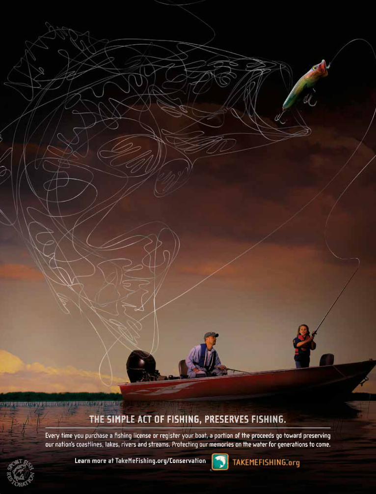
Every time you purchase a fi shing license or register your boat, a portion of the proceeds go toward preserving our nation’s coastlines, lakes, rivers and streams. Protecting our memories on the water for generations to come.
THE SIMPLE ACT OF FISHING, PRESERVES FISHING.
Learn more at TakeMeFishing.org/ConservationLearn more at TakeMeFishing.org/Conservation
46831_TMF_PSA_Pg_Ad.indd 1 2/4/11 9:53 AM

SELECTED SALTWATER FISH OF CALIFORNIA
Monkeyface prickleback(also known as monkeyface eel)
Lingcod Rock greenlingKelp greenling
Female Male
Pacific halibut California sheephead
Female Male
California halibut
High arch in lateral line
Large mouth w/ sharp teeth
White seabassKelp bass(also known as calico bass)
Spotted sand bassBarred sand bass
Redtail surfperch
High peak in dorsal fin
Barred surfperch Calico surfperch Striped surfperch
California scorpionfish(also known as sculpin)
Ocean whitefishCabezon
Does not possess scales
Roe poisonous
California corbina
Yellowtail
Giant sea bass(also known as black sea bass)
TAKE AND POSSESSION OF THESE SPECIES IS NOT ALLOWEDSee Section 28.10(b) for possession requirements for giant sea bass taken off Mexico
SEE SECTIONS 28.05 and 28.10 — BAG LIMIT: ZERO FISH
GaribaldiJuvenile giant seabass
Note to Anglers: The illustrations in this booklet do not show all color variations or characteristics for each type of fish. Anglers are ultimately responsible for identifying the fish they catch.
Illustrations are not to scale
40
2017–2018 CALIFORNIA SALTWATER FISHING REGULATIONS

SELECTED ROCKFISH OF CALIFORNIA
Treefish
Starry
Greenspotted
Rosy
Vermillion
Color varies from orange to deep red
Rough chin when rubbed back to front
Straight-edged tail fin
Gopher
Pinkish blotches
Black-and-yellow
Yellow blotches
Kelp
Brownish or greenish
mottling
Longer gill rakers
Grass
Black or gray mottling
Shorter gill rakers
Olive
Whitish blotches on back
Yellowtail
Light brown to gray mottling on side
Quillback
High, spiny dorsal fin
Brown
Dark brown spot
Copper
White band on lateral line
Bright white belly
China
Bright yellow strip
Bluish-white speckles
Chilipepper
Mouth extends to mid-eye
Blue
Mouth extends to mid-eye
Straight-edged anal fin
Bocaccio(also known as Salmon Grouper)
Mouth extends to rear of eye
Smooth chin
THESE SPECIES HAVE SUB-BAG LIMITS
Black
STATE WIDE BAG LIMIT: 1 FISH STATE WIDE BAG LIMIT: THREE FISH
Mouth extends past eye
Rounded anal fin
Black spots on dorsal fin
Canary
Lateral line clear/white
Slightly forked tail fin
TAKE AND POSSESSION OF THESE SPECIES IS NOT ALLOWED
SEE SECTIONS 28.55(b)(1) — BAG LIMIT: ZERO FISH
Yelloweye
Smooth chin
Raspy ridge above eye
Rolled tail fin edges
Cowcod
Deeply notched dorsal fin
Bronzespotted
Jaw upturned
Bronze spots on sides
(Rarely seen in recreational catch)
Juvenile yelloweye
41
2017–2018 CALIFORNIA SALTWATER FISHING REGULATIONS

CALIFORNIA’S MARINE PROTECTED AREAS
632. Marine Protected Areas (MPAs) Marine Managed Areas (MMAs) and Special Closures.(a) General Rules and Regulations: The areas
specified in this section have been declared by the commission to be marine protected areas (MPAs), marine managed areas (MMAs), or special closures. Public use of marine protect-ed areas, marine managed areas, or special closures shall be compatible with the primary purposes of such areas. MPAs, MMAs, and special closures are subject to the following general rules and regulations in addition to existing Fish and Game Code statutes and regulations of the commission, except as oth-erwise provided for in sub-section 632(b), ar-eas and special regulations for use. Nothing in this section expressly or implicitly precludes, restricts or requires modification of current or future uses of the waters identified as marine protected areas, special closures, or the lands or waters adjacent to these designated areas by the Department of Defense, its allies or agents.(1) Protection of Resources in MPAs and
MMAs, as defined in Public Resources Code Section 36710:(A) State Marine Reserves: In a state
marine reserve, it is unlawful to in-jure, damage, take, or possess any living, geological, or cultural marine resource, except under a scientific collecting permit issued by the de-partment pursuant to Section 650 or specific authorization from the com-mission for research, restoration, or monitoring purposes.
(B) State Marine Parks: In a state ma-rine park, it is unlawful to injure, damage, take, or possess any living or nonliving marine resource for commercial purposes. Any human use that would compromise protec-tion of the species of interest, natural community or habitat, or geological, cultural, or recreational features, may be restricted by the commission as specified in sub-section 632(b), areas and special regulations for use. The department may issue scientific col-lecting permits pursuant to Section 650. The commission may authorize research, monitoring, and education-al activities and certain recreational harvest in a manner consistent with protecting resource values.
(C) State Marine Conservation Areas: In a state marine conservation area, it is unlawful to injure, damage, take,
or possess any living, geological, or cultural marine resource for com-mercial or recreational purposes, or a combination of commercial and recreational purposes except as specified in sub-section 632(b), areas and special regulations for use. The department may issue scientif-ic collecting permits pursuant to Section 650. The commission may authorize research, education, and recreational activities, and certain commercial and recreational har-vest of marine resources, provided that these uses do not compromise protection of the species of interest, natural community, habitat, or geo-logical features.
(D) State Marine Recreational Man-agement Areas: In a state marine recreational management area, it is unlawful to perform any activity that would compromise the recreational values for which the area may be designated. Recreational opportu-nities may be protected, enhanced, or restricted, while preserving basic resource values of the area. No other use is restricted unless specified in sub-section 632(b), areas and special regulations for use.
(2) Finfish. Finfish, for the purpose of this section, are defined as any species of bony fish or cartilaginous fish (sharks, skates and rays). Finfish do not include amphib-ians, invertebrates, plants or algae. The definition of finfish provided in Section 159 does not apply to this Section.
(3) Pelagic Finfish. Pelagic finfish, for the purpose of this section, are a subset of finfish defined as: northern anchovy (En-graulis mordax), barracudas (Sphyraena spp.), billfishes* (family Istiophoridae), dolphinfish (Coryphaena hippurus), Pacific herring (Clupea pallasii), jack mackerel (Trachurus symmetricus), Pacific mackerel (Scomber japonicus), salmon (Oncorhynchus spp.), Pacific sardine (Sardinops sagax), blue shark (Prionace glauca), salmon shark (Lamna ditropis), shortfin mako shark (Isurus oxyrinchus), thresher sharks (Alopias spp.), swordfish (Xiphias gladius), tunas (family Scombridae) including Pacific bonito (Sarda chiliensis), and yellowtail (Seriola lalandi). *Marlin is not allowed for commercial take.
(4) Access. Access into marine protected areas or marine managed areas for non-con-sumptive uses including but not limited to swimming, surfing, diving, boating, hiking and walking is allowed unless oth-erwise specified in sub-section 632(b), areas and special regulations for use.
(5) Introduction of Species. Unless autho-rized by the commission or as a result of authorized fishing activities, the release of any fish or wildlife species, including domestic or domesticated species, or the introduction of any plant species, is prohibited. The department may rein-troduce endemic species to marine pro-tected areas or marine managed areas for management purposes.
(6) Feeding of Fish and Wildlife. The feeding of fish and wildlife is prohibited except permitted scientific collection pursuant to Section 650 or as a result of authorized fishing within state marine conserva-tion areas, state marine parks, and state marine recreational management areas, or unless feeding of fish is specifical-ly authorized in sub-section 632(b) for purposes of marine life viewing.
(7) Anchoring. Vessels shall be allowed to anchor in any marine protected area or marine managed area with catch onboard unless otherwise specified in sub-section 632(b), areas and special regulations for use. Fishing gear shall not be deployed in the water while anchored in a state marine reserve. Fishing gear, except legal fishing gear used to take species identified as allowed for take in sub-section 632(b), shall not be deployed in the water while anchored in a state marine recreational management area, state marine park or state marine conservation area. Anchoring regulations shall be consistent with federal law and allowances made for anchoring required by emergency or severe weather.
(8) Transit or Drifting. (A) Vessels shall be allowed to transit
through MPAs and MMAs with catch onboard. Fishing gear shall not be deployed in the water while transiting through a state marine reserve. Fishing gear, except legal fishing gear used to take species identified as allowed for take in sub-section 632(b), shall not be de-ployed in the water while transiting through a state marine recreational management area, state marine park or state marine conservation area.
(B) Spearfishermen with or without catch shall be allowed to transit through MPAs and MMAs. While transiting MPAs and MMAs that prohibit spearfishing or while in pos-session of species not identified as allowed for take in the MPA or MMA being transited, spearfishing gear
CALIFORNIA’S MARINE PROTECTED AREAS
42
2017–2018 CALIFORNIA SALTWATER FISHING REGULATIONS
CALIFORNIA’S MARINE PROTECTED AREAS
shall be in an unloaded condition, not carried in hand, and the diver shall remain at the surface.
(9) Water Quality Monitoring. Sampling of water, sediment and marine life, for water quality monitoring or pollution research, or as required in a Monitoring and Reporting Program of a National Pollutant Discharge Elimination Sys-tem (NPDES) Permit and Waste Dis-charge Requirements issued by the State or Regional Water Boards pursuant to the United States Clean Water Act and the California Water Code, is allowed within state marine reserves, state ma-rine conservation areas, state marine parks, and state marine recreational management areas pursuant to a valid scientific collecting permit issued by the department.
(10) Public Safety. Public safety activities, in-cluding installation, maintenance and/or seasonal placement and removal of safe-ty-related artificial structures, including but not limited to lifeguard towers, are allowed within any MPA classification pursuant to any required federal, state and local permits, or as otherwise au-thorized by the department.
(11) Tribal Take. For purposes of this regula-tion, “federally recognized tribe” means any tribe on the List of Indian Entities Recognized and Eligible to Receive Services from the United States Bureau of Indian Affairs, published annually in the Federal Register. Any member of a federally rec-ognized tribe authorized to take living marine resources from an area with ar-ea-specific take restrictions in sub-section 632(b), when engaging in take within an authorized area shall possess on his person, in his immediate possession, or where otherwise specifically required by law to be kept, any valid license, report card, tag, stamp, validation, permit, or any other entitlement that is required in the Fish and Game Code, or required by other state, federal, or local entities, in order to take living marine resourc-es. Members shall possess a valid photo identification card issued by a federally recognized tribe that contains expiration date, tribal name, tribal member number, name, signature, date of birth, height, color of eyes, color of hair, weight, and sex; and display any of the items listed above upon demand to any peace officer. Members taking living marine resources
under this provision are subject to current seasonal, bag, possession, gear and size limits in existing Fish and Game Code statutes and regulations of the commis-sion, except as otherwise provided for in sub-section 632(b). No member, while taking living marine resources pursuant to this section, may be assisted by any person who does not possess a valid tribal identification card and is not properly licensed to take living marine resources. Nothing in the regulation is intended to conflict with, or supersede, any state or federal law regarding the take of protect-ed, threatened or endangered species.
(12) Shore Fishing. Take from shore, or shore fishing, for purposes of this section, means take of living marine resources from shore, including beaches, banks, piers, jetties, breakwaters, docks, and other man-made structures connected to the shore. Unless specifically authorized in sub-section 632(b), no vessel, water-craft (motorized or non-motorized), or floating device may be used to assist in the take, transport or possession of spe-cies taken while shore fishing, except that a float tube or similar flotation device may be used when taking abalone only.
For advertising inquiries, please call
(413) 884-1001
Missed the printed edition?Ask about year-round digital opportunities.
Showcase your business in the CALIFORNIA
SALTWATERSPORT FISHING REGULATIONS
2017–2018
For Ocean Sport Fishing in CaliforniaEffective March 1, 2017 through February 28, 2018
SPORT FISHING REGULATIONSCALIFORNIA
SALTWATERSPORT FISHING REGULATIONS
43
2017–2018 CALIFORNIA SALTWATER FISHING REGULATIONS

CALIFORNIA’S MARINE PROTECTED AREAS
PROHIBITED AND PERMITTED RECREATIONAL TAKE, AND BOUNDARY COORDINATESNAME PERMITTED/PROHIBITED USES FOR RECREATIONAL TAKE BOUNDARY COORDINATES
Del Norte County
Pyramid Point State Marine Conservation Area
It is unlawful to injure, damage, take, or possess any living, geo-logical, or cultural marine resource for… recreational purposes, with the following specified exceptions:
1. The recreational take of surf smelt [Section 28.45] by dip net or Hawaiian-type throw net [Section 28.80] is allowed.
2. The following federally recognized tribe is exempt from the area and take regulations for Pyramid Point State Marine Conservation Area [sub-section 632(b)(1)] and shall comply with all other existing regulations and stat-utes: Tolowa Dee-ni’ Nation.
This area is bounded by the mean high tide line and straight lines connecting the following points in the order listed except where noted: 42° 00.000’ N. lat. 124° 12.735’ W. long.; 42° 00.000’ N. lat. 124° 19.814’ W. long.; thence southward along the three nautical mile offshore boundary to 41° 57.500’ N. lat. 124° 17.101’ W. long.; and 41° 57.500’ N. lat. 124° 12.423’ W. long.
Point St. George Reef Offshore State Marine Conservation Area
It is unlawful to injure, damage, take, or possess any living, geo-logical, or cultural marine resource for… recreational purposes, with the following specified exceptions:
1. The recreational take of salmon by trolling [sub-section 27.80(a)(3)]; and Dungeness crab by trap is allowed.
2. The following federally recognized tribes (listed alpha-betically) are exempt from the area and take regulations for Point St. George Reef Offshore State Marine Con-servation Area [subsection 632(b)(2))] and shall comply with all other existing regulations and statutes: Elk Valley Rancheria and Tolowa Dee-ni’ Nation.
This area is bounded by straight lines connecting the fol-lowing points in the order listed except where noted: 41° 52.000’ N. lat. 124° 23.189’ W. long.; 41° 52.000’ N. lat. 124° 25.805’ W. long.; thence south-ward along the three nautical mile offshore boundary to 41° 49.000’ N. lat. 124° 26.252’ W. long.; 41° 49.000’ N. lat. 124° 23.189’ W. long.; and 41° 52.000’ N. lat. 124° 23.189’ W. long.
Southwest Seal Rock Special Closure
Special restrictions on boating and access apply to Southwest Seal Rock as follows.
(A) A special closure is designated from the mean high tide line to a distance of 300 feet seaward of the mean lower low tide line of any shoreline of Southwest Seal Rock, located in the vicinity of 41° 48.810’ N. lat. 124° 21.099’ W. long.
(B) Except as permitted by federal law or emergency caused by hazardous weather, or as authorized by sub-section …(C), no vessel shall be operated or anchored at any time from the mean high tide line to a distance of 300 feet seaward of the mean lower low tide line of any shoreline of Southwest Seal Rock.
(C) No person except department employees or employees of the United States Fish and Wildlife Service, National Oceanic and Atmospheric Administration, or United States Coast Guard, in performing their official duties, or unless permission is granted by the department, shall enter the area defined in sub-section …(B).
Castle Rock Special Closure
Special restrictions on boating and access apply to Castle Rock as follows.
(A) A special closure is designated from the mean high tide line to a distance of 300 feet seaward of the mean lower low tide line of any shoreline of Castle Rock, located in the vicinity of 41° 45.706’ N. lat. 124° 14.949’ W. long.
(B) Except as permitted by federal law or emergency caused by hazardous weather, or as authorized by sub-section …(C), no vessel shall be operated or anchored at any time from the mean high tide line to a distance of 300 feet seaward of the mean lower low tide line of any shoreline of Castle Rock.
(C) No person except department employees or employees of the United States Fish and Wildlife Service, National Oceanic and Atmospheric Administration, or United States Coast Guard, in performing their official duties, or unless permission is granted by the department, shall enter the area defined in sub-section 632(b)(4)(B).
CALIFORNIA’S MARINE PROTECTED AREASThere are numerous areas along the California coast that have regulations more restrictive than the general fishing regulations.
These areas, known as marine protected areas (MPAs) are designated in part to protect, conserve, or enhance marine life. The following table lists all existing MPAs in ocean and estuarine waters that regulate sport fishing, species permitted or prohibited for take, and detailed boundary descriptions. Only regulations that pertain to sport fishing are included here. For further information, please contact the CDFW’s Marine Region in Eureka at (707) 445-6493, Monterey at (831) 649-2870 or Los Alamitos at (562) 342-7100, or email [email protected].
Note: The following regulations are from CCR T-14, Section 632(b). Within each county, the areas are arranged generally from north to south. Special closures and marine managed areas are also included in this table. While technically they do not meet the definition of a marine protected area, their restrictions differ significantly from the surrounding areas, so they are included here for ease of identification by the public. For more information please see the CDFW website at wildlife.ca.gov/MPAs.
44

CALIFORNIA’S MARINE PROTECTED AREAS
PROHIBITED AND PERMITTED RECREATIONAL TAKE, AND BOUNDARY COORDINATES (CONT.)NAME PERMITTED/PROHIBITED USES FOR RECREATIONAL TAKE BOUNDARY COORDINATES
False Klamath Rock Special Closure
Special restrictions on boating and access apply to False Klamath Rock as follows.
(A) A special closure is designated from the mean high tide line to a distance of 300 feet seaward of the mean lower low tide line of any shoreline of False Klamath Rock, located in the vicinity of 41° 35.633’ N. lat. 124° 06.699’ W. long. during the period of March 1 to August 31.
(B) Except as permitted by federal law or emergency caused by hazardous weather, or as authorized by subsection …(C), no vessel shall be operated or anchored from the mean high tide line to a distance of 300 feet seaward of the mean lower low tide line of any shoreline of False Klamath Rock during the period of March 1 to August 31.
(C) No person except department employees or employees of the United States Fish and Wildlife Service, National Oceanic and Atmospheric Administration, or United States Coast Guard, in performing their official duties, or unless permission is granted by the department, shall enter the area defined in subsection …(B) during the period of March 1 to August 31.
Humboldt County
Reading Rock State Marine Conservation Area
It is unlawful to injure, damage, take, or possess any living, geo-logical, or cultural marine resource for… recreational purposes, with the following specified exceptions:
1. The recreational take of salmon by trolling [subsection 27.80(a)(3)]; surf smelt [Section 28.45] by dip net or Hawaiian-type throw net [Section 28.80]; and Dunge-ness crab by trap, hoop net or hand is allowed.
2. The following federally recognized tribes are exempt from the area and take regulations for Reading Rock State Marine Conservation Area [subsection 632(b)(6)] and shall comply with all other existing regulations and statutes: Cher-Ae Heights Indian Community of the Trin-idad Rancheria, Resighini Rancheria, and Yurok Tribe of the Yurok Reservation.
This area is bounded by the mean high tide line and straight lines connecting the following points in the order listed: 41° 20.100’ N. lat. 124° 04.911’ W. long.; 41° 20.100’ N. lat. 124° 10.000’ W. long.; 41° 17.600’ N. lat. 124° 10.000’ W. long.; and 41° 17.600’ N. lat. 124° 05.399’ W. long.
Reading Rock State Marine Reserve
It is unlawful to injure, damage, take, or possess any living, geo-logical, or cultural marine resource for… recreational purposes.
This area is bounded by straight lines connecting the fol-lowing points in the order listed except where noted: 41° 20.100’ N. lat. 124° 10.000’ W. long.; 41° 20.100’ N. lat. 124° 14.655’ W. long.; thence southward along the three nautical mile offshore boundary to 41° 17.600’ N. lat. 124° 11.963’ W. long.; 41° 17.600’ N. lat. 124° 10.000’ W. long.; and 41° 20.100’ N. lat. 124° 10.000’ W. long.
Samoa State Marine Conservation Area
It is unlawful to injure, damage, take, or possess any living, geo-logical, or cultural marine resource for… recreational purposes, with the following specified exceptions:
1. The recreational take of salmon by trolling [subsec-tion 27.80(a)(3)]; surf smelt [Section 28.45] by dip net or Hawaiian-type throw net [Section 28.80]; and Dungeness crab by trap, hoop net or hand is allowed.
2. The following federally recognized tribe is exempt from the area and take regulations for Samoa State Marine Conser-vation Area [subsection 632(b)(8)] and shall comply with all other existing regulations and statutes: Wiyot Tribe.
This area is bounded by the mean high tide line and straight lines connecting the following points in the order listed except where noted: 40° 55.000’ N. lat. 124° 08.432’ W. long.; 40° 55.000’ N. lat. 124° 12.677’ W. long.; thence southward along the three nautical mile offshore boundary to 40° 52.000’ N. lat. 124° 14.225’ W. long.; and 40° 52.000’ N. lat. 124° 09.803’ W. long.
SPORT FISHING SPECIAL ALERT FOR CALIFORNIA SALMON FISHERIES
The California coast coho (silver) salmon has been designated as an endangered species under the federal Endangered Species Act (ESA). It is unlawful to fish for, capture, keep, or possess under any circumstances any (marked or unmarked) coho salmon. Violation of the ESA may result in civil or criminal penalties.
Large numbers of coho salmon have been contacted in California’s ocean waters. Although it is likely that many of these salmon originated from hatcheries in the Northwest, some of the fish are California coast coho salmon which are protected under the ESA. Thus, the retention of any coho salmon is PROHIBITED in all California ocean fisheries. Please take the time to correctly identify each salmon caught before removing it from the water.
To avoid contact with Coho salmon:• Fish near shore for Chinook – coho are usually more offshore.• Use larger lures that select for large Chinook and reduce the coho catch.
Coho (silver) salmon, above right, have white gums around the teeth, while the inside of a Chinook (king) salmon’s mouth is all dark.
Pho
to b
y C
DFW
War
den
Bob
Ald
rich
45

CALIFORNIA’S MARINE PROTECTED AREAS
PROHIBITED AND PERMITTED RECREATIONAL TAKE, AND BOUNDARY COORDINATES (CONT.)NAME PERMITTED/PROHIBITED USES FOR RECREATIONAL TAKE BOUNDARY COORDINATES
South Humboldt Bay State Marine Recreational Management Area
It is unlawful to perform any activity that would compromise the recreational values for which the area may be designated. Recre-ational opportunities may be protected, enhanced, or restricted, while preserving basic resource values of the area,
1. The following federally recognized tribe is exempt from the area and take regulations for South Humboldt Bay State Marine Recreational Management Area [subsection 632(b)(9)] and shall comply with all other existing regula-tions and statutes: Wiyot Tribe.
2. Waterfowl may be taken in accordance with the general waterfowl regulations [sections 502, 550, 551, and 552].
This area is bounded by the mean high tide line and straight lines connecting the following points in the order listed: 40° 43.000’ N. lat. 124° 15.527’ W. long.; 40° 43.000’ N. lat. 124° 15.000’ W. long.; 40° 42.000’ N. lat. 124° 15.000’ W. long.; and 40° 42.000’ N. lat. 124° 16.141’ W. long.
Sugarloaf Island Special Closure
Special restrictions on boating and access apply to Sugarloaf Island as follows.
(A) A special closure is designated from the mean high tide line to a distance of 300 feet seaward of the mean lower low tide line of any shoreline of Sugarloaf Island, located in the vicinity of 40° 26.326’ N. lat. 124° 24.827’ W. long.
(B) Except as permitted by federal law or emergency caused by hazardous weather, or as authorized by subsection…(C), no vessel shall be operated or anchored at any time from the mean high tide line to a distance of 300 feet seaward of the mean lower low tide line of any shoreline of Sugarloaf Island.
(C) No person except department employees or employees of the United States Fish and Wildlife Service, National Oceanic and Atmospheric Administration, or United States Coast Guard, in performing their official duties, or unless permission is granted by the department, shall enter the area defined in subsection …(B).
South Cape Mendocino State Marine Reserve
It is unlawful to injure, damage, take, or possess any living, geo-logical, or cultural marine resource for… recreational purposes.
This area is bounded by the mean high tide line and straight lines connecting the following points in the order listed except where noted: 40° 26.100’ N. lat. 124° 24.340’ W. long.; 40° 26.100’ N. lat. 124° 31.958’ W. long.; thence southward along the three nautical mile offshore boundary to 40° 24.900’ N. lat. 124° 31.084’ W. long.; and 40° 24.900’ N. lat. 124° 23.800’ W. long.
Steamboat Rock Special Closure
Special restrictions on boating and access apply to Steamboat Rock as follows.
(A) A special closure is designated from the mean high tide line to a distance of 300 feet seaward of the mean lower low tide line of any shoreline of Steamboat Rock, located in the vicinity of 40° 24.919’ N. lat. 124° 24.241’ W. long. during the period of March 1 to August 31.
(B) Except as permitted by federal law or emergency caused by hazardous weather, or as authorized by subsection…(C), no vessel shall be operated or anchored from the mean high tide line to a distance of 300 feet seaward of the mean lower low tide line of any shoreline of Steamboat Rock during the period of March 1 to August 31.
(C) No person except department employees or employees of the United States Fish and Wildlife Service, National Oceanic and Atmospheric Administration, or United States Coast Guard, in performing their official duties, or unless permission is granted by the department, shall enter the area defined in subsection …(B) during the period of March 1 to August 31.
Mattole Canyon State Marine Reserve
It is unlawful to injure, damage, take, or possess any living, geo-logical, or cultural marine resource for… recreational purposes.
This area is bounded by straight lines connecting the fol-lowing points in the order listed except where noted: 40° 20.000’ N. lat. 124° 22.500’ W. long.; 40° 20.000’ N. lat. 124° 25.902’ W. long.; thence south-ward along the three nautical mile offshore boundary to 40° 17.000’ N. lat. 124° 25.869’ W. long.; 40° 17.000’ N. lat. 124° 22.500’ W. long.; and 40° 20.000’ N. lat. 124° 22.500’ W. long.
Sea Lion Gulch State Marine Reserve
It is unlawful to injure, damage, take, or possess any living, geo-logical, or cultural marine resource for… recreational purposes.
This area is bounded by the mean high tide line and straight lines connecting the following points in the order listed except where noted: 40° 14.400’ N. lat. 124° 19.983’ W. long.; 40° 14.400’ N. lat. 124° 25.943’ W. long.; thence south-ward along the three nautical mile offshore boundary to 40° 12.800’ N. lat. 124° 24.809’ W. long.; and 40° 12.800’ N. lat. 124° 18.155’ W. long.
Big Flat State Marine Conservation Area
It is unlawful to injure, damage, take, or possess any living, geo-logical, or cultural marine resource for… recreational purposes, with the following specified exceptions:
1. The recreational take of salmon by trolling [subsection 27.80(a)(3)]; and Dungeness crab by trap, hoop net or hand is allowed.
2. The following federally recognized tribes (listed alpha-betically) are exempt from the area and take regulations for Big Flat State Marine Conservation Area [subsection 632(b)(15)] and shall comply with all other existing regu-lations and statutes: SEE FOOTNOTE 1
This area is bounded by the mean high tide line and straight lines connecting the following points in the order listed except where noted: 40° 09.400’ N. lat. 124° 12.671’ W. long.; 40° 09.400’ N. lat. 124° 19.366’ W. long.; thence south-ward along the three nautical mile offshore boundary to 40° 07.500’ N. lat. 124° 16.203’ W. long.; and 40° 07.500’ N. lat. 124° 10.313’ W. long.
46

CALIFORNIA’S MARINE PROTECTED AREAS
PROHIBITED AND PERMITTED RECREATIONAL TAKE, AND BOUNDARY COORDINATES (CONT.)NAME PERMITTED/PROHIBITED USES FOR RECREATIONAL TAKE BOUNDARY COORDINATES
Mendocino County
Double Cone Rock State Marine Conservation Area
It is unlawful to injure, damage, take, or possess any living, geo-logical, or cultural marine resource for… recreational purposes, with the following specified exceptions:
1. The recreational take of salmon by trolling [subsection 27.80(a)(3); and Dungeness crab by trap, hoop net or hand is allowed.
2. The following federally recognized tribes (listed alpha-betically) are exempt from the area and take regulations for Double Cone Rock State Marine Conservation Area [subsection 632(b)(16)] and shall comply with all other existing regulations and statutes: SEE FOOTNOTE 2
This area is bounded by the mean high tide line and straight lines connecting the following points in the order listed except where noted: 39° 48.500’ N. lat. 123° 50.713’ W. long.; 39° 48.500’ N. lat. 123° 55.875’ W. long.; thence south-ward along the three nautical mile offshore boundary to 39° 44.300’ N. lat. 123° 54.178’ W. long.; and 39° 44.300’ N. lat. 123° 50.055’ W. long.
Rockport Rocks Special Closure
Special restrictions on boating and access apply to Rockport Rocks as follows.
(A) A special closure is designated from the mean high tide line to a distance of 300 feet seaward of the mean lower low tide line of any shoreline of Rockport Rocks, located in the vicinity of 39° 44.184’ N. lat. 123° 50.020’ W. long. during the period of March 1 to August 31.
(B) Except as permitted by federal law or emergency caused by hazardous weather, or as authorized by subsection …(C), no vessel shall be operated or anchored from the mean high tide line to a distance of 300 feet seaward of the mean lower low tide line of any shoreline of Rockport Rocks during the period of March 1 to August 31.
(C) No person except department employees or employees of the United States Fish and Wildlife Service, National Oceanic and Atmospheric Administration, or United States Coast Guard, in performing their official duties, or unless permission is granted by the department, shall enter the area defined in subsection …(B) during the period of March 1 to August 31.
Vizcaino Rock Special Closure
Special restrictions on boating and access apply to Vizcaino Rock located in the vicinity of 39° 43.618’ N. lat. 123° 49.950’ W. long. as follows.
(A) A special closure is designated from the mean high tide line to a distance of 300 feet seaward of the mean lower low tide of any shoreline of Vizcaino Rock westward of 123°49.887’ W. longitude, during the period of March 1 to August 31.
(B) Except as permitted by federal law or emergency caused by hazardous weather, or as authorized by subsection …(C), no vessel shall be operated or anchored from the mean high tide line to a distance of 300 feet seaward of the mean lower low tide line of any shoreline of Vizcaino Rock westward of 123° 49.887’ W. longitude during the period of March 1 to August 31.
(C) No person except department employees or employees of the United States Fish and Wildlife Service, National Oceanic and Atmospheric Administration, or United States Coast Guard, in performing their official duties, or unless permission is granted by the department, shall enter the area defined in subsection …(B) during the period of March 1 to August 31.
Ten Mile State Marine Reserve
It is unlawful to injure, damage, take, or possess any living, geo-logical, or cultural marine resource for… recreational purposes.
This area is bounded by the mean high tide line and straight lines connecting the following points in the order listed except where noted: 39° 35.900’ N. lat. 123° 47.243’ W. long.; 39° 35.900’ N. lat. 123° 51.479’ W. long.; thence south-ward along the three nautical mile offshore boundary to 39° 33.300’ N. lat. 123° 50.559’ W. long.; and 39° 33.300’ N. lat. 123° 46.015’ W. long.
Ten Mile Beach State Marine Conservation Area
It is unlawful to injure, damage, take, or possess any living, geo-logical, or cultural marine resource for… recreational purposes, with the following specified exceptions:
1. The recreational take of Dungeness crab by trap, hoop net or hand is allowed.
2. The following federally recognized tribes (listed alpha-betically) are exempt from the area and take regulations for Ten Mile Beach State Marine Conservation Area [subsection 632(b)(20)] and shall comply with all other existing regulations and statutes: SEE FOOTNOTE 2
This area is bounded by the mean high tide line and straight lines connecting the following points in the order listed except where noted: 39° 33.300’ N. lat. 123° 46.015’ W. long.; 39° 33.300’ N. lat. 123° 50.559’ W. long.; thence south-ward along the three nautical mile offshore boundary to 39° 32.500’ N. lat. 123° 50.418’ W. long.; and 39° 32.500’ N. lat. 123° 46.242’ W. long.; thence north-ward along the mean high tide line onshore boundary to 39° 33.098’ N. lat. 123° 46.003’ W. long.; and 39° 33.199’ N. lat. 123° 45.966’ W. long.
Ten Mile Estuary State Marine Conservation Area3
It is unlawful to injure, damage, take, or possess any living, geo-logical, or cultural marine resource for… recreational purposes, with the following specified exceptions:
1. The following federally recognized tribes (listed alpha-betically) are exempt from the area and take regulations for Ten Mile Estuary State Marine Conservation Area [subsection 632(b)(21)] and shall comply with all other existing regulations and statutes: SEE FOOTNOTE 2
2. Waterfowl may be taken in accordance with the general waterfowl regulations [sections 502, 550, 551, and 552].
This area consists of waters below the mean high tide line within the Ten Mile Estuary, eastward of a line connecting the following two points: 39° 33.199’ N. lat. 123° 45.966’ W. long.; and 39° 33.098’ N. lat. 123° 46.003’ W. long. and westward of a line connecting the following two points: 39° 32.400’ N. lat. 123° 44.785’ W. long.; and 39° 32.382’ N. lat. 123° 44.769’ W. long.
47

CALIFORNIA’S MARINE PROTECTED AREAS
PROHIBITED AND PERMITTED RECREATIONAL TAKE, AND BOUNDARY COORDINATES (CONT.)NAME PERMITTED/PROHIBITED USES FOR RECREATIONAL TAKE BOUNDARY COORDINATES
MacKerricher State Marine Conservation Area
It is unlawful to injure, damage, take, or possess any living, geo-logical, or cultural marine resource for… recreational purposes, with the following specified exceptions:
1. All recreational take is allowed in accordance with cur-rent regulations.
This area is bounded by the mean high tide line and straight lines connecting the following points in the order listed: 39° 30.100’ N. lat. 123° 47.327’ W. long.; 39° 30.100’ N. lat. 123° 49.000’ W. long.; 39° 27.120’ N. lat. 123° 49.000’ W. long.; and 39° 27.120’ N. lat. 123° 48.830’ W. long.
Point Cabrillo State Marine Reserve
It is unlawful to injure, damage, take, or possess any living, geo-logical, or cultural marine resource for… recreational purposes
This area is bounded by the mean high tide line and straight lines connecting the following points in the order listed: 39° 21.400’ N. lat. 123° 49.418’ W. long.; 39° 21.400’ N. lat. 123° 50.000’ W. long.; 39° 20.600’ N. lat. 123° 50.000’ W. long.; and 39° 20.600’ N. lat. 123° 49.266’ W. long.
Russian Gulch State Marine Conservation Area
It is unlawful to injure, damage, take, or possess any living, geo-logical, or cultural marine resource for… recreational purposes, with the following specified exceptions:
1. All recreational take is allowed in accordance with cur-rent regulations.
This area is bounded by the mean high tide line and straight lines connecting the following points in the order listed: 39° 19.860’ N. lat. 123° 48.840’ W. long.; 39° 19.860’ N. lat. 123° 49.000’ W. long.; 39° 19.470’ N. lat. 123° 49.000’ W. long.; and 39° 19.470’ N. lat. 123° 48.500’ W. long.
Big River Estuary State Marine Conservation Area3
It is unlawful to injure, damage, take, or possess any living, geo-logical, or cultural marine resource for… recreational purposes, with the following specified exceptions:
1. The recreational take of surfperch (family Embiotocidae) by hook-and-line from shore only; and Dungeness crab by hoop net or hand is allowed.
2. The following federally recognized tribes (listed alpha-betically) are exempt from the area and take regulations for Big River Estuary State Marine Conservation Area [subsection 632(b)(25)] and shall comply with all other existing regulations and statutes: SEE FOOTNOTE 2
3. Waterfowl may be taken in accordance with the general waterfowl regulations [sections 502, 550, 551, and 552].
This area consists of waters below the mean high tide line within the Big River Estuary, eastward of a line connecting the following two points: 39° 18.134’ N. lat. 123° 47.517’ W. long.; and 39° 18.070’ N. lat. 123° 47.543’ W. long. and westward of a line connecting the following two points: 39° 18.222’ N. lat. 123° 46.242’ W. long.; and 39° 18.150’ N. lat. 123° 46.240’ W. long.
Van Damme State Marine Conservation Area
It is unlawful to injure, damage, take, or possess any living, geo-logical, or cultural marine resource for… recreational purposes, with the following specified exceptions:
1. All recreational take is allowed in accordance with cur-rent regulations.
This area is bounded by the mean high tide line and a straight line connecting the following points: 39° 16.335’ N. lat. 123° 47.712’ W. long.; and 39° 16.147’ N. lat. 123° 47.429’ W. long.
Navarro River Estuary State Marine Conservation Area
It is unlawful to injure, damage, take, or possess any living, geo-logical, or cultural marine resource for… recreational purposes, with the following specified exceptions:
1. The recreational take of salmonids by hook-and-line is allowed consistent with salmonid regulations in Section 7.50.
2. The following federally recognized tribes (listed alphabet-ically) are exempt from the area and take regulations for Navarro River Estuary State Marine Conservation Area [subsection 632(b)(27)] and shall comply with all other existing regulations and statutes: SEE FOOTNOTE 2
3. Waterfowl may be taken in accordance with the general waterfowl regulations [sections 502, 550, 551, and 552].
This area consists of waters below the mean high tide line within the Navarro River Estuary, eastward of a line con-necting the following two points: 39° 11.536’ N. lat. 123° 45.685’ W. long.; and 39° 11.489’ N. lat. 123° 45.516’ W. long. and westward of a line connecting the following two points 39° 11.846’ N. lat. 123° 44.809’ W. long.; and 39° 11.803’ N. lat. 123° 44.843’ W. long.
Point Arena State Marine Reserve
It is unlawful to injure, damage, take, or possess any living, geo-logical, or cultural marine resource for… recreational purposes.
This area is bounded by the mean high tide line and straight lines connecting the following points in the order listed: 38° 57.350’ N. lat. 123° 44.500’ W. long.; 38° 59.000’ N. lat. 123° 44.500’ W. long.; 38° 59.000’ N. lat. 123° 46.000’ W. long.; 38° 56.400’ N. lat. 123° 46.000’ W. long.; and 38° 56.400’ N. lat. 123° 43.820’ W. long.
Point Arena State Marine Conservation Area
It is unlawful to injure, damage, take, or possess any living, geo-logical, or cultural marine resource for… recreational purposes, with the following specified exceptions
1. The recreational take of salmon by trolling [subsection 27.80(a)(3)] is allowed.
This area is bounded by straight lines connecting the fol-lowing points in the order listed except where noted: 38° 59.000’ N. lat. 123° 46.000’ W. long.; 38° 59.000’ N. lat. 123° 48.162’ W. long.; thence south-ward along the three nautical mile offshore boundary to 38° 56.400’ N. lat. 123° 48.350’ W. long.; 38° 56.400’ N. lat. 123° 46.000’ W. long.; and 38° 59.000’ N. lat. 123° 46.000’ W. long.
48
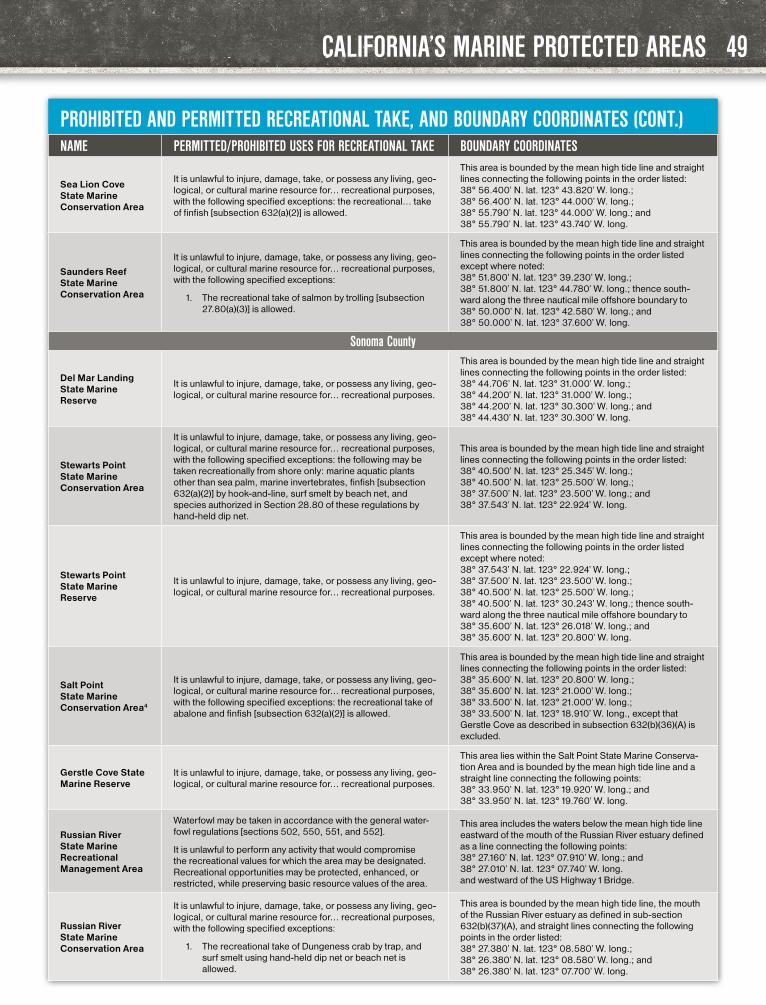
CALIFORNIA’S MARINE PROTECTED AREAS
PROHIBITED AND PERMITTED RECREATIONAL TAKE, AND BOUNDARY COORDINATES (CONT.)NAME PERMITTED/PROHIBITED USES FOR RECREATIONAL TAKE BOUNDARY COORDINATES
Sea Lion Cove State Marine Conservation Area
It is unlawful to injure, damage, take, or possess any living, geo-logical, or cultural marine resource for… recreational purposes, with the following specified exceptions: the recreational… take of finfish [subsection 632(a)(2)] is allowed.
This area is bounded by the mean high tide line and straight lines connecting the following points in the order listed: 38° 56.400’ N. lat. 123° 43.820’ W. long.; 38° 56.400’ N. lat. 123° 44.000’ W. long.; 38° 55.790’ N. lat. 123° 44.000’ W. long.; and 38° 55.790’ N. lat. 123° 43.740’ W. long.
Saunders Reef State Marine Conservation Area
It is unlawful to injure, damage, take, or possess any living, geo-logical, or cultural marine resource for… recreational purposes, with the following specified exceptions:
1. The recreational take of salmon by trolling [subsection 27.80(a)(3)] is allowed.
This area is bounded by the mean high tide line and straight lines connecting the following points in the order listed except where noted: 38° 51.800’ N. lat. 123° 39.230’ W. long.; 38° 51.800’ N. lat. 123° 44.780’ W. long.; thence south-ward along the three nautical mile offshore boundary to 38° 50.000’ N. lat. 123° 42.580’ W. long.; and 38° 50.000’ N. lat. 123° 37.600’ W. long.
Sonoma County
Del Mar Landing State Marine Reserve
It is unlawful to injure, damage, take, or possess any living, geo-logical, or cultural marine resource for… recreational purposes.
This area is bounded by the mean high tide line and straight lines connecting the following points in the order listed: 38° 44.706’ N. lat. 123° 31.000’ W. long.; 38° 44.200’ N. lat. 123° 31.000’ W. long.; 38° 44.200’ N. lat. 123° 30.300’ W. long.; and 38° 44.430’ N. lat. 123° 30.300’ W. long.
Stewarts Point State Marine Conservation Area
It is unlawful to injure, damage, take, or possess any living, geo-logical, or cultural marine resource for… recreational purposes, with the following specified exceptions: the following may be taken recreationally from shore only: marine aquatic plants other than sea palm, marine invertebrates, finfish [subsection 632(a)(2)] by hook-and-line, surf smelt by beach net, and species authorized in Section 28.80 of these regulations by hand-held dip net.
This area is bounded by the mean high tide line and straight lines connecting the following points in the order listed: 38° 40.500’ N. lat. 123° 25.345’ W. long.; 38° 40.500’ N. lat. 123° 25.500’ W. long.; 38° 37.500’ N. lat. 123° 23.500’ W. long.; and 38° 37.543’ N. lat. 123° 22.924’ W. long.
Stewarts Point State Marine Reserve
It is unlawful to injure, damage, take, or possess any living, geo-logical, or cultural marine resource for… recreational purposes.
This area is bounded by the mean high tide line and straight lines connecting the following points in the order listed except where noted: 38° 37.543’ N. lat. 123° 22.924’ W. long.; 38° 37.500’ N. lat. 123° 23.500’ W. long.; 38° 40.500’ N. lat. 123° 25.500’ W. long.; 38° 40.500’ N. lat. 123° 30.243’ W. long.; thence south-ward along the three nautical mile offshore boundary to 38° 35.600’ N. lat. 123° 26.018’ W. long.; and 38° 35.600’ N. lat. 123° 20.800’ W. long.
Salt Point State Marine Conservation Area4
It is unlawful to injure, damage, take, or possess any living, geo-logical, or cultural marine resource for… recreational purposes, with the following specified exceptions: the recreational take of abalone and finfish [subsection 632(a)(2)] is allowed.
This area is bounded by the mean high tide line and straight lines connecting the following points in the order listed: 38° 35.600’ N. lat. 123° 20.800’ W. long.; 38° 35.600’ N. lat. 123° 21.000’ W. long.; 38° 33.500’ N. lat. 123° 21.000’ W. long.; 38° 33.500’ N. lat. 123° 18.910’ W. long., except that Gerstle Cove as described in subsection 632(b)(36)(A) is excluded.
Gerstle Cove State Marine Reserve
It is unlawful to injure, damage, take, or possess any living, geo-logical, or cultural marine resource for… recreational purposes.
This area lies within the Salt Point State Marine Conserva-tion Area and is bounded by the mean high tide line and a straight line connecting the following points: 38° 33.950’ N. lat. 123° 19.920’ W. long.; and 38° 33.950’ N. lat. 123° 19.760’ W. long.
Russian River State Marine Recreational Management Area
Waterfowl may be taken in accordance with the general water-fowl regulations [sections 502, 550, 551, and 552].
It is unlawful to perform any activity that would compromise the recreational values for which the area may be designated. Recreational opportunities may be protected, enhanced, or restricted, while preserving basic resource values of the area.
This area includes the waters below the mean high tide line eastward of the mouth of the Russian River estuary defined as a line connecting the following points: 38° 27.160’ N. lat. 123° 07.910’ W. long.; and 38° 27.010’ N. lat. 123° 07.740’ W. long. and westward of the US Highway 1 Bridge.
Russian River State Marine Conservation Area
It is unlawful to injure, damage, take, or possess any living, geo-logical, or cultural marine resource for… recreational purposes, with the following specified exceptions:
1. The recreational take of Dungeness crab by trap, and surf smelt using hand-held dip net or beach net is allowed.
This area is bounded by the mean high tide line, the mouth of the Russian River estuary as defined in sub-section 632(b)(37)(A), and straight lines connecting the following points in the order listed: 38° 27.380’ N. lat. 123° 08.580’ W. long.; 38° 26.380’ N. lat. 123° 08.580’ W. long.; and 38° 26.380’ N. lat. 123° 07.700’ W. long.
49

CALIFORNIA’S MARINE PROTECTED AREAS
PROHIBITED AND PERMITTED RECREATIONAL TAKE, AND BOUNDARY COORDINATES (CONT.)NAME PERMITTED/PROHIBITED USES FOR RECREATIONAL TAKE BOUNDARY COORDINATES
Bodega Head State Marine Reserve
It is unlawful to injure, damage, take, or possess any living, geo-logical, or cultural marine resource for… recreational purposes, with specified exceptions for scientific research. Additionally, within the Bodega Marine Life Refuge (a small nearshore area within Bodega Head SMR): No anchoring except as permit-ted by federal law, or during hazardous weather. CDFW and the Bodega Marine Life Refuge director may permit access, anchoring, and take for scientific or educational purposes. See Section 632(a)(39)
This area is bounded by the mean high tide line and straight lines connecting the following points in the order listed except where noted: 38° 20.100’ N. lat. 123° 04.123’ W. long.; 38° 20.100’ N. lat. 123° 08.448’ W. long.; thence south-ward along the three nautical mile offshore boundary to 38° 18.000’ N. lat. 123° 08.140’ W. long.; and 38° 18.000’ N. lat. 123° 03.680’ W. long.
Bodega Head State Marine Conservation Area
It is unlawful to injure, damage, take, or possess any living, geo-logical, or cultural marine resource for… recreational purposes, with the following specified exceptions:
1. The recreational take of pelagic finfish5 [subsection 632(a)(3)] by trolling [subsection 27.80(a)(3)], Dunge-ness crab by trap, and market squid by hand-held dip net, is allowed.
This area is bounded by the mean high tide line and straight lines connecting the following points in the order listed except where noted: 38° 18.00’ N. lat. 123° 03.680’ W. long.; 38° 18.00’ N. lat. 123° 08.140’ W. long.; thence southward along the three nautical mile offshore boundary to 38° 13.340’ N. lat. 123° 03.510’ W. long.; and 38° 17.930’ N. lat. 123° 03.510’ W. long.
Estero Americano State Marine Recreational Management Area
Waterfowl may be taken in accordance with the general waterfowl regulations [sections 502, 550, 551, and 552]. It is unlawful to perform any activity that would compromise the recreational values for which the area may be designated. Recreational opportunities may be protected, enhanced, or restricted, while preserving basic resource values of the area.
This area includes the waters below the mean high tide line within Estero Americano westward of longitude 122° 59.250’ W.
Napa County
Fagan Marsh State Marine Park (estuarine)
Any human use that would compromise protection of the species of interest, natural community or habitat, or geological, cultural, or recreational features, may be restricted, with the following specified exceptions: the recreational hook-and-line take of spe-cies other than marine aquatic plants is allowed. Only lightweight, hand-carried boats may be launched or operated within the park. Other restrictions apply. See subsection 632(a)(1)(B) on pg. 42
This area consists of waters below the mean high tide line within the Fagan Marsh Ecological Reserve.
Marin County
Estero de San Antonio State Marine Recreational Management Area
Waterfowl may be taken in accordance with the general waterfowl regulations [sections 502, 550, 551, and 552]. It is unlawful to perform any activity that would compromise the recreational values for which the area may be designated. Recreational opportunities may be protected, enhanced, or restricted, while preserving basic resource values of the area.
This area includes the waters below the mean high tide line within Estero de San Antonio westward of longitude 122° 57.400’ W.
Point Reyes State Marine Reserve
It is unlawful to injure, damage, take, or possess any living, geo-logical, or cultural marine resource for… recreational purposes.
This area is bounded by the mean high tide line and straight lines connecting the following points in the order listed: 37° 59.900’ N. lat. 123° 01.278’ W. long.; 37° 59.900’ N. lat. 123° 02.000’ W. long.; 37° 59.000’ N. lat. 123° 02.000’ W. long.; 37° 59.000’ N. lat. 122° 57.340’ W. long.; and 38° 01.750’ N. lat. 122° 55.000’ W. long.; thence westward along the mean high tide line onshore boundary to 38° 01.783’ N. lat. 122° 55.286’ W. long.; and 38° 01.941’ N. lat. 122° 56.364’ W. long.
Point Reyes State Marine Conservation Area
It is unlawful to injure, damage, take, or possess any living, geo-logical, or cultural marine resource for… recreational purposes, with the following specified exceptions:
1. The recreational take of salmon by trolling [subsection 27.80(a)(3)] and Dungeness crab by trap is allowed.
This area is bounded by straight lines connecting the fol-lowing points in the order listed except where noted: 37° 59.000’ N. lat. 123° 02.000’ W. long.; 37° 56.712’ N. lat. 123° 02.000’ W. long.; thence eastward along the three nautical mile offshore boundary to 37° 56.370’ N. lat. 122° 57.340’ W. long.; 37° 59.000’ N. lat. 122° 57.340’ W. long.; and 37° 59.000’ N. lat. 123° 02.000’ W. long.
Point Reyes Headlands Special Closure
Special restrictions on boating and access apply to the Point Reyes Headlands as follows.
(A) A special closure is designated on the south side of the Point Reyes Headlands from the mean high tide line to a distance of 1,000 feet seaward of the mean lower low tide line of any shoreline between lines extending due south from each of the following two points:
37° 59.650’ N. lat. 123° 01.000’ W. long; and 37° 59.390’ N. lat. 122° 57.800’ W. long.
(B) No person except department employees or employees of the United States Fish and Wildlife Service, National Park Ser-vice, or United States Coast Guard, in performing their official duties, or unless permission is granted by the department, shall enter this area at any time.
50

CALIFORNIA’S MARINE PROTECTED AREAS
PROHIBITED AND PERMITTED RECREATIONAL TAKE, AND BOUNDARY COORDINATES (CONT.)NAME PERMITTED/PROHIBITED USES FOR RECREATIONAL TAKE BOUNDARY COORDINATES
Estero de Limantour State Marine Reserve
It is unlawful to injure, damage, take, or possess any living, geo-logical, or cultural marine resource for… recreational purposes.
This area consists of waters below the mean high tide line within Estero de Limantour and within Drakes Estero, southward of a line connecting the following two points: 38° 02.660’ N. lat. 122° 56.900’ W. long.; and 38° 02.660’ N. lat. 122° 56.150’ W. long. and northward of a line connecting the following two points: 38° 01.783’ N. lat. 122° 55.286’ W. long.; and 38° 01.941’ N. lat. 122° 56.364’ W. long.
Drakes Estero State Marine Conservation Area
It is unlawful to injure, damage, take, or possess any living, geo-logical, or cultural marine resource for… recreational purposes, with the following specified exception:
1. The recreational take of clams is allowed.
This area includes the waters below the mean high tide line within Drakes Estero northward of a line connecting the following two points: 38° 02.660’ N. lat. 122° 56.900’ W. long.; and 38° 02.660’ N. lat. 122° 56.150’ W. long.
Point Resistance Rock Special Closure
Special restrictions on boating and access apply to Point Resistance Rock as follows:
(A) A special closure is designated from the mean high tide line to a distance of 300 feet seaward of the mean lower low tide line of any shoreline of Point Resistance Rock, located in the vicinity of 37° 59.916’ N. lat. 122° 49.759’ W. long.
(B) No person except department employees or employees of the United States Fish and Wildlife Service, National Park Ser-vice, or United States Coast Guard, in performing their official duties, or unless permission is granted by the department, shall enter this area at any time.
Double Point/Stormy Stack Rock Special Closure
Special restrictions on boating and access apply to Stormy Stack Rock as follows.
(A) A special closure is designated from the mean high tide line to a distance of 300 feet seaward of the mean lower low tide line of any shoreline of Stormy Stack Rock, located in the vicinity of 37° 56.830’ N. lat. 122° 47.140’ W. long.
(B) No person except department employees or employees of the United States Fish and Wildlife Service, National Park Ser-vice, or United States Coast Guard, in performing their official duties, or unless permission is granted by the department, shall enter this area at any time.
Duxbury Reef State Marine Conservation Area4
It is unlawful to injure, damage, take, or possess any living, geological, or cultural marine resource for… recreational pur-poses, with the following specified exceptions: the recreational take of finfish [subsection 632(a)(2)] from shore and abalone is allowed.
This area is bounded by the mean high tide line, a distance of 1,000 feet seaward of mean lower low water, and the following points: 37° 55.514’ N. lat. 122° 44.179’ W. long.; 37° 55.420’ N. lat. 122° 44.310’ W. long.; 37° 53.650’ N. lat. 122° 41.910’ W. long.; and 37° 53.770’ N. lat. 122° 42.020’ W. long.
Corte Madera Marsh State Marine Park (estuarine)
Any human use that would compromise protection of the species of interest, natural community or habitat, or geological, cultural, or recreational features, may be restricted, with the following specified exceptions: the recreational hook-and -line take of species other than marine aquatic plants from shore only is allowed. Only lightweight, hand-carried boats may be launched or operated within the park. Swimming, wading, and diving are prohibited within the park. Other restrictions apply. See subsection 632(a)(1)(B) on pg. 42
This area consists of waters below the mean high tide line within the Corte Madera Marsh Ecological Reserve.
Marin Islands State Marine Park
Any human use that would compromise protection of the species of interest, natural community or habitat, or geological, cultural, or recreational features, may be restricted, with the following specified exceptions: the recreational hook-and-line take of species other than marine aquatic plants from shore only is allowed. Boating, swimming, wading, and diving are prohibited within the park. Other restrictions apply. See sub-section 632(a)(1)(B) on pg. 42
This area consists of waters below the mean high tide line within the Marin Islands Ecological Reserve.
San Francisco County
North Farallon Islands State Marine Reserve
It is unlawful to injure, damage, take, or possess any living, geological, or cultural marine resource.
This area is bounded by straight lines connecting the fol-lowing points in the order listed except where noted: 37° 45.700’ N. lat. 122° 59.085’ W. long.; thence northwest-ward along the three nautical mile offshore boundary to 37° 49.344’ N. lat. 123° 7.00’ W. long.; 37° 45.700’ N. lat. 123° 7.00’ W. long.; and 37° 45.700’ N. lat. 122° 59.085’ W. long.
51

CALIFORNIA’S MARINE PROTECTED AREAS
PROHIBITED AND PERMITTED RECREATIONAL TAKE, AND BOUNDARY COORDINATES (CONT.)NAME PERMITTED/PROHIBITED USES FOR RECREATIONAL TAKE BOUNDARY COORDINATES
North Farallon Islands Special Closure
Special regulations on boating and access apply to the North Farallon Islands as follows.
(A) A special closure is established at the islets comprising the North Farallon Islands.
(B) Except as permitted by federal law or emergency caused by hazardous weather, or as authorized by subsection …(C), no vessel shall be operated or anchored at any time from the mean high tide line to a distance of 1,000 feet seaward of the mean lower low tide line of any shoreline of North Farallon Island, or to a distance of 300 feet seaward of the mean lower low tide line of any shoreline of the remaining three southern islets, including the Island of St. James, in the vicinity of 37° 46.025’ N. lat. 123° 06.018’ W. long.
(C) No person except department employees or employees of the United States Fish and Wildlife Service, National Oceanic and Atmospheric Administration, or United States Coast Guard, in performing their official duties, or unless permission is granted by the department, shall enter the area defined in subsection …(B).
(D) All vessels shall observe a five (5) nautical mile per hour speed limit within 1,000 feet seaward of the mean lower low tide line of any shoreline of the islets defined in subsection …(B).
Southeast Farallon Island State Marine Reserve
It is unlawful to injure, damage, take, or possess any living, geological, or cultural marine resource.
This area is bounded by straight lines connecting the following points in the order listed: 37° 42.600’ N. lat. 122° 59.500’ W. long.; 37° 42.600’ N. lat. 123° 02.000’ W. long.; 37° 40.500’ N. lat. 123° 02.000’ W. long.; 37° 40.500’ N. lat. 122° 59.500’ W. long.; and 37° 42.600’ N. lat. 122° 59.500’ W. long.
Southeast Farallon Island State Marine Conservation Area
It is unlawful to injure, damage, take, or possess any living, geo-logical, or cultural marine resource for… recreational purposes, with the following specified exceptions:
1. The recreational take of salmon by trolling [subsection 27.80(a)(3)] is allowed.
This area is bounded by straight lines connecting the fol-lowing points in the order listed except where noted: 37° 42.600’ N. lat. 123° 02.000’ W. long.; 37° 42.600’ N. lat. 123° 05.461’ W. long.; thence south-eastward along the three nautical mile offshore boundary to 37° 38.654’ N. lat. 122° 59.500’ W. long.; 37° 40.500’ N. lat. 122° 59.500’ W. long.; 37° 40.500’ N. lat. 123° 02.000’ W. long.; and 37° 42.600’ N. lat. 123° 02.000’ W. long.
Southeast Farallon Islands Special Closure
Special regulations on boating and access apply to the island and islets comprising the Southeast Farallon Islands as follows.
(A) A special closure is established at Southeast Farallon Island.
(B) Except as permitted by federal law or emergency caused by hazardous weather, or as authorized by subsection …(D), no vessel shall be operated or anchored at any time from the mean high tide line to a distance of 300 feet seaward of the mean lower low tide line of any shoreline of the Southeast Farallon Island year-round EXCEPT:
1. The area north of Fisherman’s Bay, from a line extending due west from 37° 42.260’ N. lat.; 123° 00.160’W long., following clockwise around the island (including Fisherman’s Bay) to a line extending due east from 37° 42.050’ N lat. 123° 00.070’ W long.
2. At East Landing from a line extending due east from 37° 41.830’N. lat. 122° 59.980’W. long., following clockwise around the island to a straight line connecting the following two points: 37° 41.720’ N. lat. 123° 00.050’ W. long. and 37° 41.680’N. lat. 123° 00.070’W. long.
(C) This closure as defined in subsection …(B) exists year-round, except for the following areas, which are closed only from December 1 through September 14 of each year.
1. From Fisherman’s Bay to East Landing, from a line extending due east from 37° 42.050’ N. lat. 123°00.070’ W. long., following clockwise around the island to a line extending due east from 37° 41.830’ N. lat. 122° 59.980’ W. long.
2. The area southwest of East Landing from a straight line connecting the following two points: 37° 41.720’ N. lat. 123° 00.050’ W. long., and 37° 41.680’ N. lat 123° 00.070’ W. long. Following clockwise around the main island to a straight line extending due south from 37° 41.760’ N. lat. 123° 00.160’ W. long. to 37° 41.640’ N. lat 123° 00.160’ W. long. and on the southeast side of Saddle (Seal) Rock from a straight line extending due south from 37° 41.760’ N. lat. 123° 00.160’ W. long. following clockwise around Saddle (Seal) Rock to a line extending due west from 37° 41.600’ N.lat 123° 00.260’ W long.
(D) No person except department employees or employees of the United States Fish and Wildlife Service, National Oceanic and Atmospheric Administration, or United States Coast Guard, in performing their official duties, or unless permission is granted by the department, shall enter the area defined in subsection …(B) or …(C) during the closure period.
(E) All vessels shall observe a five (5) nautical mile per hour speed limit 1,000 feet seaward of the mean lower low tide line of any shoreline of the Southeast Farallon Island.
52

CALIFORNIA’S MARINE PROTECTED AREAS
PROHIBITED AND PERMITTED RECREATIONAL TAKE, AND BOUNDARY COORDINATES (CONT.)NAME PERMITTED/PROHIBITED USES FOR RECREATIONAL TAKE BOUNDARY COORDINATES
Solano County
Peytonia Slough State Marine Park (estuarine)
Any human use that would compromise protection of the species of interest, natural community or habitat, or geological, cultural, or recreational features, may be restricted, with the following specified exceptions: the recreational hook-and-line take of species other than marine aquatic plants is allowed. Only lightweight, hand-carried boats may be launched or oper-ated within the park. Other restrictions apply. See subsection 632(a)(1)(B) on pg. 42
This area consists of waters below the mean high tide line within the Peytonia Slough Ecological Reserve.
Alameda County
Albany Mudflats State Marine Park (estuarine)
Any human use that would compromise protection of the species of interest, natural community or habitat, or geological, cultural, or recreational features, may be restricted, with the following specified exceptions: the recreational hook-and-line take of species other than marine aquatic plants from shore only is allowed. Boating, swimming, wading, and diving are prohibited within the park. Other restrictions apply. See sub-section 632(a)(1)(B) on pg. 42
This area consists of waters below the mean high tide line within the Albany Mudflats Ecological Reserve.
Robert W. Crown State Marine Conservation Area (estuarine)
It is unlawful to injure, damage, take, or possess any living, geo-logical, or cultural marine resource for… recreational purposes, with the following specified exceptions:
1. The recreational take of finfish by hook-and-line only is allowed.
This area is bounded by the mean high tide line and a distance of 150 feet seaward of mean lower low water, between the following points: 37° 45.970’ N. lat. 122° 16.840’ W. long.; and 37° 45.950’ N. lat. 122° 16.520’ W. long.
San Mateo County
Egg (Devil’s Slide) Rock to Devil’s Slide Special Closure
Special restrictions on boating and access apply as follows.
(A) A special closure is designated from the mean high tide line to a distance of 300 feet seaward of the mean lower low tide line of any shoreline of any of the three rocks comprising Egg (Devil’s Slide) Rock, located in the vicinity of:
37° 34.640’ N. lat. 122° 31.290’ W. long.; 37° 34.660’ N. lat. 122° 31.320’ W. long.; and 37° 34.630’ N. lat. 122° 31.290’ W. long.; and the area bounded by the mean high tide line and straight lines connecting the following points in the order listed: 37° 34.740’ N. lat. 122° 31.080’ W. long.; 37° 34.720’ N. lat. 122° 31.310’ W. long.; 37° 34.600’ N. lat. 122° 31.330’ W. long.; and 37° 34.520’ N. lat. 122° 31.210’ W. long.
(B) Transit in between the rock and the mainland between these points is prohibited at any time.
(C) No person except department employees or employees of the United States Fish and Wildlife Service, U.S. Bureau of Land Management, National Oceanic and Atmospheric Administration, or United States Coast Guard, in performing their official duties, or unless permission is granted by the department, shall enter this area.
Montara State Marine Reserve
It is unlawful to injure, damage, take, or possess any living, geological, or cultural marine resource.
This area is bounded by the mean high tide line and straight lines connecting the following points in the order listed except where noted: 37° 32.700’ N. lat. 122° 31.000’ W. long.; 37° 32.700’ N. lat. 122° 34.908’ W. long.; thence south-ward along the three nautical mile offshore boundary to 37° 30.000’ N. lat. 122° 34.608’ W. long.; and 37° 30.000’ N. lat. 122° 29.920’ W. long.
Pillar Point State Marine Conservation Area
It is unlawful to injure, damage, take, or possess any living, geo-logical, or cultural marine resource for… recreational purposes, with the following specified exceptions:
1. The recreational take of pelagic finfish5 [subsection 632(a)(3)] by trolling [subsection 27.80(a)(3)], Dunge-ness crab by trap, and market squid by hand-held dip net is allowed.
This area is bounded by the mean high tide line and straight lines connecting the following points in the order listed except where noted: 37° 30.000’ N. lat. 122° 29.920’ W. long.; 37° 30.000’ N. lat. 122° 34.608’W. long.; thence south-ward along the three nautical mile offshore boundary to 37° 28.330’ N. lat. 122° 33.489’ W. long.; 37° 28.330’ N. lat. 122° 30.830’ W. long.; 37° 29.180’ N. lat. 122° 30.360’ W. long.; 37° 29.740’ N. lat. 122° 29.970’ W. long.; and 37° 29.773’ N. lat. 122° 29.950’ W. long.
53

CALIFORNIA’S MARINE PROTECTED AREAS
PROHIBITED AND PERMITTED RECREATIONAL TAKE, AND BOUNDARY COORDINATES (CONT.)NAME PERMITTED/PROHIBITED USES FOR RECREATIONAL TAKE BOUNDARY COORDINATES
Redwood Shores State Marine Park (estuarine)
Any human use that would compromise protection of the species of interest, natural community or habitat, or geological, cultural, or recreational features, may be restricted , with the following specified exceptions: the recreational hook-and-line take of species other than marine aquatic plants is allowed. Only lightweight, hand-carried boats may be launched or oper-ated within the park. Other restrictions apply. See subsection 632(a)(1)(B) on pg. 42
This area consists of waters below the mean high tide line within the Redwood Shores Ecological Reserve.
Bair Island State Marine Park (estuarine)
Any human use that would compromise protection of the species of interest, natural community or habitat, or geological, cultural, or recreational features, may be restricted, with the following specified exceptions: the recreational hook-and-line take of species other than kelp from shore only is allowed.
Boating, swimming, wading, and diving are prohibited within the park. No person, except state and local law enforce-ment officers, fire suppression agencies and employees of the department in the performance of their official duties or persons possessing written permission from the department, shall enter this park during the period February 15 through May 20. Waterfowl may be taken in accordance with the general waterfowl regulations [sections 502, 550, 551, and 552]. Other restrictions apply. See subsection 632(a)(1)(B) on pg. 42
This area consists of waters below the mean high tide line within the Bair Island Ecological Reserve.
Año Nuevo State Marine Reserve
It is unlawful to injure, damage, take, or possess any living, geological, or cultural marine resource.
This area is bounded by the mean high tide line and a distance of 200 feet seaward of mean lower low water between the following two points: 37° 10.000’ N. lat. 122° 21.800’ W. long.; and 37° 08.725’ N. lat. 122° 21.000’ W. long. The area then continues southward bounded by the mean high tide line and straight lines connecting the following points in the order listed: 37° 08.725’ N. lat. 122° 21.000’ W. long.; 37° 04.700’ N. lat. 122° 21.000’ W. long.; 37° 04.700’ N. lat. 122° 16.062’ W. long.; and 37° 04.742’ N. lat. 122° 16.026’ W. long.
Santa Cruz County
Greyhound Rock State Marine Conservation Area
It is unlawful to injure, damage, take, or possess any living, geo-logical, or cultural marine resource for… recreational purposes, with the following specified exceptions:
1. The recreational take of giant kelp (Macrocystis pyrifera) by hand harvest only, market squid, salmon, and, by hook-and-line from shore only, other finfish is allowed.
This area is bounded by the mean high tide line, the three nautical mile offshore boundary and straight lines connect-ing the following points in the order listed except where noted: 37° 04.742’ N. lat. 122° 16.026’ W. long.; 37° 04.700’ N. lat. 122° 16.062’ W. long.; 37° 04.700’ N. lat. 122° 21.000’ W. long.; 37° 03.520’ N. lat. 122° 21.000’ W. long.; thence south-ward along the three nautical mile offshore boundary to 37° 02.570’ N. lat. 122° 18.963’ W. long.; and 37° 02.570’ N. lat. 122° 13.989’ W. long.
Natural Bridges State Marine Reserve
It is unlawful to injure, damage, take, or possess any living, geological, or cultural marine resource.
This area is bounded by the mean high tide line and a distance of 200 feet seaward of mean lower low water between the following two points: 36° 57.912’ N. lat. 122° 07.650’ W. long.; and 36° 57.015’ N. lat. 122° 03.504’ W. long.
Monterey CountyElkhorn Slough State Marine Reserve
It is unlawful to injure, damage, take, or possess any living, geological, or cultural marine resource.
This area includes the waters below mean high tide within Elkhorn Slough lying east of longitude 121° 46.400’ W. and south of latitude 36° 50.500’ N.
Elkhorn Slough State Marine Conservation Area
It is unlawful to injure, damage, take, or possess any living, geo-logical, or cultural marine resource for… recreational purposes, with the following specified exceptions:
1. The recreational take of finfish by hook-and-line only and clams is allowed. Clams may only be taken on the north shore of the slough in the area adjacent to the Moss Landing State Wildlife Area [subsection 550(a)].
This area includes the waters below mean high tide within Elkhorn Slough east of the Highway 1 Bridge and west of longitude 121° 46.400’ W.
Moro Cojo Slough State Marine Reserve
It is unlawful to injure, damage, take, or possess any living, geological, or cultural marine resource.
This area includes the waters within Moro Cojo Slough below mean high tide and east of the Highway 1 Bridge and west of the crossing of the Southern Pacific Railroad tracks.
54

CALIFORNIA’S MARINE PROTECTED AREAS
PROHIBITED AND PERMITTED RECREATIONAL TAKE, AND BOUNDARY COORDINATES (CONT.)NAME PERMITTED/PROHIBITED USES FOR RECREATIONAL TAKE BOUNDARY COORDINATES
Soquel Canyon State Marine Conservation Area
It is unlawful to injure, damage, take, or possess any living, geo-logical, or cultural marine resource for… recreational purposes, with the following specified exceptions: the… recreational take of pelagic finfish5⁵ [subsection 632(a)(3)] is allowed.
This area is bounded by straight lines connecting the following points in the order listed: 36° 51.000’ N. lat. 121° 56.000’ W. long.; 36° 51.000’ N. lat. 122° 03.652’ W. long.; 36° 48.000’ N. lat. 122° 02.767’ W. long.; 36° 48.000’ N. lat. 121° 56.000’ W. long.; and 36° 51.000’ N. lat. 121° 56.000’ W. long.
Portuguese Ledge State Marine Conservation Area
It is unlawful to injure, damage, take, or possess any living, geo-logical, or cultural marine resource for… recreational purposes, with the following specified exceptions: the… recreational take of pelagic finfish5 [subsection 632(a)(3)] is allowed.
This area is bounded by straight lines connecting the following points in the order listed: 36° 43.000’ N. lat. 121° 56.000’ W. long.; 36° 43.000’ N. lat. 122° 01.294’ W. long.; 36° 41.000’ N. lat. 122° 00.706’ W. long.; 36° 41.000’ N. lat. 121° 56.000’ W. long.; and 36° 43.000’ N. lat. 121° 56.000’ W. long.
Edward F. Ricketts State Marine Conservation Area
It is unlawful to injure, damage, take, or possess any living, geo-logical, or cultural marine resource for… recreational purposes, with the following specified exceptions:
1. The recreational take of finfish by hook-and-line is allowed.
This area is bounded by the mean high tide line and straight lines connecting the following points in the order listed: 36° 36.508’ N. lat. 121° 53.379’ W. long.; 36° 37.250’ N. lat. 121° 53.780’ W. long.; and 36° 37.100’ N. lat. 121° 54.093’ W. long.
Lovers Point- Julia Platt State Marine Reserve
It is unlawful to injure, damage, take, or possess any living, geological, or cultural marine resource.
This area is bounded by the mean high tide line, and straight lines connecting the following points in the order listed: 36° 37.100’ N. lat. 121° 54.093’ W. long.; 36° 37.250’ N. lat. 121° 53.780’ W. long.; 36° 37.380’ N. lat. 121° 53.850’ W. long.; 36° 37.600’ N. lat. 121° 54.750’ W. long.; and 36° 37.600’ N. lat. 121° 54.919’ W. long.
Pacific Grove Marine Gardens State Marine Conservation Area
It is unlawful to injure, damage, take, or possess any living, geo-logical, or cultural marine resource for… recreational purposes, with the following specified exceptions:
1. The recreational take of finfish is allowed.
This area is bounded by the mean high tide line and straight lines connecting the following points in the order listed: 36° 37.600’ N. lat. 121° 54.919’ W. long.; 36° 37.600’ N. lat. 121° 54.750’ W. long.; 36° 38.700’ N. lat. 121° 55.400’ W. long.; 36° 38.900’ N. lat. 121° 56.600’ W. long.; 36° 38.314’ N. lat. 121° 56.292’ W. long.; and 36° 38.226’ N. lat. 121° 56.159’ W. long.
Asilomar State Marine Reserve
It is unlawful to injure, damage, take, or possess any living, geological, or cultural marine resource.
This area is bounded by the mean high tide line and straight lines connecting the following points in the order listed: 36° 38.226’ N. lat. 121° 56.159’ W. long.; 36° 38.314’ N. lat. 121° 56.292’ W. long.; 36° 38.900’ N. lat. 121° 56.600’ W. long.; and 36° 36.554’ N. lat. 121° 57.518’ W. long.
Carmel Pinnacles State Marine Reserve
It is unlawful to injure, damage, take, or possess any living, geological, or cultural marine resource.
This area is bounded by straight lines connecting the following points in the order listed: 36° 33.650’ N. lat. 121° 57.600’ W. long.; 36° 33.650’ N. lat. 121° 58.500’ W. long.; 36° 33.100’ N. lat. 121° 58.500’ W. long.; 36° 33.100’ N. lat. 121° 57.600’ W. long.; and 36° 33.650’ N. lat. 121° 57.600’ W. long.
Carmel Bay State Marine Conservation Area
It is unlawful to injure, damage, take, or possess any living, geo-logical, or cultural marine resource for… recreational purposes, with the following specified exceptions:
1. The recreational take of finfish is allowed.
This area is bounded by the mean high tide line and straight lines connecting the following points in the order listed: 36° 33.663’ N. lat. 121° 57.117’ W. long.; 36° 31.700’ N. lat. 121° 56.300’ W. long.; and 36° 31.700’ N. lat. 121° 55.550’ W. long.
Point Lobos State Marine Reserve
It is unlawful to injure, damage, take, or possess any living, geological, or cultural marine resource. Within the portion of the Point Lobos State Marine Reserve which also falls within the boundary of the Point Lobos State Reserve (State Park Unit), restrictions on boating and diving activities exist. Contact the California Department of Parks and Recreation for current restrictions.
This area is bounded by the mean high tide line and straight lines connecting the following points in the order listed: 36° 31.700’ N. lat. 121° 55.550’ W. long.; 36° 31.700’ N. lat. 121° 58.250’ W. long.; 36° 28.880’ N. lat. 121° 58.250’ W. long.; and 36° 28.880’ N. lat. 121° 56.285’ W. long.
Point Lobos State Marine Conservation Area
It is unlawful to injure, damage, take, or possess any living, geo-logical, or cultural marine resource for… recreational purposes, with the following specified exceptions:
1. The recreational take of salmon and albacore is allowed.
This area is bounded by straight lines connecting the fol-lowing points in the order listed except where noted: 36° 31.700’ N. lat. 121° 58.250’ W. long.; 36° 31.700’ N. lat. 122° 01.267’ W. long.; thence southward along the three nautical mile offshore boundary to 36° 28.880’ N. lat. 122° 00.490’ W. long.; 36° 28.880’ N. lat. 121° 58.250’ W. long.; and 36° 31.700’ N. lat. 121° 58.250’ W. long.
55

CALIFORNIA’S MARINE PROTECTED AREAS
PROHIBITED AND PERMITTED RECREATIONAL TAKE, AND BOUNDARY COORDINATES (CONT.)NAME PERMITTED/PROHIBITED USES FOR RECREATIONAL TAKE BOUNDARY COORDINATES
Point Sur State Marine Reserve
It is unlawful to injure, damage, take, or possess any living, geological, or cultural marine resource.
This area is bounded by the mean high tide line and straight lines connecting the following points in the order listed: 36° 18.400’ N. lat. 121° 54.150’ W. long.; 36° 18.400’ N. lat. 121° 56.000’ W. long.; 36° 15.000’ N. lat. 121° 52.500’ W. long.; and 36° 15.000’ N. lat. 121° 50.250’ W. long.
Point Sur State Marine Conservation Area
It is unlawful to injure, damage, take, or possess any living, geo-logical, or cultural marine resource for… recreational purposes, with the following specified exceptions: the …recreational take of salmon and albacore is allowed.
This area is bounded by straight lines connecting the fol-lowing points in the order listed except where noted: 36° 18.400’ N. lat. 121° 56.000’ W. long.; 36° 18.400’ N. lat. 121° 57.932’ W. long.; thence southward along the three nautical mile offshore boundary to 36° 15.000’ N. lat. 121° 55.955’ W. long.; 36° 15.000’ N. lat. 121° 52.500’ W. long.; and 36° 18.400’ N. lat. 121° 56.000’ W. long.
Big Creek State Marine Reserve
It is unlawful to injure, damage, take, or possess any living, geological, or cultural marine resource. Except as pursuant to Federal law or emergency caused by hazardous weather, it is unlawful to anchor or moor a vessel in waters shallower than 10 fathoms in the Big Creek State Marine Reserve.
This area is bounded by the mean high tide line, and straight lines connecting the following points in the order listed except where noted: 36° 07.200’ N. lat. 121° 37.968’ W. long.; 36° 07.200’ N. lat. 121° 39.000’ W. long.; 36° 05.200’ N. lat. 121° 38.000’ W. long.; 36° 05.200’ N. lat. 121° 41.222’ W. long.; thence southward along the three nautical mile offshore boundary to 36° 02.650’ N. lat. 121° 39.654’ W. long.; and 36° 02.650’ N. lat. 121° 35.130’ W. long.
Big Creek State Marine Conservation Area
It is unlawful to injure, damage, take, or possess any living, geo-logical, or cultural marine resource for… recreational purposes, with the following specified:
1. The recreational take of salmon and albacore is allowed.
This area is bounded by the three nautical mile offshore boundary and straight lines connecting the following points in the order listed except where noted: 36° 07.200’ N. lat. 121° 39.000’ W. long.; 36° 07.200’ N. lat. 121° 42.869’ W. long.; thence southward along the three nautical mile offshore boundary to 36° 05.200’ N. lat. 121° 41.222’ W. long.; 36° 05.200’ N. lat. 121° 38.000’ W. long.; and 36° 07.200’ N. lat. 121° 39.000’ W. long.
San Luis Obispo County
Piedras Blancas State Marine Reserve
It is unlawful to injure, damage, take, or possess any living, geological, or cultural marine resource.
This area is bounded by straight lines connecting the following points in the order listed: 35° 42.850’ N. lat. 121° 18.950’ W. long.; 35° 42.850’ N. lat. 121° 21.000’ W. long.; 35° 39.150’ N. lat. 121° 18.500’ W. long.; and 35° 39.150’ N. lat. 121° 14.519’ W. long.
Piedras Blancas State Marine Conservation Area
It is unlawful to injure, damage, take, or possess any living, geo-logical, or cultural marine resource for… recreational purposes, with the following specified exceptions: the… recreational take of salmon and albacore is allowed.
This area is bounded by the mean high tide line and straight lines connecting the following points in the order listed except where noted: 35° 42.850’ N. lat. 121° 21.00’ W. long.; 35° 42.850’ N. lat. 121° 22.763’ W. long.; thence southward along the three nautical mile offshore boundary to 35° 39.150’ N. lat. 121° 20.913’ W. long.; 35° 39.150’ N. lat. 121° 18.500’ W. long.; and 35° 42.850’ N. lat. 121° 21.000’W. long.
Cambria State Marine Conservation Area/State Marine Park
It is unlawful to injure, damage, take, or possess any living, geological, or cultural marine resource for… recreational purposes, with the following specified exceptions: recreational take is allowed.
This area is bounded by the mean high tide line and straight lines connecting the following points in the order listed: 35° 37.100’ N. lat. 121° 09.225’ W. long.; 35° 37.100’ N. lat. 121° 10.700’ W. long.; 35° 32.850’ N. lat. 121° 06.700’ W. long.; and 35° 32.850’ N. lat. 121° 05.855’ W. long.
White Rock State Marine Conservation Area
It is unlawful to injure, damage, take, or possess any living, geological, or cultural marine resources.
This area is bounded by the mean high tide line and straight lines connecting the following points in the order listed: 35° 32.850’ N. lat. 121° 05.855’ W. long.; 35° 32.850’ N. lat. 121° 06.700’ W. long.; 35° 30.500’ N. lat. 121° 05.000’ W. long.; and 35° 30.500’ N. lat. 121° 03.423’ W. long.
56

CALIFORNIA’S MARINE PROTECTED AREAS
PROHIBITED AND PERMITTED RECREATIONAL TAKE, AND BOUNDARY COORDINATES (CONT.)NAME PERMITTED/PROHIBITED USES FOR RECREATIONAL TAKE BOUNDARY COORDINATES
Morro Bay State Marine Recreational Management Area3
Recreational hunting of waterfowl is allowed unless otherwise restricted by hunting regulations [sections 502, 550, 551, and 552].
It is unlawful to perform any activity that would compromise the recreational values for which the area may be designated. Recreational opportunities may be protected, enhanced, or restricted, while preserving basic resource values of the area, with the following specified exceptions allowed north of latitude 35° 19.700’ N:
1. The recreational take of finfish.
…3. Storing finfish taken outside the Morro Bay State Marine Recreational Management Area in a receiver for bait purposes.
This area includes the area below mean high tide within Morro Bay east of the Morro Bay entrance breakwater and west of longitude 120° 50.340’ W.
Morro Bay State Marine Reserve
It is unlawful to injure, damage, take, or possess any living, geological, or cultural marine resource.
This area includes the area below mean high tide line within Morro Bay east of longitude 120° 50.340’ W.
Point Buchon State Marine Reserve
It is unlawful to injure, damage, take, or possess any living, geological, or cultural marine resource.
This area is bounded by the mean high tide line and straight lines connecting the following points in the order listed: 35° 15.250’ N. lat. 120° 53.817’ W. long.; 35° 15.250’ N. lat. 120° 56.000’ W. long.; 35° 11.000’ N. lat. 120° 52.400’ W. long.; and 35° 13.348’ N. lat. 120° 52.400’ W. long.
Point Buchon State Marine Conservation Area
It is unlawful to injure, damage, take, or possess any living, geo-logical, or cultural marine resource for… recreational purposes, with the following specified exceptions: the… recreational take of salmon and albacore is allowed.
This area is bounded by straight lines connecting the fol-lowing points in the order listed except where noted: 35° 15.250 N. lat. 120° 56.000’ W. long.; 35° 15.250’ N. lat. 120° 57.878’ W. long.; thence southward along the three nautical mile offshore boundary to 35° 11.000’ N. lat. 120° 55.149’ W. long.; 35° 11.000 ’N. lat. 120° 52.400’ W. long.; and 35° 15.250’ N. lat. 120° 56.000’ W. long.
Santa Barbara County
Vandenberg State Marine Reserve
It is unlawful to injure, damage, take, or possess any living, geological, or cultural marine resource. Public entry into the Vandenberg State Marine Reserve may be restricted at the discretion of the department to protect wildlife, aquatic life, or habitat, or by the Commander of Vandenberg Air Force Base to protect and provide safety for base operations.
This area is bounded by the mean high tide line and straight lines connecting the following points in the order listed: 34° 44.650’ N. lat. 120° 37.750’ W. long.; 34° 44.650’ N. lat. 120° 40.000’ W. long.; 34° 33.250’ N. lat. 120° 40.000’ W. long.; and 34° 33.250’ N. lat. 120° 37.407’ W. long.
Point Conception State Marine Reserve
It is unlawful to injure, damage, take, or possess any living, geological, or cultural marine resource.
This area is bounded by the mean high tide line and straight lines connecting the following points in the order listed except where noted: 34° 27.000’ N. lat. 120° 28.280’ W. long.; 34° 27.000’ N. lat. 120° 32.151’ W. long.; thence southeast-ward along the three nautical mile offshore boundary to 34° 23.961’ N. lat. 120° 25.000’ W. long.; and 34° 27.211’ N. lat. 120° 25.000’ W. long.
Kashtayit State Marine Conservation Area3
It is unlawful to injure, damage, take, or possess any living, geo-logical, or cultural marine resource for… recreational purposes, with the following specified exceptions:
1. The recreational take of finfish [subsection 632(a)(2)], invertebrates except rock scallops and mussels, and giant kelp (Macrocystis pyrifera) by hand harvest is allowed.
This area is bounded by the mean high tide line and straight lines connecting the following points in the order listed: 34° 28.130’ N. lat. 120° 14.460’ W. long.; 34° 27.300’ N. lat. 120° 14.460’ W. long.; 34° 27.300’ N. lat. 120° 12.470’ W. long.; and 34° 28.230’ N. lat. 120° 12.470’ W. long.
Naples State Marine Conservation Area3
It is unlawful to injure, damage, take, or possess any living, geo-logical, or cultural marine resource for… recreational purposes, with the following specified exceptions:
1. The recreational take by spearfishing [Section 1.76] of white seabass and pelagic finfish5 [subsection 632(a)(3)] is allowed.
This area is bounded by the mean high tide line and straight lines connecting the following points in the order listed: 34° 26.517’ N. lat. 119° 58.000’ W. long.; 34° 25.000’ N. lat. 119° 58.000’ W. long.; 34° 25.000’ N. lat. 119° 56.000’ W. long.; and 34° 26.140’ N. lat. 119° 56.000’ W. long.
57

CALIFORNIA’S MARINE PROTECTED AREAS
PROHIBITED AND PERMITTED RECREATIONAL TAKE, AND BOUNDARY COORDINATES (CONT.)NAME PERMITTED/PROHIBITED USES FOR RECREATIONAL TAKE BOUNDARY COORDINATES
Campus Point State Marine Conservation Area3, 6
It is unlawful to injure, damage, take, or possess any living, geological, or cultural marine resource.
This area is bounded by the mean high tide line and straight lines connecting the following points in the order listed except where noted: 34° 25.207’ N. lat. 119° 53.600’ W. long.; 34° 21.475’ N. lat. 119° 53.600’ W. long.; thence eastward along the three nautical mile offshore boundary to 34° 21.212’ N. lat. 119° 50.650’ W. long.; and 34° 24.300’ N. lat. 119° 50.650’ W. long.
Goleta Slough State Marine Conservation Area3,6
It is unlawful to injure, damage, take, or possess any living, geo-logical, or cultural marine resource. In waters below the mean high tide line inside the Goleta Slough Ecological Reserve as defined within Section 630, the following restrictions apply:
1. Boating, swimming, wading, and diving are prohibited.
2. No person shall enter this area and remain therein except on established trails, paths or other designated areas except department employees or designated employees of Santa Barbara Airport, City of Santa Bar-bara, Goleta Sanitary District and Goleta Valley Vector Control District for the purposes of carrying out official duties.
This area includes the waters below the mean high tide line within Goleta Slough.
Richardson Rock State and Federal Marine Reserves (San Miguel Island)
It is unlawful to injure, damage, take, or possess any living, geological, or cultural marine resource.
This area includes Richardson Rock State Marine Reserve and the adjoining federal Richardson Rock Marine Reserve. Coordinates are provided for outer boundaries of the joined state and federal areas*.
This area is bounded by the mean high tide line of Richard-son Rock and straight lines connecting the following points in the order listed: 34° 02.211’ N. lat. 120° 28.200’ W. long.; 34° 02.211’ N. lat. 120° 36.290’ W. long.; 34° 10.400’ N. lat. 120° 36.290’ W. long.; 34° 10.400’ N. lat. 120° 28.200’ W. long.; and 34° 02.211’ N. lat. 120° 28.200’ W. long.
Harris Point State and Federal Marine Reserves (San Miguel Island)
It is unlawful to injure, damage, take, or possess any living, geological, or cultural marine resource.
This area includes Harris Point State Marine Reserve and the adjoining federal Harris Point Marine Reserve. Coor-dinates are provided for outer boundaries of the joined state and federal areas*.
This area is bounded by the mean high tide line and straight lines connecting the following points in the order listed: 34° 03.160’ N. lat. 120° 23.300’ W. long.; 34° 12.295’ N. lat. 120° 23.300’ W. long.; 34° 12.295’ N. lat. 120° 18.400’ W. long., and 34° 01.755’ N. lat. 120° 18.400’ W. long. An exemption to the state reserve, where …recreational take of living marine resources is allowed, exists between the mean high tide line in Cuyler Harbor and a straight line between the following points: 34° 03.554’ N. lat. 120° 21.311’ W. long.; and 34° 02.908’ N. lat. 120° 20.161’ W. long.
Judith Rock State Marine Reserve (San Miguel Island)
It is unlawful to injure, damage, take, or possess any living, geological, or cultural marine resource.
This area is bounded by the mean high tide line and straight lines connecting the following points in the order listed except where noted: 34° 01.802’ N. lat. 120° 26.600’ W. long.; 33° 58.513’ N. lat. 120° 26.600’ W. long.; thence eastward along the three nautical mile offshore boundary to 33° 58.518’ N. lat. 120° 25.300’ W. long; and 34° 01.689’ N. lat. 120° 25.300’ W. long.
58

CALIFORNIA’S MARINE PROTECTED AREAS
PROHIBITED AND PERMITTED RECREATIONAL TAKE, AND BOUNDARY COORDINATES (CONT.)NAME PERMITTED/PROHIBITED USES FOR RECREATIONAL TAKE BOUNDARY COORDINATES
San Miguel Island Special Closure
Special restrictions on recreational boating and access apply to San Miguel Island as follows.
(A) Boating is allowed at San Miguel Island except west of a line drawn between Judith Rock (34° 01.500’ N. lat. 120° 25.300’ W. long.) and Castle Rock (34° 03.300’ N. lat. 120° 26.300’ W. long.) where boats are prohibited closer than 300 yards from shore.
1. Notwithstanding the 300-yard boating closure between Judith Rock and Castle Rock, …boats may approach San Miguel Island no nearer than 100 yards from shore during the period(s) from March 15 through April 30, and October 1 through December 15.
2. The department may rescind permission for boats to enter waters within 300 yards between Judith Rock and Castle Rock upon finding that impairment to the island marine mammal resource is imminent. Immediately following such closure, the department will request the commission to hear, at its regularly scheduled meeting, presentation of documentation supporting the need for such closure.
(B) Other Requirements:
1. Boats traveling within 300 yards of the shoreline or anchorages shall operate with a minimum amount of noise and shall not exceed speeds of five miles per hour.
2. Except as permitted by federal law or emergency caused by hazardous weather, boats may be anchored overnight only at Tyler Bight and Cuyler Harbor.
3. Landing is allowed on San Miguel Island only at the designated landing beach in Cuyler Harbor.
4. No person shall have access to all other offshore rocks and islands at San Miguel Island.
Carrington Point State Marine Reserve (Santa Rosa Island)
It is unlawful to injure, damage, take, or possess any living, geological, or cultural marine resource.
This area is bounded by the mean high tide line and straight lines connecting the following points in the order listed: 34° 01.280’ N. lat. 120° 05.200’ W. long.; 34° 04.000’ N. lat. 120° 05.200’ W. long.; 34° 04.000’ N. lat. 120° 01.000’ W. long.; 34° 00.500’ N. lat. 120° 01.000’ W. long.; and 34° 00.500’ N. lat. 120° 02.930’ W. long.
Skunk Point State Marine Reserve (Santa Rosa Island)
It is unlawful to injure, damage, take, or possess any living, geological, or cultural marine resource.
This area is bounded by the mean high tide line and straight lines connecting the following points in the order listed: 33° 59.000’ N. lat. 119° 58.985’ W. long.; 33° 59.000’ N. lat. 119° 58.000’ W. long.; 33° 57.100’ N. lat. 119° 58.000’ W. long.; and 33° 57.100’ N. lat. 119° 58.257’ W. long.
South Point State and Federal Marine Reserves (Santa Rosa Island)
It is unlawful to injure, damage, take, or possess any living, geological, or cultural marine resource.
This area includes the South Point State Marine Reserve and the adjoining federal South Point Marine Reserve. Coordinates are provided for outer boundaries of the joined state and federal areas*.
This area is bounded by the mean high tide line and straight lines connecting the following points in the order listed: 33° 55.014’ N. lat. 120° 10.000’ W. long.; 33° 50.400’ N. lat. 120° 10.000’ W. long.; 33° 50.400’ N. lat. 120° 06.500’ W. long.; 33° 53.800’ N. lat. 120° 06.500’ W. long.; and 33° 53.800’ N. lat. 120° 06.544’ W. long.
Painted Cave State Marine Conservation Area (Santa Cruz Island)
It is unlawful to injure, damage, take, or possess any living, geo-logical, or cultural marine resource for… recreational purposes, with the following specified exceptions: the recreational take of spiny lobster and pelagic finfish5 [subsection 632(a)(3)] is allowed.
This area is bounded by the mean high tide line and straight lines connecting the following points in the order listed except where noted: 34° 04.492’ N. lat. 119° 53.000’ W. long.; 34° 05.200’ N. lat. 119° 53.000’ W. long.; thence eastward along a line one nautical mile offshore to 34° 05.000’ N. lat. 119° 51.000’ W. long.; and 34° 04.034’ N. lat. 119° 51.000’ W. long.
Gull Island State and Federal Marine Reserves (Santa Cruz Island)
It is unlawful to injure, damage, take, or possess any living, geological, or cultural marine resource.
This area includes Gull Island State Marine Reserve and the adjoining federal Gull Island Marine Reserve. Coor-dinates are provided for outer boundaries of the joined state and federal areas*.
This area is bounded by the mean high tide line and straight lines connecting the following points in the order listed: 33° 58.065’ N. lat. 119° 50.967’ W. long.; 33° 58.000’ N. lat. 119° 51.000’ W. long.; 33° 58.000’ N. lat. 119° 53.000’ W. long.; 33° 51.717’ N. lat. 119° 53.000’ W. long.; 33° 51.717’ N. lat. 119° 48.000’ W. long.; and 33° 57.769’ N. lat. 119° 48.000’ W. long.
59

CALIFORNIA’S MARINE PROTECTED AREAS
PROHIBITED AND PERMITTED RECREATIONAL TAKE, AND BOUNDARY COORDINATES (CONT.)NAME PERMITTED/PROHIBITED USES FOR RECREATIONAL TAKE BOUNDARY COORDINATES
Scorpion State and Federal Marine Reserves (Santa Cruz Island)
It is unlawful to injure, damage, take, or possess any living, geological, or cultural marine resource.
This area includes the Scorpion State Marine Reserve and the adjoining federal Scorpion Marine Reserve. Coordinates are provided for outer boundaries of the joined state and federal areas*.
This area is bounded by the mean high tide line and straight lines connecting the following points in the order listed: 34° 02.958’ N. lat. 119° 35.500’ W. long.; 34° 09.270’ N. lat. 119° 35.500’ W. long.; 34° 09.270’ N. lat. 119° 32.800’ W. long.; and 34° 02.700’ N. lat. 119° 32.800’ W. long.
Santa Barbara Island State and Federal Marine Reserves
It is unlawful to injure, damage, take, or possess any living, geological, or cultural marine resource.
This area includes the Santa Barbara Island State Marine Reserve and the adjoining federal Santa Barbara Island Marine Reserve. Coordinates are provided for outer boundaries of the joined state and federal areas*.
This area is bounded by the mean high tide line and straight lines connecting the following points in the order listed: 33° 28.500’ N. lat. 119° 01.813’ W. long.; 33° 28.500’ N. lat. 118° 54.527’ W. long.; 33° 21.792’ N. lat. 118° 54.527’ W. long.; 33° 21.792’ N. lat. 119° 02.200’ W. long.; and 33° 27.911’ N. lat. 119° 02.200’ W. long.
Ventura County
Anacapa Island State and Federal Marine Conservation Areas
It is unlawful to injure, damage, take, or possess any living, geo-logical, or cultural marine resource for… recreational purposes, with the following specified exceptions: the recreational take of spiny lobster and pelagic finfish5 [subsection 632(a)(3)] …is allowed.
This area includes the Anacapa Island State Marine Con-servation Area and the adjoining federal Anacapa Island Marine Conservation Area. Coordinates are provided for outer boundaries of the joined state and federal areas*.
This area is bounded by the mean high tide line and straight lines connecting the following points in the order listed: 34° 00.828’ N. lat. 119° 26.623’ W. long.; 34° 00.800’ N. lat. 119° 26.700’ W. long.; 34° 04.998’ N. lat. 119° 26.700’ W. long.; 34° 04.998’ N. lat. 119° 24.600’ W. long.; and 34° 00.411’ N. lat. 119° 24.600’ W. long.
Anacapa Island State and Federal Marine Reserves
It is unlawful to injure, damage, take, or possess any living, geological, or cultural marine resource.
This area includes the Anacapa Island State Marine Reserve and the adjoining federal Anacapa Island Marine Reserve. Coordinates are provided for outer boundaries of the joined state and federal areas*.
This area is bounded by the mean high tide line and straight lines connecting the following points in the order listed: 34° 00.411’ N. lat. 119° 24.600’ W. long.; 34° 04.998’ N. lat. 119° 24.600’ W. long.; 34° 04.998’ N. lat. 119° 21.400’ W. long.; 34° 01.000’ N. lat. 119° 21.400’ W. long.; and 34° 00.960’ N. lat. 119° 21.463’ W. long.
Anacapa Island Special Closure
(A) No net or trap may be used in waters less than 20 feet deep off the Anacapa Islands, commonly referred to as Anacapa Island.
(B) A brown pelican fledgling area is designated from the mean high tide mark seaward to a water depth of 20 fathoms (120 feet) on the north side of West Anacapa Island between a line extending 000° True off Portuguese Rock (34° 00.910’ N. lat. 119° 25.260’ W. long.) to a line extending 000° True off the western edge of Frenchy’s Cove (34° 00.411’ N. lat. 119° 24.600’ W. long.), a distance of approximately 4,000 feet. No person except department employees or employees of the National Park Service in the performance of their official duties shall enter this area during the period January 1 to October 31.
Footprint State and Federal Marine Reserves (Anacapa Channel)
It is unlawful to injure, damage, take, or possess any living, geological, or cultural marine resource.
This area includes the Footprint State Marine Reserve and the adjoining federal Footprint Marine Reserve. Coor-dinates are provided for outer boundaries of the joined state and federal areas*.
This area is bounded by the straight lines connecting the following points in the order listed: 33° 59.300’ N. lat. 119° 30.965’ W. long.; 33° 54.119’ N. lat. 119° 30.965’ W. long.; 33° 54.119’ N. lat. 119° 25.987’ W. long.; 33° 59.300’ N. lat. 119° 25.987’ W. long., and 33° 59.300’ N. lat.,119° 30.965’ W. long.
Begg Rock State Marine Reserve (San Nicholas Island Quad)
It is unlawful to injure, damage, take, or possess any living, geological, or cultural marine resource.
This area includes all state waters below the mean high tide line surrounding Begg Rock, located in the vicinity of 33° 21.743’ N. lat. 119° 41.718’ W. long.
60

CALIFORNIA’S MARINE PROTECTED AREAS
PROHIBITED AND PERMITTED RECREATIONAL TAKE, AND BOUNDARY COORDINATES (CONT.)NAME PERMITTED/PROHIBITED USES FOR RECREATIONAL TAKE BOUNDARY COORDINATES
Los Angeles County
Point Dume State Marine Conservation Area3
It is unlawful to injure, damage, take, or possess any living, geo-logical, or cultural marine resource for… recreational purposes, with the following specified exceptions:
1. The recreational take by spearfishing [Section 1.76] of white seabass and pelagic finfish5 [subsection 632(a)(3)] is allowed.
This area is bounded by the mean high tide line and straight lines connecting the following points in the order listed except where noted: 34° 02.306’ N. lat. 118° 53.000’ W. long.; 33° 59.140’ N. lat. 118° 53.000’ W. long.; thence south-eastward along the three nautical mile offshore boundary to 33° 56.960’ N. lat. 118° 49.200’ W. long.; and 34° 00.780’ N. lat. 118° 49.200’ W. long.
Point Dume State Marine Reserve
It is unlawful to injure, damage, take, or possess any living, geological, or cultural marine resource.
This area is bounded by the mean high tide line and straight lines connecting the following points in the order listed except where noted: 34° 00.780’ N. lat. 118° 49.200’ W. long.; 33° 56.960’ N. lat. 118° 49.200’ W. long.; thence eastward along the three nautical mile offshore boundary to 33° 57.061’ N. lat. 118° 47.260’ W. long.; and 34° 01.178’ N. lat. 118° 47.260’ W. long.
Point Vicente State Marine Conservation Area3,6
It is unlawful to injure, damage, take, or possess any living, geological, or cultural marine resource.
This area is bounded by the mean high tide line and straight lines connecting the following points in the order listed except where noted: 33° 44.800’ N. lat. 118° 24.807’ W. long.; 33° 44.800’ N. lat. 118° 28.931’ W. long.; thence south-eastward along the three nautical mile offshore boundary to 33° 41.155’ N. lat. 118° 23.800’ W. long.; and 33° 44.198’ N. lat. 118° 23.800’ W. long.
Abalone Cove State Marine Conservation Area3
It is unlawful to injure, damage, take, or possess any living, geo-logical, or cultural marine resource for… recreational purposes, with the following specified exceptions:
1. The recreational take by spearfishing [Section 1.76] of white seabass and pelagic finfish5 [subsection 632(a)(3)]; and market squid by hand-held dip net [Section 1.42] is allowed.
This area is bounded by the mean high tide line and straight lines connecting the following points in the order listed except where noted: 33° 44.198’ N. lat. 118° 23.800’ W. long.; 33° 41.155’ N. lat. 118° 23.800’ W. long.; thence southeast-ward along the three nautical mile offshore boundary to 33° 40.851’ N. lat. 118° 22.500’ W. long.; and 33° 44.240’ N. lat. 118° 22.500’ W. long.
Arrow Point to Lion Head Point State Marine Conservation Area (Catalina Island)
It is unlawful to injure, damage, take, or possess any living, geo-logical, or cultural marine resource for… recreational purposes, with the following specified exceptions:
1. All recreational take is allowed in accordance with current regulations, except the recreational take of invertebrates is prohibited.
This area is bounded by the mean high tide line to a distance of 1,000 feet seaward of the mean lower low tide line of any shoreline southeastward of a line connecting the following two points: 33° 28.652’ N. lat. 118° 32.310’ W. long.; and 33° 28.820’ N. lat. 118° 32.310’ W. long. and northwest-ward of a line connecting the following two points: 33° 27.240’ N. lat. 118° 29.900’ W. long.; and 33° 27.174’ N. lat. 118° 30.089’ W. long.
Blue Cavern Onshore State Marine Conservation Area3, 6 (Catalina Island)
It is unlawful to injure, damage, take, or possess any living, geological, or cultural marine resource. Except as pursuant to federal law, emergency caused by hazardous weather, or as provided in subsection 632(b)(124)(D), it is unlawful to anchor or moor a vessel in the formerly designated Catalina Marine Science Center Marine Life Refuge (Section 10932, Fish and Game Code). The director of the Catalina Marine Science Center Marine Life Refuge, or any person that the director of the refuge has authorized may anchor or moor a vessel or take, for scientific purposes, any fish or specimen of marine plant life in the formerly designated Catalina Marine Science Center Marine Life Refuge under the conditions prescribed in a scien-tific collecting permit issued by the department (Section 10655, Fish and Game Code).
This area is bounded by the mean high tide line and straight lines connecting the following points in the order listed: 33° 25.960’ N. lat. 118° 27.000’ W. long.; 33° 27.500’ N. lat. 118° 27.000’ W. long; 33° 27.500’ N. lat. 118° 29.300’ W. long.; and 33° 26.640’ N. lat. 118° 29.300’ W. long.
Blue Cavern Offshore State Marine Conservation Area (Catalina Island)
It is unlawful to injure, damage, take, or possess any living, geo-logical, or cultural marine resource for… recreational purposes, with the following specified exceptions:
1. The recreational take of pelagic finfish5 [subsection 632(a)(3)], by hook-and-line or by spearfishing [Section 1.76], white seabass by spearfishing [Section 1.76], and market squid by hand-held dip net [Section 1.42] is allowed.
This area is bounded by straight lines connecting the fol-lowing points in the order listed except where noted: 33° 27.500’ N. lat. 118° 27.000’ W. long.; 33° 29.970’ N. lat. 118° 27.000’ W. long.; thence north-westward along the three nautical mile offshore boundary to 33° 30.810’ N. lat. 118° 29.300’ W. long.; 33° 27.500’ N. lat. 118° 29.300’ W. long.; and 33° 27.500’ N. lat. 118° 27.000’ W. long.
61

CALIFORNIA’S MARINE PROTECTED AREAS
PROHIBITED AND PERMITTED RECREATIONAL TAKE, AND BOUNDARY COORDINATES (CONT.)NAME PERMITTED/PROHIBITED USES FOR RECREATIONAL TAKE BOUNDARY COORDINATES
Long Point State Marine Reserve (Catalina Island)
It is unlawful to injure, damage, take, or possess any living, geological, or cultural marine resource.
This area is bounded by the mean high tide line and straight lines connecting the following points in the order listed: 33° 24.380’ N. lat. 118° 21.980’ W. long.; 33° 25.500’ N. lat. 118° 21.980’ W. long.; 33° 25.500’ N. lat. 118° 24.000’ W. long.; and 33° 25.102’ N. lat. 118° 24.000’ W. long.
Casino Point State Marine Conservation Area3, 6 (Catalina Island)
It is unlawful to injure, damage, take, or possess any living, geo-logical, or cultural marine resource. Feeding of fish for marine life viewing is allowed.
This area is bounded by the mean high tide line and straight lines connecting the following points in the order listed: 33° 20.900’ N. lat. 118° 19.430’ W. long.; 33° 20.900’ N. lat. 118° 19.420’ W. long.; 33° 20.920’ N. lat. 118° 19.380’ W. long.; 33° 20.950’ N. lat. 118° 19.420’ W. long.; 33° 20.970’ N. lat. 118° 19.470’ W. long.; 33° 21.000’ N. lat. 118° 19.520’ W. long.; and 33° 20.960’ N. lat. 118° 19.560’ W. long.
Lover’s Cove State Marine Conservation Area3
(Catalina Island)
It is unlawful to injure, damage, take, or possess any living, geo-logical, or cultural marine resource for… recreational purposes, with the following specified exceptions:
1. The recreational take by hook-and-line from the Cabrillo Mole is allowed.
Feeding of fish for marine life viewing is allowed.
This area is bounded by the mean high tide line and straight lines connecting thefollowing points in the order listed: 33° 20.460’ N. lat. 118° 18.900’ W. long.; 33° 20.711’ N. lat. 118° 18.900’ W. long.; and 33° 20.711’ N. lat. 118° 19.321’ W. long.
Farnsworth Onshore State Marine Conservation Area7
(Catalina Island)
It is unlawful to injure, damage, take, or possess any living, geo-logical, or cultural marine resource for… recreational purposes, with the following specified exceptions:
1. The recreational take by spearfishing [Section 1.76] of white seabass and pelagic finfish5 [subsection 632(a)(3)]; marlin, tunas, and dorado (dolphinfish) (Cory-phaena hippurus) by trolling [subsection 27.80(a)(3)]; and market squid by hand-held dip net [Section 1.42] is allowed.
This area is bounded by the mean high tide line and straight lines connecting the following points in the order listed: 33° 21.000’ N. lat. 118° 29.080’ W. long.; 33° 21.000’ N. lat. 118° 30.000’ W. long.; 33° 19.000’ N. lat. 118° 29.000’ W. long.; 33° 19.000’ N. lat. 118° 27.900’ W. long.; and 33° 19.560’ N. lat. 118° 27.900’ W. long.
Farnsworth Offshore State Marine Conservation Area7 (Catalina Island)
It is unlawful to injure, damage, take, or possess any living, geo-logical, or cultural marine resource for… recreational purposes, with the following specified exceptions:
1. The recreational take of pelagic finfish5 [subsection 632(a)(3)] by hook-and-line or by spearfishing [Section 1.76]; white seabass by spearfishing [Section 1.76]; marlin, tunas and dorado (dolphinfish) (Coryphaena hippurus) by trolling [subsection 27.80(a)(3)] and market squid by hand-held dip net [Section 1.42] is allowed.
This area is bounded by straight lines connecting the fol-lowing points in the order listed except where noted: 33° 21.000’ N. lat. 118° 30.000’ W. long.; 33° 21.000’ N. lat. 118° 32.878’ W. long.; thence southward along the three nautical mile offshore boundary to 33° 19.000’ N. lat. 118° 31.978’ W. long.; 33° 19.000’ N. lat. 118° 29.000’ W. long.; and 33° 21.000’ N. lat. 118° 30.000’ W. long.
Cat Harbor State Marine Conservation Area3 (Catalina Island)
It is unlawful to injure, damage, take, or possess any living, geo-logical, or cultural marine resource for… recreational purposes, with the following specified exceptions:
1. The recreational take of finfish [subsection 632(a)(2)] by hook-and-line or by spearfishing [Section 1.76], market squid by hook-and-line, and spiny lobster and sea urchin is allowed.
This area includes the waters below the mean high tide line on the west side of Catalina Island northward of a straight line connecting Pin Rock (33° 25.486’ N. lat. 118° 30.294’ W. long.) and Cat Head Point (33° 25.320’ N. lat. 118° 30.760’ W. long.).
Orange County
Bolsa Bay State Marine Conservation Area3
It is unlawful to injure, damage, take, or possess any living, geological, or cultural marine resource for… recreational pur-poses, with the following specified exceptions: The recreational take of finfish [subsection 632(a)(2)] by hook-and-line from shore in designated areas only is allowed. Boating, swimming, wading, and diving are prohibited within the conservation area. No person, except state and local law enforcement officers, fire suppression agencies and employees of the department in the performance of their official duties or persons possess-ing written permission from the department or employees of Signal Corporation and its invitees for the purpose of carrying out oil and gas operations, shall enter this conservation area and remain therein except on established trails, paths, or other designated areas. No person shall enter this conservation area between the hours of 8:00 p.m. and 6:00 a.m.
This area includes the waters below the mean high tide line within Bolsa Bay estuary southward of a line that approx-imates the Warner Avenue bridge located between the following two points: 33° 42.700’ N. lat. 118° 03.633’ W. long.; and 33° 42.700’ N. lat. 118° 03.604’ W. long.; and northward of a line that approximates the pedestrian bridge located between the following two points: 33° 42.219’ N. lat. 118° 03.167’ W. long.; and 33° 42.177’ N. lat. 118° 03.186’ W. long.
62

CALIFORNIA’S MARINE PROTECTED AREAS
PROHIBITED AND PERMITTED RECREATIONAL TAKE, AND BOUNDARY COORDINATES (CONT.)NAME PERMITTED/PROHIBITED USES FOR RECREATIONAL TAKE BOUNDARY COORDINATES
Bolsa Chica Basin State Marine Conservation Area3, 6
It is unlawful to injure, damage, take, or possess any living, geological, or cultural marine resource. Boating, swimming, wading, and diving are prohibited within the conservation area. No person, except state and local law enforcement officers, fire suppression agencies and employees of the department in the performance of their official duties or persons possess-ing written permission from the department or employees of Signal Corporation and its invitees for the purpose of carrying out oil and gas operations, shall enter this conservation area and remain therein except on established trails, paths, or other designated areas. No person shall enter this conservation area between the hours of 8:00 p.m. and 6:00 a.m.
This area includes the waters below the mean high tide line within the Bolsa Chica Basin estuary northeastward of the Pacific Coast Highway Bridge, approximated by a straight line between the following two points: 33° 41.028’ N. lat. 118° 02.153’ W. long.; and 33° 40.981’ N. lat. 118° 02.109’ W. long.; and southeastward of a straight line between the following two points: 33° 42.219’ N. lat. 118° 03.167’ W. long.; and 33° 42.177’ N. lat. 118° 03.186’ W. long.
Upper Newport Bay State Marine Conservation Area3
It is unlawful to injure, damage, take, or possess any living, geo-logical, or cultural marine resource for… recreational purposes, with the following specified exception: The recreational take of finfish [subsection 632(a)(2)] by hook-and-line from shore only is allowed. In waters below the mean high tide line inside the Upper Newport Bay Ecological Reserve, northeastward of a line connecting Shellmaker Island (33° 37.200’ N. lat. 117° 53.510’ W. long.) and North Star Beach (33° 37.380’ N. lat. 117° 53.600’ W. long.) the following restrictions apply:
Swimming is allowed only in the area between North Star Beach and mid-channel. Boats are limited to speeds less than five miles per hour.
Shoreline access is limited to established trails, paths, or other designated areas.
This area includes the waters below the mean high tide line within Upper Newport Bay northeastward of the Pacific Coast Highway approximated by a line between the follow-ing two points: 33° 37.014’ N. lat. 117° 54.237’ W. long.; 33° 37.014’ N. lat. 117° 54.336’ W. long.; and southwest-ward of Jamboree Road approximated by a line between the following two points: 33° 39.071’ N. lat. 117° 52.021’ W. long.; and 33° 39.027’ N. lat. 117° 52.014’ W. long.
Crystal Cove State Marine Conservation Area3
It is unlawful to injure, damage, take, or possess any living, geo-logical, or cultural marine resource for… recreational purposes, with the following specified exceptions:
1. The recreational take of finfish [subsection 632(a)(2)] by hook-and-line or by spearfishing [Section 1.76], and spiny lobster and sea urchin is allowed.
Take of all living marine resources from inside tidepools is prohibited. For purposes of this section, tidepools are defined as the area encompassing the rocky pools that are filled with seawater due to retracting tides between the mean higher high tide line and the mean lower low tide line.
This area is bounded by the mean high tide line and straight lines connecting the following points in the order listed: 33° 35.372’ N. lat. 117° 52.645’ W. long.; 33° 35.065’ N. lat. 117° 52.692’ W. long.; 33° 32.400’ N. lat. 117° 49.200’ W. long.; 33° 33.211’ N. lat. 117° 49.200’ W. long; and 33° 33.224’ N. lat. 117° 49.184’ W. long.
Laguna Beach State Marine Reserve
It is unlawful to injure, damage, take, or possess any living, geological, or cultural marine resource.
This area is bounded by the mean high tide line and straight lines connecting the following points in the order listed: 33° 33.224’ N. lat. 117° 49.184’ W. long.; 33° 33.211’ N. lat. 117° 49.200’ W. long.; 33° 30.713’ N. lat. 117° 49.200’ W. long.; and 33° 30.713’ N. lat. 117° 45.264’ W. long.
Laguna Beach State Marine Conservation Area3,6
It is unlawful to injure, damage, take, or possess any living, geological, or cultural marine resource.
This area is bounded by the mean high tide line and straight lines connecting the following points in the order listed: 33° 30.713’ N. lat. 117° 45.264’ W. long.; 33° 30.713’ N. lat. 117° 49.200’ W. long.; 33° 30.050’ N. lat. 117° 49.200’ W. long.; and 33° 30.050’ N. lat. 117° 44.762’ W. long.
Dana Point State Marine Conservation Area3
It is unlawful to injure, damage, take, or possess any living, geo-logical, or cultural marine resource for… recreational purposes, with the following specified exceptions:
1. The recreational take of finfish [subsection 632(a)(2)] by hook-and-line or by spearfishing [Section 1.76], and spiny lobster and sea urchin is allowed.
Take of all living marine resources from inside tidepools is prohibited. For purposes of this section, tidepools are defined as the area encompassing the rocky pools that are filled with seawater due to retracting tides between the mean higher high tide line and the mean lower low tide line.
This area is bounded by the mean high tide line and straight lines connecting the following points in the order listed: 33° 30.050’ N. lat. 117° 44.762’ W. long.; 33° 30.050’ N. lat. 117° 46.000’ W. long.; 33° 30.000’ N. lat. 117° 46.000’ W. long.; 33° 27.300’ N. lat. 117° 43.300’ W. long.; 33° 27.478’ N. lat. 117° 42.276’ W. long.; and 33° 27.622’ N. lat. 117° 42.425’ W. long.
63
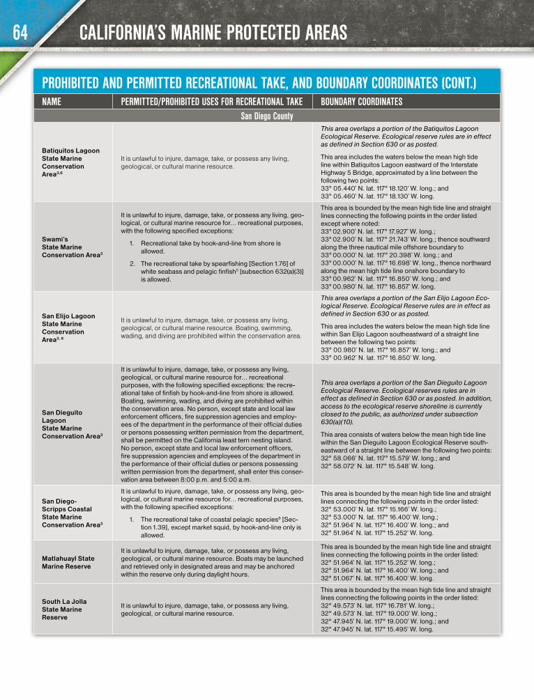
CALIFORNIA’S MARINE PROTECTED AREAS
PROHIBITED AND PERMITTED RECREATIONAL TAKE, AND BOUNDARY COORDINATES (CONT.)NAME PERMITTED/PROHIBITED USES FOR RECREATIONAL TAKE BOUNDARY COORDINATES
San Diego County
Batiquitos Lagoon State Marine Conservation Area3,6
It is unlawful to injure, damage, take, or possess any living, geological, or cultural marine resource.
This area overlaps a portion of the Batiquitos Lagoon Ecological Reserve. Ecological reserve rules are in effect as defined in Section 630 or as posted.
This area includes the waters below the mean high tide line within Batiquitos Lagoon eastward of the Interstate Highway 5 Bridge, approximated by a line between the following two points: 33° 05.440’ N. lat. 117° 18.120’ W. long.; and 33° 05.460’ N. lat. 117° 18.130’ W. long.
Swami’s State Marine Conservation Area3
It is unlawful to injure, damage, take, or possess any living, geo-logical, or cultural marine resource for… recreational purposes, with the following specified exceptions:
1. Recreational take by hook-and-line from shore is allowed.
2. The recreational take by spearfishing [Section 1.76] of white seabass and pelagic finfish5 [subsection 632(a)(3)] is allowed.
This area is bounded by the mean high tide line and straight lines connecting the following points in the order listed except where noted: 33° 02.900’ N. lat. 117° 17.927’ W. long.; 33° 02.900’ N. lat. 117° 21.743’ W. long.; thence southward along the three nautical mile offshore boundary to 33° 00.000’ N. lat. 117° 20.398’ W. long.; and 33° 00.000’ N. lat. 117° 16.698’ W. long., thence northward along the mean high tide line onshore boundary to 33° 00.962’ N. lat. 117° 16.850’ W. long.; and 33° 00.980’ N. lat. 117° 16.857’ W. long.
San Elijo Lagoon State Marine Conservation Area3, 6
It is unlawful to injure, damage, take, or possess any living, geological, or cultural marine resource. Boating, swimming, wading, and diving are prohibited within the conservation area.
This area overlaps a portion of the San Elijo Lagoon Eco-logical Reserve. Ecological Reserve rules are in effect as defined in Section 630 or as posted.
This area includes the waters below the mean high tide line within San Elijo Lagoon southeastward of a straight line between the following two points: 33° 00.980’ N. lat. 117° 16.857’ W. long.; and 33° 00.962’ N. lat. 117° 16.850’ W. long.
San Dieguito Lagoon State Marine Conservation Area3
It is unlawful to injure, damage, take, or possess any living, geological, or cultural marine resource for… recreational purposes, with the following specified exceptions: the recre-ational take of finfish by hook-and-line from shore is allowed. Boating, swimming, wading, and diving are prohibited within the conservation area. No person, except state and local law enforcement officers, fire suppression agencies and employ-ees of the department in the performance of their official duties or persons possessing written permission from the department, shall be permitted on the California least tern nesting island. No person, except state and local law enforcement officers, fire suppression agencies and employees of the department in the performance of their official duties or persons possessing written permission from the department, shall enter this conser-vation area between 8:00 p.m. and 5:00 a.m.
This area overlaps a portion of the San Dieguito Lagoon Ecological Reserve. Ecological reserves rules are in effect as defined in Section 630 or as posted. In addition, access to the ecological reserve shoreline is currently closed to the public, as authorized under subsection 630(a)(10).
This area consists of waters below the mean high tide line within the San Dieguito Lagoon Ecological Reserve south-eastward of a straight line between the following two points: 32° 58.066’ N. lat. 117° 15.579’ W. long.; and 32° 58.072’ N. lat. 117° 15.548’ W. long.
San Diego-Scripps Coastal State Marine Conservation Area3
It is unlawful to injure, damage, take, or possess any living, geo-logical, or cultural marine resource for… recreational purposes, with the following specified exceptions:
1. The recreational take of coastal pelagic species8 [Sec-tion 1.39], except market squid, by hook-and-line only is allowed.
This area is bounded by the mean high tide line and straight lines connecting the following points in the order listed: 32° 53.000’ N. lat. 117° 15.166’ W. long.; 32° 53.000’ N. lat. 117° 16.400’ W. long.; 32° 51.964’ N. lat. 117° 16.400’ W. long.; and 32° 51.964’ N. lat. 117° 15.252’ W. long.
Matlahuayl State Marine Reserve
It is unlawful to injure, damage, take, or possess any living, geological, or cultural marine resource. Boats may be launched and retrieved only in designated areas and may be anchored within the reserve only during daylight hours.
This area is bounded by the mean high tide line and straight lines connecting the following points in the order listed: 32° 51.964’ N. lat. 117° 15.252’ W. long.; 32° 51.964’ N. lat. 117° 16.400’ W. long.; and 32° 51.067’ N. lat. 117° 16.400’ W. long.
South La Jolla State Marine Reserve
It is unlawful to injure, damage, take, or possess any living, geological, or cultural marine resource.
This area is bounded by the mean high tide line and straight lines connecting the following points in the order listed: 32° 49.573’ N. lat. 117° 16.781’ W. long.; 32° 49.573’ N. lat. 117° 19.000’ W. long.; 32° 47.945’ N. lat. 117° 19.000’ W. long.; and 32° 47.945’ N. lat. 117° 15.495’ W. long.
64
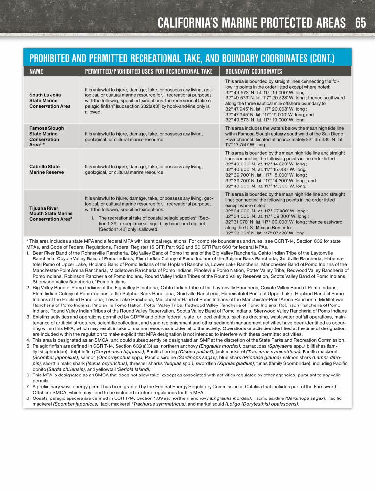
CALIFORNIA’S MARINE PROTECTED AREAS
PROHIBITED AND PERMITTED RECREATIONAL TAKE, AND BOUNDARY COORDINATES (CONT.)NAME PERMITTED/PROHIBITED USES FOR RECREATIONAL TAKE BOUNDARY COORDINATES
South La Jolla State Marine Conservation Area
It is unlawful to injure, damage, take, or possess any living, geo-logical, or cultural marine resource for… recreational purposes, with the following specified exceptions: the recreational take of pelagic finfish5 [subsection 632(a)(3)] by hook-and-line only is allowed.
This area is bounded by straight lines connecting the fol-lowing points in the order listed except where noted: 32° 49.573’ N. lat. 117° 19.000’ W. long.; 32° 49.573’ N. lat. 117° 20.528’ W. long.; thence southward along the three nautical mile offshore boundary to 32° 47.945’ N. lat. 117° 20.068’ W. long.; 32° 47.945’ N. lat. 117° 19.000’ W. long; and 32° 49.573’ N. lat. 117° 19.000’ W. long.
Famosa Slough State Marine Conservation Area3, 6
It is unlawful to injure, damage, take, or possess any living, geological, or cultural marine resource.
This area includes the waters below the mean high tide line within Famosa Slough estuary southward of the San Diego River channel, located at approximately 32° 45.430’ N. lat. 117° 13.750’ W. long.
Cabrillo State Marine Reserve
It is unlawful to injure, damage, take, or possess any living, geological, or cultural marine resource.
This area is bounded by the mean high tide line and straight lines connecting the following points in the order listed: 32° 40.600’ N. lat. 117° 14.820’ W. long.; 32° 40.600’ N. lat. 117° 15.000’ W. long.; 32° 39.700’ N. lat. 117° 15.000’ W. long.; 32° 39.700’ N. lat. 117° 14.300’ W. long.; and 32° 40.000’ N. lat. 117° 14.300’ W. long.
Tijuana River Mouth State Marine Conservation Area3
It is unlawful to injure, damage, take, or possess any living, geo-logical, or cultural marine resource for… recreational purposes, with the following specified exceptions:
1. The recreational take of coastal pelagic speciesB [Sec-tion 1.39], except market squid, by hand-held dip net [Section 1.42] only is allowed.
This area is bounded by the mean high tide line and straight lines connecting the following points in the order listed except where noted: 32° 34.000’ N. lat. 117° 07.980’ W. long.; 32° 34.000’ N. lat. 117° 09.000’ W. long.; 32° 31.970’ N. lat. 117° 09.000’ W. long.; thence eastward along the U.S.-Mexico Border to 32° 32.064’ N. lat. 117° 07.428’ W. long.
* This area includes a state MPA and a federal MPA with identical regulations. For complete boundaries and rules, see CCR T-14, Section 632 for state MPAs, and Code of Federal Regulations, Federal Register 15 CFR Part 922 and 50 CFR Part 660 for federal MPAs.1. Bear River Band of the Rohnerville Rancheria, Big Valley Band of Pomo Indians of the Big Valley Rancheria, Cahto Indian Tribe of the Laytonville
Rancheria, Coyote Valley Band of Pomo Indians, Elem Indian Colony of Pomo Indians of the Sulphur Bank Rancheria, Guidiville Rancheria, Habema-tolel Pomo of Upper Lake, Hopland Band of Pomo Indians of the Hopland Rancheria, Lower Lake Rancheria, Manchester Band of Pomo Indians of the Manchester-Point Arena Rancheria, Middletown Rancheria of Pomo Indians, Pinoleville Pomo Nation, Potter Valley Tribe, Redwood Valley Rancheria of Pomo Indians, Robinson Rancheria of Pomo Indians, Round Valley Indian Tribes of the Round Valley Reservation, Scotts Valley Band of Pomo Indians, Sherwood Valley Rancheria of Pomo Indians
2. Big Valley Band of Pomo Indians of the Big Valley Rancheria, Cahto Indian Tribe of the Laytonville Rancheria, Coyote Valley Band of Pomo Indians, Elem Indian Colony of Pomo Indians of the Sulphur Bank Rancheria, Guidiville Rancheria, Habematolel Pomo of Upper Lake, Hopland Band of Pomo Indians of the Hopland Rancheria, Lower Lake Rancheria, Manchester Band of Pomo Indians of the Manchester-Point Arena Rancheria, Middletown Rancheria of Pomo Indians, Pinoleville Pomo Nation, Potter Valley Tribe, Redwood Valley Rancheria of Pomo Indians, Robinson Rancheria of Pomo Indians, Round Valley Indian Tribes of the Round Valley Reservation, Scotts Valley Band of Pomo Indians, Sherwood Valley Rancheria of Pomo Indians
3. Existing activities and operations permitted by CDFW and other federal, state, or local entities, such as dredging, wastewater outfall operations, main-tenance of artificial structures, scientific collecting, and sand replenishment and other sediment management activities have been identified as occur-ring within this MPA, which may result in take of marine resources incidental to the activity. Operations or activities identified at the time of designation are included within the regulation to make explicit that MPA designation is not intended to interfere with these permitted activities.
4. This area is designated as an SMCA, and could subsequently be designated an SMP at the discretion of the State Parks and Recreation Commission.5. Pelagic finfish are defined in CCR T-14, Section 632(a)(3) as: northern anchovy (Engraulis mordax), barracudas (Sphyraena spp.), billfishes (fam-
ily Istiophoridae), dolphinfish (Coryphaena hippurus), Pacific herring (Clupea pallasii), jack mackerel (Trachurus symmetricus), Pacific mackerel (Scomber japonicus), salmon (Oncorhynchus spp.), Pacific sardine (Sardinops sagax), blue shark (Prionace glauca), salmon shark (Lamna ditro-pis), shortfin mako shark (Isurus oxyrinchus), thresher sharks (Alopias spp.), swordfish (Xiphias gladius), tunas (family Scombridae), including Pacific bonito (Sarda chiliensis), and yellowtail (Seriola lalandi).
6. This MPA is designated as an SMCA that does not allow take, except as associated with activities regulated by other agencies, pursuant to any valid permits.
7. A preliminary wave energy permit has been granted by the Federal Energy Regulatory Commission at Catalina that includes part of the Farnsworth Offshore SMCA, which may need to be included in future regulations for this MPA.
8. Coastal pelagic species are defined in CCR T-14, Section 1.39 as: northern anchovy (Engraulis mordax), Pacific sardine (Sardinops sagax), Pacific mackerel (Scomber japonicus), jack mackerel (Trachurus symmetricus), and market squid (Loligo (Doryteuthis) opalescens).
65

HEALTH ADVISORIES
PUBLIC HEALTH ADVISORIES AND GUIDANCE ON SPORT FISH CONSUMPTIONFish are an excellent source of protein and ben-eficial fats, and are recommended as part of a healthy, balanced diet. It is important, however, to choose the fish you eat wisely.
The Office of Environmental Health Hazard Assessment (OEHHA) provides the guidelines below. For more information, visit the OEH-HA website at www.oehha.ca.gov/fish or call (916) 324-7572.
The U.S. Food and Drug Administration and the U.S. Environmental Protection Agency issued a joint “Federal Advisory for Mercury in Fish” for fish you buy at stores and restaurants. The federal advisory can be found online at www.fda.gov/food/resourcesforyou/consumers/ucm110591.htm.
FISH PREPARATION AND CONSUMPTIONEat only the fillet portions of fish and the meat of crabs. Cook the fish thoroughly and allow juice to drain away. Do not eat the guts or internal organs because chemicals usually concentrate in these parts. Also, avoid frequent consumption of any reproductive parts such as eggs or roe. If you make stews or chowders, use fillet parts.
Many chemicals are stored in the fat. When advisories are based on PCBs or pesticides (DDTs
or dieldrin), skin the fish, when possible, do not eat the skin, and trim any visible fat to reduce the levels of these chemicals. Removing fat will not reduce mercury levels.
SAFE EATING GUIDELINESOEHHA gives special guidelines for women ages 18-45 years and children 1-17 years because chil-dren and fetuses are more sensitive to chemicals. Women over 45 years and men have less risk and can safely eat more fish, as shown in the following tables.
The consumption guidelines in the tables are based on the chemicals noted in each table. Fish
Remove all skin
Fat - Remove the fatty dark meat along the entire length of the fillet
Remove all fat along the back
Remove the belly
Remove guts
fish sketch courtesy OEHHA
SERVINGS PER WEEK
SPECIESWOMEN AGES 18-45 AND CHILDREN 1-17
YEARS
WOMEN 46 YEARS AND OLDER, AND MEN 18 YEARS AND OLDER
Anadromous Fish*ADVICE BASED ON MERCURY
American shad or 3 7
Chinook (king) salmon or 2 7
Striped bass or Do Not Eat 2
White sturgeon Do Not Eat 1
This advice does not apply to these fish when caught in lakes or reservoirs.*Fish that migrate between ocean and fresh water
SERVINGS PER WEEK
SPECIESWOMEN AGES 18-45 AND CHILDREN 1-17
YEARS
WOMEN 46 YEARS AND OLDER, AND MEN 18 YEARS AND OLDER
Tomales Bay (Marin County)ADVICE BASED ON MERCURY
Brown smoothhound shark Do Not Eat Do Not Eat
Leopard shark or Do Not Eat 1
Pacific angel shark or Do Not Eat 1
Bat rays or Do Not Eat 1
California halibut or 1 3
Red rock crab or 1 3
Surfperches or 2 7
Jacksmelt 3 7
This advisory does not apply to commercially grown Tomales Bay oysters, clams, and mussels, which do not contain high levels of mercury.
FISH CONSUMPTION GUIDELINES
consumption recommendations in the following tables are provided as the number of servings per week. A serving is about the size and thickness of your hand. Give children smaller servings.
The guidelines for each species and area assume that no other fish are being eaten in the same week.
These safe eating guidelines are for fish from marine and anadromous waters only. OEHHA’s guidelines for freshwater fish can be found in the CDFW’s Freshwater Sport Fishing regulations booklet, available wherever sport fishing licenses are sold, at your local CDFW office, and online at wildlife.ca.gov/regulations.
If you do not see your specific location in these tables, follow OEHHA’s Eating Fish from Cali-fornia Coastal Locations Without Site-Specific Advice located online at oehha.ca.gov/advisories/statewide-advisory-eating-fish-california-coast-al-locations-without-site-specific-advice or OEHHA’s Advisory for Fish that Migrate locat-ed online at oehha.ca.gov/advisories/adviso-ry-fish-migrate.
WHAT IS A SERVING?
The recommended serving of fish is about the size and thickness of your hand.
Give children smaller servings.
For Adults For Children
66
2017–2018 CALIFORNIA SALTWATER FISHING REGULATIONS

HEALTH ADVISORIES
SERVINGS PER WEEK
SPECIESWOMEN AGES 18-45 AND CHILDREN 1-17
YEARS
WOMEN 46 YEARS AND OLDER, AND MEN 18 YEARS AND OLDER
Mission BayADVICE BASED ON PCBs OR MERCURY
Diamond or spotted turbot, opaleye or 7 7
Topsmelt or 6 7
Black perch, white or rainbow surfperch or 3 7
Shiner or striped mullet or 3 3
Yellowfin croaker or 2 5
Spotted sand bass, brown smoothhound shark 1 3
Do not combine recommendations. For example, if you eat three servings of striped mullet, do not eat any more fish until the following week.
San Diego BayADVICE BASED ON PCBs OR MERCURY
Diamond or spotted turbot, black perch, pile perch, rainbow surfperch, California lizardfish or
2 2
Round stingray, shovelnose guitarfish or 1 2
Pacific chub mackerel or 1 1
Spotted or barred sand bass, yellowfin croaker, leopard shark, gray smoothhound shark
Do Not Eat 1
Topsmelt, shiner perch Do Not Eat Do Not Eat
Do not combine recommendations. For example, if you eat one serving of Pacific chub mackerel, do not eat any more fish until the following week.
San Francisco BayADVICE BASED ON MERCURY
Chinook (king) salmon or 2 7
Brown rockfish or 2 5
Red rock crab or 2 5
Jacksmelt or 2 2
California halibut or 1 2
Striped bass or Do Not Eat 2
White croaker, skinless fillet only, or 1 1
Sharks or Do Not Eat 1
White sturgeon Do Not Eat 1
Surfperches Do Not Eat Do Not Eat
Because of high concentrations of dieldrin or DDTs or both, OEHHA recom-mends that no one eat fish from the Lauritzen Channel in Richmond Inner Harbor.
Elkhorn Slough
Asian clam (Corbicula), speckled sanddab or 7 7
Surfperches or 3 4
Bat ray under 24 in. wide or 1 4
Bat ray 24 in. wide or more, leopard shark Do Not Eat 1
Do not combine recommendations.
SERVINGS PER WEEK
SPECIESWOMEN AGES 18-45 AND CHILDREN 1-17
YEARS
WOMEN 46 YEARS AND OLDER, AND MEN 18 YEARS AND OLDER
Ventura Harbor to Santa Monica Pier and south of Seal Beach Pier to San Mateo PointADVICE BASED ON PCBs OR MERCURY
Jacksmelt or 4 7
Pacific chub mackerel or 2 4
Corbina, yellowfin croaker, queenfish, surfperches, opaleye, topsmelt or
2 2
California halibut, rockfishes, barred sand bass, white croaker, shovelnose guitarfish or
1 2
Sargo, kelp bass, sardines, Cali-fornia scorpionfish (sculpin) or 1 1
Barracuda, black croaker Do Not Eat 1
Do not combine recommendations. For example, if you eat one serving of kelp bass, do not eat any more fish until the following week.
Santa Monica Beach south of Santa Monica Pier to Seal Beach PierADVICE BASED ON PCBs OR MERCURY
Jacksmelt or 4 7
Pacific chub mackerel or 2 4
Corbina, yellowfin croaker, queenfish, surfperches, opaleye or
2 2
California halibut, rockfishes, shovelnose guitarfish or 1 2
Sargo, kelp bass, sardines, Cali-fornia scorpionfish (sculpin), or 1 1
Barracuda, black croaker Do Not Eat 1
Topsmelt, barred sand bass, white croaker Do Not Eat Do Not Eat
Do not combine recommendations. For example, if you eat one serving of kelp bass, do not eat any more fish until the following week.
Statewide Advisory for Eating Fish from California Coastal Locations without Site-Specific Advice
Small flatfish or 6 6
Topsmelt, barred, rainbow spotfin or white surfperch, black or pile perch or
2 6
Shiner perch, silver or walleye surfperch or 2 2
Black, blue, brown,kelp, olive,rosethorn, or vermilion rockfish or
1 4
Barred sand bass, cabezon, kelp bass, lingcod or 1 2
California corbina or 1 1
Black-and-yellow, China, cop-per, or gopher rockfish, sharks Do Not Eat 1
Do not combine recommendations. For example, if you eat one serving of California corbina, do not eat any more fish until the following week.
FISH CONSUMPTION GUIDELINES
67
2017–2018 CALIFORNIA SALTWATER FISHING REGULATIONS

MARINE FINFISH REGULATIONS INDEX
2017 TABLE OF APPLICABLE SPORTFISHING REGULATIONS FOR MARINE FINFISH BY SPECIES
SPECIESINDIVIDUAL
DAILY BAG AND POSSESSION
LIMITSIZE LIMIT
SEASONAL CLOSURES, AREA CLOSURES AND DEPTH RESTRICTIONS
FILLET LENGTH, SKIN REQUIREMENT AT SEA
GEAR RESTRICTIONS OR METHODS OF TAKE
Anchovy, northern Sec. 27.60(b) - - Sec. 27.65(b)(12) Sec. 28.65, 28.80, 28.90, 28.91, 28.95
Barracuda, Calif. Sec. 27.60(a) Sec. 28.25 - Sec. 27.65(b)(2) Sec. 28.65, 28.90, 28.91, 28.95
Bass, giant sea (a.k.a. black sea bass) Sec. 28.10 (a and b) May not be taken off California; Sec. 28.10(a), 28.90 and 28.95
Basses - kelp, barred sand and spotted sand Sec. 28.30(b) Sec. 28.30(a) - Sec. 27.65(b)(1) Sec. 28.65, 28.90, 28.91,
28.95
Bass, striped Sec. 27.85(b) Sec. 27.85(c)(1) and (2) Sec. 27.85(a) Sec. 27.65(c) Sec. 27.85(d), 28.28(d),
28.90, 28.91, 28.95
Bonito, Pacific Sec. 28.32(a) Sec. 28.32(b) - Sec. 27.65(b)(5) Sec. 28.65, 28.90, 28.91, 28.95
Butterfish, Pacific (a.k.a. Pacific pompano) Sec. 27.60(b) - - Sec. 27.65(b)(12) Sec. 28.65, 28.90, 28.91,
28.95
Cabezon1 Sec. 28.28(b) Sec. 28.28(c) Sec. 27.20 through 27.51 Sec. 27.65(c) Sec. 28.65(c), 28.90, 28.91, 28.95
Coastal Pelagic Species as defined in Sec. 1.39 See regulations for individual species
Cod, Pacific1 Sec. 27.60(a), 28.49(b)(3) - Sec. 27.20 through 27.51 Sec. 27.65(b)(12) Sec. 28.65, 28.90, 28.91,
28.95
Codling1 Sec. 27.60(a), 28.49(b)(3) - Sec. 27.20 through 27.51 Sec. 27.65(b)(12) Sec. 28.65, 28.90, 28.91,
28.95.
Dolphinfish (a.k.a. dorado) Sec. 27.60(a) - - Sec. 27.65(b)(12) Sec. 28.65, 28.90, 28.91,
28.95
Fish, Other1 as defined in Sec. 1.91(a)(11) See regulations for individual species
Flatfish, Federally Man-aged1 as defined in Sec. 1.91(a)(9)
Sec. 27.60(a), 28.49(b) - Sec. 27.20 through 27.51 Sec. 27.65(b)(12) Sec. 28.65, 28.90, 28.91,
28.95
Flatfish, Other1 as defined in Sec. 1.91(a)(10)
Sec. 27.60(a), 28.48(b) - Sec. 28.48(a) Sec. 27.65(b)(12) Sec. 28.65, 28.90, 28.91,
28.95
Flounder, Starry Sec. 28.47(b) - Sec. 28.47(a) Sec. 27.65(b)(12) Sec. 28.65, 28.90, 28.91,28.95
Garibaldi Take or possession is Prohibited; Sec. 28.05, 28.90, 28.95
Greenlings - kelp and rock1 (a.k.a. sea trout) Sec. 28.29(b) Sec. 28.29(c) Sec. 27.20 through 27.51 Sec. 27.65(c) Sec. 28.29(d), 28.65(c),
28.90, 28.91, 28.95
Groundfish, Federal1 as defined in Sec. 1.91(a) See regulations for individual species Sec. 27.20 through 27.51,
28.47(a) and 28.48(a) See regulations for individual species
Groupers - gulf and broomtail Take or possession is Prohibited; Sec. 28.12, 28.90, 28.95
Grunion, Calif. Sec. 27.60(b) - Sec. 28.00 Sec. 27.65(b)(12) Sec. 29.00
Halibut, Calif. Sec. 28.15(a) Sec. 28.15(b) -Sec. 27.65(b)(6) south of Pt. Arena, Sec. 27.65(c)
north of Pt. Arena
Sec. 28.65, 28.90, 28.91, 28.95
Halibut, Pacific Sec. 28.20(b) Sec. 28.20(c) Sec. 28.20(a) Sec. 27.65(b)(12) Sec. 28.20(d), 28.65, 28.90, 28.91, 28.95
Herring, Pacific Sec. 27.60(b) - - Sec. 27.65(b)(12) Sec. 28.65, 28.80, 28.90, 28.91, 28.95
Herring, round Sec. 27.60(b) - - Sec. 27.65(b)(12) Sec. 28.65, 28.80, 28.90, 28.91, 28.95
Highly Migratory Species as defined in Sec. 1.49 See regulations for individual species
Jacksmelt Sec. 27.60(b) - - Sec. 27.65(b)(12) Sec. 28.65, 28.90, 28.91, 28.95
Listed in alphabetical order by species; references regulations pertaining to all species mentioned in the 2017-2018 California Saltwater Sport Fishing Regulations booklet and CCR T-14.
68
2017–2018 CALIFORNIA SALTWATER FISHING REGULATIONS
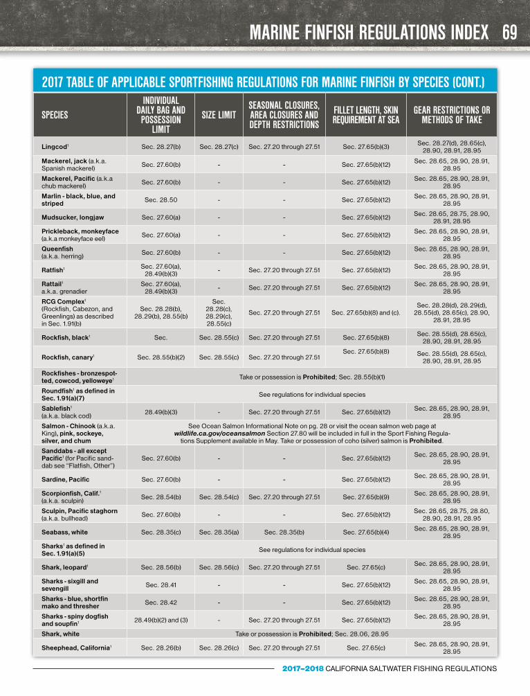
MARINE FINFISH REGULATIONS INDEX
2017 TABLE OF APPLICABLE SPORTFISHING REGULATIONS FOR MARINE FINFISH BY SPECIES (CONT.)
SPECIESINDIVIDUAL
DAILY BAG AND POSSESSION
LIMITSIZE LIMIT
SEASONAL CLOSURES, AREA CLOSURES AND DEPTH RESTRICTIONS
FILLET LENGTH, SKIN REQUIREMENT AT SEA
GEAR RESTRICTIONS OR METHODS OF TAKE
Lingcod1 Sec. 28.27(b) Sec. 28.27(c) Sec. 27.20 through 27.51 Sec. 27.65(b)(3) Sec. 28.27(d), 28.65(c), 28.90, 28.91, 28.95
Mackerel, jack (a.k.a. Spanish mackerel) Sec. 27.60(b) - - Sec. 27.65(b)(12) Sec. 28.65, 28.90, 28.91,
28.95
Mackerel, Pacific (a.k.a chub mackerel) Sec. 27.60(b) - - Sec. 27.65(b)(12) Sec. 28.65, 28.90, 28.91,
28.95
Marlin - black, blue, and striped Sec. 28.50 - - Sec. 27.65(b)(12) Sec. 28.65, 28.90, 28.91,
28.95
Mudsucker, longjaw Sec. 27.60(a) - - Sec. 27.65(b)(12) Sec. 28.65, 28.75, 28.90, 28.91, 28.95
Prickleback, monkeyface (a.k.a monkeyface eel) Sec. 27.60(a) - - Sec. 27.65(b)(12) Sec. 28.65, 28.90, 28.91,
28.95
Queenfish (a.k.a. herring) Sec. 27.60(b) - - Sec. 27.65(b)(12) Sec. 28.65, 28.90, 28.91,
28.95
Ratfish1 Sec. 27.60(a), 28.49(b)(3) - Sec. 27.20 through 27.51 Sec. 27.65(b)(12) Sec. 28.65, 28.90, 28.91,
28.95
Rattail1 a.k.a. grenadier
Sec. 27.60(a), 28.49(b)(3) - Sec. 27.20 through 27.51 Sec. 27.65(b)(12) Sec. 28.65, 28.90, 28.91,
28.95
RCG Complex1 (Rockfish, Cabezon, and Greenlings) as described in Sec. 1.91(b)
Sec. 28.28(b), 28.29(b), 28.55(b)
Sec. 28.28(c), 28.29(c), 28.55(c)
Sec. 27.20 through 27.51 Sec. 27.65(b)(8) and (c). Sec. 28.28(d), 28.29(d),
28.55(d), 28.65(c), 28.90, 28.91, 28.95
Rockfish, black1 Sec. Sec. 28.55(c) Sec. 27.20 through 27.51 Sec. 27.65(b)(8) Sec. 28.55(d), 28.65(c), 28.90, 28.91, 28.95
Rockfish, canary1 Sec. 28.55(b)(2) Sec. 28.55(c) Sec. 27.20 through 27.51Sec. 27.65(b)(8)
Sec. 28.55(d), 28.65(c), 28.90, 28.91, 28.95
Rockfishes - bronzespot-ted, cowcod, yelloweye1 Take or possession is Prohibited; Sec. 28.55(b)(1)
Roundfish1 as defined in Sec. 1.91(a)(7) See regulations for individual species
Sablefish1 (a.k.a. black cod) 28.49(b)(3) - Sec. 27.20 through 27.51 Sec. 27.65(b)(12) Sec. 28.65, 28.90, 28.91,
28.95
Salmon - Chinook (a.k.a. King), pink, sockeye, silver, and chum
See Ocean Salmon Informational Note on pg. 28 or visit the ocean salmon web page at wildlife.ca.gov/oceansalmon Section 27.80 will be included in full in the Sport Fishing Regula-
tions Supplement available in May. Take or possession of coho (silver) salmon is Prohibited.
Sanddabs - all except Pacific1 (for Pacific sand-dab see “Flatfish, Other”)
Sec. 27.60(b) - - Sec. 27.65(b)(12) Sec. 28.65, 28.90, 28.91, 28.95
Sardine, Pacific Sec. 27.60(b) - - Sec. 27.65(b)(12) Sec. 28.65, 28.90, 28.91, 28.95
Scorpionfish, Calif.1 (a.k.a. sculpin) Sec. 28.54(b) Sec. 28.54(c) Sec. 27.20 through 27.51 Sec. 27.65(b)(9) Sec. 28.65, 28.90, 28.91,
28.95
Sculpin, Pacific staghorn (a.k.a. bullhead) Sec. 27.60(b) - - Sec. 27.65(b)(12) Sec. 28.65, 28.75, 28.80,
28.90, 28.91, 28.95
Seabass, white Sec. 28.35(c) Sec. 28.35(a) Sec. 28.35(b) Sec. 27.65(b)(4) Sec. 28.65, 28.90, 28.91, 28.95
Sharks1 as defined in Sec. 1.91(a)(5) See regulations for individual species
Shark, leopard1 Sec. 28.56(b) Sec. 28.56(c) Sec. 27.20 through 27.51 Sec. 27.65(c) Sec. 28.65, 28.90, 28.91, 28.95
Sharks - sixgill and sevengill Sec. 28.41 - - Sec. 27.65(b)(12) Sec. 28.65, 28.90, 28.91,
28.95
Sharks - blue, shortfin mako and thresher Sec. 28.42 - - Sec. 27.65(b)(12) Sec. 28.65, 28.90, 28.91,
28.95
Sharks - spiny dogfish and soupfin1 28.49(b)(2) and (3) - Sec. 27.20 through 27.51 Sec. 27.65(b)(12) Sec. 28.65, 28.90, 28.91,
28.95
Shark, white Take or possession is Prohibited; Sec. 28.06, 28.95
Sheephead, California1 Sec. 28.26(b) Sec. 28.26(c) Sec. 27.20 through 27.51 Sec. 27.65(c) Sec. 28.65, 28.90, 28.91, 28.95
69
2017–2018 CALIFORNIA SALTWATER FISHING REGULATIONS

MARINE FINFISH REGULATIONS INDEX
2017 TABLE OF APPLICABLE SPORTFISHING REGULATIONS FOR MARINE FINFISH BY SPECIES (CONT.)
SPECIESINDIVIDUAL
DAILY BAG AND POSSESSION
LIMITSIZE LIMIT
SEASONAL CLOSURES, AREA CLOSURES AND DEPTH RESTRICTIONS
FILLET LENGTH, SKIN REQUIREMENT AT SEA
GEAR RESTRICTIONS OR METHODS OF TAKE
Skate - big, California, and longnose1 as defined in Sec. 1.91(a)(6)
28.49(b)(3) - Sec. 27.20 through 27.51 Sec. 27.65(b)(12) Sec. 28.65, 28.90, 28.91, 28.95
Smelt, surf Sec. 28.45 - - Sec. 27.65(b)(12) Sec. 28.65, 28.80, 28.85, 28.90, 28.91, 28.95
Steelhead Take or possession is Prohibited; Sec. 27.70(b)
Sole, Petrale1 Sec. 28.47(b) - Sec. 28.47(a) Sec. 27.65(b)(12) Sec. 28.65, 28.90, 28.91, 28.95
Sturgeon, white Sec. 27.90(b) Sec. 27.90(c) Sec. 27.90(a), 27.95 Sec. 27.65(c) Sec. 27.90(d) and (e), 28.65, 28.90, 28.91, 28.95
Sturgeon, green Take or possession is Prohibited; Sec. 27.91(a)
Surfperches, general Sec. 28.59(c)(1) Sec. 28.59(d) Sec. 28.59(b) Sec. 27.65(b)(11), Sec 27.65(c)
Sec. 28.65, 28.90, 28.91, 28.95
Surfperch, shiner Sec. 28.59(c)(2) Sec. 28.59(d) Sec. 28.59(b) Sec. 27.65(b)(12) Sec. 28.65, 28.75, 28.80, 28.90, 28.91, 28.95
Swordfish, broadbill Sec. 28.40 - - Sec. 27.65(b)(12) Sec. 28.65, 28.90, 28.91, 28.95
Thornyheads - longspine and shortspine1 Sec. 1.91(a)(8)
Sec. 28.49(b)(3) - Sec. 27.20 through 27.51 Sec. 27.65(b)(12) Sec. 28.65, 28.90, 28.91, 28.95
Topsmelt Sec. 27.60(b) - - Sec. 27.65(b)(12) Sec. 28.65, 28.90, 28.91, 28.95
Trout (other than steelhead) Sec. 27.70(b) - - Sec. 27.65(b)(12) Sec. 27.70(a), 28.65, 28.90,
28.91, 28.95
Tuna, albacore Sec. 28.38(a) - -
Sec. 27.65(b)(11) south of Pt. Conception
Sec. 27.65(b)(12) north of Pt. Conception
Sec. 28.65, 28.90, 28.91, 28.95
Tuna, bluefin Sec. 28.38(b) - -
Sec. 27.65(b)(11) south of Pt. Conception
Sec. 27.65(b)(12) north of Pt. Conception
Sec. 28.65, 28.90, 28.91, 28.95
Tuna, skipjack Sec. 27.60(b), 28.38(c) - -
Sec. 27.65(b)(11) south of Pt. Conception
Sec. 27.65(b)(12) north of Pt. Conception
Sec. 28.65, 28.90, 28.91, 28.95
Tunas - bigeye and yellowfin
Sec. 27.60(a), 28.38(d) - -
Sec. 27.65(b)(11) south of Pt. Conception
Sec. 27.65(b)(12) north of Pt. Conception
Sec. 28.65, 28.90, 28.91, 28.95
Whitefish, ocean1 Sec. 27.60(a), 28.58(b) - Sec. 27.20 through 27.51 Sec. 27.65(b)(10) Sec. 28.65, 28.90, 28.91,
28.95
Whiting, Pacific1 (a.k.a. Pacific hake)
Sec. 27.60(a), 28.49(b)(3) - Sec 27.20 through 27.51 Sec. 27.65(b)(12) Sec. 28.65, 28.90, 28.91,
28.95
Yellowtail Sec. 28.37(a) Sec. 28.37(b) - Sec. 27.65(b)(7) Sec. 28.65, 28.90, 28.91, 28.95
All flatfish not listed above (for example, diamond turbot, etc.)
Sec. 27.60(a) - - Sec. 27.65(b)(12) Sec. 28.65, 28.90, 28.91, 28.95
All marine finfish not listed above (including but not limited to: white croaker, opaleye, sargo, Calif. lizardfish, etc.)
Sec. 27.60(a) - - Sec. 27.65(b)(12) Sec. 28.65, 28.90, 28.91, 28.95
1 CDFW may modify seasons, depth constraints, gear restrictions, fillet requirements, and bag and size limits for any species of federally managed groundfish or aggregate group of federal groundfish species, California sheephead, ocean whitefish, and all greenlings.
“ - “ indicates that this requirement for this species is covered under the General Take regulations of Section 27.60 (see pg. 27)
70
2017–2018 CALIFORNIA SALTWATER FISHING REGULATIONS
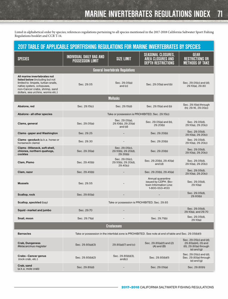
MARINE INVERTEBRATES REGULATIONS INDEX
2017 TABLE OF APPLICABLE SPORTFISHING REGULATIONS FOR MARINE INVERTEBRATES BY SPECIES
SPECIES INDIVIDUAL DAILY BAG AND POSSESSION LIMIT SIZE LIMIT
SEASONAL CLOSURES, AREA CLOSURES AND DEPTH RESTRICTIONS
GEAR RESTRICTIONS OR METHODS OF TAKE
General Invertebrate RegulationsAll marine invertebrates not listed below (including but not limited to: limpets, turban snails, native oysters, octopuses, non-Cancer crabs, shrimp, sand dollars, sea urchins, worms etc.)
Sec. 29.05 Sec. 29.05(a) and (c) Sec. 29.05(a) and (b) Sec. 29.05(c) and (d);
29.10(a), 29.80
Mollusks
Abalone, red Sec. 29.15(c) Sec. 29.15(d) Sec. 29.15(a) and (b) Sec. 29.15(e) through (h); 29.16, 29.05(c)
Abalone - all other species Take or possession is PROHIBITED; Sec. 29.15(c)
Clams, general Sec. 29.05(a)Sec. 29.05(a),
29.10(b), 29.20(a) and (d)
Sec. 29.05(a) and (b), 29.20(b)
Sec. 29.05(d), 29.10(a), 29.20(c)
Clams - gaper and Washington Sec. 29.25 - Sec. 29.20(b) Sec. 29.05(d), 29.10(a), 29.20(c)
Clams - geoduck (a.k.a. horse or horseneck clams) Sec. 29.30 - Sec. 29.20(b) Sec. 29.05(d),
29.10(a), 29.20(c)
Clams - littleneck, soft-shell, chiones, northern quahogs, cockles
Sec. 29.35(a)Sec. 29.05(c),
29.10(b), 29.20(d), 29.35(b)
Sec. 29.20(b) Sec. 29.05(d), 29.10(a), 29.20(c)
Clam, Pismo Sec. 29.40(b)Sec. 29.05(c),
29.10(b), 29.20(d), 29.40(c)
Sec. 29.20(b), 29.40(a) and (d)
Sec. 29.05(d), 29.10(a), 29.20(c)
Clam, razor Sec. 29.45(b) - Sec. 29.20(b), 29.45(a) Sec. 29.05(d), 29.10(a), 29.20(c)
Mussels Sec. 29.55 -
Annual quarantine issued by CDPH. Bio-toxin Information Line:
1-800-553-4133
Sec. 29.05(d), 29.10(a)
Scallop, rock Sec. 29.60(a) - - Sec. 29.05(d), 29.60(b)
Scallop, speckled (bay) Take or possession is PROHIBITED; Sec. 29.65
Squid - market and jumbo Sec. 29.70 - - Sec. 29.05(d), 29.10(a), and 29.70
Snail, moon Sec. 29.71(a) - Sec. 29.71(b) Sec. 29.05(d), 29.10(a)
Crustaceans
Barnacles Take or possession in the intertidal zone is PROHIBITED. See note at end of table and Sec. 29.05(b)(1)
Crab, Dungeness Metacarcinus magister Sec. 29.85(a)(3) 29.85(a)(7) and (c) Sec. 29.85(a)(1) and (2)
(A) and (B)
Sec. 29.05(c) and (d); 29.85(a)(4), (5) and
(6), 29.80(a) through (e) and (g)
Crabs - Cancer genus (rock crab, etc.) Sec. 29.85(b)(2) Sec. 29.85(b)(3),
and(c) Sec. 29.85(b)(1)Sec. 29.05(c) and (d); Sec. 29.80(a) through
(e) and (g)
Crab, sand (a.k.a. mole crab) Sec. 29.85(d) - Sec. 29.05(a) Sec. 29.80(h)
Listed in alphabetical order by species; references regulations pertaining to all species mentioned in the 2017-2018 California Saltwater Sport Fishing Regulations booklet and CCR T-14.
71
2017–2018 CALIFORNIA SALTWATER FISHING REGULATIONS

MARINE INVERTEBRATES REGULATIONS INDEX
2017 TABLE OF APPLICABLE SPORTFISHING REGULATIONS FOR MARINE INVERTEBRATES BY SPECIES (CONT.)
SPECIES INDIVIDUAL DAILY BAG AND POSSESSION LIMIT SIZE LIMIT
SEASONAL CLOSURES, AREA CLOSURES AND DEPTH RESTRICTIONS
GEAR RESTRICTIONS OR METHODS OF TAKE
Lobster, spiny Sec. 29.90(b) 29.90(c) and (e) Sec. 29.90(a)Sec. 29.05(c) and (d); Sec. 29.80(a), (b) and
(g), 29.90(d)
Shrimp, bay (a.k.a. grass shrimp) Sec. 29.86 - Sec. 29.05(a) and (b) Sec. 29.80(a), (f)
through (j)
Shrimp - ghost and blue mud Sec. 29.87 - Sec. 29.05(a) and (b) Sec. 29.80(a), (f) through (j)
Shrimp, coonstripe Sec. 29.88(b) - Sec. 29.05(a) Sec. 29.80(a), (f) through (j)
“-” indicates that this requirement for this species is covered under the General regulations of CCR T-14, Section 29.05(a).
Note: Except for the species listed above (see Section 29.05(b)(1)), “tidal invertebrates may not be taken in any tidepool or other areas between the high tide mark (defined as Mean Higher High Tide) and 1,000 ft. seawards and lateral to the low tide mark (defined as Mean Lower Low Water).”
CALIFORNIA FISHING PASSPORT
Capture a Lifetime of Great Catches in your Free California Fishing Passport
Available from your local CDFW office or California Fishing Passport stamping agent or sponsor.
For program details visit: www.wildlife.ca.gov/fishing/passport
California Fishing Passport
passport.cover.indd 1
5/17/2016 11:04:48 AM
HELP FISH LIKE THIS SURVIVE!
Fish floating at the surface like this can survive…with your help.
When fish that possess swim bladders are brought up from depth, decreasing pressure may injure them (known as pressure shock, or ‘barotrauma’). When released, these fish often float helplessly at the surface. Injured fish that cannot descend on their own are especially easy targets for sea gulls and sea lions. Helping fish to descend significantly increases their chances of survival.
You can transport injured fish down to the sea floor using one of the following:• A weighted, inverted barbless hook• A fish-descending device available
at your local tackle shop• An inverted, weighted plastic crate
with a rope attached to the bottom
For more information visit the CDFW website at wildlife.ca.gov/conserva-tion/marine/groundfish/barotrauma or pick up an informational brochure at your local CDFW office.
CDFW photo by E. Jarvis
AVOID PENALTIES AND HELP TO MANAGE OUR NATURAL RESOURCES
Return your Abalone, Spiny Lobster and Sturgeon report cards on time. It’s the law!
72
2017–2018 CALIFORNIA SALTWATER FISHING REGULATIONS

All policies subject to limits and exclusions. In the state of California, the BoatU.S. Marine Insurance Program is provided through Boat Owners Association Insurance Services, CA License #0H87086.
THE DAY’S BIG CATCHSHOULD BE YOUR ONLY FOCUS
Insurance coverage through BoatU.S. makes for a great start to what could be an epic day of fishing. Weprovide coverage for the things that are important to you...your boat, engine and equipment. Our policiesare designed with coverages custom-made for Anglers and include 24/7 claims service from boating experts.
Log-on to BoatUS.com/insuranceor call for a free quote 800-283-2883
Agreed Value Coverage for Your Boat, Engine(s) and Boating Equipment • Broad Cruising AreasCharter and Guide Coverage Options Available • Coverage for Fishing Gear • Tournament Coverage
Water Towing and Roadside Assistance from TowBoatU.S. – the Nation’s Largest Fleet
Fishing Regs CA_8.5 x 10.75.indd 1 12/1/16 11:31 AM