California Marine Life Protection Act Initiative Regional ... · California Marine Life Protection...
155
California Marine Life Protection Act Initiative Regional Profile Central Coast Study Region (Pigeon Point to Point Conception, CA) DRAFT FINAL August 2, 2005 (v.2.0) APPENDICES
Transcript of California Marine Life Protection Act Initiative Regional ... · California Marine Life Protection...

California Marine Life Protection Act InitiativeRegional Profile Central Coast Study Region
(Pigeon Point to Point Conception, CA)
DRAFT FINALAugust 2, 2005 (v.2.0)
APPENDICES

MLPA Central Coast Regional Stakeholder GroupCC Regional Profile Appendix DRAFT Final
August 10-11, 2005 Meeting
Appendix I: Regionally Important Species for the MLPA
Contents
1. Spatial Data Layers Available for MPA Planning on the Central Coast - revised 8/1/05
2 (a). List of Fishes Likely to Benefit from the Establishment of Marine Protected Areas in CentralCalifornia
2 (b). List of Invertebrates and Plants Likely to Benefit from the Establishment of Marine ProtectedAreas in Central California
3. Special Status Species

MLPA Central Coast Regional Stakeholder GroupCC Regional Profile Appendix DRAFT Final
August 10-11, 2005 Meeting
1
1: Spatial Data Layers Available for MPA Planning on the Central Coast - revised 8/1/05
Data Category (Feature Class) Data Layer Name
Description (but see metadata for full description)
Geographic Extent Data Source
Available yet?
Uploaded to UCSB Gdb?
Uploaded to UCSB IMS?
Base Coastline1:24,000 scale California coastline statewide Yes Yes Yes
California rocks
California rocks and islets; most part of CA Coastal National Monument statewide BLM Yes
Hillshade bathymetryUndewater "topography" from Digitial Elevation Model statewide CDFG Yes
NOAA Nautical charts NOAA Nautical charts statewide NOAA Yes
Central Coast Study Region
Central Coast Study Region (mean high tide to 3nmi)
Pigeon Pt to Pt. Conception CDFG Yes Yes
MBNMS study region
Monterey Bay National Marine Sanctuary study region
off Golden Gate to Pt. Sal MBNMS Yes Not yet?
Counties Coastal counties statewide Yes Yes Yes
Ports Ports and harbors statewide CDFG Yes Yes Yes
Coastal pointsLocations and names of headlands and points
CC Study region CDFG Yes Yes
Biological Kelp 1989Kelp Coverage - 1989 (from aerial surveys) statewide CDFG Yes Yes Yes
Kelp 1999Kelp Coverage - 1999 (from aerial surveys) statewide CDFG Yes Yes Yes
Kelp 2002Kelp Coverage - 2002 (from aerial surveys) statewide CDFG Yes Yes Yes
Kelp 2003Kelp Coverage - 2003 (from aerial surveys) statewide CDFG Yes Yes Yes
Status

MLPA Central Coast Regional Stakeholder GroupCC Regional Profile Appendix DRAFT Final
August 10-11, 2005 Meeting
2
Kelp UnionUnion of 3 years of kelp data (89,99,02) statewide Brian Kinlan/UCSB Yes
ESI Shoreline types
Shoreline types (n=13) in linear segments (sandy beach, rocky shores, tidal flats, marsh) statewide
NOAA-Environmental Sensitivity Index (as categorized by TNC) Yes Yes Yes
EstuariesEstuaries-categorized as small, medium, large statewide
Multiple sources compiled by TNC Yes Yes Yes
Coastal marshCoastal marsh - includes salt marsh and brackish marsh statewide
Multiple sources compiled by TNC Yes Yes Yes
Eelgrass Eelgrass distribution statewideMultiple sources compiled by TNC Yes Yes Yes
Surfgrass Surfgrass distribution Central Coast Digitized by Tenera Yes
Seabird colonies
Seabird colonies data from Sowls et al 1980; updated by Carter 1992. Colony location and counts of abundance of seabirds. statewide USFWS Yes Yes
Bird breeding coloniesMajor Marine bird breeding colonies
Pt Arena to Pt Sal NOAA Biogeo Yes
Marine mammal haulouts
Marine mammal haulout point locations statewide NOAA (Mark Lowry) Yes Yes
Marine mammal rookeries
Marine mammal rookeries as point locations statewide NOAA (Mark Lowry) Yes Yes
Salmonid stream outlets
Point locations for coastal stream outlets w/ steelhead, chinook, or coho currently present statewide
TNC (from multiple sources) Yes
Cold seep communities
Chemosynthetic biological communities in Monterey Bay Monterey Bay MBARI Yes Yes-draft
Bird biomass densitiesMarine bird biomass by season, all seasons
Pt Arena to Pt Sal NOAA Biogeo Yes Yes Yes

MLPA Central Coast Regional Stakeholder GroupCC Regional Profile Appendix DRAFT Final
August 10-11, 2005 Meeting
3
Bird biomass (Coldwater period)
Marine bird biomass during cold period (La Nina)
Pt Arena to Pt Sal NOAA Biogeo Yes Yes Yes
Bird biomass (Neutral period)
Marine bird biomass during neutral period
Pt Arena to Pt Sal NOAA Biogeo Yes Yes Yes
Bird biomass (Davidson season)
Marine bird biomass by season, Davidson season
Pt Arena to Pt Sal NOAA Biogeo Yes Yes
Bird biomass (Oceanic season)
Marine bird biomass by season, oceanic season
Pt Arena to Pt Sal NOAA Biogeo Yes Yes
Bird biomass (Upwelling season)
Marine bird biomass by season, upwelling season
Pt Arena to Pt Sal NOAA Biogeo Yes Yes Yes
Bird biomass (Warm water period)
Marine bird biomass during warm period (El Nino)
Pt Arena to Pt Sal NOAA Biogeo Yes Yes Yes
Bird densityMarine bird density by season, all seasons
Pt Arena to Pt Sal NOAA Biogeo Yes Yes Yes
Bird density (Cold water period)
Marine bird density during cold period (La Nina)
Pt Arena to Pt Sal NOAA Biogeo Yes Yes Yes
Bird density (Davidson season)
Marine bird density by season, Davidson season
Pt Arena to Pt Sal NOAA Biogeo Yes Yes Yes
Bird density (Neutral period)
Marine bird density during neutral period
Pt Arena to Pt Sal NOAA Biogeo Yes Yes Yes
Bird density (Oceanic season)
Marine bird density by season, oceanic season
Pt Arena to Pt Sal NOAA Biogeo Yes Yes Yes
Bird density (Upwelling season)
Marine bird density by season, upwelling season
Pt Arena to Pt Sal NOAA Biogeo Yes Yes Yes
Bird density (Warm wate period)
Marine bird density during warm period (El Nino)
Pt Arena to Pt Sal NOAA Biogeo Yes Yes Yes
Bird diversityMarine bird diversity by season, all seasons
Pt Arena to Pt Sal NOAA Biogeo Yes Yes Yes
Bird diversity (Cold wate period)
Marine bird diversity during cold period (La Nina)
Pt Arena to Pt Sal NOAA Biogeo Yes Yes Yes
Bird diversity (Davidson season)
Marine bird diversity by season, Davidson season
Pt Arena to Pt Sal NOAA Biogeo Yes Yes Yes
Bird diversity (Neutral period)
Marine bird diversity during neutral period
Pt Arena to Pt Sal NOAA Biogeo Yes Yes Yes

MLPA Central Coast Regional Stakeholder GroupCC Regional Profile Appendix DRAFT Final
August 10-11, 2005 Meeting
4
Bird diversity (Oceanic season)
Marine bird diversity by season, oceanic season
Pt Arena to Pt Sal NOAA Biogeo Yes Yes Yes
Bird Diversity (Upwelling season)
Marine bird diversity by season, upwelling season
Pt Arena to Pt Sal NOAA Biogeo Yes Yes Yes
Bird diversity (Warm water period)
Marine bird diversity during warm period (El Nino)
Pt Arena to Pt Sal NOAA Biogeo Yes Yes Yes
Bird diversity and density
Diversity, density, hot spots marine birds
Pt Arena to Pt Sal NOAA Biogeo Yes Yes Yes
Fish and Bird Density and Diversity
Integration of density & diversity fishes & birds
Pt Arena to Pt Sal NOAA Biogeo Yes Yes Yes
Fish and Bird Diversity Integration of density & diversity fishes & birds
Pt Arena to Pt Sal NOAA Biogeo Yes Yes Yes
Fish and Bird Density Integration of density & diversity fishes & birds
Pt Arena to Pt Sal NOAA Biogeo Yes Yes Yes
Fish Diversity and density
Diversity, density, hot spots demersal fishes
Pt Arena to Pt Sal NOAA Biogeo Yes Yes Yes
Fish Mean Diversity and Density
Mean Species Diversity of demersal fish
Pt Arena to Pt Sal NOAA Biogeo Yes Yes Yes
Fish Diversity and Richness (1977-2001)
Species Richness of demersal rockfish
Pt Arena to Pt Sal NOAA Biogeo Yes Yes Yes
Sea Otter Density (spring)
Density of sea otters in linear coastal segments based on May 2002 counts
Pt Arena to Pt Sal NOAA Biogeo Yes Yes
Sea Otter Counts (Fall)Nov 2001 Northern sea otter counts
Pt Arena to Pt Sal NOAA Biogeo Yes Yes Yes
Sea Otter Counts (Springl)
May 2002 Northern sea otter counts
Pt Arena to Pt Sal NOAA Biogeo Yes Yes Yes

MLPA Central Coast Regional Stakeholder GroupCC Regional Profile Appendix DRAFT Final
August 10-11, 2005 Meeting
5
Substrate Coarse-scale substrate
coarse-scale substrate data (hard and soft bottom, canyons/no canyons) intercepted with 6 depth zones
Pt Reyes to Pt. Conception
Rasterized data from G. Greene et al, 2004, Fisheries Habitat Characterization of the California Yes
Nearshore fine-scale substrate
Fine scale (high resolution, 1-2m) substrate data (hard and soft bottoms) from multibeam and interpreted side scan sonar
Limited to Monterey Bay south to Pt. Sur
CSUMB, USGS, industry data compiled for nearshore region- Yes
Nearshore finescale substrate
Fine scale (high resolution, 1-2m) substrate data (hard and soft bottoms), intercepted with depth zones
Limited to Monterey Bay south to Pt. Sur
CSUMB, USGS and other sources Yes
Pinnacles Pinnacles Central Coast ? Not yet
Canyons Submarine canyons Central Coastderived from Greene et al Yes
Nearshore canyon heads
Point file of canyon heads within 20nmi of shore digtized Central Coast TNC from DEM Yes
BathymetryDepth zones of Central California
Depth zones of Central California (0, 0-30m, 30-100m, 100-200m, 200-3000m, >3000m) Central Coast EFH Depth polygons Yes Yes Yes
Bathymetric complexity
Bathymetric complexity - defined by standard deviation around mean bathymetry within 1km area of grid. statewide
TNC, from 200m DEM Yes
Bathymetric contours at 10m 10 meter depth contours statewide Yes Yes Yes

MLPA Central Coast Regional Stakeholder GroupCC Regional Profile Appendix DRAFT Final
August 10-11, 2005 Meeting
6
Physical California hydrography Coastal rivers and streams statewide Yes Yes Yes
Coastal watershedsCalwater 2.2 hydrologic unitsand watershed basins Central Coast Calwater 2.2
California topography200m Digital Elevation Modelof California statewide Yes Yes Yes
Submarine features Major submarine features Central Coast MBNMS - Yes Yes Yes
OceanographicUpwelling fronts Q1(1985-2004)
Upwelling fronts Q1 (1985-2004)
St. Anthony'sPt. to MussellPt. PFEL Yes
Upwelling fronts Q2(1985-2004)
Upwelling fronts Q2 (1985-2004)
St. Anthony'sPt. to MussellPt. PFEL Yes
Upwelling fronts Q3(1985-2004)
Upwelling fronts Q3 (1985-2004)
St. Anthony'sPt. to MussellPt. PFEL Yes
Upwelling fronts Q4(1985-2004)
Upwelling fronts Q4 (1985-2004)
St. Anthony'sPt. to MussellPt. PFEL Yes
Upwelling areas
Upwelling - nearshore in 3season from SEAWIFFs seasurface temperature data
Pigeon Pt to Pt.Conception Bernardo Broitman Yes
Retention areas Retention areasPigeon Pt to Pt.Conception Bernardo Broitman Yes
Freshwater areasFreshwater plumes ijn 4seasons from Seawiffs data
Pigeon Pt to Pt.Conception Bernardo Broitman Yes
Warm water frontsOligotrophic warm waterfronts
Pigeon Pt to Pt.Conception PFEL NO
MLPA Central Coast Regional Stakeholder GroupCC Regional Profile Appendix DRAFT Final
August 10-11, 2005 Meeting
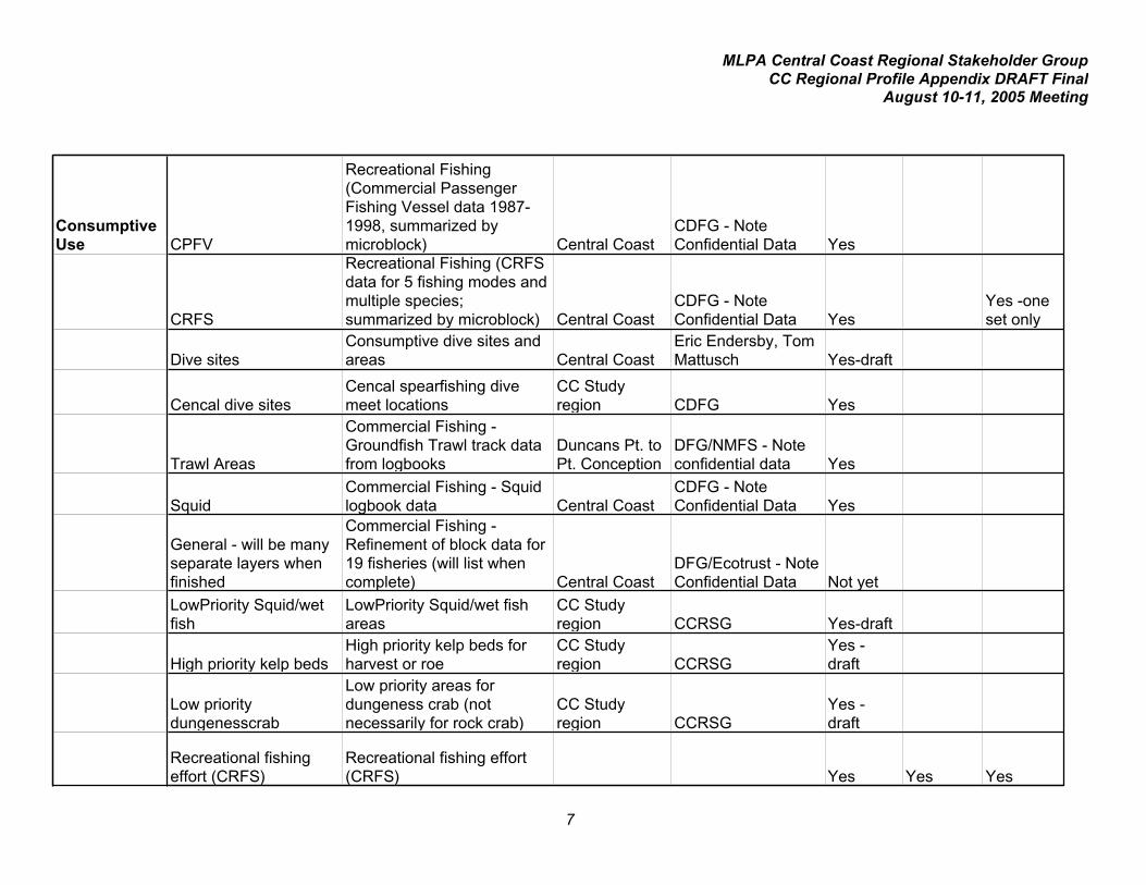
7
Consumptive Use CPFV
Recreational Fishing (Commercial Passenger Fishing Vessel data 1987-1998, summarized by microblock) Central Coast
CDFG - Note Confidential Data Yes
CRFS
Recreational Fishing (CRFS data for 5 fishing modes and multiple species; summarized by microblock) Central Coast
CDFG - Note Confidential Data Yes
Yes -one set only
Dive sitesConsumptive dive sites and areas Central Coast
Eric Endersby, Tom Mattusch Yes-draft
Cencal dive sitesCencal spearfishing dive meet locations
CC Study region CDFG Yes
Trawl Areas
Commercial Fishing - Groundfish Trawl track data from logbooks
Duncans Pt. to Pt. Conception
DFG/NMFS - Note confidential data Yes
SquidCommercial Fishing - Squid logbook data Central Coast
CDFG - Note Confidential Data Yes
General - will be many separate layers when finished
Commercial Fishing - Refinement of block data for 19 fisheries (will list when complete) Central Coast
DFG/Ecotrust - Note Confidential Data Not yet
LowPriority Squid/wet fish
LowPriority Squid/wet fish areas
CC Study region CCRSG Yes-draft
High priority kelp bedsHigh priority kelp beds for harvest or roe
CC Study region CCRSG
Yes - draft
Low priority dungenesscrab
Low priority areas for dungeness crab (not necessarily for rock crab)
CC Study region CCRSG
Yes - draft
Recreational fishing effort (CRFS)
Recreational fishing effort (CRFS) Yes Yes Yes

MLPA Central Coast Regional Stakeholder GroupCC Regional Profile Appendix DRAFT Final
August 10-11, 2005 Meeting
8
Non- Consumptive Use Recreational dive sites
Dive sites (note - includes consumptive use sites as not possible to distinguish)
CC study region
Multiple sources - CCRSG members, REEF, Pt. Lobos, etc Yes -draft Yes -draft
Technical dive sites Technical dive sitesCC study region
Multiple sources - CCRSG members, REEF, Pt. Lobos, Yes -draft Yes -draft
Diving areas Dive sitesCC Study region LaFranchi contract
Kayak areas Kayak use areasCC Study region "
Whale watch areas Whale watching areasCC Study region "
Wildlife viewing Wildlife viewing - shore/boatCC Study region "
Tidepooling areas TidepoolingCC Study region "
CulturalShipwrecks of Monterey Bay Shipwrecks of Monterey Bay
CC Study region Yes Yes Yes
Coastal access points Coastal access points Yes Yes Yes
Research / Monitoring Monitoring sites
Scientific Monitoring Sites (PISCO, MARINe, LIMPET, CENCOOS)
CC Study region
various sources (P. Raimondi, J.Engles,)/SIMON Yes
Research/Educational Institutions
Research and educational stations/facilities
CC Study region
various sources; compiled by Bren school students Yes
Scientific Collection areas Scientific collection areas
CC Study region ??? John Pearse?? No
CCAMP Water quality monitoring locations
Central California Ambient Monitoring Program water quality monitoring locations
CC Study region SWQCB Yes

MLPA Central Coast Regional Stakeholder GroupCC Regional Profile Appendix DRAFT Final
August 10-11, 2005 Meeting
9
Management
3nmi Offshore Jurisdicational Boundary
3nmi Offshore Jurisdicational Boundary (state waters boundary) statewide CDFG Yes Yes Yes
CalTrawl BlocksCalTrawl blocks (10minute grid) statewide CDFG Yes
Cal Trawl Microblocks
CalTrawl microblocks (1 minute grid for fishery catch data records) statewide CDFG Yes
State MPAsExisting state MPAs; Feb. 2005 version statewide CDFG Yes Yes
Central California National Marine Sanctuary boundaries
Central California National Marine Sanctuary boundaries statewide MBNMS Yes Yes
Non-trawl Rockfish closure areas (north, south, central)
Non-trawl Rockfish closure areas (north, south, central) statewide CDFG Yes Yes
Trawl Rockfish closure areas (north, central, south)
Trawl Rockfish closure areas (north, central, south) statewide CDFG Yes Yes YesRec. Groundfish
Fulltime Closures - 2005
Rec. Groundfish Fulltime Closures - 2005 statewide CDFG Yes Yes Yes
Exclusive economic zone (EEZ - federal waters)
Exclusive economic zone (EEZ - federal waters) statewide Yes Yes Yes
Power plant and military hazard areas
Power plant closures, military saftey and hazard zones Central Coast CDFG Yes
Admin kelp beds Administrative kelp beds statewide CDFG Yes Yes Yes
Groundfish EFH - no trawl zones
Groundfish EFH - most recent no trawl zones from PFMC statewide PFMC Yes?

MLPA Central Coast Regional Stakeholder GroupCC Regional Profile Appendix DRAFT Final
August 10-11, 2005 Meeting
10
ASBS
State Areas of Special Biological Significance (ASBS, or water quality protection areas) statewide CDFG/SWQCB Yes
Terrestrial protected areas
Terrestrial protected areas (state parks, state beaches, DOD lands, other state and federal protected areas in coastal watersheds) statewide
Multiple sources; compiled by TNC Yes Yes Yes
NERRsNational Estuarine Research Reserves statewide
USFWS/NERR Program Yes Yes Yes
OtherPollution discharge points
Permitted pollution discharge points statewide SWQCB, 2004 data Yes
Coastal watersheds
Coastal watersheds classified by uban, agriculture, and road density
Pt.Conception to Oregion
TNC from multiple sources Yes
Impaired water bodies
Section 303d impaired water bodies (rivers, shoreline, estuaries, bays and habors) statewide
SWQCB, 2005 TMDL list Yes
Hardened shoreline Marinas/seawalls/riprap statewide
NOAA-Environmental Sensitivity Index Yes
?wrong name
ESI for northern Central California
ESI for northern Central California - has info on human use areas, habitat areas, shoreline, etc statewide Yes Yes
MLPA Central Coast Regional Stakeholder GroupCC Regional Profile Appendix DRAFT Final
August 10-11, 2005 Meeting
11
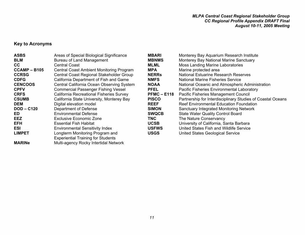
Key to Acronyms
ASBS Areas of Special Biological Significance MBARI Monterey Bay Aquarium Research InstituteBLM Bureau of Land Management MBNMS Monterey Bay National Marine SanctuaryCC Central Coast MLML Moss Landing Marine LaboratoriesCCAMP – B105 Central Coast Ambient Monitoring Program MPA Marine protected areaCCRSG Central Coast Regional Stakeholder Group NERRs National Estuarine Research ReservesCDFG California Department of Fish and Game NMFS National Marine Fisheries ServiceCENCOOS Central California Ocean Observing System NOAA National Oceanic and Atmospheric AdministrationCPFV Commercial Passenger Fishing Vessel PFEL Pacific Fisheries Environmental LaboratoryCRFS California Recreational Fisheries Survey PFMC – E118 Pacific Fisheries Management CouncilCSUMB California State University, Monterey Bay PISCO Partnership for Interdisciplinary Studies of Coastal OceansDEM Digital elevation model REEF Reef Environmental Education FoundationDOD – C120 Department of Defense SIMON Sanctuary Integrated Monitoring NetworkED Environmental Defense SWQCB State Water Quality Control BoardEEZ Exclusive Economic Zone TNC The Nature ConservancyEFH Essential Fish Habitat UCSB University of California, Santa BarbaraESI Environmental Sensitivity Index USFWS United States Fish and Wildlife ServiceLIMPET Longterm Monitoring Program and
Experiential Training for StudentsUSGS United States Geological Service
MARINe Multi-agency Rocky Intertidal Network

MLPA Central Coast Regional Stakeholder GroupCC Regional Profile Appendix DRAFT Final
August 10-11, 2005 Meeting
12
2 (a): List of Fishes Likely to Benefit from the Establishment of Marine Protected Areas in Central California
Species
Primarydepthrangein feet (x0.305=meters)
Primarygeographicrangewithin stateusing fourregions
Habitatpreferencejuveniles
Habitatpreferenceadults
Unique orsignificantlife-historycharacteristics
Larvaltype
Larvalduration[potentiallarvaldispersal]
Potentialfor adultdispersal
Butterfish(Pacificpompano)
30-300 All coastalpelagic
coastal pelagic a schooling species; planktonic unknown moderate
Cabezon 0-250 All regions,includingislands
rocky reefs,break-waters, kelpbeds, tidepools, openocean
rocky reefs,kelp beds
eggs adhesive,attach to substrate,often macroalgae
planktonic 3-4months
low
Croaker, white 0-420 All; mostcommonPoint Reyesto Mexicoborder
near bottomin shallow softhabitat
soft bottom,primarilynearshore andestuaries
schooling; multiplespawning each year;adults in deeperwater than juveniles
planktonic
larvaebecomeepibenthic
short low
Eel, wolf- Intertidalto 600
N, NC, SC pelagic rocky reefs,kelp beds
not a true eel; spawnOct.-February
planktonic?
1-2months
moderate
Flounder,starry
Shallow -900
N,NC,SC estuaries andbays,nearshoresoft bottom
soft bottom;estuaries andbays to upperslope
spawn near rivermouths and estuariesand bay
planktonic 25-75days
moderate
Greenling,kelp
0-150 N,NC,SC rocky reefs,kelp beds
rocky reefs,kelp beds
eggs adhere to rockysubstrate
planktonic unknown moderate
Greenling,rock
shallow N,NC rocky reefs,kelp beds
rocky reefs,kelp beds
eggs adhere to rockysubstrate
planktonic unknown moderate

MLPA Central Coast Regional Stakeholder GroupCC Regional Profile Appendix DRAFT Final
August 10-11, 2005 Meeting
13
Species
Primarydepthrange
Primarygeographicrange
Habitatpreferencejuveniles
Habitatpreferenceadults
Unique/significantLife-historycharacteristics
Larvaltype
Larvalduration
Potentialfor adultdispersal
Grunion,California
0-60 SC,S sandynearshoreareas
sandynearshoreareas
eggs deposited onsandy beaches; lackfilaments
planktonic low tomoderate
moderate
Guitarfish,shovelnose
0-50 SC,S as adults shallow sand,mud, opencoast, bays,and estuaries
live-bearing benthic none moderate
Hagfish,Pacific
30-3096 All ? soft bottom deposit egg cases ? unknown moderate
Halibut,California
0-300 All estuaries,shallow opencoast softbottom
estuaries andsoft bottomopen coast
distributioninfluenced by El Niñoevents
planktonic < 30 days moderate
Jacksmelt shallow All kelp and eelgrass beds;sandybeaches;harbors
kelp and eelgrass beds;sandy beaches;harbors
eggs with filamentsfor attachment to eelgrass and shallowalgal beds
planktonic low moderate
Lingcod 0-1400 All rocky reefs,kelp beds,hard bottom,soft bottom
rocky reefs,kelp beds, hardbottom, softbottom
Spawns nearshoreon rocky reefs; malesguard eggs
planktonic 3 months high
Lizardfish,California
5-750 SC,S primarily softbottom
primarily softbottom
rest on bottom usingpelvic fins
planktonic unknown moderate
Midshipman,plainfin
0-1000 All soft bottom soft bottom;spawn on hardsubstrate
Eggs deposited onrocks and hardsubstrate
planktonic unknown moderate
Opaleye 0-95 SC,S rockyintertidal
rocky reefs,kelp beds
regulates kelp growthby grazing
planktonic unknown moderate
Prickleback,monkeyface
0-80 N,NC,SC rockyintertidal
rocky reefs,kelp beds
deposit eggs onrocky substrate
planktonic low low

MLPA Central Coast Regional Stakeholder GroupCC Regional Profile Appendix DRAFT Final
August 10-11, 2005 Meeting
14
Species
Primarydepthrange
Primarygeographicrange
Habitatpreferencejuveniles
Habitatpreferenceadults
Unique/significantLife-historycharacteristics
Larvaltype
Larvalduration
Potentialfor adultdispersal
Prickleback,rock
0-60 N,NC,SC rockyintertidal
rocky reefs,shallow
deposit eggs onrocky substrate
planktonic low low
Queenfish 0-180 SC,S soft bottom shallow waterand sandybottom; in baysand sloughs
spawn at night fromMarch to September
planktonic short moderate
Ray, bat 0-150 All shallow softbottom; baysand estuaries
shallow sandyand rockyareas, includingbays andestuaries; kelpbeds
live-bearing miniatureadults
none moderate
Rockfish,aurora
600-1800 All soft bottom hard and softbottom
live-bearing planktonic moderate moderate
Rockfish, bank 102-810 All midwater midwater overhard bottom,drop offs
live-bearing planktonic moderate moderate
Rockfish,black
0-1200 N,NC,SC soft bottom rocky reefs,kelp forests
live-bearing planktonic moderte moderate
Rockfish,black-and-yellow
0-120 NC,SC,S shallow rockyreefs
shallow rockyreefs, kelpforests
live-bearing planktonic Low tomoderate
low
Rockfish,blackgill
720-1800(juv. <660)
All soft bottom hard bottom,soft bottom,canyons, steepdrop offs
live-bearing planktonic moderate moderate
Rockfish, blue 0-300 All rocky reefs,kelp forests,soft bottom
rocky reefs,kelp forests
live-bearing planktonic moderate moderate

MLPA Central Coast Regional Stakeholder GroupCC Regional Profile Appendix DRAFT Final
August 10-11, 2005 Meeting
15
Species
Primarydepthrange
Primarygeographicrange
Habitatpreferencejuveniles
Habitatpreferenceadults
Unique/significantLife-historycharacteristics
Larvaltype
Larvalduration
Potentialfor adultdispersal
Bocaccio 0-1050 All over hard andsoft bottom
midwater overhard bottom
live-bearing planktonic moderate moderate
Rockfish,brown
0-420 All low-relief hardand softbottom
low-relief hardand soft bottom
live-bearing planktonic low tomoderate
low
Rockfish,calico
60-840 SC,S soft bottom hard bottom,sand-rock andmud-rockinterface
live-bearing planktonic moderate low
Rockfish,canary
0-900 N,NC,SC soft bottom;sand-rockinterface
midwater andnear bottomover hardbottom
live-bearing planktonic moderate moderateto high
Chilipepper 0-1080 All soft bottom midwater overhard bottom
live-bearing planktonic moderate moderate
Rockfish,China
36-420 N,NC,SC rocky reefs rocky reefs,kelp forests
live-bearing planktonic low tomoderate
low
Rockfish,copper
0-600 All rocky reefsand softbottom
rocky reefs,kelp forests
live-bearing planktonic moderate low
Cowcod 68-1200 All soft and hardbottom
hard bottom,canyons
live-bearing planktonic moderate low
Rockfish,darkblotched
240-1800 All soft bottom soft and hardbottom
live-bearing planktonic moderate moderate
Rockfish, flag 100-600 SC,S rocky reefs rocky reefs,canyons
live-bearing planktonic Moderate low
Rockfish,gopher
0-180 NC,SC,S rocky reefs rocky reefs,kelp forests
live-bearing planktonic low tomoderate
low

MLPA Central Coast Regional Stakeholder GroupCC Regional Profile Appendix DRAFT Final
August 10-11, 2005 Meeting
16
Species
Primarydepthrange
Primarygeographicrange
Habitatpreferencejuveniles
Habitatpreferenceadults
Unique/significantLife-historycharacteristics
Larvaltype
Larvalduration
Potentialfor adultdispersal
Rockfish,grass
0-150 All shallow rockyreefs
shallow rockyreefs, kelpforests
live-bearing planktonic moderate low
Rockfish,greenblotched
200-1300 SC,S soft bottom hard and softbottom,canyons
live-bearing planktonic moderate low
Rockfish,greenstriped
200-1320 All soft bottom low relief hardbottom, softbottom
live-bearing planktonic moderate moderate
Rockfish,greenspotted
160-660 NC,SC,S soft bottom hard bottom,canyons
live-bearing planktonic moderate low
Rockfish,halfbanded
192-1320 SC,S soft bottom low relief hardand soft bottom,cobble
live-bearing planktonic moderate moderate
Rockfish, kelp 0-150 NC,SC,S kelp forestsand rockyreefs
kelp forests live-bearing planktonic moderate low
Rockfish,Olive
0-480 NC,SC,S kelp forests,soft bottom
rocky reefs,kelp forests
live-bearing planktonic moderate low
Pacific oceanperch
180-2100 All midwater overhard bottom
midwater overhard bottom
live-bearing planktonic moderate moderate
Rockfish, pink 250-1200 NC,SC,S soft bottom hard bottom,canyons
live-bearing planktonic moderate low
Rockfish,pinkrose
325-960 SC,S soft bottom hard bottom,canyons
live-bearing planktonic moderate low
Rockfish,quillback
75-900 N,NC rocky reefs rocky reefs live-bearing planktonic moderate low
Rockfish,redbanded
300-1560 All soft bottom soft and hardbottom
live-bearing planktonic moderate low
Rockfish,redstripe
300-1200 N,NC hard bottom hard bottom live-bearing planktonic moderate moderate

MLPA Central Coast Regional Stakeholder GroupCC Regional Profile Appendix DRAFT Final
August 10-11, 2005 Meeting
17
Species
Primarydepthrange
Primarygeographicrange
Habitatpreferencejuveniles
Habitatpreferenceadults
Unique/significantLife-historycharacteristics
Larvaltype
Larvalduration
Potentialfor adultdispersal
Rockfish,rosethorn
390-1800 N,NC,SC soft and hardbottom
hard bottom,canyons
live-bearing planktonic moderate low
Rockfish, rosy 50-420 All soft and hardbottom
hard bottom live-bearing planktonic moderate low
Rockfish,sharpchin
300-1050 All hard bottom hard bottom live-bearing planktonic moderate moderate
Rockfish,shortbelly
0-930 All midwater overhard bottom
midwater overhard bottom
live-bearing planktonic moderate moderate
Rockfish,speckled
100-1200 All hard bottom hard bottom live-bearing planktonic moderate moderate
Rockfish,splitnose
700-1560 All soft bottom hard bottom,canyons
live-bearing planktonic moderate moderate
Rockfish,squarespot
60-600 All hard bottom hard bottom live-bearing planktonic moderate moderate
Rockfish,starry
80-900 NC,SC,S hard bottom hard bottom live-bearing planktonic moderate low
Rockfish,stripetail
192-1320 All soft bottom soft and hardbottom
live-bearing planktonic moderate moderate
Rockfish,swordspine
250-1420 NC,SC,S soft bottom hard bottom,canyons
live-bearing planktonic moderate low
Rockfish, tiger 200-900 N,NC hard bottom hard bottom live-bearing planktonic moderate low
Rockfish,treefish
0-150 SC,S rocky reefs rocky reefs,kelp forests
live-bearing planktonic moderate low
Rockfish,vermilion
0-900 All soft and hardbottom
wide depthrange, rockyreefs, kelpforests,canyons
live-bearing planktonic moderate low
Rockfish,widow
0-1200 All midwater overhard bottom
midwater overhard bottom
live-bearing planktonic moderate moderate

MLPA Central Coast Regional Stakeholder GroupCC Regional Profile Appendix DRAFT Final
August 10-11, 2005 Meeting
18
Species
Primarydepthrange
Primarygeographicrange
Habitatpreferencejuveniles
Habitatpreferenceadults
Unique/significantLife-historycharacteristics
Larvaltype
Larvalduration
Potentialfor adultdispersal
Rockfish,yelloweye
150-1200 N,NC,SC rocky reefs hard bottom,canyons
live-bearing planktonic moderate low
Rockfish,yellowtail
0-1800 All midwater midwater overhard bottom
live-bearing planktonic moderate moderate
Sanddab,Pacific
30-1800 All soft bottom soft bottom may spawn twice ayear
planktonic unknown moderate
Seabass, white 0-400 NC,SC,Soccursfarther northduring ElNiño events
sandy area,estuaries,piers, jetties,kelp beds
kelp beds.Rocky reefs,offshore banks,open ocean
adults aggregate inspring-summerduring spawning
planktonic high
Shark, brownsmoothhound
0-360 All bays andestuaries
soft bottom,bays andestuaries,nearshore
live-bearing miniatureadults
zero moderate
Shark, graysmoothhound
0-150 All bays andestuaries
soft bottom,bays andestuaries,nearshore
live-bearing miniatureadults
zero moderate
Shark, horn 0-492 S rocky reefs,kelp beds
rocky reefs,kelp beds
lay egg cases miniatureadults
zero moderate
Shark, Pacificangel
3-600 SC,S flat, sandybottoms;
flat, sandybottoms; sandchannelsbetween reefs
live-bearing miniatureadults
zero moderate
Shark, leopard 0-300 All enclosedbays andsloughs;kelp beds;shallow sandyareas
enclosed baysand sloughs;kelp beds;shallow sandyareas nearreefs
aggregate in veryshallow water torelease young; live-bearing
miniatureadults
zero moderate
MLPA Central Coast Regional Stakeholder GroupCC Regional Profile Appendix DRAFT Final
August 10-11, 2005 Meeting
19
Species
Primarydepthrange
Primarygeographicrange
Habitatpreferencejuveniles
Habitatpreferenceadults
Unique/significantLife-historycharacteristics
Larvaltype
Larvalduration
Potentialfor adultdispersal
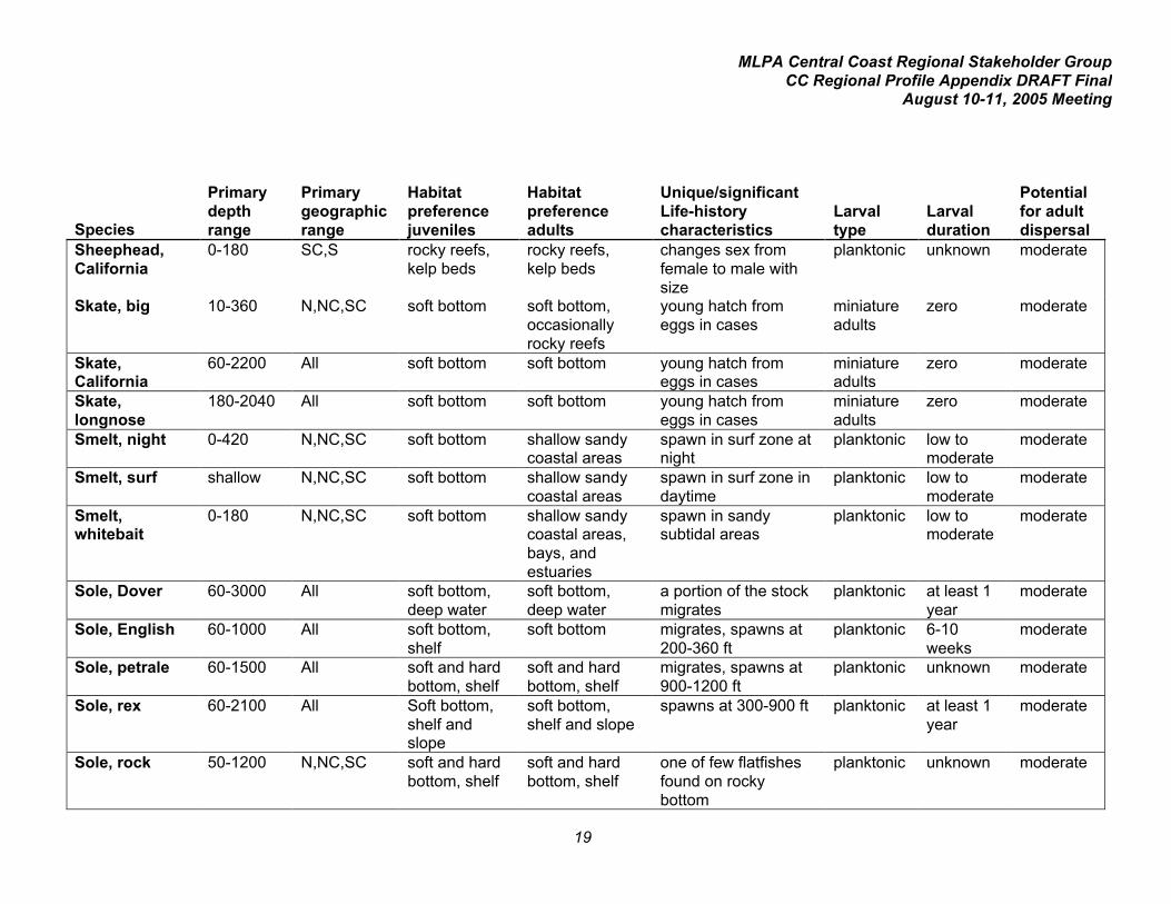
Sheephead,California
0-180 SC,S rocky reefs,kelp beds
rocky reefs,kelp beds
changes sex fromfemale to male withsize
planktonic unknown moderate
Skate, big 10-360 N,NC,SC soft bottom soft bottom,occasionallyrocky reefs
young hatch fromeggs in cases
miniatureadults
zero moderate
Skate,California
60-2200 All soft bottom soft bottom young hatch fromeggs in cases
miniatureadults
zero moderate
Skate,longnose
180-2040 All soft bottom soft bottom young hatch fromeggs in cases
miniatureadults
zero moderate
Smelt, night 0-420 N,NC,SC soft bottom shallow sandycoastal areas
spawn in surf zone atnight
planktonic low tomoderate
moderate
Smelt, surf shallow N,NC,SC soft bottom shallow sandycoastal areas
spawn in surf zone indaytime
planktonic low tomoderate
moderate
Smelt,whitebait
0-180 N,NC,SC soft bottom shallow sandycoastal areas,bays, andestuaries
spawn in sandysubtidal areas
planktonic low tomoderate
moderate
Sole, Dover 60-3000 All soft bottom,deep water
soft bottom,deep water
a portion of the stockmigrates
planktonic at least 1year
moderate
Sole, English 60-1000 All soft bottom,shelf
soft bottom migrates, spawns at200-360 ft
planktonic 6-10weeks
moderate
Sole, petrale 60-1500 All soft and hardbottom, shelf
soft and hardbottom, shelf
migrates, spawns at900-1200 ft
planktonic unknown moderate
Sole, rex 60-2100 All Soft bottom,shelf andslope
soft bottom,shelf and slope
spawns at 300-900 ft planktonic at least 1year
moderate
Sole, rock 50-1200 N,NC,SC soft and hardbottom, shelf
soft and hardbottom, shelf
one of few flatfishesfound on rockybottom
planktonic unknown moderate

MLPA Central Coast Regional Stakeholder GroupCC Regional Profile Appendix DRAFT Final
August 10-11, 2005 Meeting
20
Species
Primarydepthrange
Primarygeographicrange
Habitatpreferencejuveniles
Habitatpreferenceadults
Unique/significantLife-historycharacteristics
Larvaltype
Larvalduration
Potentialfor adultdispersal
Sole, sand 5-312 N,NC,SC Soft bottom,nearshore,estuaries
soft bottom,nearshore
one of few medium-large flatfish foundinshore
planktonic unknown moderate
Sole, slender 250-1700 All soft bottom,shelf andslope
soft bottom,shelf and slope
relatively abundantoffshore species
planktonic moderate moderate
Surfperch,barred
0-240 NC,SC,S beaches beaches bear live, free-swimming young
notapplicable
not applic-able
moderate
Surfperch,black
0-130 All rocky reef,kelp beds
rocky reef, kelpbeds
bear live, free-swimming young
notapplicable
not applic-able
moderate
Surfperch,calico
0-30 All beaches beaches bear live, free-swimming young
notapplicable
not applic-able
moderate
Surfperch, pile 0-240 All rocky reefs,kelp beds,soft bottom
rocky reefs,kelp beds, softbottom
bear live, free-swimming young
notapplicable
not applic-able
moderate
Surfperch,rainbow
0-130 All rocky reef,kelp beds
rocky reef, kelpbeds
bear live, free-swimming young
notapplicable
not applic-able
moderate
Surfperch,redtail
0-60 N,NC beaches beaches bear live,free-swimming young
notapplicable
not applic-able
moderate
Surfperch,rubberlip
0-150 All rocky reefs,kelp beds,soft bottom
rocky reefs,kelp beds, softbottom
bear live, free-swimming young
notapplicable
not applic-able
moderate
Surfperch,shiner
0-480 All estuaries,soft bottom,kelp beds,rocky reef
estuaries,soft bottom,kelp beds,rocky reef
bear live, free-swimming young
notapplicable
not applic-able
moderateto high(?)
Surfperch,striped
0-55 All rocky reef,kelp beds
rocky reef, kelpbeds
bear live, free-swimming young
notapplicable
not applic-able
moderate
Surfperch,walleye
0-60 All beaches beaches bear live, free-swimming young
notapplicable
not applic-able
moderate

MLPA Central Coast Regional Stakeholder GroupCC Regional Profile Appendix DRAFT Final
August 10-11, 2005 Meeting
21
Species
Primarydepthrange
Primarygeographicrange
Habitatpreferencejuveniles
Habitatpreferenceadults
Unique/significantLife-historycharacteristics
Larvaltype
Larvalduration
Potentialfor adultdispersal
Surfperch,white
0-140 All rocky reefs,kelp beds,soft bottom
rocky reefs,kelp beds, softbottom
bear live, free-swimming young
notapplicable
not applic-able
moderate
Thornyhead,longspine
1090-5000
All deep hardand softbottom
deep hard andsoft bottom;slope
lack swim bladder;may survive afterbeing brought tosurface and released;spawn gelatinousfloating egg masses
planktonic unknown moderateto high
Thornyhead,shortspine
84-5000+ All deep hardand softbottom
deep hard andsoft bottom;slope
lack swim bladder;may survive afterbeing brought tosurface and released;spawn gelatinousfloating egg masses
planktonic unknown moderateto high
Tomcod,Pacific
0-720 N,NC,SC unknown soft bottom broadcast spawners;high fecundity
planktonic unknown moderate
Topsmelt shallow All kelp and eelgrass beds;sandybeaches,harbors
kelp and eelgrass beds;sandy beaches,harbors
spawns in eel grassand algal beds,possibly kelp beds;eggs attach tospawning substrateby adhesive filaments
planktonic low moderate
Turbot, C-O shallow-966
All rocky reef,sand; shelf
rocky reef,sand; shelf
one of few flatfishesto occur in kelp beds
planktonic unknown moderate
Turbot, curlfin 25-1146 All soft bottom soft bottom;shelf
small mouth; difficultto catch with hook-and-line
planktonic unknown moderate
Whitefish,ocean
0-300 SC,S unknown midwater overhard and softbottom
responds favorably toEl Niño conditions
planktonic unknown moderate
MLPA Central Coast Regional Stakeholder GroupCC Regional Profile Appendix DRAFT Final
August 10-11, 2005 Meeting
22
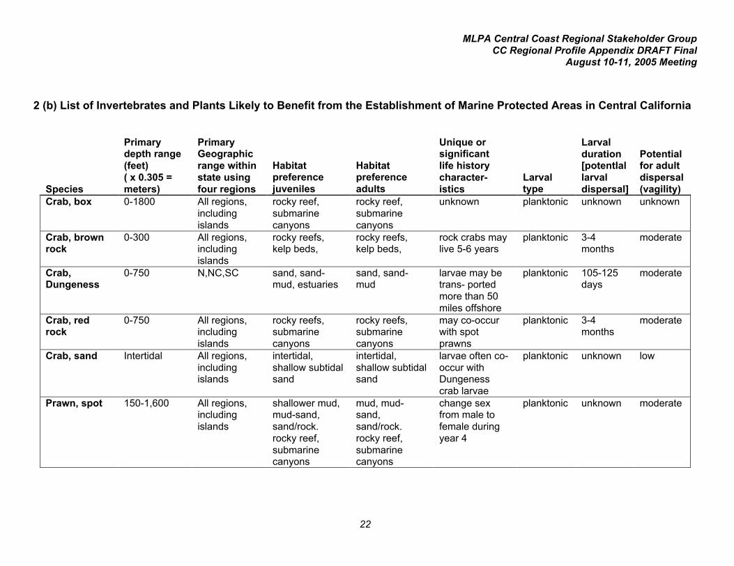
2 (b) List of Invertebrates and Plants Likely to Benefit from the Establishment of Marine Protected Areas in Central California
Species
Primarydepth range(feet)( x 0.305 =meters)
PrimaryGeographicrange withinstate usingfour regions
Habitatpreferencejuveniles
Habitatpreferenceadults
Unique orsignificantlife historycharacter-istics
Larvaltype
Larvalduration[potentIallarvaldispersal]
Potentialfor adultdispersal(vagility)
Crab, box 0-1800 All regions,includingislands
rocky reef,submarinecanyons
rocky reef,submarinecanyons
unknown planktonic unknown unknown
Crab, brownrock
0-300 All regions,includingislands
rocky reefs,kelp beds,
rocky reefs,kelp beds,
rock crabs maylive 5-6 years
planktonic 3-4months
moderate
Crab,Dungeness
0-750 N,NC,SC sand, sand-mud, estuaries
sand, sand-mud
larvae may betrans- portedmore than 50miles offshore
planktonic 105-125days
moderate
Crab, redrock
0-750 All regions,includingislands
rocky reefs,submarinecanyons
rocky reefs,submarinecanyons
may co-occurwith spotprawns
planktonic 3-4months
moderate
Crab, sand Intertidal All regions,includingislands
intertidal,shallow subtidalsand
intertidal,shallow subtidalsand
larvae often co-occur withDungenesscrab larvae
planktonic unknown low
Prawn, spot 150-1,600 All regions,includingislands
shallower mud,mud-sand,sand/rock.rocky reef,submarinecanyons
mud, mud-sand,sand/rock.rocky reef,submarinecanyons
change sexfrom male tofemale duringyear 4
planktonic unknown moderate

MLPA Central Coast Regional Stakeholder GroupCC Regional Profile Appendix DRAFT Final
August 10-11, 2005 Meeting
23
SpeciesPrimarydepth range
PrimaryGeographicrange
Habitatpreferencejuveniles
Habitatpreferenceadults
Life historycharacteristics
Larvaltype
Larvalduration
Potentialfor adultdispersal
Shrimp,ghost andmud shrimp(severalspecies)
Intertidal All regions sand,sand/mud,sand/gravel
sand,sand/mud,sand/gravel
form permanentburrows orimperma-nenttunnels
planktonic unknown low
Shrimp,ocean
150-1200 N,NC,SC:Oregonborder to Pt.Arguello
green mud,mud-sand
green mud,mud-sand
change sexfrom male tofemale duringyear 2
planktonic 2.5 to 3months
moderate
Urchin,purple
0-300 All regions,includingislands
rocky reefs,kelp beds,under canopyof adults
rocky reefs,kelp beds
require highdensities forsuccessfulspawning
planktonic 6-8 weeks low
Urchin, red Intertidal to500
All regions,includingislands
rocky reefs,kelp beds,under canopyof adults
rocky reefs,kelp beds
require highdensities forsuccessfulspawning
planktonic 6-8 weeks low
Abalone,black
Intertidal,0-20
NC,SC,S crevices inrocky reefs,kelp beds
rocky reefs,kelp beds
susceptible towitheringsyndromedisease
planktonic 4-7 days low
Abalone, flat 20-70 All regions,includingislands
crevices inrocky reefs,kelp beds
rocky reefs,kelp beds
generally acryptic species
planktonic 4-7 days low
Abalone,pinto
Intertidal to70
N,NC,SC crevices inrocky reefs,kelp beds
rocky reefs,kelp beds
commonlyfound atapprox. 4-inchlength
planktonic 4-7 days low

MLPA Central Coast Regional Stakeholder GroupCC Regional Profile Appendix DRAFT Final
August 10-11, 2005 Meeting
24
SpeciesPrimarydepth range
PrimaryGeographicrange
Habitatpreferencejuveniles
Habitatpreferenceadults
Life historycharacteristics
Larvaltype
Larvalduration
Potentialfor adultdispersal
Abalone, red Intertidal to100
All regions,includingislands
crevices inrocky reefs,kelp beds,boulderoutcrops, undercanopy of redurchins
rocky reefs,kelp beds,boulderoutcrops
largest abalonespecies in theworld
planktonic 4-7 days low
Clam,Californiajackknife
Intertidal to South,mainland andislands
sandy mud,estuaries
sandy mud,estuaries
occupies apermanentburrow
planktonic unknown low
Clam, chione(severalspecies)
Intertidal to165
South,mainland andislands
mud, sand,estuaries
mud, sand,estuaries
smooth chionesubject tohabitat loss dueto harbordevelop-ment
planktonic unknown low
Clam,littleneck(severalspecies)
Intertidal All regions,includingislands
cobble beds cobble beds prized fooditem
planktonic unknown low
Clam, gaper(severalspecies)
Intertidal to150
All regions sand,sand/mud,estuaries
sand,sand/mud,estuaries
may live to 17years
planktonic low
Clam,geoduck
0-360 All regions sand/mud,estuaries
sand/mud,estuaries
individuals mayexceed 10pounds
planktonic 2 weeks low
Clam, Manila Intertidal All regions sand/mud,estuaries
sand/mud,estuaries
introduced fromJapan;importantrecreationalspecies
planktonic 3 weeks low
MLPA Central Coast Regional Stakeholder GroupCC Regional Profile Appendix DRAFT Final
August 10-11, 2005 Meeting
25
SpeciesPrimarydepth range
PrimaryGeographicrange
Habitatpreferencejuveniles
Habitatpreferenceadults
Life historycharacteristics
Larvaltype
Larvalduration
Potentialfor adultdispersal
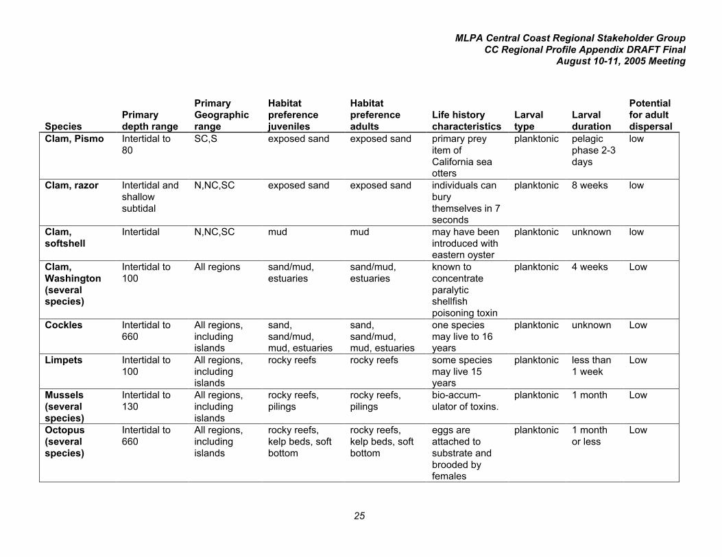
Clam, Pismo Intertidal to80
SC,S exposed sand exposed sand primary preyitem ofCalifornia seaotters
planktonic pelagicphase 2-3days
low
Clam, razor Intertidal andshallowsubtidal
N,NC,SC exposed sand exposed sand individuals canburythemselves in 7seconds
planktonic 8 weeks low
Clam,softshell
Intertidal N,NC,SC mud mud may have beenintroduced witheastern oyster
planktonic unknown low
Clam,Washington(severalspecies)
Intertidal to100
All regions sand/mud,estuaries
sand/mud,estuaries
known toconcentrateparalyticshellfishpoisoning toxin
planktonic 4 weeks Low
Cockles Intertidal to660
All regions,includingislands
sand,sand/mud,mud, estuaries
sand,sand/mud,mud, estuaries
one speciesmay live to 16years
planktonic unknown Low
Limpets Intertidal to100
All regions,includingislands
rocky reefs rocky reefs some speciesmay live 15years
planktonic less than1 week
Low
Mussels(severalspecies)
Intertidal to130
All regions,includingislands
rocky reefs,pilings
rocky reefs,pilings
bio-accum-ulator of toxins.
planktonic 1 month Low
Octopus(severalspecies)
Intertidal to660
All regions,includingislands
rocky reefs,kelp beds, softbottom
rocky reefs,kelp beds, softbottom
eggs areattached tosubstrate andbrooded byfemales
planktonic 1 monthor less
Low
MLPA Central Coast Regional Stakeholder GroupCC Regional Profile Appendix DRAFT Final
August 10-11, 2005 Meeting
26
SpeciesPrimarydepth range
PrimaryGeographicrange
Habitatpreferencejuveniles
Habitatpreferenceadults
Life historycharacteristics
Larvaltype
Larvalduration
Potentialfor adultdispersal
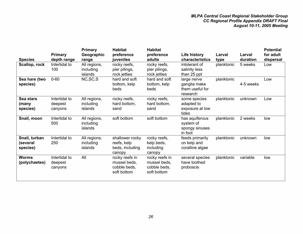
Scallop, rock Intertidal to100
All regions,includingislands
rocky reefs,pier pilings,rock jetties
rocky reefs,pier pilings,rock jetties
intolerant ofsalinity lessthan 25 ppt
planktonic 5 weeks Low
Sea hare (twospecies)
0-60 NC,SC,S hard and softbottom, kelpbeds
hard and softbottom, kelpbeds
large nerveganglia makethem useful forresearch
planktonic4-5 weeks
Low
Sea stars(manyspecies)
Intertidal todeepestcanyons
All regions,includingislands
rocky reefs,hard bottom,sand
rocky reefs,hard bottom,sand
some speciesadapted toexposure at lowtides
planktonic unknown Low
Snail, moon Intertidal to500
All regions,includingislands
soft bottom soft bottom has aquiferoussystem ofspongy sinusesin foot
planktonic 2 weeks low
Snail, turban(severalspecies)
Intertidal to250
All regions,includingislands
shallower rockyreefs, kelpbeds, includingcanopy
rocky reefs,kelp beds,includingcanopy
feeds primarilyon kelp andcoralline algae
planktonic unknown low
Worms(polychaetes)
Intertidal todeepestcanyons
All rocky reefs inmussel beds,cobble beds,soft bottom
rocky reefs inmussel beds,cobble beds,soft bottom
several specieshave toothedproboscis
planktonic variable low

MLPA Central Coast Regional Stakeholder GroupCC Regional Profile Appendix DRAFT Final
August 10-11, 2005 Meeting
27
SpeciesPrimarydepth range
PrimaryGeographicrange
Habitatpreferencejuveniles
Habitatpreferenceadults
Life historycharacteristics
Larvaltype
Larvalduration
Potentialfor adultdispersal
Algae
Gelidium sp.(manyspecies)
Intertidal, to100
All regions,includingislands
rocky reefs rocky reefs may formsmats of algalturf
notapplicable
notapplica-ble
none
Gracilaria sp.(manyspecies)
Intertidal to50
All regions,includingislands
soft bottoms soft bottoms used asspawningsubstrate byherring in SFBay
notapplicable
notapplica-ble
none
Porphyra sp.(manyspecies)
Intertidal to100
All regions,includingislands
rocky reefs rocky reefs may becommon inhigh-energysurf zones
notapplicable
notapplica-ble
none
Sea palm Intertidal N,NC,SC exposed rockyreefs
exposed rockyreefs
individuals canregenerateblades but notstipe.
notapplicable
notapplica-ble
none
Kelp, giant 20-120 NC,SC,S on sand androck substrate
on sand androck substrate
fronds maygrow up to 24inches per day
notapplicable
notapplica-ble
none
Kelp, bull 10-70 N,NC,SC on rock orcobblesubstrate
on rock orcobblesubstrate
found wherewater temp isless than 60 F
notapplicable
notapplica-ble
none

MLPA Central Coast Regional Stakeholder GroupCC Regional Profile Appendix DRAFT Final
August 10-11, 2005 Meeting
28
3. Special Status Species
Mammal Common Name Scientific Name ESA CESA
Blue whale Balaenoptera musculusmusculus
E (06-02-70)
Fin whale Balaenoptera physalus E (06-02-70)
Humpback whale Megaptera novaeangliae E (06-02-70)
North Pacific right whale Eubalaena japonica E (06-02-70)
Gray whale Eschrichtius robustus Delist (06-15-94)
Sei whale Balaenoptera borealis E (06-02-70)
Sperm whale Physeter macrocephalus E (06-02-70)
Killer Whale Orcinus orca PT (12-22-04);SC (NMFS)
Steller sea lion (Easternstock)
Eumetopias jubatus T (04-05-90)
Guadelupe fur seal Arctocephalus townsendi T (12-16-85) T (06-27-71)
Southern sea otter Enhydra lutris nereis T (01-14-77)
Bird Common Name Scientific Name ESA CESACommon loon Gavia immer SSC
Short-tailed Albatross Phoebastria albatrus E (08-30-00) SSC
Black-footed albatross Phoebastria nigripes SC (FWS)
Ashy storm-petrel Oceanodroma homochroa SC (FWS) SSC (SP)
Fork-tailed storm-petrel Oceanodroma furcata SSC (FP)
Black storm-petrel Oceanodroma melania SSC (TP)
California brown pelican Pelecanus occidentaliscalifornicus
E (10-13-70) E (06-27-71)
American white pelican Pelecanus erythrorhynchos SSC (FP)
American bittern Botaurus lentiginosus SC (FWS)
Least bittern Ixobrychius exilis SSC (TP)

MLPA Central Coast Regional Stakeholder GroupCC Regional Profile Appendix DRAFT Final
August 10-11, 2005 Meeting
29
Bird Common Name Scientific Name ESA CESAWhite-faced ibis Plegadis chihi SC (FWS)
Harlequin duck Histrionicus histrionicus SC (FWS) SSC (FP)
California clapper rail Rallus longirostris obsoletus E (10-13-70) E (06-27-71)
California black rail Laterallus jamaicensiscoturniculus
SC (FWS) T (06-27-71)
Western snowy plover Charadrius alexandrinusnivosus
T (04-05-93) SSC
Black oystercatcher Haematopus bachmani SC (FWS)
Whimbrel Numenius phaeopus SC (FWS)
Long-billed curlew Numenius americanus SC (FWS)
Marbled godwit Limosa fedoa SC (FWS)
Black turnstone Arenaria melanocephala SC (FWS)
Red knot Calidris canutus SC (FWS)
Elegant tern Sterna elegans SC (FWS) SSC (TP)
California least tern Sterna antillarum browni E (10-13-70) E (06-27-71)
Marbled murrelet Brachyramphus marmoratusmarmoratus
T (09-30-92) E (03-12-92)
Xantus's murrelet Synthliboramphushypoleucus
SC / Candidate(FWS)
T (12-22-04)
Cassin's auklet Ptychoramphus aleuticus SC (FWS) SSC (SP)
Rhinoceros auklet Cerorhinca monocerata SSC (TP)
Tufted Puffin Fratercula cirrhata SSC (FP)
Reptile Common Name Scientific Name ESA CESALeatherback sea turtle Dermochelys coriacea E (06-02-70)

MLPA Central Coast Regional Stakeholder GroupCC Regional Profile Appendix DRAFT Final
August 10-11, 2005 Meeting
30
Fish Common Name Scientific Name ESA CESAChinook salmon (springrun) Sac Rv and tributaries
Oncorhynchus tshawytscha PT (06-14-04);T (11-15-99)
T (02-05-99)
Chinook salmon (fall/latefall run ) Sacramento river
Oncorhynchus tshawytscha Candidate; SC(NMFS)
SSC
Chinook salmon (winterrun) Sacramento River
Oncorhynchus tshawytscha PT (06-14-04);E (02-03-94)
E (09-22-89)
Coho salmon (central CAcoast ESU)
Oncorhynchus kisutch PE (06-14-04);T (12-02-96)
E (12-31-95)
Steelhead (central CA coastESU) Russian Rv to SoquelCreek
Oncorhynchus mykissirideus
PT (06-14-04):T (10-17-97)
Steelhead (south/cen CAcoast ESU) Pajaro Rv toSanta Maria Rv
Oncorhynchus mykissirideus
PT (06-14-04):T (10-17-97)
Tidewater goby Eucyclogobius newberryi E (02-04-94) SSC (QE)
Pacific lamprey Lampetra tridentata SC (FWS)
White sturgeon Acipenser transmontanus E (09-06-94)
Green sturgeon Acipenser medirostris Candidate; SC(NMFS)
SSC (QT)
Cowcod Sebastes levis SC (NMFS)
Bocaccio Sebastes paucispinis SC (NMFS)
Eulachon Thaleichthys pacificus SSC (WL)
InvertebrateCommon Name Scientific Name ESA CESABlack abalone Haliotis cracherodii SC (NMFS)
Pinto abalone Haliotis kamtschatkana SC (NMFS)

MLPA Central Coast Regional Stakeholder GroupCC Regional Profile Appendix DRAFT Final
August 10-11, 2005 Meeting
31
Index of the listing codes used in the tables above
FEDERAL LISTING CODESESA: Endangered Species Act of 1973 Listing Codes
E Federally listed as EndangeredT Federally listed as ThreatenedPE Proposed for federal listing as EndangeredPT Proposed for federal listing as ThreatenedPD Proposed for federal de-listingCandidate Candidate for federal listing as endangered or threatenedSC Species of Concern
STATE LISTING CODESCESA: California Endangered Species Act Listing Codes
E State-listed as EndangeredT State-listed as ThreatenedCE Candidate for state listing as EndangeredCT Candidate for state listing as ThreatenedSSC Species of Special Concern
QE Qualify as Endangered (fish list)
QT Qualify as Threatened (fish list)
WL Watch List (fish list)
FP First Priority (bird list)
SP Second Priority (bird list)
TP Third Priority (bird list)

I
Appendix II: Profile of Commercial Fishery Summaries for the Central Coast StudyRegion
Contents
1. Summary of Monterey Bay Port Area Fisheries, 1999-20045. Monterey port area landings 1999-20046. Monterey port area ex-vessel values 1999-2004
Fishery Profiles Monterey port area
7. Pelagic wetfish (Sardine/mackerel/anchovy)9. Squid11. Dover sole/thornyhead/sablefish14. Albacore and other tuna16. King salmon (Chinook)18. Other flatfish20. Slope rockfish/grenadier22. Shelf rockfish24. California halibut26. Dungeness crab28. Nearshore rockfish/cabezon/greenling31. Spot prawn33. Swordfish35. Shark37. Jacksmelt38. White seabass40. Lingcod42. Butterfish43. Rock crab45. Summary of Morro Bay Port Area Fisheries, 1999-200447. Morro Bay port area landings 1999-200448. Morro Bay port area ex-vessel values 1999-2004
Fishery Profiles Morro Bay port area
49. Dover sole/thornyhead/sablefish52. Squid54. Albacore and other tuna56. Ocean shrimp58. Slope rockfish/grenadier60. Nearshore rockfish/cabezon/greenling63. Other flatfish65. Swordfish67. King salmon (Chinook)69. Rock crab71. Spot prawn73. Shelf rockfish75. California halibut77. Shark

MLPA Central Coast Regional Stakeholder GroupCC Regional Profile Appendix DRAFT Final
August 10-11, 2005 Meeting
II
78. Lingcod80. Dungeness crab82. Surfperch84. White seabass86. Red urchin

MLPA Central Coast Regional Stakeholder GroupCC Regional Profile Appendix DRAFT Final
August 10-11, 2005 Meeting
1
SUMMARY OF MONTEREY BAY PORT AREA FISHERIES(ranked by average value 1999-2004) = primarily in federal waters
FisherySpeciesTargeted
Number ofFishermenLanding in2003 Primary Gear
Primarydepth
PrimaryHabitat
State orFederalWaters?
2004volume inpounds 2004 value
1999-2004averagevolume inpounds
1999-2004averagevalue
VolumeRank inPort
ValueRankinPort
Marketsquid
marketsquid
55 Seine, brail 5-30fms Sand State 12.2 million $2.9 million 21.1 million $3.5 million 2 1
Salmon King(chinook)
279 troll hook-and-line
surface to50fms
pelagic,openocean
StateandFederal
777k $2.3 million 858k $1.7 million 5 2
Pelagicwetfish
Pacificsardine,northernanchovy,jackmackerel,Pacificmackerel
26 Seine 5-50fms Sand State 34 million -sardines,8.6 million -anchovy,1 million -mackerel
$1.2 millionsardine,$290k -anchovy,$53k -mackerel
26 million -sardines,10 million -anchovy,294kmackerel
$1.1 million- sardines,$328k -anchovy,$20kmackerel
1, 3, 9 3, 8,24
Dover sole/thornyhead/ sablefish
Dover sole,longspinethornyhead,shortspinethornyhea,sablefish
1-46 permitsfor 9 distincttypes of gear-speciescombinations
Bottom trawl,longline(thornyheadsandsablefish), gillnets and traps(sablefish)
150-700fms softbottom,low-reliefmixed andhardbottom
Federal 580k -Dover sole,199k -thornyheads, 509k -sablefish
$197k Doversole,$351kthornyheads,$523ksablefish
927k - Doversole,390k -thornyheads,619k -sablefish
$293kDover sole,$480kthornyheads, $705ksablefish
4, 8, 7 9, 7, 4
Albacore /other tuna
Albacore,also bluefin,bigeye,yellowfin,skipjacktunas
114 troll hook-and-line,purse seine
surface andsubsurfacewaters
openocean,pelagicwaters
Federal 395kalbacore,4k othertuna
$326kalbacore,$11k othertuna
843kalbacore,61k othertuna
$631kalbacore,$103k othertuna
6, 17 5, 15

MLPA Central Coast Regional Stakeholder GroupCC Regional Profile Appendix DRAFT Final
August 10-11, 2005 Meeting
2
FisherySpeciesTargeted
FishermenLanding in2003 Primary Gear
Primarydepth
PrimaryHabitat
State orFederalWaters
2004volume inpounds 2004 value
1999-2004averagevolume
1999-2004averagevalue
VolumeRank
ValueRank
Spot prawntrap
Spot prawn 7 Traps 100-150fms canyon,hard, softand mixedbottom
StateandFederal
48k $520k 54k $511k 18 6
Californiahalibut
Californiahalibut
trawl 34,hook-and-line85
trawl, hook-and-line, gilland trammelnet
2-50fms sand StateandFederal
101k $290k 88k $202k 15 10
Dungenesscrab
Dungesscrab
34 circular traps 0-50fms sand StateandFederal
169k $321k 86k $192k 16 11
Nearshorefinfish
Nearshorerockfish,cabezon,kelpgreenling
58 Hook andline, trap
0-20fms rocky reefs,kelp
State 26k rockfish;13kcabezon,0.8k kelpgreenling
$113krockfish,$63kcabezon,$4,501greenling
41k rockfish,16k cabezon,2k greening
$168krockfish,$67kcabezon,$11kgreenling
20, 26,30
12,19, 27
Otherflatfishes
Pacifcsanddab,Petrale andother soles,and flatfish
28 sanddab,41 otherflatfish
bottom trawl 30-700fms low-reliefsoft bottom
StateandFederal
159ksanddab,232k otherflatfish
$72ksanddab,$209k otherflatfish
278ksanddab,221k otherflatfish
$86ksanddab,$162k otherflatfish
10, 12 18, 13
Swordfish Swordfish 6 drift gill net,hook-and-line,harpoon
surface andnear-surfacewaters
openocean,pelagicwaters
Federal 8k $25k 49k $127k 19 14
Shelfrockfish
24 speciesof shelfrockfish
Hook-and-line53, trawl 22,gill net 1
bottom trawl,midwatertrawl,longline,hook-and-line,gill net
30-200fms deep rockyreefs,cobble andsand,edges ofcanyons
StateandFederal
27k $26k 181k $102k 14 16
MLPA Central Coast Regional Stakeholder GroupCC Regional Profile Appendix DRAFT Final
August 10-11, 2005 Meeting
3
FisherySpeciesTargeted
FishermenLanding in2003 Primary Gear
Primarydepth
PrimaryHabitat
State orFederalWaters
2004volume inpounds 2004 value
1999-2004averagevolume
1999-2004averagevalue
VolumeRank
ValueRank
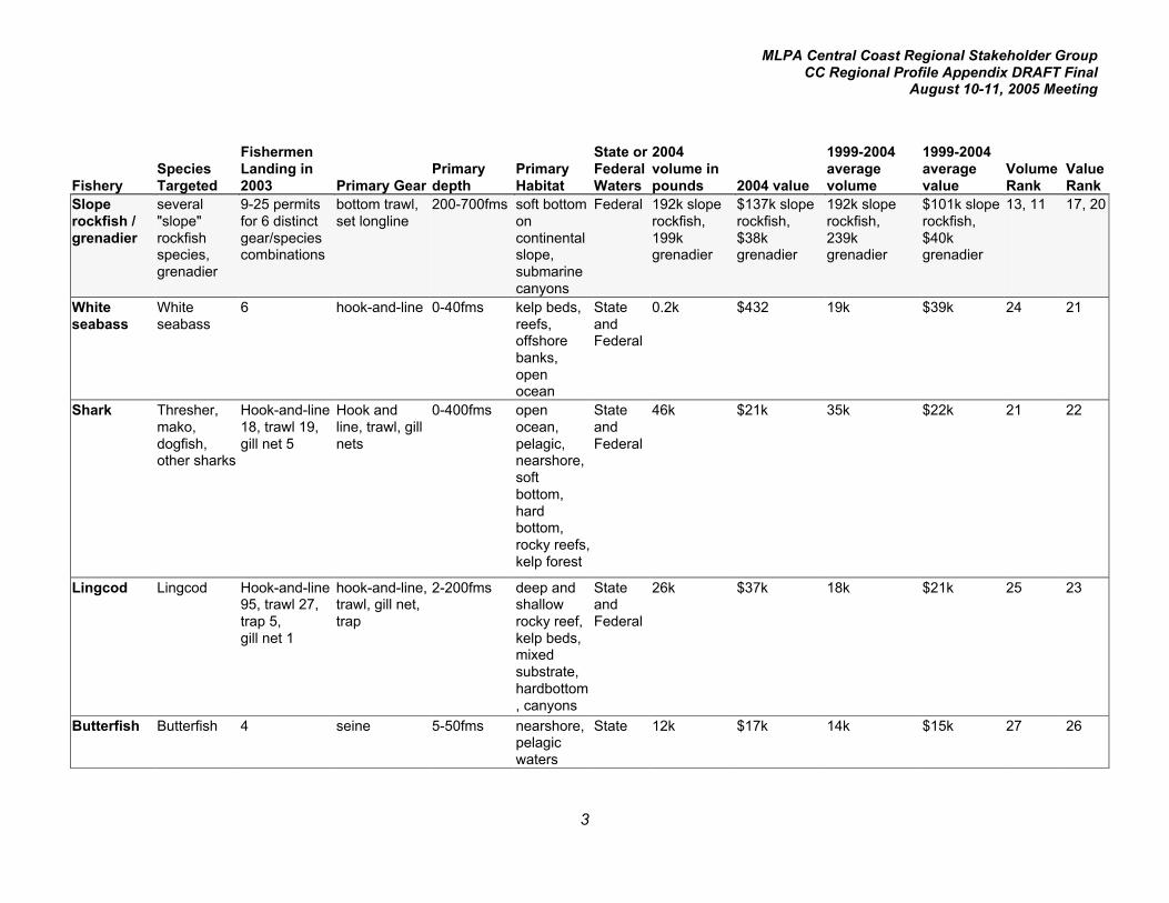
Sloperockfish /grenadier
several"slope"rockfishspecies,grenadier
9-25 permitsfor 6 distinctgear/speciescombinations
bottom trawl,set longline
200-700fms soft bottomoncontinentalslope,submarinecanyons
Federal 192k sloperockfish,199kgrenadier
$137k sloperockfish,$38kgrenadier
192k sloperockfish,239kgrenadier
$101k sloperockfish,$40kgrenadier
13, 11 17, 20
Whiteseabass
Whiteseabass
6 hook-and-line 0-40fms kelp beds,reefs,offshorebanks,openocean
StateandFederal
0.2k $432 19k $39k 24 21
Shark Thresher,mako,dogfish,other sharks
Hook-and-line18, trawl 19,gill net 5
Hook andline, trawl, gillnets
0-400fms openocean,pelagic,nearshore,softbottom,hardbottom,rocky reefs,kelp forest
StateandFederal
46k $21k 35k $22k 21 22
Lingcod Lingcod Hook-and-line95, trawl 27,trap 5,gill net 1
hook-and-line,trawl, gill net,trap
2-200fms deep andshallowrocky reef,kelp beds,mixedsubstrate,hardbottom, canyons
StateandFederal
26k $37k 18k $21k 25 23
Butterfish Butterfish 4 seine 5-50fms nearshore,pelagicwaters
State 12k $17k 14k $15k 27 26
MLPA Central Coast Regional Stakeholder GroupCC Regional Profile Appendix DRAFT Final
August 10-11, 2005 Meeting
4
FisherySpeciesTargeted
FishermenLanding in2003 Primary Gear
Primarydepth
PrimaryHabitat
State orFederalWaters
2004volume inpounds 2004 value
1999-2004averagevolume
1999-2004averagevalue
VolumeRank
ValueRank
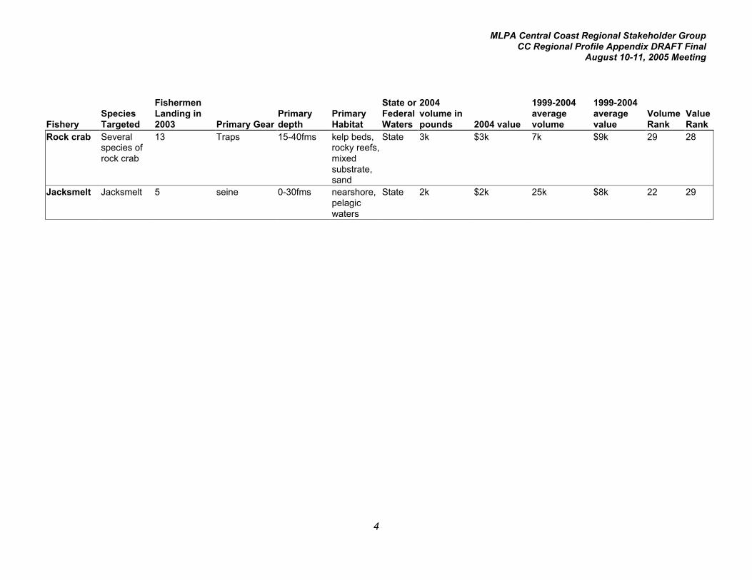
Rock crab Severalspecies ofrock crab
13 Traps 15-40fms kelp beds,rocky reefs,mixedsubstrate,sand
State 3k $3k 7k $9k 29 28
Jacksmelt Jacksmelt 5 seine 0-30fms nearshore,pelagicwaters
State 2k $2k 25k $8k 22 29

MLPA Central Coast Regional Stakeholder GroupCC Regional Profile Appendix DRAFT Final
August 10-11, 2005 Meeting
5
Monterey port area landings (pounds)
Year 1999 2000 2001 2002 2003 20046-year
averageFINFISH (preliminary)Sardine 35,929,390 25,058,931 15,658,063 29,998,833 17,432,494 34,047,042 26,354,126Anchovy 3,291,385 14,494,753 25,706,123 5,992,263 1,555,834 8,577,584 9,936,324Dover sole 1,081,154 1,095,224 924,238 878,152 1,000,780 579,811 926,560King salmon* 1,082,526 1,718,270 381,167 713,242 475,651 777,337 858,032Albacore 1,139,895 757,494 1,366,732 923,384 473,375 394,936 842,636Sablefish 726,326 709,963 570,765 526,019 673,999 508,517 619,265Thornyheads 500,926 464,804 311,631 452,469 409,648 199,283 389,794Mackerel 59,341 196,655 379,415 4,024 48,916 1,079,949 294,717Sanddabs 471,791 98,200 90,765 205,537 640,612 159,143 277,675Grenadier 313,742 222,928 234,592 236,636 225,411 198,568 238,646Other flatfish 333,053 178,468 271,484 174,679 137,479 231,971 221,189Rockfish slope 182,707 157,911 185,753 102,961 333,083 192,430 192,474Rockfish shelf 472,608 291,760 183,785 101,979 10,021 27,369 181,254California halibut 198,817 45,454 45,830 84,135 52,313 100,618 87,861Other tuna 251,949 10,963 97,715 272 3,142 4,460 61,417Swordfish 236,171 29,247 6,521 132 15,242 7,705 49,170Rockfish nearshore 57,993 45,736 51,227 44,652 19,280 26,213 40,850Shark 86,237 34,545 7,036 26,338 10,845 46,142 35,191Jacksmelt 855 9,595 58,460 67,881 8,251 2,190 24,539Rockfish other 105,102 10,328 5,389 2,568 3,487 1,716 21,432White seabass 4,252 24,448 54,692 23,333 7,685 180 19,098Lingcod 27,708 7,700 10,702 20,813 16,792 26,245 18,327Cabezon 23,326 23,851 16,713 13,545 5,827 13,442 16,117Butterfish 307 2,969 8,983 43,008 17,545 12,199 14,169Kelp greenling 4,308 3,433 1,672 1,903 716 821 2,142* From DFG Ocean Salmon Project records
INVERTEBRATESMarket squid 588,960 15,421,113 17,078,248 55,263,371 30,691,176 12,219,049 21,876,986Dungeness crab 25,027 25,691 24,260 107,446 163,020 169,041 85,748Spot prawn 52,980 37,248 48,389 81,880 58,236 47,804 54,423Rock crab 21,136 9,421 2,916 954 2,054 2,787 6,545

MLPA Central Coast Regional Stakeholder GroupCC Regional Profile Appendix DRAFT Final
August 10-11, 2005 Meeting
6
Monterey port area ex-vessel value (dollars)
Year 1999 2000 2001 2002 2003 20046-year
averageFINFISH (preliminary)King salmon* 1,896,701 3,064,105 763,267 1,072,455 859,270 2,258,987 1,652,464Sardine 966,959 968,887 1,434,123 1,289,283 667,100 1,193,567 1,086,653Sablefish 673,935 943,786 699,211 600,037 790,973 523,408 705,225Albacore 772,862 688,292 1,053,981 616,683 327,193 326,099 630,852Thornyheads 582,709 514,856 360,476 528,450 542,808 350,741 480,007Anchovy 219,661 551,252 569,140 255,108 81,964 290,592 327,953Dover sole 311,836 346,658 296,954 285,270 322,641 196,755 293,352California halibut 368,063 101,754 112,062 205,129 133,185 289,563 201,626Rockfish nearshore 189,974 210,636 247,751 168,693 76,898 112,981 167,822Other flatfish 211,816 139,658 193,403 120,198 95,499 209,077 161,609Swordfish 564,682 108,061 19,137 694 41,740 24,880 126,532Other tuna 487,957 10,424 101,253 431 6,351 10,688 102,851Rockfish shelf 218,138 180,404 115,781 60,410 10,686 25,837 101,876Rockfish slope 55,233 109,765 106,253 61,478 172,233 99,060 100,670Sanddabs 126,180 26,159 36,226 62,373 193,431 72,067 86,073Cabezon 77,010 107,954 74,849 50,330 26,656 63,114 66,652Grenadier 44,733 38,348 35,141 37,379 49,000 38,119 40,453White seabass 8,213 46,251 115,716 46,604 15,516 432 38,789Shark 57,344 23,916 7,798 9,619 10,528 20,640 21,641Lingcod 24,659 9,225 12,830 17,696 21,855 37,369 20,606Mackerel 11,707 29,406 18,877 458 6,681 52,691 19,970Rockfish other 72,768 14,914 5,805 1,758 4,248 2,327 16,970Butterfish 563 2,679 15,753 41,243 11,376 16,773 14,731Kelp greenling 17,717 19,293 9,877 9,797 3,884 4,501 10,845Jacksmelt 548 5,909 18,269 15,053 3,068 2,244 7,515*From DFG Ocean Salmon Project records
INVERTEBRATESMarket squid 78,579 1,881,719 1,773,494 6,787,256 7,920,422 2,852,367 3,548,973Spot prawn 374,011 342,491 473,359 768,816 586,299 519,893 510,812Dungeness crab 74,729 78,821 76,009 260,325 341,753 320,610 192,041Rock crab 26,076 12,434 4,406 1,308 5,701 3,294 8,870

MLPA Central Coast Regional Stakeholder GroupCC Regional Profile Appendix DRAFT Final
August 10-11, 2005 Meeting
7
Profile of Major Pelagic Wet Fish Commercial Fisheries in Central Coast Study Region:Monterey Area
Port area: MontereyFishery: Pelagic wet fish
Species targeted: Pacific sardine (Sardinops sagax), northern anchovy (Engraulis mordax), jackmackerel (Trachurus symmetricus), Pacific mackerel (Scomber japonicus)
2004 preliminary landings (pounds): 43,704,575 (check totals)comprised of 34,047,042 lbs sardine, 8,577,584 lbs anchovy, 1,079,949 lbs mackerel2004 preliminary ex-vessel value: $1,536,850comprised of $1,193,567 sardine, $290,592 sardine, $52,691 mackerel
2003 landings: 18,637,244comprised of 17,432,494 lbs sardine, 1,155,834 lbs anchovy, 48,916 lbs mackerel2003 ex-vessel value: $755,745comprised of $ 667,100 sardine, $81,964 anchovy, $6,681 mackerel
1999-2004 average landings: 36,585,167comprised of 26,354,126 sardine, 9,936,324 anchovy, 294,717 mackerel1999-2004 average ex-vessel value: $1,434,576comprised of $1,086,653 sardine, $327,953 anchovy, $19,970 mackerel
Rank of average annual landings in port area 1999-2004:Sardine (1)Anchovy (3)Mackerel (9)
Rank of average annual value in port area 1999-2004:Sardine (3)Anchovy (8)Mackerel (24)
General trend in annual landings 1999-2004:Sardine landings have varied by approximately two-fold, from approximately 16 million to 34 million lbs,with no trend. Anchovy landings have ranged from 1.5 million lbs to more than 25 million lbs with notrend. Mackerel landings have shown extreme variability, ranging from 4,000 lbs to more than 1 millionlbs with no trend.
Comments: The availability of sardines or anchovies is variable and dependent upon watertemperature and the success of the local squid fishery. During good squid seasons, boats will targetsquid only. When squid availability wanes, focus shifts to sardines, usually during the fall. The twomajor pelagic wet fish fleets operating in California are located in Monterey and San Pedro. Harvest ofwet fish may be year round in San Pedro while it is seasonal in Monterey. Pacific mackerel is typicallycaught with sardines in San Pedro while the Monterey fleet rarely lands any, except for warm wateryears.

MLPA Central Coast Regional Stakeholder GroupCC Regional Profile Appendix DRAFT Final
August 10-11, 2005 Meeting
8
Sardines and northern anchovy are important bait, live and frozen, for most game fish. Fish caught forcommercial purposes are generally exported for human consumption, bait, or tuna feed. Some is solddomestically for bait, pet food, and consumption.
Number of fishermen making landings in 2003 and/or 2004 in port area: 26
Primary gear type(s): purse seine, drum seine
Primary depth range: 5-50 fathoms
Primary habitat type(s): sand bottom
Primary area of fishery: State waters__X___ Federal waters_____
Synopsis of regulations applicable to central coast study region:This fishery is federally managed with guidance from the Coastal Pelagic Species Management Plan.The plan dictates methods for stock assessment, quota limits, restricted access, and harvest allocation.The quota for the U.S. Pacific coast is divided into two sub-areas with a September reallocation of theremaining quota. The season for sardine is January 1 through December 31 and the season for Pacificmackerel is July 1 through June 30.
Sardine and mackerel may be harvested day or night and there are no closed areas other than asspecified in particular MPAs.
The sardine harvest guideline for 2005 is 136,179 metric tons (mt). The July 04/ June 05 harvestguideline for Pacific mackerel is 13,268 mt.
Logbook Required?: No
Relevant spatially-explicit data concerning location of fishery: This process will rely on theexpertise of local fishermen to provide this data, and, if time permits, by interviews conducted byEcoTrust.

MLPA Central Coast Regional Stakeholder GroupCC Regional Profile Appendix DRAFT Final
August 10-11, 2005 Meeting
9
Profile of Major Market Squid Commercial Fisheries in Central Coast Study Region:Monterey Area
Port area: MontereyName of fishery: Market squid
Species targeted: Market squid (Loligo opalescens)
2004 landings (pounds): 12,219,0492004 ex-vessel value: $2,852,367
2003 landings: 30,691,1762003 ex-vessel value: $7,920,422
1999-2004 average landings: 21,876,9861999-2004 average ex-vessel value: $3,548,973
Rank of average annual landings in port area 1999-2004: 2Rank of average annual value in port area 1999-2004: 1
General trend in annual landings 1999-2004: Annual landings varied by almost two orders ofmagnitude during this period, with highest landings in 2002-2003.
Comments: The availability of squid is highly variable and is negatively correlated with El Niño events.International market conditions further influence annual catch. The life span of individual squid is lessthan 1 year, and squid are generally harvested during aggregations on known spawning grounds.There are three major fishing fleets; these are based out of Monterey, Ventura (this includes many out-of-state vessels), and San Pedro, and boats will travel between the spring-autumn fishery in theMonterey area and the autumn-spring fishery in southern California. The spawning grounds in thesouthern portion of Monterey Bay are the most important spawning grounds north of Pt. Conceptionand this area is of greatest importance to the Monterey area fishery.
Number of fishermen making landings in 2003 and/or 2004 in port area: 55
Primary gear type(s): purse seine, drum seine, brail
Primary depth range: 5-30 fathoms
Primary habitat type(s): sand bottom
Primary area of fishery: State waters__X___ Federal waters_____

MLPA Central Coast Regional Stakeholder GroupCC Regional Profile Appendix DRAFT Final
August 10-11, 2005 Meeting
10
Synopsis of regulations applicable to central coast study region:The Fish and Game Commission adopted a comprehensive Squid Fishery Management Plan (FMP) inAugust 2004. This is one of the few fisheries in California to have a FMP.
This is a restricted access fishery as of April 1, 2005. Between 1997 and 2000 there was a moratoriumon new vessels entering the fishery. During this period separate vessel-based permit systems wereestablished for squid vessels and for light boat owners.
Weekend closures are in effect year-round and state-wide. Squid may not be harvested from 1200hours (noon) on Friday and 1200 hours (noon) on Sunday.
Vessels are limited to a 30,000-watt maximum for attracting lights and required light shields must coverthe entire filament and be parallel to the deck of the vessel.
A harvest guideline of 118,000 tons statewide is established for the April 1 to March 31 fishing year.
There are no closed areas other than as specified in particular MPAs. Attracting lights from light boatsmay not be used north of Pigeon Point. No attracting light may be used within the Gulf of the FarallonsNMS.
Logbook Required?: Yes
Relevant spatially-explicit data concerning location of fishery:Logbook data containing specific set locations and catch have been aggregated by microblock (approx.1 x 1 square miles) from 1999 to 2005 and will be available.

MLPA Central Coast Regional Stakeholder GroupCC Regional Profile Appendix DRAFT Final
August 10-11, 2005 Meeting
11
Profile of Major Dover Sole/Thornyhead/Sablefish Commercial Fisheries in CentralCoast Study Region: Monterey Area
Port area: MontereyFishery: Dover sole/thornyhead/sablefish
Species targeted: Dover sole (Microstomus pacificus), longspine thornyhead (Sebastolobus altivelis),shortspine thornyhead (S. alascanus), sablefish (Anoplopoma fimbria)
2004 preliminary landings (pounds): 1,287,611comprised of 579,811 lbs Dover sole, 199,283 thornyheads, 508,517 lbs sablefish2004 preliminary ex-vessel value: $1,070,904comprised of $196,755 Dover sole, $350,741 thornyheads, $523,408 sablefish
2003 landings: 2,084,427comprised of 1,000,780 lbs Dover sole, 409,648 lbs thornyheads, 673,999 lbs sablefish2003 ex-vessel value: $1,656,422comprised of $322,641 Dover sole, $542,808 thornyheads, $790,973 sablefish
1999-2004 average landings: 1,935,619comprised of 926,560 lbs Dover sole, 389,794 lbs thornyheads, 619,265 lbs sablefish1999-2004 average ex-vessel value: $1,478,584comprised of $293,352 Dover sole, $480,007 thornyheads, $705,225 sablefish
Rank of average annual landings in port area 1999-2004:Dover sole (4)Thornyheads (8)Sablefish (7)
Rank of average annual value in port area 1999-2004:Dover sole (9)Thornyheads (7)Sablefish (4)
General trend in annual landings 1999-2004:Landings were fairly consistent from 1999 through 2003, then declined significantly in 2004, particularlyfor Dover sole and thornyheads.
Comments:It is likely that the establishment of the Rockfish Conservation Area (RCA), a fishery management areaclosed to all bottom gear targeting finfish, resulted in some reduced effort for these species, eventhough their primary concentrations are in deeper water. In addition, trawl effort has been reducedrecently due to a federal groundfish buyback program which has retired some trawl vessels.Thornyheads caught by longline gear are retained on board and sold in a live condition, increasing theirmarket value in recent years.

MLPA Central Coast Regional Stakeholder GroupCC Regional Profile Appendix DRAFT Final
August 10-11, 2005 Meeting
12
Number of fishermen making landings in 2003 and/or 2004 in port area:All species trawl: 27Thornyhead and/or sablefish hook-and-line: 30Dover sole trawl: 22Thornyheads hook-and-line: 13Thornyheads trawl: 25Sablefish hook-and-line: 46Sablefish trap: 19Sablefish trawl: 25Sablefish gill net: 1
Primary gear type(s): bottom trawl, longline (thornyheads and sablefish), gill nets (sablefish), trap(sablefish)
Primary depth range: 150-700 fathoms
Primary habitat type(s): soft bottom, low-relief mixed and hard bottom
Primary area of fishery: State waters_____ Federal waters__X___
Synopsis of regulations applicable to central coast study region:Trawling is prohibited within 3 miles of shore.
A federal permit is required to fish outside of the RCA. There are four types of federal permits: trawllimited entry, trawl open access, fixed gear limited entry, non-trawl open access.
Trawl limited entry:Dover sole: two-month harvest limits.Thornyheads: two-month harvest limits.Sablefish: two-month harvest limits.
Trawl open access:Dover sole: monthly harvest limits.Thornyheads: may not be taken.Sablefish: daily, weekly, and two-month harvest limits.
Fixed gear limited entry:Dover sole: monthly harvest limits.Thornyheads: two-month harvest limits.Sablefish: daily, weekly, and two-month harvest limits.
Non-trawl open access:Dover sole: monthly harvest limits.Thornyheads: may not be takenSablefish: daily, weekly, and two-month harvest limits.
All trawl gear is permitted seaward of the RCA.

MLPA Central Coast Regional Stakeholder GroupCC Regional Profile Appendix DRAFT Final
August 10-11, 2005 Meeting
13
Log book Required?: Yes for trawl and sablefish trap
Relevant spatially-explicit data concerning location of fishery:Although the fishery occurs primarily in federal waters, a small amount of effort occurs within statewaters in the Monterey Bay area. The trawl tows recorded on logbooks have been compiled (assumingstraight-line tows between start and end points) from 1997 to 2003 and will be available as a GIS datalayer. EcoTrust will provide information on the distribution of non-trawl sablefish fishing effort.

MLPA Central Coast Regional Stakeholder GroupCC Regional Profile Appendix DRAFT Final
August 10-11, 2005 Meeting
14
Profile of Major Albacore and other Tuna Commercial Fisheries in Central Coast StudyRegion: Monterey Area
Port area: MontereyFishery: Albacore/other tuna
Species targeted: albacore (Thunnus alalunga)Other species harvested: bigeye tuna (Thunnus obesus), bluefin tuna (T. thynnus), yellowfin tuna (T.albacares), skipjack (Euthynnus pelamis)
2004 preliminary landings (pounds): 399,396comprised of 394,936 lbs albacore, 4,460 other tuna2004 preliminary ex-vessel value: $336,787comprised of $326,099 albacore, $10,688 other tuna
2003 landings: 476,517comprised of 473,375 lbs albacore, 3,142 lbs other tuna2003 ex-vessel value: $333,544comprised of $327,193 albacore, $6,351 other tuna
1999-2004 average landings: 904,053comprised of 842,636 lbs albacore, 61,417 lbs other tuna1999-2004 average ex-vessel value: $733,703comprised of $630,852 albacore, $102,851 other tuna
Rank of average annual landings in port area 1999-2004:Albacore (6)Other tuna (17)
Rank of average annual value in port area 1999-2004:Albacore (5)Other tuna (15)
General trend in annual landings 1999-2004:Albacore landings have declined steadily since 2001 from approximately 1.4 million lbs to 0.4 millionlbs. Landings of other tuna exceeded one quarter million lbs in 1999, primarily due to bluefin tuna, buthave not exceeded 5,000 lbs since 2001.
Comments:The abundance of that portion of the Pacific Ocean’s albacore stocks available to the local fleet hasfluctuated considerably over the last several decades, with strong and weak periods occurringintermittently.
Number of fishermen making landings in 2003 and/or 2004 in port area: 114
Primary gear type(s): troll hook-and-line, purse seine
Primary depth range: surface and subsurface waters

MLPA Central Coast Regional Stakeholder GroupCC Regional Profile Appendix DRAFT Final
August 10-11, 2005 Meeting
15
Primary habitat type(s): open ocean, pelagic waters
Primary area of fishery: State waters_____ Federal waters__X___
Synopsis of regulations applicable to central coast study region:Must possess a federal Highly Migratory Species fishery permit.
Log book Required?: Yes
Relevant spatially-explicit data concerning location of fishery:The fishery occurs primarily in federal waters. Coupled with the high mobility of the species involved,spatially explicit data will be of little value to the MLPA Initiative process.

MLPA Central Coast Regional Stakeholder GroupCC Regional Profile Appendix DRAFT Final
August 10-11, 2005 Meeting
16
Profile of Major Salmon Commercial Fisheries in Central Coast Study Region: MontereyArea
Port area: MontereyFishery: Salmon
Species targeted: king salmon (Chinook) (Oncorhynchus tshawytscha)
2004 preliminary landings (pounds): 777,3372004 preliminary ex-vessel value: $2,258,987
2003 landings: 475,6512003 ex-vessel value: $859,270
1999-2004 average landings: 858,0321999-2004 average ex-vessel value: $1,652,464
Rank of average annual landings in port area 1999-2004: 5Rank of average annual value in port area 1999-2004: 2
General trend in annual landings 1999-2004:Landings have varied by approximately four-fold during the period with no trend.
Comments:Landings are influenced by several important factors: 1) the availability of 3- and 4-year old fish fromthe Sacramento and San Joaquin River system runs; and 2) the length of the fishing season, whichmay be shortened to protect salmon from the Klamath River system (Klamath River stocks may mixwith the stocks from central California). When the Klamath River stocks are relatively low, thecommercial season is shorter statewide.
Number of fishermen making landings in 2003 and/or 2004 in port area: 279
Primary gear type(s): troll hook-and-line
Primary depth range: fishery occurs from the surface to 50 fathoms although the bottom depth maygreatly exceed that.
Primary habitat type(s): pelagic, open ocean
Primary area of fishery: State waters__X___ Federal waters__X___
MLPA Central Coast Regional Stakeholder GroupCC Regional Profile Appendix DRAFT Final
August 10-11, 2005 Meeting
17
Synopsis of regulations applicable to central coast study region:The area between Pt. Pinos and Pt. Sur is one of the Pacific Fishery Management Council’s (PFMC)salmon management areas.
The fishing season varies each year, and is set by National Marine Fisheries Service underrecommendation of the PFMC. Considerations in shaping the chinook fisheries in this area include theprotection of Endangered Species Act-listed Sacramento River winter and California coastal chinook,and achievement of fall chinook spawning escapement goals for the Klamath, Sacramento, and Oregoncoastal rivers. California commercial seasons are based on preseason forecasts of ocean abundancesof Klamath fall chinook by age and estimates of total California Central Valley fall chinook adultabundance. The commercial season may not open in this area earlier than May 1 and closes no laterthan September 30. In 2005, the season is open May 1-31, July 4- August 29, and September 1-30.
In 2005 minimum legal length is 27 inches in May and September, and 28 inches in July and August.
Single point, barbless hooks are required. No more than six fishing lines are allowed per vessel.
There are no closed areas within the study region other than existing State Marine Reserves.
Coho salmon may not be taken.
Log book Required?: No
Relevant spatially-explicit data concerning location of fishery:Due to the combination of the high mobility of salmon, its widespread range, and its inter- and intra-annual variability in distribution, spatially explicit data will be less important to the MLPA Initiativeprocess than that from other fisheries.

MLPA Central Coast Regional Stakeholder GroupCC Regional Profile Appendix DRAFT Final
August 10-11, 2005 Meeting
18
Profile of Major Flatfish Commercial Fisheries in Central Coast Study Region: MontereyArea
Port area: MontereyFishery: Other flatfishes
Species targeted: Pacific sanddab (Citharichthys sordidus), Petrale sole (Eopsetta jordani), rex sole(Glyptocephalus zachirus)Other species landed: English sole (Parophrys vetulus), rock sole (Lepidopsetta bilineata), sand sole(Psettichthys melanostictus), slender sole (Lyopsetta exilis), starry flounder (Platichthys stellatus),turbot (Pleuronichthys spp.),
2004 preliminary landings (pounds): 391,114comprised of 159,143 lbs sanddabs, 231,971 lbs other flatfish2004 preliminary ex-vessel value: $281,144comprised of $72,067 sanddabs, $209,077 other flatfish
2003 landings: 778,091comprised of 640,612 lbs sanddabs, 137,479 lbs other flatfish2003 ex-vessel value: $288,930comprised of $72,067 sanddabs, $209,077 other flatfish
1999-2004 average landings: 498,864comprised of 277,675 lbs sanddabs, 221,189 lbs other flatfish1999-2004 average ex-vessel value: $247,682comprised of $86,073 sanddabs, $161,609 other flatfish
Rank of average annual landings in port area 1999-2004:Sanddabs (10)Other flatfish (12)
Rank of average annual value in port area 1999-2004:Sanddabs (18)Other flatfish (13)
General trend in annual landings 1999-2004:Other flatfish landings have varied by 2- 3-fold during the period and show no trend. Sanddab landingshave varied by more than 6-fold with the highest landings during the period occurring in 2003.
Comments:With the establishment of the Rockfish Conservation Area in 2002, trawling was prohibited in 100-150fathoms. This resulted in an effort shift into shallower and deeper water, and was in part responsible forthe three-fold increase in landings of sanddabs (a shallow-water species) from 2002 to 2003. A 70%increase in flatfish landings from 2003 to 2004 is in part due to the increase in bimonthly trip limits forflatfish.

MLPA Central Coast Regional Stakeholder GroupCC Regional Profile Appendix DRAFT Final
August 10-11, 2005 Meeting
19
Number of fishermen making landings in 2003 and/or 2004 in port area:Sanddabs: 28Other flatfish: 41
Primary gear type(s): bottom trawl
Primary depth range: 30-700 fathoms
Primary habitat type(s): low-relief soft bottom
Primary area of fishery: State waters__X___ Federal waters__X___
Synopsis of regulations applicable to central coast study region:Within the Rockfish Conservation Area (RCA) along the central coast, trawling is prohibited between100 and 150 fathoms.
Trawling is prohibited within 3 miles of shore.
A federal permit is required to fish outside of the RCA. There are four types of federal permits: trawllimited entry, trawl open access, fixed gear limited entry, non-trawl open access.
Two-month harvest limits are in effect for “other flatfish” which, under the definition of the PacificFishery Management Council, includes sanddabs. Within these limits, Petrale sole has its own limit.
Small footrope trawl gear is required shoreward of the RCA.
Log book Required?: Yes
Relevant spatially-explicit data concerning location of fishery:Although this fishery occurs more commonly in federal waters, this is the most significant trawl fisheryoccurring within the state waters of this portion of the study region, primarily in the area flanking theMonterey submarine canyon. The trawl tows recorded on logbooks have been compiled (assumingstraight-line tows between start and end points) from 1997 to 2003 and will be available as a GIS datalayer.
MLPA Central Coast Regional Stakeholder GroupCC Regional Profile Appendix DRAFT Final
August 10-11, 2005 Meeting
20
Profile of Major Slope Rockfish/Grenadier Commercial Fisheries in Central Coast StudyRegion: Monterey Area
Port area: MontereyFishery: Slope rockfish/grenadier
Species targeted: slope rockfishes: splitnose (Sebastes diploproa), darkblotched (S. crameri)Grenadiers (Pacific rattail- Coryphaenoides acrolepis)
Other rockfish species landed: aurora (S. aurora), bank (S. rufus), blackgill (S. melanostomus),Pacific ocean perch (S. alutus), redbanded (S. babcocki), sharpchin (S. zacentrus)
2004 preliminary landings (pounds): 390,998comprised of 192,430 slope rockfish, 198,568 grenadier2004 preliminary ex-vessel value: $137,179comprised of $99,060 slope rockfish, $38,119 grenadier
2003 landings: 558,494comprised of 333,083 slope rockfish, 225,411 grenadier2003 ex-vessel value: $221,233comprised of $172,233 slope rockfish, $49,000 grenadier
1999-2004 average landings: 431,120comprised of 192,474 pounds slope rockfish, 238,646 pounds grenadier1999-2004 average ex-vessel value: $141,123comprised of $100,670 slope rockfish, $40,453 grenadier
Rank of average annual landings in port area 1999-2004:Slope rockfish (13)Grenadier (11)
Rank of average annual value in port area 1999-2004:Slope rockfish (17)Grenadier (20)
General trend in annual landings 1999-2004:Slope rockfish landings increased significantly in 2003 and declined in 2004 to earlier levels. Landingsof grenadier have been fairly consistent throughout the period.
Comments:It is likely that the increased landings of slope rockfish were in part due to a shift in trawl fishing effort todeeper water with the establishment of the Rockfish Conservation Area (RCA) in continental shelfwaters. The RCA is a long-term fishery closure to all bottom gear targeting rockfish. The sloperockfish/grenadier fishery occurs in the same general area as the Dover sole/sablefish/thornyheadfishery.

MLPA Central Coast Regional Stakeholder GroupCC Regional Profile Appendix DRAFT Final
August 10-11, 2005 Meeting
21
Number of fishermen making landings in 2003 and/or 2004 in port area:All species trawl: 25All species longline: 30Rockfish trawl: 24Rockfish longline: 22Grenadier trawl: 9Grenadier longline: 21
Primary gear type(s): bottom trawl, set longline
Primary depth range: 200-700 fathoms
Primary habitat type(s): soft bottom of continental slope and submarine canyons
Primary area of fishery: State waters_____ Federal waters__X___
Synopsis of regulations applicable to central coast study region:Trawling for rockfishes is prohibited within 3 miles of shoreGill netting for rockfishes is prohibited in state waters.
A federal permit is required to fish outside of the RCA. There are four types of federal permits: trawllimited entry, trawl open access, fixed gear limited entry, non-trawl open access.
Annual harvest limits and two-month trip limits are in effect.
All trawl gear is permitted seaward of the RCA.
Rockfishes landed must be sorted by species or species group prior to weighing.
Log book Required?: Yes
Relevant spatially-explicit data concerning location of fishery:EcoTrust will provide information on the distribution of non-trawl fishing effort. Trawl tows recorded onlogbooks have been compiled (assuming straight-line tows between start and end points) from 1997 to2003 and will be available as a GIS data layer.

MLPA Central Coast Regional Stakeholder GroupCC Regional Profile Appendix DRAFT Final
August 10-11, 2005 Meeting
22
Profile of Major Shelf Rockfish Commercial Fisheries in Central Coast Study Region:Monterey Area
Port area: MontereyFishery: Shelf rockfish
Species targeted: shelf rockfishes: bocaccio (Sebastes paucispinis), canary (S. pinniger), chilipepper(S. goodei), shortbelly (S. jordani), widow (S. entomelas), and yelloweye (S. ruberrimus)Other species landed: shelf rockfishes: bronzespotted (S. gilli), cowcod (S. levis), flag (S. rubrivinctus),greenblotched (S. rosenblatti), greenspotted (S. chlorostictus), greenstriped (S. elongatus), halfbanded(S. semicinctus), pink (S. eos), pinkrose (S. simulator), redstripe (S. proriger), rosethorn (S.helvomaculatus), rosy (S. rosaceus), speckled (S. ovalis), squarespot (S. hopkinsi), starry (S.constellatus), stripetail (S. saxicola), swordspine (S. ensifer), tiger (S. nigrocinctus), vermilion (S.miniatus), yellowtail (S. flavidus)
2004 preliminary landings (pounds): 27,3692004 preliminary ex-vessel value: $25,837
2003 landings: 10,0212003 ex-vessel value: $10,686
1999-2004 average landings: 181,2541999-2004 average ex-vessel value: $101,876
Rank of average annual landings in port area 1999-2004: 14Rank of average annual value in port area 1999-2004: 16
General trend in annual landings 1999-2004:Landings declined from almost one half million pounds in 1999 to approximately 10,000 pounds in2003.
Comments: This significant decline in landings was due primarily to the establishment of the RockfishConservation Area (RCA), a fishery management closure designed to help rebuild overfished stocks ofthe following rockfishes: bocaccio, canary, cowcod, darkblotched, Pacific ocean perch, widow, andyelloweye. Many other rockfish species associate with these overfished species, and the relativelysmall landings for shelf rockfish in general originate from outside of the RCA.
Number of fishermen making landings in 2003 and/or 2004 in port area:Hook-and-line: 53Trawl: 22Gill net: 1
Primary gear type(s): bottom trawl, midwater trawl, longline, hook-and-line, gill net
Primary depth range: 30-200 fathoms
Primary habitat type(s): deep rocky reefs, mixed-bottom substrate including cobble and sand, edgesof submarine canyons
MLPA Central Coast Regional Stakeholder GroupCC Regional Profile Appendix DRAFT Final
August 10-11, 2005 Meeting
23
Primary area of fishery: State waters__X___ Federal waters__X___
Synopsis of regulations applicable to central coast study region:Within the Rockfish Conservation Area (RCA), the taking of rockfishes, lingcod, California scorpionfish,and ocean whitefish is prohibited. Within the central coast study region (Pigeon Pt. to Pt. Conception),the RCA for commercial fishing is 20 to 150 fathoms for fixed gears (limited entry and open access) andfrom 75 to 150 fathoms for trawlers.
Trawling for rockfishes is prohibited within 3 miles of shore
Gill netting for rockfishes is prohibited in state waters.
A federal permit is required to fish outside of the RCA. There are four types of federal permits: trawllimited entry, trawl open access, fixed gear limited entry, non-trawl open access.
Annual harvest limits and two-month trip limits are in effect, with a total closure on cowcod by trawl gearand for canary and yelloweye rockfishes and cowcod by fixed gears.
Small footrope trawl gear is required shoreward of the RCA.
Rockfishes landed must be sorted by species or species group prior to weighing.
Log book Required?: Yes for trawling
Relevant spatially-explicit data concerning location of fishery:EcoTrust will provide information on the distribution of non-trawl fishing effort. Trawl tows recorded onlogbooks have been compiled (assuming straight-line tows between start and end points) from 1997 to2003 and will be available as a GIS data layer.

MLPA Central Coast Regional Stakeholder GroupCC Regional Profile Appendix DRAFT Final
August 10-11, 2005 Meeting
24
Profile of Major California Halibut Commercial Fisheries in Central Coast Study Region:Monterey Area
Port area: MontereyFishery: California halibut
Species targeted: California halibut (Paralichthys californicus)
2004 preliminary landings (pounds): 100,6182004 preliminary ex-vessel value: $289,563
2003 landings: 52,3132003 ex-vessel value: $133,185
1999-2004 average landings: 87,8611999-2004 average ex-vessel value: $201,626
Rank of average annual landings in port area 1999-2004: 15Rank of average annual value in port area 1999-2004: 10
General trend in annual landings 1999-2004:Landings have varied by approximately four-fold with no trend.
Comments: Gill netting for halibut in the region has ceased primarily due to increased restrictions onthe use of this gear. Market conditions have developed such that trawling for halibut is not aseconomically feasible as it was in the past, and some of the major trawl vessels have left the fishery.
Number of fishermen making landings in 2003 and/or 2004 in port area:Trawl: 34Hook-and-line: 85Gill or trammel net: 0
Primary gear type(s): trawl, hook-and-line, gill and trammel net
Primary depth range: 2 – 50 fathoms
Primary habitat type(s): sand bottom
Primary area of fishery: State waters__X___ Federal waters__X___

MLPA Central Coast Regional Stakeholder GroupCC Regional Profile Appendix DRAFT Final
August 10-11, 2005 Meeting
25
Synopsis of regulations applicable to central coast study region:The Fish and Game Commission has authority over state-managed bottom trawl fisheries not managedunder federal regulations, which includes regulations pertaining to California halibut.
Trawling for halibut is prohibited within 3 miles of shore, except in the area from Pt. Arguello south toPt. Mugu greater than 1 nautical mile from shore.
Minimum mesh size for trawls in this area is 7.5 inches, and trawling is closed from March 15 to June15.
In waters greater than 3 nautical miles from shore, trawling is permitted, and minimum mesh size is 4.5inches.
Gill and trammel nets are prohibited in waters less than 60 fathoms deep from Pt. Reyes headlands inMarin county south to Pt. Arguello.
Where gill nets and trammel nets are legal, minimum mesh size is 8.5 inches. Gill and trammel netsmay not exceed 1,500 fathoms (9,000 feet) in length except that in a portion of southern Californiasouth of a line extending due west from Pt. Arguello, gill and trammel nets may not exceed 1,000fathoms (6,000 feet).
Halibut less than 22 inches may not be taken, possessed, or sold unless it weighs 4 lbs or more in theround, 3.5 lbs or more dressed with head on, or 3 lbs or more dressed with head off.
Log book Required?: Yes for trawlers – when/where fishing is permitted
Relevant spatially-explicit data concerning location of fishery:EcoTrust will provide information on the distribution of non-trawl fishing effort.
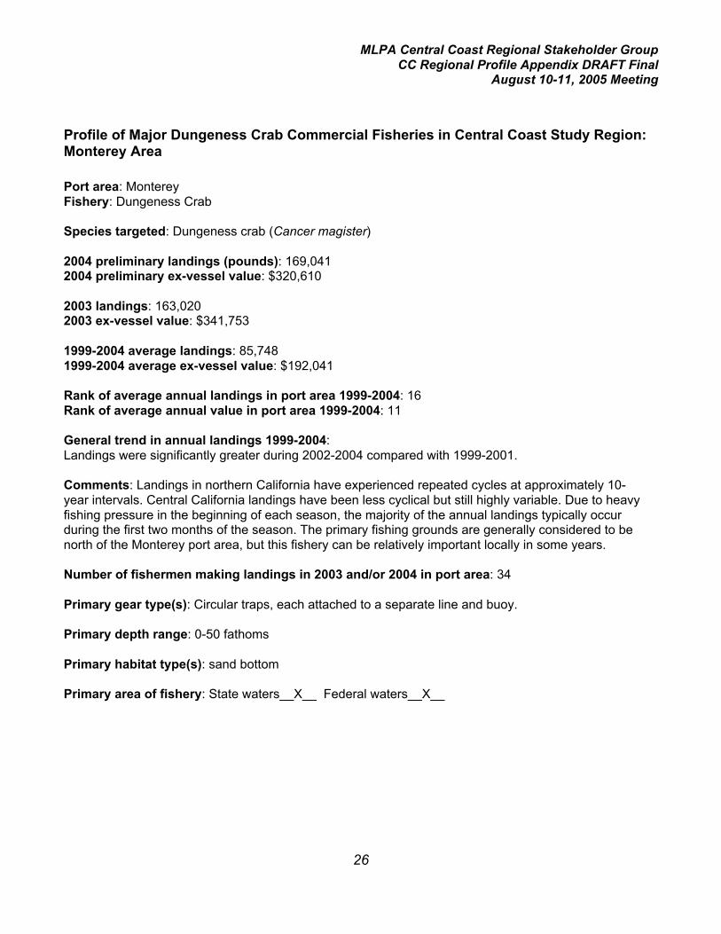
MLPA Central Coast Regional Stakeholder GroupCC Regional Profile Appendix DRAFT Final
August 10-11, 2005 Meeting
26
Profile of Major Dungeness Crab Commercial Fisheries in Central Coast Study Region:Monterey Area
Port area: MontereyFishery: Dungeness Crab
Species targeted: Dungeness crab (Cancer magister)
2004 preliminary landings (pounds): 169,0412004 preliminary ex-vessel value: $320,610
2003 landings: 163,0202003 ex-vessel value: $341,753
1999-2004 average landings: 85,7481999-2004 average ex-vessel value: $192,041
Rank of average annual landings in port area 1999-2004: 16Rank of average annual value in port area 1999-2004: 11
General trend in annual landings 1999-2004:Landings were significantly greater during 2002-2004 compared with 1999-2001.
Comments: Landings in northern California have experienced repeated cycles at approximately 10-year intervals. Central California landings have been less cyclical but still highly variable. Due to heavyfishing pressure in the beginning of each season, the majority of the annual landings typically occurduring the first two months of the season. The primary fishing grounds are generally considered to benorth of the Monterey port area, but this fishery can be relatively important locally in some years.
Number of fishermen making landings in 2003 and/or 2004 in port area: 34
Primary gear type(s): Circular traps, each attached to a separate line and buoy.
Primary depth range: 0-50 fathoms
Primary habitat type(s): sand bottom
Primary area of fishery: State waters__X__ Federal waters__X__

MLPA Central Coast Regional Stakeholder GroupCC Regional Profile Appendix DRAFT Final
August 10-11, 2005 Meeting
27
Synopsis of regulations applicable to central coast study region:Closed season July 1 through November 14. Open season may be extended as late as July 31 byorder of DFG Director.
Minimum carapace width 6.25 inches.
Only males may be harvested.
This is a restricted access fishery with a vessel-based permit system.
There is no limit on the number of traps per vessel which may be used but legislation has beenintroduced to limit the maximum number of traps .
There are no closed areas other than as specified in particular MPAs.
Log book Required?: No
Relevant spatially-explicit data concerning location of fishery:EcoTrust will provide information on the distribution of fishing effort.

MLPA Central Coast Regional Stakeholder GroupCC Regional Profile Appendix DRAFT Final
August 10-11, 2005 Meeting
28
Profile of Major Nearshore Commercial Fisheries in Central Coast Study Region:Monterey Area
Port area: MontereyFishery: Nearshore
Species targeted: nearshore rockfishes: black (Sebastes melanops), black-and-yellow (S.chrysomelas), blue (S. mystinus), brown (S. auriculatus), China (S. nebulosus), copper (S. caurinus),gopher (S. carnatus), grass (S. rastrelliger), kelp (S. atrovirens), olive (S. serranoides), treefish (S.serriceps)cabezon (Scorpaenichthys marmoratus), kelp greenling (Hexagrammos decagrammus).(Several other species defined as “nearshore” are infrequently landed in this port area, includingmonkeyface prickleback (Cebidicthys violaceous), California sheephead (Semicossyphus pulcher), andquillback rockfish (S. maliger).
2004 landings (pounds): 40,476comprised of 26,213 lbs nearshore rockfish, 13,442 lbs cabezon, 821 lbs kelp greenling2004 ex-vessel value: $180,596comprised of $112,981 nearshore rockfish, $63,114 cabezon, $4,501 kelp greenling
2003 landings: 25,823comprised of 19,280 lb nearshore rockfish, 5,827 lbs cabezon, 716 lbs kelp greenling2003 ex-vessel value: $107,438comprised of $76,898 nearshore rockfish, $26,656 cabezon, $3,884 kelp greenling
1999-2004 average landings: 59,109comprised of 40,850 lbs nearshore rockfish, 16,117 lbs cabezon, 2,142 lbs kelp greenling1999-2004 average ex-vessel value: $245,219comprised of $167,822 nearshore rockfish, $66,552 cabezon, $10,845 kelp greenling
Rank of average annual landings in port area 1999-2004:Nearshore rockfish (20)Cabezon (26)Kelp greenling (30)
Rank of average annual value in port area 1999-2004:Nearshore rockfish (12)Cabezon (19)Kelp greenling (27)
General trend in annual landings 1999-2004:A significant decline occurred in 2003 when the fishery became restricted accesswith regional permits.

MLPA Central Coast Regional Stakeholder GroupCC Regional Profile Appendix DRAFT Final
August 10-11, 2005 Meeting
29
Comments: This is primarily a live-fish fishery, and the relatively high price-per-pound generated bythese nearshore species resulted in a rapidly expanding fishery beginning in the late 1980’s. By the midto late 1990’s landings had peaked and a series of increasingly restrictive regulations were imposed,significantly reducing harvest levels, which included Total Allowable Catch allocations levels and earlyclosure of the cabezon and greenling fisheries starting in 2001 due to the attainment of those allocationamounts. This reduction continued into 2003 when the number of active permits was significantlyreduced due to the implementation of a restricted access program.
Number of fishermen making landings in 2003 and/or 2004 in port area: 58All species hook-and-line: 50All species trap: 10Nearshore rockfish hook-and-line: 48Nearshore rockfish trap: 10Cabezon hook-and-line: 38Cabezon trap: 8Kelp greenling hook-and-line: 34Kelp greenling trap: 6
Primary gear type(s): hook-and-line, stick gear (hooks attached to short piece of pvc pipe or rebar),handline, trap
Primary depth range: 0 to 20 fathoms
Primary habitat type(s): shallow reefs, kelp beds, other hard bottom
Primary area of fishery: State waters__X___ Federal waters_____
Synopsis of regulations applicable to central coast study region:A comprehensive Nearshore Fishery Management Plan (FMP) was adopted by the Fish and GameCommission in May 2002. This is one of the few fisheries in California to have a FMP.
The FMP established four management areas for the nearshore fishery; the Monterey area (Pigeon Pt.to Pt. Sur) is entirely contained within the north-central coast management area.
This is a restricted access fishery, and nearshore fishery permits may only be used within themanagement area for which they were issued. This permit allows the take of only black-and-yellow,China, gopher, grass, and kelp rockfishes, and cabezon, greenlings, California scorpionfish, andCalifornia sheephead. To take other nearshore species, one must possess a deeper nearshorefisheries permit, which is not regionally restricted.
Fishing is prohibited within the Rockfish Conservation Area from 30 to 150 fathoms from January toApril, from 20 to 150 fathoms from May to August, and from 30 to 150 fathoms from September toDecember.
There is a closed season which is variable from year to year; in 2005 the closed season is March andApril.

MLPA Central Coast Regional Stakeholder GroupCC Regional Profile Appendix DRAFT Final
August 10-11, 2005 Meeting
30
Harvest guidelines have been established for black rockfish, other nearshore rockfish, cabezon, andgreenlings (kelp and rock, the latter of which is rare in the Monterey area). Cumulative trip limits perpermit are in effect, generally on a two-month basis. The season may be closed early if the harvestguidelines are met or exceeded.
Minimum total length limits are as follows:
Black-and-yellow rockfish 10 inches
China rockfish 12 inches
Gopher rockfish 10 inches
Grass rockfish 12 inches
Kelp rockfish 10 inches
Cabezon 15 inches
Greenlings 12 inches
Log book Required?: No, however, a pilot program is underway in several port areas includingMonterey in which selected nearshore fishermen are completing experimental logbooks on a dailybasis. NOAA Fisheries’ Santa Cruz lab has obtained funding from their Economics and SocialResearch Division for this volunteer program. The program is administered jointly by NOAA Fisheries,CDFG, and Pacific States Marine Fisheries Commission.
Relevant spatially-explicit data concerning location of fishery:EcoTrust will provide information on the distribution of fishing effort.

MLPA Central Coast Regional Stakeholder GroupCC Regional Profile Appendix DRAFT Final
August 10-11, 2005 Meeting
31
Profile of Major Spot Prawn Trap Commercial Fisheries in Central Coast Study Region:Monterey Area
Port area: MontereyFishery: Spot Prawn Trap
Species targeted: Spot prawn (Pandalus platyceros)
2004 landings (pounds): 47,8042004 ex-vessel value: $519,893
2003 landings: 58,2362003 ex-vessel value: $586,299
1999-2004 average landings: 54,4231999-2004 average ex-vessel value: $510,812
Rank of average annual landings in port area 1999-2004: 18Rank of average annual value in port area 1999-2004: 6
General trend in annual landings 1999-2004: Landings in the port area peaked in 2002 when a trawlfishery operated in the same area as the trap fishery.
Comments: The harvest of spot prawns using trawl gear was prohibited beginning in 2003. A relativelysmall number of trap fishermen operate in the Monterey area with a significant and fairly consistentharvest level. Additional effort is possible beginning in 2005 because the Fish and Game Commissionapproved up to 11 trawl-to-trap“conversion” permits statewide at the end of 2004 for former spot prawntrawl fishermen (nine were purchased). Spot prawns change sex from male to female at age 3; thus thelarger prawns are all female. Spot prawns are maintained in tanks on board until landed and are sold ina live condition for $10.00 –$13.50/pound.
Number of fishermen making landings in 2003 and/or 2004 in port area: 7
Primary gear type(s): Plastic or wire mesh traps with a minimum mesh size of 7/8 by 7/8 inches. Thetraps are set in strings marked with a buoy at each end.
Primary depth range: 100-150 fathoms
Primary habitat type(s): submarine canyon; hard, soft, and mixed bottom
Primary area of fishery: State waters__X__ Federal waters__X__
Synopsis of regulations applicable to central coast study region:Restricted access fishery with a 3-tier structure. Total of 29 (17 + 3 + 9) permits statewide with norestrictions on geographical region of fishing.Tier 1 permits (17) are fully transferable. A permittee may use no more than 500 traps (only 300 in statewaters north of Pt. Arguello), and has no restrictions on landings.

MLPA Central Coast Regional Stakeholder GroupCC Regional Profile Appendix DRAFT Final
August 10-11, 2005 Meeting
32
Tier 2 permits (3) are not transferable. A permittee may use no more than 150 traps, and may land nomore than 5,000 pounds of spot prawns in a calendar year.Tier 3 (trawl-to-trap conversion) permits (9) are not transferable. A permittee may use no more than 500traps (only 300 in state waters north of Pt. Arguello), and has no restrictions on landings.
Closed season north of Pt. Arguello is May 1 to July 31. Closed season south of Pt. Arguello isNovember 1 to January 31.
All species caught incidentally in spot prawn traps must be returned to the water immediately.
Log book Required?: Yes
Relevant spatially-explicit data concerning location of fishery:EcoTrust will provide information on the distribution of fishing effort.In addition, relative fishing effort by DFG fishing block is available for 1998-99. These years are beforethe restricted access fishery began and before the trawl closure was established and thus provide abetter picture of the distribution of the resource.

MLPA Central Coast Regional Stakeholder GroupCC Regional Profile Appendix DRAFT Final
August 10-11, 2005 Meeting
33
Profile of Major Swordfish Commercial Fisheries in Central Coast Study Region:Monterey Area
Port area: MontereyFishery: Swordfish
Species targeted: Swordfish (Xiphias gladius)
2004 preliminary landings (pounds): 7,7052004 preliminary ex-vessel value: $24,880
2003 landings: 15,2422003 ex-vessel value: $41,740
1999-2004 average landings: 49,1701999-2004 average ex-vessel value: $126,532
Rank of average annual landings in port area 1999-2004: 19Rank of average annual value in port area 1999-2004: 14
General trend in annual landings 1999-2004:Almost a quarter million pounds were landed in 1999. Since then annual landings have fluctuated fromapproximately 100 pounds to more than 29,000 pounds with no trend.
Comments:Landings of swordfish off central California in general now are lower than historic landings, in partbecause one of the fishing areas which contributed to landings in the Monterey area is now closed todrift gill nets during the fall, a prime time for fishing, to protect sea turtles.
Number of fishermen making landings in 2003 and/or 2004 in port area: 6Gill net: (4)Hook-and-line: (1)Harpoon: (1)
Primary gear type(s): drift gill net, hook-and-line, harpoon
Primary depth range: surface and near-surface waters
Primary habitat type(s): open ocean, pelagic waters
Primary area of fishery: State waters_____ Federal waters__X___
Synopsis of regulations applicable to central coast study region:A highly migratory species permit is required. The drift gill net fishery is a restricted access fishery.
Log book Required?: Yes
MLPA Central Coast Regional Stakeholder GroupCC Regional Profile Appendix DRAFT Final
August 10-11, 2005 Meeting
34
Relevant spatially-explicit data concerning location of fishery:The fishery occurs primarily in federal waters. Coupled with the high mobility of the species involved,spatially explicit data will be of little value to the MLPA Initiative process.

MLPA Central Coast Regional Stakeholder GroupCC Regional Profile Appendix DRAFT Final
August 10-11, 2005 Meeting
35
Profile of Major Shark Commercial Fisheries in Central Coast Study Region: MontereyArea
Port area: MontereyFishery: Shark (this represents multiple fisheries which either target shark or harvest them incidentally)
Species targeted: thresher shark (Alopias vulpinus), shortfin mako shark (bonito shark) (Isurusoxyrinchus), spiny dogfish (Squalus acanthias), soupfin shark (Galeorhinus zyopterus)Other species landed: brown smoothhound (Mustelus henlei), leopard shark (Triakis semifasciata),Pacific angel shark (Squatina californica)
2004 preliminary landings (pounds): 46,1422004 preliminary ex-vessel value: $20,640
2003 landings: 10,8452003 ex-vessel value: $10,528
1999-2004 average landings: 35,1911999-2004 average ex-vessel value:$21,641
Rank of average annual landings in port area 1999-2004: 21Rank of average annual value in port area 1999-2004: 22
General trend in annual landings 1999-2004:Landings have varied by approximately one order of magnitude during the period, with no trend.
Comments:The two years with the highest landings, 1999 and 2004, were due primarily to landings of spinydogfish, which exceeded 40,000 pounds in each year. With the exception of 2004, thresher shark hasbeen the number one or number two shark species landed. In 1999 and 2000, significant landings(exceeding 9,000 lbs) were categorized as unspecified shark.
Number of fishermen making landings in 2003 and/or 2004 in port area:Hook-and-line: 18Gill net: 5Trawl: 19
Primary gear type(s):Hook-and-lineDrift gill net (primarily for thresher and shortfin mako sharks)Set gill net or trammel net (primarily for Pacific angel sharks)Trawl (primarily for spiny dogfish)
Primary depth range: 0 to 400 fathoms
Primary habitat type(s): open ocean, pelagic waters, nearshore waters, soft bottom, hard bottom,rocky reefs, kelp beds.
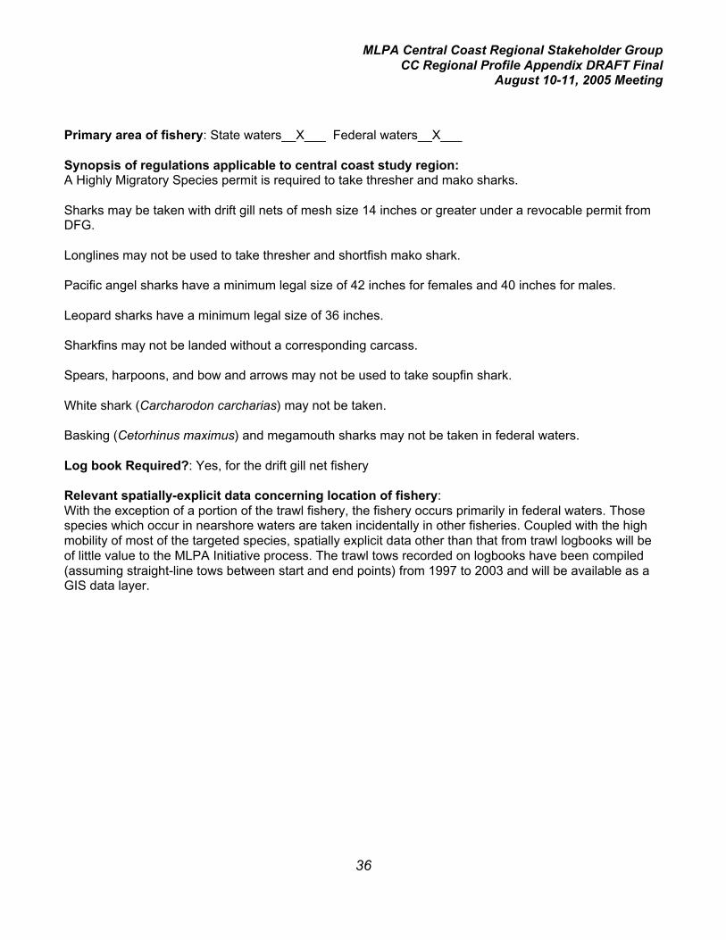
MLPA Central Coast Regional Stakeholder GroupCC Regional Profile Appendix DRAFT Final
August 10-11, 2005 Meeting
36
Primary area of fishery: State waters__X___ Federal waters__X___
Synopsis of regulations applicable to central coast study region:A Highly Migratory Species permit is required to take thresher and mako sharks.
Sharks may be taken with drift gill nets of mesh size 14 inches or greater under a revocable permit fromDFG.
Longlines may not be used to take thresher and shortfish mako shark.
Pacific angel sharks have a minimum legal size of 42 inches for females and 40 inches for males.
Leopard sharks have a minimum legal size of 36 inches.
Sharkfins may not be landed without a corresponding carcass.
Spears, harpoons, and bow and arrows may not be used to take soupfin shark.
White shark (Carcharodon carcharias) may not be taken.
Basking (Cetorhinus maximus) and megamouth sharks may not be taken in federal waters.
Log book Required?: Yes, for the drift gill net fishery
Relevant spatially-explicit data concerning location of fishery:With the exception of a portion of the trawl fishery, the fishery occurs primarily in federal waters. Thosespecies which occur in nearshore waters are taken incidentally in other fisheries. Coupled with the highmobility of most of the targeted species, spatially explicit data other than that from trawl logbooks will beof little value to the MLPA Initiative process. The trawl tows recorded on logbooks have been compiled(assuming straight-line tows between start and end points) from 1997 to 2003 and will be available as aGIS data layer.

MLPA Central Coast Regional Stakeholder GroupCC Regional Profile Appendix DRAFT Final
August 10-11, 2005 Meeting
37
Profile of Major Jacksmelt Commercial Fisheries in Central Coast Study Region:Monterey Area
Port area: MontereyFishery: Jacksmelt
Species targeted: Jacksmelt (Atherinopsis californiensis)
2004 preliminary landings (pounds): 2,1902004 preliminary ex-vessel value: $2,244
2003 landings: 8,2512003 ex-vessel value: $3,068
1999-2004 average landings: 24,5391999-2004 average ex-vessel value: $7,515
Rank of average annual landings in port area 1999-2004: 22Rank of average annual value in port area 1999-2004: 29
General trend in annual landings 1999-2004:Landings have shown high variability during the period, ranging from approximately 68,000 lbs in 2002to less than 1,000 lbs in 1999, with no trend.
Comments:This is an occasional or incidental fishery, and fluctuations observed in catch records reflect demand,not true abundance.
Number of fishermen making landings in 2003 and/or 2004 in port area: 5
Primary gear type(s): Seine
Primary depth range: 0-30 fathoms
Primary habitat type(s): nearshore, pelagic waters
Primary area of fishery: State waters__X___ Federal waters_____
Synopsis of regulations applicable to central coast study region:There is no commercial limit on the take of jacksmelt.
Log book Required?: No
Relevant spatially-explicit data concerning location of fishery:EcoTrust will provide information on the distribution of fishing effort.
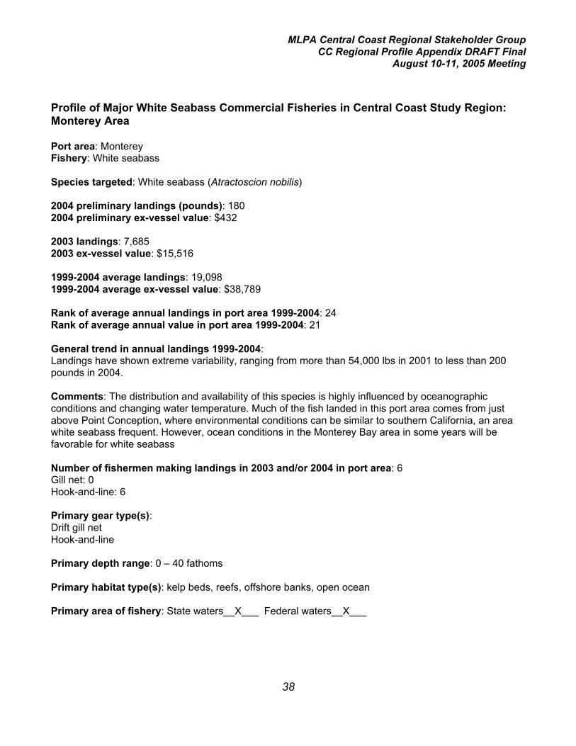
MLPA Central Coast Regional Stakeholder GroupCC Regional Profile Appendix DRAFT Final
August 10-11, 2005 Meeting
38
Profile of Major White Seabass Commercial Fisheries in Central Coast Study Region:Monterey Area
Port area: MontereyFishery: White seabass
Species targeted: White seabass (Atractoscion nobilis)
2004 preliminary landings (pounds): 1802004 preliminary ex-vessel value: $432
2003 landings: 7,6852003 ex-vessel value: $15,516
1999-2004 average landings: 19,0981999-2004 average ex-vessel value: $38,789
Rank of average annual landings in port area 1999-2004: 24Rank of average annual value in port area 1999-2004: 21
General trend in annual landings 1999-2004:Landings have shown extreme variability, ranging from more than 54,000 lbs in 2001 to less than 200pounds in 2004.
Comments: The distribution and availability of this species is highly influenced by oceanographicconditions and changing water temperature. Much of the fish landed in this port area comes from justabove Point Conception, where environmental conditions can be similar to southern California, an areawhite seabass frequent. However, ocean conditions in the Monterey Bay area in some years will befavorable for white seabass
Number of fishermen making landings in 2003 and/or 2004 in port area: 6Gill net: 0Hook-and-line: 6
Primary gear type(s):Drift gill netHook-and-line
Primary depth range: 0 – 40 fathoms
Primary habitat type(s): kelp beds, reefs, offshore banks, open ocean
Primary area of fishery: State waters__X___ Federal waters__X___

MLPA Central Coast Regional Stakeholder GroupCC Regional Profile Appendix DRAFT Final
August 10-11, 2005 Meeting
39
Synopsis of regulations applicable to central coast study region:There is a closed season south of Pt. Conception from March 15 to June 15, with an allowance for fishtaken incidental to gill and trammel net fishing.
There is a minimum legal size of 28 inches.
Mesh size of gill nets must be not less than 6 inches.
White seabass may not be taken in roundhaul nets.
Log book Required?: Yes for gill net
Relevant spatially-explicit data concerning location of fishery:EcoTrust will provide information on the distribution of fishing effort.

MLPA Central Coast Regional Stakeholder GroupCC Regional Profile Appendix DRAFT Final
August 10-11, 2005 Meeting
40
Profile of Major Lingcod Commercial Fisheries in Central Coast Study Region: MontereyArea
Port area: MontereyFishery: Lingcod
Species targeted: Lingcod (Ophiodon elongatus). Lingcod are generally not specifically targeted butare so widespread that they are caught in most hard-bottom oriented fisheries targeting rockfishes,cabezon, and other species.
2004 preliminary landings (pounds): 26,2452004 preliminary ex-vessel value: $37,369
2003 landings: 16,7922003 ex-vessel value: $21,855
1999-2004 average landings: 18,3271999-2004 average ex-vessel value: $20,606
Rank of average annual landings in port area 1999-2004: 25Rank of average annual value in port area 1999-2004: 23
General trend in annual landings 1999-2004:Landings have varied by approximately four-fold with no trend.
Comments:Prior to 1999, the Acceptable Biological Catch for lingcod set by the National Marine Fisheries Servicehad undergone a series of significant reductions, and regional and statewide landings are substantiallylower in this recent 6-year period compared with the previous two decades. Lingcod is now officiallydeclared to be an overfished species; a rebuilding plan is implemented and allowable harvest levels arerelatively low.
Number of fishermen making landings in 2003 and/or 2004 in port area:Hook-and-line: 95Trawl: 27Trap: 5Gill net: 1
Primary gear type(s):Hook-and-lineTrawlGill netTrap
Primary depth range: 2- 200 fathoms
Primary habitat type(s): deep and shallow rocky reef, kelp beds, low- to high-relief mixed substrateand hard bottom, submarine canyons.

MLPA Central Coast Regional Stakeholder GroupCC Regional Profile Appendix DRAFT Final
August 10-11, 2005 Meeting
41
Primary area of fishery: State waters__X___ Federal waters__X___
Synopsis of regulations applicable to central coast study region:Within the Rockfish Conservation Area (RCA), the taking of rockfishes, lingcod, California scorpionfish,and ocean whitefish is prohibited. Within the central coast study region (Pigeon Pt. to Pt. Conception),the RCA for commercial fishing ranges from 20 to 150 fathoms for limited entry and open access fixedgears, and from 100 to 150 fathoms for trawlers.
A federal permit is required to fish outside of the RCA. There are four types of federal permits: trawllimited entry, trawl open access, fixed gear limited entry, non-trawl open access.
Annual harvest limits and two-month cumulative trip limits are in effect.
Small footrope trawl gear is required shoreward of the RCA.
The minimum legal size for lingcod is 24 inches.
Log book Required?: Yes for trawling
Relevant spatially-explicit data concerning location of fishery:EcoTrust will provide information on the distribution of non-trawl fishing effort. Trawl tows recorded onlogbooks have been compiled (assuming straight-line tows between start and end points) from 1997 to2003 and will be available as a GIS data layer.

MLPA Central Coast Regional Stakeholder GroupCC Regional Profile Appendix DRAFT Final
August 10-11, 2005 Meeting
42
Profile of Major Butterfish Commercial Fisheries in Central Coast Study Region:Monterey Area
Port area: MontereyFishery: Butterfish (Pacific pompano)
Species targeted: Butterfish (Pacific pompano) (Peprilus simillimus)
2004 preliminary landings (pounds): 12,1992004 preliminary ex-vessel value: $16,773
2003 landings: 17,5452003 ex-vessel value: $11,376
1999-2004 average landings: 14,1691999-2004 average ex-vessel value: $14,731
Rank of average annual landings in port area 1999-2004: 27Rank of average annual value in port area 1999-2004: 26
General trend in annual landings 1999-2004:Landings have shown high variability during the period, ranging from approximately 43,000 lbs in 2002to 300 lbs in 1999, with no trend.
Comments: Generally this species is considered a very minor component in the commercial fisheries.However, it is marketed in the fresh fish markets and in local restaurants as a delicacy item.
Number of fishermen making landings in 2003 and/or 2004 in port area: Seine (4)Primary gear type(s): SeinePrimary depth range: 5-50 fathomsPrimary habitat type(s): nearshore, pelagic watersPrimary area of fishery: State waters__X___ Federal waters_____
Synopsis of regulations applicable to central coast study region:There is no commercial limit on the take of butterfish.
Log book Required?: No
Relevant spatially-explicit data concerning location of fishery:EcoTrust will provide information on the distribution of fishing effort.

MLPA Central Coast Regional Stakeholder GroupCC Regional Profile Appendix DRAFT Final
August 10-11, 2005 Meeting
43
Profile of Major Rock Crab Commercial Fisheries in Central Coast Study Region:Monterey Area
Port area: MontereyFishery: Rock crab
Species targeted:Brown rock crab (Cancer antennarius)Red rock crab (C. productus)Other species landed infrequently in port area:Yellow rock crab (C. anthonyi)
2004 preliminary landings (pounds): 2,7872004 preliminary ex-vessel value: $3,294
2003 landings: 2,0542003 ex-vessel value: $5,701
1999-2004 average landings: 6,5451999-2004 average ex-vessel value: $8,870
Rank of average annual landings in port area 1999-2004: 29Rank of average annual value in port area 1999-2004: 28
General trend in annual landings 1999-2004:A significant decline occurred from 1999 to 2001; landings have remained relatively low since them.
Comments:Commercial landing records from 1999 through 2004 show that relatively few commercial fishermentargeted rock crab in the Monterey area; thus the decision of one or several fishermen to not fish in aparticular year could have a significant impact on total landings for this port area. In addition, the areafrom Santa Cruz south to Pt. Conception is not within the range of commercial densities of rock crab,primarily due to the established presence of the southern sea otter. Landings into the port areagenerally originate from north of the Santa Cruz area.
Number of fishermen making landings in 2003 and/or 2004 in port area: 13
Primary gear type(s): Square traps, which are usually set singly (rarely in pairs) and attached to a lineand buoy.
Primary depth range: 15-40 fathoms
Primary habitat type(s): kelp bed areas, rocky reefs, mixed substrate, sand bottom.
Primary area of fishery: State waters__X___ Federal waters_____

MLPA Central Coast Regional Stakeholder GroupCC Regional Profile Appendix DRAFT Final
August 10-11, 2005 Meeting
44
Synopsis of regulations applicable to central coast study region:Minimum carapace width of 4.25 inches.
Traps must be made of wire mesh and conform to minimum mesh size and escape port regulations.Each trap must have at least one approved self-destruct device.
A Northern Rock Crab Trap Permit is required north of Lopez Point in Monterey County, and aSouthern Rock Crab Trap Permit south of that point. A northern rock crab trap permit be may be issuedto any licensed commercial fisherman who has a valid general trap permit that has not been suspendedor revoked. The northern rock crab trap permit is a non-restrictive permit with no minimum landingrequirements. The fee for either permit is $250, but there is qualifying landing criteria that the applicantmust meet to purchase a southern permit.
Log book Required?: Yes
Relevant spatially-explicit data concerning location of fishery:EcoTrust will provide information on the distribution of fishing effort.

MLPA Central Coast Regional Stakeholder GroupCC Regional Profile Appendix DRAFT Final
August 10-11, 2005 Meeting
45
SUMMARY OF MORRO BAY PORT AREA FISHERIES(ranked by average value 1999-2004)
= primarily infederal waters
FisherySpeciesTargeted
Number ofFishermenLanding in2003 Primary Gear
Primarydepth
PrimaryHabitat
State orFederalWaters?
2004 volumein pounds 2004 value
1999-2004averagevolume inpounds
1999-2004averagevalue
1999-2004AverageVolumeRank inPort
1999-2004AverageValueRank inPort
Spot prawn Spot prawn 2 traps 100-150fms canyon,hard, soft,mixedbottom
State andFederal
12k $120k 75k 605k 14 1
Nearshorefinfish
Nearshorerockfish,cabezon, kelpgreenling
87 Hook andline, trap,stick gear
0-20fms rocky reefs,kelp, otherhard bottom
State 97k rockfish;53k cabezon,2k kelpgreenling
$168krockfish,$251kcabezon,$12kgreenling
117krockfish, 75kcabezon, 5kgreening
$562krockfish,$346kcabezon,$28kgreenling
11,13,26 2,3,22
Albacore /other tuna
Albacore, bigeye,bluefin, yellowfin,skipjack tunas
70 troll hook-and-line,seine
surface andsubsurfacewaters
open ocean,pelagicwaters
Federal 37k albacore,5k othertunas
$41kalbacore, $7kother tunas
674kalbacore, 37kother tuna
$527kalbacore,$51k othertuna
2,16 4,17
Swordfish Swordfish 9 gill net surface andnear-surfacewaters
open ocean,pelagicwaters
Federal 21k $73k 120k $341k 9 5
Salmon King (chinook)salmon
68 troll hook-and-line
surface to50 fms
pelagic,open ocean
State andFederal
64k $231 118K $246K 10 6
Oceanshrimp
Ocean shrimp 2 Trawls withfish excluders
40-125fms green mud,mud/sandbottom
Federal 582k $266k 511k $224k 4 7
Dover sole /thornyhead /sablefish
Dover sole,longspine andshortspinethornyheads,sablefish
1-18 permitsfor 9 distinctgear/speciescombinations
bottom trawl,longline, gilnets, trap
150-700 soft bottom,low-reliefmixed andhard bottom
Federal 687k sole,314kthornyheads,178ksablefish
$233k sole,$189kthornyheads,$170ksablefish
641k sole,303kthornyheads,139ksablefish
$219k sole,$197kthornyheads,$129ksablefish
3,5,8 8,9,13
Otherflatfishes
Soles, sanddab,turbot
21 bottom trawl 30-700fms low-reliefsoft bottom
Federal 375k $433k 186k $170k 7 10
Market squid market squid 12 seine, brail 5-30fms sand State 2 million $445k 738k $150k 1 11

MLPA Central Coast Regional Stakeholder GroupCC Regional Profile Appendix DRAFT Final
August 10-11, 2005 Meeting
46
FisherySpeciesTargeted
FishermenLanding in2003 Primary Gear
Primarydepth
PrimaryHabitat
State orFederalWaters
2004 volumein pounds 2004 value
1999-2004averagevolume
1999-2004averagevalue
1999-04VolumeRank
1999-04ValueRank
Sloperockfish /grenadier
several "slope"rockfish species,grenadier
6-14 permitsfor fourdistinctgear/specescombinations
bottom trawl,set longline
200-700fms soft bottomoncontinentalslope,submarinecanyons
Federal 215k sloperockfish, 0.1kgrenadier
$134k sloperockfish,<$1kgrenadier
245k sloperockfish, 8kkgrenadier
$145k sloperockfish, $1kgrenadier
6,25 12,26
Rock crab Brown, red, andyellow rock crab
19 traps 7-30fms kelp beds,rocky reefs,mixedsubstrate,sand
State 48k $110k 83k $116k 12 14
Californiahalibut
California halibut Hook-and-line38, trawl 9,gill net 1
Hook-and-line, trawl, gillnet
2-50fms sand State andFederal
5k $16k 36k $93k 17 15
Dungenesscrab
Dungeness crab 13 traps 0-50fms sand State andFederal
23k $83k 17k $58k 20 16
Whiteseabass
White seabass Hook-and-line17, gill net 2
Hook-and-line, gill net
0-40fms kelp, reefs,offshorebanks, openocean
State andFederal
2k $4k 15k $33k 22 18
Surfperch Surfperch 66 Hook-and-line 0-10fms sand State 26k $51k 15k $30k 21 19
Shelfrockfish
24 species ofshelf rockfish
Hook-and-line76, trawl 4,gill net 1
bottom trawl,midwatertrawl,longline,hook-and-line,gill net
30-200fms deep rockyreefs,cobble andsand,canyonedges
State andFederal
12k $20k 45k $29k 15 20
Lingcod Lingcod Hook-and-line88, trawl 11,trap 16, gillnet 1
Hook-and-line, trawl, gillnet, trap
2-200fms deep andshallowrocky reef,kelp, low- tohigh-reliefmixedsubstrate,canyons
State andFederal
25k $40k 19k $29k 19 21
Red urchin Red urchin 2 hand harvestwith scuba orhooka gear
2-15fms rocky reefs,kelp, hardbottom
State 18k $15k 14k $11k 23 25

MLPA Central Coast Regional Stakeholder GroupCC Regional Profile Appendix DRAFT Final
August 10-11, 2005 Meeting
47
Morro Bay port area landings (pounds)
Year 1999 2000 2001 2002 2003 20046-year
averageFINFISH (preliminary)Albacore 319,493 871,342 1,884,361 536,568 393,881 36,842 673,748Dover sole 984,563 506,999 265,381 628,223 775,472 686,769 641,235Thornyheads 379,996 223,672 92,283 402,152 404,710 313,829 302,774Rockfish slope 122,061 157,732 139,534 563,540 275,341 214,586 245,466Other flatfish 130,401 101,631 224,236 90,139 193,203 375,450 185,843Sablefish 189,201 88,652 63,613 124,201 188,263 178,066 138,666Swordfish 203,852 292,250 118,975 56,160 27,773 21,284 120,049King salmon* 26,665 428,811 32,356 133,004 21,488 63,778 117,684Rockfish nearshore 167,257 110,826 131,610 102,419 91,259 96,931 116,717Cabezon 129,423 95,512 72,968 50,854 50,277 52,698 75,289Rockfish shelf 157,790 66,968 15,663 8,661 9,502 12,238 45,137Other tuna 19,287 43,950 129,178 2,971 22,828 4,600 37,136California halibut 77,533 40,035 63,123 17,509 10,514 5,086 35,633Shark 33,960 26,395 30,974 15,076 16,249 19,114 23,628Lingcod 28,499 5,986 13,300 18,484 20,714 25,041 18,671Surfperch 9,192 9,860 11,209 11,611 24,039 25,565 15,246White seabass 16,887 3,600 34,559 20,096 10,139 1,774 14,509Rockfish other 47,757 6,920 4,321 2,297 1,241 1,899 10,739Grenadier 28,915 2,521 4,738 7,229 4,717 158 8,046Kelp greenling 3,229 8,340 4,989 5,255 3,772 1,949 4,589*From DFG Ocean Salmon Project records
INVERTEBRATESMarket squid 39,512 9 174,994 785,177 1,433,503 1,996,713 738,318Ocean shrimp 278,024 303,273 247,412 743,999 913,116 581,646 511,245Rock crab 93,045 75,885 102,358 119,177 56,831 48,331 82,605Spot prawn 126,000 130,047 77,839 98,222 5,225 11,551 74,814Dungeness crab 1,521 5,375 8,660 31,894 30,357 23,064 16,812Red urchin 6,274 0 9,122 16,922 31,586 18,349 13,709
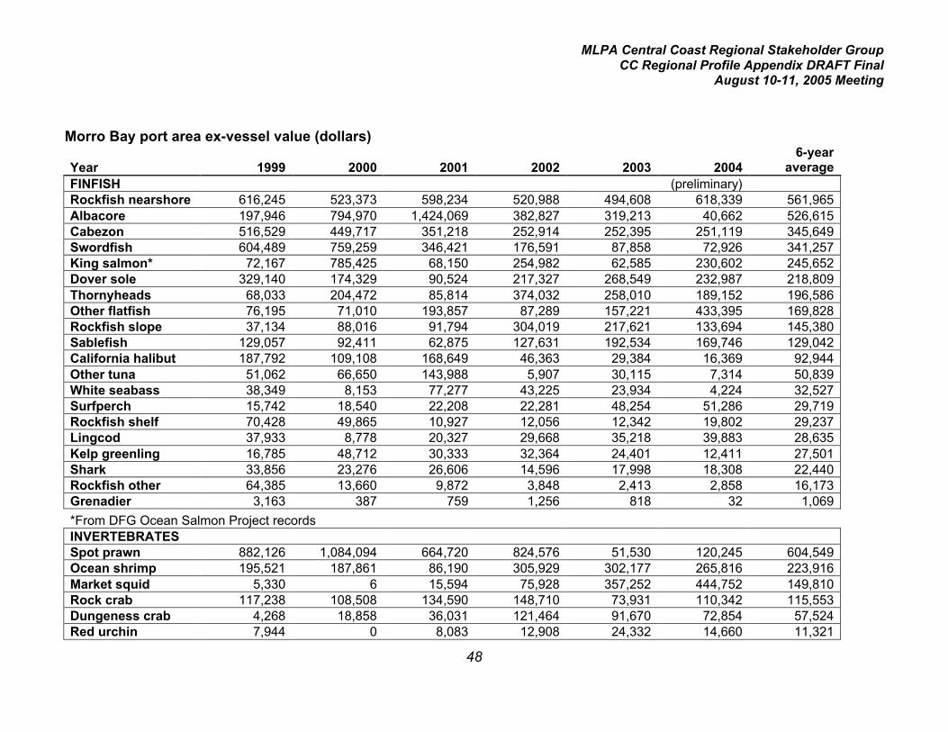
MLPA Central Coast Regional Stakeholder GroupCC Regional Profile Appendix DRAFT Final
August 10-11, 2005 Meeting
48
Morro Bay port area ex-vessel value (dollars)
Year 1999 2000 2001 2002 2003 20046-year
averageFINFISH (preliminary)Rockfish nearshore 616,245 523,373 598,234 520,988 494,608 618,339 561,965Albacore 197,946 794,970 1,424,069 382,827 319,213 40,662 526,615Cabezon 516,529 449,717 351,218 252,914 252,395 251,119 345,649Swordfish 604,489 759,259 346,421 176,591 87,858 72,926 341,257King salmon* 72,167 785,425 68,150 254,982 62,585 230,602 245,652Dover sole 329,140 174,329 90,524 217,327 268,549 232,987 218,809Thornyheads 68,033 204,472 85,814 374,032 258,010 189,152 196,586Other flatfish 76,195 71,010 193,857 87,289 157,221 433,395 169,828Rockfish slope 37,134 88,016 91,794 304,019 217,621 133,694 145,380Sablefish 129,057 92,411 62,875 127,631 192,534 169,746 129,042California halibut 187,792 109,108 168,649 46,363 29,384 16,369 92,944Other tuna 51,062 66,650 143,988 5,907 30,115 7,314 50,839White seabass 38,349 8,153 77,277 43,225 23,934 4,224 32,527Surfperch 15,742 18,540 22,208 22,281 48,254 51,286 29,719Rockfish shelf 70,428 49,865 10,927 12,056 12,342 19,802 29,237Lingcod 37,933 8,778 20,327 29,668 35,218 39,883 28,635Kelp greenling 16,785 48,712 30,333 32,364 24,401 12,411 27,501Shark 33,856 23,276 26,606 14,596 17,998 18,308 22,440Rockfish other 64,385 13,660 9,872 3,848 2,413 2,858 16,173Grenadier 3,163 387 759 1,256 818 32 1,069
*From DFG Ocean Salmon Project recordsINVERTEBRATESSpot prawn 882,126 1,084,094 664,720 824,576 51,530 120,245 604,549Ocean shrimp 195,521 187,861 86,190 305,929 302,177 265,816 223,916Market squid 5,330 6 15,594 75,928 357,252 444,752 149,810Rock crab 117,238 108,508 134,590 148,710 73,931 110,342 115,553Dungeness crab 4,268 18,858 36,031 121,464 91,670 72,854 57,524Red urchin 7,944 0 8,083 12,908 24,332 14,660 11,321

MLPA Central Coast Regional Stakeholder GroupCC Regional Profile Appendix DRAFT Final
August 10-11, 2005 Meeting
49
Profile of Major Dover Sole/ Thorneyhead/Sablefish Commercial Fisheries in CentralCoast Study Region: Morro Bay Area
Port area: Morro BayFishery: Dover sole/thornyhead/sablefish
Species targeted: Dover sole (Microstomus pacificus), longspine thornyhead (Sebastolobus altivelis),shortspine thornyhead (S. alascanus), sablefish (Anoplopoma fimbria)
2004 preliminary landings (pounds): 1,178,664comprised of 686,769 lbs Dover sole, 313,829 lbs thornyheads, 178,066 lbs sablefish2004 preliminary ex-vessel value: $591,885comprised of $232,987 Dover sole, $189,152 thornyheads, $169,746 sablefish
2003 landings: 1,368,445comprised of 775,472 lbs Dover sole, 404,710 lbs thornyheads, 188,263 lbs sablefish2003 ex-vessel value: $719,093comprised of $268,549 Dover sole, $258,010 thornyheads, $192,534 sablefish
1999-2004 average landings: 1,082,765comprised of 641,235 lbs Dover sole, 302,774 lbs thornyheads, 138,666 lbs sablefish1999-2004 average ex-vessel value: $544,437comprised of $218,809 Dover sole, $196,586 thornyheads, $129,042 sablefish
Rank of average annual landings in port area 1999-2004:Dover sole (3)Thornyheads (5)Sablefish (8)
Rank of average annual value in port area 1999-2004:Dover sole (8)Thornyheads (9)Sablefish (13)
General trend in annual landings 1999-2004:Landings for each group have varied by approximately three- to four-fold with no trend, although 2001was the lowest year of landings for all groups within the period.
Comments:Unlike the Monterey area, the establishment of the Rockfish Conservation Area (RCA) in continentalshelf waters did not appear to have any negative impact of landings of the DTS complex in this area.Although statewide trawl effort has been reduced recently due to a federal groundfish buyback programwhich has retired some trawl vessels, this also seems to have had a minimal impact on Morro Bay arealandings for these species. Thornyheads caught by longline gear are retained on board and sold in alive condition, increasing their market value in recent years.

MLPA Central Coast Regional Stakeholder GroupCC Regional Profile Appendix DRAFT Final
August 10-11, 2005 Meeting
50
Number of fishermen making landings in 2003 and/or 2004 in port area:All species trawl: 18Thornyheads and/or sablefish hook-and-line: 9 Dover sole trawl: 15Thornyheads hook-and-line: 2Thornyheads trawl: 18Sablefish hook-and-line: 9Sablefish trap: 1Sablefish trawl: 18Sablefish gill net: 3
Primary gear type(s): bottom trawl, longline (thornyheads and sablefish), gill nets (sablefish), trap(sablefish)
Primary depth range: 150-700 fathoms
Primary habitat type(s): soft bottom, low-relief mixed and hard bottom
Primary area of fishery: State waters_____ Federal waters__X___
Synopsis of regulations applicable to central coast study region:Trawling is prohibited within 3 miles of shore.
A federal permit is required to fish outside of the RCA. There are four types of federal permits: trawllimited entry, trawl open access, fixed gear limited entry, non-trawl open access.Trawl limited entry:Dover sole: two-month harvest limits.Thornyheads: two-month harvest limits.Sablefish: two-month harvest limits.
Trawl open access:Dover sole: monthly harvest limits.Thornyheads: may not be taken.Sablefish: daily, weekly, and two-month harvest limits.
Fixed gear limited entry:Dover sole: monthly harvest limits.Thornyheads: two-month harvest limits.Sablefish: daily, weekly, and two-month harvest limits.
Non-trawl open access:Dover sole: monthly harvest limits.Thornyheads: may not be takenSablefish: daily, weekly, and two-month harvest limits.
All trawl gear is permitted seaward of the RCA.
Log book Required?: Yes for trawl and sablefish trap

MLPA Central Coast Regional Stakeholder GroupCC Regional Profile Appendix DRAFT Final
August 10-11, 2005 Meeting
51
Relevant spatially-explicit data concerning location of fishery:Although the fishery occurs primarily in federal waters, a small amount of trap effort occurs within statewaters in submarine canyon areas. Although all trawling occurs outside state waters in this portion ofthe study region, trawl tows recorded on logbooks have been compiled (assuming straight-line towsbetween start and end points) from 1997 to 2003 and will be available as a GIS data layer. EcoTrustwill provide information on the distribution of non-trawl sablefish fishing effort.
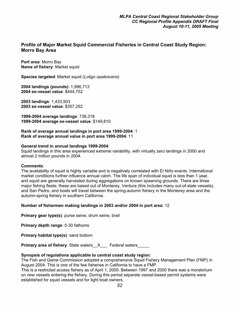
MLPA Central Coast Regional Stakeholder GroupCC Regional Profile Appendix DRAFT Final
August 10-11, 2005 Meeting
52
Profile of Major Market Squid Commercial Fisheries in Central Coast Study Region:Morro Bay Area
Port area: Morro BayName of fishery: Market squid
Species targeted: Market squid (Loligo opalescens)
2004 landings (pounds): 1,996,7132004 ex-vessel value: $444,752
2003 landings: 1,433,5032003 ex-vessel value: $357,252
1999-2004 average landings: 738,3181999-2004 average ex-vessel value: $149,810
Rank of average annual landings in port area 1999-2004: 1Rank of average annual value in port area 1999-2004: 11
General trend in annual landings 1999-2004:Squid landings in this area experienced extreme variability, with virtually zero landings in 2000 andalmost 2 million pounds in 2004.
Comments:The availability of squid is highly variable and is negatively correlated with El Niño events. Internationalmarket conditions further influence annual catch. The life span of individual squid is less than 1 year,and squid are generally harvested during aggregations on known spawning grounds. There are threemajor fishing fleets; these are based out of Monterey, Ventura (this includes many out-of-state vessels),and San Pedro, and boats will travel between the spring-autumn fishery in the Monterey area and theautumn-spring fishery in southern California.
Number of fishermen making landings in 2003 and/or 2004 in port area: 12
Primary gear type(s): purse seine, drum seine, brail
Primary depth range: 5-30 fathoms
Primary habitat type(s): sand bottom
Primary area of fishery: State waters__X___ Federal waters_____
Synopsis of regulations applicable to central coast study region:The Fish and Game Commission adopted a comprehensive Squid Fishery Management Plan (FMP) inAugust 2004. This is one of the few fisheries in California to have a FMP.This is a restricted access fishery as of April 1, 2005. Between 1997 and 2000 there was a moratoriumon new vessels entering the fishery. During this period separate vessel-based permit systems wereestablished for squid vessels and for light boat owners.
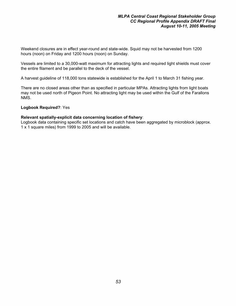
MLPA Central Coast Regional Stakeholder GroupCC Regional Profile Appendix DRAFT Final
August 10-11, 2005 Meeting
53
Weekend closures are in effect year-round and state-wide. Squid may not be harvested from 1200hours (noon) on Friday and 1200 hours (noon) on Sunday.
Vessels are limited to a 30,000-watt maximum for attracting lights and required light shields must coverthe entire filament and be parallel to the deck of the vessel.
A harvest guideline of 118,000 tons statewide is established for the April 1 to March 31 fishing year.
There are no closed areas other than as specified in particular MPAs. Attracting lights from light boatsmay not be used north of Pigeon Point. No attracting light may be used within the Gulf of the FarallonsNMS.
Logbook Required?: Yes
Relevant spatially-explicit data concerning location of fishery:Logbook data containing specific set locations and catch have been aggregated by microblock (approx.1 x 1 square miles) from 1999 to 2005 and will be available.

MLPA Central Coast Regional Stakeholder GroupCC Regional Profile Appendix DRAFT Final
August 10-11, 2005 Meeting
54
Profile of Major Albacore and other Tuna Commercial Fisheries in Central Coast StudyRegion: Morro Bay Area
Port area: Morro BayFishery: Albacore/other tuna
Species targeted: albacore (Thunnus alalunga)Other species harvested: bigeye tuna (Thunnus obesus), bluefin tuna (T. thynnus), yellowfin tuna (T.albacares), skipjack (Euthynnus pelamis)
2004 preliminary landings (pounds): 41,422comprised of 36,842 lbs albacore, 4,600 other tuna2004 preliminary ex-vessel value: $47,976comprised of $40,662 albacore, $7,314 other tuna
2003 landings: 398,481comprised of 393,881 lbs albacore, 4,600 lbs other tuna2003 ex-vessel value: $326,527comprised of $319,213 albacore, $7,314 other tuna
1999-2004 average landings: 710,884comprised of 673,748 lbs albacore, 37,136 lbs other tuna1999-2004 average ex-vessel value: $577,454comprised of $526,615 albacore, $50,839 other tuna
Rank of average annual landings in port area 1999-2004:Albacore (2)Other tuna (16)
Rank of average annual value in port area 1999-2004:Albacore (3)Other tuna (17)
General trend in annual landings 1999-2004:Albacore landings have declined steadily since 2001 from approximately 1.9 million lbs to less than40,000 lbs. Landings of other tuna exceeded 125,000 lbs in 2001, primarily due to bluefin tuna, andhave ranged from 3,000 to 23,000 lbs since then.
Comments:The abundance of that portion of the Pacific Ocean’s albacore stocks available to the local fleet hasfluctuated considerably over the last several decades, with strong and weak periods occurringintermittently.
Number of fishermen making landings in 2003 and/or 2004 in port area: 70
Primary gear type(s): troll hook-and-line, purse seine
Primary depth range: surface and subsurface waters

MLPA Central Coast Regional Stakeholder GroupCC Regional Profile Appendix DRAFT Final
August 10-11, 2005 Meeting
55
Primary habitat type(s): open ocean, pelagic waters
Primary area of fishery: State waters_____ Federal waters__X___
Synopsis of regulations applicable to central coast study region:Must possess a federal Highly Migratory Species fishery permit
Log book Required?: Yes
Relevant spatially-explicit data concerning location of fishery:The fishery occurs primarily in federal waters. Coupled with the high mobility of the species involved,spatially explicit data will be of little value to the MLPA Initiative process.

MLPA Central Coast Regional Stakeholder GroupCC Regional Profile Appendix DRAFT Final
August 10-11, 2005 Meeting
56
Profile of Major Ocean Shrimp Commercial Fisheries in Central Coast Study Region:Morro Bay Area
Port area: Morro BayFishery: Ocean shrimp
Species targeted: Ocean shrimp (pink shrimp) (Pandalus jordani)
2004 preliminary landings (pounds): 581,6462004 preliminary ex-vessel value: $265,816
2003 landings: 913,1162003 ex-vessel value: $302,177
1999-2004 average landings: 511,2451999-2004 average ex-vessel value: $223,916
Rank of average annual landings in port area 1999-2004: 4Rank of average annual value in port area 1999-2004: 7
General trend in annual landings 1999-2004:Landings were almost three times higher from 2002 to 2004 compared with 1999 to 2001.
Comments: Ocean shrimp population abundance off California is determined by environmentalconditions, which cause natural fluctuations in recruitment that are apparently unrelated or minimallyrelated to commercial fishing effort. Concentrations of shrimp generally remain in well defined areas orbeds in northern California from year-to-year. South of Pigeon Point there are not established beds.There are no longer any processors in California purchasing ocean shrimp and ex-vessel prices inOregon are at an all time low. Small amounts of ocean shrimp may be sold directly to the public atharbor fish markets.
Number of fishermen making landings in 2003 and/or 2004 in port area: 2
Primary gear type(s): Double- and single-rigged otter trawls with fish excluders.
Primary depth range: 40 -125 fathoms
Primary habitat type(s): green mud, mud/sand bottom
Primary area of fishery: State waters_____ Federal waters__X___
Synopsis of regulations applicable to central coast study region:This is a restricted access fishery and a regional permit is required.
The season is closed November 1 through March 31
A maximum count per pound of 160 is required (equivalent to an average minimum size)

MLPA Central Coast Regional Stakeholder GroupCC Regional Profile Appendix DRAFT Final
August 10-11, 2005 Meeting
57
The minimum mesh size for a trawl net is 1 and 3/8 inches.
An approved Bycatch Reduction Device (fish excluder) is required on all nets.
Trawling is prohibited within three miles of shore in this region.
Limits are in effect for the maximum amount of fish which may be landed incidental to ocean shrimp.
Spot prawns shall not be landed as incidental catch.
Log book Required?: Yes
Location-specific catch data available from logbooks? Standard block data.
Years of data included here: Logbook data for 2004-2005 have been entered in a database. Previousyears has never been entered into a database.

MLPA Central Coast Regional Stakeholder GroupCC Regional Profile Appendix DRAFT Final
August 10-11, 2005 Meeting
58
Profile of Major Slope Rockfish/GrenadierCommercial Fisheries in Central Coast StudyRegion: Morro Bay Area
Port area: Morro BayFishery: Slope rockfish/grenadier
Species targeted: slope rockfishes: splitnose (Sebastes diploproa), darkblotched (S. crameri)Grenadiers (Pacific rattail- Coryphaenoides acrolepis)
Other rockfish species landed: aurora (S. aurora), bank (S. rufus), blackgill (S. melanostomus), Pacificocean perch (S. alutus), redbanded (S. babcocki), sharpchin (S. zacentrus)
2004 preliminary landings (pounds): 214,744comprised of 214,586 lbs slope rockfish, 158 lbs grenadier2004 preliminary ex-vessel value: $133,726comprised of $133,694 slope rockfish, $32 grenadier
2003 landings: 280,058comprised of 275,341 lbs slope rockfish, 4,717 lbs grenadier2003 ex-vessel value: $218,439comprised of $217,621 slope rockfish, $818 grenadier
1999-2004 average landings: 253,511comprised of 245,466 lbs slope rockfish, 8,046 lbs grenadier1999-2004 average ex-vessel value: $146,449comprised of $145,380 slope rockfish, $1,069 grenadier
Rank of average annual landings in port area 1999-2004:Slope rockfish (6)Grenadier (25)
Rank of average annual value in port area 1999-2004:Slope rockfish (12)Grenadier (26)
General trend in annual landings 1999-2004:Slope rockfish landings increased dramatically from 1999 through 2002. Landings in 2002 and 2003were 2-3 times those of 2001. Landings of grenadier, although historically not at high levels, declinedsignificantly after 1999 and in 2004 were insignificant.
Comments:It is likely that the increased landings of slope rockfish were in part due to a shift in trawl fishing effort todeeper water with the establishment of the Rockfish Conservation Area (RCA) in continental shelfwaters. The RCA is a long-term fishery closure to all bottom gear targeting rockfish. The sloperockfish/grenadier fishery occurs in the same general area as the Dover sole/sablefish/thornyheadfishery.
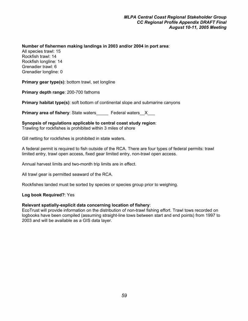
MLPA Central Coast Regional Stakeholder GroupCC Regional Profile Appendix DRAFT Final
August 10-11, 2005 Meeting
59
Number of fishermen making landings in 2003 and/or 2004 in port area:All species trawl: 15Rockfish trawl: 14Rockfish longline: 14Grenadier trawl: 6Grenadier longline: 0
Primary gear type(s): bottom trawl, set longline
Primary depth range: 200-700 fathoms
Primary habitat type(s): soft bottom of continental slope and submarine canyons
Primary area of fishery: State waters_____ Federal waters__X___
Synopsis of regulations applicable to central coast study region:Trawling for rockfishes is prohibited within 3 miles of shore
Gill netting for rockfishes is prohibited in state waters.
A federal permit is required to fish outside of the RCA. There are four types of federal permits: trawllimited entry, trawl open access, fixed gear limited entry, non-trawl open access.
Annual harvest limits and two-month trip limits are in effect.
All trawl gear is permitted seaward of the RCA.
Rockfishes landed must be sorted by species or species group prior to weighing.
Log book Required?: Yes
Relevant spatially-explicit data concerning location of fishery:EcoTrust will provide information on the distribution of non-trawl fishing effort. Trawl tows recorded onlogbooks have been compiled (assuming straight-line tows between start and end points) from 1997 to2003 and will be available as a GIS data layer.

MLPA Central Coast Regional Stakeholder GroupCC Regional Profile Appendix DRAFT Final
August 10-11, 2005 Meeting
60
Profile of Major Nearshore Commercial Fisheries in Central Coast Study Region: MorroBay Area
Port area: Morro BayFishery: Nearshore
Species targeted: nearshore rockfishes: black (Sebastes melanops), black-and-yellow (S.chrysomelas), blue (S. mystinus), brown (S. auriculatus), China (S. nebulosus), copper (S. caurinus),gopher (S. carnatus), grass (S. rastrelliger), kelp (S. atrovirens), olive (S. serranoides), treefish (S.serriceps)cabezon (Scorpaenichthys marmoratus), kelp greenling (Hexagrammos decagrammus)(Several other species defined as “nearshore” are infrequently landed in this port area, including calicorockfish (Sebastes dalli) monkeyface prickleback (Cebidicthys violaceous), California sheephead(Semicossyphus pulcher), and quillback rockfish (S. maliger).
2004 landings (pounds): 151,578comprised of 96,931 lbs nearshore rockfish, 52,698 lbs cabezon, 1,949 lbs kelp greenling2004 ex-vessel value: $ 881,869comprised of $618,339 nearshore rockfish, $251,119 cabezon, $12,411 kelp greenling
2003 landings: 145,308comprised of 91,259 lb nearshore rockfish, 50,277 lbs cabezon, 3,772 lbs kelp greenling2003 ex-vessel value: $771,404comprised of $494,608 nearshore rockfish, $252,395 cabezon, $24,401 kelp greenling
1999-2004 average landings: 196,595comprised of 116,717 lbs nearshore rockfish, 75,289 lbs cabezon, 4,589 lbs kelp greenling1999-2004 average ex-vessel value: $935,115comprised of $561,965 nearshore rockfish, $345,649 cabezon, $27,501 kelp greenling
Rank of average annual landings in port area 1999-2004:Nearshore rockfish (11)Cabezon (13)Kelp greenling (26)
Rank of average annual value in port area 1999-2004:Nearshore rockfish (2)Cabezon (3)Kelp greenling (22)
General trend in annual landings 1999-2004:Landings in 2004 were 50 to 60% of those in 1999.

MLPA Central Coast Regional Stakeholder GroupCC Regional Profile Appendix DRAFT Final
August 10-11, 2005 Meeting
61
Comments: This is primarily a live-fish fishery, and the relatively high price-per-pound generated bythese nearshore species resulted in a rapidly expanding fishery beginning in the late 1980’s. By the midto late 1990’s landings had peaked and a series of increasingly restrictive regulations were imposed,significantly reducing harvest levels which included Total Allowable Catch allocations levels and earlyclosure of the cabezon and greenling fisheries starting in 2001 due to the attainment of those allocationamounts. This reduction continued into 2003 when the number of active permits was reduced due tothe implementation of a restricted access program.
Number of fishermen making landings in 2003 and/or 2004 in port area: 87All species hook-and-line: 87All species trap: 27Nearshore rockfish hook-and-line: 87Nearshore rockfish trap: 26Cabezon hook-and-line: 58Cabezon trap: 26Kelp greenling hook-and-line: 49Kelp greenling trap: 23
Primary gear type(s): hook-and-line, stick gear (hooks attached to short piece of pvc pipe or rebar),handline, trap
Primary depth range: 0 to 20 fathoms
Primary habitat type(s): shallow reefs, kelp beds, other hard bottom
Primary area of fishery: State waters__X___ Federal waters_____
Synopsis of regulations applicable to central coast study region:A comprehensive Nearshore Fishery Management Plan (FMP) was adopted by the Fish and GameCommission in May 2002. This is one of the few fisheries in California to have a FMP.
The FMP established four management areas for the nearshore fishery; the Morro Bay area (Pt. Sur toPt. Conception) includes one entire regional management area (south-central, from Lopez Pt. to Pt.Conception), and part of another, the north-central.
This is a restricted access fishery, and nearshore fishery permits may only be used within themanagement area for which they were issued. This permit allows the take of only black-and-yellow,China, gopher, grass, and kelp rockfishes, and cabezon, greenlings, California scorpionfish, andCalifornia sheephead. To take other nearshore species, one must possess a deeper nearshorefisheries permit, which is not regionally restricted.
Fishing is prohibited within the Rockfish Conservation Area from 30 to 150 fathoms from January toApril, from 20 to 150 fathoms from May to August, and from 30 to 150 fathoms from September toDecember.
There is a closed season which is variable from year to year; in 2005 the closed season is March andApril.

MLPA Central Coast Regional Stakeholder GroupCC Regional Profile Appendix DRAFT Final
August 10-11, 2005 Meeting
62
Harvest guidelines have been established for black rockfish, other nearshore rockfish, cabezon, andgreenlings (kelp and rock, the latter of which is rare in the Morro Bay area). Cumulative trip limits perpermit are in effect, generally on a two-month basis.
The season may be closed early if the harvest guidelines are met or exceeded.
Minimum total length limits are as follows:
Black-and-yellow rockfish 10 inches
China rockfish 12 inches
Gopher rockfish 10 inches
Grass rockfish 12 inches
Kelp rockfish 10 inches
Cabezon 15 inches
Greenlings 12 inches
Log book Required?: No, however, a pilot program is underway in several port areas including MorroBay in which selected nearshore fishermen are completing experimental logbooks on a daily basis.NOAA Fisheries’ Santa Cruz lab has obtained funding from their Economics and Social ResearchDivision for this volunteer program. The program is administered jointly by NOAA Fisheries, CDFG, andPacific States Marine Fisheries Commission.
Relevant spatially-explicit data concerning location of fishery:EcoTrust will provide information on the distribution of fishing effort.

MLPA Central Coast Regional Stakeholder GroupCC Regional Profile Appendix DRAFT Final
August 10-11, 2005 Meeting
63
Profile of Major other Flatfish Commercial Fisheries in Central Coast Study Region:Morro Bay Area
Port area: Morro BayFishery: Other flatfishes
Species targeted: Petrale sole (Eopsetta jordani)Other species landed: English sole (Parophrys vetulus), rock sole (Lepidopsetta bilineata), Pacificsanddab (Citharichthys sordidus), rex sole (Glyptocephalus zachirus), sand sole (Psettichthysmelanostictus), slender sole (Lyopsetta exilis), starry flounder (Platichthys stellatus), turbot(Pleuronichthys spp.).
2004 preliminary landings (pounds): 375,4502004 preliminary ex-vessel value: $433,395
2003 landings: 193,2032003 ex-vessel value: $157,221
1999-2004 average landings: 185,8431999-2004 average ex-vessel value: $169,828
Rank of average annual landings in port area 1999-2004: 7Rank of average annual value in port area 1999-2004: 10
General trend in annual landings 1999-2004:Other flatfish landings increased by more than four-fold from 2002 to 2004; Petrale, English, and rexsole comprised 87% of the 2004 landings. Unlike the Monterey area, sanddabs are of minor importancein the flatfish fishery.
Comments:With the establishment of the Rockfish Conservation Area in 2002, trawling was prohibited in 75-150fathoms or 100-150 fathoms, depending on time of year. However, in trawlable areas outside of theRCA, bimonthly trip limits were increased for flatfishes in 2004.
Number of fishermen making landings in 2003 and/or 2004 in port area: 21
Primary gear type(s): bottom trawl
Primary depth range: 30-700 fathoms
Primary habitat type(s): low-relief soft bottom
Primary area of fishery: State waters_____ Federal waters__X___
Synopsis of regulations applicable to central coast study region:Within the Rockfish Conservation Area (RCA) along the central coast, trawling is prohibited between 75and 150 fathoms from November through February, and from 100 and 150 fathoms the rest of the year.

MLPA Central Coast Regional Stakeholder GroupCC Regional Profile Appendix DRAFT Final
August 10-11, 2005 Meeting
64
Trawling is prohibited within 3 miles of shore.
A federal permit is required to fish outside of the RCA. There are four types of federal permits: trawllimited entry, trawl open access, fixed gear limited entry, non-trawl open access.
Two-month harvest limits are in effect for “other flatfish” which, under the definition of the PacificFishery Management Council, includes sanddabs.Within these limits, Petrale sole has its own limit.
Small footrope trawl gear is required shoreward of the RCA.
Log book Required?: Yes
Relevant spatially-explicit data concerning location of fishery:The fishery occurs primarily in federal waters; however, some flatfish other than halibut are takenincidentally in non-trawl fisheries. Although all trawling occurs outside state waters in this portion of thestudy region, trawl tows recorded on logbooks have been compiled (assuming straight-line towsbetween start and end points) from 1997 to 2003 and will be available as a GIS data layer.
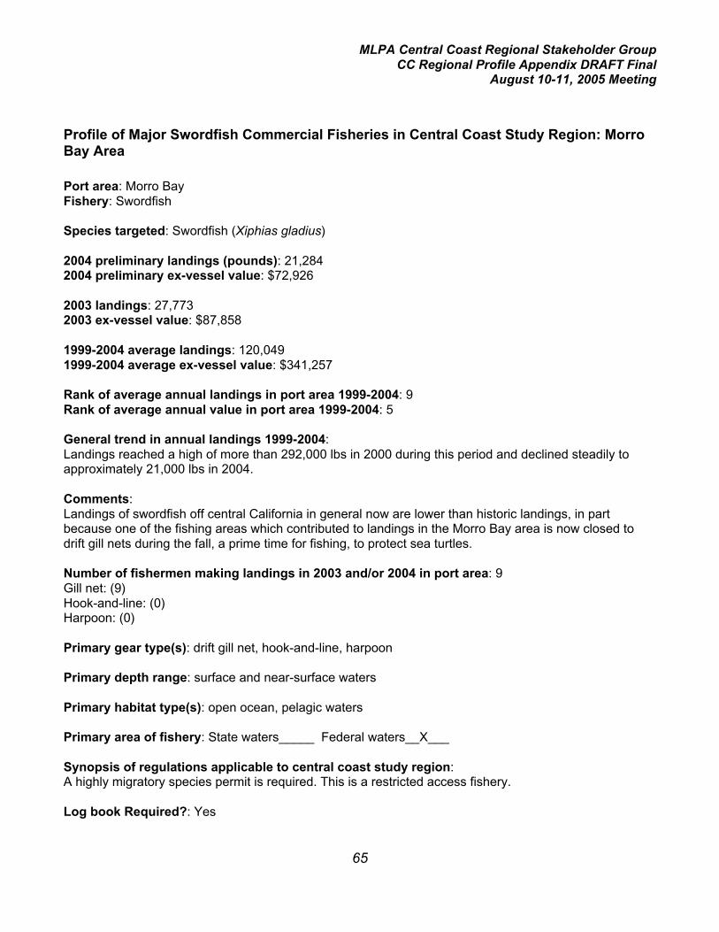
MLPA Central Coast Regional Stakeholder GroupCC Regional Profile Appendix DRAFT Final
August 10-11, 2005 Meeting
65
Profile of Major Swordfish Commercial Fisheries in Central Coast Study Region: MorroBay Area
Port area: Morro BayFishery: Swordfish
Species targeted: Swordfish (Xiphias gladius)
2004 preliminary landings (pounds): 21,2842004 preliminary ex-vessel value: $72,926
2003 landings: 27,7732003 ex-vessel value: $87,858
1999-2004 average landings: 120,0491999-2004 average ex-vessel value: $341,257
Rank of average annual landings in port area 1999-2004: 9Rank of average annual value in port area 1999-2004: 5
General trend in annual landings 1999-2004:Landings reached a high of more than 292,000 lbs in 2000 during this period and declined steadily toapproximately 21,000 lbs in 2004.
Comments:Landings of swordfish off central California in general now are lower than historic landings, in partbecause one of the fishing areas which contributed to landings in the Morro Bay area is now closed todrift gill nets during the fall, a prime time for fishing, to protect sea turtles.
Number of fishermen making landings in 2003 and/or 2004 in port area: 9Gill net: (9)Hook-and-line: (0)Harpoon: (0)
Primary gear type(s): drift gill net, hook-and-line, harpoon
Primary depth range: surface and near-surface waters
Primary habitat type(s): open ocean, pelagic waters
Primary area of fishery: State waters_____ Federal waters__X___
Synopsis of regulations applicable to central coast study region:A highly migratory species permit is required. This is a restricted access fishery.
Log book Required?: Yes

MLPA Central Coast Regional Stakeholder GroupCC Regional Profile Appendix DRAFT Final
August 10-11, 2005 Meeting
66
Relevant spatially-explicit data concerning location of fishery:The fishery occurs primarily in federal waters. Coupled with the high mobility of the species involved,spatially explicit data will be of little value to the MLPA Initiative process.

MLPA Central Coast Regional Stakeholder GroupCC Regional Profile Appendix DRAFT Final
August 10-11, 2005 Meeting
67
Profile of Major Salmon Commercial Fisheries in Central Coast Study Region: MorroBay Area
Port area: Morro BayFishery: Salmon
Species targeted: king salmon (Chinook) (Oncorhynchus tshawytscha)
2004 preliminary landings (pounds): 63,7782004 preliminary ex-vessel value: $230,602
2003 landings: 21,4882003 ex-vessel value: $62,585
1999-2004 average landings: 117,6841999-2004 average ex-vessel value: $245,652
Rank of average annual landings in port area 1999-2004: 10Rank of average annual value in port area 1999-2004: 6
General trend in annual landings 1999-2004:Landings have varied by more than 10-fold during the period with no trend.
Comments:Landings are influenced by several important factors: 1) the availability of 3- and 4-year old fish fromthe Sacramento and San Joaquin River system runs; and 2) the length of the fishing season, whichmay be shortened to protect salmon from the Klamath River system,(Klamath River salmon may mixwith stocks from central California). When the Klamath River stocks are relatively low, the commercialseason is shorter statewide. When ocean salmon are more abundant in general, they may be moreavailable in the Morro Bay area and occasionally will be found in southern California as well.
Number of fishermen making landings in 2003 and/or 2004 in port area: 68
Primary gear type(s): troll hook-and-line
Primary depth range: fishery occurs from the surface to 50 fathoms although the bottom depth maygreatly exceed that.
Primary habitat type(s): pelagic, open ocean
Primary area of fishery: State waters__X___ Federal waters__X___
Synopsis of regulations applicable to central coast study region:The Morro Bay sub-region of the central coast study area lies entirely within one of the Pacific FisheryManagement Council’s (PFMC) salmon management areas (Pt. Sur to US/Mexican border).

MLPA Central Coast Regional Stakeholder GroupCC Regional Profile Appendix DRAFT Final
August 10-11, 2005 Meeting
68
The fishing season varies each year, and is set by National Marine Fisheries Service underrecommendation of the PFMC. Considerations in shaping the chinook fisheries in this area include theprotection of Endangered Species Act-listed Sacramento River winter and California coastal chinook,and achievement of fall chinook spawning escapement goals for the Klamath, Sacramento, and Oregoncoastal rivers. California commercial seasons are based on preseason forecasts of ocean abundancesof Klamath fall chinook by age and estimates of total California Central Valley fall chinook adultabundance. The commercial season may not open in this area earlier than May 1 and closes no laterthan September 30. In 2005, the season is open May 1-31, July 4- August 29, and September 1-30.
In 2005 minimum legal length is 27 inches in May and September, and 28 inches in July and August.
Single point, barbless hooks are required. No more than six fishing lines are allowed per vessel.
There are no closed areas within the study region other than existing State Marine Reserves.
Coho salmon may not be taken.
Log book Required?: No
Relevant spatially-explicit data concerning location of fishery:Due to the combination of the high mobility of salmon, its widespread range, and its inter- and intra-annual variability in distribution, spatially explicit data will be less important to the MLPA Initiativeprocess than that from other fisheries.

MLPA Central Coast Regional Stakeholder GroupCC Regional Profile Appendix DRAFT Final
August 10-11, 2005 Meeting
69
Profile of Major Rock Crab Commercial Fisheries in Central Coast Study Region: MorroBay Area
Port area: Morro BayFishery: Rock crab
Species targeted:Brown rock crab (Cancer antennarius)Red rock crab (C. productus)Other species landed infrequently in port area:Yellow rock crab (C. anthonyi)
2004 preliminary landings (pounds): 48,3312004 preliminary ex-vessel value: $110,342
2003 landings: 56,8312003 ex-vessel value: $73,931
1999-2004 average landings: 82,6051999-2004 average ex-vessel value: $115,553
Rank of average annual landings in port area 1999-2004: 12Rank of average annual value in port area 1999-2004: 14
General trend in annual landings 1999-2004:Landings were fairly stable through 2002 but have declined by more than 50% since then.
Comments:Most of the rock crab landed in the Morro Bay port area originate from south of the central coast studyregion, primarily the northern Santa Barbara Channel Islands and the mainland coastal waters of SantaBarbara County. The established presence of the southern sea otter effectively precludes a commercialor recreational fishery in the Morro Bay port area. The decline in recent landings is due primarily to adecrease in fishing effort.
Number of fishermen making landings in 2003 and/or 2004 in port area: 19
Primary gear type(s): Rectangular traps, which are usually set individually (rarely in pairs), with a lineand marker buoy.
Primary depth range: 7- 30 fathoms
Primary habitat type(s): kelp bed areas, rocky reefs, mixed substrate, sand bottom.
Primary area of fishery: State waters__X___ Federal waters_____
Synopsis of regulations applicable to central coast study region:
Minimum carapace width of 4.25 inches.

MLPA Central Coast Regional Stakeholder GroupCC Regional Profile Appendix DRAFT Final
August 10-11, 2005 Meeting
70
Rectangular traps of 2” X 4” or 2” X 2” wire mesh, with 1 or 2 escape port(s) (depending on mesh size)and at least one approved self-destruct device are predominantly used. Molded plastic traps are usedby some fishermen.
Permit system: A permit system and a control date were initiated in the 2005-2006 fishing season. ANorthern Rock Crab Trap Permit is required north of Lopez Point in Monterey County, and a SouthernRock Crab Trap Permit south of that point. The fee for either permit is $250, but there is qualifyinglanding criteria that the applicant must meet to purchase a southern permit.
Log book Required?: No
Relevant spatially-explicit data concerning location of fishery:EcoTrust will provide information on the distribution of fishing effort.

MLPA Central Coast Regional Stakeholder GroupCC Regional Profile Appendix DRAFT Final
August 10-11, 2005 Meeting
71
Profile of Major Spot Prawn Trap Commercial Fisheries in Central Coast Study Region:Morro Bay Area
Port area: Morro BayFishery: Spot Prawn Trap
Species targeted: Spot prawn (Pandalus platyceros)
2004 landings (pounds): 11,5512004 ex-vessel value: $120,245
2003 landings: 5,2252003 ex-vessel value: $51,530
1999-2004 average landings: 74,8141999-2004 average ex-vessel value: $604,549
Rank of average annual landings in port area 1999-2004: 14Rank of average annual value in port area 1999-2004: 1
General trend in annual landings 1999-2004: Landings in the port area peaked in 2000 when a trawlfishery operated in the same area as the trap fishery.
Comments: The harvest of spot prawns using trawl gear was prohibited beginning in 2003. A relativelysmall number of trap fishermen operate in the Morro Bay area, but with a significant harvest. Additionaleffort is possible beginning in 2005 because the Fish and Game Commission approved up to 11 trawl-to-trap“conversion” permits statewide at the end of 2004 for former spot prawn trawl fishermen (ninewere purchased). Spot prawns change sex from male to female at age 3; thus the larger prawns are allfemale. Spot prawns are maintained in tanks on board before landing and sold in a live condition for$10.00 –$13.50/pound.
Number of fishermen making landings in 2003 and/or 2004 in port area: 2
Primary gear type(s): Plastic or wire mesh traps with a minimum mesh size of 7/8 by 7/8 inches. Thetraps are set in strings marked with a buoy at each end.
Primary depth range: 100 -150 fathoms
Primary habitat type(s): submarine canyon; hard, soft, and mixed bottom
Primary area of fishery: State waters__X__ Federal waters__X__

MLPA Central Coast Regional Stakeholder GroupCC Regional Profile Appendix DRAFT Final
August 10-11, 2005 Meeting
72
Synopsis of regulations applicable to central coast study region:Restricted access fishery with a 3-tier structure. Total of 29 (17 + 3 + 9) permits statewide with norestrictions on geographical region of fishing.
Tier 1 permits (17) are fully transferable. A permittee may use no more than 500 traps (only 300 in statewaters north of Pt. Arguello), and has no restrictions on landings.
Tier 2 permits (3) are not transferable. A permittee may use no more than 150 traps, and may land nomore than 5,000 pounds of spot prawns in a calendar year.
Tier 3 (trawl-to-trap conversion) permits (9) are not transferable. A permittee may use no more than 500traps (only 300 in state waters north of Pt. Arguello), and has no restrictions on landings.
Closed season north of Pt. Arguello is May 1 to July 31. Closed season south of Pt. Arguello isNovember 1 to January 31.
All species caught incidentally in spot prawn traps must be returned to the water immediately.
Log book Required?: Yes
Relevant spatially-explicit data concerning location of fishery:EcoTrust will provide information on the distribution of fishing effort.In addition, relative fishing effort by DFG fishing block is available for 1998-99. These years are beforethe restricted access fishery began and before the trawl closure was established and thus provide abetter picture of the distribution of the resource.

MLPA Central Coast Regional Stakeholder GroupCC Regional Profile Appendix DRAFT Final
August 10-11, 2005 Meeting
73
Profile of Major Shelf Rockfish Commercial Fisheries in Central Coast Study Region:Morro Bay Area
Port area: Morro BayFishery: Shelf rockfish
Species targeted: shelf rockfishes: bocaccio (Sebastes paucispinis), canary (S. pinniger), chilipepper(S. goodei), shortbelly (S. jordani), widow (S. entomelas), and yelloweye (S. ruberrimus)Other species landed: shelf rockfishes: bronzespotted (S. gilli), cowcod (S. levis), flag (S. rubrivinctus),greenblotched (S. rosenblatti), greenspotted (S. chlorostictus), greenstriped (S. elongatus), halfbanded(S. semicinctus), pink (S. eos), pinkrose (S. simulator), redstripe (S. proriger), rosethorn (S.helvomaculatus), rosy (S. rosaceus), speckled (S. ovalis), squarespot (S. hopkinsi), starry (S.constellatus), stripetail (S. saxicola), swordspine (S. ensifer), tiger (S. nigrocinctus), vermilion (S.miniatus), yellowtail (S. flavidus)
2004 preliminary landings (pounds): 12,2382004 preliminary ex-vessel value: $19,802
2003 landings: 9,5022003 ex-vessel value: $12,342
1999-2004 average landings: 45,1371999-2004 average ex-vessel value: $29,237
Rank of average annual landings in port area 1999-2004: 15Rank of average annual value in port area 1999-2004: 20
General trend in annual landings 1999-2004:Beginning in 2001 landings have been only 15 to 30% of those in 1999.
Comments: This significant decline in landings was due primarily to the establishment of the RockfishConservation Area (RCA), a fishery management closure designed to help rebuild overfished stocks ofthe following rockfishes: bocaccio, canary, cowcod, darkblotched, Pacific ocean perch, widow, andyelloweye. Many other rockfish species associated with these overfished species, and the relativelysmall landings for shelf rockfish in general originate from outside of the RCA. However, the average ex-vessel value increased significantly in 2003-2004 compared with earlier years due to the higher marketvalue of hook-and-line caught fish.
Number of fishermen making landings in 2003 and/or 2004 in port area:Hook-and-line: 76Trawl: 4Gill net: 1
Primary gear type(s): bottom trawl, midwater trawl, longline, hook-and-line, gill net
Primary depth range: 30-200 fathoms

MLPA Central Coast Regional Stakeholder GroupCC Regional Profile Appendix DRAFT Final
August 10-11, 2005 Meeting
74
Primary habitat type(s): deep rocky reefs, mixed-bottom substrate including cobble and sand, edgesof submarine canyons
Primary area of fishery: State waters__X___ Federal waters__X___
Synopsis of regulations applicable to central coast study region:Within the Rockfish Conservation Area (RCA), the taking of rockfishes, lingcod, California scorpionfish,and ocean whitefish is prohibited. Within the central coast study region (Pigeon Pt. to Pt. Conception),the RCA for commercial fishing is 20 to 150 fathoms for fixed gears (limited entry and open access) andfrom 75 to 150 fathoms for trawlers.
Trawling for rockfishes is prohibited within 3 miles of shore
Gill netting for rockfishes is prohibited in state waters.
A federal permit is required to fish outside of the RCA. There are four types of federal permits: trawllimited entry, trawl open access, fixed gear limited entry, non-trawl open access.
Annual harvest limits and two-month trip limits are in effect, with a total closure on cowcod by trawl gearand for canary and yelloweye rockfishes and cowcod by fixed gears.
Small footrope trawl gear is required shoreward of the RCA.
Rockfishes landed must be sorted by species or species group prior to weighing.
Log book Required?: Yes for trawling
Relevant spatially-explicit data concerning location of fishery:EcoTrust will provide information on the distribution of non-trawl fishing effort. Trawl tows recorded onlogbooks have been compiled (assuming straight-line tows between start and end points) from 1997 to2003 and will be available as a GIS data layer.

MLPA Central Coast Regional Stakeholder GroupCC Regional Profile Appendix DRAFT Final
August 10-11, 2005 Meeting
75
Profile of Major California Halibut Commercial Fisheries in Central Coast Study Region:Morro Bay Area
Port area: Morro BayFishery: California halibut
Species targeted: California halibut (Paralichthys californicus)
2004 preliminary landings (pounds): 5,0862004 preliminary ex-vessel value: $16,369
2003 landings: 10,5142003 ex-vessel value: $29,384
1999-2004 average landings: 35,6331999-2004 average ex-vessel value: $92,944
Rank of average annual landings in port area 1999-2004: 17Rank of average annual value in port area 1999-2004: 15
General trend in annual landings 1999-2004:Landings have declined steadily from approximately 63,000 lbs in 2001 to approximately 5,000 lbs in2004.
Comments: The number of gillnet boats making at least one halibut landing in the Morro Bay areadecreased from a high of 13 in 2001 to only one in 2003 and 2004, primarily due to increasedrestrictions on the use of this gear. This, coupled along with a reduction of trawlers (17 in 1999 to a lowof four in 2004), accounts for the substantial decrease. Market conditions have developed such thattrawling for halibut is not as economically feasible as it was in the past, and some of the major trawlvessels have left the fishery.
Number of fishermen making landings in 2003 and/or 2004 in port area:Trawl: 9Hook-and-line: 38Gill or trammel net: 1
Primary gear type(s): trawl, hook-and-line, gill and trammel net
Primary depth range: 2 – 50 fathoms
Primary habitat type(s): sand bottom
Primary area of fishery: State waters__X___ Federal waters__X___

MLPA Central Coast Regional Stakeholder GroupCC Regional Profile Appendix DRAFT Final
August 10-11, 2005 Meeting
76
Synopsis of regulations applicable to central coast study region:The Fish and Game Commission has authority over state-managed bottom trawl fisheries not managedunder federal regulations, which includes regulations pertaining to California halibut.
Trawling for halibut is prohibited within 3 miles of shore, except in the area from Pt. Arguello south toPt. Mugu greater than 1 nautical mile from shore.Minimum mesh size for trawls in this area is 7.5 inches, and trawling is closed from March 15 to June15.
In waters greater than 3 nautical miles from shore, trawling is permitted, and minimum mesh size is 4.5inches.
Gill and trammel nets are prohibited in waters less than 60 fathoms deep from Pt. Reyes headlands inMarin county south to Pt. Arguello.
Where gill nets and trammel nets are legal, minimum mesh size is 8.5 inches. Gill and trammel netsmay not exceed 1,500 fathoms (9,000 feet) in length, except that in a portion of southern Californiasouth of a line extending due west from Pt. Arguello, gill and trammel nets may not exceed 1,000fathoms (6,000 feet).
Halibut less than 22 inches may not be taken, possessed, or sold unless it weighs 4 lbs or more in theround, 3.5 lbs or more dressed with head on, or 3 lbs or more dressed with head off.
Log book Required?: Yes for trawlers – when/where fishing is permitted
Relevant spatially-explicit data concerning location of fishery:EcoTrust will provide information on the distribution of non-trawl fishing effort.

MLPA Central Coast Regional Stakeholder GroupCC Regional Profile Appendix DRAFT Final
August 10-11, 2005 Meeting
77
Profile of Major Shark Commercial Fisheries in Central Coast Study Region: Morro BayArea
Port area: Morro BayFishery: Shark (this represents multiple fisheries which either target shark or harvest them incidentally)
Species targeted: thresher shark (Alopias vulpinus), shortfin mako shark (bonito shark) (Isurusoxyrinchus), spiny dogfish (Squalus acanthias), soupfin shark (Galeorhinus zyopterus)Other species landed: brown smoothhound (Mustelus henlei), leopard shark (Triakis semifasciata),Pacific angel shark (Squatina californica)
2004 preliminary landings (pounds): 19,1442004 preliminary ex-vessel value: $18,308
2003 landings: 16,2492003 ex-vessel value: $17,998
1999-2004 average landings: 23,6281999-2004 average ex-vessel value:$22,440
Rank of average annual landings in port area 1999-2004: 18Rank of average annual value in port area 1999-2004: 23
General trend in annual landings 1999-2004:Landings have varied by approximately two-fold during the period, with the latter 3 years showing lowerlandings.
Comments:Thresher shark has consistently been the number one species landed. Mako shark landings havedeclined steadily from more than 8,000 lbs in 1999 to less than 1,500 lbs in 2004. Soupfin sharklandings have declined significantly from almost 8,000 lbs in 2001 to 400 pounds in 2004. Pacific angelshark has followed a similar trend. Spiny dogfish are a much less important component of sharklandings compared with the Monterey area.
Number of fishermen making landings in 2003 and/or 2004 in port area:Hook-and-line: 14Gill net: 11Trawl: 5
Primary gear type(s):Hook-and-lineDrift gill net (primarily for thresher and shortfin mako sharks)Set gill net or trammel net (primarily for Pacific angel sharks)Trawl (primarily for spiny dogfish)
Primary depth range: 0 to 400 fathoms
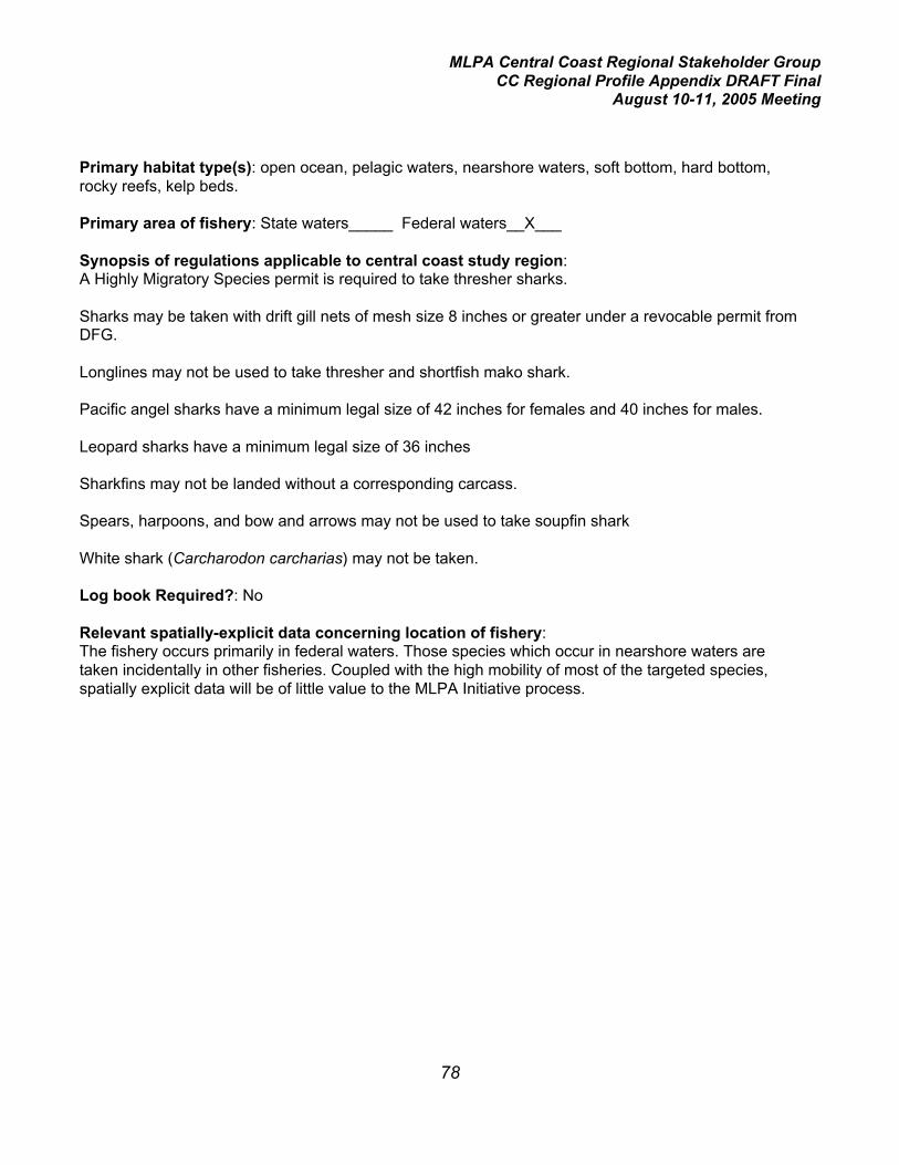
MLPA Central Coast Regional Stakeholder GroupCC Regional Profile Appendix DRAFT Final
August 10-11, 2005 Meeting
78
Primary habitat type(s): open ocean, pelagic waters, nearshore waters, soft bottom, hard bottom,rocky reefs, kelp beds.
Primary area of fishery: State waters_____ Federal waters__X___
Synopsis of regulations applicable to central coast study region:A Highly Migratory Species permit is required to take thresher sharks.
Sharks may be taken with drift gill nets of mesh size 8 inches or greater under a revocable permit fromDFG.
Longlines may not be used to take thresher and shortfish mako shark.
Pacific angel sharks have a minimum legal size of 42 inches for females and 40 inches for males.
Leopard sharks have a minimum legal size of 36 inches
Sharkfins may not be landed without a corresponding carcass.
Spears, harpoons, and bow and arrows may not be used to take soupfin shark
White shark (Carcharodon carcharias) may not be taken.
Log book Required?: No
Relevant spatially-explicit data concerning location of fishery:The fishery occurs primarily in federal waters. Those species which occur in nearshore waters aretaken incidentally in other fisheries. Coupled with the high mobility of most of the targeted species,spatially explicit data will be of little value to the MLPA Initiative process.

MLPA Central Coast Regional Stakeholder GroupCC Regional Profile Appendix DRAFT Final
August 10-11, 2005 Meeting
79
Profile of Major Lingcod Commercial Fisheries in Central Coast Study Region: MorroBay Area
Port area: Morro BayFishery: Lingcod
Species targeted: Lingcod (Ophiodon elongatus). Lingcod are generally not specifically targeted butare so widespread that they are caught in most hard-bottom oriented fisheries targeting rockfishes,cabezon, and other species.
2004 preliminary landings (pounds): 25,0412004 preliminary ex-vessel value: $39,883
2003 landings: 20,7142003 ex-vessel value: $35,218
1999-2004 average landings: 18,6711999-2004 average ex-vessel value: $28,635
Rank of average annual landings in port area 1999-2004: 19Rank of average annual value in port area 1999-2004: 21
General trend in annual landings 1999-2004:Landings have varied by approximately four- to five-fold with no trend.
Comments:Prior to 1999, the Acceptable Biological Catch for lingcod set by the National Marine Fisheries Servicehad undergone a series of significant reductions, and regional and statewide landings are substantiallylower in this recent 6-year period compared with the previous two decades. Lingcod is now officiallydeclared to be an overfished species; a rebuilding plan is implemented and allowable harvest levels arerelatively low.
Number of fishermen making landings in 2003 and/or 2004 in port area:Hook-and-line: 88Trawl: 11Trap: 16Gill net: 1
Primary gear type(s):Hook-and-lineTrawlGill netTrap
Primary depth range: 2- 200 fathoms
Primary habitat type(s): deep and shallow rocky reef, kelp beds, low- to high-relief mixed substrateand hard bottom, submarine canyons.
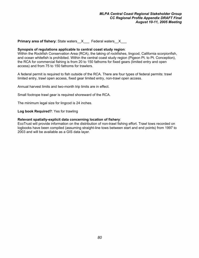
MLPA Central Coast Regional Stakeholder GroupCC Regional Profile Appendix DRAFT Final
August 10-11, 2005 Meeting
80
Primary area of fishery: State waters__X___ Federal waters__X___
Synopsis of regulations applicable to central coast study region:Within the Rockfish Conservation Area (RCA), the taking of rockfishes, lingcod, California scorpionfish,and ocean whitefish is prohibited. Within the central coast study region (Pigeon Pt. to Pt. Conception),the RCA for commercial fishing is from 20 to 150 fathoms for fixed gears (limited entry and openaccess) and from 75 to 150 fathoms for trawlers.
A federal permit is required to fish outside of the RCA. There are four types of federal permits: trawllimited entry, trawl open access, fixed gear limited entry, non-trawl open access.
Annual harvest limits and two-month trip limits are in effect.
Small footrope trawl gear is required shoreward of the RCA.
The minimum legal size for lingcod is 24 inches.
Log book Required?: Yes for trawling
Relevant spatially-explicit data concerning location of fishery:EcoTrust will provide information on the distribution of non-trawl fishing effort. Trawl tows recorded onlogbooks have been compiled (assuming straight-line tows between start and end points) from 1997 to2003 and will be available as a GIS data layer.

MLPA Central Coast Regional Stakeholder GroupCC Regional Profile Appendix DRAFT Final
August 10-11, 2005 Meeting
81
Profile of Major Dungeness Crab Commercial Fisheries in Central Coast Study Region:Morro Bay Area
Port area: Morro BayFishery: Dungeness Crab
Species targeted: Dungeness crab (Cancer magister)
2004 preliminary landings (pounds): 23,0642004 preliminary ex-vessel value: $72,854
2003 landings: 30,3572003 ex-vessel value: $91,670
1999-2004 average landings: 16,8121999-2004 average ex-vessel value: $57,524
Rank of average annual landings in port area 1999-2004: 20Rank of average annual value in port area 1999-2004: 16
General trend in annual landings 1999-2004:Landings increased dramatically from 1999 to 2002 then declined by more than 50%.
Comments: Landings in northern California have experienced repeated cycles at approximately 10-year intervals. Central California landings have been less cyclical but still highly variable. Due to heavyfishing pressure in the beginning of each season, the majority of the annual landings typically occurduring the first two months of the season. The primary fishing grounds are generally considered to benorth of the Monterey port area, but this fishery can be relatively important locally in some years.
Number of fishermen making landings in 2003 and/or 2004 in port area: 13
Primary gear type(s): Circular traps, each attached to a separate line and buoy.
Primary depth range: 0-50 fathoms
Primary habitat type(s): sand bottom
Primary area of fishery: State waters__X__ Federal waters__X__

MLPA Central Coast Regional Stakeholder GroupCC Regional Profile Appendix DRAFT Final
August 10-11, 2005 Meeting
82
Synopsis of regulations applicable to central coast study region:Closed season July 1 through November 14. Open season may be extended as late as July 31 byorder of DFG Director.
Minimum carapace width 6.25 inches.
Only males may be harvested.
This is a restricted access fishery with a vessel-based permit system.
There is no limit on the number of traps per vessel which may be used but legislation has beenintroduced to limit the maximum number of traps .
There are no closed areas other than as specified in particular MPAs.
Log book Required?: No
Relevant spatially-explicit data concerning location of fishery:EcoTrust will provide information on the distribution of fishing effort.

MLPA Central Coast Regional Stakeholder GroupCC Regional Profile Appendix DRAFT Final
August 10-11, 2005 Meeting
83
Profile of Major Surfperch Commercial Fisheries in Central Coast Study Region: MorroBay Area
Port area: Morro BayFishery: Surfperch
Species targeted: Barred surfperch (Amphistichus argenteus)Other species landed: Calico surfperch (Amphistichus koelzi); shiner surfperch (Cymatogasteraggregata)
2004 preliminary landings (pounds): 25,5652004 preliminary ex-vessel value: $51,286
2003 landings: 24,0392003 ex-vessel value: $48,254
1999-2004 average landings: 15,2461999-2004 average ex-vessel value: $29,719
Rank of average annual landings in port area 1999-2004: 21Rank of average annual value in port area 1999-2004: 19
General trend in annual landings 1999-2004:Landings have increased steadily from approximately 9,000 lbs in 1999 to more than 25,000 lbs in2004.
Comments:With an average ex-vessel value of approximately $2.00 per pound, this fishery has seen an increase ineffort in recent years in the Morro Bay area.
Number of fishermen making landings in 2003 and/or 2004 in port area: 66
Primary gear type(s): hook-and-line
Primary depth range: 0 – 10 fathoms
Primary habitat type(s): sand bottom, exposed beaches
Primary area of fishery: State waters__X___ Federal waters_____
Synopsis of regulations applicable to central coast study region:Fishing season is closed May 1 through July 31 for all species except shiner surfperch, which may betaken year-round.
South of Pt. Arguello, barred, redtail (Amphisticus rhodoterus) (not found in Morro Bay area), and calicosurfperch may not be taken.
Log book Required?: No

MLPA Central Coast Regional Stakeholder GroupCC Regional Profile Appendix DRAFT Final
August 10-11, 2005 Meeting
84
Relevant spatially-explicit data concerning location of fishery:EcoTrust will provide information on the distribution of fishing effort.
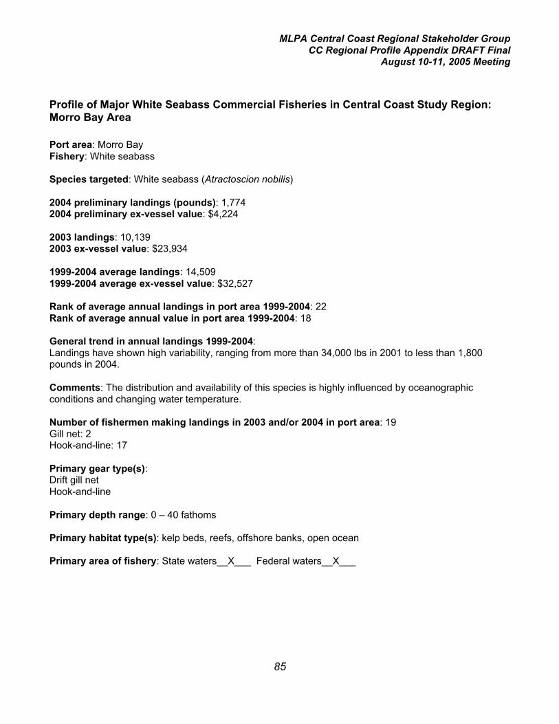
MLPA Central Coast Regional Stakeholder GroupCC Regional Profile Appendix DRAFT Final
August 10-11, 2005 Meeting
85
Profile of Major White Seabass Commercial Fisheries in Central Coast Study Region:Morro Bay Area
Port area: Morro BayFishery: White seabass
Species targeted: White seabass (Atractoscion nobilis)
2004 preliminary landings (pounds): 1,7742004 preliminary ex-vessel value: $4,224
2003 landings: 10,1392003 ex-vessel value: $23,934
1999-2004 average landings: 14,5091999-2004 average ex-vessel value: $32,527
Rank of average annual landings in port area 1999-2004: 22Rank of average annual value in port area 1999-2004: 18
General trend in annual landings 1999-2004:Landings have shown high variability, ranging from more than 34,000 lbs in 2001 to less than 1,800pounds in 2004.
Comments: The distribution and availability of this species is highly influenced by oceanographicconditions and changing water temperature.
Number of fishermen making landings in 2003 and/or 2004 in port area: 19Gill net: 2Hook-and-line: 17
Primary gear type(s):Drift gill netHook-and-line
Primary depth range: 0 – 40 fathoms
Primary habitat type(s): kelp beds, reefs, offshore banks, open ocean
Primary area of fishery: State waters__X___ Federal waters__X___

MLPA Central Coast Regional Stakeholder GroupCC Regional Profile Appendix DRAFT Final
August 10-11, 2005 Meeting
86
Synopsis of regulations applicable to central coast study region:There is a closed season south of Pt. Conception from March 15 to June 15, with an allowance for fishtaken incidental to gill and trammel net fishing.
There is a minimum legal size of 28 inches.
Mesh size of gill nets must be not less than 6 inches.
White seabass may not be taken in roundhaul nets.
Log book Required?: Yes for gill net
Relevant spatially-explicit data concerning location of fishery:EcoTrust will provide information on the distribution of fishing effort.

MLPA Central Coast Regional Stakeholder GroupCC Regional Profile Appendix DRAFT Final
August 10-11, 2005 Meeting
87
Profile of Major Red Urchin Commercial Fisheries in Central Coast Study Region: MorroBay Area
Port area: Morro BayFishery: red urchin
Species targeted: red urchin (Strongylocentrotus franciscanus)
2004 preliminary landings (pounds): 18,3492004 preliminary ex-vessel value: $14,660
2003 landings: 31,5862003 ex-vessel value: $24,332
1999-2004 average landings: 13,7091999-2004 average ex-vessel value: $11,321
Rank of average annual landings in port area 1999-2004: 23Rank of average annual value in port area 1999-2004: 25
General trend in annual landings 1999-2004:Landings have been highly variable, from 0 lbs to more than 31,000 pounds, and have been aboveaverage for the last three years of this six-year period.
Comments: The red urchins landed in the Morro Bay port area are harvested outside of the centralcoast study region, primarily from the northern Channel Islands. Southern California landings in generaldeclined steadily from 1990 to 1999; urchin abundance and availability are influenced by El Niño eventsand a weakening Japanese currency.
Number of fishermen making landings in 2003 and/or 2004 in port area: 2
Primary gear type(s): hand harvest using rakes, with scuba or hookah gear
Primary depth range: 2 -15 fathoms
Primary habitat type(s): shallow rocky reefs, kelp beds, hard bottom
Primary area of fishery: State waters__X___ Federal waters_____

MLPA Central Coast Regional Stakeholder GroupCC Regional Profile Appendix DRAFT Final
August 10-11, 2005 Meeting
88
Synopsis of regulations applicable to central coast study region:This is a restricted access fishery with an urchin diving permit required. There are no landingrequirements to renew the permit.
The season is open 7 days per week from November 1 through March 31. The season is open 4 days aweek in April, May, September and October, 3 days a week in June and August, and 2 days a week inJuly.
Urchins harvested south of the Monterey-San Luis Obispo County line may not have a test diameterbetween 1_ and 3_ inches, except that not more than 30 may be landed incidentally within this sizerange. (Urchins less than 1_ inches in diameter are not targeted, but are often landed incidentally asthey typically use the spine canopies of larger urchins as shelter.
Log book Required?: Yes
Relevant spatially-explicit data concerning location of fishery:The fishery occurs outside of the central coast study region. Thus there are no spatial data relevant tothe MLPA Initiative process.

MLPA Central Coast Regional Stakeholder GroupCC Regional Profile Appendix DRAFT Final
August 10-11, 2005 Meeting
I
Appendix III: Profile of Major Recreational Fisheries in the Central Coast Study Region
Contents
1. Profile of Major Recreational Fisheries in the Central Coast Study Region: ByCommercial Passenger Fishing Vessel
4. Profile of Major Recreational Fisheries in the Central Coast Study Region:Private and Rental Skiff Fishing
7. Profile of Major Recreational Fisheries in the Central Coast Study Region: Bankand Beach Fishing
9. Profile of Major Recreational Fisheries in the Central Coast Study Region:Fishing from manmade structures
12. Profile of Major Recreational Fisheries in the Central Coast Study Region: Bankand Beach Fishing
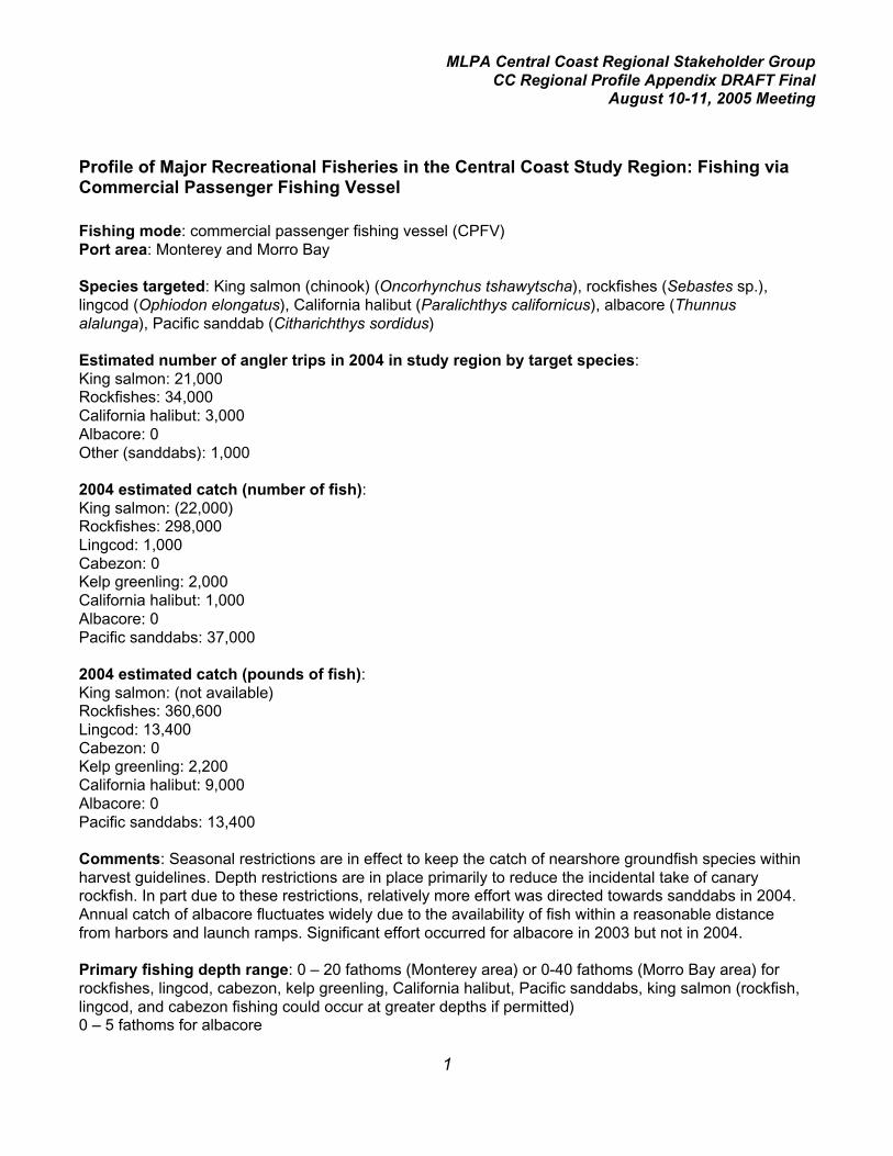
MLPA Central Coast Regional Stakeholder GroupCC Regional Profile Appendix DRAFT Final
August 10-11, 2005 Meeting
1
Profile of Major Recreational Fisheries in the Central Coast Study Region: Fishing viaCommercial Passenger Fishing Vessel
Fishing mode: commercial passenger fishing vessel (CPFV)Port area: Monterey and Morro Bay
Species targeted: King salmon (chinook) (Oncorhynchus tshawytscha), rockfishes (Sebastes sp.),lingcod (Ophiodon elongatus), California halibut (Paralichthys californicus), albacore (Thunnusalalunga), Pacific sanddab (Citharichthys sordidus)
Estimated number of angler trips in 2004 in study region by target species:King salmon: 21,000Rockfishes: 34,000California halibut: 3,000Albacore: 0Other (sanddabs): 1,000
2004 estimated catch (number of fish):King salmon: (22,000)Rockfishes: 298,000Lingcod: 1,000Cabezon: 0Kelp greenling: 2,000California halibut: 1,000Albacore: 0Pacific sanddabs: 37,000
2004 estimated catch (pounds of fish):King salmon: (not available)Rockfishes: 360,600Lingcod: 13,400Cabezon: 0Kelp greenling: 2,200California halibut: 9,000Albacore: 0Pacific sanddabs: 13,400
Comments: Seasonal restrictions are in effect to keep the catch of nearshore groundfish species withinharvest guidelines. Depth restrictions are in place primarily to reduce the incidental take of canaryrockfish. In part due to these restrictions, relatively more effort was directed towards sanddabs in 2004.Annual catch of albacore fluctuates widely due to the availability of fish within a reasonable distancefrom harbors and launch ramps. Significant effort occurred for albacore in 2003 but not in 2004.
Primary fishing depth range: 0 – 20 fathoms (Monterey area) or 0-40 fathoms (Morro Bay area) forrockfishes, lingcod, cabezon, kelp greenling, California halibut, Pacific sanddabs, king salmon (rockfish,lingcod, and cabezon fishing could occur at greater depths if permitted)0 – 5 fathoms for albacore
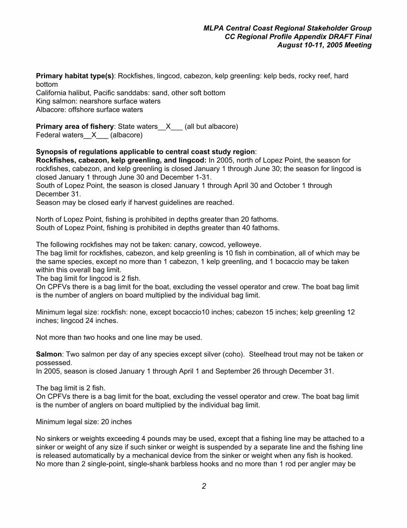
MLPA Central Coast Regional Stakeholder GroupCC Regional Profile Appendix DRAFT Final
August 10-11, 2005 Meeting
2
Primary habitat type(s): Rockfishes, lingcod, cabezon, kelp greenling: kelp beds, rocky reef, hardbottomCalifornia halibut, Pacific sanddabs: sand, other soft bottomKing salmon: nearshore surface watersAlbacore: offshore surface waters
Primary area of fishery: State waters__X___ (all but albacore)Federal waters__X___ (albacore)
Synopsis of regulations applicable to central coast study region:Rockfishes, cabezon, kelp greenling, and lingcod: In 2005, north of Lopez Point, the season forrockfishes, cabezon, and kelp greenling is closed January 1 through June 30; the season for lingcod isclosed January 1 through June 30 and December 1-31.South of Lopez Point, the season is closed January 1 through April 30 and October 1 throughDecember 31.Season may be closed early if harvest guidelines are reached.
North of Lopez Point, fishing is prohibited in depths greater than 20 fathoms.South of Lopez Point, fishing is prohibited in depths greater than 40 fathoms.
The following rockfishes may not be taken: canary, cowcod, yelloweye.The bag limit for rockfishes, cabezon, and kelp greenling is 10 fish in combination, all of which may bethe same species, except no more than 1 cabezon, 1 kelp greenling, and 1 bocaccio may be takenwithin this overall bag limit.The bag limit for lingcod is 2 fish.On CPFVs there is a bag limit for the boat, excluding the vessel operator and crew. The boat bag limitis the number of anglers on board multiplied by the individual bag limit.
Minimum legal size: rockfish: none, except bocaccio10 inches; cabezon 15 inches; kelp greenling 12inches; lingcod 24 inches.
Not more than two hooks and one line may be used.
Salmon: Two salmon per day of any species except silver (coho). Steelhead trout may not be taken orpossessed.In 2005, season is closed January 1 through April 1 and September 26 through December 31.
The bag limit is 2 fish.On CPFVs there is a bag limit for the boat, excluding the vessel operator and crew. The boat bag limitis the number of anglers on board multiplied by the individual bag limit.
Minimum legal size: 20 inches
No sinkers or weights exceeding 4 pounds may be used, except that a fishing line may be attached to asinker or weight of any size if such sinker or weight is suspended by a separate line and the fishing lineis released automatically by a mechanical device from the sinker or weight when any fish is hooked.No more than 2 single-point, single-shank barbless hooks and no more than 1 rod per angler may be
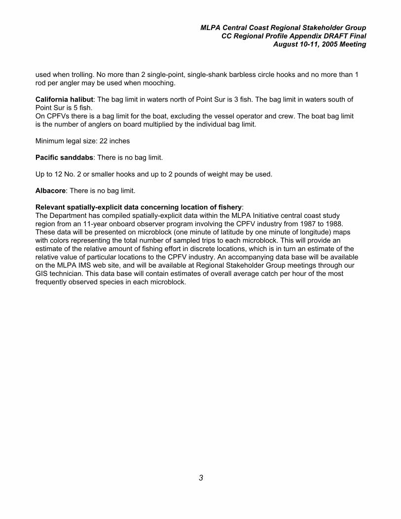
MLPA Central Coast Regional Stakeholder GroupCC Regional Profile Appendix DRAFT Final
August 10-11, 2005 Meeting
3
used when trolling. No more than 2 single-point, single-shank barbless circle hooks and no more than 1rod per angler may be used when mooching.
California halibut: The bag limit in waters north of Point Sur is 3 fish. The bag limit in waters south ofPoint Sur is 5 fish.On CPFVs there is a bag limit for the boat, excluding the vessel operator and crew. The boat bag limitis the number of anglers on board multiplied by the individual bag limit.
Minimum legal size: 22 inches
Pacific sanddabs: There is no bag limit.
Up to 12 No. 2 or smaller hooks and up to 2 pounds of weight may be used.
Albacore: There is no bag limit.
Relevant spatially-explicit data concerning location of fishery:The Department has compiled spatially-explicit data within the MLPA Initiative central coast studyregion from an 11-year onboard observer program involving the CPFV industry from 1987 to 1988.These data will be presented on microblock (one minute of latitude by one minute of longitude) mapswith colors representing the total number of sampled trips to each microblock. This will provide anestimate of the relative amount of fishing effort in discrete locations, which is in turn an estimate of therelative value of particular locations to the CPFV industry. An accompanying data base will be availableon the MLPA IMS web site, and will be available at Regional Stakeholder Group meetings through ourGIS technician. This data base will contain estimates of overall average catch per hour of the mostfrequently observed species in each microblock.

MLPA Central Coast Regional Stakeholder GroupCC Regional Profile Appendix DRAFT Final
August 10-11, 2005 Meeting
4
Profile of Major Recreational Fisheries in the Central Coast Study Region: Private andRental Skiff Fishing
Fishing mode: private and rental skiffPort area: Monterey and Morro Bay
Species targeted: King salmon (chinook) (Oncorhynchus tshawytscha), rockfishes (Sebastes sp.),lingcod (Ophiodon elongatus), California halibut (Paralichthys californicus), albacore (Thunnusalalunga), Pacific sanddab (Citharichthys sordidus)
Estimated number of fishing trips in 2004 in study region by target species:King salmon: 32,000Rockfishes: 18,000Lingcod: 3,000California halibut: 8,000Albacore: 1,000Other: 5,000Anything: 3,000
2004 estimated catch (number of fish):King salmon: (22,000)Rockfishes: 110,000Lingcod: 3,000Cabezon: 1,000Kelp greenling: 1,000California halibut: 2,000Albacore: 1,000Pacific sanddabs: 100,000
2004 estimated catch (pounds of fish):King salmon: (not available)Rockfishes: 170,200Lingcod: 29,100Cabezon: 4,500Kelp greenling: 1,500California halibut: 26,9000Albacore: 24,600Pacific sanddabs: 33,600
Comments: Seasonal restrictions are in effect to keep the catch of nearshore groundfish species withinharvest guidelines. Depth restrictions are in place primarily to reduce the incidental take of canaryrockfish. In part due to these restrictions, relatively more effort was directed towards sanddabs in 2004.Annual catch of albacore fluctuates widely due to the availability of fish within a reasonable distancefrom harbors and launch ramps. The 2004 albacore catch was much lower than that in 2003.

MLPA Central Coast Regional Stakeholder GroupCC Regional Profile Appendix DRAFT Final
August 10-11, 2005 Meeting
5
Primary fishing depth range: 0 – 20 fathoms (Monterey area) or 0-40 fathoms (Morro Bay area) forrockfishes, lingcod, cabezon, kelp greenling, California halibut, Pacific sanddabs, king salmon (rockfish,lingcod, and cabezon fishing could occur at greater depths if permitted)0 – 5 fathoms for albacore
Primary habitat type(s): Rockfishes, lingcod, cabezon, kelp greenling: kelp beds, rocky reef, hardbottomCalifornia halibut, Pacific sanddabs: sand, other soft bottomKing salmon: nearshore surface watersAlbacore: offshore surface waters
Primary area of fishery: State waters__X___ (all but albacore)Federal waters__X___ (albacore)
Synopsis of regulations applicable to central coast study region:Rockfishes, cabezon, kelp greenling, and lingcod: In 2005, north of Lopez Point, the season forrockfishes, cabezon, and kelp greenling is closed January 1 through June 30; the season for lingcod isclosed January 1 through June 30 and December 1-31.South of Lopez Point, the season is closed January 1 through April 30 and October 1 throughDecember 31.Season may be closed early if harvest guidelines are reached.
North of Lopez Point, fishing is prohibited in depths greater than 20 fathoms.South of Lopez Point, fishing is prohibited in depths greater than 40 fathoms.
The following rockfishes may not be taken: canary, cowcod, yelloweye.The bag limit for rockfishes, cabezon, and kelp greenling is 10 fish in combination, all of which may bethe same species, except no more than 1 cabezon, 1 kelp greenling, and 1 bocaccio may be takenwithin this overall bag limit.The bag limit for lingcod is 2 fish.
Minimum legal size: rockfish: none, except bocaccio10 inches; cabezon 15 inches; kelp greenling 12inches; lingcod 24 inches.
Not more than two hooks and one line may be used.
Salmon: Two salmon per day of any species except silver (coho). Steelhead trout may not be taken orpossessed.In 2005, season is closed January 1 through April 1 and September 26 through December 31.
The bag limit is 2 fish.
Minimum legal size: 20 inches

MLPA Central Coast Regional Stakeholder GroupCC Regional Profile Appendix DRAFT Final
August 10-11, 2005 Meeting
6
No sinkers or weights exceeding 4 pounds may be used, except that a fishing line may be attached to asinker or weight of any size if such sinker or weight is suspended by a separate line and the fishing lineis released automatically by a mechanical device from the sinker or weight when any fish is hooked.No more than 2 single-point, single-shank barbless hooks and no more than 1 rod per angler may beused when trolling. No more than 2 single-point, single-shank barbless circle hooks and no more than 1rod per angler may be used when mooching.
California halibut: The bag limit in waters north of Point Sur is 3 fish. The bag limit in waters south ofPoint Sur is 5 fish.
Minimum legal size: 22 inches
Pacific sanddabs: There is no bag limit.
Up to 12 No. 2 or smaller hooks and up to 2 pounds of weight may be used.
Albacore: There is no bag limit.
Relevant spatially-explicit data concerning location of fishery:The Department has compiled spatially-explicit data within the MLPA Initiative central coast studyregion from 2004, the first year of the California Recreational Fisheries Survey program. While thesedata are depth-limited in scope for bottom-oriented fishes due to regulations, they are the only dataavailable with this degree of resolution for private and rental boat fishing. These data will be presentedon microblock (one minute of latitude by one minute of longitude) maps with colors representing thetotal number of sampled trips to each microblock. A composite will be presented with all targeted tripscombined, and separate map sets will be available for the following target groups: king salmon,rockfish/lingcod, California halibut, sanddabs, and albacore. It is important to note that these datainclude fishing trips in which no catch occurred. The microblocks compiled in this data set are thosereported by the fishermen to the samplers.

MLPA Central Coast Regional Stakeholder GroupCC Regional Profile Appendix DRAFT Final
August 10-11, 2005 Meeting
7
Profile of Major Recreational Fisheries in the Central Coast Study Region: Bank andBeach Fishing
Fishing mode: beach and bank (shore-based)Port area: Monterey and Morro Bay
Primary species harvested: barred surfperch (Amphistichus argenteus), jacksmelt (Atherinopsiscaliforniensis), striped surfperch (Embiotoca lateralis), black surfperch (E. jacksoni), walleye surfperch(Hyperprosopon argenteum), grass rockfish (Sebastes rastrelliger)
Estimated number of angler trips in 2004 in study region: 39,000
2004 estimated catch of most frequently observed species (number of fish):Barred surfperch: 59,000Jacksmelt: 4,000Striped surfperch: 4,000Black surfperch: 2,000Walleye surfperch: 2,000Grass rockfish: 1,000
2004 estimated catch of most frequently observed species (pounds of fish):Barred surfperch: 44,800Jacksmelt: 2,200Striped surfperch: 4,500Black surfperch: 4,500Walleye surfperch: 900Grass rockfish: 2,200
Comments: There are no seasonal restrictions on fishing from shore, except as related to the take oflingcod (see below). The majority of the catch is reported under the target species classifications of“surfperches”, “anything” or “other”. Catches are often opportunistic and may also reflect seasonalavailability of some species.
Primary fishing depth range: 0 – 2 fathoms
Primary habitat type(s): Intertidal and shallow subtidal areas of sandy beaches and rocky shoreline.
Primary area of fishery: State waters__X___Federal waters_____
Synopsis of regulations applicable to central coast study region:Rockfishes, cabezon, kelp greenling, and lingcod: When rockfish or lingcod are in possession, onlyone line with not more than two hooks may be used.
Fishing for lingcod from shore is prohibited in January, February, March, and December.
The bag limit for rockfishes, cabezon, and kelp greenling is 10 fish in combination, all of which may bethe same species, except no more than 1 cabezon, 1 kelp greenling, and 1 bocaccio may be takenwithin this overall bag limit.

MLPA Central Coast Regional Stakeholder GroupCC Regional Profile Appendix DRAFT Final
August 10-11, 2005 Meeting
8
The bag limit for lingcod is 2 fish.
Minimum legal size: rockfish: none, except bocaccio10 inches; cabezon 15 inches; kelp greenling 12inches; lingcod 24 inches.
Not more than two hooks and one line may be used.
Surfperch: The bag limit is 5 in any combination of species, except that the daily bag limit for shinersurfperch is 20.
California halibut: The bag limit in waters north of Point Sur is 3 fish. The bag limit in waters south ofPoint Sur is 5 fish.
Minimum legal size: 22 inches
Pacific sanddabs: There is no bag limit.
Up to 12 No. 2 or smaller hooks and up to 2 pounds of weight may be used.
Jacksmelt: There is no bag limit.
Relevant spatially-explicit data concerning location of fishery:Beach and bank fishing locations will be depicted on maps as predetermined sampling areas in 2004by the CRFS program, with the shoreline color-coded by relative angler effort (average number ofanglers encountered per sampling day).

MLPA Central Coast Regional Stakeholder GroupCC Regional Profile Appendix DRAFT Final
August 10-11, 2005 Meeting
9
Profile of Major Recreational Fisheries in the Central Coast Study Region: Fishing fromManmade Structures
Fishing mode: manmade structures (piers and jetties)Port area: Monterey and Morro Bay
Primary species harvested: jacksmelt (Atherinopsis californiensis), northern anchovy (Engraulismordax), Pacific sardine (Sardinops sagax), shiner surfperch (Cymatogaster aggregata), barredsurfperch (Amphistichus argenteus), walleye surfperch (Hyperprosopon argenteum), white croaker(Genyonemus lineatus), rockfishes (Sebastes sp.), Pacific sanddab (Citharichthys sordidus), bluerockfish (Sebastes mystinus), gopher rockfish (S. carnatus)
Estimated number of angler trips in 2004 in study region: 260,000
2004 estimated catch of most frequently observed species (number of fish):Anchovy: 111,000Jacksmelt: 95,000Shiner surfperch: 32,000Pacific sardine: 29,000Barred surfperch: 29,000White croaker: 23,000Walleye surfperch: 17,000Surfperch sp.: 15,000Pacific sanddab: 8,000Blue rockfish: 4,000Gopher rockfish: 4,000
2004 estimated catch of most frequently observed species (pounds of fish):Anchovy: 2,200Jacksmelt: 42,600Shiner surfperch: 2,200Pacific sardine: 2,200Barred surfperch: 15,700White croaker: 9,000Walleye surfperch: 4,500Surfperch sp.: 6,600Pacific sanddab: 1,800Blue rockfish: 900Gopher rockfish: 2,600
Comments: There are no seasonal restrictions on fishing from manmade structures, except as relatedto the take of lingcod and salmon(see below). The majority of the catch is reported under the targetspecies classifications of “anything” or “other”. Catches are often opportunistic and may also reflectseasonal availability of some species. More than 50% of effort occurs during May through August.
Primary fishing depth range: 0 – 2 fathoms

MLPA Central Coast Regional Stakeholder GroupCC Regional Profile Appendix DRAFT Final
August 10-11, 2005 Meeting
10
Primary habitat type(s): sand, other soft bottom around piers and breakwaters, and the microhabitatsof the structures themselves.
Primary area of fishery: State waters__X___Federal waters_____
Synopsis of regulations applicable to central coast study region:A license is not required to fish from a public pier, public jetty,or a public breakwater in ocean or baywaters. On public piers no person shall use more than two rods and lines or two hand lines.
Rockfishes, cabezon, kelp greenling, and lingcod: Fishing for rockfishes, cabezon, and kelpgreenling is permitted year-round from manmade structures. When rockfish or lingcod are inpossession, only one line with not more than two hooks may be used.
Fishing for lingcod from shore is prohibited in January, February, March, and December.
The bag limit for rockfishes, cabezon, and kelp greenling is 10 fish in combination, all of which may bethe same species, except no more than 1 cabezon, 1 kelp greenling, and 1 bocaccio may be takenwithin this overall bag limit.The bag limit for lingcod is 2 fish.
Minimum legal size: rockfish: none, except bocaccio10 inches; cabezon 15 inches; kelp greenling 12inches; lingcod 24 inches.
Not more than two hooks and one line may be used.
Surfperch: The bag limit is 5 in any combination of species, except that the daily bag limit for shinersurfperch is 20.
Salmon: Two salmon per day of any species except silver (coho). Steelhead trout may not be taken orpossessed.In 2005, season is closed January 1 through April 1 and September 26 through December 31.
The bag limit is 2 fish.
Minimum legal size: 20 inches
Salmon may not be taken by snagging.
California halibut: The bag limit in waters north of Point Sur is 3 fish. The bag limit in waters south ofPoint Sur is 5 fish.
Minimum legal size: 22 inches
Pacific sanddabs: There is no bag limit.
Up to 12 No. 2 or smaller hooks and up to 2 pounds of weight may be used.
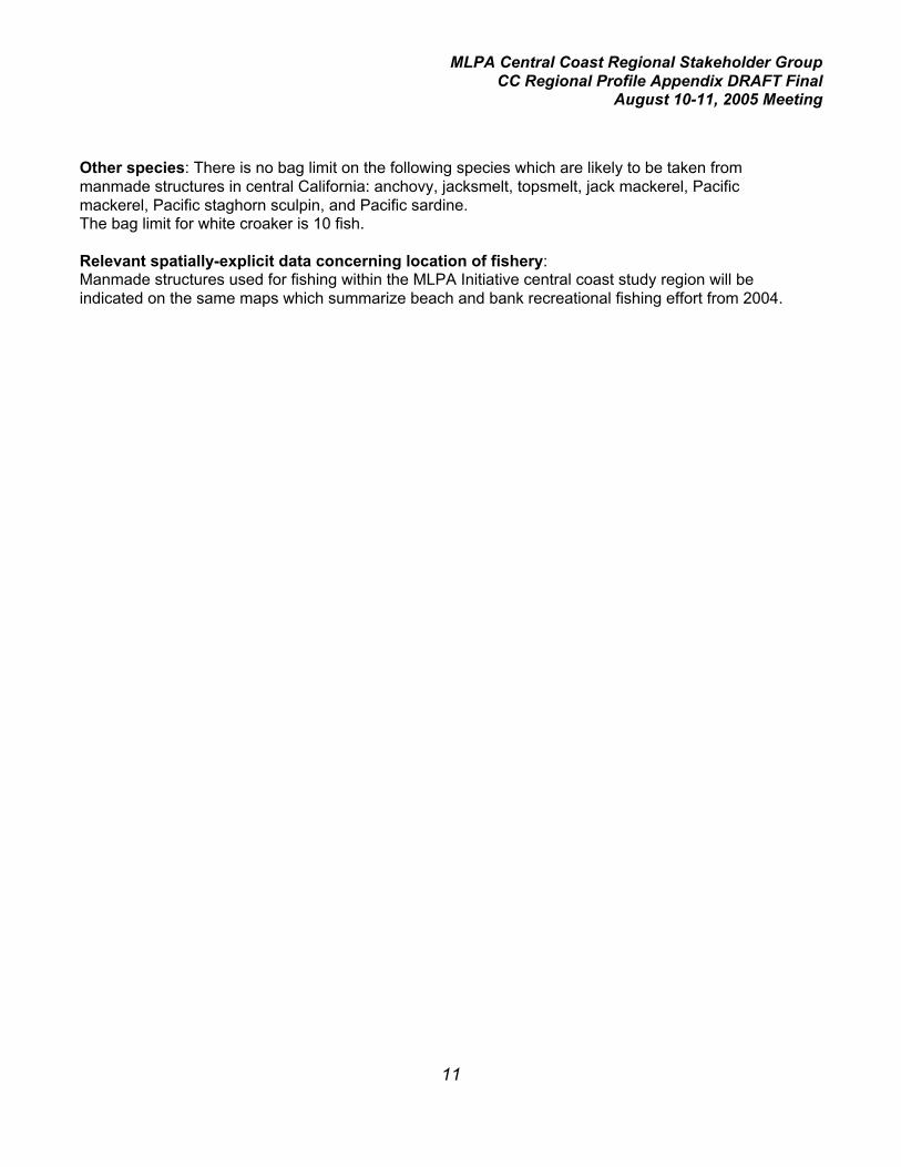
MLPA Central Coast Regional Stakeholder GroupCC Regional Profile Appendix DRAFT Final
August 10-11, 2005 Meeting
11
Other species: There is no bag limit on the following species which are likely to be taken frommanmade structures in central California: anchovy, jacksmelt, topsmelt, jack mackerel, Pacificmackerel, Pacific staghorn sculpin, and Pacific sardine.The bag limit for white croaker is 10 fish.
Relevant spatially-explicit data concerning location of fishery:Manmade structures used for fishing within the MLPA Initiative central coast study region will beindicated on the same maps which summarize beach and bank recreational fishing effort from 2004.

MLPA Central Coast Regional Stakeholder GroupCC Regional Profile Appendix DRAFT Final
August 10-11, 2005 Meeting
12
Profile of Major Recreational Fisheries in the Central Coast Study Region: Fishing viaScuba Diving/Free Diving
Fishing mode: scuba diving and free divingPort area: Monterey and Morro Bay
Species targeted: rockfishes (Sebastes sp.), lingcod (Ophiodon elongatus), California halibut(Paralichthys californicus), cabezon (Scorpaenichthys marmoratus), kelp greenling (Hexagrammosdecagrammus), rubberlip surfperch (Rhacochilus toxotes), striped surfperch (Embiotoca lateralis), blacksurfperch (E. jacksoni), California halibut (Paralichthys californicus)
Estimated number of diver trips in 2004 in study region: (not available at present)
2004 estimated catch of most frequently observed species (number of fish): (not available atpresent)
Comments:
Primary depth range: 0 – 15 fathoms
Primary habitat type(s): kelp beds and nearshore rocky reefs, nearshore sand bottom (for halibut)
Primary area of fishery: State waters__X___Federal waters_____
Synopsis of regulations applicable to central coast study region:Rockfishes, cabezon, kelp greenling, and lingcod: Diving and spearfishing are permitted duringseasonal closures to hook-and-line gear. Except for spearfishing gear, all other types of fishing gear areprohibited to be aboard the vessel or non-motorized watercraft while spearfishing for the purpose ofretaining groundfish and associated species.
Fishing for lingcod is prohibited in January, February, March, and December.
The bag limit for rockfishes, cabezon, and kelp greenling is 10 fish in combination, all of which may bethe same species, except no more than 1 cabezon, 1 kelp greenling, and 1 bocaccio may be takenwithin this overall bag limit.The bag limit for lingcod is 2 fish.
Minimum legal size: rockfish: none, except bocaccio10 inches; cabezon 15 inches; kelp greenling 12inches; lingcod 24 inches.
Surfperch: The bag limit is 5 in any combination of species, except that the daily bag limit for shinersurfperch is 20.
California halibut: The bag limit in waters north of Point Sur is 3 fish. The bag limit in waters south ofPoint Sur is 5 fish.
Minimum legal size: 22 inches
MLPA Central Coast Regional Stakeholder GroupCC Regional Profile Appendix DRAFT Final
August 10-11, 2005 Meeting
13
Relevant spatially-explicit data concerning location of fishery:A small data base from the CRFS program interviews of private and rental boat fishermen (theinterviews included divers using spears) will be available using the microblock maps within the MLPAInitiative central coast study region. Another set of maps will be provided showing locations of CentralCalifornia Council of Divers competitive free-diving meets, which the Department has monitored sincethe late 1950’s. These maps will depict access points for the meets and the approximate area in whichfishing effort occurred from each access point. Additional sources of data concerning consumptivediving will be provided by diver representatives.

MLPA Central Coast Regional Stakeholder GroupCC Regional Profile Appendix DRAFT Final
August 10-11, 2005 Meeting
I
Appendix IV: Descriptions and Preliminary Evaluations of Existing California MarineProtected Areas in the Central Coast (Department of Fish and Game, 2005)
Contents
Monterey County
1. Elkhorn Slough State Marine Reserve3. Hopkins State Marine Reserve4. Pacific Grove State Marine Conservation Area5. Carmel Bay State Marine Conservation Area7. Point Lobos State Marine Reserve9. Julia Pfeiffer Burns State Marine Conservation Area11. Big Creek State Marine Reserve
San Luis Obispo County
13. Atascadero Beach State Marine Conservation Area14. Morro Beach State Marine Conservation Area15. Pismo State Marine Conservation Area16. Pismo-Oceano State Marine Conservation Area
Santa Barbara County
17. Vandenberg State Marine Reserve

MLPA Central Coast Regional Stakeholder GroupCC Regional Profile Appendix DRAFT Final
August 10-11, 2005 Meeting
1
Descriptions and Preliminary Evaluations of Existing California Marine Protected Areasin the Central Coast (Department of Fish and Game, 2005)
MONTEREY COUNTY
Site name: Elkhorn Slough State Marine Reserve
Year established: 1980Approximate Area: 1.7 nm2 Approximate Shoreline length: 2.7 nmApproximate Depth range (feet): 0 to 10
Habitat types: Estuary with soft bottom
Surrounding habitat types: Similar estuarine soft bottom habitat.
Summary of existing regulations: No take is allowed both through State regulations and designationas a Federal National Estuarine Research Reserve.
Primary objectives: This area was originally designated as an ecological reserve. Fish and GameCode Section 1580 (ecological reserves) states that "the policy of the state is to protect threatened orendangered native plants, wildlife, or aquatic organisms or specialized habitat types, both terrestrialand nonmarine aquatic, or large heterogeneous natural gene pools for the future use of mankindthrough the establishment of ecological reserves." Although the language does not specifically refer toecological reserves in marine areas, the Fish and Game Commission has extended this policy to thoseareas. The Elkhorn Slough Ecological Reserve was established to protect sensitive salt marsh, mudflat,and open water habitats, and to provide a quality, undisturbed estuarine site for education, restoration,research and monitoring.
Existing enforcement: The area is easily-observed, well-known, almost surrounded by land, and hasa Department of Fish and Game facility on site.
Baseline and ongoing monitoring and research studies: Monthly volunteer water quality monitoringsince 1988 at 24 sites around the Slough, including the Reserve. Continuous water quality monitoring,using four sites (two on the Reserve), to measure temperature, salinity, turbidity, dissolved oxygen andpH. Hyperspectral images are being used to map the distribution of plant communities of interest(nuisance algae, eelgrass, pickleweed, native grasses, and noxious weeds). Tidal erosion rates atabout 40 intertidal stations along the main channel and in the MPA are monitored annually. Abundance,feeding rates, and reproductive success of herons, egrets, and cormorants in rookeries are assessedby volunteers. Caspian Tern breeding success is being monitored. Distribution, abundance, anddiversity of shorebirds and waterbirds at seven ponds and tidal lagoons in the MPA are monitored todetect long-term changes or short-term anomalies. Native and invasive crabs are monitored along theestuarine gradient, in areas of different land use. Tracking of shark and ray abundances occurs at onesite in the MPA.
Current research includes: 1) Investigation of use of mudflats and other intertidal habitats byshorebirds, and the influence of tidal and seasonal dynamics. 2) Comparison of invertebratecommunities associated with native oyster beds vs. invasive tubeworm beds. 3) Experiments and timeseries analysis to determine whether invasive upland plants are invading the ecotone and high marsh

MLPA Central Coast Regional Stakeholder GroupCC Regional Profile Appendix DRAFT Final
August 10-11, 2005 Meeting
2
Basic Evaluation: With on-site presence of Department staff, and with a history of baseline monitoringand research studies, the site functions well as one of the few fully-protected estuarine areas in thestate.
Published references related to effectiveness of this MPA: 214, 217Unpublished references related to effectiveness of this MPA: 21Published references related to use of this MPA as a research tool: 20, 67, 188, 202

MLPA Central Coast Regional Stakeholder GroupCC Regional Profile Appendix DRAFT Final
August 10-11, 2005 Meeting
3
Descriptions and Preliminary Evaluations of Existing California Marine Protected Areasin the Central Coast (Department of Fish and Game, 2005)
Site name: Hopkins State Marine Reserve
Year established: 1984Approximate Area: 0.15 nm2 Approximate Shoreline length: 0.95 nmApproximate Depth range (feet): 0 to 60
Habitat types: Mostly granite reef; smaller portions of sand, especially on outside edge
Surrounding Habitat types: Similar
Summary of existing regulations: No take is allowed.
Primary objectives: The primary purpose is to allow for research in an area that is free of disturbancedue to exploitation.
Existing enforcement: The area is easily-observed from shore, well-known, marked on the seawardboundary by buoys, and staff from the Hopkins Marine Station is on site every day.
Baseline and ongoing monitoring and research studies: Numerous studies of algae, invertebrates,and fish have taken place. Long-term monitoring of the intertidal zone dates back to the 1930=s. TheDepartment carried out relatively intensive fish counts, and some re-monitoring of those counts hastaken place. A recent study was completed comparing counts and sizes of benthic fishes in andadjacent to the MPA. In addition, the Partnership for Interdisciplinary Studies of Coastal Oceans(PISCO) has had permanent intertidal and subtidal monitoring sites here for several years.
Basic Evaluation: The area contains one of the oldest fully-protected marine research sites in thestate and contains a variety of shallow habitat types within a relatively small area. It is a classicexample of how a small but fully protected MPA can function well by providing a multitude of researchopportunities with populations of marine organisms occurring at natural densities and size frequencies.While it is relatively small, studies have documented significantly greater biomass and size frequenciesof nearshore fishes compared with adjacent fished areas. This site is overlapped by a State WaterQuality Protection Area designation.
Published references related to effectiveness of this MPA: 31, 112, 117, 137, 141, 171, 174, 22Unpublished references related to effectiveness of this MPA: 136Published references related to use of this MPA as a research tool: 16, 40, 53, 75, 113, 170, 177,183, 191, 192, 203, 209Unpublished references related to use of this MPA as a research tool: 4, 52, 76The Hopkins Marine Station web site presently lists more than 150 student papers dating back to 1964,most of which involved at least some field work or collection or organisms with HMLR. The web siteaddress is: http://www.marine.stanford.edu/HMSweb/marine-indexes.html

MLPA Central Coast Regional Stakeholder GroupCC Regional Profile Appendix DRAFT Final
August 10-11, 2005 Meeting
4
Descriptions and Preliminary Evaluations of Existing California Marine Protected Areasin the Central Coast (Department of Fish and Game, 2005)
Site name: Pacific Grove State Marine Conservation Area
Year established: 1984Approximate Area: 1.2 nm2 Approximate Shoreline length: 2.5 nmApproximate Depth range (feet): 0 to 60
Habitat types: Mostly granite reef; smaller portions of sand, especially on outside edge. Rock reefs indeeper water have been surveyed by submersibles.
Surrounding habitat types: Similar, except higher proportion of sand bottom offshore.
Summary of existing regulations:Only the following species may be taken recreationally: finfish, and invertebrates other than mollusks orcrustaceans.
Only the following species may be taken commercially by ring net, lampara net, or bait net: sardines,mackerel, anchovies, squid, and herring.
Primary objectives: Established by legislative action, the primary objective is to provide protectionfrom exploitation for certain fishes and invertebrates.
Existing enforcement: The area is easily-observed from shore by law enforcement personnel as wellas private citizens, is well-known, and benefits from an increased community awareness of the need toprotect marine resources. During daylight hours thousands of people pass by or visit the area on a dailybasis.
Baseline and ongoing monitoring and research studies: Many researchers from Department andseveral academic institutions have conducted life-history studies, recruitment studies, and taggingstudies in this region. Tenera Environmental completed a study in 2003 which investigated the effectsof visitor use on the intertidal area and established baseline levels of the more common intertidalspecies. Submersible studies of deeper-water fishes have also been carried out offshore of this site.
Basic Evaluation: The area presently offers some resource protection since regulations prohibitcommercial finfishing (except for pelagic species) and allow the harvest of only certain invertebrates.Among the invertebrate species permitted for take, the presence of the sea otter precludes mostharvest by man for some of these (e.g. urchin). However, the area does function well as an MPA byproviding recreational opportunities, allowing a low but sustainable level of kelp and recreational finfishharvest, and providing a safe and local site for scientific collecting for research and public education.This area contains extensive intertidal and subtidal reef habitat and provides easy access to intertidalareas from shore. It also provides a source of kelp for local aquaculture businesses. Part of this site isoverlapped by a State Water Quality Protection Area designation.
Unpublished references related to effectiveness of this MPA: 99, 100, 101, 118, 142, 195Published references related to use of this MPA as a research tool: 130Unpublished references related to use of this MPA as a research tool: 196

MLPA Central Coast Regional Stakeholder GroupCC Regional Profile Appendix DRAFT Final
August 10-11, 2005 Meeting
5
Descriptions and Preliminary Evaluations of Existing California Marine Protected Areasin the Central Coast (Department of Fish and Game, 2005)
Site name: Carmel Bay State Marine Conservation Area
Year established: 1976Approximate Area: 1.9 nm2 Approximate Shoreline length: 5.8 nmApproximate Depth range (feet): 0 to 465
Habitat types: Granite reef along rocky shores; extensive areas of sand offshore; some granitepinnacles; head of Carmel submarine canyon
Surrounding habitat types: Similar except for the submarine canyon, which has greater depths thanin the MPA.
Summary of existing regulations: Take of all living marine resources is prohibited except therecreational take of finfish by hook-and-line or spear and the commercial take of kelp under specificconditions.
Primary objectives: This area was originally designated as an ecological reserve. Fish and GameCode Section 1580 (ecological reserves) states that "the policy of the state is to protect threatened orendangered native plants, wildlife, or aquatic organisms or specialized habitat types, both terrestrialand nonmarine aquatic, or large heterogeneous natural gene pools for the future use of mankindthrough the establishment of ecological reserves." Although the language does not specifically refer toecological reserves in marine areas, the Fish and Game Commission has extended this policy to thoseareas.
Existing enforcement: The area is adjacent to population centers, and is therefore easily observedfrom shore. Pleasure boats, dive boats, and party boats frequent the area. Department providesenforcement presence on the water as well as from land.
Baseline and ongoing monitoring and research studies: The area near Pescadero Point, StillwaterCove, and Arrowhead Point is the focus of a number of marine ecological studies, mostly through MossLanding Marine Labs. San Francisco State University has conducted life-history and recruitmentstudies of fish in this area. A high school class carries out an ongoing monitoring program. There havealso been submersible studies in the surrounding area. In addition, the Partnership for InterdisciplinaryStudies of Coastal Oceans (PISCO) has had permanent intertidal and subtidal monitoring sites here forseveral years.
Basic Evaluation: This area contains reef and sand habitat, a kelp bed, and includes the head of asubmarine canyon. It provides opportunities for recreational angling and diving as well as limitedcommercial kelp harvest but is adjacent to the fully-protected area at Point Lobos. The existing degreeof protection is probably consistent with its uses, and the site appears to function well as an MPA withlimited harvest. The Department has documented its long term use as a fishing area for recreationalanglers on Commercial Passenger Fishing Vessels and in skiffs as well as from extractive free divers(CenCal competitive free-diving competitions). This level of use appears to be sustainable in theabsence of commercial fishing for finfish and invertebrates. The presence of the submarine canyonhead provides a source of spot prawn recruitment to the commercial trap fishery in the adjacent area.This site is overlapped by a State Water Quality Protection Area designation.

MLPA Central Coast Regional Stakeholder GroupCC Regional Profile Appendix DRAFT Final
August 10-11, 2005 Meeting
6
Published references related to effectiveness of this MPA: 57, 175Unpublished references related to effectiveness of this MPA: 43, 99, 100, 101, 104, 105, 115, 118,175, 195Published references related to use of this MPA as a research tool: 36, 66, 69, 70, 71, 74, 86, 90,151, 181, 194, 204, 207Unpublished references related to use of this MPA as a research tool: 4, 6, 23, 129, 180

MLPA Central Coast Regional Stakeholder GroupCC Regional Profile Appendix DRAFT Final
August 10-11, 2005 Meeting
7
Descriptions and Preliminary Evaluations of Existing California Marine Protected Areasin the Central Coast (Department of Fish and Game, 2005)
Site name: Point Lobos State Marine Reserve
Year established: 1973Approximate Area: 0.8 nm2 Approximate Shoreline length: 6.7 nmApproximate Depth range (feet): 0 to 195
Habitat types: Mostly granite reef dropping form shore to sand bottom. Reef habitat with manycrevices and pinnacles. Extensive kelp beds
Surrounding habitat types: Carmel submarine canyon is nearby. Extensive hard bottom offshore, asdetermined from submersible studies.
Summary of existing regulations: No take is allowed.
Primary objectives: This area was originally designated as an ecological reserve. Fish and GameCode Section 1580 (ecological reserves) states that "the policy of the state is to protect threatened orendangered native plants, wildlife, or aquatic organisms or specialized habitat types, both terrestrialand nonmarine aquatic, or large heterogeneous natural gene pools for the future use of mankindthrough the establishment of ecological reserves." Although the language does not specifically refer toecological reserves in marine areas, the Fish and Game Commission has extended this policy to thoseareas.
Existing enforcement: State Park rangers within the adjacent terrestrial reserve monitor access fromshore, and monitor approaches by boats. The presence of visitors every day of the year in the adjacentterrestrial reserve provides an additional deterrent to potential violators of regulations.
Baseline and ongoing monitoring and research studies: UC Santa Cruz students found slightlygreater abundances of benthic fish in the MPA than in adjacent areas. Department has conductedhabitat-based surveys of fish abundance within the MPA. Submersible surveys have been carried outoffshore of the MPA. In addition, the Partnership for Interdisciplinary Studies of Coastal Oceans(PISCO) has had permanent intertidal and subtidal monitoring sites here for several years.
Basic Evaluation: This site contains a complex variety of habitats, primarily hard bottom, and containshigh densities of large, adult bottom fishes such as rockfishes and lingcod. Although relatively small,the MPA functions well as a fully protected area because of its high species diversity and variety ofhabitat, and it is effectively enforced. Studies by the Department and others have documented highpopulation densities and large sizes of economically important nearshore fish species, in particularrockfishes, lingcod, cabezon, and greenlings, with population densities and size frequenciessignificantly greater than in adjacent and more distant fished areas. In addition, the site is a primedestination for non-extractive scuba divers, and use is limited by local policy. This site is overlapped bya State Water Quality Protection Area designation.
Published references related to effectiveness of this MPA: 12, 72, 111, 137, 167, 198Unpublished references related to effectiveness of MPAs: 25, 44, 46, 99, 100, 101, 102, 103, 131,136, 152, 154, 190

MLPA Central Coast Regional Stakeholder GroupCC Regional Profile Appendix DRAFT Final
August 10-11, 2005 Meeting
8
Published references related to use of this MPA as a research tool: 58, 59, 78Unpublished references related to use of this MPA as a research tool: 24
MLPA Central Coast Regional Stakeholder GroupCC Regional Profile Appendix DRAFT Final
August 10-11, 2005 Meeting
9
Descriptions and Preliminary Evaluations of Existing California Marine Protected Areasin the Central Coast (Department of Fish and Game, 2005)
Site name: Julia Pfeiffer Burns State Marine Conservation Area
Year established: 1970Approximate Area: 2.1 nm2 Approximate Shoreline length: 4.0 nmApproximate Depth range (feet): 0 to 710 for MPA boundary, which extends 6000 feet offshore, butsite-specific regulations apply to the harvest of invertebrates only within 1000 feet from shore, which isapproximately 60 feet deep.
Habitat types: Hard and soft bottom. Five sub-categories of habitat: 1) Giant kelp beds; 2) pinnaclesand underwater cliffs; 3) Diopatra (worm) tube beds; 4) unstable gravel and boulder fields; 5) surgechannels; Some pinnacles have up to 75 ft of vertical relief in over 50 ft horizontally.
Surrounding habitat types: Similar habitats are found to south. To the north, Partington Canyonextends close to shore. Offshore is a mixture of hard and soft bottom, with some depths exceeding 300fathoms (1,800 ft) within 3 miles of shore.
Summary of existing regulations:Only the following species may be taken recreationally: finfish, chiones, clams, cockles, rock scallops,native oysters, crabs, lobsters, ghost shrimp, sea urchins, mussels and marine worms except that noworms may be taken in any mussel bed unless taken incidentally to the take of mussels.
Only the following species may be taken commercially: finfish, crabs, ghost shrimp, jackknife clams,sea urchins, squid, kelp and worms except that no worms may be taken in any mussel bed, nor mayany person pick up, remove, detach from the substrate any other organisms, or break up, move ordestroy any rocks or other substrate or surfaces to which organisms are attached.
Primary objectives: This site was established to protect unique habitat primarily due to prevalence ofoutstanding wall and pinnacle communities. It contains the most extensive series of pinnacles andunderwater cliffs along the Big Sur Coast.
Existing enforcement: Enforcement is aided by the lack of access to intertidal and subtidal area fromshore (although fishing from shore occurs at Partington Point) due to park requirements to stay ontrails. Department of Park and recreation staff provide on site presence. Department of Fish and Gameprovides on-water presence. Commercial and recreational harvest restrictions pertain to invertebratesonly, and for those which might be taken illegally, access is difficult at best.
Baseline and ongoing monitoring and research studies: Moss Landing Marine Laboratories-extensive diving surveys from 1987 to 1989 with some follow-up in mid 1990's, related to impacts of themassive landslide and subsequent manipulations by Caltrans in 1983-84. Extensive qualitative surveysof plant, invertebrate, and fish communities in five sub-habitat types have been completed. Contacts:John Oliver, MLML, and Jim Barry, Department of Parks and Recreation. Side-scan sonar maps anddata are available from the Department of Fish and Game. Surveys were completed by Rick Kvitek in1994, 1995, 1997, and 1998.

MLPA Central Coast Regional Stakeholder GroupCC Regional Profile Appendix DRAFT Final
August 10-11, 2005 Meeting
10
Basic Evaluation: The area presently offers little in the way of resource protection since only certaininvertebrates are protected from harvest. Among the allowable species, the presence of the sea otterprecludes most harvest by man for some of these (e.g. crab, urchin) or the species is not found here(lobster). However, the area does function well by providing recreational opportunities. The Departmentof Parks and Recreation has a long-term data base here, including information on habitat, fishes,invertebrates, and algae. At present, except for Big Creek State Marine Reserve, there are no othercomplete no-take areas between Pt. Lobos State Marine Reserve, and Vandenberg State MarineReserve. The northern Boundary of Big Creek State Marine Reserve is about 5 miles from southernboundary of Julia Pfeiffer Burns State Marine Conservation Area. This site is overlapped by a StateWater Quality Protection Area designation.
Unpublished references related to effectiveness of this MPA: 18, 100, 101, 104, 178

MLPA Central Coast Regional Stakeholder GroupCC Regional Profile Appendix DRAFT Final
August 10-11, 2005 Meeting
11
Descriptions and Preliminary Evaluations of Existing California Marine Protected Areasin the Central Coast (Department of Fish and Game, 2005)
Site name: Big Creek State Marine Reserve
Year established: 1994Approximate Area: 1.9 nm2 Approximate Shoreline length: 2.7 nmApproximate Depth range (feet): 0 to 300
Habitat types: Soft intertidal: est. 10%; Hard intertidal: est. 90%; Soft subtidal: est. 18%; Hard subtidal:est. 82%; Soft shelf: est. 88%; Hard shelf: 12%; Kelp beds; many wash rocks and pinnacles.
Surrounding habitat types: To the north and south a mixture of hard and soft bottom with scatteredkelp beds . Several heads of submarine canyons adjacent on seaward side.
Summary of existing regulations: No take is allowed. No disturbance of the bottom; no boats, divingor other use (boat transit only); public entry restricted.
Primary objectives: To satisfy requirements of the Marine Resources Protection Act of 1990 the Fishand Game Commission was required to establish four ecological reserves along the mainland coast.The Big Creek State Marine Reserve (originally named the Big Creek Marine Resources Protection ActEcological Reserve) was one of the reserves established pursuant to the Act. The Act specified that thespecific purpose of these reserves was "to provide for scientific research related to the managementand enhancement of marine resources".
Existing enforcement: Full-time reserve manager provides on-site presence. Local users of adjacentareas (skiff fishermen), who are allowed access through the MPA, assist in insuring compliance withregulations. Department provides on-water enforcement presence.
Baseline and ongoing monitoring and research studies: Benthic habitat mapping andcharacterization: baseline information for entire reserve (Yoklavich, VenTresca). Mapping oceancurrents and related hydrographic studies: ongoing research (C. Collins, F. Schwing). Benthic fishsurveys: baseline research; deep (Yoklavich), subtidal (VenTresca, Paddock). Benthic Invertebrates;some baseline; intertidal (Pearse); subtidal (Mira Parks). Local Fishery (social aspects; Pomeroy,Smiley). PISCO long-term subtidal monitoring site (Carr)
Basic Evaluation: This site contains a variety of habitats with hard and soft substrates, including kelpbeds, and is one of the few existing MPAs which extend to 50 fm depth. This site functions well as acompletely protected area while allowing research, particularly the documentation of populationdensities of nearshore and offshore fishes. Studies by the Department, National Marine FisheriesService, and others have quantified density and size frequency of populations of rockfishes, lingcod,cabezon, and other economically important finfishes within and outside the MPA boundaries, and havefound significant numbers of large, reproductively mature fishes within as well as adjacent to this site.Populations of fishes in adjacent areas are of higher density than within fished areas closer to ports,primarily due to the remoteness of the areas and their difficult access from shore. If fishing pressureincreases in the future in adjacent areas, the MPA will continue to serve as a baseline for indices ofnatural populations. The MPA benefits from the presence of an on-site manager and has excellentenforcement.

MLPA Central Coast Regional Stakeholder GroupCC Regional Profile Appendix DRAFT Final
August 10-11, 2005 Meeting
12
Published references related to effectiveness of this MPA: 54, 137, 144, 145, 198, 201, 215, 216Unpublished references related to effectiveness of this MPA: 58, 59, 60, 64, 102, 103, 106, 115,136, 139, 143, 152, 153, 154, 155, 156, 157, 158, 182, 196, 197, 210, 216Published references related to use of this MPA as a research tool: 145, 146
MLPA Central Coast Regional Stakeholder GroupCC Regional Profile Appendix DRAFT Final
August 10-11, 2005 Meeting
13
Descriptions and Preliminary Evaluations of Existing California Marine Protected Areasin the Central Coast (Department of Fish and Game, 2005)
SAN LUIS OBISPO COUNTY
Site name: Atascadero Beach State Marine Conservation Area
Year established: 1985Approximate Area: 3.9 nm2 Approximate Shoreline length: 1.5 nmApproximate Depth range (feet): 0 to 115
Habitat types: 100% soft bottom
Surrounding Habitat types: similar
Summary of existing regulations: Take of clams is prohibited. Take of other living marine resourcesis allowed.
Primary objectives: Protect Pismo clams from over harvest
Existing enforcement: Department provides enforcement from shore. The primary purpose ofenforcement would be to prevent harvest of sub-legal size clams.
Baseline and ongoing monitoring and research studies: Transects sampled in winter by TheDepartment to monitor recruitment of young.
Basic Evaluation: Between 1990 and 1994, sea otters established themselves within the areacontaining the three Pismo clam state marine conservation areas (SMCA) in San Luis Obispo County.Foraging on the larger clams by otters reduced the availability of legal-sized clams (minimum 4.5inches greatest shell diameter) to recreational harvesters. Department clam transects and interviews ofrecreational clam harvesters, conducted annually in the Pismo Beach to Morro Bay area, documentedthis event. For example, in 1990, 32 of 224 clammers interviewed on Pismo Beach harvested 204 legal-sized clams (6.4 per person). In 1994 and subsequent years, department transects yielded virtually noclams over 3 inches in diameter.
For these reasons, the three state marine conservation areas designed to protect and augment thepopulation of legal-sized Pismo clams no longer meet their original objective.
Published references related to effectiveness of this MPA: 140Unpublished references related to effectiveness of this MPA: 138

MLPA Central Coast Regional Stakeholder GroupCC Regional Profile Appendix DRAFT Final
August 10-11, 2005 Meeting
14
Descriptions and Preliminary Evaluations of Existing California Marine Protected Areasin the Central Coast (Department of Fish and Game, 2005)
Site name: Morro Beach State Marine Conservation Area
Year established: 1985Approximate Area: 4.9 nm2 Approximate Shoreline length: 1.9 nmApproximate Depth range (feet): 0 to 115
Habitat types: 100% soft bottom
Surrounding habitat types: similar
Summary of existing regulations: Take of clams is prohibited. Take of other living marine resourcesis allowed.
Primary objectives: Protect Pismo clams from over harvest
Existing enforcement: Department provides enforcement from shore. The primary purpose ofenforcement would be to prevent harvest of sub-legal size clams.
Baseline and ongoing monitoring and research studies: Transects sampled in winter by TheDepartment to monitor recruitment of young.
Basic Evaluation: Between 1990 and 1994, sea otters established themselves within the areacontaining the three Pismo clam state marine conservation areas (SMCA) in San Luis Obispo County.Foraging on the larger clams by otters reduced the availability of legal-sized clams (minimum 4.5inches greatest shell diameter) to recreational harvesters. Department clam transects and interviews ofrecreational clam harvesters, conducted annually in the Pismo Beach to Morro Bay area, documentedthis event. For example, in 1990, 32 of 224 clammers interviewed on Pismo Beach harvested 204 legal-sized clams (6.4 per person). In 1994 and subsequent years, department transects yielded virtually noclams over 3 inches in diameter.
For these reasons, the three state marine conservation areas designed to protect and augment thepopulation of legal-sized Pismo clams no longer meet their original objective.
Published references related to effectiveness of this MPA: 140Unpublished references related to effectiveness of this MPA: 138

MLPA Central Coast Regional Stakeholder GroupCC Regional Profile Appendix DRAFT Final
August 10-11, 2005 Meeting
15
Descriptions and Preliminary Evaluations of Existing California Marine Protected Areasin the Central Coast (Department of Fish and Game, 2005)
Site name: Pismo State Marine Conservation Area
Year established: 1977Approximate Area: 0.05 nm2 Approximate Shoreline length: 0.3 nmApproximate Depth range (feet): 0 to 16
Habitat types: 100% soft bottom
Surrounding habitat types: similar
Summary of existing regulations: Take of all invertebrates and marine aquatic plants is prohibitedexcept the commercial take of algae other than giant kelp and bull kelp. Take of finfish is allowed.
Primary objectives: To establish baseline for sea otter impact to clam population
Existing enforcement: Department provides enforcement from shore. The primary purpose ofenforcement would be to prevent harvest of sub-legal size clams.
Baseline and ongoing monitoring and research studies: Transects sampled by The Department inwinter to monitor recruitment of young.
Basic Evaluation: Between 1990 and 1994, sea otters established themselves within the areacontaining the three Pismo clam state marine conservation areas (SMCA) and the one invertebrateSMCA in San Luis Obispo County. Foraging on the larger clams by otters reduced the availability oflegal-sized clams (minimum 4.5 inches greatest shell diameter) to recreational harvesters. Departmentclam transects and interviews of recreational clam harvesters, conducted annually in the Pismo Beachto Morro Bay area, documented this event. For example, in 1990, 32 of 224 clammers interviewed onPismo Beach harvested 204 legal-sized clams (6.4 per person). In 1994 and subsequent years,department transects yielded virtually no clams over 3 inches in diameter.
While the primary purpose of this invertebrate conservation area was to protect and enhancepopulations of Pismo clams, the general objective was to provide protection from human harvest to allinvertebrates. While this SMCA no longer meets its objective related to Pismo clams, it does provide along-term index of intertidal and shallow subtidal soft-bottom invertebrate populations in the absence offishing. For this reason it would be useful to retain this small MPA to continue this long-term index.
Published references related to effectiveness of this MPA: 140Unpublished references related to effectiveness of this MPA: 138

MLPA Central Coast Regional Stakeholder GroupCC Regional Profile Appendix DRAFT Final
August 10-11, 2005 Meeting
16
Descriptions and Preliminary Evaluations of Existing California Marine Protected Areasin the Central Coast (Department of Fish and Game, 2005)
Site name: Pismo-Oceano State Marine Conservation Area
Year established: 1985Approximate Area: 11.9 nm2 Approximate Shoreline length: 4.6 nmApproximate Depth range (feet): 0 to 115
Habitat types: 100% soft bottom
Surrounding habitat types: similar
Summary of existing regulations: Take of clams is prohibited. Commercial take of giant kelp and bullkelp is prohibited. Take of other living marine resources is allowed.
Primary objectives: Protect Pismo clams from over harvest
Existing enforcement: Department provides enforcement from shore. The primary purpose ofenforcement would be to prevent harvest of sub-legal size clams.
Baseline and ongoing monitoring and research studies: Transects sampled in winter by TheDepartment to monitor recruitment of young.
Basic Evaluation: Between 1990 and 1994, sea otters established themselves within the areacontaining the three Pismo clam state marine conservation areas (SMCA) in San Luis Obispo County.Foraging on the larger clams by otters reduced the availability of legal-sized clams (minimum 4.5inches greatest shell diameter) to recreational harvesters. Department clam transects and interviews ofrecreational clam harvesters, conducted annually in the Pismo Beach to Morro Bay area, documentedthis event. For example, in 1990, 32 of 224 clammers interviewed on Pismo Beach harvested 204 legal-sized clams (6.4 per person). In 1994 and subsequent years, department transects yielded virtually noclams over 3 inches in diameter.
For these reasons, the three state marine conservation areas designed to protect and augment thepopulation of legal-sized Pismo clams no longer meet their original objective.
Published references related to effectiveness of this MPA: 140Unpublished references related to effectiveness of this MPA: 138
MLPA Central Coast Regional Stakeholder GroupCC Regional Profile Appendix DRAFT Final
August 10-11, 2005 Meeting
17
Descriptions and Preliminary Evaluations of Existing California Marine Protected Areasin the Central Coast (Department of Fish and Game, 2005)
SANTA BARBARA COUNTY
Site name: Vandenberg State Marine Reserve
Year established: 1994Approximate Area: 2.0 nm2 Approximate Shoreline length: 4.5 nmApproximate Depth range (feet): 0 to 60
Habitat types: The area contains a mixture of hard and soft bottom. This is a high energy area that islikely heavily scoured.
Surrounding habitat types: Fairly similar to the north, south, and offshore, although a higherpercentage of soft bottom to the north.
Summary of existing regulations: No take is allowed. No disturbance of bottom; no boats, diving orother use (boat transit only); public entry restricted. In offshore area outside boundaries a recent ban ongill nets was enacted legislatively.
Primary objectives: To satisfy requirements of the Marine Resources Protection Act of 1990 the Fishand Game Commission was required to establish four ecological reserves along the mainland coast.The Vandenberg State Marine Reserve (originally named the Vandenberg Marine ResourcesProtection Act Ecological Reserve) was one of the reserves established pursuant to the Act. The Actspecified that the specific purpose of these reserves was “to provide for scientific research related tothe management and enhancement of marine resources”.
Existing enforcement: Access from land is restricted via Vandenberg Air Force Base securityrestrictions. This is a very remote location that is publicly inaccessible from land and sea.
Baseline and ongoing monitoring and research studies:Benthic habitat mapping (Cochrane USGS). Mapping ocean currents and related hydrographic studies:ongoing research (Russ Vetter, NMFS). Eggs and larval fish surveys: research (Vetter, NMFS).Abalone enhancement, growth studies (Friedman, Haaker). Intertidal invertebrate surveys (PISCO-PeteRaimondi, UCSC; Steve Murray). Evaluation of effects of oil spill on intertidal (Pete Raimondi, UCSC;Andy Lisner, MMS). Some baseline data on fish abundance in the adjacent Purisima Point area existsfrom a Department research cruise in 1998.
Basic Evaluation: This site contains primarily shallow soft-bottom substrate but includes some low-relief subtidal reef. Based on Department surveys in the late 1990s, the site and the immediatelyadjacent area appear to function well in protecting high population densities of black abalone. Theadjacent area, while not within an MPA, benefits from military-imposed restricted access. No other sitesalong the southern California mainland contain high densities of black abalone. An existing militaryclosure near the area (Safety Zone 4) is enforced as a no-stopping area by the Air Force.
Unpublished references related to effectiveness of this MPA: 55Published references related to use of this MPA as a research tool: 56, 205