Bylaw 2010/10 New Zealand Transport Agency (Speed Limits ...
59
Bylaw 2010/10 New Zealand Transport Agency (Speed Limits on State Highways) Bylaw Pursuant to section 61(3) of the Government Roading Powers Act 1989 and the Land Transport Rule: Setting of Speed Limits 2003, the New Zealand Transport Agency hereby makes the following bylaw. B y l a w 1. Title and commencement- This bylaw may be cited as the New Zealand Transport Agency (Speed Limits on State Highways) Bylaw 2010/10 and will come into force 28 days after the date of publication of this notice in the New Zealand Gazette. 2. Interpretation-In this bylaw: "holiday speed limit", "permanent speed limit", "rural area", "rural speed limit", "speed limit", "temporary speed limit" and "variable speed limit" have the same meanings as they have in Part 2 of the Speed Limits Rule. "km/h" means kilometres per hour. "School Zones Notice" means the notice dated the 31st day of May 2005, published in the New Zealand Gazette, 2 June 2005, No. 86, page 2051. "Speed Limits Rule" means the Land Transport Rule: Setting of Speed Limits 2003. "State highway" means a State highway as defined in section 2 of the Government Roading Powers Act 1989 and includes a motorway as defined in section 2 of that Act. "traffic sign" has the same meaning as it has in Part 2 of the Land Transport Rule: Traffic Control Devices 2004. "variable speed limit sign" means a traffic sign displaying numerals indicating the speed limit which is capable of displaying different numerals and complies with the Land Transport Rule: Traffic Control Devices 2004. "vehicle" has the same meaning as it has in section 2(1) of the Land Transport Act 1998. 3. Scheduled speed limits- Subject to any temporary speed limits set in accordance with Section 5 of the Speed Limits Rule, the sections of State highway described in the attached Schedules have the speed limits specified in those Schedules, which are part of this bylaw. 4. List of Schedules- Schedule 1 - Speed limits for specified sections of State highway Schedule 2 - Sections of State highway with a variable speed limit (including school zones) Schedule 3 - Sections of State highway with a holiday speed limit 5. Revocation of bylaws-
Transcript of Bylaw 2010/10 New Zealand Transport Agency (Speed Limits ...

Bylaw 2010/10 New Zealand Transport Agency (Speed Limits on State
Highways) Bylaw
Pursuant to section 61(3) of the Government Roading Powers Act 1989 and the Land Transport Rule:
Setting of Speed Limits 2003, the New Zealand Transport Agency hereby makes the following bylaw.
B y l a w
1. Title and commencement-
This bylaw may be cited as the New Zealand Transport Agency (Speed Limits on State
Highways) Bylaw 2010/10 and will come into force 28 days after the date of publication of
this notice in the New Zealand Gazette.
2. Interpretation-In this bylaw:
"holiday speed limit", "permanent speed limit", "rural area", "rural speed limit", "speed limit",
"temporary speed limit" and "variable speed limit" have the same meanings as they have in
Part 2 of the Speed Limits Rule.
"km/h" means kilometres per hour.
"School Zones Notice" means the notice dated the 31st day of May 2005, published in the
New Zealand Gazette, 2 June 2005, No. 86, page 2051.
"Speed Limits Rule" means the Land Transport Rule: Setting of Speed Limits 2003.
"State highway" means a State highway as defined in section 2 of the Government Roading
Powers Act 1989 and includes a motorway as defined in section 2 of that Act.
"traffic sign" has the same meaning as it has in Part 2 of the Land Transport Rule: Traffic
Control Devices 2004.
"variable speed limit sign" means a traffic sign displaying numerals indicating the speed limit
which is capable of displaying different numerals and complies with the Land Transport Rule:
Traffic Control Devices 2004.
"vehicle" has the same meaning as it has in section 2(1) of the Land Transport Act 1998.
3. Scheduled speed limits-
Subject to any temporary speed limits set in accordance with Section 5 of the Speed Limits
Rule, the sections of State highway described in the attached Schedules have the speed
limits specified in those Schedules, which are part of this bylaw.
4. List of Schedules-
Schedule 1 - Speed limits for specified sections of State highway
Schedule 2 - Sections of State highway with a variable speed limit (including school zones)
Schedule 3 - Sections of State highway with a holiday speed limit
5. Revocation of bylaws-

The New Zealand Transport Agency (Maximum Speeds of Vehicles on State Highways) Bylaw
2005/7*, and all bylaws amending that bylaw, are hereby revoked.
6. Other speed limits continue in force-
For the avoidance of doubt:
(a) Notwithstanding clause 5 of this bylaw, all speed limits saved under section 4 of the
Transport Amendment Act 1997 continue in force unless they have been, or are,
superseded by a speed limit fixed on or after 5 April 2004.
(b) Except where a different speed limit is specified under this bylaw, and subject to any
temporary speed limits set in accordance with Section 5 of the Speed Limits Rule, the
speed limit for motorways and State highways in rural areas is the rural speed limit in
accordance with Rule 2.3 of the Speed Limits Rule.
7. Authority to make bylaw-
This bylaw was made by the Group Manager, Highways and Network Operations, under
delegated authority of the New Zealand Transport Agency.
Signed on behalf of New Zealand Transport Agency by:
COLIN CRAMPTON, Group Manager, Highways and Network Operations.

SCHEDULES
Schedule 1- Speed limits for specified sections of State highway
Schedule 1 is attached to this bylaw as a separate table.

SCHEDULE 2
Sections of State highway with a variable speed limit (including school zones)
Section of State highway Speed limit
The southbound section of State Highway 1 at
Wellington from the Helston Road overbridge at
Johnsonville to a point approximately 150
metres south of the southern portal of the
Terrace Tunnel, including all on-ramps and off-
ramps within this section of State highway.
A variable speed limit of 50, 60, 70, 80, 90 or
100 km/h.
A speed limit applies from the point on the State
highway at which a variable speed limit sign
facing the road user is installed to the point in
the direction of travel on the State highway at
which a traffic sign indicating that a different
speed limit applies is installed.
The speed limit that applies is:
(a) that indicated by the numerals displayed on
the variable speed limit sign, or
(b) 100 km/h, if the variable speed limit sign is
blank.
The northbound section of State Highway 1 at
Wellington from a point approximately 320
metres south of the southern portal of the
Terrace Tunnel to a point approximately 90
metres north of the Helston Road overbridge at
Johnsonville, including all on-ramps and off-
ramps within this section of State highway.
As above.
The southbound section of State Highway 2 at
Wellington, from the gantry located
approximately 415 metres north-east of the
southern end of State Highway 2 to the southern
end of State Highway 2 at the Ngauranga
Interchange, including all on-ramps and off-
ramps within this section of State highway.
As above.
Section of State highway Speed limit The
northbound section of State Highway 2 at
Wellington, from the southern end of State
Highway 2 at the Ngauranga Interchange to the
gantry located approximately 400 metres north-
east of the southern end of State Highway 2,
including all on-ramps and off-ramps within this
section of State highway.
As above.
The section of State Highway 74 (Main North
Road) in Christchurch City from a point
approximately 100 metres to the north-east of
the intersection of State Highway 74 with Swift
Any time during any period specified in
condition 2 of the School Zones Notice when a
variable speed limit sign installed on the section
of State highway displays the numerals "40", the

Section of State highway Speed limit
Street to a point approximately 170 metres to
the south-west of the intersection of State
Highway 74 with Lagan Street.
speed limit is 40 km/h.
At all other times the speed limit is 60 km/h.
The section of State Highway 75 (Halswell Road)
in Christchurch City from a point approximately
240 metres to the north-east of the intersection
of State Highway 75 with Larsens Road to a point
approximately 90 metres to the south-west of
the intersection of State Highway 75 with
O'Halloran Drive.
As above.
The section of State Highway 6 (Main South
Road) in Karoro at Greymouth from a point
approximately 20 metres north of the
intersection of State Highway 6 with Rata Street
to a point approximately 30 metres to the north
of the intersection of State Highway 6 with
Stanton Crescent.
Any time during any period specified in
condition 2 of the School Zones Notice when a
variable speed limit sign installed on the section
of State highway displays the numerals "40", the
speed limit is 40 km/h.
At all other times the speed limit is 70 km/h.
The section of State Highway 1 (Craigie Avenue)
in south Timaru from a point approximately 140
metres north of the intersection of State
Highway 1 with Queen Street to a point
approximately 160 metres to the south of that
intersection.
Any time during any period specified in
condition 2 of the School Zones Notice when a
variable speed limit sign installed on the section
of State highway displays the numerals "40", the
speed limit is 40 km/h.
At all other times the speed limit is 50 km/h.
The section of State Highway 23 (Massey Street)
in Hamilton City from a point approximately 40
metres to the west of the intersection of State
Highway 23 with Campbell Street to a point
approximately 50 metres to the west of the
intersection of State Highway 23 with Rifle Range
Road.
As above.
The section of State Highway 26 (Morrinsville
Road) in Hamilton City from a point
approximately 105 metres to the north-east of
the intersection of State Highway 26 with
Cambridge Road to a point approximately 20
metres to the south-west of the intersection of
State Highway 26 with Berkley Avenue.
Any time during any period specified in
condition 2 of the School Zones Notice when a
variable speed limit sign installed on the section
of State highway displays the numerals "40", the
speed limit is 40 km/h.
At all other times the speed limit is 60 km/h.
The section of State Highway 39 (Horotiu Road)
at Te Kowhai from a point approximately 30
metres to the south of the intersection of State
Highway 39 with Te Kowhai Road to a point
approximately 90 metres to the north of the
intersection of State Highway 39 with Bedford
Road.
Any time during any period specified in
condition 2 of the School Zones Notice when a
variable speed limit sign installed on the section
of State highway displays the numerals "40", the
speed limit is 40 km/h.
At all other times the speed limit is 50 km/h.

Section of State highway Speed limit
The section of State Highway 1 (Great South
Road) in Ngaruawahia from a point
approximately 115 metres to the north-west of
the intersection of State Highway 1 with Ellery
Street to a point approximately 20 metres to the
south-east of the intersection of State Highway 1
with Belt Street.
As above.
The section of State Highway 1 (Main North
Road) at Woodend from a point approximately
70 metres to the north of
the intersection of State Highway 1 with
Gladstone Road to a point approximately
55 metres to the south of the intersection of
State Highway 1 with Petries Road.
Any time during any period specified in
condition 2 of the School Zones Notice when a
variable speed limit sign installed on the section
of State highway displays the numerals "40", the
speed limit is 40 km/h.
At all other times the speed limit is 50 km/h.
The section of State Highway 6 (Main South
Road) at Paroa from a point approximately 380
metres north of the intersection of State
Highway 6 with Rutherglen Road to a point
approximately 30 metres north of that
intersection.
Any time during any period specified in
condition 2 of the School Zones Notice when a
variable speed limit sign facing the road user
installed on the section of State highway displays
the numerals "40", the speed limit is 40 km/h.
At all other times the speed limit is 80 km/h.

SCHEDULE 3
Sections of State highway with a holiday speed limit
Section of State highway Speed limit
The section of State Highway 12 in the Hokianga
from the intersection of State Highway 12 with
Kokohuia Road to a point approximately 1970
metres to the north of that intersection.
From 1 December in any year to 30 April in the
following year (inclusive of those dates) - 50
km/h.
At any other time - 70 km/h.
The section of State Highway 6 in Marlborough
from a point approximately 320 metres to the
south of the Pelorus Bridge to a point
approximately 320 metres to the north of that
bridge.
From 20 December in any year to 31 January in
the following year (inclusive of those dates) - 50
km/h.
At any other time - 100 km/h.
The section of State Highway 1 in Taupo from a
point approximately 100 metres to the south of
the intersection of State Highway 1 with Hawai
Street to a point approximately 100 metres to
the south of the northern intersection of State
Highway 1 with Rainbow Drive.
From 20 December in any year to the first
Tuesday following the Easter Sunday in
the following year (inclusive of those dates) -
50 km/h.
At any other time - 70 km/h.
The section of State Highway 60 in Golden Bay
from a point approximately 30 metres to the
south-west of the Paynes Ford Bridge to a point
approximately 60 metres to the north of the
Rameka Creek Bridge.
From 20 December in any year to 31 January in
the following year (inclusive of those dates) - 80
km/h.
At any other time - 100 km/h.
*Published as the Transit New Zealand (Maximum Speeds of Vehicles on State Highways) Bylaw
2005/7 in the Supplement to the New Zealand Gazette, 28 September 2005, No. 164, page 4075.

NZTA Bylaw 2010/10
Schedule 1: Speed Limits for Specified Sections of State Highway
Northland / Auckland State Highways
Line
No.
Region SH
No.
Locality Section of State Highway Speed Limit
(km/h)
New Zealand Gazette Reference
1 1 1N Te Kao From 30m north of Potahi Road to 45m south of Te Ahu Road. 70 1/09/2010, No 112, page 2967
2 1 1N Pukenui From 150m south of Lambs Bridge to 800m south of Lambs Bridge. 50 1/09/2010, No 112, page 2967
3 1 1N Awanui From SH10 to Spains Road. 50 1/09/2010, No 112, page 2967
4 1 1N Awanui From SH10 to 300m south of Gill Road. 50 1/09/2010, No 112, page 2967
5 1 1N Kaitaia From 700m north of Donald Road to 100m north of Donald Road. 70 1/09/2010, No 112, page 2967
6 1 1N Kaitaia From 100m north of Donald Road to 212m south of Hester Street. 50 1/09/2010, No 112, page 2967
7 1 1N Mangamuka
Bridge
From 160m south-east of Mohuiti-Mangamuka Road to 320m north of
Mohuiti-Mangamuka Road.
70 1/09/2010, No 112, page 2967
8 1 1N Okaihau From 150m west of Settlers Way (Horeke Road) to 350m east,
generally, of Settlers Way.
70 1/09/2010, No 112, page 2967
9 1 1N Ohaeawai From 340m north-west of the junction with SH12 to 300m east of the
junction with SH12.
60 1/09/2010, No 112, page 2967
10 1 1N Moerewa From 60m west of Snowden Avenue to Leaity Street. 50 1/09/2010, No 112, page 2967
11 1 1N Moerewa From Leaity Street to 330m east of Sir William Hale Crescent. 70 1/09/2010, No 112, page 2967
12 1 1N Moerewa From 330m east of Sir William Hale Crescent to 120m east of
Taumatamakuku Settlement Road.
80 1/09/2010, No 112, page 2967
13 1 1N Kawakawa From 160m north of Station Road to 70m south of Neumann Street
(SH1N / SH11 intersection).
50 1/09/2010, No 112, page 2967
14 1 1N Springs Flat From 870m north of Great North Road to 100m south of Great North
Road.
60 1/09/2010, No 112, page 2967
15 1 1N Kamo Bypass From 100m south of Great North Road to 40m north of Kamo Road. 80 1/09/2010, No 112, page 2967
16 1 1N Whau Valley From 40m north of the Kamo Road roundabout to 250m south of
Russell Road.
50 1/09/2010, No 112, page 2967

Line
No.
Region SH
No.
Locality Section of State Highway Speed Limit
(km/h)
New Zealand Gazette Reference
17 1 1N Western Hills
Drive
From 250m south of Russell Road to 170m north of Selwyn Avenue. 70 1/09/2010, No 112, page 2967
18 1 1N Western Hills
Drive
From 170m north of Selwyn Avenue to 160m south of Murdoch
Crescent.
50 1/09/2010, No 112, page 2967
19 1 1N Whangarei From 160m south of Murdoch Crescent to 130m south of Toetoe Road. 80 1/09/2010, No 112, page 2967
20 1 1N Brynderwyn Hills From a point 1.300km south of Waipu Gorge Road to a point 160m
south of the southern abutment of the Piroa Stream Bridge.
80 1/09/2010, No 112, page 2967
21 1 1N Kaiwaka From 80m north-west of Kaiwaka / Mangawhai Road intersection to
400m south of Kaiwaka / Mangawhai Road intersection.
50 1/09/2010, No 112, page 2967
22 1 1N Kaiwaka From 400m south of Kaiwaka-Mangawhai Road to 300m south of
Settlement Road.
70 1/09/2010, No 112, page 2967
23 1 10 Kerikeri From 970m south of Kerikeri Road, extending northerly to 1.080km
north of Kerikeri Road.
80 1/09/2010, No 112, page 2967
24 1 10 Waipapa From 50m south of Pataka Lane to 400m north of Waipapa Road. 70 1/09/2010, No 112, page 2967
25 1 10 Kaeo From 60m east of Martin Road to 140m east of Waikare Avenue. 70 1/09/2010, No 112, page 2967
26 1 10 Kaeo From 140m east of Waikare Avenue to 350m west of Waikare Avenue. 50 1/09/2010, No 112, page 2967
27 1 10 Mangonui to
Taipa
From 50m east of Wrathall Road to 200m west of Mamaru Road. 60 1/09/2010, No 112, page 2967
28 1 10 Awanui From 330m east of the SH10 / SH1N intersection to the SH10 / SH1N
intersection.
50 1/09/2010, No 112, page 2967
29 1 11 Kawakawa From SH1N to the Ruapekapeka Road / SH11 intersection. 50 1/09/2010, No 112, page 2967
30 1 11 Kawakawa to
Paihia
From 340m north of the northern abutment of the Taumarere Stream
Bridge to 95m south of Tohitapu Road, Paihia.
80 1/09/2010, No 112, page 2967
31 1 11 Paihia From 95m south of Tohitapu Road to 300m south-west of Te Kemara
Road.
50 1/09/2010, No 112, page 2967
32 1 11 Haruru From 50m east of Yorke Road to 30m west of Haruru Falls Road. 70 1/09/2010, No 112, page 2967
33 1 12 Ohaeawai From the Ohaeawai Junction to 50m west of Remuera Settlement Road. 60 1/09/2010, No 112, page 2967
34 1 12 Kaikohe From 300m north of Reservoir Road to 50m north of Reservoir Road. 70 1/09/2010, No 112, page 2967
35 1 12 Kaikohe From 50m north of Reservoir Road to 520m south-west of Station 50 1/09/2010, No 112, page 2967

Line
No.
Region SH
No.
Locality Section of State Highway Speed Limit
(km/h)
New Zealand Gazette Reference
Road.
36 1 12 Kaikohe From 520m south-west of Station Road to 50m south from
Rangihamama Road.
70 1/09/2010, No 112, page 2967
37 1 12 Opononi From 2.460km north of Kokohuia Road to 1.970km north of Kokohuia
Road.
50 1/09/2010, No 112, page 2967
38 1 12 Opononi Holiday
Speed Limit
From 1.970km north of Kokohuia Road to Kokohuia Road. See
Schedule 3
1/09/2010, No 112, page 2967
39 1 12 Opononi From Kokohuia Road to 320m north of Signal Station Road. 50 1/09/2010, No 112, page 2967
40 1 12 Waimamaku From 70m west of Waimamaku River (Hallahan's Bridge) to 250m east
of Taita Road.
70 1/09/2010, No 112, page 2967
41 1 12 Dargaville From 250m south of Baylys Coast Road to 280m west of the Logan
Street / Murdoch Street intersection.
70 1/09/2010, No 112, page 2967
42 1 12 Dargaville From 280m west of the Logan Street / Murdoch Street intersection to
200m south-east of the Victoria Street / Grey Street intersection.
50 1/09/2010, No 112, page 2967
43 1 12 Ruawai From 550m north-west of the northern abutment of the Muddy Mouth
Creek Bridge to 640m north of the centreline of Porritt Road.
80 1/09/2010, No 112, page 2967
44 1 12 Ruawai From 640m north of the centreline of Porritt Road to 400m east of
Wharf Road.
50 1/09/2010, No 112, page 2967
45 1 12 Ruawai From 400m east of Wharf Road to 40m east of Robertson's Road. 70 1/09/2010, No 112, page 2967
46 1 12 Paparoa From 100m south-west of Pahi Road to 100m south-west of Franklin
Road.
70 1/09/2010, No 112, page 2967
47 1 12 Paparoa From 100m south-west of Franklin Road to 180m south-west of
Paparoa-Oakleigh Road.
50 1/09/2010, No 112, page 2967
48 1 12 Paparoa From 180m south-west to 760m south-east of the Paparoa-Oakleigh
Road.
70 1/09/2010, No 112, page 2967
49 1 12 Maungaturoto From 640m west of Marohemo Road to 100m north-east of Marohemo
Road.
70 1/09/2010, No 112, page 2967
50 1 12 Maungaturoto From 360m south-west of Whaka Road to 200m east of Bickerstaffe
Road.
50 1/09/2010, No 112, page 2967

Line
No.
Region SH
No.
Locality Section of State Highway Speed Limit
(km/h)
New Zealand Gazette Reference
51 1 12 Maungaturoto From 200m east of Bickerstaffe Road to 130m east of Doctors Hill
Road.
70 1/09/2010, No 112, page 2967
52 1 14 Whangarei /
Maunu
From the SH1N / SH14 intersection to Silverstream Road. 50 1/09/2010, No 112, page 2967
53 1 14 Whangarei /
Maunu
From Silverstream Road to 200m west of Cemetery Road. 70 1/09/2010, No 112, page 2967
54 1 14 Maungatapere From 490m north of Mangakahia Road to 520m south of Mangakahia
Road.
70 1/09/2010, No 112, page 2967
55 1 14 Tangiteroria From 560m east of Pukehuia Road to 80m west of Pukehuia Road. 70 1/09/2010, No 112, page 2967
56 1 14 Dargaville From 100m north-east of Awakino River Bridge to 10m north-east of
Finlayson Park Avenue.
70 1/09/2010, No 112, page 2967
57 1 14 Dargaville From 10m north-east of Finlayson Park Avenue to Grey Street. 50 1/09/2010, No 112, page 2967
58 2 1 Te Hana From the northern abutment of the Te Hana Rail Overbridge to 90m
south of Silver Hill Road.
70 1/09/2010, No 112, page 2967
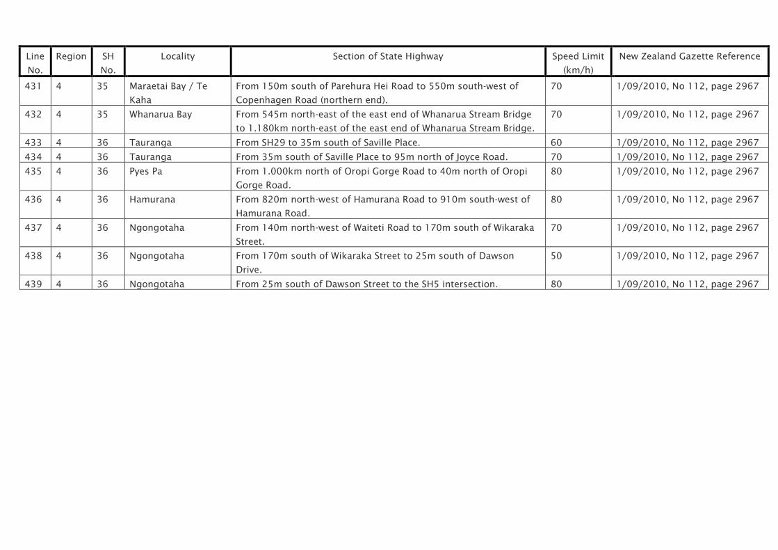
59 2 1 Wellsford From 500m north of School Road to School Road. 70 1/09/2010, No 112, page 2967
60 2 1 Wellsford From School Road to the north-western abutment of the Wellsford
Railway Overbridge.
50 1/09/2010, No 112, page 2967
61 2 1 Wellsford From the north-western abutment of the Wellsford Railway Overbridge
to 650m south of Davies Road.
70 1/09/2010, No 112, page 2967
62 2 1 Dome Valley From 265m south of Wayby Valley Road to 200m south of L. Phillips
Road.
80 1/09/2010, No 112, page 2967
63 2 1 Warkworth From 180m north of Hudson Road to 470m north of Hill Street. 80 1/09/2010, No 112, page 2967
64 2 1 Warkworth From 470m north of Hill Street to 130m south of Woodcocks Road. 60 1/09/2010, No 112, page 2967
65 2 1 Warkworth From 130m south of Woodcocks Road to 60m south of McKinney Road. 80 1/09/2010, No 112, page 2967
66 2 1 Northern Busway
Constellation
Bus Station
From Constellation Drive to 50m south of the centreline of Sunset
Road.
50 1/09/2010, No 112, page 2967
67 2 1 Northern Busway
Constellation to
From 50m south of the centreline of Sunset Road to 240m north of the
centreline of Sunnynook Road.
80 1/09/2010, No 112, page 2967

Line
No.
Region SH
No.
Locality Section of State Highway Speed Limit
(km/h)
New Zealand Gazette Reference
Sunnynook
68 2 1 Northern Busway
Sunnynook Bus
Station
From 240m north of the centreline of Sunnynook Road to 110m south
of the centreline of Sunnynook Road.
50 1/09/2010, No 112, page 2967
69 2 1 Northern Busway
Sunnynook to
Smales Farm
From 110m south of the centreline of Sunnynook Road to 610m north
of the centreline of Northcote Road.
80 1/09/2010, No 112, page 2967
70 2 1 Northern Busway
Smales Farm Bus
Station
From 610m north of the centerline of Northcote Road to 200m north of
the centreline of Northcote Road.
50 1/09/2010, No 112, page 2967
71 2 1 Northern Busway
Smales Farm to
Akoranga
From 200m north of the centreline of Northcote Road to 400m north of
the centreline of Esmonde Road.
80 1/09/2010, No 112, page 2967
72 2 1 Northern Busway
Akoranga Bus
Station
From 400m north of the centreline of Esmonde Road to 75m south of
the centreline of Esmonde Road.
50 1/09/2010, No 112, page 2967
73 2 1 Onewa
Interchange to
Westhaven
SOUTHBOUND - from 45m south of southern abutment of the Onepoto
Stream Bridge to 125m north of the southern abutment of the
Auckland Harbour Bridge.
80 1/09/2010, No 112, page 2967
74 2 1 Westhaven to
Onewa
Interchange
NORTHBOUND - from 75m south of the southern abutment of the
Auckland Harbour Bridge to 300m south of the southern abutment of
the Onepoto Stream Bridge.
80 1/09/2010, No 112, page 2967
75 2 1 Wellington Street
to Gillies Avenue
SOUTHBOUND - from 80m south of the centreline of Wellington Street
Underpass to 430m north of the northern abutment of the Newmarket
Viaduct.
80 1/09/2010, No 112, page 2967
76 2 1 Gillies Avenue to
Wellingon Street
NORTHBOUND - from 240m north of the northern abutment of the
Newmarket Viaduct to 215m south of the centreline of the Wellington
Street Underpass.
80 1/09/2010, No 112, page 2967
77 2 16 Parnell From Quay Street to 840m north-east of Grafton Bridge. 50 1/09/2010, No 112, page 2967

Line
No.
Region SH
No.
Locality Section of State Highway Speed Limit
(km/h)
New Zealand Gazette Reference
78 2 16 Grafton From 840m north-east of Grafton Bridge to Waima / Haslett Footbridge. 80 1/09/2010, No 112, page 2967
79 2 16 Westgate Hobsonville Road from the Motorway Terminus westwards to a point
290m east of Fernhill Drive.
50 1/09/2010, No 112, page 2967
80 2 16 Westgate to
Kumeu
From 290m east of Fernhill Drive to 50m south-east of Old Railway
Road.
80 1/09/2010, No 112, page 2967
81 2 16 Kumeu From 50m south-east of Old Railway Road to 75m north-west of Trigg
Road.
60 1/09/2010, No 112, page 2967
82 2 16 Waimauku From 200m south of Muriwai Road to 650m north of Muriwai Road. 70 1/09/2010, No 112, page 2967
83 2 16 Helensville From the eastern abutment of the Kaipara River Bridge to 120m south
of Kowhai Street.
70 1/09/2010, No 112, page 2967
84 2 16 Helensville From120m south of Kowhai Street to 130m north of West Road. 50 1/09/2010, No 112, page 2967
85 2 16 Kaukapakapa From 120m south of Opoto Place to 160m north of North Crescent
(North).
50 1/09/2010, No 112, page 2967
86 2 16 Wellsford From 1.350km west of Davies Road to Davies Road. 70 1/09/2010, No 112, page 2967
87 2 16 Wellsford From Davies Road to the intersection with SH1. 50 1/09/2010, No 112, page 2967
88 2 17 Waiwera From Fowler Access Road to the northern abutment of the Hatfields
Bridge.
80 1/09/2010, No 112, page 2967
89 2 17 Hatfields Beach From the northern abutment of the Hatfields Bridge to 200m north of
Puriri Avenue.
70 1/09/2010, No 112, page 2967
90 2 17 Orewa From 200m north of Puriri Avenue to 100m south of Moffat Road. 50 1/09/2010, No 112, page 2967
91 2 17 Silverdale From 100m south of Moffat Road to 1.150km south of East Coast
Road.
80 1/09/2010, No 112, page 2967
92 2 17 Dairy Flat From 900m north of Richards Road to 200m north of Richards Road. 80 1/09/2010, No 112, page 2967
93 2 17 Albany From 130m south of Foley Quarry Road to 20m west of Stevenson
Crescent.
80 1/09/2010, No 112, page 2967
94 2 17 Albany From 20m west of Stevenson Crescent to 90m south of Oteha Valley
Road.
50 1/09/2010, No 112, page 2967
95 2 17 Albany From 90m south of Oteha Valley Road to the Greville Road Interchange. 80 1/09/2010, No 112, page 2967
96 2 18 Unsworth Constellation Drive from the start of SH18 to 270m east of Caribbean 50 1/09/2010, No 112, page 2967

Line
No.
Region SH
No.
Locality Section of State Highway Speed Limit
(km/h)
New Zealand Gazette Reference
Drive.
97 2 18 Unsworth From 270m east of Caribbean Drive to Albany Highway Overbridge. 80 1/09/2010, No 112, page 2967
98 2 18 Greenhithe From 195m west of Buckley Avenue to the Motorway Terminus at
Hobsonville Road.
50 1/09/2010, No 112, page 2967
99 2 18
A
Greenhithe From 50m north of the SH18 underpass to Cuthill and then Upper
Harbour Drive to 105m east of the Tauhinu Road roundabout.
70 1/09/2010, No 112, page 2967
100 2 20 Manukau Redoubt Road from the start of SH20 to Great South Road. 50 1/09/2010, No 112, page 2967
101 2 20 Wiri From Great South Road to 50m west of Ash Road. 70 1/09/2010, No 112, page 2967
102 2 20 Wiri From 50m west of Ash Road (along Wiri Station Road) to Roscommon
Road, and from Wiri Station Road (along Roscommon Road and SH20)
to Puhinui Road.
80 1/09/2010, No 112, page 2967
103 2 20 Mt Roskill From the Sandringham Road Extension roundabout to Richardson
Road.
50 1/09/2010, No 112, page 2967
104 2 20
A
Mangere From 300m north of Kirkbride Road to 300m south of Kirkbride Road. 60 1/09/2010, No 112, page 2967
105 2 20
B
Puhinui Puhinui Road from 160m east of SH20 to 360m west of SH20. 50 1/09/2010, No 112, page 2967
106 2 22 Drury Interchange From the south-western abutment of the Hingaia Stream
Bridge to 100m south of the centreline of Burberry Road.
70 1/09/2010, No 112, page 2967
107 2 22 Pukekohe From 430m east of Crown Road to 600m east of Kayes Road. 70 1/09/2010, No 112, page 2967
108 2 22 Pukekohe From 600m east of Kayes Road to 50m west of Adams Drive. 50 1/09/2010, No 112, page 2967

NZTA Bylaw 2010/10
Schedule 1: Speed Limits for Specified Sections of State Highway
Waikato / Bay of Plenty State Highways
Line
No.
Region SH
No.
Locality Section of State Highway Speed Limit
(km/h)
New Zealand Gazette Reference
201 3 1 Huntly From 240m north of East Mine Road to 300m south of Tregoweth
Lane.
70 1/09/2010, No 112, page 2967
202 3 1 Taupiri From 960m north of Gordonton Road to 40m south-west of Kanui
Road.
70 1/09/2010, No 112, page 2967
203 3 1 Ngaruawahia From 500m north-east of River Road to 70m north-east of River
Road.
70 1/09/2010, No 112, page 2967
204 3 1 Ngaruawahia From 70m north-east of River Road to 115m north-west of Ellery
Street.
50 1/09/2010, No 112, page 2967
205 3 1 Ngaruawahia School
Zone
From 115m north-west of Ellery Street to 20m south-east of Belt
Street.
See
Schedule 2
1/09/2010, No 112, page 2967
206 3 1 Ngaruawahia From 20m south-east of Belt Street to 50m north-west of Croall
Crescent.
70 1/09/2010, No 112, page 2967
207 3 1 Horotiu From 80m north of Horotiu Road to 70m south of Horotiu Bridge
Road.
80 1/09/2010, No 112, page 2967
208 3 1 Hamilton From 290m north of the Te Kowhai roundabout to 250m north of
Rifle Range Road.
80 1/09/2010, No 112, page 2967
209 3 1 Hamilton From 250m north of Rifle Range Road to 160m south of Killarney
Road.
60 1/09/2010, No 112, page 2967
210 3 1 Hamilton From 160m south of Killarney Road to 80m north of Kahikatea
Drive.
80 1/09/2010, No 112, page 2967
211 3 1 Hamilton From 80m north of Kahikatea Drive to 40m north-east of Lorne
Street.
60 1/09/2010, No 112, page 2967
212 3 1 Hamilton From 40m north-east of Lorne Street to 180m west of Howell 80 1/09/2010, No 112, page 2967

Line
No.
Region SH
No.
Locality Section of State Highway Speed Limit
(km/h)
New Zealand Gazette Reference
Avenue.
213 3 1 Hamilton From 180m west of Howell Avenue to 70m south of Riverlea Road. 60 1/09/2010, No 112, page 2967
214 3 1 Hamilton From 70m south of Riverlea Road to 100m north of Annebrook
Road.
80 1/09/2010, No 112, page 2967
215 3 1 Cambridge From 500m west of Vogel Street to 20m west of Vogel Street. 70 1/09/2010, No 112, page 2967
216 3 1 Cambridge From 20m west of Vogel Street to 130m west of Shakespeare
Street.
50 1/09/2010, No 112, page 2967
217 3 1 Cambridge From 130m west of Skakespeare Street to 345m north-east of
Shakespeare Street.
80 1/09/2010, No 112, page 2967
218 3 1 Tirau From 285m west of SH27 intersection to 60m east of Kittow Street. 50 1/09/2010, No 112, page 2967
219 3 1 Putaruru From 100m south-west of SH28 (Whites Road) to 150m south of
Market Street.
50 1/09/2010, No 112, page 2967
220 3 1 Putaruru From 150m south of Market Street to 20m south of Railway
Overbridge.
70 1/09/2010, No 112, page 2967
221 3 1 Tokoroa From 55m north of the northern abutment of the Whakauru Stream
Bridge to 90m south of Mossop Road.
60 1/09/2010, No 112, page 2967
222 3 1 Tokoroa From 90m south of Mossop Road to 150m south of Moffat Road. 80 1/09/2010, No 112, page 2967
223 3 1 Huka Falls From 500m north of the southern end of Huka Falls Loop Road to
100m north of Norman Smith Street.
80 1/09/2010, No 112, page 2967
224 3 1 Taupo From 100m north of Norman Smith Street to 60m south of Hawai
Street.
50 1/09/2010, No 112, page 2967
225 3 1 Taupo Holiday Speed
Limit
From 60m south of Hawai Street to 100m south of the Rainbow
Drive northern intersection.
See
Schedule 3
1/09/2010, No 112, page 2967
226 3 1 Waitahanui From 1.325km north of Hurae Road to 25m south of Rotongaio
Road.
70 1/09/2010, No 112, page 2967
227 3 1 Te Rangiita /
Oruatua
From Mac Road to 160m south-west of Oruatua Avenue. 70 1/09/2010, No 112, page 2967
228 3 1 Motuoapa From 200m north of Rangimoana Avenue to 120m south-west of
Parekarangaranga Street.
70 1/09/2010, No 112, page 2967

Line
No.
Region SH
No.
Locality Section of State Highway Speed Limit
(km/h)
New Zealand Gazette Reference
229 3 1 Turangi From 380m north of Gosling Drive to 360m south of Pihanga Road. 80 1/09/2010, No 112, page 2967
230 3 1B Taupiri From SH1 to 340m south-east of Te Putu Street. 70 1/09/2010, No 112, page 2967
231 3 1B Gordonton From 345m north-west of Woodlands Road to 190m south-east of
Piako Road.
70 1/09/2010, No 112, page 2967
232 3 1B Hautapu From 50m north of Bruntwood Road to Hautapu Road. 70 1/09/2010, No 112, page 2967
233 3 1B Hautapu /
Cambridge
From Hautapu Road to 220m north of Taylor Street. 80 1/09/2010, No 112, page 2967
234 3 1B Cambridge From 220m north of Taylor Street to Hamilton Road. 50 1/09/2010, No 112, page 2967
235 3 2 Maramarua From 1.710km north-west of Monument Road to 75m east of
Monument Road.
70 1/09/2010, No 112, page 2967
236 3 2 Ngatea From 480m west of Kohunui Street to Kohunui Street. 70 1/09/2010, No 112, page 2967
237 3 2 Ngatea From Kohunui Street to 180m east of River Road. 50 1/09/2010, No 112, page 2967
238 3 2 Ngatea From 180m east of River Road to 700m east of River Road. 70 1/09/2010, No 112, page 2967
239 3 2 Paeroa From 200m south-east of Opukeko Road to 400m south-east of
Russell Street.
50 1/09/2010, No 112, page 2967
240 3 2 Karangahake From 115m east of Albert Road, Mackaytown, to 127m east of
Seddon Street, Waikino.
80 1/09/2010, No 112, page 2967
241 3 2 Waihi From 40m west of Canon Street to 60m east of Martin Road. 70 1/09/2010, No 112, page 2967
242 3 2 Waihi From 60m east of Martin Road to the southern abutment of the
Coronation Bridge.
50 1/09/2010, No 112, page 2967
243 3 3 On
Ramp
Hamilton From Lorne Street to Ohaupo Road. 60 1/09/2010, No 112, page 2967
244 3 3 Hamilton From the Kahikatea Drive intersection to 25m south-east of Resthill
Crescent.
60 1/09/2010, No 112, page 2967
245 3 3 Hamilton From 25m south-east of Resthill Crescent to 790 south-east of
Resthill Crescent.
70 1/09/2010, No 112, page 2967
246 3 3 Rukuhia From 330m north of Rukuhia Road to 680m south of Rukuhia
Road.
80 1/09/2010, No 112, page 2967
247 3 3 Ohaupo From 30m south of Kaipaki Road to 30m north of Forkert Road. 70 1/09/2010, No 112, page 2967

Line
No.
Region SH
No.
Locality Section of State Highway Speed Limit
(km/h)
New Zealand Gazette Reference
248 3 3 Ohaupo From 30m north of Forkert Road to 255m south-east of Great
Collins Street.
50 1/09/2010, No 112, page 2967
249 3 3 Ohaupo From 255m south-east of Great Collins Street to 60m south of
Ryburn Road.
70 1/09/2010, No 112, page 2967
250 3 3 Te Awamutu From 450m north of Greenhill Drive to 25m north of Benson Street. 70 1/09/2010, No 112, page 2967
251 3 3 Te Awamutu From 25m north of Benson Street to 220m south of Turere Lane. 50 1/09/2010, No 112, page 2967
252 3 3 Te Awamutu From 220m south of Turere Lane to 210m north of Herbert Street,
Kihikihi.
80 1/09/2010, No 112, page 2967
253 3 3 Kihikihi From 210m north-west of Herbert Street to 40m south of Sheehan
Street.
50 1/09/2010, No 112, page 2967
254 3 3 Kihikihi From 40m south of Sheehan Street to 200m south of McAndrew
Street.
70 1/09/2010, No 112, page 2967
255 3 3 Otorohanga From 160m south-east of Bluck Road to 150m north-east of
Thomson Avenue.
70 1/09/2010, No 112, page 2967
256 3 3 Otorohanga From 150m north-east of Thomson Avenue to 180m south-west of
Otewa Road.
50 1/09/2010, No 112, page 2967
257 3 3 Te Kuiti From 50m north of Gadsby Road to 390m south of Gadsby Road. 70 1/09/2010, No 112, page 2967
258 3 3 Te Kuiti From 390m south of Gadsby Road to 700m south-west of Grey
Street.
50 1/09/2010, No 112, page 2967
259 3 3 Piopio From 500m north-east of Kea Street to 300m south-west of Kaka
Street.
50 1/09/2010, No 112, page 2967
260 3 3 Mokau From 90m north of Oha Street to 280m south of Takarei Terrace. 50 1/09/2010, No 112, page 2967
261 3 5 Taupo From the SH1 / SH5 intersection to 65m east of SH1. 50 1/09/2010, No 112, page 2967
262 3 5 Taupo From 65m east of the SH1 intersection to 430m east of the Kiddle
Drive / Arrowsmith Avenue intersection.
80 1/09/2010, No 112, page 2967
263 3 23 Hamilton From SH1 to 40m west of Campbell Street. 50 1/09/2010, No 112, page 2967
264 3 23 Frankton School
Zone
From 40m west of Campbell Street to 50m west of Rifle Range
Road.
See
Schedule 2
1/09/2010, No 112, page 2967
265 3 23 Hamilton From 50m west of Rifle Range Road to 60m west of Newcastle 50 1/09/2010, No 112, page 2967

Line
No.
Region SH
No.
Locality Section of State Highway Speed Limit
(km/h)
New Zealand Gazette Reference
Road.
266 3 23 Whatawhata From 50m east of the Egan Road intersection to 100m west of
Horotiu Road.
80 1/09/2010, No 112, page 2967
267 3 23 Raglan From 70m east of Manukau Road to the end of SH23. 50 1/09/2010, No 112, page 2967
268 3 24 Matamata From SH27 to 140m south-east of Kilbride Road. 50 1/09/2010, No 112, page 2967
269 3 24 Matamata From 140m south-east of Kilbride Road to 80m south-east of
Garland Road.
70 1/09/2010, No 112, page 2967
270 3 25 Waitakaruru From 70m west of Front Miranda Road to 260m east of Duffin
Road.
70 1/09/2010, No 112, page 2967
271 3 25 Kopu From the eastern abutment of the Kopu Bridge to the SH25 / SH26
intersection.
50 1/09/2010, No 112, page 2967
272 3 25 Kopu From the SH25 / SH26 intersection to 380m north of the SH26
intersection.
70 1/09/2010, No 112, page 2967
273 3 25 Totara From Te Arapipi Road to 150m south of Deeble Road. 70 1/09/2010, No 112, page 2967
274 3 25 Thames From 70m south of Rhodes Park entrance to 65m north of Burke
Street.
50 1/09/2010, No 112, page 2967
275 3 25 Thames From 65m north of Burke Street to 40m north of Ash Street. 70 1/09/2010, No 112, page 2967
276 3 25 Thames From 40m north of Ash Street to 160m north of Tararu Creek Road. 50 1/09/2010, No 112, page 2967
277 3 25 Whakatete Bay From 2.330km north of Tararu Creek Road to 3.090km north of
Tararu Creek Road.
70 1/09/2010, No 112, page 2967
278 3 25 Thornton Bay /
Ngarimu Bay
From Lockhart Place to 480m north of Adams Road. 50 1/09/2010, No 112, page 2967
279 3 25 Te Puru From 250m south of Sarjants Road to 830m north of Te Puru Creek
Road.
50 1/09/2010, No 112, page 2967
280 3 25 Waiomu From 480m south of Waiomu Creek Road to 640m north of Waiomu
Creek Road.
50 1/09/2010, No 112, page 2967
281 3 25 Tapu From 720m south of Tapu-Coroglen Road to 45m north of Tapu-
Coroglen Road.
50 1/09/2010, No 112, page 2967
282 3 25 Tapu / Te Mata From 45m north of Tapu-Coroglen Road to 220m north of Te Mata 70 1/09/2010, No 112, page 2967

Line
No.
Region SH
No.
Locality Section of State Highway Speed Limit
(km/h)
New Zealand Gazette Reference
Creek Road.
283 3 25 Coromandel From 250m south of McQuoid Road to 160m south of Strongman
Road.
70 1/09/2010, No 112, page 2967
284 3 25 Coromandel From 160m south of Strongman Road to 200m east of Tiki Road. 50 1/09/2010, No 112, page 2967
285 3 25 Coromandel From 200m east of Tiki Road to 1.140km east of Tiki Road. 70 1/09/2010, No 112, page 2967
286 3 25 Kuaotunu From 1.240km west of the western abutment of the Kuaotunu River
Bridge to the western abutment of the Kuaotunu River Bridge.
70 1/09/2010, No 112, page 2967
287 3 25 Wharekaho /
Simpsons Beach
From 995m north of Leah Road to Leah Road. 50 1/09/2010, No 112, page 2967
288 3 25 Whitianga From 25m north-east of Harbour Lights Terrace to 150m west of
Buffalo Beach Road.
50 1/09/2010, No 112, page 2967
289 3 25 Whitianga From 150m west of Buffalo Beach Road to 175m west of Moewai
Road.
70 1/09/2010, No 112, page 2967
290 3 25 Tairua From 50m north of Ocean Beach Road to 750m north of Cory
Wright Drive.
70 1/09/2010, No 112, page 2967
291 3 25 Tairua From 750m north of Cory Wright Drive to 65m south of Rewa Rewa
Valley Road.
50 1/09/2010, No 112, page 2967
292 3 25 Whangamata From 40m north of Durrant Drive to 35m south of Harry Watt Drive. 70 1/09/2010, No 112, page 2967
293 3 25 Whangamata From 60m north-west of Whangamata Port Road to 100m south of
Archilles Avenue.
50 1/09/2010, No 112, page 2967
294 3 25 Waihi From 80m north-east of Gladestone Road to 50m north of Richmal
Street.
70 1/09/2010, No 112, page 2967
295 3 25 Waihi From 50m north of Richmal Street to SH2 (Rosemont Road). 50 1/09/2010, No 112, page 2967
296 3 26 Hamilton From SH1 to 105m north-east of Cambridge Road. 60 1/09/2010, No 112, page 2967
297 3 26 Berkley School Zone From 105m north-east of Cambridge Road to 20m south-west of
Berkley Avenue.
See
Schedule 2
1/09/2010, No 112, page 2967
298 3 26 Hamilton From 20m south-west of Berkley Avenue to 300m north-east of
Berkley Avenue.
60 1/09/2010, No 112, page 2967
299 3 26 Hamilton From 300m north-east of Berkley Avenue to 1.300km north-east of 80 1/09/2010, No 112, page 2967

Line
No.
Region SH
No.
Locality Section of State Highway Speed Limit
(km/h)
New Zealand Gazette Reference
Ruakura Station Road.
300 3 26 Morrinsville From 900m south-west of Avenue Road to 130m south-west of
Avenue Road.
70 1/09/2010, No 112, page 2967
301 3 26 Morrinsville From 130m south-west of Avenue Road to 35m north-east of Seales
Road.
50 1/09/2010, No 112, page 2967
302 3 26 Morrinsville From 35m north-east of Seales Road to north-east end of Piako
River Bridge.
70 1/09/2010, No 112, page 2967
303 3 26 Tatuanui From 600m south-west of SH27 to 200m north-east of SH27. 70 1/09/2010, No 112, page 2967
304 3 26 Waitoa From 25m north-east of No 1 Road to 200m north-east of Ngarua
Road.
70 1/09/2010, No 112, page 2967
305 3 26 Waihou From 50m south-west of McCarthy Street to 60m north-east of
Campbell Street.
50 1/09/2010, No 112, page 2967
306 3 26 Te Aroha From 120m south-west of Churchill Avenue to 50m north of Tower
View Terrace.
50 1/09/2010, No 112, page 2967
307 3 26 Paeroa From 100m south-west of Ryall Road to 490m south-west of
Rotokohu Road.
80 1/09/2010, No 112, page 2967
308 3 26 Paeroa From 490m south-west of Rotokohu Road to 20m north of Alpha
Street.
50 1/09/2010, No 112, page 2967
309 3 26 Paeroa From 20m north of Alpha Street to 890m north of Alpha Street. 80 1/09/2010, No 112, page 2967
310 3 26 Hikutaia From 840m south of Ferry Road to 280m north of Ferry Road. 70 1/09/2010, No 112, page 2967
311 3 26 Puriri From 240m south of Pururi Valley Road to 400m north of Pururi
Valley Road.
70 1/09/2010, No 112, page 2967
312 3 26 Matatoki From 300m south-east of Matatoki Road to 420m north-west of
Matatoki Road.
70 1/09/2010, No 112, page 2967
313 3 26 Kopu From 450m south-east of the SH25A intersection to the
intersection with the SH25 end of SH26.
70 1/09/2010, No 112, page 2967
314 3 27 Waharoa From 100m north of Hawes Street to 290m south of McGowan
Street.
50 1/09/2010, No 112, page 2967
315 3 27 Matamata From 335m north of Gladstone Road to Ratcliffe Street. 70 1/09/2010, No 112, page 2967

Line
No.
Region SH
No.
Locality Section of State Highway Speed Limit
(km/h)
New Zealand Gazette Reference
316 3 27 Matamata From Ratcliffe Street to Jellicoe Road. 50 1/09/2010, No 112, page 2967
317 3 27 Matamata From Jellicoe Road to 115m south of Burwood Road. 70 1/09/2010, No 112, page 2967
318 3 27 Tirau From 20m north of Frances Street to the intersection with SH1. 50 1/09/2010, No 112, page 2967
319 3 29 Te Poi From 35m east of Stopford Road to 160m west of Te Poi Road. 70 1/09/2010, No 112, page 2967
320 3 29 Hinuera From 700m south-east of Hinuera Road to 300m north-west of
Hinuera Road.
70 1/09/2010, No 112, page 2967
321 3 30 Te Kuiti From SH3 to 240m south-east of Cotter Street. 50 1/09/2010, No 112, page 2967
322 3 30 Benneydale From 35m east of Ohirea Road to 920m east of Maniaiti Road. 50 1/09/2010, No 112, page 2967
323 3 30 Whakamaru From 180m west of the SH30 / SH32 western intersection to 320m
east of the SH30 / SH32 western intersection.
70 1/09/2010, No 112, page 2967
324 3 31/
39
Otorohanga From Maniapoto Road (SH3) to 130m north west of Rangipare
Street.
50 1/09/2010, No 112, page 2967
325 3 32 Tokoroa From SH1 to 420m west of Elizabeth Drive. 50 1/09/2010, No 112, page 2967
326 3 32 Tokoroa From 420m west of Elizabeth Drive to 485m west of Balmoral
Street.
70 1/09/2010, No 112, page 2967
327 3 32 Whakamaru From 320m east of the SH30 / SH32 western intersection to 460m
south of the SH30 / SH32 western intersection.
70 1/09/2010, No 112, page 2967
328 3 37 Waitomo Caves From 160m east of Waitomo Valley Road to the end of SH37. 50 1/09/2010, No 112, page 2967
329 3 39 Ngaruawahia From SH1 to 230m south of Havelock Road. 50 1/09/2010, No 112, page 2967
330 3 39 Whatawhata From 1100m north of Whatawahata Road to Whatawhata Road
(SH23).
70 1/09/2010, No 112, page 2967
331 3 39 Te Kowhai From 220m north of Te Kowhai Road to 30m south of Te Kowhai
Road.
50 1/09/2010, No 112, page 2967
332 3 39 Te Kowhai School
Zone
From 30m south of Te Kowhai Road to 90m north of Bedford Road. See
Schedule 2
1/09/2010, No 112, page 2967
333 3 39 Te Kowhai From 90m north of Bedford Road to 660m south of Bedford Road. 50 1/09/2010, No 112, page 2967
334 3 39 Whatawhata From Whatawhata Road to 50m south of Whatawhata Road. 80 1/09/2010, No 112, page 2967
335 3 39 Ngahinapouri From 680m north of Reid Road to 100m south of Reid Road. 70 1/09/2010, No 112, page 2967
336 3 39 Pirongia From 50m north of Kane Street to Bellot Street. 50 1/09/2010, No 112, page 2967

Line
No.
Region SH
No.
Locality Section of State Highway Speed Limit
(km/h)
New Zealand Gazette Reference
337 3 39 Pirongia From Bellot Street to 1.580km south of Bellot Street. 70 1/09/2010, No 112, page 2967
338 3 41 Tokaanu From 360m north of Kopu Street to 350m south of Kopu Street. 80 1/09/2010, No 112, page 2967
339 4 2 Katikati From 180m north of Hyde Street to 100m south of Marshall Road. 50 1/09/2010, No 112, page 2967
340 4 2 Whakamarama From 200m north of Plummers Road to 180m east of Loop Road. 90 1/09/2010, No 112, page 2967
341 4 2 Te Puna From 180m east of Loop Road to 360m east of Te Puna Road. 80 1/09/2010, No 112, page 2967
342 4 2 Te Puna From 360m east of Te Puna Road to 345m west of Carmichael
Road.
90 1/09/2010, No 112, page 2967
343 4 2 Bethlehem From 345m west of Carmichael Road to 370m east of Bethlehem
Road.
50 1/09/2010, No 112, page 2967
344 4 2 Tauranga From 370m east of Bethlehem Road to 200m south of the
Tauranga Bridge Marina entrance.
80 1/09/2010, No 112, page 2967
345 4 2 Waihi Road
southbound off-ramp
From SH2 to 140m north of Waihi Road. 80 1/09/2010, No 112, page 2967
346 4 2 Waihi Road -
southbound off ramp
From 140m north of Waihi Road to the Waihi Road intersection. 50 1/09/2010, No 112, page 2967
347 4 2 Waihi Road -
northbound off ramp
From SH2 to 145m south of Waihi Road. 80 1/09/2010, No 112, page 2967
348 4 2 Waihi Road -
northbound off ramp
From 145m south of Waihi Road to the Waihi Road intersection. 50 1/09/2010, No 112, page 2967
349 4 2 Waihi Road
northbound on ramp
From the Waihi Road intersection to 120m north of Waihi Road. 50 1/09/2010, No 112, page 2967
350 4 2 Waihi Road -
northbound on ramp
From 120m north of the Waihi Road intersection to SH2. 80 1/09/2010, No 112, page 2967
351 4 2 Cambridge Road -
southbound on ramp
From the Cambridge Road intersection to 80m south of Cambridge
Road.
50 1/09/2010, No 112, page 2967
352 4 2 Cambridge Road -
southbound on ramp
From 80m south of the Cambridge Road intersection to SH2. 80 1/09/2010, No 112, page 2967
353 4 2 Cambridge Road -
northbound off ramp
From SH2 to 125m south of the Cambridge Road intersection. 80 1/09/2010, No 112, page 2967
Line
No.
Region SH
No.
Locality Section of State Highway Speed Limit
(km/h)
New Zealand Gazette Reference
354 4 2 Cambridge Road -
northbound off ramp
From 125m south of the Cambridge Road intersection to
Cambridge Road.
50 1/09/2010, No 112, page 2967
355 4 2 Waihi Road, Judea
Estate - northbound
off ramp
From SH2 to 65m east of Koromiko Street. 80 1/09/2010, No 112, page 2967
356 4 2 Waihi Road, Judea
Estate - northbound
off ramp
From 65m east of Koromiko Street to the Koromiko Street
intersection.
50 1/09/2010, No 112, page 2967
357 4 2 Waihi Road, Judea
Estate - northbound
on ramp
From the Waihi Road intersection to 290m north of Waihi Road. 50 1/09/2010, No 112, page 2967
358 4 2 Waihi Road, Judea
Estate - northbound
on ramp
From 290m north of the Waihi Road intersection to SH2. 80 1/09/2010, No 112, page 2967
359 4 2 Waihi Road, Judea
Estate - southbound
off ramp
From SH2 to 160m north of Waihi Road. 80 1/09/2010, No 112, page 2967
360 4 2 Waihi Road, Judea
Estate - southbound
off ramp
From 160m north of Waihi Road to the Waihi Road intersection. 50 1/09/2010, No 112, page 2967
361 4 2 Chapel Street -
eastbound off ramp
From SH2 to 60m west of Chapel Street. 80 1/09/2010, No 112, page 2967
362 4 2 Chapel Street -
eastbound off ramp
From 60m west of Chapel Street to the Chapel Street intersection. 50 1/09/2010, No 112, page 2967
363 4 2 Chapel Street -
eastbound on ramp
From the Chapel Street intersection to 60m east of Chapel Street. 50 1/09/2010, No 112, page 2967
364 4 2 Chapel Street -
eastbound on ramp
From 60m east of Chapel Street to SH2. 80 1/09/2010, No 112, page 2967
365 4 2 Chapel Street - From Chapel Street to 120m west of the Chapel Street intersection. 50 1/09/2010, No 112, page 2967

Line
No.
Region SH
No.
Locality Section of State Highway Speed Limit
(km/h)
New Zealand Gazette Reference
westbound on ramp
366 4 2 Chapel Street -
westbound on ramp
From 120m west of Chapel Street to SH2. 80 1/09/2010, No 112, page 2967
367 4 2 Chapel Street -
westbound off ramp
From SH2 to 150m west of Chapel Street. 80 1/09/2010, No 112, page 2967
368 4 2 Chapel Street -
westbound off ramp
From 150m west of Chapel Street to the Chapel Street intersection. 50 1/09/2010, No 112, page 2967
369 4 2 Mirrielees Road -
eastbound off ramp
From SH2 to 200m west of Mirrieless Road. 80 1/09/2010, No 112, page 2967
370 4 2 Mirrielees Road -
eastbound off ramp
From 200m west of Mirrieless Road to the Mirrieless Road
intersection.
50 1/09/2010, No 112, page 2967
371 4 2 Mirrieless Road -
eastbound off ramp
From the Marsh Street intersection to Port Gates. 50 1/09/2010, No 112, page 2967
372 4 2 Mirrieless Road -
eastbound on ramp
From Mirrieless Road to 45m east of the Mirrieless Road
intersection.
50 1/09/2010, No 112, page 2967
373 4 2 Mirrieless Road -
eastbound on ramp
From 45m east of Mirrieless Road to SH2. 80 1/09/2010, No 112, page 2967
374 4 2 Dive Crescent -
westbound off ramp
From SH2 to 90m east of Dive Crescent. 80 1/09/2010, No 112, page 2967
375 4 2 Dive Crescent -
westbound off ramp
From 90m east of Dive Crescent to the Dive Crescent intersection. 50 1/09/2010, No 112, page 2967
376 4 2 Marsh Street ramp From the Dive Crescent intersection to the Chapel Street
intersection.
50 1/09/2010, No 112, page 2967
377 4 2 Chapel Street ramp From Marsh Street to the Chapel Street westbound off ramp. 50 1/09/2010, No 112, page 2967
378 4 2 Dive Crescent ramp From Mirrieless Road to Marsh Street. 50 1/09/2010, No 112, page 2967
379 4 2 Mount Maunganui From 200m south of the Tauranga Bridge Marina entrance to
1.050km south-east of the SH2 / SH29 intersection.
70 1/09/2010, No 112, page 2967
380 4 2 Hewletts Road - on
and off ramps
From Aerodrome Road to 265m north west of Spur Ave. 70 1/09/2010, No 112, page 2967

Line
No.
Region SH
No.
Locality Section of State Highway Speed Limit
(km/h)
New Zealand Gazette Reference
381 4 2 Te Puke From 500m north of Te Puke Quarry Road to 40m north-west of
Atuaroa Avenue.
70 1/09/2010, No 112, page 2967
382 4 2 Te Puke From 40m north-west of Atuaroa Avenue to 280m north-west of No
1 Road.
50 1/09/2010, No 112, page 2967
383 4 2 Te Puke From 280m north-west of No. 1 Road to 300m south-east of No. 1
Road.
80 1/09/2010, No 112, page 2967
384 4 2 Waitangi From 900m west of the west end of the Kaituna River Bridge to
150m east of the west end of the Kaituna River Bridge.
70 1/09/2010, No 112, page 2967
385 4 2 Matata From 420m north-west of Kaokaoroa Street to 150m east of Pollen
Street.
60 1/09/2010, No 112, page 2967
386 4 2 Edgecumbe From 125m north-west of Puriri Crescent to 100m south-east of
Bank Road.
50 1/09/2010, No 112, page 2967
387 4 2 Awakeri From 100m west of the SH2 / SH30 western intersection to 80m
east of the SH2 / SH30 eastern intersection.
70 1/09/2010, No 112, page 2967
388 4 2 Taneatua From 150m north-west of Howell Road to 45m east of Station Road. 50 1/09/2010, No 112, page 2967
389 4 2 Kutarere From 250m south-west of Kutarere Wharf Road to 95m west of
Papanui Road.
70 1/09/2010, No 112, page 2967
390 4 2 Opotiki From 100m west of Bairds Road to 110m north-west of Woodlands
Road.
80 1/09/2010, No 112, page 2967
391 4 2 Opotiki From 110m north-west of Woodlands Road to 120m south of Duke
Street.
50 1/09/2010, No 112, page 2967
392 4 2 Opotiki From 120m south of Duke Street to 1.510km south of Duke Street. 70 1/09/2010, No 112, page 2967
393 4 2A Tauranga From SH2 (Tamatea Arikinui Drive) to the western abutment of the
Takitimu Drive Overbridge.
80 1/09/2010, No 112, page 2967
394 4 2A Tauranga From the western abutment of the Takitimu Drive Overbridge to the
northern abutment of the Hairini Bridge.
50 1/09/2010, No 112, page 2967
395 4 2A Tauranga From the northern abutment of the Hairini Bridge to 70m west of
Maungatapu Road.
70 1/09/2010, No 112, page 2967
396 4 2A Tauranga / Harini From 70m west of Maungatapu Road to Maungatapu Road. 50 1/09/2010, No 112, page 2967
Line
No.
Region SH
No.
Locality Section of State Highway Speed Limit
(km/h)
New Zealand Gazette Reference
397 4 5 Rororua From 110m north-west of Ngongotaha Road to 500m north of
Barnard Road.
80 1/09/2010, No 112, page 2967
398 4 5 Rotorua From 500m north of Barnard Road to 80m north of Malfroy Street. 60 1/09/2010, No 112, page 2967
399 4 5 Rotorua From 80m north of Malfroy Street to 40m north of the SH5/SH30
(Old Taupo Road/Hemo Road) intersection.
50 1/09/2010, No 112, page 2967
400 4 5 Rotorua From 40m north of the SH5/SH30 (Old Taupo / Hemo Road)
intersection to 310m south of the SH5 / SH30 (Old Taupo / Hemo
Road) intersection.
80 1/09/2010, No 112, page 2967
401 4 5 Parekarangi From 610m north of Reporoa Road to 330m south of Reporoa
Road.
80 1/09/2010, No 112, page 2967
402 4 5 Golden Springs From 140m north of Aard Avenue to 570m south of Aard Avenue. 80 1/09/2010, No 112, page 2967
403 4 29 Mount Maunganui From SH2 to 300m west of Truman Lane. 70 1/09/2010, No 112, page 2967
404 4 29 Tauranga / Hairini From 125m east of Maungatapu Road to 230m south-west of
Welcome Bay Road.
50 1/09/2010, No 112, page 2967
405 4 29 Tauranga From 230m east of Cameron Road to 150m west of Cameron Road. 70 1/09/2010, No 112, page 2967
406 4 29 Tauriko From 130m north-east of Cambridge Road to 880m north of
Gargan Road.
70 1/09/2010, No 112, page 2967
407 4 30 Rotorua From 310m south of the SH5 / SH30 (Old Taupo Road / Hemo
Road) intersection to 720m north-east of the SH5 / SH30 (Old
Taupo Road / Hemo Road) intersection.
80 1/09/2010, No 112, page 2967
408 4 30 Rotorua From 720m north-east of the SH5 / SH30 (Hemo Road / Old Taupo
Road) intersection to 40m east of Fenton Street.
60 1/09/2010, No 112, page 2967
409 4 30 Rotorua From 40m east of Fenton Street to 60m south of Scott Street. 50 1/09/2010, No 112, page 2967
410 4 30 Rotorua From 60m south of Scott Street to 75m south-west of Tarawera
Road.
70 1/09/2010, No 112, page 2967
411 4 30 Rotorua From 75m south-west of Tarawera Road to 90m north of Coulter
Road.
60 1/09/2010, No 112, page 2967
412 4 30 Rotorua From 90m north of Coulter Road to 80m north of Alfred Road. 70 1/09/2010, No 112, page 2967
413 4 30 Rotorua From 80m north of Alfred Road to 140m north of Rotokawa Road. 80 1/09/2010, No 112, page 2967

Line
No.
Region SH
No.
Locality Section of State Highway Speed Limit
(km/h)
New Zealand Gazette Reference
414 4 30 Ruato / Rotoiti Bays From 380m west of Lake Okataina Road to 420m east of Tamatea
Street.
80 1/09/2010, No 112, page 2967
415 4 30 Rotoma From 120m west of Oxford Road to 530m west of Matahi Road. 70 1/09/2010, No 112, page 2967
416 4 30 Te Teko From 175m west of Huia Crescent to 325m east of Te Teko Road. 50 1/09/2010, No 112, page 2967
417 4 30 Te Teko From 325m east of Te Teko Road to 100m north-east of Galatea
Road.
70 1/09/2010, No 112, page 2967
418 4 30 Awakeri From 30m south-west of the SH2 / SH30 western intersection to
410m north-east of the SH2 / SH30 eastern intersection.
70 1/09/2010, No 112, page 2967
419 4 30 Whakatane From 310m west of the Gateway Drive / SH30 intersection to 100m
north of the northern abutment of the Whakatane Bridge.
80 1/09/2010, No 112, page 2967
420 4 30A Rotorua From the SH5 (Old Taupo Road / Pukuatua Street) intersection to
45m east of Ranolf Street.
60 1/09/2010, No 112, page 2967
421 4 30A Rotorua From 45m east of Ranolf Street to 380m east of the Amohau Street
/ Fenton Street intersection.
50 1/09/2010, No 112, page 2967
422 4 30A Rotorua From 380m east of the Amohau Street / Fenton Street intersection
to the intersection with SH30 (Sala Street).
70 1/09/2010, No 112, page 2967
423 4 33 Mourea From 25m north of Rangitaitaia Road to 500m north of Ngareta
Road.
70 1/09/2010, No 112, page 2967
424 4 33 Okere Falls From 1490m south of Trout Pool Road to 390m north of Trout Pool
Road.
70 1/09/2010, No 112, page 2967
425 4 33 Paengaroa From 110m south-west of Partridge Lane to 120m north of Lemon
Road.
70 1/09/2010, No 112, page 2967
426 4 34 Kawerau From 190m west of Valley Road to 255m east of Fletcher Avenue. 70 1/09/2010, No 112, page 2967
427 4 35 Opotiki From Bridge Street to Goring Street. 50 1/09/2010, No 112, page 2967
428 4 35 Opotiki From Goring Street to 560m east of Goring Street. 70 1/09/2010, No 112, page 2967
429 4 35 Tirohanga From 100m west of Tirohanga Road to 1.160km east of Tirohanga
Road.
80 1/09/2010, No 112, page 2967
430 4 35 Torere From 80m south-west of the south-western abutment of the Torere
Tributary Bridge to 915m north-east of Te Waiiti Road.
70 1/09/2010, No 112, page 2967
Line
No.
Region SH
No.
Locality Section of State Highway Speed Limit
(km/h)
New Zealand Gazette Reference
431 4 35 Maraetai Bay / Te
Kaha
From 150m south of Parehura Hei Road to 550m south-west of
Copenhagen Road (northern end).
70 1/09/2010, No 112, page 2967
432 4 35 Whanarua Bay From 545m north-east of the east end of Whanarua Stream Bridge
to 1.180km north-east of the east end of Whanarua Stream Bridge.
70 1/09/2010, No 112, page 2967
433 4 36 Tauranga From SH29 to 35m south of Saville Place. 60 1/09/2010, No 112, page 2967
434 4 36 Tauranga From 35m south of Saville Place to 95m north of Joyce Road. 70 1/09/2010, No 112, page 2967
435 4 36 Pyes Pa From 1.000km north of Oropi Gorge Road to 40m north of Oropi
Gorge Road.
80 1/09/2010, No 112, page 2967
436 4 36 Hamurana From 820m north-west of Hamurana Road to 910m south-west of
Hamurana Road.
80 1/09/2010, No 112, page 2967
437 4 36 Ngongotaha From 140m north-west of Waiteti Road to 170m south of Wikaraka
Street.
70 1/09/2010, No 112, page 2967
438 4 36 Ngongotaha From 170m south of Wikaraka Street to 25m south of Dawson
Drive.
50 1/09/2010, No 112, page 2967
439 4 36 Ngongotaha From 25m south of Dawson Street to the SH5 intersection. 80 1/09/2010, No 112, page 2967

NZTA Bylaw 2010/10
Schedule 1: Speed Limits for Specified Sections of State Highway
Gisborne / Hawke's Bay State Highways
Line
No.
Region SH
No.
Locality Section of State Highway Speed Limit
(km/h)
New Zealand Gazette Reference
501 5 2 Matawai From 100m west of Kerei Street to 200m south-east of Raumati Street. 50 1/09/2010, No 112, page 2967
502 5 2 Ormond From 80m north of Whitmore to 160m south of Hill Road. 70 1/09/2010, No 112, page 2967
503 5 2 Makaraka From 200m north of the Makaraka intersection to 700m south-west of
the Makaraka intersection.
50 1/09/2010, No 112, page 2967
504 5 35 Tikitiki From 260m west of the Rangitukia Road intersection to 520m south of
the Rangitukia Road intersection.
70 1/09/2010, No 112, page 2967
505 5 35 Te Puia From 80m west of Waipiro Road to 20m south-west of Cemetery Road. 70 1/09/2010, No 112, page 2967
506 5 35 Tokomaru
Bay
From 470m west of Beach Road (Wharf Road) to 240m south of Waiotu
Stream Bridge.
50 1/09/2010, No 112, page 2967
507 5 35 Tolaga Bay From 100m north of Banks Street to 50m south of Hauiti Road. 50 1/09/2010, No 112, page 2967
508 5 35 Tolaga Bay From 50m south of Hauiti Road to 550m south of Hauiti Road. 70 1/09/2010, No 112, page 2967
509 5 35 Okitu From 350m north of Sirrah Street to 100m south-west of Wairere Road. 70 1/09/2010, No 112, page 2967
510 5 35 Gisborne From 270m west of Wheatstone Road to 40m north-west of Coldstream
Road.
70 1/09/2010, No 112, page 2967
511 5 35 Gisborne From 40m north-west of Coldstream Road to 30m west of Lytton Road. 50 1/09/2010, No 112, page 2967
512 5 35 Gisborne From 30m west of Lytton Road to 730m west of Lytton Road. 70 1/09/2010, No 112, page 2967
513 6 2 Nuhaka From 550m north of the Mahia Road intersection to 370m south of the
Mahia Road intersection.
70 1/09/2010, No 112, page 2967
514 6 2 Wairoa From 320m east of Freyberg Street to 150m west of Kitchener Street. 50 1/09/2010, No 112, page 2967
515 6 2 Raupunga From 200m south-east of Putere Road to 360m west of Putere Road. 70 1/09/2010, No 112, page 2967
516 6 2 Putorino From 160m north-east of Waikare Road to 320m west of Waikare Road. 70 1/09/2010, No 112, page 2967
517 6 2 Bay View From 280m north of Franklin Road to 630m south of Onehunga Road. 70 1/09/2010, No 112, page 2967
518 6 2 Napier From 45m east of the SH2 / SH2B intersection at Westshore to 200m 50 1/09/2010, No 112, page 2967

Line
No.
Region SH
No.
Locality Section of State Highway Speed Limit
(km/h)
New Zealand Gazette Reference
south of Elison Street.
519 6 2 Clive From 240m north of Farndon Road to 20m south of Mill Road. 50 1/09/2010, No 112, page 2967
520 6 2 Clive From 20m south of Mill Road to 480m south of Mill Road. 70 1/09/2010, No 112, page 2967
521 6 2 Hastings From 100m north-east of St Georges Road to 960m south-west of Elwood
Road.
70 1/09/2010, No 112, page 2967
522 6 2 Waipawa From 250m north of Racecourse Road to 150m north of Abbotsford
Road.
70 1/09/2010, No 112, page 2967
523 6 2 Waipawa From 150m north of Abbotsford Road to 580m south of Ruataniwha
Street.
50 1/09/2010, No 112, page 2967
524 6 2 Waipukurau From 100m north-east of Ford Road to the southern abutment of the
Tukituki River Bridge.
70 1/09/2010, No 112, page 2967
525 6 2 Waipukurau From the southern abutment of the Tukituki River Bridge to 50m west of
Coughlan Road.
50 1/09/2010, No 112, page 2967
526 6 2 Waipukurau From 50m west of Coughlan Road to 160m west of Hatuma Road. 70 1/09/2010, No 112, page 2967
527 6 38 Frasertown From 40m north of Brownlies Road to 200m south of Scamperdown
Bridge.
70 1/09/2010, No 112, page 2967
528 6 38 Wairoa From 50m north of the northern abutment of the Awatere Bridge No 1 to
Bridge Street.
50 1/09/2010, No 112, page 2967
529 6 50 Napier From Eastern Port Gate to 93m north-east of SH2B / Taradale Road
intersection.
50 1/09/2010, No 112, page 2967
530 6 50 Waiohiki From 235m south-east of Waiohiki Road to 235m west of Omaranui Road. 70 1/09/2010, No 112, page 2967
531 6 50 Fernhill From 320m north-east of Taihape Road to 110m south-east of Gordon
Street.
50 1/09/2010, No 112, page 2967
532 6 50A Flaxmere From 50m west of the York / Maraekakoho intersection to 150m south of
the Maraekakoho / York intersection.
70 1/09/2010, No 112, page 2967
533 6 50A Pakipaki From 400m south of Turamoe Road to 30m west of the SH50A / SH2
intersection.
70 1/09/2010, No 112, page 2967
NZTA Bylaw 2010/10

Schedule 1: Speed Limits for Specified Sections of State Highway
Taranaki / Manawatu / Wanganui State Highways
Line
No.
Region SH
No.
Locality Section of State Highway Speed Limit
(km/h)
New Zealand Gazette Reference
601 7 3 Urenui From 65m east of Ngapapa Street to 160m west of Whakapaki Street. 50 1/09/2010, No 112, page 2967
602 7 3 Bellbock /
Northgate
From 200m north of Egmont Road to 200m north of Vickers Road. 80 1/09/2010, No 112, page 2967
603 7 3 Northgate From 200m north of Vickers Road to 140m north of Smart Road. 70 1/09/2010, No 112, page 2967
604 7 3 Northgate From 140m north of Smart Road to 290m south of Waiwhakaiho
Bridge.
50 1/09/2010, No 112, page 2967
605 7 3 Northgate From 290m south Waiwhakaiho Bridge to 30m north of Waiwaka
Terrace.
70 1/09/2010, No 112, page 2967
606 7 3 New Plymouth From 30m north of Waiwaka Terrace to 125m south of Welbourn
Terrace.
50 1/09/2010, No 112, page 2967
607 7 3 Egmont Village From 320m north of Egmont Road to 260m south of Egmont Road. 70 1/09/2010, No 112, page 2967
608 7 3 Inglewood From 245m west of Ngahere Street to 370m south of Brookes Street. 50 1/09/2010, No 112, page 2967
609 7 3 Midhirst From 10m south of Denbigh Road to 10m south of Beaconsfield Road. 70 1/09/2010, No 112, page 2967
610 7 3 Stratford From 75m north of Flint Road to 30m north of Pembroke Road. 70 1/09/2010, No 112, page 2967
611 7 3 Stratford From 30m north of Pembroke Road to 50m west of Hunt Road. 50 1/09/2010, No 112, page 2967
612 7 3 Stratford From 50m west of Hunt Road to 100m south of Warwick Road. 70 1/09/2010, No 112, page 2967
613 7 3 Eltham From 180m north of Clifford Road to 20m south of Kitchener Street. 50 1/09/2010, No 112, page 2967
614 7 3 Eltham From 20m south of Kitchener Street to 600m south of Kitchener
Street.
70 1/09/2010, No 112, page 2967
615 7 3 Normanby From 120m north of Waihi Road to Ohangai Road. 70 1/09/2010, No 112, page 2967
616 7 3 Hawera From 70m north of Fitzgerald Lane to 50m north of Fantham Street. 70 1/09/2010, No 112, page 2967
617 7 3 Hawera From 50m north of Fantham Street to 35m north of Puawai Street. 50 1/09/2010, No 112, page 2967
618 7 3 Kakaramea From 275m north of Kakaramea Road to 450m south of Wood Street. 70 1/09/2010, No 112, page 2967
619 7 3 Patea From 120m south of Livingstone Lane to 20m north of Hadfield Street. 70 1/09/2010, No 112, page 2967
620 7 3 Patea From Hadfield Street to Devon Street. 50 1/09/2010, No 112, page 2967

Line
No.
Region SH
No.
Locality Section of State Highway Speed Limit
(km/h)
New Zealand Gazette Reference
621 7 3 Patea From 120m south of Bedford Street to 60m south of Railway
Settlement Road.
70 1/09/2010, No 112, page 2967
622 7 3 Waverley From 70m west of Swinbourme Street to 140m west of Gloag Street. 70 1/09/2010, No 112, page 2967
623 7 3 Waverley From 140m west of Gloag Street to 150m east of Lupton Street. 50 1/09/2010, No 112, page 2967
624 7 3A Inglewood From 50m north of Humphries Street to the SH3 / SH3A intersection. 50 1/09/2010, No 112, page 2967
625 7 43 Stratford From the Regan Street intersection to 140m east of Swansea Road. 50 1/09/2010, No 112, page 2967
626 7 43 Stratford From 140m east of Swansea Road to 20m east of Esk Road. 70 1/09/2010, No 112, page 2967
627 7 43 Toko From 220m west of Bruce Road to 80m north of Domain Road. 70 1/09/2010, No 112, page 2967
628 7 43 Whangamomona From 170m west of Whangamomona Road to 80m east of Prospect
Road.
70 1/09/2010, No 112, page 2967
629 7 45 New Plymouth From Eliot Street to 380m south of Barrett Road. 50 1/09/2010, No 112, page 2967
630 7 45 Omata From 115m north of Beach Road to 430m south of Sealy Road. 80 1/09/2010, No 112, page 2967
631 7 45 Oakura From 130m north of Hussey Street to 90m south of Pitcairn Street. 50 1/09/2010, No 112, page 2967
632 7 45 Oakura From 90m south of Pitcairn Street to 50m south of Wairau Road. 70 1/09/2010, No 112, page 2967
633 7 45 Okato From 200m north of Carthew Road to 180m east of Hampton Road. 50 1/09/2010, No 112, page 2967
634 7 45 Pungarehu From 240m north of Pungarehu Road to 460m south of Pungarehu
Road.
70 1/09/2010, No 112, page 2967
635 7 45 Rahotu From 400m north of Upper Kahui Road to 400m south of Upper Kahui
Road.
50 1/09/2010, No 112, page 2967
636 7 45 Opunake From 40m north of the northern abutment of the Otahi Stream Bridge
to 130m south of Aytoun Street.
50 1/09/2010, No 112, page 2967
637 7 45 Manaia From 10m north of Kaipi Street to 200m south of Hassard Street. 50 1/09/2010, No 112, page 2967
638 7 45 Hawera From 980m north-west from Hunter Street to 20m north-west of
Hunter Street.
70 1/09/2010, No 112, page 2967
639 7 45 Hawera From 20m north-west of Hunter Street to the SH3 / SH45 intersection. 50 1/09/2010, No 112, page 2967
640 8 1 Waiouru From 80m north of Andrews Drive to 180m south of Hassett Drive. 70 1/09/2010, No 112, page 2967
641 8 1 Taihape From 60m north of Heron Street to 100m north of Toroa Road. 70 1/09/2010, No 112, page 2967
642 8 Taihape From 100m north of Toroa Road to 200m south of Weka Street. 50 1/09/2010, No 112, page 2967
643 8 1 Mangaweka From 200m north of Raumaewa Road to 240m south of Bank Street. 70 1/09/2010, No 112, page 2967

Line
No.
Region SH
No.
Locality Section of State Highway Speed Limit
(km/h)
New Zealand Gazette Reference
644 8 1 Hunterville From 230m north of Bruce Street to 160m south of Feltham Street. 50 1/09/2010, No 112, page 2967
645 8 1 Bulls From 280m north of Watson Street to 115m south of Taumaihi Street. 50 1/09/2010, No 112, page 2967
646 8 1 Bulls From 115m south of Taumaihi Street to the northern abutment of the
Bulls Bridge.
70 1/09/2010, No 112, page 2967
647 8 1 Sanson From 720m west of the SH1 / SH3 intersection to 260m south of the
SH1 / SH3 intersection.
50 1/09/2010, No 112, page 2967
648 8 1 Foxton From 430m north of Victoria Street to 60m north of Jenks Street. 70 1/09/2010, No 112, page 2967
649 8 1 Foxton From 60m north of Jenks Street to 200m south of Purcell Street. 50 1/09/2010, No 112, page 2967
650 8 1 Levin From 260m south of Lindsay Road to 120m north of Kawiu Road. 70 1/09/2010, No 112, page 2967
651 8 1 Levin From 120m north of Kawiu Road to 60m south of Hokio Beach Road. 50 1/09/2010, No 112, page 2967
652 8 1 Levin From 60m south of Hokio Beach Road to 530 south of Hokio Beach
Road.
70 1/09/2010, No 112, page 2967
653 8 2 Dannevirke From 150m north of Ruahine Street to 200m south of Edinburgh
Street.
50 1/09/2010, No 112, page 2967
654 8 2 Dannevirke From 200m south of Edinburgh Street to 300m south of Makirikiri
Road.
70 1/09/2010, No 112, page 2967
655 8 2 Woodville From 90m east of Nelson Street to 20m west of Gladstone Street. 70 1/09/2010, No 112, page 2967
656 8 2 Woodville From 20m west of Gladstone Street to 150m south of Station Road. 50 1/09/2010, No 112, page 2967
657 8 2 Mangatainoka From 120m north of Ruawhata Road to Carisbrook Road. 70 1/09/2010, No 112, page 2967
658 8 2 Pahiatua From 250m north of Cambridge Street to 70m south of King Street. 50 1/09/2010, No 112, page 2967
659 8 2 Pahiatua From 70m south of King Street to 40m north of Bowen Street. 70 1/09/2010, No 112, page 2967
660 8 2 Eketahuna From 660m north of Macara Street to 20m north of Macara Street. 70 1/09/2010, No 112, page 2967
661 8 2 Eketahuna From 20m north of Macara Street to 120m south of Jones Street. 50 1/09/2010, No 112, page 2967
662 8 3 Wanganui From 210m north of Tirimoana Place to 30m south of St Johns
Heights.
70 1/09/2010, No 112, page 2967
663 8 3 Wanganui From 30m south of St Johns Heights to 110m south of Heads Road. 50 1/09/2010, No 112, page 2967
664 8 3 Cobham Bridge From 110m south of Heads Road to 220m south of Wikitoria Road. 80 1/09/2010, No 112, page 2967
665 8 3 Turakina From 130m north of Turakina Beach Road to 420m south of Cameron
Road.
70 1/09/2010, No 112, page 2967

Line
No.
Region SH
No.
Locality Section of State Highway Speed Limit
(km/h)
New Zealand Gazette Reference
666 8 3 Bulls From 340m north of Edward Street to the SH1 / SH3 intersection. 50 1/09/2010, No 112, page 2967
667 8 3 Sanson From the SH1 / SH3 intersection to 430m east of SH1. 50 1/09/2010, No 112, page 2967
668 8 3 Palmerston North From the Mangaone Stream Bridge to 20m south of Sutton Place. 50 1/09/2010, No 112, page 2967
669 8 3 Woodville From 20m west of North Street to the SH2 / SH3 intersection. 50 1/09/2010, No 112, page 2967
670 8 3 Ashhurst From 340m west of York Street to 630m east of Cambridge Street. 80 1/09/2010, No 112, page 2967
671 8 4 Taumarunui From 160m west of Hakiaha Street to 350m east of Paranui Street. 50 1/09/2010, No 112, page 2967
672 8 4 Manunui From 190m north-west of Rata Street to 210m south-east of SH41. 70 1/09/2010, No 112, page 2967
673 8 4 Owhango From 120m north of Onepu Road to 160m south of Omatane Road. 70 1/09/2010, No 112, page 2967
674 8 4 National Park From 140m north of Carroll Street to 200m south of the SH47
intersection.
80 1/09/2010, No 112, page 2967
675 8 4 Raetihi From 20m north of Ranfurly Terrace to 90m north of George Street. 50 1/09/2010, No 112, page 2967
676 8 4 Raetihi From 90m north of George Street to 310m south of George Street. 80 1/09/2010, No 112, page 2967
677 8 4 Upokongaro From 800m north of Makirikiri Valley to 50m south of Makirikiri Valley
Road.
50 1/09/2010, No 112, page 2967
678 8 4 Wanganui From 200m south of Mateongaonga Stream Bridge to 20m north of
Talbot Street.
70 1/09/2010, No 112, page 2967
679 8 4 Wanganui From 20m north of Talbot Street to the SH3 intersection on Wikitoria
Road and 70m south of Cracroft Drive on Putiki Drive.
50 1/09/2010, No 112, page 2967
680 8 41 Manunui From SH4 to 90m east of SH4. 70 1/09/2010, No 112, page 2967
681 8 43 Taumarunui From 150m south of Kururau Road to Hakiaha Street (SH4). 50 1/09/2010, No 112, page 2967
682 8 47 National Park From the SH4 intersection to 50m east of the SH4 intersection. 80 1/09/2010, No 112, page 2967
683 8 48 Whakapapa From 120m north of Onepa Road to 760m south of Omatane Road. 70 1/09/2010, No 112, page 2967
684 8 49 Ohakune From 140m north of Old Station Road to 20m east of the eastern
abutment of the Mangateitei Stream Bridge.
50 1/09/2010, No 112, page 2967
685 8 49 Ohakune From 20m east of the eastern abutment of the Mangateitei Stream
Bridge to 80m east of Tainui Street.
70 1/09/2010, No 112, page 2967
686 8 49 Waiouru From 320m west of Ngauruhoe Street to SH1. 70 1/09/2010, No 112, page 2967
687 8 54 Cheltenham From 400m east of the SH54 / Kimbolton Road intersection to 220m
south of Kimbolton Road.
70 1/09/2010, No 112, page 2967

Line
No.
Region SH
No.
Locality Section of State Highway Speed Limit
(km/h)
New Zealand Gazette Reference
688 8 54 Feilding From 80m north of Norfolk Crescent to 210m north of North Street. 70 1/09/2010, No 112, page 2967
689 8 54 Feilding From 210m north of North Street to 10m south of East Street. 50 1/09/2010, No 112, page 2967
690 8 54 Feilding From 10m south of East Street to 200m south of Turners Road. 70 1/09/2010, No 112, page 2967
691 8 56 Longburn From 650m west of Carey Street to 640m east of Carey Street. 70 1/09/2010, No 112, page 2967
692 8 56 Palmerston North From the Mangaone Stream Bridge to Maxwells Line. 50 1/09/2010, No 112, page 2967
693 8 57 Shannon From 360m south of Graham Street to 20m north of Vance Street. 70 1/09/2010, No 112, page 2967
694 8 57 Shannon From 20m north of Vance Street to 50m north of Grey Street. 50 1/09/2010, No 112, page 2967
695 8 57 Shannon From 50m north of Grey Street to 170m north of Stafford Street. 70 1/09/2010, No 112, page 2967
696 8 57 Tokomaru From 160m south of Tokomaru Road to 40m north of Tawa Street. 70 1/09/2010, No 112, page 2967
697 8 57 Linton From 260m south of Camp Road to 560m north of Camp Road. 80 1/09/2010, No 112, page 2967
698 8 57 Palmerston North From 110m south of the Aokautere Drive intersection north-east along
Aokautere Drive to 165m east of Petersens Road.
70 1/09/2010, No 112, page 2967
699 8 57 Palmerston North From 165m east of Petersens Road to 960m east of Pahiatua Track. 80 1/09/2010, No 112, page 2967

NZTA Bylaw 2010/10
Schedule 1: Speed Limits for Specified Sections of State Highway
Wellington / Nelson / Marlborough State Highways
Line
No.
Region SH
No.
Locality Section of State Highway Speed Limit
(km/h)
New Zealand Gazette Reference
701 9 1 Otaki From 90m north-east of Waitohu Valley Road to 120m south-west of
Waerenga Road.
50 1/09/2010, No 112, page 2967
702 9 1 Otaki From 120m south-west of Waerenga Road to the southern abutment
of the Otaki River Bridge.
70 1/09/2010, No 112, page 2967
703 9 1 Te Horo From 150m north of Te Horo Beach Road to 420m south of School
Road.
80 1/09/2010, No 112, page 2967
704 9 1 Waikanae From 90m north of Hemi Street to 140m south of Martin Street. 70 1/09/2010, No 112, page 2967
705 9 1 Waikanae From 140m south of Martin Street to 85m south of Te Moana Road. 50 1/09/2010, No 112, page 2967
706 9 1 Waikanae From 85m south of Te Moana Road to 470m south of Te Moana Road. 70 1/09/2010, No 112, page 2967
707 9 1 Otaihanga From 330m north of Otaihanga Road to the southern abutment of the
bridge over Nikau Palm Grove.
80 1/09/2010, No 112, page 2967
708 9 1 Paraparaumu North From the southern abutment of the bridge over Nikau Palm Grove to
370m north of Ihakara Street.
50 1/09/2010, No 112, page 2967
709 9 1 Paraparaumu From 370m north of Ihakara Street to 105m south of Ihakara Street. 70 1/09/2010, No 112, page 2967
710 9 1 Paekakariki From 1.260km north of Beach Road to 450m north of Beach Road. 80 1/09/2010, No 112, page 2967
711 9 1 Paekakariki From 450m north of Beach Road to 400m south of Beach Road. 70 1/09/2010, No 112, page 2967
712 9 1 Paekakariki From 400m south of Beach Road to 380m north-east of Toenga Road. 80 1/09/2010, No 112, page 2967
713 9 1 Pukerua Bay From 380m north-east of Toenga Road to 20m north-east of Toenga
Road.
70 1/09/2010, No 112, page 2967
714 9 1 Pukerua Bay From 20m north-east of Toenga Road to 160m south of Gray Street. 50 1/09/2010, No 112, page 2967
715 9 1 Porirua From 120m north of Ulric Street to 120m south of SH58. 50 1/09/2010, No 112, page 2967
716 9 1 Wellington Variable
Speed Limit
SOUTHBOUND - from the Helston Road Overbridge to 150m south of
the southern portal of the Terrace Tunnel.
See
Schedule 2
1/09/2010, No 112, page 2967

Line
No.
Region SH
No.
Locality Section of State Highway Speed Limit
(km/h)
New Zealand Gazette Reference
717 9 1 Wellington Variable
Speed Limit
NORTHBOUND - from 320m south of the southern portal of the
Terrace Tunnel to 90m north of the Helston Road Overbridge.
See
Schedule 2
1/09/2010, No 112, page 2967
718 9 1 Wellington SOUTHBOUND - from 150m south of the southern portal of the
Terrace Tunnel to 120m south of Taurima Street.
50 1/09/2010, No 112, page 2967
719 9 1 Wellington NORTHBOUND - from 120m south of Taurima Street to 320m south
of the southern portal of the Terrace Tunnel.
50 1/09/2010, No 112, page 2967
720 9 1 Wellington From 120m south of Taurima Street to 80m north of Wellington Road. 70 1/09/2010, No 112, page 2967
721 9 1 Wellington From 80m north of Wellington Road to 90m east of Evans Bay Parade. 50 1/09/2010, No 112, page 2967
722 9 1 Wellington From 90m east of Evans Bay Parade to 160m north of Broadway. 70 1/09/2010, No 112, page 2967
723 9 1 Wellington From 160m north of Broadway to Broadway (end of SH1 north). 50 1/09/2010, No 112, page 2967
724 9 2 Masterton From 90m north of Fourth Street to 320m west of South Belt. 50 1/09/2010, No 112, page 2967
725 9 2 Masterton From 320m west of South Belt to the north-eastern abutment of the
Waingawa River Bridge.
70 1/09/2010, No 112, page 2967
726 9 2 Carterton From 250m north-east of Andersons Line to 160m north-east of
Plimsoll Street.
70 1/09/2010, No 112, page 2967
727 9 2 Carterton From 160m north-east of Plimsoll Street to 80m south of Dalefield
Road.
50 1/09/2010, No 112, page 2967
728 9 2 Greytown From 550m north-east of Hupenui Road to 50m north-east of North
Street.
70 1/09/2010, No 112, page 2967
729 9 2 Greytown From 50m north-east of North Street to 90m south-west of Moroa
Plain Road.
50 1/09/2010, No 112, page 2967
730 9 2 Featherston From 110m east of Boundary Road to 350m west of Boundary Road. 70 1/09/2010, No 112, page 2967
731 9 2 Featherston From 350m west of Boundary Road to 70m east of Watt Street. 50 1/09/2010, No 112, page 2967
732 9 2 Featherston From 70m east of Watt Street to 160m west of Renall Street. 70 1/09/2010, No 112, page 2967
733 9 2 Te Marua From 550m east of Twin Lakes Road to 150m east of Norana Road. 80 1/09/2010, No 112, page 2967
734 9 2 Upper Hutt From 150m east of Norana Road to 250m west of Fergusson Drive
North.
70 1/09/2010, No 112, page 2967
735 9 2 Lower Hutt From 150m north-east of Korokoro Road to 50m west of Cornish
Street.
70 1/09/2010, No 112, page 2967
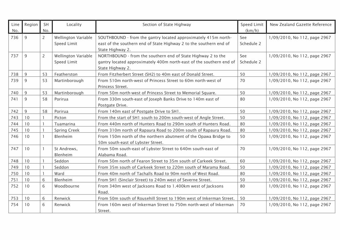
Line
No.
Region SH
No.
Locality Section of State Highway Speed Limit
(km/h)
New Zealand Gazette Reference
736 9 2 Wellington Variable
Speed Limit
SOUTHBOUND - from the gantry located approximately 415m north-
east of the southern end of State Highway 2 to the southern end of
State Highway 2.
See
Schedule 2
1/09/2010, No 112, page 2967
737 9 2 Wellington Variable
Speed Limit
NORTHBOUND - from the southern end of State Highway 2 to the
gantry located approximately 400m north-east of the southern end of
State Highway 2.
See
Schedule 2
1/09/2010, No 112, page 2967
738 9 53 Featherston From Fitzherbert Street (SH2) to 40m east of Donald Street. 50 1/09/2010, No 112, page 2967
739 9 53 Martinborough From 510m north-west of Princess Street to 60m north-west of
Princess Street.
70 1/09/2010, No 112, page 2967
740 9 53 Martinborough From 50m north-west of Princess Street to Memorial Square. 50 1/09/2010, No 112, page 2967
741 9 58 Porirua From 330m south-east of Joseph Banks Drive to 140m east of
Postgate Drive.
80 1/09/2010, No 112, page 2967
742 9 58 Porirua From 140m east of Postgate Drive to SH1. 50 1/09/2010, No 112, page 2967
743 10 1 Picton From the start of SH1 south to 200m south-west of Angle Street. 50 1/09/2010, No 112, page 2967
744 10 1 Tuamarina From 440m north of Hunters Road to 290m south of Hunters Road. 80 1/09/2010, No 112, page 2967
745 10 1 Spring Creek From 310m north of Rapaura Road to 200m south of Rapaura Road. 80 1/09/2010, No 112, page 2967
746 10 1 Blenheim From 150m north of the northern abutment of the Opawa Bridge to
50m south-east of Lybster Street.
50 1/09/2010, No 112, page 2967
747 10 1 St Andrews,
Blenheim
From 50m south-east of Lybster Street to 640m south-east of
Alabama Road.
70 1/09/2010, No 112, page 2967
748 10 1 Seddon From 50m north of Fearon Street to 35m south of Carkeek Street. 60 1/09/2010, No 112, page 2967
749 10 1 Seddon From 35m south of Carkeek Street to 220m south of Marama Road. 50 1/09/2010, No 112, page 2967
750 10 1 Ward From 40m north of Tachalls Road to 90m north of West Road. 80 1/09/2010, No 112, page 2967
751 10 6 Blenheim From SH1 (Sinclair Street) to 240m west of Severne Street. 50 1/09/2010, No 112, page 2967
752 10 6 Woodbourne From 340m west of Jacksons Road to 1.400km west of Jacksons
Road.
80 1/09/2010, No 112, page 2967
753 10 6 Renwick From 50m south of Rousehill Street to 190m west of Inkerman Street. 50 1/09/2010, No 112, page 2967
754 10 6 Renwick From 160m west of Inkerman Street to 750m north-west of Inkerman
Street.
70 1/09/2010, No 112, page 2967

Line
No.
Region SH
No.
Locality Section of State Highway Speed Limit
(km/h)
New Zealand Gazette Reference
755 10 6 Havelock From 50m south of Hodson Street (unformed legal road) to 60m
south of Outram Street.
70 1/09/2010, No 112, page 2967
756 10 6 Havelock From 60m south of Outram Street to 300m north-west of Clive Street. 50 1/09/2010, No 112, page 2967
757 10 6 Pelorus Holiday
Speed Limit
From 320m south of Pelorus Bridge to 320m north-east of Pelorus
Bridge.
See
Schedule 3
1/09/2010, No 112, page 2967
758 10 6 Rai Valley From 340m north of Hills Road to 180m north of Bryants Road. 60 1/09/2010, No 112, page 2967
759 10 6 Hira From 100m south-east of Lud Valley Road to 60m south-east of Cable
Bay Road.
80 1/09/2010, No 112, page 2967
760 10 6 Nelson From 90m north-east of Wildman Ave to 50m north of Whakatu Drive. 50 1/09/2010, No 112, page 2967
761 10 6 Nelson Annesbrook SOUTHBOUND - from 50m north of Whakatu Drive to 60m south-west
of Quarantine Road.
70 1/09/2010, No 112, page 2967
762 10 6 Nelson Annesbrook NORTHBOUND - from 50m north of Whakatu Drive to 160m south-
west of Quarantine Road.
1/09/2010, No 112, page 2967
763 10 6 Richmond From 400m east of Queen Street to 320m south-west of Norman
Andrews Drive.
50 1/09/2010, No 112, page 2967
764 10 6 Hope From 320m south-west of Norman Andrews Drive to 800m south-
west of Ranzau Road East.
70 1/09/2010, No 112, page 2967
765 10 6 Brightwater From 300m south of Clover Road to 380m south of River Terrace
Road.
80 1/09/2010, No 112, page 2967
766 10 6 Wakefield North From 440m north-east of Bird Road to 310m north-east of Franklyn
Close.
70 1/09/2010, No 112, page 2967
767 10 6 Wakefield From 310m north-east of Franklyn Close to 250m south-west of
Pigeon Valley Road.
50 1/09/2010, No 112, page 2967
768 10 6 Wakefield South From 250m south-west of Pigeon Valley Road to 250m west of Eighty
Eight Valley Road.
70 1/09/2010, No 112, page 2967
769 10 6 Murchison From 180m east of Grey Street to 230m west of Fairfax Street. 50 1/09/2010, No 112, page 2967
770 10 60 Richmond From Gladstone Road (SH6) to 400m north-west of Gladstone Road. 50 1/09/2010, No 112, page 2967
771 10 60 Richmond From 400m north-west of Gladstone Road to 200m north-west of
McShane Road / Pugh Road.
80 1/09/2010, No 112, page 2967

Line
No.
Region SH
No.
Locality Section of State Highway Speed Limit
(km/h)
New Zealand Gazette Reference
772 10 60 Ruby Bay From 110m west of Aranui Road to 20m north of Pine Hill Road. 70 1/09/2010, No 112, page 2967
773 10 60 Tasman From 70m south of Kina Beach Road to 50m north of Dicker Road. 70 1/09/2010, No 112, page 2967
774 10 60 Motueka From 230m south of Wharf Road to 325m north of Parker Street. 50 1/09/2010, No 112, page 2967
775 10 60 Motueka North From 325m north of Parker Street to 475m north of Umukura Road. 80 1/09/2010, No 112, page 2967
776 10 60 Riwaka From 475m north of Umukuri Road to 100m north of Factory Road. 50 1/09/2010, No 112, page 2967
777 10 60 Riwaka From 100m north of Factory Road to 200m west of Sandy Bay Road. 80 1/09/2010, No 112, page 2967
778 10 60 Upper Takaka From 330m south-east of Aaron Creek Road to 340m north of
Harwood Place.
70 1/09/2010, No 112, page 2967
779 10 60 Paynes Ford
Holiday Speed Limit
From 30m south-west of Paynes Ford Bridge to 60m north of Rameka
Creek Bridge.
See
Schedule 3
1/09/2010, No 112, page 2967
780 10 60 Takaka From 270m south of Motupipi Street to 210m north of Haldane Road. 50 1/09/2010, No 112, page 2967
781 10 63 Wairau Valley From 120m east of Church Lane to 130m south-west of Morse Street. 70 1/09/2010, No 112, page 2967
782 10 63 St Arnaud From 60m east of Borlase Avenue to 560m west of Kerr Bay Road. 70 1/09/2010, No 112, page 2967
783 10 N/A Whakatu Drive,
Nelson
From Waimea Road to 115m west of Waimea Road. 50 1/09/2010, No 112, page 2967
784 10 N/A Whakatu Drive,
Nelson
From 115m west of Waimea Road to Annesbrook Drive. 70 1/09/2010, No 112, page 2967

NZTA Bylaw 2010/10
Schedule 1: Speed Limits for Specified Sections of State Highway
Canterbury / West Coast State Highways
Line
No.
Region SH
No.
Locality Section of State Highway Speed Limit
(km/h)
New Zealand Gazette Reference
801 11 1 Kaikoura From 50m north of Mill Road to 170m south of Scarborough Street. 50 1/09/2010, No 112, page 2967
802 11 1 Kaikoura South From 175m south of Puketa Road to 1.145km north of Waitane Road. 80 1/09/2010, No 112, page 2967
803 11 1 Cheviot From 190m north of Cadman Street to 250m south of Reeves Street. 50 1/09/2010, No 112, page 2967
804 11 1 Amberley From 430m north of Courage Road to 310m south of Bank Street. 50 1/09/2010, No 112, page 2967
805 11 1 Amberley From 310m south of Bank Street to 60m south-east of Grays Road. 80 1/09/2010, No 112, page 2967
806 11 1 Waikuku From 65m north-west of Waikuku Beach Road to 60m south-west of
Gressons Road.
80 1/09/2010, No 112, page 2967
807 11 1 Woodend From 910m north-east of Woodend Road to 375m south of Woodend
Road.
70 1/09/2010, No 112, page 2967
808 11 1 Woodend From 375m south of Woodend Road to 70m north of Gladstone Road. 50 1/09/2010, No 112, page 2967
809 11 1 Woodend School
Zone
From 70m north of Gladstone Road to 55m south of Petries Road. See
Schedule 2
1/09/2010, No 112, page 2967
810 11 1 Woodend From 55m south of Petries Road to 140m south of Rangiora Woodend
Road.
50 1/09/2010, No 112, page 2967
811 11 1 Belfast From 120m north of Dickies Road to the intersection with SH74. 60 1/09/2010, No 112, page 2967
812 11 1 Belfast From the intersection with SH74 to 220m west of Connemara Drive. 70 1/09/2010, No 112, page 2967
813 11 1 Christchurch From 220m west of Connemara Drive to 120m south-west of Ryans
Road.
80 1/09/2010, No 112, page 2967
814 11 1 Christchurch From 120m south-west of Ryans Road to 100m north-east of Yaldhurst
Road.
70 1/09/2010, No 112, page 2967
815 11 1 Christchurch From 50m north-east of Yaldhurst Road to 280m north of Buchanans
Road.
60 1/09/2010, No 112, page 2967
816 11 1 Christchurch From 280m north-east of Buchanans Road to 110m south-west of 50 1/09/2010, No 112, page 2967

Line
No.
Region SH
No.
Locality Section of State Highway Speed Limit
(km/h)
New Zealand Gazette Reference
Parker Street / Seymour Street.
817 11 1 Hornby From 110m south-west of Parker Street / Seymour Street to 200m
north-east of Trents Road.
70 1/09/2010, No 112, page 2967
818 11 1 Rolleston From 860m north-east of Springston Road / Rolleston Road to 300m
south-west of Springston Road / Rolleston Road.
80 1/09/2010, No 112, page 2967
819 11 1 Dunsandel From 310m north-east of Dunsandel Road to 530m south-west of
Dunsandel Road.
70 1/09/2010, No 112, page 2967
820 11 1 Rakaia From 100m north of Rakaia Terrace Road to 120m south of Alford
Forest Road.
70 1/09/2010, No 112, page 2967
821 11 1 Ashburton From 220m north-east of Racecourse Road to 60m south-west of Jane
Street.
50 1/09/2010, No 112, page 2967
822 11 1 Tinwald From 60m south-west of Jane Street to 70m south-west of Maronan
Road.
70 1/09/2010, No 112, page 2967
823 11 1 Hinds From 90m south-west of William Street to 80m south-west of Cracroft
Street.
70 1/09/2010, No 112, page 2967
824 11 1 Orari From 360m north of Orari Station Road to 340m south of Orari Station
Road.
80 1/09/2010, No 112, page 2967
825 11 1 Winchester From 80m north of Erskine Street to 210m south of Rise Road. 50 1/09/2010, No 112, page 2967
826 11 1 Temuka From 40m north of Donald Street to 60m north of Evans Street. 70 1/09/2010, No 112, page 2967
827 11 1 Temuka From 60m north of Evans Street to 230m south of Waitohi Temuka
Road.
50 1/09/2010, No 112, page 2967
828 11 1 Arowhenua From 220m south of Waitohi Temuka Road to 40m north of Opihi River
Bridge.
80 1/09/2010, No 112, page 2967
829 11 1 Washdyke From 1.300km north of SH8 to 150m north of Jellicoe Street. 70 1/09/2010, No 112, page 2967
830 11 1 Timaru From 150m north of Jellicoe Street to 140m north of Queen Street. 50 1/09/2010, No 112, page 2967
831 11 1 Timaru School
Zone
From 140m north of Queen Street to 160m south of Queen Street. See
Schedule 2
1/09/2010, No 112, page 2967
832 11 1 Timaru From 160m south of Queen Street to the southern abutment of the
Saltwater Creek Bridge.
50 1/09/2010, No 112, page 2967

Line
No.
Region SH
No.
Locality Section of State Highway Speed Limit
(km/h)
New Zealand Gazette Reference
833 11 1 Timaru From Saltwater Creek Bridge southern abutment to 100m south of the
southern abutment of the Saltwater Creek Bridge.
50 1/09/2010, No 112, page 2967
834 11 1 St Andrews From 360m north of Blue Cliffs Road to 320m south of Thackery Street. 70 1/09/2010, No 112, page 2967
835 11 1 Makikihi From northern abutment of the Makikihi River Bridge to 170m south of
Frederick Street.
70 1/09/2010, No 112, page 2967
836 11 1 Glenavy From 120m north of White Street to 240m south of Redcliffe Road. 70 1/09/2010, No 112, page 2967
837 11 7 Waikari From 275m south of Waikari Valley Road to 220m north of Waikari
Valley Road.
70 1/09/2010, No 112, page 2967
838 11 7 Culverden From 80m south-west of Stock Road to 50m north-east of St Leonards
Road.
50 1/09/2010, No 112, page 2967
839 11 7A Hanmer Springs From Fraser Close to 575m south-west of Woodbank Road. 70 1/09/2010, No 112, page 2967
840 11 8 Washdyke From SH1 to 40m north of Martin Street. 70 1/09/2010, No 112, page 2967
841 11 8 Pleasant Point From 230m south-east of Raynor Street to 80 south-east of Munro
Street.
70 1/09/2010, No 112, page 2967
842 11 8 Pleasant Point From 80m south-east of Munro Street to 140m west of Rimu Street. 50 1/09/2010, No 112, page 2967
843 11 8 Albury From 160m west of Koorang Road to 10m west of Mount Nessing Road. 70 1/09/2010, No 112, page 2967
844 11 8 Fairlie From 286m south of Hamilton Street to 70m south-east of Doon Street. 50 1/09/2010, No 112, page 2967
845 8 Fairlie From 70m south-east of Doon Street to 210m north-west of Alloway
Street.
60 1/09/2010, No 112, page 2967
846 11 8 Fairlie From 210m north-west of Alloway Street to 110m north-west of Opihi
Street.
80 1/09/2010, No 112, page 2967
847 11 8 Kimbell From 620m south-east of Stanton Road to 50m north-west of Stanton
Road.
80 1/09/2010, No 112, page 2967
848 11 8 Burkes Pass From 220m north-east of Rollesby Valley Road to 350m south-west of
Rollesby Valley Road.
80 1/09/2010, No 112, page 2967
849 11 8 Tekapo From 1.420km east of the Tekapo River control structure to a point
240m east of the Tekapo River control structure.
80 1/09/2010, No 112, page 2967
850 11 8 Tekapo From 240m east of the Tekapo River control structure to 840m north-
west of the Tekapo River control structure.
60 1/09/2010, No 112, page 2967
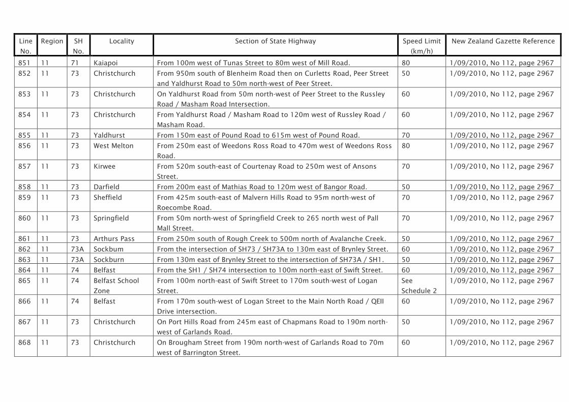
Line
No.
Region SH
No.
Locality Section of State Highway Speed Limit
(km/h)
New Zealand Gazette Reference
851 11 71 Kaiapoi From 100m west of Tunas Street to 80m west of Mill Road. 80 1/09/2010, No 112, page 2967
852 11 73 Christchurch From 950m south of Blenheim Road then on Curletts Road, Peer Street
and Yaldhurst Road to 50m north-west of Peer Street.
50 1/09/2010, No 112, page 2967
853 11 73 Christchurch On Yaldhurst Road from 50m north-west of Peer Street to the Russley
Road / Masham Road Intersection.
60 1/09/2010, No 112, page 2967
854 11 73 Christchurch From Yaldhurst Road / Masham Road to 120m west of Russley Road /
Masham Road.
60 1/09/2010, No 112, page 2967
855 11 73 Yaldhurst From 150m east of Pound Road to 615m west of Pound Road. 70 1/09/2010, No 112, page 2967
856 11 73 West Melton From 250m east of Weedons Ross Road to 470m west of Weedons Ross
Road.
80 1/09/2010, No 112, page 2967
857 11 73 Kirwee From 520m south-east of Courtenay Road to 250m west of Ansons
Street.
70 1/09/2010, No 112, page 2967
858 11 73 Darfield From 200m east of Mathias Road to 120m west of Bangor Road. 50 1/09/2010, No 112, page 2967
859 11 73 Sheffield From 425m south-east of Malvern Hills Road to 95m north-west of
Roecombe Road.
70 1/09/2010, No 112, page 2967
860 11 73 Springfield From 50m north-west of Springfield Creek to 265 north west of Pall
Mall Street.
70 1/09/2010, No 112, page 2967
861 11 73 Arthurs Pass From 250m south of Rough Creek to 500m north of Avalanche Creek. 50 1/09/2010, No 112, page 2967
862 11 73A Sockbum From the intersection of SH73 / SH73A to 130m east of Brynley Street. 60 1/09/2010, No 112, page 2967
863 11 73A Sockburn From 130m east of Brynley Street to the intersection of SH73A / SH1. 50 1/09/2010, No 112, page 2967
864 11 74 Belfast From the SH1 / SH74 intersection to 100m north-east of Swift Street. 60 1/09/2010, No 112, page 2967
865 11 74 Belfast School
Zone
From 100m north-east of Swift Street to 170m south-west of Logan
Street.
See
Schedule 2
1/09/2010, No 112, page 2967
866 11 74 Belfast From 170m south-west of Logan Street to the Main North Road / QEII
Drive intersection.
60 1/09/2010, No 112, page 2967
867 11 73 Christchurch On Port Hills Road from 245m east of Chapmans Road to 190m north-
west of Garlands Road.
50 1/09/2010, No 112, page 2967
868 11 73 Christchurch On Brougham Street from 190m north-west of Garlands Road to 70m
west of Barrington Street.
60 1/09/2010, No 112, page 2967

Line
No.
Region SH
No.
Locality Section of State Highway Speed Limit
(km/h)
New Zealand Gazette Reference
869 11 73 Christchurch On Curletts Road from 50m south of Lunns Road to 115m south of
Blenheim Road.
70 1/09/2010, No 112, page 2967
870 11 73 Christchurch On Curletts Road from 115m south of Blenheim Road to 90m north of
Blenheim Road.
1/09/2010, No 112, page 2967
871 11 73 Christchurch From 90m north of Blenheim Road on Curletts Road, Peer Street and
Yaldhurst Road to 50m north-west of Peer Street.
50 1/09/2010, No 112, page 2967
872 11 73 Christchurch On Yaldhurst Road from 50m north-west of Peer Street to 170m west of
the Russley Road / Masham Road intersection.
60 1/09/2010, No 112, page 2967
873 11 74 Christchurch On QEII Drive from the Main North Road to 220m east of the Main North
Road intersection.
50 1/09/2010, No 112, page 2967
874 11 74 Christchurch On QEII Drive 240m east of Main North Road to 150m west of Burwood
Road.
60 1/09/2010, No 112, page 2967
875 11 74 Christchurch On QEII Drive and Travis Road from 150m west of Burwood Road to
70m south of the Travis Road / Anzac Drive intersection.
50 1/09/2010, No 112, page 2967
876 11 74 Christchurch From 70m south of the Travis Road / Anzac Drive intersection, on
Bexley Road and Dyers Road to 100m north of Ferry Road.
70 1/09/2010, No 112, page 2967
877 11 74 Christchurch From 100m north of Ferry Road to 150m south of the Ferry Road
intersection.
50 1/09/2010, No 112, page 2967
878 11 74 Christchurch In the Lyttelton Tunnel from 50m north-west of the Heathcote Valley
Underpass to the Norwich Quay Intersection.
50 1/09/2010, No 112, page 2967
879 11 74 Christchurch On Norwich Quay from Tunnel Road to 270m north-east of Donald
Street.
50 1/09/2010, No 112, page 2967
880 11 74A Christchurch On Palinurus Road from the intersection with Dyers Road (SH74) to 50m
north-east of Ferry Road.
70 1/09/2010, No 112, page 2967
881 11 74A Christchurch From 50m north-east of Ferry Road on Palinurus Road, Rutherford
Street and Garlands Road to the Brougham Street / Opawa Road (SH73)
intersection.
50 1/09/2010, No 112, page 2967
882 11 75 Christchurch From 130m north of Hallswell Road to 50m south-west of Templetons
Road.
50 1/09/2010, No 112, page 2967
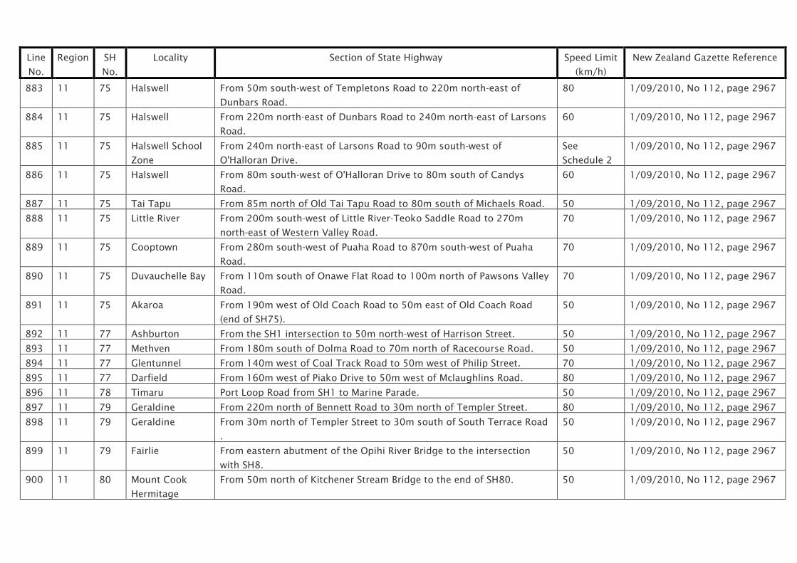
Line
No.
Region SH
No.
Locality Section of State Highway Speed Limit
(km/h)
New Zealand Gazette Reference
883 11 75 Halswell From 50m south-west of Templetons Road to 220m north-east of
Dunbars Road.
80 1/09/2010, No 112, page 2967
884 11 75 Halswell From 220m north-east of Dunbars Road to 240m north-east of Larsons
Road.
60 1/09/2010, No 112, page 2967
885 11 75 Halswell School
Zone
From 240m north-east of Larsons Road to 90m south-west of
O'Halloran Drive.
See
Schedule 2
1/09/2010, No 112, page 2967
886 11 75 Halswell From 80m south-west of O'Halloran Drive to 80m south of Candys
Road.
60 1/09/2010, No 112, page 2967
887 11 75 Tai Tapu From 85m north of Old Tai Tapu Road to 80m south of Michaels Road. 50 1/09/2010, No 112, page 2967
888 11 75 Little River From 200m south-west of Little River-Teoko Saddle Road to 270m
north-east of Western Valley Road.
70 1/09/2010, No 112, page 2967
889 11 75 Cooptown From 280m south-west of Puaha Road to 870m south-west of Puaha
Road.
70 1/09/2010, No 112, page 2967
890 11 75 Duvauchelle Bay From 110m south of Onawe Flat Road to 100m north of Pawsons Valley
Road.
70 1/09/2010, No 112, page 2967
891 11 75 Akaroa From 190m west of Old Coach Road to 50m east of Old Coach Road
(end of SH75).
50 1/09/2010, No 112, page 2967
892 11 77 Ashburton From the SH1 intersection to 50m north-west of Harrison Street. 50 1/09/2010, No 112, page 2967
893 11 77 Methven From 180m south of Dolma Road to 70m north of Racecourse Road. 50 1/09/2010, No 112, page 2967
894 11 77 Glentunnel From 140m west of Coal Track Road to 50m west of Philip Street. 70 1/09/2010, No 112, page 2967
895 11 77 Darfield From 160m west of Piako Drive to 50m west of Mclaughlins Road. 80 1/09/2010, No 112, page 2967
896 11 78 Timaru Port Loop Road from SH1 to Marine Parade. 50 1/09/2010, No 112, page 2967
897 11 79 Geraldine From 220m north of Bennett Road to 30m north of Templer Street. 80 1/09/2010, No 112, page 2967
898 11 79 Geraldine From 30m north of Templer Street to 30m south of South Terrace Road
.
50 1/09/2010, No 112, page 2967
899 11 79 Fairlie From eastern abutment of the Opihi River Bridge to the intersection
with SH8.
50 1/09/2010, No 112, page 2967
900 11 80 Mount Cook
Hermitage
From 50m north of Kitchener Stream Bridge to the end of SH80. 50 1/09/2010, No 112, page 2967

Line
No.
Region SH
No.
Locality Section of State Highway Speed Limit
(km/h)
New Zealand Gazette Reference
901 11 82 Waimate From 300m north-east of Regent Street to 60m north-east of Milford
Street.
70 1/09/2010, No 112, page 2967
902 11 82 Waimate From 60m north-east of Milford Street to 220m south of Massey Street. 50 1/09/2010, No 112, page 2967
903 11 82 Waimate From 220m south of Massey Street to 250m south of Settlement Road. 70 1/09/2010, No 112, page 2967
904 12 6 Inangahua From 600m north-east of Browns Creek Road to 60m west of Inangahua
Overbridge.
70 1/09/2010, No 112, page 2967
905 12 6 Charleston From 40m south of Cemetery Road to 120m south of Darkies Terrace. 80 1/09/2010, No 112, page 2967
906 12 6 Punakaiki From 240m north of Porarari River Bridge to 1.100km south of Porarari
Bridge.
70 1/09/2010, No 112, page 2967
907 12 6 Punakaiki From 1.100km south of the northern abutment of the Porarari Bridge to
180m north of the northern abutment of the Punakaiki Bridge.
60 1/09/2010, No 112, page 2967
908 12 6 Punakaiki From 180m north of Punakaiki River Bridge to 720m south of Punakaiki
River Bridge.
80 1/09/2010, No 112, page 2967
909 12 6 Rapahoe From 50m north of Holland Street to 50m south of Point Elizabeth
Walkway.
70 1/09/2010, No 112, page 2967
910 12 6 Runanga From 130m north of Ward Street to 370m south of Miller Street. 50 1/09/2010, No 112, page 2967
911 12 6 Greymouth From 120m east of Bright Street to 100m north of Weenink Road. 50 1/09/2010, No 112, page 2967
912 12 6 Greymouth From 100m north of Weenink Road to 20m north of Rata Street. 70 1/09/2010, No 112, page 2967
913 12 6 Karoro School
Zone
From 20m north of Rata Street to 30m north of Stanton Crescent. See
Schedule 2
1/09/2010, No 112, page 2967
914 12 6 Greymouth From 30m north of Stanton Crescent to 70m south of Clough Road. 70 1/09/2010, No 112, page 2967
915 12 6 Paroa From 70m south of Clough Road to 380m north of Rutherglen Road. 80 1/09/2010, No 112, page 2967
916 12 6 Paroa School
Zone
From 380m north of Rutherglen Road to 30m north of Rutherglen Road. See
Schedule 2
1/09/2010, No 112, page 2967
917 12 6 Paroa From 30m north of Rutherglen Road to 65m south of Rutherglen Road. 80 1/09/2010, No 112, page 2967
918 12 6 Arahura From 700m north of the northern abutment of the Arahura River Bridge
to 700m south of the northern abutment of the Arahura River Bridge.
80 1/09/2010, No 112, page 2967
919 12 6 Hokitika From 950m north-east of Richards Drive to 150m south of Richards
Drive.
80 1/09/2010, No 112, page 2967

Line
No.
Region SH
No.
Locality Section of State Highway Speed Limit
(km/h)
New Zealand Gazette Reference
920 12 6 Hokitika From 120m north of Hospital Hill Road to the northern abutment of the
Hokitika River Bridge.
50 1/09/2010, No 112, page 2967
921 12 6 Ross From 90m north-east of Stewart Street to 50m south-west of Tramway
Road.
50 1/09/2010, No 112, page 2967
922 12 6 Hari Hari From 1.450km east of Wanganui Flat Road to 50m west of Wanganui
Flat Road.
50 1/09/2010, No 112, page 2967
923 12 6 Whataroa From 800m east of Whataroa Flat Road to 400m east of Whataroa Flat
Road.
70 1/09/2010, No 112, page 2967
924 12 6 Whataroa From 400m east of Whataroa Flat Road to 20m south of Matainui Creek
Bridge.
50 1/09/2010, No 112, page 2967
925 12 6 Franz Josef From 280m south-west of Tatare River Bridge to 850m north of Waiho
River Bridge.
80 1/09/2010, No 112, page 2967
926 12 6 Franz Josef From 850m north of Waiho River Bridge to 420m west of Waiho River
Bridge.
50 1/09/2010, No 112, page 2967
927 12 6 Fox Glacier From 460m north-east of Cook Flat Road to 340m south of Cook Flat
Road.
50 1/09/2010, No 112, page 2967
928 12 7 Springs Junction From 400m south of the SH65 intersection to 300m west of the SH65
intersection.
70 1/09/2010, No 112, page 2967
929 12 7 Blacks Point From 480m south of Murray Creek Bridge to 310m north of Murray
Creek Bridge.
70 1/09/2010, No 112, page 2967
930 12 7 Reefton From 120m east of Donovan Street to 20m south of the Inangahua
River Bridge.
50 1/09/2010, No 112, page 2967
931 12 7 Reefton From 20m south of the Inangahua River Bridge to 60m north-west of
Soldiers Big River Road.
70 1/09/2010, No 112, page 2967
932 12 7 Ikamatua From 1.280km north Atarau Road to a point 910m south of Atarau
Road.
80 1/09/2010, No 112, page 2967
933 12 7 Totara Flat From 160m north-east of Granville Road to 950m south-west of
Granville Road.
80 1/09/2010, No 112, page 2967
934 12 7 Ahaura From the northern end of Ahaura River Bridge to 250m north of Ahaura 50 1/09/2010, No 112, page 2967

Line
No.
Region SH
No.
Locality Section of State Highway Speed Limit
(km/h)
New Zealand Gazette Reference
Kopara Road.
935 12 7 Ngahere From 310m south-west of Nelson Creek Road to 180m north of Red
Jacks Creek Bridge.
80 1/09/2010, No 112, page 2967
936 12 7 Stillwater From 60m east of Taylorville Road to 240m west of Arnold Valley Road. 70 1/09/2010, No 112, page 2967
937 12 7 Dobson From 350m north-east of Maori Street to 110m south-west of Moa
Street.
70 1/09/2010, No 112, page 2967
938 12 7 Kaiata From 250m east of Racecourse Creek Bridge to 520m north-west of
Omoto Valley Road.
70 1/09/2010, No 112, page 2967
939 12 7 Kaiata From 480m north-west of Omoto Valley Road to 340m east of SH6
intersection.
80 1/09/2010, No 112, page 2967
940 12 7 Greymouth From 340m east of the intersection of SH6 to the intersection with SH6. 70 1/09/2010, No 112, page 2967
941 12 65 Springs Junction From 600m north of the SH7 intersection to the end of SH7 at Springs
Junction.
70 1/09/2010, No 112, page 2967
942 12 67 Westport From 50m south-west of The Esplanade to 200 north-east of Orowaiti
Road.
50 1/09/2010, No 112, page 2967
943 12 67 Westport From 30m north of Domett Street to 200m north-east of Orowaiti Road. 70 1/09/2010, No 112, page 2967
944 12 67 Waimangaroa From 500m south-west of Waimangaroa-Dennison Road to 200m north-
east from Waimangaroa-Dennison Road.
70 1/09/2010, No 112, page 2967
945 12 67 Birchfield From 380m north of Big Ditch Bridge to 1.010km south of Jones Creek
Bridge.
80 1/09/2010, No 112, page 2967
946 12 67 Granity From 200m south-west of Twins Stream Bridge to 1.320km south-west
of Granity-Stockton Road.
70 1/09/2010, No 112, page 2967
947 12 67 Granity From 1.320km south-west of Granity-Stockton Road to 200m south-
west of Granity-Stockton Road.
50 1/09/2010, No 112, page 2967
948 12 67 Ngakawau /
Hector
From 200m south-west of Granity-Stockton Road to 1.280km north-east
of Ngakawau River Bridge.
70 1/09/2010, No 112, page 2967
949 12 67A Carters Beach From 80m east of Brunning Road to 920m west of Brunning Road. 50 1/09/2010, No 112, page 2967
950 12 69 Reefton From 160m north-west of Crampton Road to 120m south-east of
Andersons Road.
70 1/09/2010, No 112, page 2967

Line
No.
Region SH
No.
Locality Section of State Highway Speed Limit
(km/h)
New Zealand Gazette Reference
951 12 69 Reefton From 160m north-east of Crampton Road to the intersection with SH7. 50 1/09/2010, No 112, page 2967
952 12 73 Kumara From 230m south-east of Fifth Street to 40m north-west of Cashman
Street.
50 1/09/2010, No 112, page 2967
953 12 73 Kumara From 40m north-west of Cashman Street to 750m north-west of
Cashman Street.
70 1/09/2010, No 112, page 2967

NZTA Bylaw 2010/10
Schedule 1: Speed Limits for Specified Sections of State Highway
Otago / Southland State Highways
Line
No.
Region SH
No.
Locality Section of State Highway Speed Limit
(km/h)
New Zealand Gazette Reference
1001 13 1 Oamaru From 760m north of Fernbrook Road to 450m north of Fernbrook
Road.
70 1/09/2010, No 112, page 2967
1002 13 1 Oamaru From 450m north of Fernbrook Road to 205m east of Maudes Road. 50 1/09/2010, No 112, page 2967
1003 13 1 Oamaru, Alama From 205m east of Maudes Road to 330m west of Browns Road. 80 1/09/2010, No 112, page 2967
1004 13 1 Maheno From 300m north of Maheno-Kakanui Road to 360m south of Gifford
Street.
70 1/09/2010, No 112, page 2967
1005 13 1 Herbert From 100m north-east of Cromarty Street to 150m south of Cullen
Street.
70 1/09/2010, No 112, page 2967
1006 13 1 Hampden From 50m north of Lancaster Street to 180m north of Monmouth
Street.
80 1/09/2010, No 112, page 2967
1007 13 1 Hampden From 180m north of Monmouth Street to 30m south of Nottingham
Street.
60 1/09/2010, No 112, page 2967
1008 13 1 Hampden From 170m south of Oakham Street to 50m south of Nottingham
Street.
70 1/09/2010, No 112, page 2967
1009 13 1 Palmerston From 420m north-east of Stour Street to 540m south-west of Thomas
Street.
50 1/09/2010, No 112, page 2967
1010 13 1 Palmerston From 540m west of Thomas Street to 200m south of District Road. 70 1/09/2010, No 112, page 2967
1011 13 1 Waikouaiti From 350m north of Glasgow Street to 10m east of Reid Street. 70 1/09/2010, No 112, page 2967
1012 13 1 Waikouaiti From 10m east of Reid Street to 60m west of Dame Street. 50 1/09/2010, No 112, page 2967
1013 13 1 Waikouaiti From 60m west of Dame Street to 130m east of Ramrock Road. 70 1/09/2010, No 112, page 2967
1014 13 1 Dunedin From 180m north of Pinehill Road to the Great King Street / North
Road / Cumberland Street intersection.
50 1/09/2010, No 112, page 2967
1015 13 1 Dunedin NORTHBOUND - from North Road to 80m south-west of Andersons Bay 50 1/09/2010, No 112, page 2967

Line
No.
Region SH
No.
Locality Section of State Highway Speed Limit
(km/h)
New Zealand Gazette Reference
Road.
1016 13 1 Dunedin SOUTHBOUND - from North Road to 10m south of Water Street. 50 1/09/2010, No 112, page 2967
1017 13 1 Dunedin SOUTHBOUND - from 10m south of Water Street to 80m south of
Andersons Bay Road.
60 1/09/2010, No 112, page 2967
1018 13 1 Dunedin From 80m south of Andersons Bay Road to 90m north of Barnes Drive. 80 1/09/2010, No 112, page 2967
1019 13 1 Dunedin From 90m north of Barnes Drive to 300m south of Mornington Road. 50 1/09/2010, No 112, page 2967
1020 13 1 East Taieri From 340m east of Riccarton Road to 470m west of Riccarton Road. 70 1/09/2010, No 112, page 2967
1021 13 1 Allanton From 290m north of Grey Street to 200m south of the SH86
intersection.
80 1/09/2010, No 112, page 2967
1022 13 1 Waihola From 70m north of Titri Road to 60m south of Castle Street. 70 1/09/2010, No 112, page 2967
1023 13 1 Milton From 280m north of Highgate Street to the northern end of Salmonds
Creek Bridge.
70 1/09/2010, No 112, page 2967
1024 13 1 Milton From the northern end of Salmonds Creek Bridge to 60m north of
Lowery Street.
50 1/09/2010, No 112, page 2967
1025 13 1 Balclutha From 250m east of Cherry Lane to 150m east of Gormack Street. 70 1/09/2010, No 112, page 2967
1026 13 1 Balclutha From 150m east of Gormack Street to 30m west of Michies Road. 50 1/09/2010, No 112, page 2967
1027 13 1 Balclutha From 30m west of Michies Road to 160m west of Balclutha-Waitepeka
Road.
70 1/09/2010, No 112, page 2967
1028 13 1 Clinton From 70m east of Bruce Street to 150m north-west of Side Street. 50 1/09/2010, No 112, page 2967
1029 13 6 Makarora West From 500m north of Rata Road to 300m south of Rata Road. 80 1/09/2010, No 112, page 2967
1030 13 6 Albert Town From 710m west of Alison Avenue to 370m north-east of Alison
Avenue.
70 1/09/2010, No 112, page 2967
1031 13 6 Wanaka From 400m north of SH84 intersection to 400m east of SH84
intersection.
80 1/09/2010, No 112, page 2967
1032 13 6 Luggate From 160m north of Church Road to 300m south of Church Road. 70 1/09/2010, No 112, page 2967
1033 13 6 Luggate From 300m south of Church Road to 110m south of Hopkins Street. 50 1/09/2010, No 112, page 2967
1034 13 6 Luggate From 110m south of Hopkins Street to 430m south of Hopkins Street. 70 1/09/2010, No 112, page 2967
1035 13 6 Lake Hayes From 300m east of the Arrowtown-Lake Hayes Road to 100m west of
Alec Robins Road.
80 1/09/2010, No 112, page 2967

Line
No.
Region SH
No.
Locality Section of State Highway Speed Limit
(km/h)
New Zealand Gazette Reference
1036 13 6 Frankton From 250m east of Glenda Drive to 470m east of Frankton Road
(SH6A).
80 1/09/2010, No 112, page 2967
1037 13 6 Frankton From 470m east of Frankton Road (SH6A) to 200m south of Frankton
Road (SH6A).
50 1/09/2010, No 112, page 2967
1038 13 6 Frankton From 200m south of Frankton Road (SH6A) to 170m south of
Peninsula Road.
70 1/09/2010, No 112, page 2967
1039 13 6 Kingston From 30m south of Glen Nevis South Road to 360m south of Kent
Street.
80 1/09/2010, No 112, page 2967
1040 13 6A Frankton From the intersection with Kawarau Road (SH6) to 50m west of Yewlett
Crescent.
50 1/09/2010, No 112, page 2967
1041 13 6A Queenstown From 50m west of Yewlett Crescent to 550m south-west of Hensman
Road.
70 1/09/2010, No 112, page 2967
1042 13 6A Queenstown From 550m south-west of Hensman Road to Beach Street (end of State
Highway).
50 1/09/2010, No 112, page 2967
1043 13 8 Omarama From 100m north-east of Airport Road to 240m north-east of the
intersection with SH83.
70 1/09/2010, No 112, page 2967
1044 13 8 Omarama From 240m north-east of the intersection with SH83 to 110m west of
Pinot Noir Court.
50 1/09/2010, No 112, page 2967
1045 13 8 Omarama From 110m west of Pinot Noir Court to 260m west of Broken Hut
Road.
70 1/09/2010, No 112, page 2967
1046 13 8 Tarras From 270m north-east of Munroes Lane to 90m south-west of Jolly
Road.
80 1/09/2010, No 112, page 2967
1047 13 8 Alexandra From 500m north-west of Boundary Road to 100m north-west of
Boundary Road.
70 1/09/2010, No 112, page 2967
1048 13 8 Alexandra From 100m north-west of Boundary Road to 180m south of
Earnscleugh Road.
50 1/09/2010, No 112, page 2967
1049 13 8 Alexandra From 180m south of Earnscleugh Road to 500m south of Earnscleugh
Road.
70 1/09/2010, No 112, page 2967
1050 13 8 Roxburgh From 840m south of Slaughterhouse Creek Bridge to 20m north of 80 1/09/2010, No 112, page 2967

Line
No.
Region SH
No.
Locality Section of State Highway Speed Limit
(km/h)
New Zealand Gazette Reference
Edinburgh Street.
1051 13 8 Roxburgh From 20m north of Edinburgh Street to 140m south of Smith Street. 50 1/09/2010, No 112, page 2967
1052 13 8 Roxburgh From 140m south of Smith Street to 1.140km south of Smith Street. 80 1/09/2010, No 112, page 2967
1053 13 8 Ettrick From 200m north-west of Marsh Road to 50m south-east of Clutha
Road.
80 1/09/2010, No 112, page 2967
1054 13 8 Lawrence From 20m west of Kilmarnock Street to 120m west of Ardrossan
Street.
70 1/09/2010, No 112, page 2967
1055 13 8 Lawrence From 120m west of Ardrossan Street to 30m east of Whitehaven
Street.
50 1/09/2010, No 112, page 2967
1056 13 8 Lawrence From 30m east of Whitehaven Street to 50m east of Breakneck Road. 70 1/09/2010, No 112, page 2967
1057 13 8B Cromwell From 500m west of the intersection with SH8 to 110m east of the
intersection with SH6.
80 1/09/2010, No 112, page 2967
1058 13 83 Duntroon From 20m east of the eastern abutment of the Maarewhenua River
Bridge to 275m west of Earthquake Road.
70 1/09/2010, No 112, page 2967
1059 13 83 Kurow From 60m south of Ferguson Street to 60m south of Fitzroy Street. 70 1/09/2010, No 112, page 2967
1060 13 83 Kurow From 60m south of Fitzroy Street to 410m north of Grey Street. 50 1/09/2010, No 112, page 2967
1061 13 83 Lake Waitaki From 320m north of the access road to Lake Waitaki Power Station to
910m north of the access road to Lake Waitaki Power Station.
70 1/09/2010, No 112, page 2967
1062 13 83 Otematata From 460m east of the east end of the Otematata River Bridge to
450m west of Loch Laird Road.
80 1/09/2010, No 112, page 2967
1063 13 83 Omarama From 50m east of Ahururi Drive to 120m west of Black Peak Road. 70 1/09/2010, No 112, page 2967
1064 13 83 Omarama From 120m west of Black Peak Road to the intersection with SH8. 50 1/09/2010, No 112, page 2967
1065 13 84 Wanaka From the SH6 intersection to 250m east of Anderson Road. 80 1/09/2010, No 112, page 2967
1066 13 84 Wanaka From 250m east of Anderson Road to the end of the State Highway. 50 1/09/2010, No 112, page 2967
1067 13 85 Palmerston From the intersection with SH1 to 20m north-west of Brough Street. 50 1/09/2010, No 112, page 2967
1068 13 85 Palmerston From 20m north of Brough Street to 420m north of Burraness Street. 70 1/09/2010, No 112, page 2967
1069 13 85 Dunback From 200m south of Ritchie Road to 490m north of Ritchie Road. 70 1/09/2010, No 112, page 2967
1070 13 85 Ranfurly From 170m north of Welles Street (along Northland Street) to the
Stuart Road / Welles Street intersection.
50 1/09/2010, No 112, page 2967

Line
No.
Region SH
No.
Locality Section of State Highway Speed Limit
(km/h)
New Zealand Gazette Reference
1071 13 85 Ranfurly From Stuart Road / Welles Street intersection to 100m north of Knox
Street.
70 1/09/2010, No 112, page 2967
1072 13 85 Omakau From 570m north-east of Harvey Street to 300m south-west of Wilton
Street.
70 1/09/2010, No 112, page 2967
1073 13 85 Alexandra From 220m north-east of Gilligans Gully Road to 70m north-east of
Samson Street.
70 1/09/2010, No 112, page 2967
1074 13 85 Alexandra From 70m north-east of Samson Street to the SH8 intersection. 50 1/09/2010, No 112, page 2967
1075 13 86 Allanton From the intersection with SH1 to 315m north of Douglas Street. 80 1/09/2010, No 112, page 2967
1076 13 86 Momona From 350m east of Bruce Street to the end of the State Highway at
Airport Drive.
70 1/09/2010, No 112, page 2967
1077 13 87 Mosgiel From 85m south of the southern abutment of the SH1 Mosgiel
Overbridge to 140m north of Eden Street.
50 1/09/2010, No 112, page 2967
1078 13 87 Mosgiel From 140m north of Eden Street to 220m west of Dukes Road. 80 1/09/2010, No 112, page 2967
1079 13 87 Outram From 270m north-east of Holyhead Street to 120m north-west of
Formby Street.
50 1/09/2010, No 112, page 2967
1080 13 87 Middlemarch From 50m south of South Road to 50m north of Cardigan Street. 50 1/09/2010, No 112, page 2967
1081 13 87 Hyde From 200m south of Cemetery Road to 800m north-west of Cemetery
Road.
80 1/09/2010, No 112, page 2967
1082 13 88 Dunedin From the intersection with Cumberland Street (SH1) to 240m east of
Leander Street.
50 1/09/2010, No 112, page 2967
1083 13 88 Dunedin From 240m east of Leander Street to 500m west of Tekapo Street. 80 1/09/2010, No 112, page 2967
1084 13 88 Dunedin From 500m west of Tekapo Street to 310m east of Jessie Street. 50 1/09/2010, No 112, page 2967
1085 13 88 Dunedin From 310m east of Jessie Street to 90m west of Wickliffe Terrace. 80 1/09/2010, No 112, page 2967
1086 13 88 Port Chalmers From 90m west of Wickliffe Terrace to Beach Street. 50 1/09/2010, No 112, page 2967
1087 13 90 Tapanui From 680m north of Sussex Street to 530m west of Kent Street. 50 1/09/2010, No 112, page 2967
1088 13 93 Clinton From SH1 to 80m south-west of Merrie Creek Road. 50 1/09/2010, No 112, page 2967
1089 14 1 Pukerau From 400m east of Kaiwera Road to 50m west of West Street. 80 1/09/2010, No 112, page 2967
1090 14 1 Gore From 130m north-east of Wentworth Street to 70m east of Huron
Street.
70 1/09/2010, No 112, page 2967

Line
No.
Region SH
No.
Locality Section of State Highway Speed Limit
(km/h)
New Zealand Gazette Reference
1091 14 1 Gore From 60m north-east of Huron Street to 75m south of Bury Street. 50 1/09/2010, No 112, page 2967
1092 14 1 Gore From 75m south of Bury Street to 90m south of Charlton Street. 70 1/09/2010, No 112, page 2967
1093 14 1 Mataura From 30m north of Dacre Street to 20m north of Glendhu Road. 70 1/09/2010, No 112, page 2967
1094 14 1 Mataura From 20m north of Glendhu Road to the northern abutment of the
Waimumu Stream Bridge.
50 1/09/2010, No 112, page 2967
1095 14 1 Edendale From 50m north of Crescent Road to 300m north of Ferry Road. 80 1/09/2010, No 112, page 2967
1096 14 1 Edendale From 300m north of Ferry Road to 580m west of Bath Lane. 50 1/09/2010, No 112, page 2967
1097 14 1 Woodlands From 70m north-east of Grove Bush-Woodlands Road to 40m south-
west of Woodlands Cemetery Road.
80 1/09/2010, No 112, page 2967
1098 14 1 Invercargill From 400m west of Mill Road South to 1.620km west of Mill Road
South.
80 1/09/2010, No 112, page 2967
1099 14 1 Invercargill From 400m north-east of Rockdale Road to Balmoral Road. 50 1/09/2010, No 112, page 2967
1100 14 1 Invercargill From Balmoral Drive to 30m south of Kew Road. 70 1/09/2010, No 112, page 2967
1101 14 1 Bluff From 120m west of McGorlick Street to the end of the State Highway. 50 1/09/2010, No 112, page 2967
1102 14 6 Garston From 560m north of The Terrace (north) to 100m south of The
Terrace (south).
80 1/09/2010, No 112, page 2967
1103 14 6 Athol From 30m east of Albion Street to 370m west of Clyde Street. 80 1/09/2010, No 112, page 2967
1104 14 6 Lumsden From 160m north-west of Marcion Street to 230m south of Hero
Street.
50 1/09/2010, No 112, page 2967
1105 14 6 Dipton From 340m east of Spirit Burn Road to 70m west of Dipton-Castlerock
Road.
70 1/09/2010, No 112, page 2967
1106 14 6 Centre Bush From 320m south of the Centre Bush / Shand Road intersection to
300m south of Hundred Line Road.
80 1/09/2010, No 112, page 2967
1107 14 6 Winton From 111m north of Welsh Road to 25m south of Dejoux Road. 50 1/09/2010, No 112, page 2967
1108 14 6 Invercargill From 250m north of Flora Road (Makarewa) to 200m north of West
Plains Road.
80 1/09/2010, No 112, page 2967
1109 14 6 Invercargill From 200m north of West Plains Road to the intersection with SH1. 50 1/09/2010, No 112, page 2967
1110 14 93 Mataura From 160m north-east of Stuart Street to the intersection with SH1. 50 1/09/2010, No 112, page 2967
1111 14 94 Gore From SH1 to 540m east of Waimea Street. 50 1/09/2010, No 112, page 2967

Line
No.
Region SH
No.
Locality Section of State Highway Speed Limit
(km/h)
New Zealand Gazette Reference
1112 14 94 Mandeville From 300m west of Hatfield Road to 130m west of Waimea Valley
Road.
80 1/09/2010, No 112, page 2967
1113 14 94 Riversdale From 40m south-east of Chester Street to 40m north-west of
Riversdale Waikaia Street.
50 1/09/2010, No 112, page 2967
1114 14 94 Lumsden From 380m south-east of Maria Street to 80m south-east of Maria
Street.
70 1/09/2010, No 112, page 2967
1115 14 94 Lumsden From 80m south-east from Maria Street to SH6. 50 1/09/2010, No 112, page 2967
1116 14 94 Mossburn From 50m east of Essex Street to 80m west of Cumberland Street. 50 1/09/2010, No 112, page 2967
1117 14 94 Te Anau From 640m east of the SH95 intersection to 140m east of the SH95
intersection.
80 1/09/2010, No 112, page 2967
1118 14 94 Te Anau From 140m east of the SH95 intersection to 90m east of Caswell
Road.
50 1/09/2010, No 112, page 2967
1119 14 94 Te Anau From 90m east of Caswell Road to 730m east of Caswell Road. 80 1/09/2010, No 112, page 2967
1120 14 94 Milford Sound From 400m east of the Deep Water Basin access to 50m east of the
airport access.
80 1/09/2010, No 112, page 2967
1121 14 94 Milford Sound From 50m east of the airport access to the end of the State Highway. 30 1/09/2010, No 112, page 2967
1122 14 95 Te Anau From the intersection with SH94 to 500m south-west of Lake Front
Drive.
50 1/09/2010, No 112, page 2967
1123 14 95 Te Anau From 500m south-west of the Lake Front Drive intersection to 100m
south-west of Charles Nairn Road.
80 1/09/2010, No 112, page 2967
1124 14 95 Manapouri From 980m north-east of Hillside Manapouri Road to 80m north-east
of Hillside Manapouri Road.
70 1/09/2010, No 112, page 2967
1125 14 96 Browns From 140m east of Limehills Browns Road to 75m west of Limeworks
Road.
80 1/09/2010, No 112, page 2967
1126 14 96 Winton From 30m east of Florence Road to the intersection with SH6. 50 1/09/2010, No 112, page 2967
1127 14 96 Nightcaps From 40m south-east of Nightcaps-Opio Road to Osbourne Terrace. 50 1/09/2010, No 112, page 2967
1128 14 96 Ohai From Duchess Street to 250m south-west of Cottage Road. 70 1/09/2010, No 112, page 2967
1129 14 97 Mossburn From 100m north of Dorset Street to the intersection with SH94. 50 1/09/2010, No 112, page 2967
1130 14 98 Lorneville From 445m east of the SH6 intersection to the SH6 intersection. 80 1/09/2010, No 112, page 2967
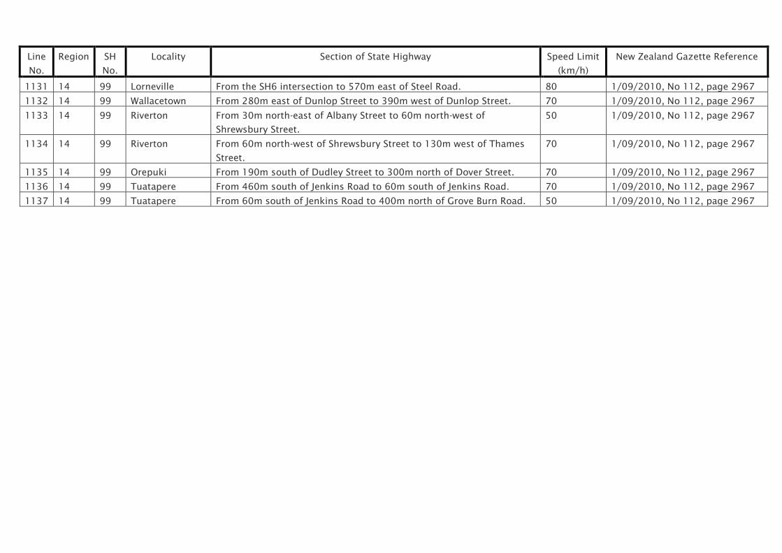
Line
No.
Region SH
No.
Locality Section of State Highway Speed Limit
(km/h)
New Zealand Gazette Reference
1131 14 99 Lorneville From the SH6 intersection to 570m east of Steel Road. 80 1/09/2010, No 112, page 2967
1132 14 99 Wallacetown From 280m east of Dunlop Street to 390m west of Dunlop Street. 70 1/09/2010, No 112, page 2967
1133 14 99 Riverton From 30m north-east of Albany Street to 60m north-west of
Shrewsbury Street.
50 1/09/2010, No 112, page 2967
1134 14 99 Riverton From 60m north-west of Shrewsbury Street to 130m west of Thames
Street.
70 1/09/2010, No 112, page 2967
1135 14 99 Orepuki From 190m south of Dudley Street to 300m north of Dover Street. 70 1/09/2010, No 112, page 2967
1136 14 99 Tuatapere From 460m south of Jenkins Road to 60m south of Jenkins Road. 70 1/09/2010, No 112, page 2967
1137 14 99 Tuatapere From 60m south of Jenkins Road to 400m north of Grove Burn Road. 50 1/09/2010, No 112, page 2967