By - USGS · By Max G 0 White and John M* Stevens ABSTRACT Reconnaissance for radioactive deposits...
43
UNCLASSIFIED Geology - Mineralogy This document consists of 22 pages Series A UNITED STATES DEPARTMENT OF THE INTERIOR GEOLOGICAL SURVEY RECONNAISSANCE FOR RADIOACTIVE DEPOSITS IN THE RUBY-POORMAN DISTRICT RUBY QUADRANGLE CENTRAL ALASKA, 1949* By Max G. White and John M* Stevens February 1953 Trace Elements Investigations Report 192 This preliminary report is dis- tributed without editorial and technical review for conformity with official standards and nomenclature. It is not for pub- lic inspection or quotation. This report concerns work done on behalf of the Division of Raw Materials of the U. S. Atomic Energy Commission.
Transcript of By - USGS · By Max G 0 White and John M* Stevens ABSTRACT Reconnaissance for radioactive deposits...

UNCLASSIFIED
Geology - Mineralogy
This document consists of 22 pages Series A
UNITED STATES DEPARTMENT OF THE INTERIOR
GEOLOGICAL SURVEY
RECONNAISSANCE FOR RADIOACTIVE DEPOSITS IN THE
RUBY-POORMAN DISTRICT RUBY QUADRANGLE
CENTRAL ALASKA, 1949*
By
Max G. White and John M* Stevens
February 1953
Trace Elements Investigations Report 192
This preliminary report is dis tributed without editorial and technical review for conformity with official standards and nomenclature. It is not for pub lic inspection or quotation.
This report concerns work done on behalf of the Division of Raw Materials of the U. S. Atomic Energy Commission.


USGS - TEI Report 192
GEOLOGY - MINERALOGY
Distribution (Series A) No* of copies
American Cyanamid Company, Winchester «...«... *...*! Argonne National Laboratory ...... ................ 1Atomic Energy Commission/ Washington ...«».....*..... 2Battelle Memorial Institute, Columbus . ...**«....*.«... 1Carbide and Carbon Chemicals, Company, Y-12 Area .*..»..».. 1 Division of Raw Materials, Grants .,...».............!Division of Raw Materials, Denver ................... 1Division of Raw Materials^ Mot Springs » , . . * . < .,..,.»... 1 Division of Raw Materials, New York ................. 6Division of Raw Materials, Salt Lake City *....». ,.»,....!Division of Raw Materials, Richfield ',.......*,.*...«.. 1Division of Raw Materials, Butte ........a........... 1Division of Raw Materials, Washington ....... a .».. 0 .... 3Dow Chemical Company, Pittsburg ................... 1Exploration Division, Grand Junction Operations Office. ....... 1Grand Junction Operations Office .«....,»*....*»..». 1Technicallnformation Service/ Oak Ridge ............... 6Tennessee Valley Authority, Wilson Dam . . * ............. 1Terr. Dept. Mines, Juneau (K H, Holdsworth) ....«.». ..»».!T*>r. Dept. Mines, Ketchikan (A. E. Glover) .»....*.,*.*. TTjrr, D|pt. j^ines, College (L* L. Patron) ............... 1Terr. Dipt. Mines, Nome (D. Jones)......... 0 ........ 1
U. S. Geological Survey:Mineral Deposits Branch, Washington .................. 1beochemistry and Petrology Branch, Washington ........... 0 1Geophysics Branch, Washington. ... ........... ....... 1Alaskan Geology Branch, Washington. . ... ............. 8G. O. Gates, San Francisco. .................... 2L. H. Saareld, Anchorage , . . .... 0 ............... 1C. L. Sainsbury, Juneau . . . ..................... 1R* M. Chapman, Fairbanks ..................... .1V. E. McKelvey, Washington .................... .1L. R. Page, Denver ...... .................... 1R» P* Fischer, Grand Junction ..................... 1A. E. Weissenborn, Spokane ............».........!TEPCO, Washington .*..,.......». * ...».,,».... 5
(Including master) " __60


CONTENTSPage
Abstract ..I....*.....*....***..**...**..*.*. 4
Introduction ....... 0 .......<>. ......<, .......... 5
Geology. ...........-....» = . »...»«... 0 .. ...^ 7Bedrock *..*..,..«,*.«*.,«. **. .,...»* ». 7Alluvium .....,,. . ..«,..,..«....*....,» 8
Mineral deposits » . * , * .».,,««., 4 .*..«»»*»..»..* «. 9
Radioactivity investigations .*««*.»*.. .»«».«* .*.. . 10Ruby area ...... .....*.**«« ».» **.. 10Long area ... 0 .... 0 ......... ........... 11
Granite on Birch and Straight Creeks » ............ 13Granite on upper Flint Creek . . , . * .. .......... 16
Po©rman area »*.»*. ,.* + »«.».....,..»..,... 20
Summary and conclusions . ... ....................... 21
Literature cited *»...«. .a.....*. ***. ............ 22
Figure 1 . Sketch map of the Ruby-Poorman district > Alaska, showinglocations of Birch Creek and upper Flint Creeks ........ 6
2. Geologic sketch map of Birch Creek, Ruby-Poorman, Alaska .I.,...*.....*.*......... 12
3. Geologic sketch map of upper Flint Creek/ Ruby-Poormandistrict, Alaska ..................... o ... 14
TABLES
Table 1. Data on samples from the vicinity of the Qrdnite on Birch andStraight Creeks, 1949 .,...*,.......,.,.»*, 15
2. Data on samples from the vicinity of the granite on upperFlint Creek and Monument Creeks, 1949 ,,..»....» « 17


4
RECONNAISSANCE FOR RADIOACTIVE DEPOSITS IN THE
RUBY-POORMAN DISTRICT, RUBY QUADRANGLE,
CENTRAL ALASKA, 1949
By Max G 0 White and John M* Stevens
ABSTRACT
Reconnaissance for radioactive deposits in the Ruby-Poorman district, Ruby
quadrangle, central Alaska during July 1949 showed that two small bodies of granite
in th$ Long area, about 30 miles south of Ruby, contain an average of 0.005 percent
equivalent uranium. This radioactivity is due chiefly to a uraniferous thorium
silicate, tentatively identified as uranothorite, which is disseminated in the granite.
Other minerals/ such as sphene, allanite, and zircon, that contain radioactive
elements as impurities, however, also contribute to the total radioactivity of the
granite* The uranothorite(?) contains about 57 percent thorium and 8 percent uranium*
Search for the bedrock source of a radioactive mineral of the spinel group
which occurs in placers on upper Solomon Creek in the Poorman area was unsuccessful.
Radiometric traversing indicated no anomalous radiation at a silver-bearing galena
deposit on New York Creek in the Ruby area.
Although it is believed that there is little possibility of commercial deposits
of uranium in the Ruby-Poorman district/ it should be noted that the heavy cover of
vegetation and alluvium prevents complete coverage of the district by radiometric
surveying,


INTRODUCTION
The Ruby-Poorman district (fig, 1) lies just south of the Yukon River mainly
along the divide between the Innoko and Nowitna Rivers in central Alaska, approxi
mately 230 miles west of Fairbanks» Ruby, Long, and Poorman are the only settle
ments in the area. Ruby (population 175) is located on the Yukon River and is the
point of entry for supplies to the mines in the district* Long is 28 miles south of
Ruby and is the center of most of the mining activity in the district, Doorman is about
25 miles south of Long and is located in the headwaters of the Innoko River drainage.
Long and Poorman are now virtually abandoned and have a combined population of
not more than 8 people* The Alaska Road Commission maintains a single-lane truck
road from Ruby to a point near Monument Creek (fig. 1). Formerly, this road extended
to Poorman, but maintenance on this stretch of road was abandoned a few years ago
and it is now impassable even to tractors *
Study of concentrates in the Geological Survey's Alaskan Geology Branch
collections showed the presence of radioactive minerals in placers on the upper part
of Solomon Creek near Poorman and near two small granite intrusives in the vicinity
of Long. The occurrence of these radioactive minerals, coupled with the facts that
tin and bismuth are also known in the placers, and a silver-bearing galena deposit is
located about 12 miles south of Ruby indicated that the district might be favorable
for the occurrence of uraniferous lodes. The party conducting the reconnaissance
consisted of M, G« White and J. M. Sfevens/ geologists, and Egil Salveson and
R, D, Olson, camp assistants. Ir worked in the area during the month of July 1949,
The accessibility of the area to jeep travel was of considerable aid to the party.
It is estimated that without a jeep for travel the ojcieration would have taken the entire


UNITED STATES DEPARTMENT OF THE INTERIOR
GEOLOGICAL SURVEY
TRACE ELEMENTS INVESTIGATIONS REPORT 192
FIGURE I
SKETCH MAP OF THE RUBY-POORMAN DISTRICT, ALASKA
SHOWING LOCATION OF BIRCH CREEK AND UPPER FLINT CREEK


season of three months rather than the one month actually used. This work was done
on behalf of the Division of Raw Materials of the U. S. Atomic Energy Commission.
GEOLOGY
The geology of the Ruby-Poorman district is known only on a reconnaissance
scale chiefly as a result of investigations by Eakin (1914, pp. 20U27), Mertie and
Harrington (1924, pp. 12-74), and Mertie (1936, pp. 130-143). The mantle of
residual soil covering most of the upper slopes and tops of all the hills; the depth of
alluvium covering all the lower slopes and stream valleys; and the blanket of moss,
low brush, and timber growth covering all but the highest hills make any geologic
investigation both difficult and time-consuming. Outcrops are rare, talus slides are
uncommon, and float rock is found usually only by digging through the moss into the
residual soil mantle.
Bedrock
The major part of the country rock in the Ruby-Poorman district consists of a
metamorphic rock complex including schist, phyllite, slqte, greenstone, quartzite,
chert, and limestone of Paleozoic age and possibly older From this complex it has
been possible to separate out and map separately the following formations: a recrystal-
Ifzed limestone of unknown age; Devonian rocks consisting mainly of limestone; and
a group of rocks that include greenstone, tuff, and chert» Granite bodies^ cropping
out in the headwaters of Flint Creek and on Birch Creek, are tentatively classified as
Mesozoic. The youngest rocks in the district are believed to be some soda-granite
dikes of possible Eocene age that occur in the vicinity of Poorman, and below Ruby on
the banks of the Yukon River.

8
Alluvium
Elevations within the district range from less than 400 feet above sea level
at Ruby to somewhat over 1,800 feet on some of the rounded hills south of Ruby.
The average sele Vat ion is probably between 1,300 and 1,400 feet. Alluvial deposits
consisting Mainly of Pleistocene silt with some gravel fill nearly all the stream
valleys almost to their heads and in places occur as high as 1,200 feet* Faintly
outlined terraces are found at elevations of 1,000 feet and higher along some of the
bedrock slopes and on many of the ridges. It is of some significance that the only
rock outcrops seen below that elevation are along stream cuts of Recent age,Essentially
all of the bedrock float found was in frost-heave mounds thrown up through the
alluvial mantle, Eakin (1916, p. 55) in discussing the origin of these alluvial >
deposits, widespread in this region of Alaska, states:
"The character of the silts indicates deposition in quiet waterj ,the distribution and form of the gravel terraces point to origin by beach action. As there are other corroborative lines of evidence pointing to the extensive inundation of the low-lying parts of the region, probably during and following the period of maximum glaciation in interior Alaska, the silts are interpreted as the deposits made by the debris-laden glacial waters and the high-lying gravel terraces as largely the product of beach action on the shores of lakes,that are now extinct. There are also more extensive high-level gravel deposits that are probably of fluvial origin, representing deltas built out into the margins of the ancient lakes by glacial and other streams."
According to Maddren (1910, p, 68) there was an interval following the
glaciation when downcutting by the present streams was very rapid, leaving some of
the preglacial gravel perched on the sides of the valleys as bench gravels. This
gravel appears on the west side of middle Flint Creek, and on lower Birch Creek,

MINERAL DEPOSITS
Placer gold has been the only mineral mined profitably in the Ruby-Poor man
district* Tin is abundant in many of the streams of the area, and though attempts have
been made to ship some of the cassiterite concentrate to the American market, none of
the attempts have been profitable. The lode source of both the tin and gold is
easily surmised to be from the hills and ridges adjacent to the placer deposits* How
ever/ the residual rock and vegeta} material on the ridges, and the alluvial mantle in
the stream valleys so effectively mask the bedrock in the district as to make any lode
prospecting too expensive and speculative an enterprise. A general description of the
lode and placer deposits in the district is given in a report prepared by Mertie (1936).
Development- work was done for a number of years on a silver-lead prospect on
New York Creek at the head of Beaver Creek (fig. 1) in the vicinity of Ruby. Attempts
to ship the ore were unprofitable, and the property was abandoned» This deposit
(Brown, 1926, pp. 146, 147; Mertie, 1936, pp.226, 227) consists of metalliferous
lenticular veins as much as several feet thick which lie parallel to the cleavage of
the enclosing micaceous quartz schist. The ore consists chiefly of silver-bearing
galena, much cerussite and limonite, minor amounts of rhodochrosite, manganese
oxides, calcite, and si den te, and traces of gold, quartz, pyrite, and ruby silver*i
Bismuth occurs at two localities: one in the vicinity of Ruby, at the head of
Glacier Creek (fig. 1) where a sluice-box concentrate fr$m placer-gold mining
contains 29 percent bismuth by chemical analysis; the other on lower Birch Creek in
the vicinity of Long, where Mertie (1936, p» 157) reported finding native bismuth in
the placer concentrates.


10
RADIOACTIVITY INVESTIGATIONS
The vegetal and alluvial mantle blanketing a large part of the Ruby-Poorman
district effectively absorbs most of the radiation from radioactive minerals in the
underlying rocks* Radiometric testing in the district, therefore, was efficient only
at the few localities where bedrock is exposed, in talus, or on the portions of the
ridges and upper valley slopes where the vegetation cover was not too Ihick to test
the underlying residuum either directly or with shallow test pits. For example, it is
estimated that only about 20 percent of the road between Ruby and Monument Creeks
(fig. 1) was satisfactorily tested by traversing with a jeep because of the thick vegetal
and alluvial mantle* Two probes one containing six 1- by 14-inch copper-walled
gamma tubes, the other with four 1- by 18-inch brass-walled gamma tubes, were
attached to standard commercial models of portable survey meters for jeep and back
packing traverses.
Ruby area
Fifteen placer concentrates from the Ruby area were in the Survey's Alaskan
concentrate collection before the present investigation. The creeks (fig. 1) from which
these samples had been obtained, the number of samples available, and the range in
equivalent uranium content of the samples from each creek are given below*
No* of Range in equivalent uraniumCreek concentrates content (percent)
Ruby Creek 2 0.000 - 0* 002Glacier Creek 6 .000 - .003Big Creek 2 .000 - .001Cox Pup (headwater tributary of 5 .001 - .006
Big Creek)


11
Because of the low radioactivity exhibited by these concentrates, reconnaissance in
the Ruby area was limited to the radiometric traversing along the road and the testing
of the silver-bearing galena lode on New York Creek (fig, 1) about 1,5 miles east
of the road. The road traversing revealed no significant radioactivity anomalies nor
was any significant amount of radioactive material found at the galena prospect. The
maximum equivalent uranium content of check samples taken at this prospect was
0*003 percent.
Long area
A total of 47 placer concentrates from the Long area (fig. 1) were available
for testing prior to the present investigation. The data on these concentrates are
summarized below:
No. of Range of equivalent uranium Creek concentrates content (percent)___
Birch Creek 13 0.000-0,013Lucky Creek 1 fl 001Glen $ulch t »006Flint Creek 1 ,43Trail Cree> 1 .000ty&nument Creek 1 *0320re(enstone Creek 3 .001 - *Q17Midnight'Creek 13 .000- ,002Short Creek 2 .000 - .001Fifth of July Creek 2 *001Willow Creek 1 0 00fLong Creek 5 .000- a 001Bear Gulch -3 .000- *002
It is apparent from this summary that the only concentrates with radioactivity of signi
ficance are from Birch, Flint, Monument, and Greenstone Creeks (fig» 1). These
streams drain the small areas of granite on Birch Creek (fig. 2) and on the divide


UNITED STATES
DEPARTMENT OF THE INTERIORGEOLOGICAL SURVEY
TRACE ELEMENTS INVESTIGATIONSREPORT I 9 2
FIGURE 2
Undifferenticrted Paleozoic rocks
GEOLOGIC SKETCH MAP OF BIRCH CREEK, RUBY-POORMAN DISTRICT
ALASKA


13
between Flint Creek and Monument and Greenstone Creeks (fig* 3), Consequently
most of the reconnaissance in the Long area was directed toward determining whether
the granite bodies were the source of the radioactive minerals in the placers, and,
if so, whether any zone of concentration of radioactive minerals existed within or
near the granites.
Granite on Birch and Straight Creeks
Data on the samples collected in the vicinity of the granite on Birch and
Straight Creeks are given in table 1. The location of these samples are shown on
figure 2. The six samples of the granite on these creeks (table 1) range from 0.003
to 0.006 percent (average 0.005 percent) in equivalent uranium content P The heavy-
mineral fractions (tho$e greater than 2.8 specific gravity) of these samples range from
0.007 to,0.036 percent equivalent uranium/ and average 0.027 percent equivalent
.uranium. Similar heavy-mineral fractions of panned concentrates from placers and
disintegrated granite in the vicinity of Birch Creek contain from 0.007 to 0.36
percent equivalent uranium, obviously higher because of the greater degree of con
centration. Sample no. 3456/ a panned placer concentrate, showed the highest
equivalent uranium content, 0.36 percent, of any of the samples collected in the
vicinity of Birch Creek. The radioactive elements are primarily in zircon and allanite,
although the sample contains minor amounts of hematite, and traces of sphene and
uranothorite(?) (see below) which are also radioactive. Although it is likely that
the bulk of the radioactivity in this sample is due chiefly to thorium, all of the
minerals mentioned give a positive, qualitative sodium-fluoride flux test for uranium.
Other minerals in the heavy fractions of the granite and placer concentrates from the
vicinity of the granite on Birch Creek are anatase, garnet, and ilmenite and a trace

14-
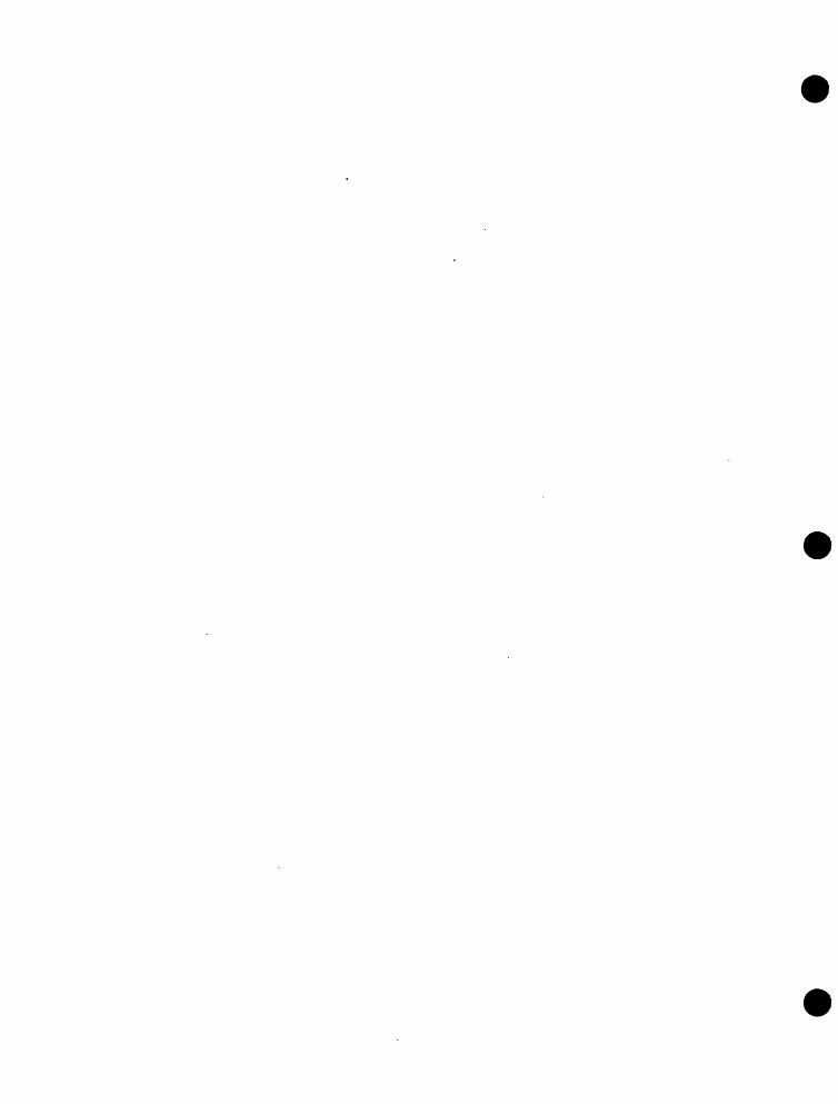
UNITED STATESDEPARTMENT OF THE INTERIOR
GEOLOGICAL SURVEY
TRACE ELEMENT INVESTIGATIONSREPORT 192
FIGURE 3
EXPLANATION
Mesozoic(?) granite
Undifferentiated Paleozoic rocks
3645
Sample locality 1949
GEOLOGIC SKETCH MAP OF UPPER FLINT CREEK
RUBY-POORMAN DISTRICT, ALASKA


15
Table 1. Data on samples from the vicinity of the granite on Birch and Straight Creek* t 1949.
Type of sample: Crushed rock Heavy-mineral fraction 3/ Sample no. - location J/ Percent eU2/ Percent eU Concentration ratio
Granite:
3471 - Birch Creek3472 - Do,3473 - PO. (fine
grained graniticdike)
3474 - Straight Creek3475 - Do.3476 Do.
0,006.006.006
.003,006.005
0.036,028,06
,0090 013.015
45s 135s 1
225s 1
13t1irji30S 1
Parlned concentrates from disintegrated granite:
3469 - Birch Creek3470 - Do.
Placer concentrates;
3449 - Birch Creek3455 - PO.3456 ? Do.3477 - Straight Creek
__
.»**wl U
*. _!
.30»22
,007.024.36.15
15,300?!i 1,000*1
very high2,300-12 7 7QO;1
640sl
I/ See also figure 22/ eU - equivalent uranium3/ That greater than 2*8 specific gravity


16
of malachite*
Granite on upper Flint Creek
Data on the samples collected from the vicinity of the granite body on upper
Flint Creek are given in table 2; the locations of the samples are shown on figure 3*
The equivalent uranium content of 12 samples from this granite ranges from 0.003 to
0.008 percent and averages 0.005 percent. The range in equivalent uranium content
of the heavy-mineral fractions (those greater than 2 0 8 specific gravity) of the 12
samples is 0 0 015 to 0.15 percent; the average is 0*037 percent,, This average is
higher than that of the granite on Birch Creek because of one heavy fraction, that of
sample 3505, which contains 0* 15 percent equivalent uranium* If this fraction is not
considered in the range and average, the results (range 0 D 015-0»05 percent equivalent
uranium; average 0,026 percent equivalent uranium) are closely comparable to the
range and average for the granite on Birch Creek. It is likely that this relatively
greater radioactivity in the heavy fraction of sample 3505 is due to the occurrence of
fewer non-radioactive minerals in proportion to the radioactive minerals rather than a
greater overall content of the radioactive minerals* This is a Ss© suggested by the fact
that the radioactivity of the unconcentrated granite at this point is the same as the
average of the granite (0.005 percent equivalent uraniurn) 0
In addition to sampling the granite itself/ panned concentrates were taken of
stream gravels on Flint and Monument Creeks and wash from the disintegrated granites
at the head of Flint Creek, The heavy-mineral fractions of these samples show the
consistently relatively higher equivalent uranium content that would be expected with
the greater degree of concentration (table 2).


17
Table 2. Data on samples from the vicinity of the granite on upper Flint and Monument Creeks/ 1949.
Crushed rock Heavy-mineral fraction 2/ Sample no. percent eU !/ Percent eU Concentration Ratio
Flint Creek (locations plotted on figure 3
Granite samples;
3484 0,005 0.015 99;!3485 ,006 .019 9*13493 .008 .025 6S 13494 .005 o024 40? 13497 ,004 .026 150:13498 .003 .024 6&13499 .004 .043 100-13500 .006 ,021 12Q3 13501 .005 .050 75? 13503 ,005 ,iD30 1& 13505 .005 J5 2 f 85Qsl3684 .005 .015 20s 1
Panned concentrates from granite wash;
3504 0*75 5,000;13506 -- .31 8,200*1
Panned concentrates from creek grovels;
3478 0.11 1,250s 13481 ~ 0 12 650j]3482 ,224 1,450;!3486 ,70 1/OOOtl3487 0 025 2,700;13488 0 26 1,100:13490 0 62 680*13492 ,02 640s 13496 .93 1,600;!3507 1,63 3,800;!3508 .46 4,200s!3509 0 64 3,700;!3645 .065 1,250s!3687 .20 4,500S 1
!/ eU - equivalent uranium2/ That greater than 2*8 specific gravity


18
Table 2* Data on samples from the vicinity of the granite on upper Flint and Monument Creeks/ 1949 (Continued )«
Monument Creek (locations plotted on figure 3)
Prom creek gravels;
3511 0,086 High3512 .001 Do.3513 .002 290:13515 .14 9,000:1


19
The radioactivity of the granite on upper Flint Creek and of the placers and
wash derived from the granite is due chiefly to a uraniferous thorium silicate,
tentatively identified as uranothorite, although the heavy fractions also contain
much sphene, allanite, and zircon, which also contribute to the total radioactivity
of the samples because they contain radioactive elements as impurities* Magnetite
and ilmenite are also found in the heavy-mineral fractions..
The uranothorire(?) is dark green with a vitreous to dull luster* It is
isotropic and has an index of refraction near 1.86. Following is a spectrographic
analysis on se fee ted grains from sample 3507, the heavy-mineral fraction of which
contains 1.53 percent equivalent uranium by radiometric analyses and 8 percent of
the uranothorite(?) as estimated by visual inspection,
Over 10 percent
thorium silicon
0« 1 - 1.0 percent
bismuth cobalt iron tin
0.01 - 0.1 percent
aluminumceriumcoppermagnesiummolybdenumpotassiumsilversodium
In addition to the above elements the mineral contains 8 0 2 percent uranium
(determined chemically). Phair and Shimamoto (1952, p 8 662) show the thorium


20
content as 56*6 percent*
Analytical spectrographfc analyses on what is apparently the same mineral
from other samples (no. 3496 from Flint Creek, and no. 3477 from Birch Creek) show
yttrium^) as a minor constituent. The samples from Monument Creek (0.032 percent
equivalent uranium) and Flint Creek (0.43 percent equivalent uranium) obtained
before 1949 contain a green uraniferous thorium-yttrium silicate which was tentatively
identified prior to this study as yttrfcfKte. It is likely/ however, that this mineral
is the uranothorite(?) discussed above.
The uranothorite(?) and the other radioactive minerals mentioned above are
disseminated accessory minerals of the granite, which is typically coarse-grained and
porphyritic. No zones of high concentration were found. The uranothorite(?) appears
to be less abundant in a minor fine-grained facies of the granite than in the large
mass of coarse-grained rock.
Poorman area
Data on placer concentrates from the Poorman area (fig. 1) available for
study prior to 1949 are summarized below.
No. of Range in equivalent uranium content Creek concentrates _______(percent)________
Poorman Creek 5 0,000 - 0.006Solomon Creek 3 .002 - .056Flat Creek 1 .001Moose Creek 1 .000Tamarack Creek 1 .001Spruce Creek 1 .004
From this summary it appears that the only radioactivity of significance in concen
trates from the Poorman area is in the samples from Solomon Creek. The most radio-


21
active sample came from the uppe&art of the creek. However, radiometric traversing
in the upper valley of Solomon Creek and along adjacent divides failed to detect any
significant radioactivity. Mineralogic study of the placer concentrate from Solomon
Creek showing the greatest radioactivity (0.056 percent equivalent uranium) found
that the radioactivity there is due to a uraniferous mineral of the spinel group,
Qualitative spectrographic analysis of the mineral shows aluminurn, chromium, iron,
magnesium, titanium, and rare earths as major constituents.
SUMMARY AND CONCLUSIONS
Two small bodies of granite in the vicinity of Long in the Ruby-Poorman
district contain an average of 0.005 percent equivalent uranium. Although the radio
activity is due chiefly to a uraniferous thorium silicate, tentatively identified as
uranothorite, radioactive allanite, hematite, sphene, and zircon also contributed to
the total radioactivity.
Radiometric tests in the vicinity of a silver-lead lode 12 miles south of Ruby
found no anomalous radiation at that locality. Search for the bedrock source of a
radioactive spinel previously found in placers on Solomon Creek in the Poorman area
was unsuccessful.
It is concluded from this investigation that there is little likelihood of finding
uranium deposits of commercial grade in the Ruby-Poorman district. It should be
noted, however, that much of the district is heavily covered with vegetation and
alluvium, which prevents the satisfactory use of portable survey meters to detect
radiation.


22
LITERATURE CITED
Brown, J* S., 1926, Silver-lead prospects near Ruby (Alaska): U. S. Geol. Survey Bull. 783-D, pp. 145-150*
Eakin, KU M., 1914, The Iditarod-Ruby region, Alaska: U« S* Geol. Survey Bull. 578,
________ , 1916, The Yukon-Koyukuk region/ Alaska: U. S» Geoi. Survey Bull631.
Maddren, A. G», 1910, The Innoko gold placer district, Alaska? U« S« Geol. Survey Bull, 410.
Mertie, J* B., Jr., 1936, Mineral deposits of the Ruby-Kuskokwim region (Alaska); U. S. Geol. Survey Bull. 864-C, pp. 115-255.
Mertie, J. B., Jr«, and Harrington, G. L», 1924, The Ruby-Kuskokwim region, Alaska: U. S. Geol. Survey Bull. 754.
Phair, George, and Shimamoto, Kiyoko Onoda, 1952, Hydrothermal uranothorite in fluorife breccras from the Blue Jay mine, Jamestown, Boulder County, Colorado: American Mineralogist, vol. 37, no. 7, pp. 659r666.


![Ruby on Rails [ Ruby On Rails.ppt ] - [Ruby - [Ruby-Doc.org ...](https://static.fdocuments.in/doc/165x107/5491e450b479597e6a8b57d5/ruby-on-rails-ruby-on-railsppt-ruby-ruby-docorg-.jpg)