by - USGS · 2010-12-15 · and does not imply endorsement by the USGS. 1 USGS MS 925 Reston, Va....
26
DEPARTMENT OF THE INTERIOR U.S. GEOLOGICAL SURVEY Preliminary results of coring of the Furlong Fault near Lake Aquetong, New Hope, Pennsylvania by Nicholas M. Ratcliffe' William C. Burton With section on geophysical logging by Roger N. Anderson and Daniel Moos Lamont-Doherty Geological Observatory of Columbia University Palisades, N.Y. 10964 Open-File Report 86-43 Prepared in cooperation with the Pennsylvania Bureau of Topographic and Geologic Survey This report is preliminary and has not been reviewed for conformity with U.S. Geological Survey editorial standards and stratigraphic nomenclature. Any use of trade names is for descriptive purposes only and does not imply endorsement by the USGS. 1 USGS MS 925 Reston, Va. 22092
Transcript of by - USGS · 2010-12-15 · and does not imply endorsement by the USGS. 1 USGS MS 925 Reston, Va....
DEPARTMENT OF THE INTERIOR
U.S. GEOLOGICAL SURVEY
Preliminary results of coringof the Furlong Fault near
Lake Aquetong, New Hope, Pennsylvania
byNicholas M. Ratcliffe' William C. Burton
With section ongeophysical logging by
Roger N. Andersonand
Daniel MoosLamont-Doherty Geological
Observatory of Columbia UniversityPalisades, N.Y. 10964
Open-File Report 86-43
Prepared in cooperation with the Pennsylvania Bureau of Topographic and Geologic Survey
This report is preliminary and has not been reviewed for conformity with U.S. Geological Survey editorial standards and stratigraphic nomenclature. Any use of trade names is for descriptive purposes only and does not imply endorsement by the USGS.
1 USGSMS 925Reston, Va. 22092

Table of Contents
Page
Introduction ................................................... 1
Location and description of drill holes.......................... 4
Results of coring and mineralogy of fault zone rocks............. 6
Interpretation................................................... 8
Geophysical data................................................. 10
Petrographic and x-ray mineralogy of core samples................ 10
Geophysical logging of Deer Park No. 1........................... 12
Geologic synthesis............................................... 12
Implications for seismicity...................................... 13
Appendix A: Core log of Deer Park No. 1......................... 14
Appendix B: Core log of Deer Park No. 2......................... 15
Appendix C: Well logs of Bucks County test wells
Nos. 3 and 5 (from Weston, 1969).................... 17
Appendix D: Geophysical log of Deer Park No. 1.................. 22
ILLUSTRATIONS
PageFigure 1. Regional geologic map showing location of major border faults
of the Newark basin, the Furlong Fault and location of the drill site near New Hope (site 9), in relation to other USGS drill sites, seismic lines, and earthquake epicenters along the margin of the Newark basin. 2
Figure 2. Geologic map and cross section of the New Hope area showing location of drill site and major faults. Map modified from Willard and others (1959). 3
Figure 3. Detailed site plan showing location of Deer Park Nos. 1 and2, Bucks Co. wells, and faults. 5
Figure 4. Detailed map of trench and vertical profile of cataclasite inthe Furlong fault zone near Deer Park No. 2. 7
Figure 5. Cross section through Deer Park Nos. 1 and 2 showing majorfaults and rock units. 9
Figure 6. Aeromagnetic map of the Buckingham area, showing routefollowed in truck magnetometer survey. Bold numbers refer todocumentation points along traverses (dashed lines).Contours in nanoteslas. From Bromery and others (1959a). 11
ii

INTRODUCTION
Two continuously cored vertical drill holes 716 and 355 feet deep were completed in July, 1985 across the Furlong fault near Lake Aquetong, New Hope, Pennsylvania, in the Lambert ville (Pennsylvania - New Jersey) 7 1/2-minute quadrangle. The cores were taken at two sites flanking Lower Mountain Road 1/2 mile south of the intersection with Route 202. Deer Park No. 1 is just east of the road and Deer Park No. 2 is 3W feet northwest of No. 1 (Fig. 3).
The Furlong fault is a major intrabasinal normal fault, down on the east-southeast side. The footwall exposes the Paleozoic carbonate rocks and floor of the Newark basin at Buckingham Mountain (Fig. 2). The hanging wall consists of red mudstones of the Upper Triassic Brunswick Formation intruded by major sills and dikes of Jurassic diabase.
Locally, barite and copper mineralization occurs along the Furlong fault and prospects are present in the immediate vicinity of the drill site. Barite, copper and granophyric intrusions are also known along the Flemington fault, a northeast continuation of the Furlong fault. The last movement on the Furlong-Flemington fault system post-dated intrusion of granophyre and diabase; however, earlier pre-diabase displacements are possible (Burton and Ratcliffe, unpublished data). Cumulative vertical displacement on the Furlong-Flemington fault system may be as great as two kilometers, as it affects rocks as young as the Lower Jurassic Orange Mountain Basalt, and as old as Upper Triassic Stockton Formation.
The drill sites were chosen to sample rocks of the hanging wall and footwall, to recover samples of the faults to determine their attitude and movement history, and to understand the relationship of faulting to mineralization .
The core sites are located about 1,000 feet northeast of two test water wells installed for the Bucks County Planning Commission by Roy Weston Environmental Scientists and Engineers in 1968 (Bucks County test wells Nos. 3 and 5). (Appendix C).
The information contained in this report is preliminary. Owing to the extensive cataclasis and subsequent mineralization within the fault zone, there is considerable uncertainty in the identification of the protoliths, especially of the feldspathic dolomitic rock above the diabase in both cores. Final evaluation will be based on petrographic, x-ray diffraction and chemical analysis of the samples now in progress.

oEpicenters
VPI & SU, USGS
VIBROSEIS Line
Major Triassic- Jurassic faults
USGS drillsite
N
O
O
FIGURE 2
LOCATION OF U.S.G.S. DRILL SITES AND VIBROSEIS LINES
Figure 1. Regional geologic map showing location of major border faults of the Newark basin, the Furlong Fault and location of the drill site near New Hope (site 9), in relation to other USGS drill sites, seismic lines, and earthquake epicenters along the margin of the Newark basin.

EXPLANATION
normal fault, bal on downthrown side
75'
NW
->1 kilometer
kilometers
Figure 2. Geologic map and cross section of the New Hope area showing location of drill site and major faults. Map modified from Willard and others (1959).

LOCATION AND DESCRIPTION OF DRILL HOLES
Deer Park No. 1
Core hole No. 1 was started in Triassic mudstones of the hanging wall block of the Furlong-Flemington fault east of Lower Mountain Road on the Stoop property. Collar elevation was approximately 208 feet. Four-inch casing was set to 60 feet and HQ (2 3/8 inch diameter) core taken to 200 feet and NQ (1 7/8 inch diameter) to 716 feet. Duplicate measurements of verticality using a spring loaded compass and inclinometer (Pajari instrument) gave a 5° inclination toward N. 38° E at 596 feet, indicating that the hole was substantially vertical. Recovery throughout was excellent with only minimal loss in softer zones. In Deer Park Hole No. 1, 12.1 ft. of core was not recovered out of 716 feet of core drilled, including about 6 1/2 feet during the changeover from HQ to NQ rod at 200 ft., plus isolated short segments (1-3 ft.) elsewhere, for a recovery percentage of 98%.
Deer Park No. 2
Deer Park No. 2 was sited 344 feet northwest of No. 1 at the west side of Lower Mountain Road near the site of a house excavation that exposed the cataclasite of the fault zone. Collar elevation was approximately 210 feet. Four-inch casing was set to 24 feet and NQ core (1 7/8 inch diameter) taken from 24 to 355 feet. Measurement of verticality using a Pajari instrument yielded values of 1° inclination to N. 40° E at 345 feet, indicating that the hole was vertical. Some loss of section occurred in the upper part of Deer Park No. 2 (above 100 feet), where isolated short segments of core (1-2 ft.) were lost for a total of 16.5 feet of no recovery out of 355 feet (95% recovery).
Excavation for a house foundation near Deer Park No. 2 exposed Triassic mudstone and cataclasite of the fault zone. The trenched area was mapped at 1 in to 10 ft and is shown in Figure 4.
Bucks County test wells
In 1968 two test wells for hydrologic studies were installed across the Furlong fault for the Bucks County Planning commission by R. F. Weston Environmental Scientists and Engineers. Bucks County test wells Nos. 3 and 5 are located about 1,000 feet southwest of Deer Park 1 and 2 as shown on Figures 2 and 3. Test well No. 5 is located 200 feet northwest of No. 3. No. 3 reached a depth of 518 feet in the Brunswick Formation, whereas No. 5 crossed the Furlong fault of a depth of 334 feet and extended to a total depth of 615 feet in dolostone and quartzite of the footwall. (Appendix C).

40°21'15"-
75°00
1000 2000
FEET Contour interval 20 feet
Figure 3.
LOCATION OF DEER PARK NO. 1 AND NO. 2 DRILL HOLES ON
FURLONG FAULTDetailed site plan showing location of Deer Park Nos. 1 and 2, Bucks Co. wells, and faults.

RESULTS OF CORING AND MINERALOGY OF FAULT ZONE ROCKS
In both Deer Park No. 1 and Deer Park No. 2 there was perfect recovery of the lower two major faults and partial recovery of the upper one (fig. 5). Deer Park No. 1 penetrated 458 feet of red and deep reddish brown mudstone of the Brunswick Formation (Appendix A). Bedding dips as much as 20° to southeast. Root casts and calcitic caliche zones are abundant. Between 458 and 490 feet a complexly faulted, brecciated, and mineralized zone containing clasts of light to dark gray or grayish green dolomitic, low-temperature-albite-calcite rock, possibly altered dolostone, was encountered. An apparent fault contact at 458* separates these rocks from mudstones above. The actual contact was not recovered or has been obscured by later mineralization. Cataclastic structures are abundant, expressed by chlorite-rich, hematite-coated and calcite- filled fractures that dip 45° to 55° southeast. Mineralization included introduction of pyrite, low albite, calcite, and dolomite into the rock.
At 490 feet a sharp fault contact with underlying altered coarse grained diabase is preserved. The actual fault consists of a 5 mm- wide zone of green chloritic gouge, bordered by 1-2 cm wide zones of hematization above and below. The diabase of the footwall is not chilled and the dolostone (?) clasts of the hanging wall are apparently not contact metamorphosed, indicating that the original intrusive contact of the diabase has been removed by faulting. j
From 490 feet to 712 feet altered coarse-grained diabase and granophyre were recovered. Veins of calcite, dolomite, low-albite, hematite and pyrite crosscut the diabase, which is locally cataclastic. Veins are brecciated by faults younger than the mineralization. Little primary mineralogy is preserved in the diabase, although igneous textures are readily apparent.
At 712 feet a sharp fault contact between diabase and dolostone is preserved that dips 50° to the southeast, and consists of a zone several centimeters thick of chloritic and hematitic breccia. Four feet of grey dolostone and white quartzite was recovered beneath the fault.Mineralization appears to stop abruptly beneath the fault.
iIn Deer Park No. 2 (Appendix B) red and dark brown mudstone and
cataclastic mudstone was recovered to a depth of 94 feet. From 94 feet to about 138 feet a mixture of white dolomite-albite rock and pyrite- rich mineralized material was recovered. The white rock may be highly mineralized fault breccia, although this is difficult to determine from present data. Beneath 138 feet a zone of dark green fine-grained diabase, probably representing a chilled margin, is present. From 164 to 171 feet a fault-bounded sliver of the white altered rock occurs, underlain by more green rock. Below 176 feet down to a depth of 311 feet coarse-grained but highly altered diabase is present. The upper contact of the coarse-grained diabase with chilled diabase also appears to be faulted, with subsequent mineralization. This diabase is largely replaced by calcite, dolomite, albite, and quartz, and veins of these minerals obscure the original texture. The contact at 311 feet with
H-
1 fD Jr
d-
O3
* ft)
fD
d-
(U13
H
-C
M
*J
fD»-
O
.
§
Bfjq
D
tu o
C
^J
M d-
d-
TN
0)
O
3
3
O
fD
3
*
3
p
0)
5
fD
d-T
H
-O
TJ
P
2!
O
O ^
ro
o (U d-
Bru
nsw
ick
Form
atio
nbl
ack,
sca
ly c
atac
lasi
teye
llow
go
ug
e/M
iner
afze
d(
10
fee
t
L_ o
underlying dolostone was perfectly recovered and is a sharp fault contact identical in nature to the lower fault in Deer Park No. 1 at 712 f . Cataclastic structures are strongly developed and dip ^5 to 55° to the southeast. Dolostone under the fault is less mineralized than rocks above the fault and a late, post-mineralization age for the fault seems likely, as seen in the lower fault of Deer Park No. 1.
Study of x-ray diffraction patterns from the diabase, altered fault brecciaC?), and the red mudstone of both cores reveals the ubiquitous presence of low-temperature albite and the absence of clay minerals except in some of the younger well-defined gouge zones. Veins within all rocks consist of various proportions of dolomite, calcite, low albite, chlorite, pyrite, hematite and quartz. Specular hematite and pyrite are abundant as minerals disseminated through the breccia zones.
Exposures of the fault zone in the excavation (Figure 4) show southeast dipping zones of gouge and black cataclasite. The contact with the grey mineralized rock was found in the northwest corner of the excavation.
iTaken together the data indicate that the Furlong fault is a
complex zone of subparallel faults that dip ^7° and 50° to the southeast.
INTERPRETATION
Preliminary interpretation of the data indicate that coarse-grained diabase is in fault contact with a mineralized fault breccia above and dolostone below; low-temperature mineralization post-dated some faulting, but later faults responsible for the present floor of the diabase body and part of its roof post-dated this mineralization. The data are consistent with intrusion of diabase into the fault zone following major down-faulting, although this interpretation is not confirmed by clearly preserved high temperature contact effects on the bordering rocks. Renewed fault movement then occurred after intrusion and mineralization.
Bucks County test wells 3 and 5 provide some control on the strike and dip of the Furlong fault. Well 3 did not penetrate the fault and stayed within mudstone to a depth of 518 feet. Test well 5, however, penetrated the fault at 310 to 3^6 feet based on the logs in Appendix C. No diabase apparently was present although the greenish serpentine- like material could have been chloritic cataclasite derived from diabase. These data indicate a dip in excess of ^5° for the Furlong fault.

BUCKINGHAM ANTICLINE BORDER
FAULTSNW
SEALEVEL
HOUSE EXCAVATION
(PROJECTED] i DP-2
LOWERMOUNTAIN
RD.
NEWARK BASIN
HIGHLY ALTERED ULT BRECCIA (?H
BRUNSWICK
FORMATION
(TRIASSIC)
CAMBRIAN
DOLOSTONE
HORIZONTAL EQUALS VERTICAL SCALE
r- o FEET
h 200
h 400
H 600
L- 800
CROSS SECTION THROUGH DEER PARK HOLES 1 & 2
SHOWING RESULTS OF CORE DRILLING
Figure 5. Cross section through Deer Park Nos, faults and rock units.
1 and 2 showing major
9
GEOPHYSICAL DATA
Aeromagnetic maps of the Bucks County area (Bromery and others, 1959a, b) (Figure 6) reveal a northeast-trending positive anomaly on the footwall block west of the Furlong fault and an arcuate positive anomaly associated with diabase on Solebury Mountain. In the vicinity of the drill site an elliptical positive anomaly with a closure of 1250 gammas is present, centered on the actual fault trace. The drill sites are situated on the east flank of this anomaly. I
A ground magnetic survey, utilizing a truck borne magnetometer, was conducted in July by Mark Gettings and Kevin Bond of the USGS. The route of this traverse is shown in Figure 6. Magnetic susceptibility of the cores of Nos. 1 and 2 were determined at one-foot intervals. Magnetization is pronounced in the diabase in both cores but is highly variable depending upon the degree of alteration of the primary ilmenite-magnetite in the diabase. t
Preliminary modeling by Gettings indicates that a highly magnetic source other than the diabase must underlie the Furlong fault. This magnetic rock could be highly magnetic basement rock or magnetite-rich skarn or a combination of both.
PETROGRAPHIC AND X-RAY MINERALOGY OF CORE SAMPLES
Approximately 55 thin sections and a equivalent number of x-ray diffraction powder patterns from the cores have been examined thus far. These results show that alteration of all rocks, but especially those within the fault zones, has been extensive.
The latest episode of mineralization recorded in the cores involving calcite-chlorite and quartz mineralization pervades all fault breccias. Grains of untwinned (nondeformed) calcite are common in veins. An earlier episode, consisting of albitization with associated chlorite-calcite-dolomite-pyrite mineralization, is responsible for replacement of carbonate rocks, red mudstone, diabase, and chilled diabase. Breccia zones and cataclasites derived from all the protoliths above have themselves been replaced by low temperature albite, dolomite, calcite, and chlorite in the same alteration event. Locally, near the chill diabase in Deer Park No. 2, 0.2 mm long flakes of white mica, phlogopite, and biotite are found within the altered breccia suggesting higher temperature alteration closest to the diabase.
The diabase in both cores is largely coarse-grained granophyric diabase consisting of large 3 mm non-zoned well-twinned plagioclase (An^g^g), and replaced monoclinic pyroxene. No primary pyroxene is preserved in any specimen, although euhedral, calcite-chlorite-hematite pseudomorphs after original, herringbone-twinned monocline pyroxene are abundant. Plagioclase is surrounded by micropegmatitic and granophyric quartz in plagioclase and microcline. Locally the coarse granophyre
10

Figure 6. Aeromagnetic map of the Buckingham area, showing routefollowed in truck magnetometer survey. Bold numbers refer to documentation points along traverses (dashed lines). Contours in nanoteslas. From Bromery and others (1959a).
11
contains a granular, quartz-rich, plagioclase-microcline residuum. The original pyroxene to plagioclase ratios vary from 50:50 in some chilled varieties to 5:95 in the coarse-grained granophyre and in irregular veinlets of fine-grained granophyre. Seventeen samples of altered rocks, diabase and vein assemblages have been submitted for whole rock and semiquantitative spectrographic analyses. These results will not be available until summer 1986.
GEOPHYSICAL LOGGING OF DEER PARK NO. 1
Geophysical logs of the Deer Park No. 1 well were run by Daniel Moos and Roger N. Anderson of the Borehole Research Group, Lamont- Doherty Geological Observatory during the Fall of 1985. The logs included caliper, natural gamma, delta-t (sonic velocity), and single- point resistance (Appendix D). A borehole televiewer (BHTV) log was also run to determine the orientations of planar features such as fractures and faults. The caliper log shows the change in hole size at 206 feet from HQ to NQ, and reveals that the well was in gauge throughout. The fault at 490 feet was not washed out by the drilling process (Appendix D, first column).
The upper fault at 490 feet which juxtaposes the mudstones of the hanging wall and the diabase of the foot wall is clearly indicated by a sharp drop in natural radioactivity across the contact (Appendix D, second column). This is presumably due to a higher potassium content in the mudstones. Sonic compressional velocity also drops at the fault contact, from about 5.5 km/s in the mudstone to less than 4.5 km/s in the diabase (Appendix D, third column). The anomalously low velocity in the diabase is due to its pervasive alteration. Otherwise, sonic velocity increases steadily with depth in both the diabase and the mudstone. This is probably the result of decreasing porosity with depth due to the closure of microcracks in response to increasing overburden pressure. Local low velocity zones may be caused by natural fractures, small fault zones, or groundwater channels. Stepwise changes in natural radioactivity and sonic velocity in the mudstones may be related to variations in grain size, mineralogy, alteration or brecciation. Although the resistivity log (Appendix D, column 4) is uncalibrated, small-scale variations in this log also reflect local changes in the properties of the in situ rock.
The lower fault at 712 feet was not sampled by these logs, as the drill hole only penetrated four feet below the fault, and the sensors are several feet above the bottom of each instrument package.
GEOLOGIC SYNTHESIS
Water well data from Bucks County test wells 3 and 5 and from the two core holes indicate that the Furlong fault strikes northeast and dips about 50° southeast. Mineralization involving low-temperature albite, dolomite, calcite, chlorite, quartz, pyrite, and hematite was extensive within the fault zone and affects rocks of the footwall and hanging wall. Late (post-mineralization) faulting downdropped the mineralized dolostone, the diabase, and the Brunswick Formation,
12

suggesting a complex history of faulting. One plausible interpretation of the data is down-faulting of Brunswick Formation against dolostone before intrusion of granophryic diabase into the fault zone, followed by widespread low temperature mineralization of the breccia zone, and late faulting to downdrop the mineralized material as a sliver, placing it in contact with relatively unaffected dolostone of the footwall.
IMPLICATIONS FOR SEISMICITY
No data found in this investigation require modern reactivation of the Furlong fault. Examination of the gouge material in the youngest fault zones reveal slickenlines and microcataclastic structures consistent with normal faulting. The lack of compressional structures or horizontal slickenlines suggests that the fault has not moved under the modern compressional stress field. Nonetheless, the Furlong fault can be shown to be a major north-to northeast-striking fault zone that dips 45° to the southeast and east which is therefore suitably oriented for reactivation in a strike slip or thrust mode in the modern compressional stress field that places the principal horizontal compressive stress in the northeast quadrant, at N. 55 E. ± 10° (Zoback, Anderson, and Moos, 1985).
References
Bromery, R. W., Henderson J. R. Jr., Zandle G. L. and others, 1959a, Aeromagnetic map of the Buckingham Quadrangle, Bucks County Pennsylvania: U.S. Geological Survey Geophysical Investigations Map GP-215.
Bromery, R. W., Henderson, J. R. Jr., Bennett, B. L. and others, 1959b, Aeromagnetic map of parts of the Lambertville and Stockton Quadrangles, Bucks County, Pennsylvania, and Hunterdon and Mercer Counties, New Jersey: U.S. Geological Survey Geophysical Investigations Map GP-216.
Weston, R. F. 1969, 1968 Interim Report on Ground Water Resources Bucks County Pennsylvania: unpublished report to the Bucks County Planning Commission, Doylestown, Pennsylvania
Willard, Bradford, Friedman, Jacob, McLaughlin, D. B., Ryan J. D.,Wherry, E. T., Peltier, L. C., and Gault, H. R., 1959, Geology and mineral Resources of Bucks County Pennsylvania: Pennsylvania Geological Survey Fourth Series Bulletin C9, 243 p.
Zoback, M. D., Anderson, R. N., and Moos, Daniel, 1985, In-situ stress measurements in a 1 Km-deep well near the Ramapo fault zone: Abstract , EOS, v. 66, no. 18, p. 363.
13
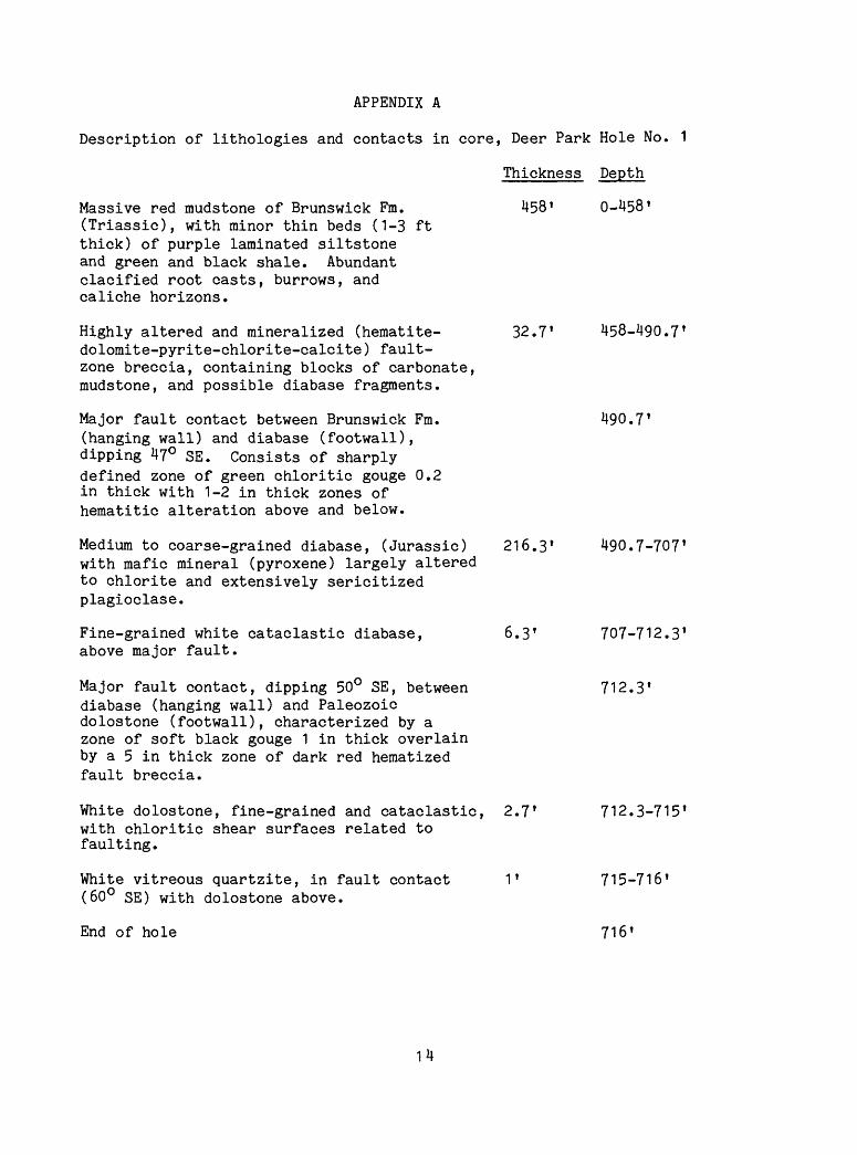
APPENDIX A
Description of lithologies and contacts in core, Deer Park Hole No. 1
Thickness Depth
Massive red mudstone of Brunswick Fm. 458 0-458 (Triassic), with minor thin beds (1-3 ftthick) of purple laminated siltstoneand green and black shale. Abundantclacified root casts, burrows, andcaliche horizons.
Highly altered and mineralized (hematite- 32.7* 458-490.7* dolomite-pyrite-chlorite-calcite) fault- zone breccia, containing blocks of carbonate, mudstone, and possible diabase fragments.
Major fault contact between Brunswick Fm. 490.7 *(hanging wall) and diabase (footwall),dipping 47° SE. Consists of sharplydefined zone of green chloritic gouge 0.2in thick with 1-2 in thick zones ofhematitic alteration above and below.
Medium to coarse-grained diabase, (Jurassic) 216.3* 490.7-707' with mafic mineral (pyroxene) largely altered to chlorite and extensively sericitized plagioclase.
Fine-grained white cataclastic diabase, 6.3 T 707-712.3* above major fault.
Major fault contact, dipping 50° SE, between 712.3*diabase (hanging wall) and Paleozoicdolostone (footwall), characterized by azone of soft black gouge 1 in thick overlainby a 5 in thick zone of dark red hematizedfault breccia.
White dolostone, fine-grained and cataclastic, 2.7* 712.3-715*with chloritic shear surfaces related tofaulting.
White vitreous quartzite, in fault contact 1* 715-716' (60° SE) with dolostone above.
End of hole 716
APPENDIX B
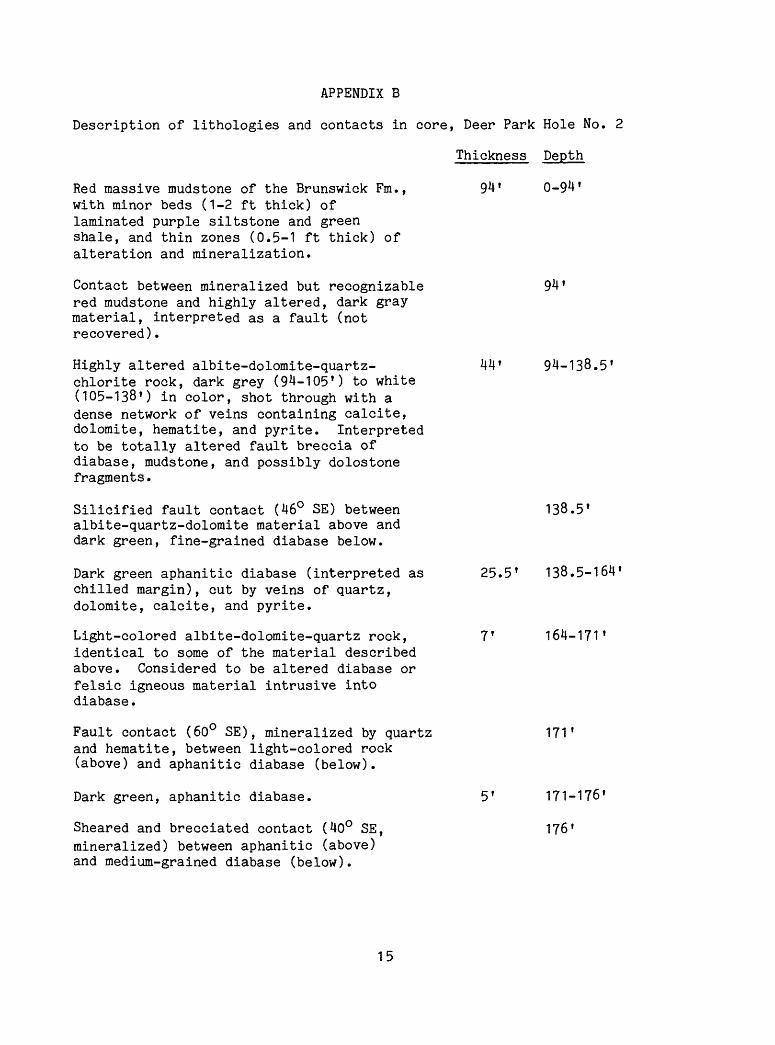
Description of lithologies and contacts in core, Deer Park Hole No. 2
Thickness Depth
Red massive mudstone of the Brunswick Fm., with minor beds (1-2 ft thick) of laminated purple siltstone and green shale, and thin zones (0.5-1 ft thick) of alteration and mineralization.
Contact between mineralized but recognizable red mudstone and highly altered, dark gray material, interpreted as a fault (not recovered).
Highly altered albite-dolomite-quartz- chlorite rock, dark grey (94-105') to white (105-138') in color, shot through with a dense network of veins containing calcite, dolomite, hematite, and pyrite. Interpreted to be totally altered fault breccia of diabase, mudstone, and possibly dolostone fragments.
Silicified fault contact (46° SE) between albite-quartz-dolomite material above and dark green, fine-grained diabase below.
Dark green aphanitic diabase (interpreted as chilled margin), cut by veins of quartz, dolomite, calcite, and pyrite.
Light-colored albite-dolomite-quartz rock, identical to some of the material described above. Considered to be altered diabase or felsic igneous material intrusive into diabase.
Fault contact (60° SE), mineralized by quartz and hematite, between light-colored rock (above) and aphanitic diabase (below).
Dark green, aphanitic diabase.
Sheared and brecciated contact (40° SE, mineralized) between aphanitic (above) and medium-grained diabase (below).
0-94
44' 94-138.5'
138.5
25.5 1 138.5-164'
164-171'
17T
51 171-176*
176 1
15
APPENDIX B (CONT.)
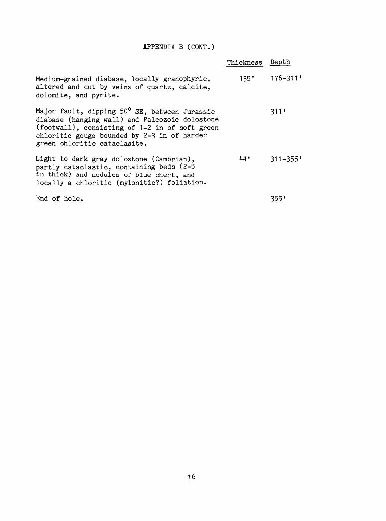
Thickness Depth
Medium-grained diabase, locally granophyric, 135' 176-311' altered and cut by veins of quartz, calcite, dolomite, and pyrite.
Major fault, dipping 50° SE, between Jurassic 311' diabase (hanging wall) and Paleozoic dolostone (footwall), consisting of 1-2 in of soft green chloritic gouge bounded by 2-3 in of harder green chloritic cataclasite.
Light to dark gray dolostone (Cambrian), UU f 311-355' partly cataclastic, containing beds (2-5 in thick) and nodules of blue chert, and locally a chloritic (mylonitic?) foliation.
End of hole. 355'
16
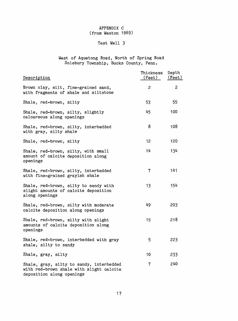
APPENDIX C (from Weston 1969)
Test Well 3
West of Aquetong Road, North of Spring Road Solebury Township, Bucks County, Penn.
Thickness Depth Description (Feet) (Feet)
Brown clay, silt, fine-grained sand, 2 2 with fragments of shale and siltstone
Shale, red-brown, silty 53 55
Shale, red-brown, silty, slightly 45 100 calcareous along openings
Shale, red-brown, silty, interbedded 8 108 with gray, silty shale
Shale, red-brown, silty 12 120
Shale, red-brown, silty, with small 14 134amount of calcite deposition alongopenings
Shale, red-brown, silty, interbedded 7 141 with fine-grained grayish shale
Shale, red-brown, silty to sandy with 13 154 slight amounts of calcite deposition along openings
Shale, red-brown, silty with moderate 49 203 calcite deposition along openings
Shale, red-brown, silty with slight 15 218amounts of calcite deposition alongopenings
Shale, red-brown, interbedded with gray 5 223 shale, silty to sandy
Shale, gray, silty 10 233
Shale, gray, silty to sandy, interbedded 7 240 with red-brown shale with slight calcite deposition along openings
17
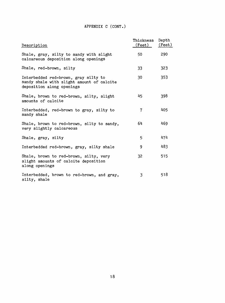
APPENDIX C (CONT.)
Thickness Depth Description (Feet) (Feet)
Shale, gray, silty to sandy with slight 50 290 calcareous deposition along openings
Shale, red-brown, silty 33 323
Interbedded red-brown, gray silty to 30 353 sandy shale with slight amount of oalcite deposition along openings
Shale, brown to red-brown, silty, slight 45 398 amounts of calcite
Interbedded, red-brown to gray, silty to 7 405 sandy shale
Shale, brown to red-brown, silty to sandy, 64 469 very slightly calcareous
Shale, gray, silty 5 4?4
Interbedded red-brown, gray, silty shale 9 483
Shale, brown to red-brown, silty, very 32 515 slight amounts of calcite deposition along openings
Interbedded, brown to red-brown, and gray, 3 518 silty, shale
18
APPENDIX C (CONT.)
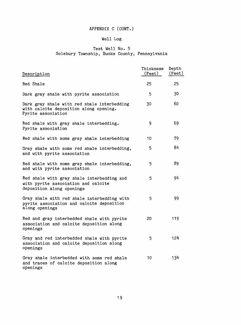
Well Log
Test Well No. 5 Solebury Township, Bucks County, Pennsylvania
Thickness Depth Description (Feet) (Feet)
Red Shale 25 25
Dark gray shale with pyrite association 5 30
Dark gray shale with red shale interbedding 30 60 with calcite deposition along opening. Pyrite association
Red shale with gray shale interbedding. 9 69 Pyrite association
Red shale with some gray shale interbedding 10 79
Gray shale with some red shale interbedding, 5 84 and with pyrite association
Red shale with some gray shale interbedding, 5 89 and with pyrite association
Red shale with gray shale interbedding and 5 94 with pyrite association and calcite deposition along openings
Gray shale with red shale interbedding with 5 99 pyrite association and calcite deposition along openings
Red and gray interbedded shale with pyrite 20 119association and calcite deposition alongopenings
Gray and red interbedded shale with pyrite 5 124association and calcite deposition alongopenings
Gray shale interbedded with some red shale 10 134and traces of calcite deposition alongopenings
19
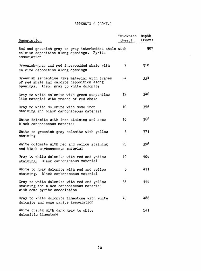
APPENDIX C (CONT.)
Thickness Depth Description (Feet) (Feet)
Red and greenish-gray to gray interbedded shale with 907calcite deposition along openings. Pyriteassociation
Greenish-gray and red interbedded shale with 3 310 calcite deposition along openings
Greenish serpentine like material with traces 24 334 of red shale and calcite deposition along openings. Also, gray to white dolomite
Gray to white dolomite with green serpentine 12 346 like material with traces of red shale
Gray to white dolomite with some iron 10 356 staining and black carbonaceous material
White dolomite with iron staining and some 10 366 black carbonaceous material
White to greenish-gray dolomite with yellow 5 371 staining
White dolomite with red and yellow staining 25 396 and black carbonaceous material
Gray to white dolomite with red and yellow 10 406 staining. Black carbonaceous material
White to gray dolomite with red and yellow 5 411 staining. Black carbonaceous material
Gray to white dolomite with red and yellow 35 446 staining and black carbonaceous material with some pyrite association
Gray to white dolomite limestone with white 40 486 dolomite and some pyrite association
White quartz with dark gray to white 541 dolomitic limestone
20

APPENDIX C (CONT.)
Thickness Depth Description (Feet) (Feet)
Dark gray to white dolomitic limestone with 30 571 quartz, brown staining, and black carbonaceous material
White quartz with brown-red staining, gray 44 615 to white dolomitic limestone. Black carbonaceous material with pyrite association.
21

APPE
ND
IX
D
WE
LL N
O.
OP
ER
AT
OR
WE
LL N
flME
FIE
LD
CO
UN
TYS
TflT
ELG
CflT
IGN
CO
UN
TRY
PR
OJE
CT
ELEVflTIONCOMMENTS
x* DPK-1
USGS RESTON
DEER PflRK
»1 RESEARCH
BUCKS
PENNSYLVflNIfl NEW HOPE
usn
0LOGGED 11/6/85
BY MOOS
flNDERSON SCHOLZ
WITNESSED BY
BILL BURTON
DEER PflRK
* 1
LOGGED 11/6/85
LOGO BOREHOLE RESEflRCH
GROUP
o_JQ_
CT OQ_ OLU
(log continued
next page)
II
^^(^^
\
o o
o
oOJ

AP
PE
ND
IX
D (c
on
t'd)
o
o
<no
o=ro
o
ino
o(O
II
o
o
Q_
tn cc
o
<no
<no
o
<x2C 2C <x
o«
(Ot\J