BY RICHARD P. FISCHER - U.S. Geological Survey ... P. FISCHER Prepared in cooperation with the STATE...
41
UNITED STATES DEPARTMENT OF THE INTERIOR Harold L. Ickes, Secretary GEOLOGICAL SURVEY W. C. Mendenhall, Director Bulletin 936-P VANADIUM DEPOSITS OF COLORADO AND UTAH A PRELIMINARY REPORT BY RICHARD P. FISCHER Prepared in cooperation with the STATE OF COLORADO and the COLORADO METAL MINING FUND Strategic Minerals Investigations, 1942 (Pages 363-394) UNITED STATES GOVERNMENT PRINTING OFFICE WASHINGTON : 1942 For sale by the Superintendent of Documents, Washington, D. C. ....... Price 30 cents
Transcript of BY RICHARD P. FISCHER - U.S. Geological Survey ... P. FISCHER Prepared in cooperation with the STATE...

UNITED STATES DEPARTMENT OF THE INTERIOR Harold L. Ickes, Secretary
GEOLOGICAL SURVEY W. C. Mendenhall, Director
Bulletin 936-P
VANADIUM DEPOSITS OF COLORADO AND UTAHA PRELIMINARY REPORT
BY RICHARD P. FISCHER
Prepared in cooperation with the
STATE OF COLORADO and theCOLORADO METAL MINING FUND
Strategic Minerals Investigations, 1942
(Pages 363-394)
UNITED STATES
GOVERNMENT PRINTING OFFICE
WASHINGTON : 1942
For sale by the Superintendent of Documents, Washington, D. C. ....... Price 30 cents


CONTENTS
Page
Abstract................................................. 363Introduction............................................. 364
Production........................................... 364Regional geology......................................... 365Ore deposits............................................. 366
Ore-bearing formations...*........................... 367Shinarump conglomerate.......................... 9 367Entrada sandstone................................ 367Morrison formation............................... 371
Mineralogy........................................... 376Ore.................................................. 379
Lithology........................................ 379Character .and distribution....................... 379
Ore bodies........................................... 382Uravan district.................................. 385
Origin and control of ore............................ 387Suggestions for prospecting...... 0 ....................... 389Mining and milling....................................... 393
Prospecting.......................................... 393Mining............................................... 394Milling.............................................. 394
ILLUSTRATIONS
Page
Plate 53. Index map of part of Colorado, Utah, and Ari zona, showing the location of the sig nificant vanadium deposits.................. 366
54. A, Photomicrograph of sandstone impregnated with vanadium-bearing hydrous micaj B, Typical face of vanadium ore................ 382
55. A, Zone of vanadium ore cutting across bed^ ding; 13, Thin zone of rich vanadium ore along contact of ore body and barren sand stone ....................................... 382
56. A, Parallel zones, resembling diffusion bands, of rich vanadium ore along the edge of an ore body; B, Lens of shale-pebble conglomer ate, in part mineralized and in part barren. 382
57. Geologic map and section of the Club group ofmines, Montrose County, Colorado............ 386
III

IV ILLUSTRATIONS
Page
Figure 43. East-west cross section through the Riflemine (after Blair Burwell).................. 372
Figure 44. Measured stratigraphic sections of theEntrada sandstone in the Placerville dis trict, showing the^position of the vana dium- and chromium-bearing layers........... 373
Figure 45. Hap of the Placerville district, showing the outcrops of the vanadium- and chromium- bearing layers.............................. 374
Figure 46. Cross-section of an ideal ore body............ 384Figure 47. Geologic map of the Uravan area, Montrose
County, Colorado............................ 386

VANADIUM DEPOSITS OF COLORADO AND UTAH
A PRELIMINARY REPORT
By Richard P. Fischer
ABSTRACT
Deposits of vanadium-bearing sandstone are widely distributed in western Colorado and eastern Utah and have been the principal domestic source of vanadium, uranium, and radium. Except during a few years when operations were relatively small, deposits at one or more places in this region have been intensively mined since 1909. Production has increased considerably each year since 1937.
Most of the deposits are in the Morrison formation, but there are two .important deposits in the Entrada sandstone and several small deposits in the Shinarump conglomerate. Recent X-ray studies indicate that the principal vanadium mineral, heretofore considered to be roscoelite, belongs to the hydrous mica group of clay minerals. This mineral, along with other vanadium minerals of minor importance, impregnates sandstone. Shale peb bles and clay films on bedding planes in ore-bearing sandstone are rich in absorbed vanadium, and fossil plants in and adjacent to ore bodies are richly mineralized with vanadium and uranium in places. Vanadium ore of milling grade contains from about 1 to 5 percent V^Oc, and most of it contains less than 1 percent UgOg. Ore containing as much as li percent UsOo 13 usually sold as uranium ore. The vanadium-bearing hydrous mica is in part uniformly disseminated through the sandstone and in part con centrated along bedding planes and in thin zones that cut across bedding. As the zones that cut across bedding are curved or wavy, they are called rolls by the miners.
The ore bodies are spotty and form irregularly tabular masses that lie essentially parallel to the sandstone beds, but they do not follow the beds in detail. They range in content from a few tons of ore to many thousand tons. The trend of many elon gate bodies is indicated by the orientation of the rolls within the ore, and this trend also suggests the probable alinement of any adjacent ore bodies; mapping of ore bodies and rolls is therefore an aid to prospecting and development.
No satisfactory explanation can yet be offered for the origin of these deposits. The ore bodies do not appear to have been localized by such geologic structures as fractures or folds, but within limited areas they are restricted to certain strati- graphic zones.
363

364 STRATEGIC MINERALS INVESTIGATIONS, 1942
INTRODUCTION
Deposits of vanadium-bearing sandstone, containing some
uranium and radium, are widely distributed in western Colorado
and eastern Utah, and some occur in northern Arizona (pi. 53).
These deposits have been the principal domestic source of vana
dium, uranium, and radium. In 1939 the Geological Survey, United
States Department of the Interior, in cooperation with the State
of Colorado and the Colorado Metal Mining Fund, began a geologic
study of these ores .in the western part of Montrose County,
Colo., where many of the largest known deposits of this type
have been found. The present report, which describes the
significant geologic features of these deposits, is based on
this study and on brief visits to many of the other vanadium-
producing areas in the region,,
The work was begun under the guidance of Mr. B. S. Butler
of the Geological Survey. S. P. St. John, Charles Meyer, 0. J.
Myers, and A. P. Butler, Jr., have assisted in the field work.
The producing companies and many individuals in the vanadium
region gave generous aid and cooperation. H. G. Ferguson and
F. C. Calkins contributed many helpful suggestions during the
preparation of the report.
Production
In 1899 a yellow mineral from the sandstones of the western4
part of Montrose County was found to contain uranium, vanadium,
and radium; and this mineral was named carnotite. From 1911 to
1923 ores containing carnotite were intensively rained in Montrose
County and adjacent areas; radium and uranium were the constitu
ents desired, but from 1915 to 1923 some vanadium was produced
as a byproduct. Mining of these ores practically ceased in
1923, when the Belgian Congo pitchblende began to supply radium.
Since 1937 these ores again have been intensively mined, but
VANADIUM DEPOSITS OF COLORADO AND UTAH 365
this time primarily for vanadium. Vanadium was produced from
vanadium-bearing sandstone at Placerville, Colo., from 1909 to
1923, and at Rifle, Colo., from 1925 to 1932. Vanadium ore was
being mined at both localities in 1941.
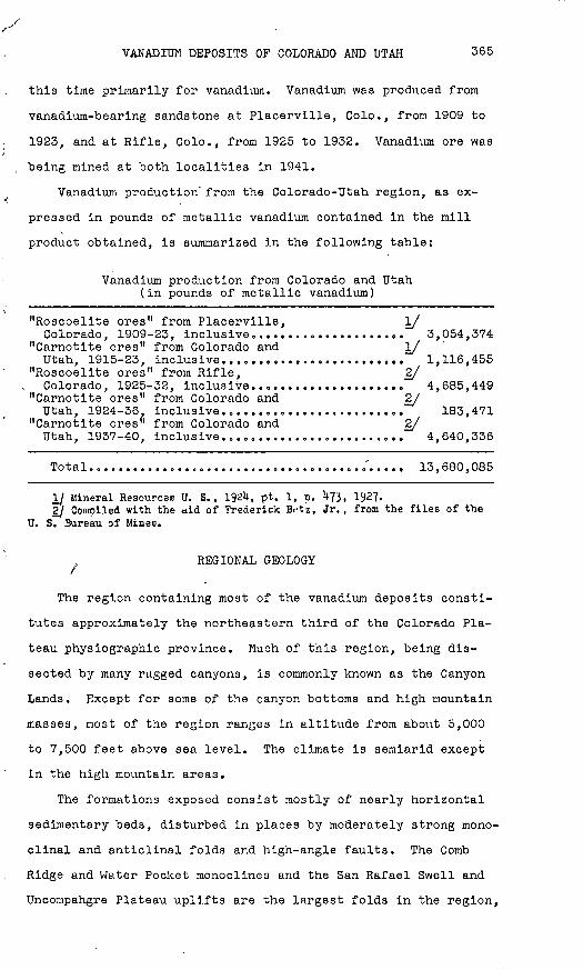
Vanadium production' from the Colorado-Utah region, as ex
pressed in pounds of metallic vanadium contained in the mill
product obtained, is summarized in the following table:
Vanadium production from Colorado and Utah (in pounds of metallic vanadium)
"Roscoelite ores" from Placerville, I/Colorado, 1909-23, inclusive..................... 3,054,374
"Carnotite ores" from Colorado and I/Utah, 1915-23, inclusive......................... 1,116,455
"Roscoelite ores" from Rifle, 2/Colorado, 1925-32, inclusive..................... 4,685,449
"Carnotite ores" from Colorado and 2/Utah, 1924-36. inclusive......................... 183,471
"Carnotite ores" from Colorado and 2/Utah, 1937-40, inclusive......................... 4,640,336
Total........................................... 13,680,085
i/ Mineral Resources U. S. , 1921*, pt. 1, p. U?3. 1927. 2j Compiled with the aid of Frederick Bet'z, Jr., from the files of the
U. S. Bureau of Mines.
REGIONAL GEOLOGY
The region containing most of the vanadium deposits consti
tutes approximately the northeastern third of the Colorado Pla
teau physiographic province. Much of this region, being dis
sected by many rugged canyons, is commonly known as the Canyon
Lands. Except for some of the canyon bottoms and high mountain
masses, most of the region ranges in altitude from about 5,000
to 7,500 feet above sea level. The climate is semiarid except
in the high mountain areas.
The formations exposed consist mostly of nearly horizontal
sedimentary beds, disturbed in places by moderately strong mono-
clinal and anticlinal folds and high-angle faults. The Comb
Ridge and Water Pocket monoclines and the San Rafael Swell and
Uncompahgre Plateau uplifts are the largest folds in the region,

366 STRATEGIC MINERALS INVESTIGATIONS, 1942
but strong anticlines underlie Paradox Valley, Spanish Valley,
and other similar topographic features in the vicinity of the
La Sal Mountains. Steeply dipping faults displace the beds
along the flanks of these folds in many places, and competent
sandstone beds in the vicinity of these folds are much jointed.
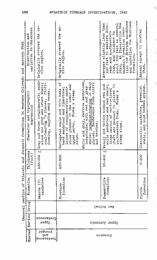
The sedimentary beds in western Colorado and eastern Utah
range in age from late Paleozoic to Tertiary. All known vanadium
deposits of economic importance are found in the Shinarump con
glomerate, of Triassic age, and the Entrada sandstone and Morri-
son formation, of Jurassic age. The lithologic features, topo
graphic expression, distribution, and variations in thickness of
the Triassic and Jurassic formations in this region are summa
rized in the table on pages 368-371,
Moderate-sized igneous bodies of Tertiary age have intruded
these sediments and are exposed in the La Sal, Abajo, El Late
(Ute), Carrizo, and Henry Mountains,
ORE DEPOSITS
The vanadium deposits of western Colorado, eastern Utah, and
northern Arizona, although of wide areal distribution, have a
narrow stratigraphic range. All known deposits of economic im
portance in the region are restricted to the Shinarump, Entrada,
and Morrison formations, and at many places the deposits are
largely or wholly confined to a single stratigraphic zone in one
of these formations. The ore, however, is not confined to a
single sandstone bed or lens. The ore is mostly sandstone im
pregnated with vanadium minerals, but shale pebbles and clay
films along bedding planes in 'the ore-bearing sandstone are rich
in absorbed vanadium, and fossil plants in and adjacent to ore
bodies are in places richly mineralized. As the vanadium con
tent of the ore is not uniform, highly selective mining is re
quired to obtain ore of the desired grade. Vanadium ore of
milling grade contains from about 1 to 5 percent V205 , and most

!O7<
EXPLANATION
Deposits in the Morrison formation*
Deposits in the Entrada/ sandstone
X Deposits in the Shinarump conglomerate
9 {9 20 30 4-0 50 MILES
EMERYS E V I E R
M O N TROS
4 OUP^AY \-
SAN MIGUEL
Cortez
MONTEZUMA
U TA H_ A RJJzfo N A " x
.'NAVAJCM A PACH E
\QT. 366}

VANADIUM DEPOSITS OP COLORADO AND UTAH 367
of it contains less than 1 percent UgOg. Ore containing as much
as if percent U 0Q is commonly sacked and sold separately as o o
uranium ore.
The ore bodies are .extremely spotty and form irregularly
tabular masses that lie essentially parallel to the sandstone
beds, but do not follow the beds in detail. In places, curved
or wavy structures in the ore, called rolls by the miners, are
oriented in a common direction, and this orientation may indi
cate the trend or elongation of the ore body,, Adjacent bodies
are also likely to be alined along this trend. The ore bodies
do not appear to have been localized by fractures or folds.
Ore-bearing formations
Shinarump conglomerate, The only known important deposit of
vanadium and uranium in the Shinarump conglomerate is at Temple
Mountain, in Emery County, Utah. This deposit has not beenI/
visited by the writer but has been described by Hess. Small
deposits in the Shinarump conglomerate occur in southern Utah
and northern Arizona (pi. 53). These have some features in com
mon with the deposits in the Morrison formation.
Entrada sandstone. At the U. S. Vanadium Corporation's mine,
about 12 miles northeast of Rifle, Colo., most of the ore is in
the lower part of a 20- or 30-foot bed of cross-bedded, gray
sandstone, included in the Entrada sandstone in this report.
This bed lies on the Dolores formation, and it is overlain by
about 100 feet of characteristic Entrada sandstone. A cross2/
section through the mine, drawn by Burwell, shows a close rela
tionship between the distribution of the ore and the cross-
bedding (fig. 43); however, the mineralized sandstone that ex
tends laterally from the ore body forms a single slightly
iy Hees, F. L., Uranium-bearing asphaltite sediments of Utah: Eng. and Win. Jour.-Press, vol. llU, pp. 212-2^6, 1922.
2j Burwell, Blair, Mining methods and costs at the vanadium mine of the U. S. Vanadium Corooration, Rifle, Colo.: U. 3. Bur. Mines Inf. Circ. 6662, fig. 2, 1932.
488684 O - 42 - 2
368 STRATEGIC MINERALS INVESTIGATIONS, 1942
f*
cd4J
d04JCOcd0 ddcd
dcdpi,oHOO
d04J CO05
H
COd0
H4^
g^0
O HCOCOcd
§
ddcdo H
COcocd
9-1
CH0
do H4JO0co
HcdH0dd)
C5
COCO0 d d
cd o H
0 -P H-p d^ "H
3 dFH O4J TH
CO 4-3 H cdP "H
cd
o H-acdFHbOo dft 0 O -H
4-3 CO CO d 0
cd ft
FH 00
Ocd^cdrd
0
coCO *-^0 -Pd CD
rM 0
0 CH£*
EH
d 'O H4Jcd
f^
O
ftoFHO
coCD HH<D
CO
0-p co
CO
100,d4-3
-d0c_j0> Jo d0 0
H
H 0H FH05d 0 H FHbO'H
H -P
O
1 d > id 0 <Hcd H CHco cd -H
rd H coo co O cd
tH CO+3 d 0cd 5 aFH O CO 0 FH 0 >s
0 cd CdH 'd H abO d ftd cd boo d dO p-it-\ «H
Oi ftd FH bO ft5 bO d cdO -HO
rQ d Cd *cd 0 bO
*d o dd 0 i -Hcd dH a
O cd FHt>>-P 0 0cd co O CH£^ci
+ 1
OOto
1ooH
0 d0- Ox_ X [ 1
COcd -d
-P do cd<d COcdQ
o n r\ ta n a -rriB UO90 a^.9a^
iisddn
aeSuno-iPUB
1rH
0
0-p d0f_l0K* *
o d0 0
H
H 0H FHcd
H HbD-H rl 4J
O«,
CH 0 r*^ CO
O 'd d d CH > 1 d O t» cd CH
co0'dcd -PcdB-HT) d d ft co FH H0OcdFn0 ^bOdCJ,Q 4-3 CO 0 0 d «H
CO ? +3 {JJ rd Sd0ooco codbcfi
^H a -H H cd d o ,d !-! -P cd i) -H CH4-3 H Cd 0 >> 'd FH
FH ^1 CO -H 0 Cd CO
cdcdodo cdrdioH -H fe . a -P a -^
0 0 bO -H 3 co1 ldd4-3 *5»H fdcdood* ^ Tid* ,d 4-3 o 0 co cd *d cd cd coCO CO CO 4-3 FH 0 d CO 0
*d CH 0 FH bO 'd cd rd'ddOFnCd 'd!> Ocoed ftft -d0 «d
4-3 CO CO d rO *** CO 0cd 00H0 cdFn00rQbOTS CO d <D ft 0 H O0FndOftO 04-30503^ H Cd 0 4-3 ftH 4-3 d rd H dFHrdi Icopco »H-Hcoftcdcd rd> 3
OOeni
Oot*
. do H
d -Po cdm a
r-( ^f
FH 0FH CHO
0 dd i H 0 docd o cd ,d o co^3 H FH -P 1 4J -H P O 4J FH CO FH
OdOd<D0'OFH CO Fn4J0H>dOC0d0 OrHOCdS0 FH 4-> CO «H COH0COdd>d 0
1^000,^ 0^-1^4^i 1 0 rd O 4-3 O 4-^ cd4-3 g 4-3 *H 0 Cd cd FH COrd r^ rd 0 r~~l a "P ^
txO d O 4^ CH PH FH d ^-t H -H CO O W H H -d O 4^ CH FH dCO-P-ddO**: /D0O
0 d Cd *^ rd rd *d *HCO 0 Oi 0) -P d 4-30 CH «>4-3 .isj 2 cd
cdo rdcdocdd0'dFHFnO cd4-3p4-3 cd*H d O0H FH|D cd!^2H oJCn
<
d * d d 0 -Hcd H -d
cd 0 co cd'd rd FH 00 CO O O CO FH H Cd S
T3 O H FH d 0 o ft o0 FH 1 fe d -H d d T) FH -H0 d oj ,0 cd > -P fi
d cd|>5 0 CH 0 -PH d 0 CO tDdo 0 H 4-J CO FH d ,d CO CD ft FH 04-3 'd CO 0 ft
d co 0 -P o-d cd cd FH co Hd CO S Cd Cd COcd 0
0 0 4J rd ft
!>>4J> bO FH 4J 0H -H rH 0 2 0
d £ cd rd O-P0 g rH O CO CO^W
+ 1
Oo^
1om
0 drH 0rH iH H 4-3> cdFH S0 Ha oB CH^i
t/J
Hcd-pd0od
H
ft0OX0
d cd0 -PCO tT)
<
& 4co p H COd ft0 r>5
0 b£)Jn bO-d
0 v'd0 TJd 0OrO
co 0*d ad ocd coCO do d H cd-p H >d 0OHo cd2 rd
cd coHC5
OOOJ
1O
d0
H40cd
w a H H-P 0FH CHJiO
TSBIBVr UBQL d- a. D
_^.,,_py,_p TafTfTnJ^bt>DU.llL U.oU.Uil
N
OTBBBanr

Jurassic Jurassic
(?)
Upper
Jurassic
San
Rafael c o >> £ tf O C
CD
H
O
Entrada
sand
ston
e
Carm
el
formation
Navajo
sandstone
Kayenta
formation
50-1,000
0-60
0
0-2,100
0-300
In western Co
lora
do and southeast
ern Utah is a
thick-bedded to
massive and cross-bedded sa
nd
stone, mostly buff to light
gray,
with reddish ban
ds;
forms
rounded cl
iffs
to
steep bare
slop
es.
In ce
ntra
l Utah is a
deep
re
d, fine-grained and
earthy sandstone; fo
rms badland
topo
grap
hy.
Vanadium-bearing at
Placerville an
d Ri
fle,
Colo.
Interbedded red
sand
y sh
ales
and
sandstone
in eastern Utah and
western Co
lora
do,
forming gen
tle
to st
eep
slope
at base of
the
clif
f of
Entrada sandstone
and not
easily separated from
the
Entrada.
Consists of
gray
and red shale, gray li
mest
one,
and gypsum in
ce
ntra
l Utah.
Massive, cross-bedded,
buff,
light
gray,
and locally reddish sand
stone.
Forms
clif
fs or roundish
dome
s .
Irregularly and thinly bedded
sandstone, sa
ndy
shale, and co
n
glomerate, mostly reddish or
maroon.
Usually fo
rms
a ledgy
slop
e ab
ove
the Wingate cl
iff,
,
Extends th
roug
hout
th
e re
gion.
Aver
ages
about
50
feet
thick
at Placerville,
Colo., about
120
feet
at
- Rifle, Colo., and gr
adu
al
ly thickens westward to
ab
out
1,000
feet
in so
uth-
central
Utah
.
Less
th
an 10
0 fe
et thick
in
eastern Utah and western
Colo
rado
, thickening to
50
0 fe
et in
ce
ntra
l Ut
ah;
is absent at Placerville
and Rif
le,
Colo
B
2,10
0 fe
et thick
in so
uth
western Utah an
d th
ins
gradually ea
stwa
rd,
ex
tending only a
short
dis
ta
nce
into western Colo
rado.
Maximum thickness
in south
eastern Ut
ah,
thinning
rapidly eastward into
Colorado and le
ss rapidly
southward into Ar
izon
a;
not
pres
ent
at Pl
acer
vi
lle
or Ri
fle,
Co
lo,
(jt Oi
CO

General se
ctio
n of Triassic and Ju
rass
ic fo
rmat
ions
in
western Colorado and eastern Utah Continued
Syst
em
Jurassic
(?)
Triassic
Series
Group
d o *»
c OJ 0 ti <D
H
O
Formation
Wingate
sandstone
Dolores and
Chinle
formations
Shinarump
cong
lome
rate
Moenkopi
formation
Thickness
(feet)
0-47
0
100-500
0-10
0 +
0-800
Char
acte
r and
topo
grap
hic
expr
essi
on
Massive, cross-tedded,
reddish-
brown sandstone.
Mostly forms
a sh
eer
vertical cl
iff.
Red and
red-
brow
n shale
and
sand
st
one,
an
d so
me limestone
and
lime
ston
e co
nglo
mera
te.
Form
s steep
slopes.
Light-colored co
nglo
mera
tic
sand
stone
and
some
sh
ale;
fossil
wood is
abundant in places.
Form
s benches
and
caps me
sas.
Vanadium-bearing in central
and
southern Utah and northern
Arizona.
Chocolate-brown
shale
and thin-
bedded,
brow
n to
reddish-brown
sandstone, wi
th co
arse
arkosic
and
conglomeratic
lenses in
plac
es in western Colorado.
Form
s sl
opes
or
badland to
po
graphy.
Distribution and
variation in
thickness
Averages 300
feet
thick
in
central an
d eastern
Utah
, northeastern Ar
izon
a, and
the
extreme
western pa
rt
of Co
lora
do;
thin
an
d no
t easily recognized at
Pla-
.cerville, and
absent at
Rifle, Co
lo.,
Called Do
lore
s in
Co
lora
do
and Ch
inle
in
Utah and
Arizona.
Averages slightly less th
an
100 fe
et in Utah and
Ari
zona
, bu
t is
ab
sent
in
pl
aces
; is
not
definitely
recognized in
Co
lora
do,
but an
in
conspicuous
con
glomerate at
the
base
of
the
Dolo
res
formation may
be its
equi
vale
nt.
Absent in places in
western
Colorado.

VANADIUM DEPOSITS OP COLORADO AND UTAH 371
C o I o>o -d f\ oj
P,TH 03 o3 i HO -P IH 4J K <Dfc O O f3 <Do d H 03-P 3 o g> * oj3 '-'O Xl a> <D O -P C fc
(D-d «H ed <w XI 5 O Ho .p a .p H
<0 Hoj 0 C £! -P oj <D O 0 -P Oj 0 fn (H 0 3 -P 03 0} < -( (H O W
c5 03 £H en etf i-ta) T* <D 03 ti ft ti £ k o Td Q)
H (D -P <D N <l> !nO 4^ > -H 03 (1)Pi t<! <*H -H fn O ^!iH <D O CU < & 5
t>» nH ^H
* ed -P TJ TJ<» c "d cC t=^ tri !>» 0) oiOH C H fn-p C -H -H n
CQ o S n o o d o ol -H ftC jd nb <D ra oa) -P o w H03 1-1 fn -P ed m
5 ft o iHC f^ B >>
<D « « EH JH £H <D <0 -d O ftOJ -P ti fl 0 <H 01^! rt O o) O t^03 ^ -P ^ >> W)
(D 03 fn On H O t>> g 0) O -P ft H O S H TJ 03 O
-H O <D O -P
-d P HC bOH Oa) pi 03C o <D C «H d
H O H «H p Sig -P §) 03 Ho "d -P 'd ti "d 'd d c -H a? -H <c oj0) 0) H fc 4J ^1 ^3
c o r)-Psi
p-1
spoq PUB
undulant layer, too thin or too lean to be of
commercial value. This layer lies in the basal
few feet of the formation and extends through
the cross-bedding with only a minor concentration
of minerals along cross-bedding planes. It is
continuous for at least a mile along the out
crop.
In the Placerville district, vanadium ore is
restricted to the upper 10 or 15 feet of the3/
Entrada sandstone (flgo 44) Before the ero
sion of the present stream valleys a single,
slightly undulant layer of vanadium-bearing
sandstone .covered an elongate area of trend at
least 3 by 9 miles in extent (fig. 45). The
parts of this layer that are about 2 feet or more
thick and contain about l|r percent or more of
VpOc constitute ore bodies. A few feet below
most of the vanadium-bearing layer is a layer of
light-green sandstone colored by a finely dis
seminated chromium mineral (figs. 44 and 45).
Morrlson formation, In western Colorado and
eastern Utah the Morrison formation can con
veniently be divided into two lithologic units
of about equal thickness. The lower unit con
sists of massive lenses of medium- to coarse
grained, rather porous sandstone, partly con
glomeratic at some places in Utah, interbedded
with red and gray shale. These sandstones form
a series of cliffs, and in many places a sand
stone- at the top of the lower unit makes a rather
conspicuous bench. The upper unit forms a steep
Jjy The Sntrada sandstone at Placerville was formerly called "lower La Plata" ty the Geological Survey, a term that is still used by many people in that area.

372 STRATEGIC MINERALS INVESTIGATIONS, 1942
slope below the cliff of Dakota (?) sandstone and is composed
of gray, red, green, purple, and brown shale and of thin beds
of hard sandstone and limestone Thick lenses of sandstone, in
part conglomeratic, occur locally in both the lower and upper
parts of this unit. ' The two units are not sharply separated,
particularly where sandstone lenses are present in the lower
part of the upper unit. The measured section of the Morrison
formation, given on page 375, is typical.
\^^\ McElmo sandstone (cross-bedded)
LS^gj Vanadium-bearing sandstone LEGEND f55*^tfipctj La Plata limestone
["^S:! Dolores Red Beds Q 20 W 60 80
Scale, feet
Figure U}. East-west cross, section through the Rifle mine of the U. S. Vanadium Corporationj Rifle, Colo. (After Blair Burwell, Mining*methods and costs at the vanadium mine of the U. S. Vanadium Corporation, Rifle, Colo.: U. S. Bur. Mines Inf. Clrc. 6662, fig. 2, 1932.) The beds label led McZlmo sandstone in the figure are classified as Bntrada sandstone in the present report, and the beds below the vanadium-bearing sandstone a? Dolores formation.
In the carnotite region of Mesa, Montrose, and San Migue.l
Counties, Colo., and the adjacent part of Utah, most of the ore
occurs in the sandstone lenses that occupy the stratigraphic
zone at the top of the lower "unit. Many of these lenses are
more extensive than other sandstone lenses in the formation; a
Single lens may be as much as 60 feet thick and several miles
long. it is the opinion of many observers that the more favor
able places for ore are those where the sandstone is relatively
thick, but some ore has been found where the sandstone is thin.
Most of the ore is found in the lower parts of sandstone lenses,
but ore bodies may occur anywhere from the bottom to the top of

Figure 1*4.-- Measured stratigraphlc sections of the fntrada sandstone in the Placerville district, showing the position of th<
vanadium- and chromium-hearing layers.
RED BEDSENTRADA SANDSTONE
/
^^-""
\
\N
N.
\
WANAKAH FORMATION
11
m
1 lr~
\ \VANADIUM -BEARING 1
SANDSTONE >|\ \
/ /=t
? \ \
S
\ \
/
s.
/ /\ \
\ \
/ i / 1
U!
i / \
i ! '\
\
N\ \ \ \
^'''
K ttt~
:
nmimmnwilmH
mmMfl
Hfl'
n m
\ \^^^^
\
/
/ /
\X
\\: t
\ i \l
M
/ 1: :
\ \ \ \i j
SACGUV oovHonoo jo susodaa RQIQVMVA

374
a lens. The lower part Is apparently more favorable for bodies
of mi11ing-grade vanadium ore, whereas the upper part is more
favorable for small bodies of high-grade uranium ore ("tree
formations"). In some mines, however, there are two or more
rather distinct levels of milling-grade vanadium ore, separated
by as much as 20 or 30 feet of barren sandstone. In places a
thick shale lens lies within, or tongues into, an ore-bearing
sandstone lens.
Basic dike
Outcrop of vanadium-bearing sandstone
Chromium horizon
Numbers indicate positions of measured stratigraphic sections shown in figure 44
Figure U5. Map of the Placerville district, showing the outcrops of the vanadium- and chromium-tearing layers.
As the sandstones that are most favorable for ore occupy the
upper part of the lower unit and are bench-forming, It is possi
ble in many places to prospect for and outline ore bodies, at
small expense, by drilling from the surface of the bench. Ore
has been found In sandstones lower in the formation, but all of
it, so far as known, in bodies too small to be of much economic
interest.

VANADIUM DEPOSITS OF COLORADO AND UTAH 375
Section of Morrison formation at the Dolores group of mines, near the junction of Dolores and San Miguel Rivers, Montrose County, Colorado
Dakota (?) sandstone: Feet
Sandstone, white, weathering brown; medium- to coarse grained, with lenses of conglomerate; resistant and cliff-forming.
Morrison formation:
Upper unit:
1. Shale, variegated, with thin and discontinuous beds of hard sandstone and limestone; poorly exposed; forms slope......................... 310
2. Sandstone, light gray, coarse-grained and con glomeratic, massive, friable................. 40
3. Shale and thin sandstone; forms covered slope.. 28
Lower unit:
4. Sandstone, light brown and light gray, medium- to coarse-grained, massive to lenticularly and irregularly bedded, cross-bedded; forms
vertical cliff and bench; ore-bearing........ 60
5. Shale, red except upper few feet, which are gray, with thin sandstone lenses; forms poorly exposed slope......................... 45
6. Sandstone, light brown and light gray, medium- to coarse-grained, massive to lenticularly and irregularly bedded, cross-bedded; forms vertical cliff............................... 21
7. Sandstone, shaly, with shale lenses; sandstone is light gray, coarse-grained, massive, soft and friable; shale is reddish and sandy...... 24
8. Sandstone, like No. 6.......................... 8
9. Shale, like No. 5.............................. 12
10. Sandstone, light gray to buff, medium- tocoarse-grained, thick-bedded, cross-bedded;forms vertical cliff......................... 50"578"
I/Summerville formation:
Sandstone, argillaceous sandstone, and shale, red, gray, and light-colored, in thin even beds or mas sive; forms a slope and is poorly exposed........... 89
Entrada sandstone.
U/ The Geological Survey has recently extended the formation name "Sum merville" to include about 80 feet of beds heretofore included in the lower part of the Morrison formation in the western parts of Mesa, Montroae, San Miguel, Dolores, and Montezuma Counties, Colorado.
488684 0-42-3

376 STRATEGIC MINERALS INVESTIGATIONS, 1942
The two-fold division of the Morrison formation is also
recognized south of Monticello, Utah, but ore bodies are scat
tered throughout the sandstones in the upper half of the lower
unit instead of being restricted to a zone at the top of this
unit.
The shales interbedded with the sandstones in the lower unit
of the Morrison formation are red except immediately below sand
stone, where, for a thickness of from 1 to 5 feet, they have
been altered to gray or greenish gray by solutions circulating
through the sandstone and penetrating the upper part of the
shale. This altered shale is the so-called blue clay of-the
miners and drillers.
Mineralogy
Vanadium and uranium, plus the radioactive products of ura
nium, are the only economically important constituents of the
ore, which, however, contains traces of copper and silver in
places. The deposits in the Entrada sandstone are commonly re
ferred to as the "vanadiferous sandstone deposits," or "roscoe-
lite deposits," as. they contain only a trace of uranium. The
deposits in the Morrison formation, on the other hand, are
generally referred to as the "carnotite deposits," a term that
has been carried over from the time of "the earlier operations,
when carnotite was the desired mineral because of the uranium
and radium it contained. These deposits, however, contain sever
al times as much vanadium as uranium, and the bulk of the vana
dium is apparently in the same mineral form as in the deposits
in the Entrada sandstone. As most of the ore minerals are
exceedingly fine grained and many of them are Intimately mixedi
or intergrown, mineralogic studies of the ore are difficult.
The principal vanadium mineral is micaceous, and it has
heretofore been thought to be roscoelite, the vanadium mica;
but, as a result of recent X-ray studies by Sterling Hendricks

VANADIUM DEPOSITS OP COLORADO AND UTAH 377
of the Department of Agriculture, it is now thought to belong
to the imperfectly understood hydrous-mica group of clay miner
als. The general formula for this group is probably 2Kp0.3RO.-^/
8R20,.24Si02 .12H20. RO includes magnesia (MgO) and ferrous
iron (FeO), and Rg^ includes alumina (AlgO,,) and ferric iron
(Fe_0 ). Presumably vanadium oxide (Vg03 ) replaces A^Og and
Pe 0 to form the vanadium-bearing member of this group. TheCt O
vanadium-bearing hydrous mica forms an aggregate of minute
flakes, coating the sand grains (see pi. 54, A), and it appears
to be the earliest ore mineral. Where mineralization was weak
to moderate, a single layer of this mineral was deposited on
the sand grains, and the central parts of the pore spaces of
the sandstone remained empty, or in places were filled by a
later, nonvanadlferous clay mineral (dickite?). Where the sand
stone was more strongly mineralized, the pore spaces are com
pletely filled with the vanadium mineral. This mineral imparts
to the sandstone a gray or greenish-gray color, which darkens
as the vanadium content increases.
At several places in Montrose Countyj especially in the
mines in the Long Park area (see fig. 47), some of the ore,
when dry and viewed by daylight, has the yellowish-brown color
of limonite; but underground, while it is still moist and when
viewed by the light of a carbide lamp, the same material appears
distinctly reddish, and the miners call it "red oxide ore."
The color is due to a finely disseminated brown mineral, not
yet identified, which has replaced, or possibly been formed
along with, the vanadium-bearing hydrous mica. This type of
ore is mostly of good grade, containing about 2 percent Vg05,
but it is rarely rich. It forms masses of various sizes and
irregular shapes within the ore bodies.\
Vanoxite (SVgO^.VgOg.8HV>0) is an important ore mineral in
the Jo Dandy mine of Montrose County, and in the nearby
5/ Grim, R. E., Brag, H. H., and Bradley, W. J., The mica in argillaceous sediments: Am. Mineralogist, vol. ?2, pp. 813-829, 1937.

378 STRATEGIC MINERALS INVESTIGATIONS, 1942
prospects; and there is some vanoxite in the ore at many locali
ties in Colorado and Utah. It forms black, prismatic crystals
partly or completely filling the interstitial spaces of the
sandstone; it replaces the vanadium-bearing hydrous mica and
partly replaces the sand grains. Corvusite (V204,6V2C>5.nH20),
a massive, purplish blue-black mineral, is intimately mixed
with vanoxite where gypsum is present in the ore-bearing sand
stone. This mixture replaces carbonized fossil plants and im
pregnates the adjacent sandstone, and it is commonly called
kentsmithite by the miners.
Fervanite (2Pe203 .2V205 .5H20), hewettite (Ca0.3V205 .9H20),
and metahewettite (same composition as hewettite) are secondary
minerals of similar habit. They may be disseminated in the
sandstone, but for the most part they form veinlets along frac
tures that cut the ore. These minerals are closely associated
with gypsum, which they may replace. Pervanite is brown, hewett
ite and metahewettite are red; all are fibrous with a silky
luster.
Pascoite (2Ca0.3V205 ollH20), rossite (CaO,V205 .4HgO), and
metarossite (CaO.V205 .2H20) form efflorescent coatings on pro
tected surfaces where vanadium-bearing ground water evaporates.
They form most abundantly on surfaces of vanoxite and corvusite
ore. Pascoite is bright orange, rossite and metarossite are
light yellow.
The principal uranium-bearing minerals are carnotite (ap
proximately K20.2U03 .V205 .3H20) and tyuyamunlte (approximately
CaO.2UO-.VoOt-.4HpO sometimes called calcium carnotite), but° * D c 6/
the two are not easily distinguished. Both minerals are yellow.
Carnotite is apparently the powdery or earthy material that is
irregularly disseminated through the ore and incompletely re
places fossil plants. Its age relations are. not clear, but it
£/ Hillebrand, W. F., Carnotite and tyuyanmnite and their oreB in Colo- rado""and Utah: Am. Jour. Sci. , 5th ser., vol. 8, pp. 201-216,

VANADIUM DEPOSITS OP COLORADO AND UTAH ' 379
probably formed relatively early. Tyuyamunitg is apparently the
finely crystalline material that occupies open spaces, such as
the pores of the sandstone and open fractures; it may form in
ore-bearing sandstone or in otherwise barren sandstone even at
a distance of several feet from ore. It is obviously secondary
and formed relatively late.
Ore
Lithologyo The lithologic character of the sandstone in the
ore-bearing beds is variable. The sandstone is massive in
places, but for the most part it consists of a complex assem
blage of lenses and channel fills; irregular bedding and cross-
bedding are common. In the Morrison formation and the Shinarump
conglomerate, lenses of shale are irregularly interbedded with
the sandstone, and shale pebbles, resulting from partial ero
sion and redeposition of the mud layers that now form the shale
lenses, are scattered through the sandstone or are concentrated
as Irregular lenses of shale pebble conglomerates. In these
two formations fossil plants, consisting of logs, leaves, and
reeds, are scattered through the sandstone or are irregularly
concentrated as if they were buried as tangled bunches at the
time the sands were being deposited. No fossil plant material
has been recognized in the ore-bearing parts of the Entrada
sandstone. The sandstone of the Entrada is mostly fine-grained;
that of the Horrison and Shinarump is mostly medium- to coarse
grained.
Character and distribution.--The ore was formed by selective
'impregnation of sandstone, absorption by shaly material, and
mineralization of fossil plants. The vanadium-bearing hydrous
mica is in part disseminated rather uniformly through the sand
stone and in part concentrated in sheets along bedding planes
(pi. 54, B) or in zones, up to several inches thick, that cut
across the bedding (pi. 55). The zones may lie in barren or

380 STRATEGIC MINERALS INVESTIGATIONS, 1942
weakly mineralized sandstone (pi. 55, A) or along the contact
of ore and barren sandstone, forming a sort of shell around the
ore body (pis. 55, 13 and 56, A). Because these zones are curved
or wavy they are called rolls by the miners.
Where mineralization was strong, especially along the favor
able bedding planes or along the rolls, there has been solution
of the quartz grains in the sandstone. This process first formed
microscopic styolitic seams between adjacent sand grains and
then continued until the grains were completely removed. As
the quartz grains have not been replaced by the vanadium mineral,
there has been an appreciable decrease in the volume of the
mineralized rock. Where considerable quartz was removed, the
residual concentration of the vanadium mineral formed a soft,
vanadium-rich, shalelike seam along bedding planes and a "vein-
let" along the rolls that cut across the bedding. The volume
change is most evident where the rolls cut across bedding' planes
at a moderate angle, causing a minor slumping of the bedding7/ . §/
planes (see pi. 55). Ransome, and later Pischer, incorrectly
interpreted these seams as shale seams of sedimentary origin,9/
whereas Hess more correctly considered them to be veinlets.
In places there is a fracture along a veinlet (see pi. 55, A).
Vanadium is richly concentrated in the shale pebbles in the
ore-bearing sandstone of the Morrison formation; one selected
sample, consisting of several pebbles, contained 12^- percent
VgO,.. The mineralized pebbles are black and brittle. Pebbles
half an inch or less across are mineralized throughout, but the
larger pebbles are mineralized only in the outer part, the cen- '
tral part consisting of barren gray or red shale. The vanadium
2,1 Billet)rand, W, Bc , and Ransoine, ?. L., On carnotite and associated vanadiferous minerals in western Colorado: U. S. Oeol. Survey Bull. 262, p. lU, 1905.
SI Fischer, R. P., Sedimentary deposits of copper, vanadium-uranium, ani
silver in southwestern United States: Econ. Oeol., vol. 3^, pp. 9^o-951i1937.
%J Hess, F. L., in Ore deposits of the Western States (Lindgren volume), p. U59, Am. Inst. Min. Met. Eng., 1933.

/"' VANADIUM DEPOSITS OP COLORADO AND UTAH 381
was able to penetrate only about a quarter of an inch into the
, shale pebbles, and it likewise penetrated about a quarter of an
inch into bedded shale in contact with ore-bearing sandstone
Vanadium was also concentrated in small grains of clay scatteredi
through the sandstone, and in clay films on bedding and cross-
bedding planes (see pi. 54, B),
In places the ore tends to follow the lenses of shale-pebble
conglomerate, and there are two reasons why it might be expected
to do so everywhere: These lenses should offer permeable chan
nels for mineralizing solutions, and the shale pebbles are able
to absorb and concentrate the vanadium. But in many places the
boundary of the ore cuts sharply across these lenses (pi. 56, B)
for no apparent reason. Where the boundary of the ore is es
pecially sharp, pebbles as small as an inch across are richly
mineralized on the side lying within the ore and barren on the
other side.
The fossil plants in the Morrison formation consist of tree
trunks and branches, reeds, and leaves. Most trunks were drifted
into place the ends appear rounded and the branches are broken
' or worn off. Several trunks found in the Club group of mines
(pi. 57), however, evidently had merely fallen over from the
place of growth, for attached to the root system is a disk of
clay that is several feet in diameter and a couple of feet thick.
These trunks are enclosed in massive sandstone and lie about 6
or 8 feet above a shale bed that appears to have been the soil
in which the trees grew.
The logs are in various states of preservation: many are
partly replaced with dolomite, calcite, or silica, which may or
may not enclose some residual carbonaceous matter; some are
partly hollow or filled with sand; some are changed to coal; and
some are partly replaced with ore minerals. Most logs are some
what flattened; the ore-bearing logs have been more flattened,
in general, than those that were replaced with carbonate or

382 STRATEGIC MINERALS INVESTIGATIONS, 1942
silicao The reeds and leaves are altered to carbonaceous films;
in places they occur singly, but in many places they were buried
in the sands as tangled bunches.
In general, the plant material is mineralized only where it
is enclosed in ore-bearing sandstone. Some logs that project
from an ore body into the surrounding barren sandstone are
mineralized within the ore body and barren outside it; other
logs -projecting into barren sandstone are mineralized from end
to end as if the mineralizing' solutions followed the logs. Not
all of the plant material in ore-bearing sandstone is richly
mineralized, however, and the coaly material especially is
essentially barren. In places small pockets of high-grade ore
are associated with plant'material in otherwise barren sandstone
and at some distance from known ore bodies; these are commonly
called tree formations by the miners. The ore minerals partly
fill cavities resulting from disintegration of the fossil plants
or incompletely replace the woody structure; it is rare to find
the woody structure well-preserved in ore-bearing material. The
ore mineral most commonly associated with the mineralized fossil
plants is carnotite, but in places a dark gray, claylike, vana
dium-rich material is also present.
Ore bodies
The ore bodies range from small masses only a few feet
across, containing only a few tons of ore, to large tabular
bodies of irregular outline several hundred feet across, contain
ing as much as a hundred thousand tons of ore; most bodies con
tain from a few hundred to a few thousand tons of ore. The
tabular ore bodies tend to lie essentially parallel to the sand
stone "beds, but they do not follow the beds in detail. The
limit of the vanadium-bearing sandstone in many bodies is sharp
ly defined and in places is actually the limit of commercial
ore 0 Elsewhere the limit of commercial ore is less clearly
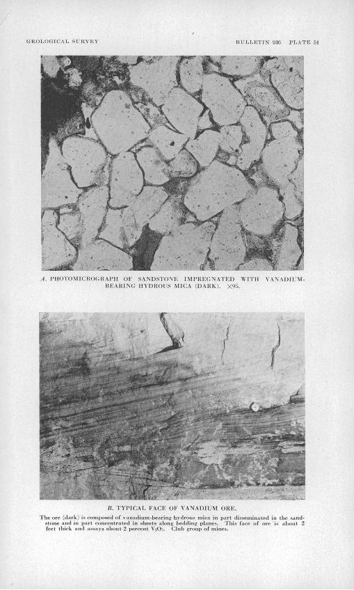
GEOLOGICAL SURVEY BULLETIN' 9.36 PLATE 54
A. PHOTOMICKOCRM'll OK SANDSTONK I M I'K K(J N A I Kl) WITH \ \\ADIUM- BEAKING HYDROUS MICA (DARK). Xy.r>.
B. TYPICAL FACE OF VANAUIIM OKE.
The ore (dark) in composed of vanadium-bearing hydrous mica in part diseetninated in the sand stone and in parl concentrated in sheets along bedding planes. This fa<-e of ore is about 2 feel thick and assays about 2 percent VjOj. Club group of mines.

GEOLOGICAL SURVEY BULLETIN 936 I'LATE 55
riie ore (dark) culn across the bedding, forming a roll, in barren sandstone (light). Note the slumping of the bedding planes across ibe central part of this zone, and the development of a fracture along the plane of greatest disturbance as a result of the removal in solution of the grains of quartz sand. Club group of mines.
It. THIN ZONE OF RICH VANADIUM ORE iDMiKi \I.O\C CONTACT OF ORE BODY (TO RIGHT) AND BARREN SANDSTONE (UI'I'EK LEFT).
Club group of mines.

GEOLOGICAL SURVEY 936 PLATE 56
I
A. I'AKALLEL ZONES. RESEMBLING DIFFUSION BANDS, OF RICH VANADIUM OKE (DARK) ALONG THE EDGE OF AN OKK BODY.
Saucer Bimin mine.
B. LENS OF SHALE-l'KBBLi; COMM.OM KKATK, I,N PART M1NEUALI/ED (DARK) AND IN PART BARREN (LIGHT).
The boundary of the ore, in the middle of the picture, cuts sharply across the shale-pebble lens.Little Uick mine.

VANADIUM DEPOSITS OF COLORADO AND UTAH 383
defined, and mineralized sandstone too thin or too lean to be
profitably mined extends considerably beyond the limit of mina-
ble ore. The ore bodies are so irregular in form that they can
not readily be classified. They consist of well-defined and
poorly defined masses, both of which may be present in a single
ore body.
The bodies with well-defined limits vary greatly in lateral
dimension but are thin; usually the thickness of the ore is only
a few feet, but in places it is as much as 15 feet. Although
irregular in detail, bodies of this type are essentially lens-
shaped many tend to be somewhat convex upward (see fige 46),
The ore is of good grade; much of it contains over 1^ percent
VgOgo One of the peculiar characteristic features of these
bodies is the tendency for the better-grade ore to lie along
the margins of the bodies.
Where the boundary of the ore is especially sharp, vanadium
minerals have been concentrated in a thin zone along the contact
of ore and barren rock, forming what the miners call a roll
(see pp. 379-380). Actually, the term roll as used by the
miners often applies to the body of good ore that is adjacent
to or partly enclosed within this curved surface. Two general
types of rolls have been noted along the sides of the ore
bodies: one is a roll convex outward from the ore body, and
the other is convex toward the ore body, with thin tongues of
ore extending along favorable bedding planes beyond the limit
of the commercial ore (see fig. 46). One type of roll may merge
laterally into a roll of the other type, the form of the roll
apparently being controlled by the lithologic character of the
sandstone rather than by some pre-ore structure imposed on the
sandstone. Rolls also form wavy surfaces on the tops and bot
toms of the ore bodies and seem to be more common and better
developed on the top than on the bottom. Along the rolls, where
mineralization was strong, some quartz has been dissolved (see

384 STRATEGIC MINERALS INVESTIGATIONS, 1942
pp. 379 and 380), and the resulting concentration of the vana
dium-bearing hydrous mica makes a plane of weakness to which the
rock breaks in mining. At most places where rolls lie along the
edges of the ore bodies, mineralization of the sandstone extend
ed only an inch or two beyond the surface of the rolls.
Hany of the rolls are small and irregular, but some of the
larger and better developed ones are elongate, and some extend
continuously for 50 or 60 feet. The conspicuously elongate
rolls are oriented in a common direction in many ore bodies.
Figure U6. Cross section of on ideal ore body with well-defined limits, showing (1) lens shape, tending to be somewhat convex upward, (2) ten dency for the better grade of ore to lie along the margins of the body, and (3) undulant rolls on the top and curved rolls on the sides of the body (on the left side of the sketch the roll is convex outward from the ore body, and on the right side the roll is convex toward, the body with thin tongues of ore extending beyond the limit of minable ore).
This direction seems to coincide with the trend or elongation of
those ore bodies, and any adjacent ore bodies are likely to lie
along this trend. The orientation of the rolls may thus be a
useful guide in prospecting. \
The bodies with poorly defined limits are mostly large and
thick bodies of low-grade ore (1 to Ij percent VgOg) in rela
tively massive, clean sandstone. The ore decreases in grade
laterally and vertically, and weakly mineralized sandstone may
extend considerably beyond the limits of commercial ore. Rolls
are not common in bodies of this type. Examples of such.ore
bodies are found at several places in Dry Valley, Utah, in the

VANADIUM DEPOSITS OP COLORADO AND UTAH 385
Ophir mine and in the Jo Dandy mine, Montrose County, Colo., and
in the Bear Creek mine of the Placervllle district, Colo.icy'- It has been reported by Coffin, and it is the opinion of
some miners, that joints related to regional structures may\
locally either cause an abrupt change in the thickness in the
ore or may border the ore, as if these joints controlled the
lateral movement of the ore-depositing solutions. But during >
many months of detailed study of these ores no joint related to
] regional structures was seen that definitely controlled the
thickness or distribution of the ore. In places, the inter
section of a roll surface and joint plane with a mine wall gives,
on casual observation, the false impression of such control.
In other places, postmineral faults, which have a horizontal
displacement of a few feet but a vertical displacement of only
a few inches, cause the ore to appear to end or abruptly change
i in thickness at the fault plane. All joints related to regional
/ structures are believed to have been formed later than the early
ore minerals.
Uravan district. Figure 47 is a simplified geologic map of
the Uravan district, Colo., showing the plan of the ore bodies
that have been mapped by the Geological Survey, the location of
the vanadium-bearing prospects and outcrops, and the outcrop of\
the base of the principal ore-bearing sandstone. The ore bodies
in the Long Park area, in the southern part of the district, are
alined in a northwesterly direction. Rolls and trends are not
well developed in the individual ore bodies, but the majority of
/ those that have been noted have northwesterly directions. Mos.t
of the rolls in the Saucer Basin mine (near the west end of the
cross section) have an easterly trend. No trends have been ob
served in the ore bodies of the Dolores group of mines, in the
northwest corner of the district.
.10/ Coffin, R. C., Radium, uranium, and vanadium deposits of south western' Colorado: Colorado Qeol. Survey Bull. l6, p. 162, 1921.

386 STRATEGIC MINERALS INVESTIGATIONS, 1942
The ore bodies of the Club group of mines, about a mile
southwest of Uravan, form one of the largest known groups in
Morrlson formation showing base of
Vanadium ore bodies(Dots show possib/e
extension of ore bod/es)
XVanadium-bearing outcrop
or prospect
Fault
ME.
2 Miles
Figure U7. Geologic map of the Uravan area, Montrose County, Colorado.
the region, and they have yielded more than 150,000 tons of
ore. It is estimated that this ore contained about 7,000,000
pounds of Vo05 , but only a small part of the vanadium contained

Dia
mo
nd
- dri/l h
ole
(p
roje
cte
d)
Dia
mo
nd
-dri
ll h
ole
(p
roje
cte
d)
td
d
VANADIUM DEPOSITS "OP COLORADO- AND UTAH 387
in the ore mined during the period 1911-1923 was recovered.
Plate 57 shows in detail the ore bodies and the mine workings
of this group. The limit of the vanadium-bearing sandstone,
shown by the heavy line on plate 57, was determined by direct
observations underground and by many drill holes not shown on
the map.
The ore bodies of the Club group mostly belong to the type
having well-defined limits, although some of the ore is massive
and of low grade and has poorly defined limits. The group of
ore bodies as a whole is alined in a northeasterly direction,
but individual elongate bodies and the conspicuous lobes of the
bodies of irregular outline are oriented about N. 70° E. This
trend is even more clearly shown by the orientation of the
larger and better developed rolls within the ore bodies (see pi.
57). The area most favorable for prospecting lies southwest of
the mines. Here, however, the ore-bearing sandstone is rather
deeply buried and for that reason has not been much prospected.
Many of the logs or trees that were buried in the sandstone
and have been exposed in the mine workings are also oriented in
an easterly or northeasterly direction (pi. 57). In most mines,
however, the logs do not have a common orientation and hence
are not considered to be reliable indicators of ore trends.
Origin and control of ore
The origin of the ore and the factors that controlled its
localization cannot yet be satisfactorily explained. The ore
minerals impregnate sandstone and in their present form were
deposited from.solutions after the sands were deposited, but
the nature of the solutions is not understood, nor is the im
mediate source of the metals apparent. ,
All joints related to regional structures are believed to
have formed later than the early ore minerals (see p. 385).
There are only four known localities in the region where ore

388 STRATEGIC MINERALS INVESTIGATIONS, 1942
minerals, other than the obviously secondary minerals, appear
to be localized by faults. At Temple Mountain, Emery County,!!/
Utah, according to Hess, vanadium and uranium minerals were
dissolved from ore bodies in the Shinarump conglomerate and were
deposited in small quantities along fractures in the overlying
Chinle formation and "lowest Jurassic sandstone" (Wingate).
Along a disturbed and faulted zone at Richardson, Grand County,
Utah, vanadium and uranium minerals have been sparsely deposited12/ 13/
in sandstone considered to be Wingate. Coffin reports
carnotite stains in Carboniferous and Dolores (Triassic) beds in
faulted areas in Gypsum Valley, San Miguel County, Colo. (The
unit mapped as Dolores by Coffin also includes beds now recog
nized as Wingate sandstone and Kayenta formation in addition to
the Dolores formation.) Along Roc Creek, in Montrose County,
Colo., small quantities of vanadium and uranium minerals occur
in Wingate sandstone near a down-faulted block of ore-bearing
Morrison. All other faults cut and displace the ore and appear
to be later than the ore. Furthermore, when the region is view
ed as a whole, the spacial distribution of the ore bodies fails
to suggest any genetic relationship to faults or folds,, The
only practical importance of faulting and folding consists in
their having affected the position of the productive beds.
In most areas the ore is largely or wholly confined to sand
stone of a certain stratigraphic zone. Some favorable con
ditions must have existed in this zone to localize the ore, but
these conditions have not been recognized. Sandstones similar
or identical in-appearance to the sandstone of the favorable
stratigraphic zone lie below or above this zone, but contain
little or no ore. Within the favorable atratigraph.ic zones,
however, the ore bodies, are not confined to a single cardstone
ll/ Hees, P. L., Uranium-tearing asphaltite sediments of Utah; Eng. and Win. Jour.-Press, vol. llU, p. 27U, 1922.
12/ Dame, C. H. , Geology of the Salt Valley anticline and adjacent areas. Grand County, Utah: U. S. Geol. Survey Bull. 863, pi. 1, 1935.
li/ Coffin, H. C., op. clt., p. 153.

VANADIUM DEPOSITS OF COLORADO AND UTAH 389
bed or to a single lithologic type of sandstone. Shale pebbles,,
clay films along bedding planes, and fossil plants commonly
localize high concentrations of the metals within ore bodies,
but aince these lithologic features are as abundantly present in
the adjacent barren sandstone as in the ore, they cannot have
controlled the position of the ore bodies. No evidence has been
found of echanical deposition and concentration of vanadlum-
and uranium-rich material that might have accumulated as the
sands were deposited and might, therefore, have served as the
immediate source of these metals.
The primary ore minerals are thought to have been introduced
into their present position not long after the sands were de
posited. If this is true, the metals were' probably transported
and deposited by ground waters, and the ores were probably
localized by delicate chemical and physical conditions that now
cannot be definitely recognized. This hypothesis probably re
quires at least three separate periods of ore deposition, to
account for the ore in the Shinarump, Entrada, and Morrison
formations.
SUGGESTIONS FOR PROSPECTING
As long as the origin of these deposits remains undetermined,
the localization of the ores cannot be satisfactorily explained,
but certain observed facts regarding their localization may be
useful as guides in prospecting.
Stratigraphic zones locally favorable for ore should be
recognized and prospecting and development restricted to them.
In the Placerville district the ore-bearing Entrada sandstone
is immediately overlain by the Pony Express limestone member of14/
the Wanakah formation, which makes an easily recognized strati-
graphic marker. At the Rifle deposit the top of the underlying
red beds similarly serves as a stratigraphic plane of reference.
lUy The Pony Express limestone metnber has been called the LaPlata lime stone In the San Juan Mountain region.

390 STRATEGIC MINERALS INVESTIGATIONS, 1942
In the Morrison formation, on the other hand, there is no defi
nite bed or plane that can be used as a stratigraphic guide.
The ore-bearing sandstone is underlain by red shale, which is
altered to gray or greenish-gray in the upper few feet the blue
clay of the miners and drillers (p. 376). It Is a common prac
tice to bottom drill holes In the red shale immediately below
the blue clay. Not all holes should be abandoned immediately
on reaching red shale, however, for in places a lens of red
shale, altered to gray or greenish gray in the upper few feet,
Is interbedded with or lies within the ore-bearing sandstone
(see cross section, pi. 57). Since many vanadium ore bodies lie
in the lower part of the ore-bearing sandstone, it is desirable
to drill through this sandstone. Where holes are drilled near
canyon walls, subsurface stratigraphic conditions can be In
terpreted from exposures along the cliffs. Where drilling is
undertaken some distance from canyon walls several holes in a
group should be continued to a considerable depth in order to
explore subsurface conditions and definitely establish the base
of the ore-bearing sandstone.
Many ore bodies are elongate, and in places the trend of
this elongation is indicated by the orientation of rolls in the
ore. The mapping of ore bodies and rolls shows this trend, thus
pointing to the areas most favorable for additional prospecting
and aiding in planning development. In one mine studied, the
mine workings first opened were elongated in a northeasterly
direction, but the orientation of the rolls suggested a north
westerly trend. Subsequent arilIin5, encircling those mine
workings, disclosed, previously lansiispoc-bed. extensions of tKe or-e
body to the northwest and southeast. The trend indicated by
the elongation of an ore body, or by the rolls within an ore
body, may also Indicate the general alinement of any nearby ore
bodies.

VANADIUM DEPOSITS OP COLORADO AND UTAH 391
Where rolls lie along th'e sides of ore bodies the sandstone
tends to break to the curved surface of the roll, leaving what
looks like a face of high-grade ore. As the ore minerals pene
trate the sandstone only an inch or two beyond this surface,
however, channel samples cut from mine walls at such places have
no practical use and give an entirely false concept of the value
of this face. Diamond drilling from the surface has so far
proved to be the most satisfactory method of subsurface pros
pecting where the sandstone favorable for ore is not too deeply
buried. With the light drill rigs commonly used in the Colorado-
Utah region, it is rarely feasible to drill deeper than about
125 feet, but these rigs have the advantage of being easily
moved and set up. A common practice is to encircle an ore body
with drill holes when underground workings cease to develop new
ore. The trend indicated by rolls or a pronounced elongation of
the ore body should aid in determining the most favorable places
to drill, but not all drilling should be restricted to the in
dicated trends, for some ore bodies, such as those in the Club
group of mines (pi. 57), are alined in an en echelon pattern,
and in places elongate bodies have been found lying side by side
rather than end to end.
Because of the extreme spottiness of ore bodies and the
large ratio of barren to mineralized ground (fig. 47), wildcat
drilling, at some distance from known ore bodies, should be
largely restricted to established alinements. Wildcat drilling
across the recognized alinement in Long Park, Montrose County,
Colo., has disclosed several ore bodies more than a thousand
feet from ground previously known to be mineralized.
Subsurface prospecting by underground drifting is useful in
places, especially where diamond drilling is not feasible because
of excessive depth to the ore-bearing sandstone. It is in
advisable to drift blindly through barren sandstone, but it is
good practice to follow thin tongues of vanadium-bearing

392 STRATEGIC MINERALS INVESTIGATIONS, 1942
sandstone that extend laterally beyond the limits of commercial
ore drifts following these tongues have led to new ore bodies.
As the sandstone is not hard, such drifting is not very costly,
and it may, too, be partly paid for by the vanadium-bearing
sandstone broken in the drift, for the mineralized tongues,
though too thin to be mined for their own sake, contain in places
as much as 3 or 4 percent VgOco This manner of prospecting is
especially applicable in the Placerville district, where steep
valley walls and thick overburden make diamond drilling im
practicable.
Of the several methods of geophysical prospecting that have
"been tried, the detection of radioactivity "by the Geiger-Muller
counter appears to be the most effective. This method detects
only the radioactive disintegration products of uranium, but as
significant quantities of uranium are everywhere associated with
the vanadium ores in the Morrison formation and the Shinarump
conglomerate, the method should be applicable in diamond drilling15/
and underground prospecting. Kelly found that apparently
barren sandstone, cored from a horizon as much as 20 feet above
ore, gave distinct gamma-ray evidence of radioactivity. It is
believed that a similar effect should be obtained from sandstone
a short distance laterally from ore bodies. As the rock sur
rounding ore is not visibly altered and contains no distinctive
minerals, drill holes that penetrate barren sandstone within a
short distance of ore show no visible evidence that ore is near.
This sandstone, however, may well be somewhat radioactive, and
with the aid of the Geiger-Muller counter it might ,be possible
to find evidence of the proximity of ore in holes as much as 15
or 20 feet from an ore body. Further systematic studies are
needed to establish' and evaluate the possibilities offered hy
this technique.
15/ Kelly, S. F., Geological studies of vanadium-uranium deposits "by geo- sical exploration methods: Win. Cong. Jour. , vol. 27, pp. 27-35, 19^»
VANADIUM DEPOSITS OP COLORADO AND UTAH 393
The Geiger-Muller counter appears to have similar application
underground in indicating bodies or pockets of ore that lie16/
near mine workings but have been overlooked during mining.
Electrical, magnetic, and electrical-resistivity methods of
geophysical prospecting cannot be successfully applied directly
to the ore itself, but an indirect application of the electricalIT/
resistivity method is reported to have met with some success.
Where the ore-bearing sandstone is not too deep, this method can
be applied to determine the thickness of the sandstone and to
delimit areas in which the sandstone, being unsually thick, is
presumably more favorable for ore»
MINING AND MILLING
Prospecting
Two general methods of prospecting are now employed: (1)
The most common practice is to follow the outcrop of the ore-
bearing sandstone, looking for showings of ore on the cliff face,
and for float of ore on the slopes below. (2) Diamond drilling
is confined mostly to areas indicated as favorable on the basis
of past production or by established ore trends. Where depth\
to the ore-bearing sandstone is not excessive the usual limit\
being about 125 feet mines approaching exhaustion are encircled
by drill holes, the spacing of the holes being controlled by
local conditions. In wildcat drilling, at some distance from
known ore bodies but along established alinements, it is common
practice to drill holes 100 feet apart on a line across the
trend. Where ore is encountered, holes are drilled at closer
intervals, but no attempt is made to block out more ore than is
necessary to justify the estimated cost of opening the body for
mining.
l6/ Kelly, S. f., op. cit., p. 35. \]J Idem, pp. 27-35-

394 STRATEGIC MINERALS INVESTIGATIONS, 1942
Mining
Mining methods differ with the size of the mine. In small
mines, where no more than three or four men are employed, the
common practice is merely to follow the ore in mining. Drilling
is done by hand or with a jackhammer driven by a small, portable
compressor. Average production ranges from ^ to 1 ton of ore
per man-shift. In larger mines more systematic mining methods
are used. The general practice is to drive one or more drifts
through the ore, possibly to the commercial limits of the body,
and to mine from these by irregularly spaced side drifts, leav
ing pillars of low-grade ore and barren rock. Vertical stulls
are used in places. Ore pillars are robbed and the ground al
lowed to cave on final retreat from the mine. Tramming is done
by hand, but electric, compressed air, or gasoline-driven hoists
are used for raising the ore up inclines. Air compressors are
driven by gasoline or Diesel engines. Production ranges from 1
to 2 tons of ore per man-shift. In order to avoid too much hand
sorting an effort is made to shoot ore and waste rock separately.
Milling
Ore is trucked to the mills from many widely scattered oper
ations. At the mill the ore is crushed, mixed with common salt,
and roasted, converting the vanadium minerals into a soluble
sodium vanadate, which is then leached by water. Acid is added
to the solution, preclpltatin5 tne sodium vanadate. The pre
cipitate may be sacked and atiipp©a in tKia form, but at most
mills it is fused before shipment.
O


![Solutions for Mathematica Exercises ( P. Fischer)Solutions for Mathematica Exercises (© P. Fischer) Exercise 1: Numbers Sqrt[2] (* By default, Mathematica stays with exact expressions](https://static.fdocuments.in/doc/165x107/5e80c7888c54e20bde2076b2/solutions-for-mathematica-exercises-p-fischer-solutions-for-mathematica-exercises.jpg)