BY ORDER OF THE COMMANDER 35TH FIGHTER WING...
32
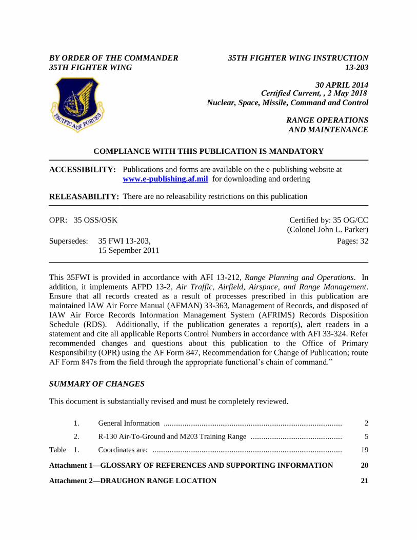
BY ORDER OF THE COMMANDER 35TH FIGHTER WING 35TH FIGHTER WING INSTRUCTION 13-203 30 APRIL 2014 Nuclear, Space, Missile, Command and Control RANGE OPERATIONS AND MAINTENANCE COMPLIANCE WITH THIS PUBLICATION IS MANDATORY ACCESSIBILITY: Publications and forms are available on the e-publishing website at www.e-publishing.af.mil for downloading and ordering RELEASABILITY: There are no releasability restrictions on this publication OPR: 35 OSS/OSK Supersedes: 35 FWI 13-203, 15 Sepember 2011 Certified by: 35 OG/CC (Colonel John L. Parker) Pages: 32 This 35FWI is provided in accordance with AFI 13-212, Range Planning and Operations. In addition, it implements AFPD 13-2, Air Traffic, Airfield, Airspace, and Range Management. Ensure that all records created as a result of processes prescribed in this publication are maintained IAW Air Force Manual (AFMAN) 33-363, Management of Records, and disposed of IAW Air Force Records Information Management System (AFRIMS) Records Disposition Schedule (RDS). Additionally, if the publication generates a report(s), alert readers in a statement and cite all applicable Reports Control Numbers in accordance with AFI 33-324. Refer recommended changes and questions about this publication to the Office of Primary Responsibility (OPR) using the AF Form 847, Recommendation for Change of Publication; route AF Form 847s from the field through the appropriate functional’s chain of command.” SUMMARY OF CHANGES This document is substantially revised and must be completely reviewed. 1. General Information ............................................................................................... 2 2. R-130 Air-To-Ground and M203 Training Range ................................................. 5 Table 1. Coordinates are: ..................................................................................................... 19 Attachment 1—GLOSSARY OF REFERENCES AND SUPPORTING INFORMATION 20 Attachment 2—DRAUGHON RANGE LOCATION 21 Certified Current, , 2 May 2018
-
Upload
duongnguyet -
Category
Documents
-
view
220 -
download
1
Transcript of BY ORDER OF THE COMMANDER 35TH FIGHTER WING...
BY ORDER OF THE COMMANDER
35TH FIGHTER WING
35TH FIGHTER WING INSTRUCTION
13-203
30 APRIL 2014
Nuclear, Space, Missile, Command and Control
RANGE OPERATIONS
AND MAINTENANCE
COMPLIANCE WITH THIS PUBLICATION IS MANDATORY
ACCESSIBILITY: Publications and forms are available on the e-publishing website at
www.e-publishing.af.mil for downloading and ordering
RELEASABILITY: There are no releasability restrictions on this publication
OPR: 35 OSS/OSK
Supersedes: 35 FWI 13-203,
15 Sepember 2011
Certified by: 35 OG/CC
(Colonel John L. Parker)
Pages: 32
This 35FWI is provided in accordance with AFI 13-212, Range Planning and Operations. In
addition, it implements AFPD 13-2, Air Traffic, Airfield, Airspace, and Range Management.
Ensure that all records created as a result of processes prescribed in this publication are
maintained IAW Air Force Manual (AFMAN) 33-363, Management of Records, and disposed of
IAW Air Force Records Information Management System (AFRIMS) Records Disposition
Schedule (RDS). Additionally, if the publication generates a report(s), alert readers in a
statement and cite all applicable Reports Control Numbers in accordance with AFI 33-324. Refer
recommended changes and questions about this publication to the Office of Primary
Responsibility (OPR) using the AF Form 847, Recommendation for Change of Publication; route
AF Form 847s from the field through the appropriate functional’s chain of command.”
SUMMARY OF CHANGES
This document is substantially revised and must be completely reviewed.
1. General Information ............................................................................................... 2
2. R-130 Air-To-Ground and M203 Training Range ................................................. 5
Table 1. Coordinates are: ..................................................................................................... 19
Attachment 1—GLOSSARY OF REFERENCES AND SUPPORTING INFORMATION 20
Attachment 2—DRAUGHON RANGE LOCATION 21
Certified Current, , 2 May 2018
2 35FWI13-203 30 APRIL 2014
Attachment 3—DANGER AREAS / JETTISON / SALVO AREA 22
Attachment 4—CONFIGURATION/AUTHORIZED DELIVERIES 23
Attachment 5—MISAWA PCA AND NO-FLY AREAS 25
Attachment 6—PATTERNS HOLDING & HUNG ORDNANCE 26
Attachment 7—M203 TRAINING SITE 27
Attachment 8—DRAUGHON RANGE AIRCRAFT-MOUNTED SYSTEMS LASER
SURFACE DANGER ZONES 28
Attachment 9—PROPOSED PROCEDURES FOR SCRAPING CONVENTIONAL
TARGET 29
Attachment 10—RISK ASSESSMENT FOR DRAUGHON RANGE 31
1. General Information
1.1. Introduction: R-130 (Draughon Range) and associated airspace is a Class A, joint use
air-to-ground training range, located 10 NM north of Misawa Air Base. This supplement
contains information and directives applicable to Draughon Range. It describes user and
support responsibilities, scheduling procedures, boundaries, restrictions, and operating
procedures for the range.
1.2. Range Responsibilities:
1.2.1. Operational control of Draughon Range is exercised by 35 OG/CC and
implemented by 35th Operations Support Squadron (35 OSS) as the USAF Range
Operating Agency (ROA) for Draughon Range (R-130).
1.2.2. 35th Operations Support Squadron flight scheduling section (35 OSS/OSOS) is
responsible for scheduling range periods for United States Forces Japan (USFJ) and for
coordinating use by Japan Air Self Defense Force (JASDF).
1.2.3. Draughon Range Operations and Management (35 OSS/OSOR) is provided by
civilian contractor. The contractor is responsible for the accomplishment of range
operations, maintenance and complying with established agreements regarding Draughon
Range. Range Operations Officer (ROO)/Quality Assurance Evaluation (QAE) is
provided by 35 OSS Current Operations (35 OSS/OSO) with oversight from 35th
Operations Support Squadron Commander (35 OSS/CC).
1.2.4. 35 OSS/OSOR, in accordance with (IAW) AFI 91-207, The US Air Force Traffic
Safety Program, establishes a vehicle training program for range personnel required to
use any special purpose vehicles including all terrain vehicles (ATVs) and snowmobiles.
35th Fighter Wing Safety (35 FW/SE) reviews and approves this program as required.
1.2.5. 35th Civil Engineer Squadron Explosive Ordnance Disposal (EOD, 35 CES/CED)
is responsible for range decontamination, clearance, and munitions disposal.
1.2.6. Fire fighting capabilities and prevention:
35FWI13-203 30 APRIL 2014 3
1.2.6.1. Draughon Range has limited fire fighting capability.
1.2.6.2. Draughon Range Control Officer (RCO) will cease all operations, call the
Misawa fire department, and coordinate first responder personnel (including JASDF)
to contain/extinguish any unplanned or uncontrolled fires.
1.3. Target Area Maintenance, Decontamination, and Clearance:
1.3.1. Definition of Terms.
1.3.1.1. Target area maintenance. The term maintenance includes target construction,
repair, or replacement as well as target area decontamination, clearance, and
ammunition disposal. Decontamination and clearance are defined as follows:
1.3.1.1.1. Decontamination. The inspection, rendering safe, removal, and
destruction of dud/fired munitions from clearance zones specified in AFI 13-212.
1.3.1.1.2. Clearance. The policing of target debris and ordnance declared and/or
marked safe by EOD personnel with subsequent transport to a designated disposal
area.
1.3.2. Target Area Maintenance.
1.3.2.1. Draughon Range will be closed for conventional use, and emitters located on
the range property will not emanate, while decontamination and clearance operations
are being actively conducted. Range personnel will request Airfield Management (35
OSS/OSAM) transmit an appropriate notice to airmen (NOTAM) and local advisories
a minimum of 3 days prior to closures for decontamination/clearance operations. On
the day(s) of closure, range personnel will contact Radar Approach Control
(RAPCON) to issue over-fly restrictions as necessary. When the range is operational,
the RCO must approve any target or target area maintenance.
1.3.2.2. All range closures for maintenance or equipment outage will be coordinated
through 35 OSS/OSOS, Naval Air Facility (NAF) Misawa Liaison and 3rd AW
(JASDF).
1.3.3. Decontamination clearance plans will be scheduled and approved by 35 OSS/CC
in coordination with 35 OSS/OSOS, 13 FS, 14 FS, 3rd AW, NAF Liaison, and EOD. 35
OSS/OSOR will publish a decontamination clearance plan annually by 15 September for
the upcoming 12-month period. The following organizations will provide support
required to accommodate range decontamination clearance in an efficient and safe
manner. Each organization will be responsible for establishing procedures which will
assure proper and timely support for flying training operations. A complete and signed
decontamination plan will be forwarded to all coordinating and executing agencies.
1.3.3.1. 35 OSS/OSOR will:
1.3.3.1.1. Coordinate with 35 OSS/OSOS, NAF Liaison, 3rd AW, EOD, 35th
Medical Group (35 AMDS/SGPF), 35 FW/SE, 35th Fighter Wing Public Affairs
(35 FW/PA) and any other required agencies concerning the scheduled range
decontamination.
1.3.3.1.2. Oversee planning and scheduling of range decontamination clearance.
4 35FWI13-203 30 APRIL 2014
1.3.3.1.3. Coordinate with EOD for collection and disposal of range residue IAW
applicable directives.
1.3.3.1.4. Monitor range conditions to determine decontamination clearance
requirements and conditions requiring special attention.
1.3.3.2. 35 OSS/CC will:
1.3.3.2.1. Approve all decontamination clearance plans.
1.3.3.2.2. Advise 35th Operations Group Commander (35 OG/CC) and outside
units of specific operational range restrictions and dates through 35 OSS/OSOS.
1.3.3.3. 35th Maintenance Group Commander (35 MXG/CC) will:
1.3.3.3.1. Provide maintenance support in accordance with the terms and
conditions of the Operations and Maintenance of Draughon Range contract.
1.3.3.4. 35 CES/CED (EOD) will:
1.3.3.4.1. Provide qualified personnel to clear explosive hazards and inspect and
dispose of all ordnance found on Draughon Range.
1.3.3.4.2. Provide safety briefings for RCOs, range personnel, visitors, and all
personnel involved in decontamination clearance operations as required.
1.3.3.4.3. Provide a copy of decontamination clearance report to include total
tons removed, total acres cleared, number/hours of EOD personnel used,
number/hours of non-EOD personnel used, and munitions cleared (type, number
cleared, number of duds) to 35 OSS/OSOR as input for the Annual Range
Activity Report.
1.4. Weapons Range Supervision: Operational control of Draughon Range is exercised by
35 OG/CC. The contractor’s support of normal and exercise operations is performed under
the operational direction of 35 OSS/CC. The ROO/QAE is responsible for evaluating and
reporting contractor performance. The Contracting Officer (CO) ensures the contract is
administered in accordance with applicable regulations and issues any modifications to the
contract while the Contracting Administrator (CA) oversees the ROO/QAE surveillance
effort. Range Manager duties include, but are not limited to:
1.4.1. The authority to contractually and financially obligate the contractor’s company,
and to make and implement all decisions regarding the performance of the range contract.
1.4.2. Coordinate range flying operations, procedures, and management with ROO/QAE,
Mission Support Group agencies, and all users IAW this instruction.
1.5. Photographic Support: 35 FW/PA will provide photographic support for all 35 FW
range operations as required. Duties include processing and developing range photos. PA
will also provide necessary notifications to the public when applicable.
1.6. Weather Support: 35 OSS Weather Flight (OSW) provides weather forecasting
support. Draughon Range personnel will be trained to provide limited observation reports to
the Weather Flight.
35FWI13-203 30 APRIL 2014 5
1.7. Range Access/Inspections:
1.7.1. Unescorted/Escorted:
1.7.1.1. All personnel within Draughon Range area will have 2-way communication
radios at all times.
1.7.1.2. Escorted personnel are required to be briefed on range safety/security and
must be accompanied by range personnel. Escorted personnel will not enter the
20MM HEI target at any time unless directly briefed/escorted by a qualified EOD
technician.
1.7.1.3. Unescorted personnel are required to be briefed on range safety/security by
range personnel and must receive an EOD briefing annually. 35 OSS/OSOR will
keep records of all unescorted personnel EOD briefing dates. Unescorted personnel
will not enter the 20MM HEI target at any time unless directly escorted by a qualified
EOD technician.
1.7.2. Inspections: All Misawa Air Base agencies having a need to inspect Draughon
Range will notify the QAE no later than 72 hours prior to the proposed visit. This is to
avoid conflicting visits and to ensure an escort is available. Confidentiality of no-notice
“trusted agent” visits will be respected.
1.7.3. Range Access: Visitor access to Draughon Range will be limited to official
business only. All personnel are required to notify 35 OSS/OSOS prior to being granted
access. Visits will be coordinated through the QAE (226-3841) at least 72 hours prior to
visit. All military and civilian personnel will be properly identified before access is
granted. Visitors must be escorted/supervised by range personnel at all times.
1.7.3.1. Range visitation and access by any persons who are neither US military/civilian
personnel nor Japanese military/civilian personnel require GoJ notification in advance of
entry. Notification should be made via 35 OSS/OSOS and QAE NLT 30 days in
advance. As an absolute minimum in unforeseen circumstances, a 10-day prior
notification of GoJ is required.
2. R-130 Air-To-Ground and M203 Training Range
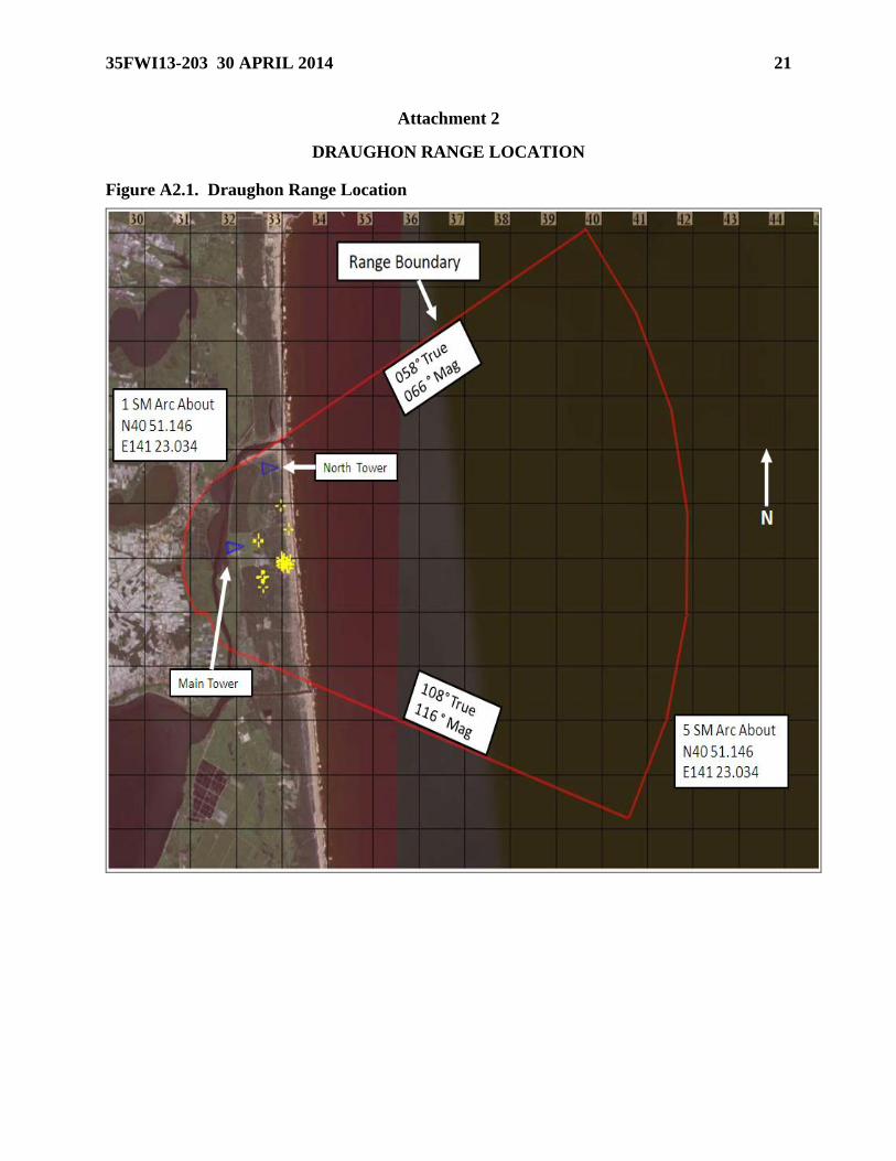
2.1. General: R-130 (Draughon Range) and associated airspace is a Class A, joint use air-
to-ground training range, located 10 NM north of Misawa Air Base. The land area is
approximately 1900 acre semi-circle, one statute mile in radius, from a focal point at
N4051.146/E14123.034 (WGS-84). The entire eastern edge of Draughon Range borders the
Pacific Ocean. The northern sea area boundary is a line drawn 058 degrees true from the
northern tip of the land area. The southern sea area boundary is a line drawn 108 degrees
true from the southern tip of the land area. Draughon extends to the east by a 5 statute mile
arc from the focal point (See Attachment 1).
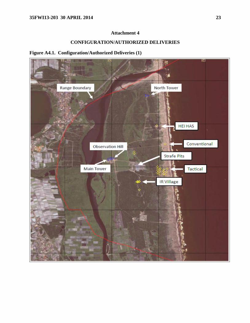
2.2. Range Configuration (See Attachment 3.1): Range configuration is updated as
required for local training use. Updates to the current range configuration, locations, and
Weapons Danger Zone (WDZ) data can be obtained through 35 OSS/OSK (DSN 226-3187).
2.2.1. Range Towers: North flank tower (N4052.887/E14123.330), located NE of main
tower, will not be manned by contractor personnel when winds are 30 knots steady state
6 35FWI13-203 30 APRIL 2014
or gusting at 35 knots or greater. Also, manual scores cannot be given under this
condition. The main control tower (N4052.083/E14122.745) is rated at 66 knots.
2.2.2. Conventional Target: Consists of a bulls eye with concentric circles at 75 feet
(22.86 meters) and 150 feet (45.72 meters) centered on the target (normally a shipping
container, sea box, or conex van). It is located 4,030 feet (1228.34 meters) east/northeast
of the main tower. Target coordinates are N 4052.271 E 14123.596 (WGS-84), elevation
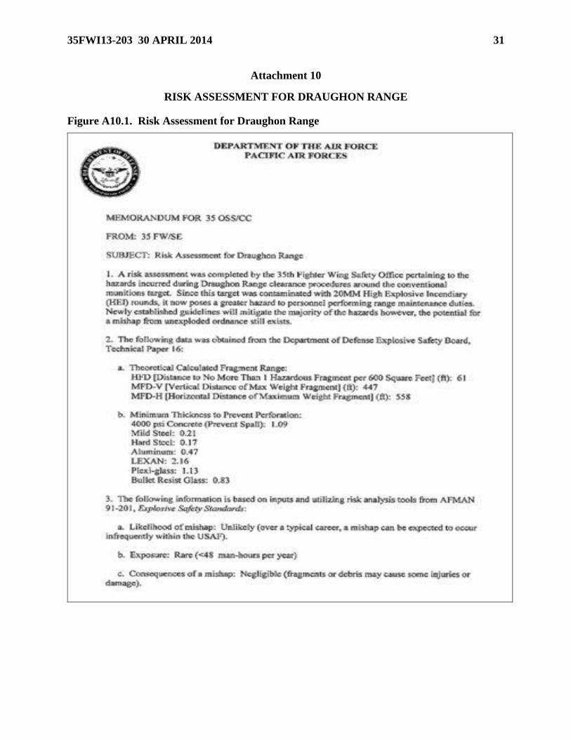
is approximately 16 feet. Due to accidental 20MM HEI firing on this target, it is a danger
zone requiring additional safety measures by EOD. Reference Attachment 8, Proposed
Procedures for Scraping Conventional Target, dated 28 June 2010, for more information.
Also reference Attachment 9, Risk Assessment for Draughon Range, dated 21 June 2010.
2.2.3. 20MM HEI UXO Target: Consists of two orange sea containers aligned next to
each other. The target is for High Angle Strafe with HEI ammunition only. Low angle
strafe is not authorized on this target. Target coordinates are N4052.504 & E14123.469.
Current target location prevents EOD from conducting decontamination procedures.
Unexploded 20MM HEI remain in the danger zone and ORM dictates only qualified
EOD technicians or personnel escorted by EOD enter the target area. Reference
Attachment 9, Risk Assessment for Draughon Range, dated 21 June 2010, for more
information.
2.2.4. JASDF (Rocket) Target: Located northeast of the conventional target. US forces
are not authorized to employ any type of munitions on the JASDF target.
2.2.5. Low/High Angle Strafe (LAS/HAS) Targets: Panels 1 and 2 are designated for
low angle strafe. Panel 4 is designated for high angle strafe only. Panel 3 is not used.
All strafe panels have a 2,000' foul line, identified by a line of orange barrels abeam the
main tower. Strafe panels will not be available when steady state winds are greater than
20 knots or gusting greater than 25 knots.
2.2.6. Tactical Targets: Trucks, conex vans, simulated anti-aircraft guns, tracking
devices, and aircraft comprise the tactical target area east of the strafe targets. Contact 35
OSS/OSK for current range configuration and coordinates.
2.2.6.1. High angle strafe is permitted on the center tactical targets, but electronic
scoring is not available. RCOs will give general information based on visual impact.
The puppy paws will not be targeted for strafe.
2.2.6.2. LAS is permitted on the tactical target array only from dry passes under
flight lead control. Soil surrounding the tactical target array is not maintained
appropriately for any hot LAS; ricochets from hot passes on the tactical target array
could impact the delivering aircraft. This restriction does not apply to helicopter gun
employment; helicopters may employ hot gun passes from low angle on the tactical
target array in accordance with restrictions in Para. 2.8.3.2.
2.2.7. Electronic Combat Range Equipment. A RWR light emitter is also located in the
mobile van.
2.2.7.1. RWR Light: The RWR light is a 9 GHz emitter.
35FWI13-203 30 APRIL 2014 7
2.3. Range Restrictions (see Attachment 2 and Attachment 4): Pilots will use the most
restrictive range procedures, weather minimums, and emergency procedures found in flight
regulations and range regulations for the aircraft employing on Draughon Range.
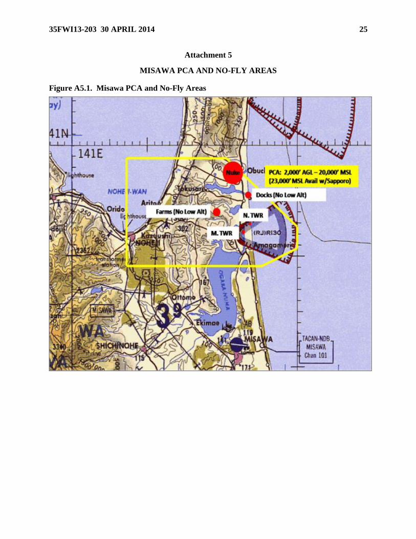
2.3.1. Airspace: Draughon Range is located within the Misawa Positive Control Area
(PCA) (2,000’AGL to FL230, bounded by coordinates N4059.17, E14107.28; N4059.17,
E14120.78; N4053.17, E14129.78, N4051.08, E14130.00; N4049.17, E14124.78;
N4049.17, E14107.28; to beginning. See Attachment 4). Misawa Approach Control or
Sapporo Area Control Center must clear flights into the PCA. R-130 (with Misawa PCA)
is available from the surface to 20,000 feet MSL during scheduled range periods.
Airspace to 23,000 feet is available on request through Sapporo Area Control Center
(UHF 279.2/VHF 119.3); pilots must request the airspace to 23,000 from Sapporo Area
Control Center.
2.3.1.1. Aircraft must be cleared into the Draughon PCA through RAPCON. Aircraft
must be cleared into Draughon Range airspace (R-130) by the RCO.
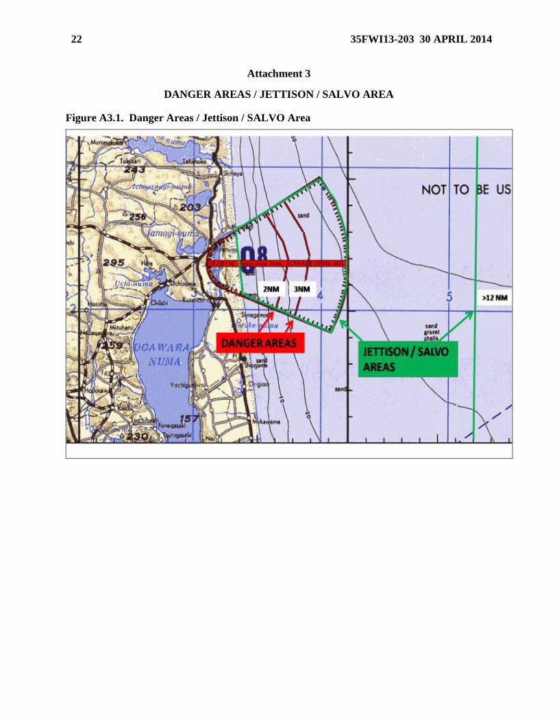
2.3.2. Danger Areas (See Attachment 2): Danger areas extend from the northern sea
boundary to the southern sea boundary in a 2-mile arc for training rounds (e.g. BDU-33)
and a 3-mile arc for inert heavy-weight ordnance. Boats and other watercraft are advised
to avoid these areas when Draughon is “Hot.” Pilots will not drop ordnance on Draughon
when boats or other watercraft are within the described danger area arcs, however, dry
passes are authorized.
2.3.3. No-Fly Areas (See Attachment 4): Over flight of the Draughon Range main tower
(N4052.42/E14123.39), north flank tower (N4052.43/E14123.33), and the Rokkasho
nuclear power plant north of Draughon Range (N4058.5/E14121.0) is prohibited. The
blue-roofed farms to the west of Draughon Range (N4054.08/E14119.03) and the piers to
the northeast of the target (N4055.56/E14123.76) may not be overflown at low altitude.
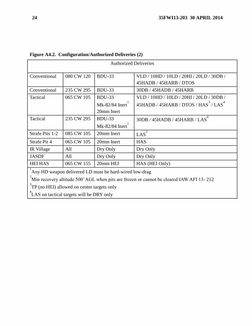
2.3.4. Deliveries: All Deliveries will be IAW Attachment 3.2. Loft and toss deliveries
are limited to +10 degrees nose high when “Hot” on Draughon Range. Weapons should
be armed “Hot” over water when possible. All ordnance must be released to impact
within the range boundary. First run attacks are authorized given the flight has
previously coordinated with the RCO, is in radio contact with the RCO, and no boats or
watercraft are in the danger area. Dry passes and simulated attacks may be accomplished
from any attack axis provided they do not overfly the no-fly areas.
2.3.5. Weather:
2.3.5.1. Day Conventional: Ceiling must be 500 feet above the highest portion of the
bombing pattern and 3nm of visibility with a discernable horizon. Ordnance will not
be dropped or fired through overcast conditions. For dry loft/toss deliveries, pull-up
through overcast conditions is prohibited. Local Misawa altimeter will be used unless
updated by Draughon Tower. Helicopter minimums will be IAW weapons system
and applicable instructions.
2.3.6. Ordnance And Pyrotechnics Authorized: Authorized ordnance and pyrotechnics
include 20mm//5.56mm/7.62mm/50 cal target practice and tracer rounds, rockets
equipped with inert warheads or spotting charge, and inert free-fall (i.e. non PGM) bombs
not to exceed 2,000 pounds. Chaff and flares are prohibited within the R130 airspace.
8 35FWI13-203 30 APRIL 2014
Expenditure of heavyweight inert ordnance (MK-82 to MK-84 class ordnance) is only
authorized on the tactical target array. Dry passes may be accomplished simulating any
munition as long as the munitions are mechanically safe, cannot be released from the
aircraft, and that the passes do not overfly no-fly areas. Authorized deliveries will be
IAW Attachment 3.2.
2.3.6.1. Any high-drag weapon delivered low-drag must be hard-wired low-drag.
2.3.7. Number of Aircraft: There will be a maximum of four aircraft in the day
conventional pattern. With RCO and flight lead coordination, additional aircraft may be
in the PCA and/or on Draughon Range and will be positively de-conflicted from each
additional flight.
2.4. Range Holding/Entry:
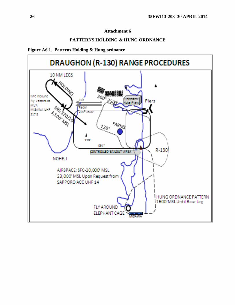
2.4.1. Holding (See Attachment 5): Visual Meteorological Conditions (VMC) holding is
on the MIS 320/20, left hand turns, 10nm legs at 3500’ (over Mutsu Bay north of
Noheji). If unable to hold VMC, contact Misawa RAPCON on UHF 317.8 for clearance
to hold in IMC with a block altitude.
2.4.2. Deconfliction: In order to de-conflict range entries and departures, entering flights
will remain at or below 3000' MSL until “feet dry” inbound (east shore of Mutsu Bay)
and westbound departing flights will exit above 4000' MSL. If flights departing the range
westbound are unable to climb above 4000' MSL under VMC, they will deconflict their
departure with flights holding for range entry on range frequency. Reference Area
Planning (AP/3) for complete information on Misawa PCA.
2.4.3. Entry: Clearance must be obtained from the RCO prior to entry onto Draughon
Range.
2.4.3.1. Minimum altitude for a spacer pass is 500' AGL. Range entry from the east
direct to downwind is permitted, provided no aircraft are on the range. A tactical
entry to a hot-delivery on either the conventional or tactical targets requires RCO
approval and must be performed under guidance in Para. 2.3.4., as applicable.
2.4.3.2. Helicopters are authorized to enter Draughon Range airspace from any
direction. Entry direction will be cleared with the RCO prior to entry to de-conflict
with scheduled fixed wing range periods. Helicopters will complete a clearing pass
along and over the range boundaries before live fire operations.
2.4.4. Exit: Prior to departing Draughon airspace, pilots must contact Misawa Approach.
Once identified by Misawa approach and recovering to Misawa, fly heading 100º (Rwy
28)/ 280º (Rwy 10) prior to switching to Misawa Tower. Use caution for numerous
aircraft operating in Misawa’s VFR and IFR traffic patterns; downwind for both of these
patterns is approximately 5 nautical miles south of the Draughon PCA. Aircraft exiting
Draughon Range but not recovering at Misawa should hold in Draughon airspace until
Misawa Approach has provided departure/clearance instructions and traffic advisories as
necessary.
2.5. Hours of Operation: Draughon Range normal operating hours are 0700 to 2000
Monday through Friday (local time). Weekend and U.S. Federal holiday use is by exception
35FWI13-203 30 APRIL 2014 9
only and requires 35 FW/CC and 35 CONS approval to ensure contractual obligations are not
violated.
2.5.1. Extended Hours: Extended hours to 2200 local time during the months of April–
September for a maximum of 15 days per month and a maximum total of 60 days over
the six month period, are available upon request from 35 OSS/OSOS and must be
requested a minimum of 20 days in advance. During extended hours, the range will be
open from either: 0800-2100, or 0900-2200. If the range is to be used between 2000 and
2200 local, 35 OSS/OSOS will notify 35 FW/PA, who will then notify the local Defense
Facilities Administration Office (DFAO), NLT 15 days in advance of intended use. As
an absolute minimum in unforeseen circumstances, a 5-day prior notification of DFAO is
required.
2.6. Scheduling:
2.6.1. Authority: 35 OSS/OSOS is the only scheduling authority for Draughon Range
usage. All ground or airborne use of Draughon Range for training requires at least 48
hours prior notice for approval unless further lead time is required per the guidance in
para. 2.5.1.
2.6.2. Requests: 35 FW squadrons should submit their biweekly Draughon Range
requests NLT the close of business on the Thursday preceding the upcoming range
deconfliction meeting outlined in para 2.6.3.
2.6.3. Deconfliction Meetings: De-confliction meetings occur weekly on Tuesday at
1300 and cover a two week scheduling period. 35 FW squadrons have priority for the
first week and JASDF has priority for the second week of each two-week period.
2.6.4. Naval Scheduling: Aircraft departing from aircraft carriers will submit range
airspace requests no later than 1200 the day prior to use. Navy and Marine requests for,
and changes to, the range schedule will be made through Naval Air Facility Flight
Support, then forwarded to 35 OSS/OSOS.
2.6.5. Cancellations: All cancellations must be made at least 24 hours prior to the
scheduled range time. Changes, additions, or deletions to the range schedule will be
forwarded to 35 OSS/OSOS, who will notify range personnel of all changes to the
schedule. USFJ will contact 35 OSS/OSOR directly if unable to notify 35 OSS/OSOS.
2.6.6. Range Cleanup: During scheduled range maintenance and EOD cleanup, adhere
to the restrictions below. Electronic warfare emitters on Draughon Range property will
not emit while EOD operations are actively being conducted.
2.6.6.1. Overflight Procedures: Overflight is not authorized without the concurrence
of the ground party and RCO/ROO approval over areas or portions of ranges during
maintenance and clearance operations. This ensures the protection of ground
personnel and prevents aircraft damage by fragments from explosives operations.
Strict adherence to the procedures outlined below is mandatory.
2.6.6.2. When range maintenance or clearance personnel are present on the range and
explosives operations are not planned, aircraft will remain at or above 3,000’ AGL
unless a lower altitude is specifically approved by the ground party and RCO/ROO.
10 35FWI13-203 30 APRIL 2014
2.6.6.3. When explosives operations are planned, aircraft will remain at or above
7,000’ AGL to ensure containment of H-6 fill Mk-84 fragmentation.
2.6.6.4. When no personnel are on the range but the range is closed for maintenance
or clearance operations, aircraft operations may proceed with no additional altitude
restrictions. Only simulated weapons deliveries are allowed IAW applicable
directives. Eye safe laser operations are authorized during range clearance closures.
All restrictions will be clearly identified in the range schedule.
2.6.7. Bootlegging: During daily range operations flights may “bootleg” range airspace
if no other flight is currently on range. A “bootlegging” flight must exit range airspace
when any scheduled flight checks in with Draughon Range.
2.7. Communications:
2.7.1. Conventional Range: Primary frequency is UHF 365.4. Secondary frequency is
VHF 139.2. Emergency frequency is UHF 243.0. Voice call sign is “DRAUGHON
TOWER.” Two-way communications with Draughon Tower must be established prior to
entering R-130 airspace.
2.7.2. Joint Advanced Weapons Scoring Systems (JAWSS):
2.7.2.1. All range missions will be recorded and scored with Improved Remote Strafe
Scoring System (IRSSS) and/or Weapons Impact Scoring Set (WISS).
2.7.2.1.1. IRSSS target summary data will be emailed/faxed to the flight lead or
represented squadron. A detailed report containing each scored pass can be
obtained on request.
2.7.2.1.2. WISS system target summary data will be emailed/faxed to the flight
lead or represented squadron. A detailed report can be obtained on request.
2.8. Procedures: The following procedures apply to all training on Draughon Range.
2.8.1. Manning: An RCO and two range technicians are required for all scheduled Class
A conventional operations. Electronic Warfare operations require an RCO for voice
communications and one Electronic Warfare Technician per emitter to be used.
2.8.2. Operational Communications: If an RCO pre-briefing has not been accomplished,
the flight lead will check in with call sign, tail numbers, and planned events. The range
pre-brief should also include ordnance to be used, type of attack, and number of releases
per aircraft per pass, as well as targets to be used. Aircraft will make voice reports in
accordance with applicable regulations. Generally, these reports will indicate the
aircraft’s pattern, position, intention, and armament system status (safe/armed).
2.8.3. Patterns (See Attachment 5):
2.8.3.1. Curvilinear And Pop Patterns: Left-hand turns remaining clear of populated
areas. To preclude inadvertent releases, pilots will minimize time with a hot pickle
button/trigger to the maximum extent possible. Do not select CCIP/strafe sub-modes
until just prior to initiating roll-in to final. Delay as long as practical based on target
ID, delivery, and pilot technique. Pilots are authorized right-hand wheel patterns for
CAS training following coordination and clearance from the RCO.
35FWI13-203 30 APRIL 2014 11
2.8.3.2. Strafe: Aircraft executing live low angle strafe (less than or equal to 15
degrees) runs on the scoreable strafe targets will pass across the fluorescent orange
run-in tires located on the range boundary. Any fighter/attack aircraft that ejects
expended cartridges/links will use a minimum dive angle of 12 degrees for LAS and
will delay firing until passing the first pair of tires to ensure all spent cartridges fall
within the confines of Draughon Range. Strafe pits 1 and 2 are designated for LAS
only. Strafe pit 3 will not be used and strafe pit 4 is designated for High Angle Strafe
(greater than 15 degrees) only. Pilots/crews will ensure that guns/cannons are pointed
away from inhabited areas prior to selecting Gun/Master Arm or mechanically arming
guns/cannons. Pilots are authorized right-hand patterns following coordination and
clearance from the RCO. Helicopter strafe passes on the scoreable strafe lanes must
comply with all LAS restrictions except the 12 degree minimum dive angle and
minimum cease fire ranges. Helicoptor LAS on the tactical target array is permitted
as long as the gun-to-target line is between and including 085 to 105 degrees
magnetic.
2.8.3.2.1. Live low angle strafe will not be conducted while Combat Survival
Training is taking place in the woods.
2.8.4. Recoveries/Safe Escape: Pilots will accomplish the appropriate safe escape
maneuver for the event attempted and specific aircraft.
2.8.5. Hung Ordnance Procedures (See Attachment 5): Fly the hung ordnance pattern at
1300 feet MSL until on base leg.
2.8.5.1. Aborting a Pass: Pilots aborting a “hot” pass will state reason after
completing safe escape maneuver to preclude any false hung bomb actions.
2.8.5.2. No Spots: If the RCO calls a “no spot,” the aircraft attempting to drop must
remain over water and attempt to visually confirm bomb status. If overland when
notified of a “no spot,” avoid populated areas and proceed over water.
2.8.5.3. If the bomb cannot be visually confirmed as expended or secure, consult the
Misawa Supervisor of Flying (SOF) and the 35 FW Pilot’s Guide and consider either
jettisoning the hung bomb IAW para. 2.8.5.4 and/or ceasing further deliveries and
flying the Misawa Air Base hung ordnance pattern. Aircraft may continue to drop if
the hung bomb condition is resolved. Aircraft with hung ordnance shall inform the
RCO and the SOF of intentions and contact Misawa Radar to report hung ordnance
before leaving range airspace.
2.8.5.4. Jettison Area: Located over water within the confines of R-130 or beyond
12 NM from shore (international waters) below 5000’AGL. Clear the surface area for
boats and watercraft before jettison.
2.8.5.4.1. Jettison Notification Procedures: The pilot shall inform Misawa
RAPCON (UHF 317.8) of the intent to use the jettison area. Radar vectors or
flight-following to the area shall be provided by RAPCON on request. RAPCON
shall not tell the pilot when to jettison.
2.8.5.4.2. Jettison Procedures: Aircrews shall depart MIS TACAN 360 radial at
10 DME at 2,000’AGL (or assigned) on a heading of 090°. 35 FW pilots will
12 35FWI13-203 30 APRIL 2014
refer to the Selective-Jettison procedures in T.O. 1F-16CM-CL-1.
2.8.5.5. Hung Bombs: With no other malfunctions, hung practice bombs (e.g. BDU-
33) do not constitute an emergency. Hung inert heavyweight ordnance and
hung/jammed guns do constitute an emergency and will be handled accordingly.
2.8.5.6. Hung Bomb Route: Hold “feet wet” and contact the Misawa Supervisor of
Flying (SOF, Callsign “Cardinal,” VHF 140.7 or UHF 283.3) prior to RTB. Execute
a Hung Ordnance Recovery. Fly the routing depicted in Attachment 5 when VMC at
1,600’ and avoid populated areas to the maximum extent possible. For Rwy 10
recoveries, proceed SW over Lake Ogawara and enter a left base outside the
“Elephant Cage” for a straight-in landing. Avoid the “Elephant Cage” 1 mile to the
northwest of Misawa. For Rwy 28, remain over the ocean and recover to a straight-in
landing. If IMC, declare hung ordnance and follow Misawa RAPCON vectors.
Advise controllers to attempt to keep you clear of populated areas to the maximum
extent possible.
2.8.6. Unintentional/Inadvertent Release: Every effort shall be made to account for all
ordnance delivered.
2.8.6.1. Pilot Actions: Pilots shall immediately report any incident involving actual
or possible off-range releases (inadvertent or unintentional) to the RCO. Pilots will
attempt to mark the spot of the release and the probable impact area.
2.8.6.2. RCO Actions: When notified of a possible off-range release, including a
planned or emergency jettison, the RCO shall perform emergency checklist
procedures and will immediately relay all pertinent information to the SOF and 35
FW Command Post (35 FW/CP). The RCO will relay information to 35 OG/CC as
soon as possible. Command Post will notify the proper authorities immediately.
Additionally, RCOs will notify the 35 FW/CP of on-range releases resulting in injury
or damage to equipment and property.
2.9. Night Range Procedures: Night operations are defined as the time from official sunset
to sunrise. All day rules apply to night operations as well as the following restrictions.
2.9.1. Night Weather: Minimum night visibility is 5nm. Helicopters are exempt from
altitude, angle and safe escape restrictions and require only 2nm visibility.
2.9.2. Non-Night System Equipped Aircaft: Maximum of 3 aircraft may be in the
conventional range pattern.
2.9.2.1. Patterns: Patterns will be a rectangular box or standard radar pattern.
Minimum altitude for night operations is 1500’ AGL (Draughon Range MSA).
Minimum spacing is 60 seconds between deliveries. Pilots will drop only on the
conventional target. Max planned dive angle is 45 degrees. Minimum recovery
altitudes for dive angles are 4500’ AGL >35 degrees, 2000’AGL 20-35 degrees,
1000’AGL <20 degrees. Pilots will accomplish climbing safe escape maneuvers.
Pilots will not attempt to air score their bombs. Night strafe (hot or dry passes) is not
authorized. Normally, flights should rejoin over the range due to the lack of horizon
references to the east (over the ocean). Night rejoins should be above 3500’ MSL,
weather permitting. Minimum airspeed for dry loft passes is 300 KIAS.
35FWI13-203 30 APRIL 2014 13
2.9.2.2. Lighting (See Attachment 3): Non-night system equipped aircraft will not
drop without operational overt lighting. Pilots will ensure the target is positively
identified prior to release. Pilots will ensure position lights are fully illuminated and
strobes/ beacons are on.
2.9.2.2.1. Floodlights are positioned at the 5, 6, and 7 o’clock position outside the
outer circle of the conventional target and are aimed at the conventional target.
The total length of the run-in lights is 2100 feet; all lights do not need to be
operational but enough must be operational to ensure aircrew have a clear run-in
line to the conventional circle. The RCO has final judgment concerning the
appropriate number of functional run-in lights.
2.9.3. Night System Equipped Aircraft: Night systems are defined as Night Vision
Goggles (NVG), LANTIRN/LITENING/SNIPER, or NAV FLIR/ATFLIR; infrared
Maverick alone does not constitute a night system. Aircraft equipped with night systems
will follow non-night system rules while on the range at night with the following
exceptions:
2.9.3.1. Maximum Number of Aircraft: Maximum of 4 aircraft may be in the
conventional pattern. With RCO and flight lead coordination, additional aircraft may
be in the PCA and/or range with positive de-confliction from each additional flight.
2.9.3.2. Lighting: No artificial illumination is required of the target area; however
pilots will ensure they are able to positively identify the target prior to weapons
release. External lighting will be sufficient to allow the RCO to track all flight
members within the pattern. The RCO has the authority to direct which lights aircraft
will use while on range. All aircraft on range shall mimic light settings as directed by
the RCO.
2.9.3.3. Patterns: Minimum spacing is the same as day procedures. The tactical
target array is available for use at night. Scoring can be accomplished if munitions
contain a spotting charge. LANTIRN/LITENING/SNIPER aircraft will not go below
altitudes specified in MAJCOM/MDS regulations.
2.9.3.4. Strafe: High angle strafe is authorized only for fixed wing aircraft on the
center tactical target array. Helicopters may low angle strafe on the tactical target
array (firing eastbound IAW para. 2.8.3.2.).
2.9.3.4.1. High angle strafe is also allowed on the HEI HAS target. (HEI only- no
TP rounds authorized).
2.10. Laser And IR Marker Operating Procedures. All laser and IR marker procedures at
Draughon range are IAW AFOSH Standard 48-139 (which imitate those of the American
National Standards Institute (ANSI) Z136.1, American National Standard for Safe use of
Lasers), AFI 11-214, Air Operations Rules and Procedures, and AFI 13-212. (Note: IAW
AFI 11-214 the use of the “combat” laser mode of a laser designator is restricted to laser
certified ranges. Off-range laser emissions are not authorized unless in the “eye-safe”
training frequency).
2.10.1. Range Personnel:

14 35FWI13-203 30 APRIL 2014
2.10.1.1. IAW AFI 13-212, range personnel will have a baseline eye exam before
working in the laser hazard environment.
2.10.1.2. IAW AFI 13-212, during laser operations, all range personnel in the Laser
Surface Danger Zone (LSDZ) will wear laser eye protection of appropriate optical
density. The current Consultative Letter authorizes laser eye protection for range
personnel.
2.10.1.3. Lasers will not be operated without the approval of the Laser Safety Officer
(LSO) and the RCO.
2.10.1.4. If standing water is present in the LTA, all personnel observing operations
shall wear laser eye protection appropriate to the system specification requirements
listed in the current consultative letter.
2.10.2. Combat (Non Eye-Safe) Laser Use:
2.10.2.1. Authorization: IAW AFI 13-212 and AFOSH Standard 49-139, Draughon
Range (R-130) is authorized for laser use IAW provisions of Consultative Letter
(CL), Laser Safety Survey, Draughon Training Range, Misawa AB, Japan. This letter
is updated periodically and can be obtained through 35 OSS/OSK, 35 OSS/OSOR
and [email protected].
2.10.2.2. IAW AFI 13-212, the RCO will acknowledge termination and will record
the start and stop time of range periods when laser operations take place.
2.10.2.3. Ground Lasers: IAW 13-212 Ground lasers will not be directed at targets
or Hazard Areas where the laser beam will terminate with an ocular hazard beyond
the range boundary unless the laser will exclusively transit SUA below FL600 and
terminate in space without affecting non-participating satellites.
2.10.2.3.1. A complete listing of allowable ground based laser systems authorized
on Draughon Range (and associated restrictions) can be obtained by referencing
the CL and can be received by contacting 35 OSS/OSK or 35 OSS/OSO(R).
2.10.2.4. Airborne Lasers: Airborne lasers authorized for use on Draughon Range
include the AN/AAQ-28 LITENING II, AN/AAQ-33 ATP SNIPER XR, the ATFLIR
(F/A-18) and the AN/AAQ-14 LANTIRN targeting pod. A complete listing of
authorized laser systems can be obtained by referencing the CL and can be received
by contacting 35 OSS/OSK or 35 OSS/OSO(R).
2.10.2.4.1. Prior to using airborne non eye-safe lasers on Draughon Range, non-
Misawa based pilots will view the current Draughon laser training brief within 72
hours of conducting laser operations at Draughon. Laser System Safety
Officers/Weapons Officers should contact 35 OSS/OSK (Wing Weapons) or 35
OSS/OSO(R) via email/fax, prior to viewing the briefing for updates to the
training brief.
2.10.2.4.2. Ensure Draughon Range has minimum 24 hours prior notice of intent
to use lasers. Exception for ship-based users can be made on a case by case basis.
2.10.2.4.3. Laser users will establish two-way radio contact and obtain clearance
from RCO/Laser Safety Officer (LSO). The LSO will determine current
35FWI13-203 30 APRIL 2014 15
environmental suitability for employment of lasers, and ensure the Laser Surface
Danger Zone (LSDZ) is clear of personnel. Additionally, the LSO will advise the
user if there is standing water present in the laser target areas.
2.10.2.4.4. General Restrictions:
2.10.2.4.4.1. Users should comply with Joint Pub 3-09.1 and Joint Pub 3-09.3
on procedures for laser designation and close air support (CAS).
2.10.2.4.4.2. Calculations used to determine allowed buffer angles and
LSDZs assumes ocean waterways, out to three miles, are free of vessels due
east of the range coastline. Therefore, range personnel and users must take all
reasonable precautions to ensure that the ocean waterways (as described) are
clear of vessels prior to employing airborne non eye-safe lasers.
2.10.2.4.4.3. Laser operations must immediately cease if unauthorized
personnel are observed in the LSDZ, vessels are determined to be within 3
miles of the coastline, equipment malfunction is observed, target is lost in
FOV, or any time laser safety cannot be assured.
2.10.2.4.5. Laser Targets And Target Areas:
2.10.2.4.5.1. All targets are approved for combat laser usage from all
headings.
2.10.2.4.5.1.1. Prior to arming combat laser, ensure the range tower has
granted clearance for combat laser on your target set.
2.10.2.4.5.1.2. All headings are available (0-360 degrees).
2.10.2.4.5.1.3. Lasing above 23,000’ AGL or below 1,000’ AGL is not
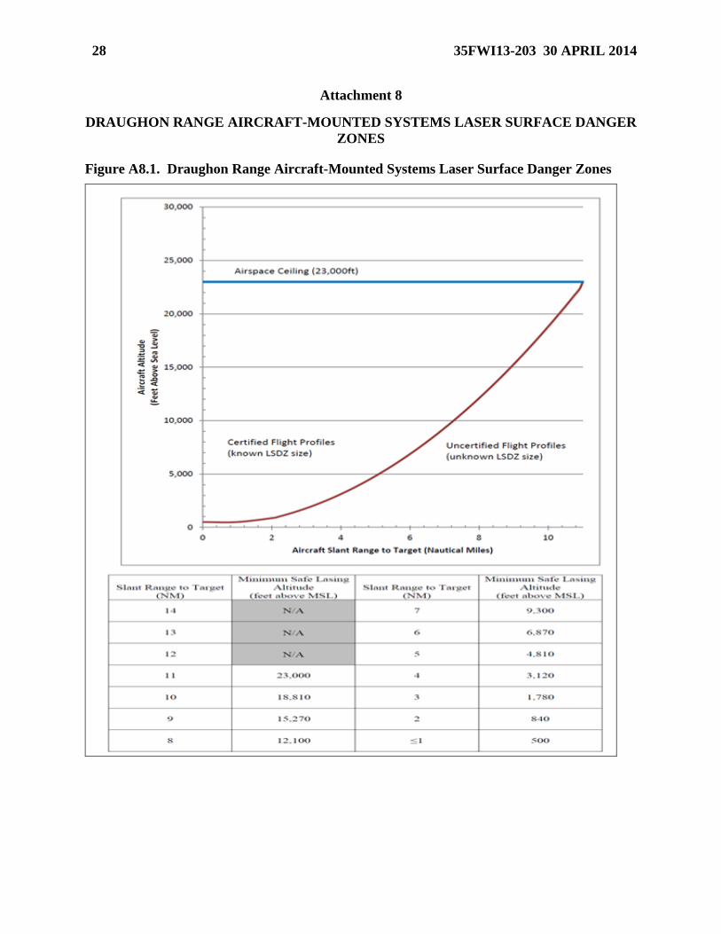
authorized.
2.10.2.4.5.1.4. Ensure the lasing aircraft sets a hard altitude while in the
wheel and stays inside the max orbit distance listed in Attachment 7.
2.10.3. IR Pointer (“Marker”) Employment: IR pointers referenced in this section are
laser command pointers (LCPs) (ACP-2A/2B, GCP-1A/1B/1C, LP-1000, IZLID 100P-
A1), ATPs (LITENING,SNIPER XR), and MTS (MQ-1/9). For simplicity, a reference to
“IR pointer” is a reference to all devices previously listed.
2.10.3.1. IAW 11-214, Laser Eye Protection (LEP) with side protection must be
worn when employing a LCP in the cockpit, where a reflection hazard exists, or
during a ground test.
2.10.3.2. IAW 11-214, aircrew will notify ground personnel and other aircraft in the
working area prior to employing IR pointer. When required, ground personnel will
ensure proper eye protection is in place.
2.10.3.3. Minimum Aircraft To Aircraft Slant Ranges: IAW 11-214, fixed-wing
aircraft will adhere to the following minimum slant range separation between IR
pointer employing aircraft and other aircraft (assumes no LEPs and no magnifying
devices are being used in other aircraft). 1,000 feet slant range for LCP (ACP-2A/2B,
16 35FWI13-203 30 APRIL 2014
GCP-1A/1B) and LITENING ATP, 2000 feet slant range for MTS and Sniper XR
ATP. 3,000 feet slant range for LCP (GCP-1C, LP-1000, IZLID 1000P-A1).
2.10.3.4. Minimum Employment Altitudes And Slant Ranges: IAW 11-214, if all
personnel in the area to be designated are wearing LEPs, the minimum IR pointer
employment altitude is 1,000 feet AGL for fixed-wing aircraft. In this case, there is
no minimum altitude for rotary-wing aircraft LCP employment provided the LCP is
not pointed toward any aircraft, person or specular surface (i.e. water, glass, mirrors,
reflecting surfaces, etc.).
2.10.3.4.1. IAW 11-214, if non-LEP equipped personnel are in the area to be
designated and it is verified that no image-magnifying devices (binoculars,
telescopes, etc.) are in use, minimum IR pointer employment slant range is 3,000
feet. If slant range cannot be determined the minimum employment altitude is
3,000 feet AGL.
2.10.3.4.2. IAW 11-214, if non-LEP equipped personnel are in the area to be
designated and unable to ensure the absence of personnel using image-magnifying
devices (binoculars, telescopes, etc.) in the area to be designated, IR pointer
employment is restricted as follows:
2.10.3.4.2.1. LCP (ACP-2A/2B, GCP-1A) and LITENING ATP. The
minimum slant range is 10,000 feet. If slant range cannot be determined the
minimum employment altitude is 10,000 feet AGL.
2.10.3.4.2.2. MTS. The minimum slant range is 14,000 feet. If slant range
cannot be determined the minimum employment altitude is 14,000 feet AGL.
2.10.3.4.2.3. Sniper XR ATP. The minimum slant range is 24,000 feet. If
slant range cannot be determined the minimum employment altitude is 24,000
AGL.
2.10.3.5. IAW 11-214, aircrew will make an “IR Pointer Safe” call when IR pointer
use is terminated for the mission and the safety cap (handheld LCP only) is in place.
2.10.4. Laser Safety And Reporting: IAW AFOSHSTD 48-139, every incident
involving a suspected laser radiation exposure to personnel covered by AFOSHSTD 48-
139 (e.g. military and DoD civilian personnel) will be investigated and documented.
(NOTE: Aircrew who receive a laser exposure from either friendly or hostile sources
should immediately report to the Flight Surgeon’s Office (FSO). The FSO will manage
and coordinate the event with the MAJCOM, USAFSAM/AFC, 311 HSW/YA and AFRL
as appropriate).
2.10.4.1. Individuals exposed will seek medical care, without delay, at their host
medical unit emergency treatment facility. THE LASER HOTLINE (1-800-473-
3549, this is a 24/7service number, please refer to local dialing procedures) SHOULD
BE CALLED ASAP BECAUSE IMMEDIATE INDICATED CARE IS CRITICAL.
The immediate supervisor will immediately notify the Unit Commander and Safety
Officer or LSO and the Bioenvironmental Engineer. The Bioenvironmental Engineer
will notify Wing Safety, Public Health services, Staff Judge Advocate, and MAJCOM
medical staff immediately.
35FWI13-203 30 APRIL 2014 17
2.10.5. No public releases of information concerning laser or IR Marker operations will
be made without 35 OSS/OSK, 35 FW/PA, NAF Liaison, 35 FW/CC coordination, and
USFJ/service-specific release authorities.
2.11. Minimum Recovery Altitude: Users will comply with the applicable AFIs/NATOPS
regulations but no lower than 75 feet AGL, whichever is higher.
2.12. Aircraft Emergency and Radio Failure Procedures:
2.12.1. Radio Failure (NORDO): The NORDO aircraft will safe all switches and should
maintain pattern spacing. The NORDO aircraft will fly near the main tower, rocking its
wings. On downwind, attempt contact on the Draughon Range back-up frequency. If
contact is made, the RCO will have the rest of the flight switch to the back-up frequency.
If radio contact is not made, remain VFR and fly 1000’ above the highest pattern briefed
rocking wings on final. Fly straight through for each subsequent pass. Squawk 7600 and
recover to Misawa. The RCO will notify Misawa RAPCON.
2.12.2. Safety: All flight leads are responsible for the overall safe conduct of the flight.
The RCO is responsible for ground safety, and acts as safety observer for all range
operations. The flight lead should pay special attention for boats, which may be in the
danger area offshore east of the range, or in the channel west of the range. The RCO will
ensure all safety precautions contained in this supplement are adhered to and report any
violation to the proper authorities in accordance with current regulations.
2.12.3. The RCO may call “KNOCK IT OFF” at any time during missions for safety of
flight.
2.12.4. Aircraft Crashes: Range operations will be terminated by the RCO if an aircraft
crashes on or near the range complex. The RCO will close the range and direct all
aircraft to break out of the pattern. If the crash is in an inaccessible or unknown region,
RESCAP aircraft may be requested to stay in the pattern, attempt to pinpoint the crash
location, and provide assistance to direct rescue forces to the scene. Misawa RAPCON
and Command Post will be contacted by the RCO with accident information.
2.12.5. Controlled Bailout (See Attachment 6): Controlled bailout is over Draughon
Range (MIS 360/10 or vectors from RAPCON if IMC) on an easterly heading at or above
2000' MSL.
2.12.5.1. Aircrew will notify SOF of intentions to proceed with controlled bailout.
Following SOF notification, SOF and/or aircrew will notify Draughon Range RCO of
intentions to proceed with controlled bailout.
2.12.5.2. Following Range notification, the RCO will activate the EMERGENCY
ACTION CHECKLIST.
2.13. Ground Operations/Training:
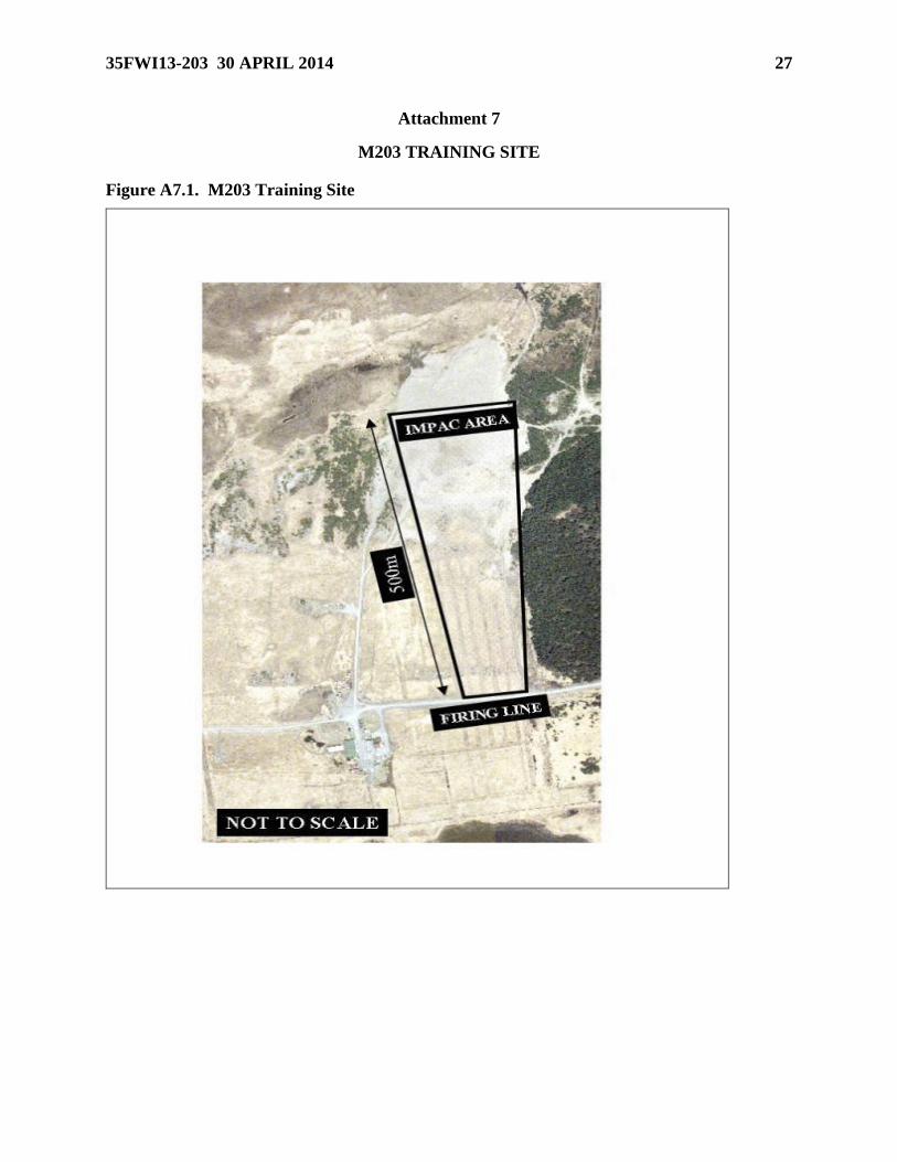
2.13.1. Combat Arms M203 Grenade Launcher Training Procedures:
2.13.1.1. Only the approved location will be utilized for M203, Grenade Launcher
Training (see Attachment 6).
2.13.1.2. Security Forces will be responsible for scheduling Draughon Range times
for M203, Grenade Launcher Training through 35 OSS/OSOS.
18 35FWI13-203 30 APRIL 2014
2.13.1.3. Security Forces will be responsible for environmental clean-up of the M203
Grenade Launcher Training area to include all expended rounds as well as targets
used during training.
2.13.1.4. Security Forces will respond to all Range Control Officer’s/Safety Officer
instructions/direction.
2.13.1.5. CATM personnel will be trained as unescorted personnel for the safety of
their trainees (see paragraph 1.7.1.2).
2.13.1.6. Combat arms training other than M203 is not authorized on Draughon
Range.
2.14. C-130 Procedures (see Attachments 3 and 4):
2.14.1. Establish a location for the drop zone with range management prior to the start of
operations.
2.14.2. Due to environmental conditions, alternate drop zone locations may be approved
for operations by the RCO.
2.14.2.1 It is the Airlift Squadron’s responsibility to retrieve loads. However, radios,
weather data, and 4-wheel drive vehicle support can be coordinated with range personnel.
Do not attempt to go beyond the Range Tower without a 4-wheel drive vehicle and
familiarity with Draughon Range terrain.
2.14.2.2. Use caution when retrieving loads. Bomb craters may make night retrieval
difficult or dangerous.
2.14.2.3. For night drops, loads should be marked with numerous lights to ensure
recoverability.
2.14.2.4. If any load, including Standard Airdrop Training Bundles (SATBs) impacts
off Draughon Range, notify the RCO immediately. The RCO will notify the 35
FW/CP, 374 AW/CP (225-2536), and the Mission Commander as soon as possible.
Every effort will be made by the Combat Mobility Element (CME) team to retrieve
all off-range drops. Results of the search will be forwarded to the Drop Zone Control
Officer (DZCO) and range operations personnel. In the event of personal or property
damage, loads will be undisturbed pending a mishap investigation.
2.14.2.4.1. User accepts responsibility for damage to equipment and property.
2.14.2.4.2 High winds are common at Draughon range. Aircrews must monitor
winds closely to ensure airdrops are conducted within limits.
2.14.2.5. Avoid Shimokita range located along the northeastern coast of Honshu.
Altitudes vary but can be as high as FL230. This range is activated by Japanese class
II NOTAMS and is not covered in the USAF NOTAM system.
35FWI13-203 30 APRIL 2014 19
Table 1. Coordinates are:
41-21.52'N 141-27.33'E 41-16.22'N 141-24.68'E 41-14.27'N 141-24.50'E
41-14.27'N 141-23.73'E 41-21.52'N 141-26.08'E 41-15.22'N 141-25.16'E
NOTE: Shimokita (Ground-to-Air, Ground-to-Ground Range) is operated by JASDF,
normally during the summer months, between 0800-1700L. Contact Misawa Base
Operations to determine if the range is active.
2.14.2.6. Beware of the Draughon Range strafe targets, which look like Raised Angle
Markers (RAMs).
2.14.3. IMC Drop Altitude: Plan minimum IMC drop altitudes at 500 feet above the
highest man-made obstacle or terrain feature and spot elevation, or 400 feet plus one
basic contour interval above the highest depicted basic terrain contour, whichever is
highest, within 3 NM either side of the run-in centerline from drop zone (DZ) entry point
to DZ exit point. Use the operational minimum drop altitudes in AFI 11-231, Computed
Air Release Point Procedures if higher. Instrument Flight Rules (IFR) drops and low
level routes must comply with Federal Aviation Administration (FAA) exemption 4371C.
2.14.4. IMC: Aircraft will be flown at least 2,000 feet (mountainous terrain) above the
highest contour elevation, man-made obstacle, or spot elevation within 10 NM of route
centerline. Airdrops will not be accomplished in IMC or through clouds. Aircrew must
be visual with the entire drop zone.
2.14.4.1. The computed air release point (CARP) should fall well east of the Range
Tower and inside of R-130 for airdrops using the 070-110 degrees MC run-in. To
avoid the possibility of airdrops on private property, do not drop if the CARP does
not meet these criteria.
2.14.4.1.1. DZ axis is limited to 070-110 degrees M and 250–290 degrees M
2.14.5. Hung Load/Salvo Procedures (See Attachment 2): For 090 or 115 degrees run-
ins, maintain drop altitude and DZ heading until over the ocean, for 270 degrees run-in,
breakout and turn left, maneuver east of the coast over the water until ready to Salvo.
Salvo over the water, within R-130, clear of any ships and notify the RCO prior to, and
after SALVO procedures are accomplished.
STEPHEN C. WILLIAMS, Colonel, USAF
Commander
20 35FWI13-203 30 APRIL 2014
Attachment 1
GLOSSARY OF REFERENCES AND SUPPORTING INFORMATION
References
AFI 13-312, Range Planning and Operations,
AFI 11-214, Air Operations Rules and Procedures, 14 Aug 2012
AFOSHSTD 48-139, Laser and Optical Radiation Protection Program, 25 Jul 2012
Adopted Forms
AF Form 847, Recommendation for Change of Publication, 22 Sep 2009
Abbreviations and Acronyms
DZ—Drop Zone
EOD—Explosive Ordinance Disposal
HAS—High Angle Strafe
HEI—High Explosive Incendiary
IRSSS—Improved Remote Strafe Scoring System
LAS—Low Angle Strafe
LCP—Laser Command Pointer
LEP—Laser Eye Protection
NOTAM—Notice to Airmen
NVG—Night Vision Goggles
ORM—Operational Readiness Management
PCA—Positive Control Area
PGM—Precision Guidance Munitions
QAE—Quality Assurance Evaluator
RAPCON—Radar Approach Control
RCO—Range Control Officer
ROA—Range Operations Agency
ROO—Range Operations Officer
RWR—Radar Warning Reciever
SOF—Supervisor of Flying
UXO—Unexploded Ordinance
WDZ—Weapons Danger Zone
WISS—Weapon Impact Scoring System
35FWI13-203 30 APRIL 2014 21
Attachment 2
DRAUGHON RANGE LOCATION
Figure A2.1. Draughon Range Location
22 35FWI13-203 30 APRIL 2014
Attachment 3
DANGER AREAS / JETTISON / SALVO AREA
Figure A3.1. Danger Areas / Jettison / SALVO Area
35FWI13-203 30 APRIL 2014 23
Attachment 4
CONFIGURATION/AUTHORIZED DELIVERIES
Figure A4.1. Configuration/Authorized Deliveries (1)
24 35FWI13-203 30 APRIL 2014
Figure A4.2. Configuration/Authorized Deliveries (2)
Authorized Deliveries
Conventional 080 CW 120 BDU-33 VLD / 10HD / 10LD / 20HI / 20LD / 30DB /
45HADB / 45HARB / DTOS
Conventional 235 CW 295 BDU-33 30DB / 45HADB / 45HARB
Tactical 065 CW 105 BDU-33
Mk-82/84 Inert1
20mm Inert
VLD / 10HD / 10LD / 20HI / 20LD / 30DB /
45HADB / 45HARB / DTOS / HAS3 / LAS
4
Tactical 235 CW 295 BDU-33
Mk-82/84 Inert1
30DB / 45HADB / 45HARB / LAS4
Strafe Pits 1-2 085 CW 105 20mm Inert LAS2
Strafe Pit 4 065 CW 105 20mm Inert HAS
IR Village All Dry Only Dry Only
JASDF All Dry Only Dry Only
HEI HAS 065 CW 155 20mm HEI HAS (HEI Only) 1Any HD weapon delivered LD must be hard-wired low-drag
2Min recovery altitude 500’ AGL when pits are frozen or cannot be cleared IAW AFI 13- 212
3TP (no HEI) allowed on center targets only
4LAS on tactical targets will be DRY only
35FWI13-203 30 APRIL 2014 25
Attachment 5
MISAWA PCA AND NO-FLY AREAS
Figure A5.1. Misawa PCA and No-Fly Areas
26 35FWI13-203 30 APRIL 2014
Attachment 6
PATTERNS HOLDING & HUNG ORDNANCE
Figure A6.1. Patterns Holding & Hung ordnance
35FWI13-203 30 APRIL 2014 27
Attachment 7
M203 TRAINING SITE
Figure A7.1. M203 Training Site
28 35FWI13-203 30 APRIL 2014
Attachment 8
DRAUGHON RANGE AIRCRAFT-MOUNTED SYSTEMS LASER SURFACE DANGER
ZONES
Figure A8.1. Draughon Range Aircraft-Mounted Systems Laser Surface Danger Zones
35FWI13-203 30 APRIL 2014 29
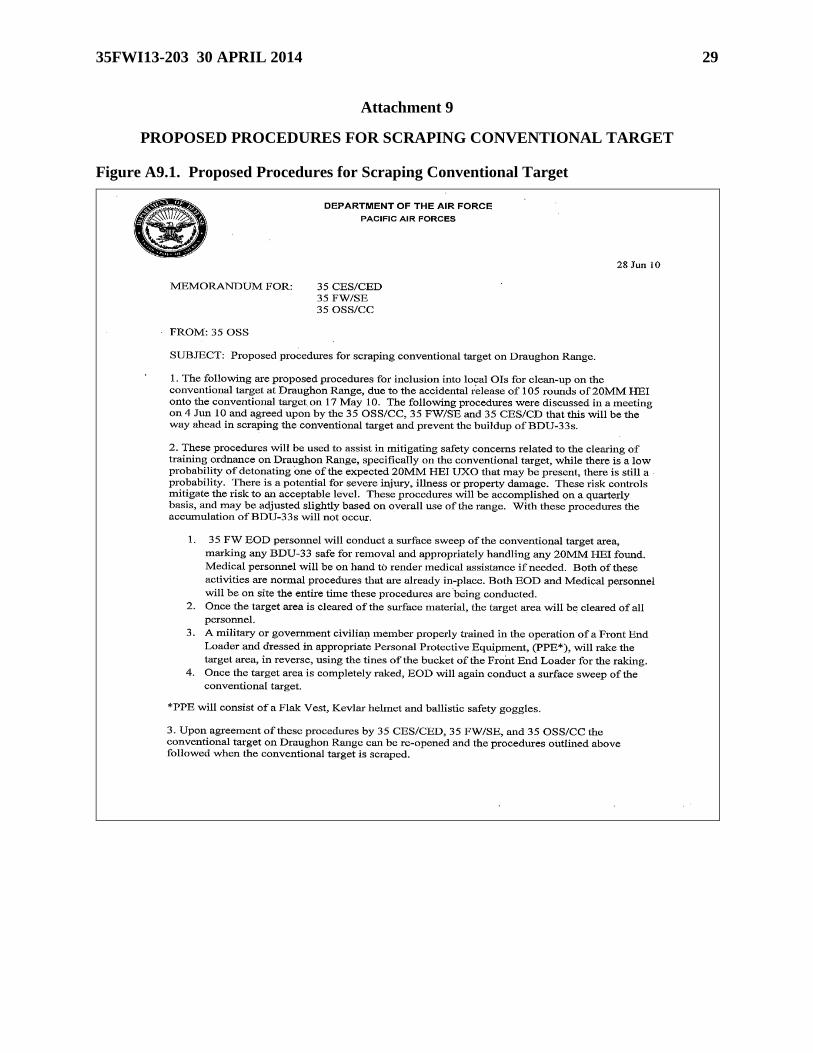
Attachment 9
PROPOSED PROCEDURES FOR SCRAPING CONVENTIONAL TARGET
Figure A9.1. Proposed Procedures for Scraping Conventional Target
30 35FWI13-203 30 APRIL 2014
35FWI13-203 30 APRIL 2014 31
Attachment 10
RISK ASSESSMENT FOR DRAUGHON RANGE
Figure A10.1. Risk Assessment for Draughon Range
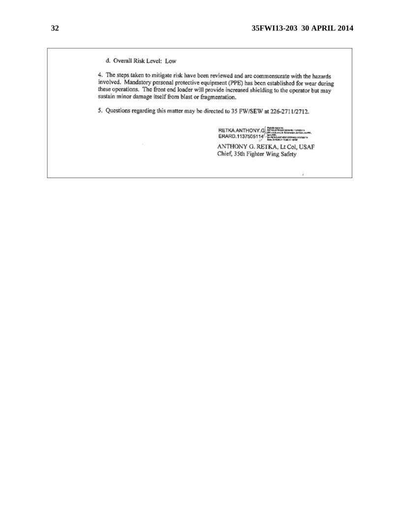
32 35FWI13-203 30 APRIL 2014