![Real Air Testing in Real Time.ppt [Read-Only]aii.transportation.org/Documents/AVApresentation.pdfFHWA-SA-96-062 The DBT work showed that their AVA data and that obtained using ASTM](https://static.fdocuments.in/doc/165x107/5e7997662c7e787bce25819f/real-air-testing-in-real-timeppt-read-onlyaii-fhwa-sa-96-062-the-dbt-work-showed.jpg)
Business Advantages of Using Electronic Engineering...
12
Business Business Advantages of Using Advantages of Using Electronic Engineering Electronic Engineering Data Data Dan Streett , PE & LS NYS Department of Transportation December 5, 2006 AGC/DOT Technical Conference
Transcript of Business Advantages of Using Electronic Engineering...
Business Business Advantages of Using Advantages of Using
Electronic EngineeringElectronic EngineeringDataData
Dan Streett , PE & LSNYS Department of Transportation
December 5, 2006AGC/DOT Technical Conference

December 5, 2006 2"Leveraging Data & Technology to Build Better Roads""Leveraging Data & Technology to Build Better Roads"
Types of Electronic Engineering DataTypes of Electronic Engineering DataCreated During Project DesignCreated During Project Design
• 3D Surfaces – Triangulated Display of Surface Points – Represent the Existing or Proposed Ground Terrain
• Point Data – Coordinate Position of Engineering Points in Real Space
• Alignment Data – A Series of Related Geometric Points or Lines• Graphics – Image Created Using Draped 3D Surfaces,
Engineering Features or Alignments, and Shapes• Storm & Sanitary – Database of Drainage and Sanitary Structure
and Pipe Line Information• Design Archive – Merged CADD Graphics, Alignments, 3D
Surfaces, Drainage Database and Pay Item Database• Electronic Documents – Digital Copies of Specifications,
Standards and Other Policies

December 5, 2006 3"Leveraging Data & Technology to Build Better Roads""Leveraging Data & Technology to Build Better Roads"
Uses for Electronic Engineering DataUses for Electronic Engineering DataDuring Contract ConstructionDuring Contract Construction
• Automated Quantities – Automates the Calculation of Quantities [InRoads Quantity Manager]
• Automated Stakeout – Coordinate & Elevation Positions Used With GPS or Total Station to Stakeout Points [Contractor Stakeout]
• Graphical Stakeout – Items to be Staked Out are Selected Graphically, With Survey GPS to Stakeout Features [CEI Toolset]
• Machine Navigation – Utilizes 3D Surfaces & Alignments to Guide Operation of Equipment
• Graphical Inspection – Items to be Inspected are Selected Graphically, With Survey GPS to Verify Items [CEI Toolset]
• On-Demand Information – Instant Access to Routine Documents, Available on Tablet or Handheld PC

December 5, 2006 4"Leveraging Data & Technology to Build Better Roads""Leveraging Data & Technology to Build Better Roads"
Electronic Engineering DataElectronic Engineering Data
Electronic Documents
[PDF]
Design Archive [Merged Data]
Storm & Sanitary [Database]
Graphics [3D Image]
Points [Coor & Elev]
3D Surfaces
[TriangulatedPoints]
Alignments[Horiz & Vert]
Electronic Engineering Data

December 5, 2006 5"Leveraging Data & Technology to Build Better Roads""Leveraging Data & Technology to Build Better Roads"
Data Uses In ConstructionData Uses In ConstructionApplications
Data Type Data Description
Existing or Proposed Terrain Surface w/Points and Breaklines
Just Points With Coordinates & Elevations
Points or Lines Assoc Together w/a Horiz and/or Vert Alignment
Points, Lines, Shapes & Solids Presented as a 3D Model
Database on all Storm & Sanitary Engineering Information
Merged Archive of All Above Engineering Information
PDF Copies of Pertinent Paper Policy Documents
On-
Dem
and
Info
rmat
ion
(Inst
ant F
ield
A
cces
s)
3D Surfaces (DTM)
Aut
omat
ed
Qua
ntiti
es
(Qua
ntity
M
anag
er)
Aut
omat
ed
Stak
eout
(C
ontr
acto
r St
akeo
ut)
Gra
phic
al
Stak
eout
(CEI
Too
lset
- St
akeo
ut)
Mac
hine
N
avig
atio
n
Alignment Data (Features)
Graphics (3D Images)
Storm & Sanitary (Database)
Gra
phic
al
Insp
ectio
n (C
EI T
ools
et -
Insp
ectio
n)
Design Archive (Merged Data)
Electronic Documents (Digital Paper)
Point Data (Coor & Elev)

December 5, 2006 6"Leveraging Data & Technology to Build Better Roads""Leveraging Data & Technology to Build Better Roads"
What is Wrong With 2D Paper?What is Wrong With 2D Paper?
Misinterpretation Misinterpretation of 2D Can Lead to of 2D Can Lead to Costly Mistakes, Costly Mistakes,
ReRe--Work & DelaysWork & Delays

December 5, 2006 7"Leveraging Data & Technology to Build Better Roads""Leveraging Data & Technology to Build Better Roads"
Visualize How Components Fit Together
Identify Construction or Vehicle Conflicts
Rotate or Move to View Different Perspectives
3D Data Use for Construction3D Data Use for Construction
Early Detection of Potential Underground Utility or Drainage Conflicts
Bridge Foundation Considerations
December 5, 2006 8"Leveraging Data & Technology to Build Better Roads""Leveraging Data & Technology to Build Better Roads"
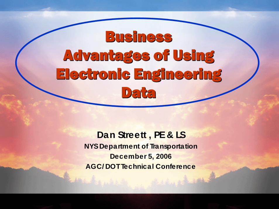
Machine Navigation SystemsMachine Navigation SystemsUtilizes 3D Surfaces & AlignmentsUtilizes 3D Surfaces & Alignments
Rough Grading w/GPSRough Grading w/GPS Fine Grading w/RTSFine Grading w/RTS
Trenching w/GPSTrenching w/GPS
Electronic Data Electronic Data Can Automate Can Automate Construction Construction OperationsOperations

December 5, 2006 9"Leveraging Data & Technology to Build Better Roads""Leveraging Data & Technology to Build Better Roads"
Benefits for Inspection & StakeoutBenefits for Inspection & Stakeout
STAKEOUT:• Select Features Graphically• Stakeout as Needed by Offset• On-Demand Proposed
Location and Elevation
INSPECTION:• Identify Feature Graphically• Verify Feature Information• Verify Position Instantly• Track Who & When Approved
This stuff is amazing!CEI TOOLSET CEI TOOLSET
HandsHands--On On Workshop Workshop
Thursday @ 8:30AM Thursday @ 8:30AM

December 5, 2006 10"Leveraging Data & Technology to Build Better Roads""Leveraging Data & Technology to Build Better Roads"
Return on Investment (ROI)Return on Investment (ROI)Eliminate Reverse Engineering – Provide Electronic Data Directly to Contractors for Field ConstructionGraphical Stakeout & Inspection – Features Can Be Positioned by Offset, Verified, Quantified and Approved by Inspectors Instantly in the Field Machine Guidance Systems – Estimated Dirt Savings:
50% Savings on Equipment – Less Use & Field Adjustments80% Savings on Survey – Little or No Roadway Stakeout75% Savings on Labor – Less Hand Work & Field Adjustments4% to 6% Savings on Material OverrunsPotential 5-10% Savings on Dirt ItemsBig Safety Benefits – Less People on the Ground
December 5, 2006 11"Leveraging Data & Technology to Build Better Roads""Leveraging Data & Technology to Build Better Roads"
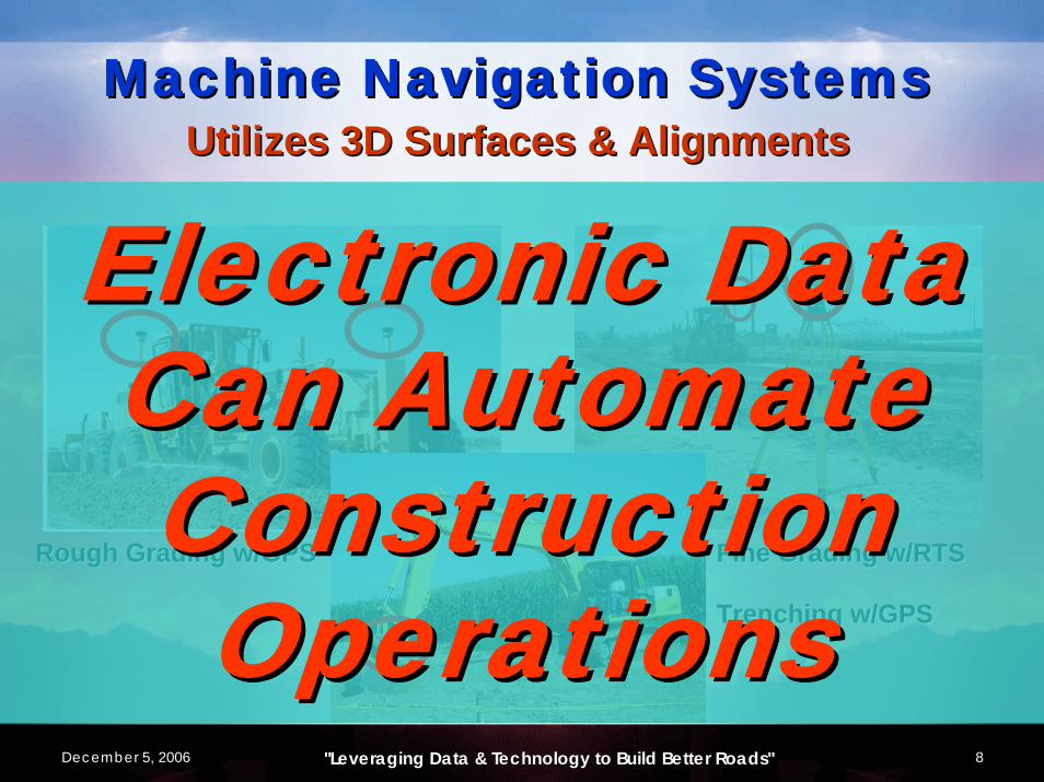
Electronic Data = Lower Risk Electronic Data = Lower Risk = Lower Costs= Lower Costs
Increases Confidence in Constructability of a ProjectReduces Chance of Encountering Unexpected ProblemsDecreases Manual Calculations – Increases Operational EfficiencyReduces Misinterpretation of 2D DesignsEliminates Need for Paper Cross Sections and PlanimetersFaster and More Accurate Earthwork Balance Calculations Prior to Bids

December 5, 2006 12"Leveraging Data & Technology to Build Better Roads""Leveraging Data & Technology to Build Better Roads"
-- Discussion Discussion --
-- Questions Questions --
-- Comments Comments --