![Ridgecrest Biology-Anderson 04-01-01.ppt [Read-Only] · 05/01/2010 · BURROWING OWL DESERT KIT FOX AND BURROWING OWL, DESERT KIT FOX AND ... Microsoft PowerPoint - Ridgecrest Biology-Anderson](https://static.fdocuments.in/doc/165x107/5adca05f7f8b9a1a088c37d0/ridgecrest-biology-anderson-04-01-01ppt-read-only-owl-desert-kit-fox-and-burrowing.jpg)
Burrowing Owl Survey Report - San Bernardino County · Burrowing Owl Survey Report . for the ....
15
Burrowing Owl Survey Report for the Joshua Tree Solar Farm San Bernardino County, CA United States Geological Survey 7.5-minute Joshua Tree North and Sunfair quadrangle Township 1 N, Range 7 E, Section 21 Assessor’s Parcel Numbers: 0607-364-06, 0607-231-07, 0607-231-09, 0607-231-10, 0607-231-11, 0607-231-12, 0607-231-13, 0607-231-14, 0607-231-15, and 0607-231-18 Prepared For: Joshua Tree Solar Farm, LLC 700 Universe Boulevard, Juno Beach, FL 33408 Contact: Andy Flajole, 206-937-1174 Prepared By: Tetra Tech, Inc. 350 Indiana Street, Suite 500 Golden, CO 80401 Contact: Emily Mix, 303-980-3509 and Alice E. Karl, Ph.D. P.O. Box 74006 Davis, CA 95617 530-304-4121 Field Work Conducted By: Dr. Alice Karl, Shawn Lindey, Emily Mix, Glenn Rink, and Jacqueline (Liz) Smith July 2015
Transcript of Burrowing Owl Survey Report - San Bernardino County · Burrowing Owl Survey Report . for the ....

Burrowing Owl Survey Report for the
Joshua Tree Solar Farm San Bernardino County, CA
United States Geological Survey 7.5-minute Joshua Tree North and Sunfair quadrangle
Township 1 N, Range 7 E, Section 21
Assessor’s Parcel Numbers: 0607-364-06, 0607-231-07, 0607-231-09, 0607-231-10, 0607-231-11, 0607-231-12, 0607-231-13, 0607-231-14, 0607-231-15, and 0607-231-18
Prepared For: Joshua Tree Solar Farm, LLC
700 Universe Boulevard, Juno Beach, FL 33408 Contact: Andy Flajole, 206-937-1174
Prepared By: Tetra Tech, Inc.
350 Indiana Street, Suite 500 Golden, CO 80401
Contact: Emily Mix, 303-980-3509
and
Alice E. Karl, Ph.D. P.O. Box 74006
Davis, CA 95617 530-304-4121
Field Work Conducted By:
Dr. Alice Karl, Shawn Lindey, Emily Mix, Glenn Rink, and Jacqueline (Liz) Smith
July 2015

Joshua Tree Solar Farm
ES-1
EXECUTIVE SUMMARY Joshua Tree Solar Farm, LLC (Applicant) is proposing to construct, own, and operate a 20 megawatt solar photovoltaic generating facility located on approximately 115-acres, referred to as the Joshua Tree Solar Farm (Project). The Project would be on private land in unincorporated San Bernardino County, California, located approximately 3.5 miles east of the town of Joshua Tree and one mile north of Twentynine Palms Highway (Hwy 62). The power produced by the Project would be transmitted to the local power grid via a 1-mile, 33-kilovolt generation-tie line overbuild of an existing line connecting to Southern California Edison’s existing Pinto line located south of the Project.
Burrowing owl (Athene cunicularia) surveys were conducted in Spring and Summer 2015 according to California Department of Fish and Wildlife (CDFW) survey guidelines described in the Staff Report on Burrowing Owl Mitigation (California Department of Fish and Game [CDFG] 2012), as clarified during discussions with CDFW. These followed earlier burrowing owl surveys in Spring 2012 that were conducted according to California Burrowing Owl Consortium (1993) guidelines. Surveys were conducted to determine the presence or potential absence of this pecies and its habitat within the Project site. The results of these surveys will be used to determine whether and to what extent this species would be affected by Project development.
No burrowing owls or their sign were detected during surveys in either year. However, there is the potential for burrowing owls to occur on site in the future because the entirety of the Project site and vicinity contains habitat suitable to support burrowing owl. Therefore, recommended measures to avoid and minimize potential Project impacts include but are not limited to: clearing vegetation outside of the nesting season, keeping construction disturbance to a minimum, having biological monitors present during fence construction and in unfenced areas, enforcing the designated speed limit, implementing weed management measures, and implementing a worker environmental awareness program. Avoidance surveys to determine whether owls are present at the time of construction should be performed within 14 days prior to construction. If owls are present and cannot be avoided, a Project-specific burrowing owl management plan should be developed in consultation with the California Department of Fish and Wildlife and the owls passively relocated accordingly.

Joshua Tree Solar Farm
i
TABLE OF CONTENTS
EXECUTIVE SUMMARY ........................................................................................................... 1
1.0 INTRODUCTION ............................................................................................................ 1 1.1 Project Description ................................................................................................. 1
2.0 FIELD METHODS .......................................................................................................... 2 2.1 2012 Burrowing Owl Survey Methods .................................................................... 2 2.2 2015 Burrowing Owl Survey Methods .................................................................... 3
3.0 RESULTS AND DISCUSSION ....................................................................................... 4
4.0 IMPACT ASSESSMENT AND RECOMMENDATIONS .................................................. 4
5.0 CERTIFICATION ............................................................................................................ 5
6.0 LITERATURE CITED ..................................................................................................... 6
LIST OF TABLES Table 1. 2012 Burrowing Owl Survey Times and Weather Conditions ........................................ 3 Table 2. 2015 Burrowing Owl Survey Times and Weather Conditions ........................................ 3
LIST OF FIGURES Figure 1 Regional Location Map Figure 2 Project Vicinity Map Figure 3 Biological Resources Survey Area
LIST OF APPENDICES Appendix A. CNDDB Burrowing Owl Occurrences within 10 Miles of the Project

Joshua Tree Solar Farm
1
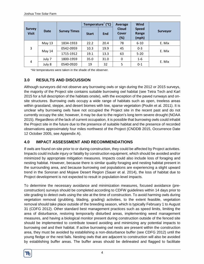
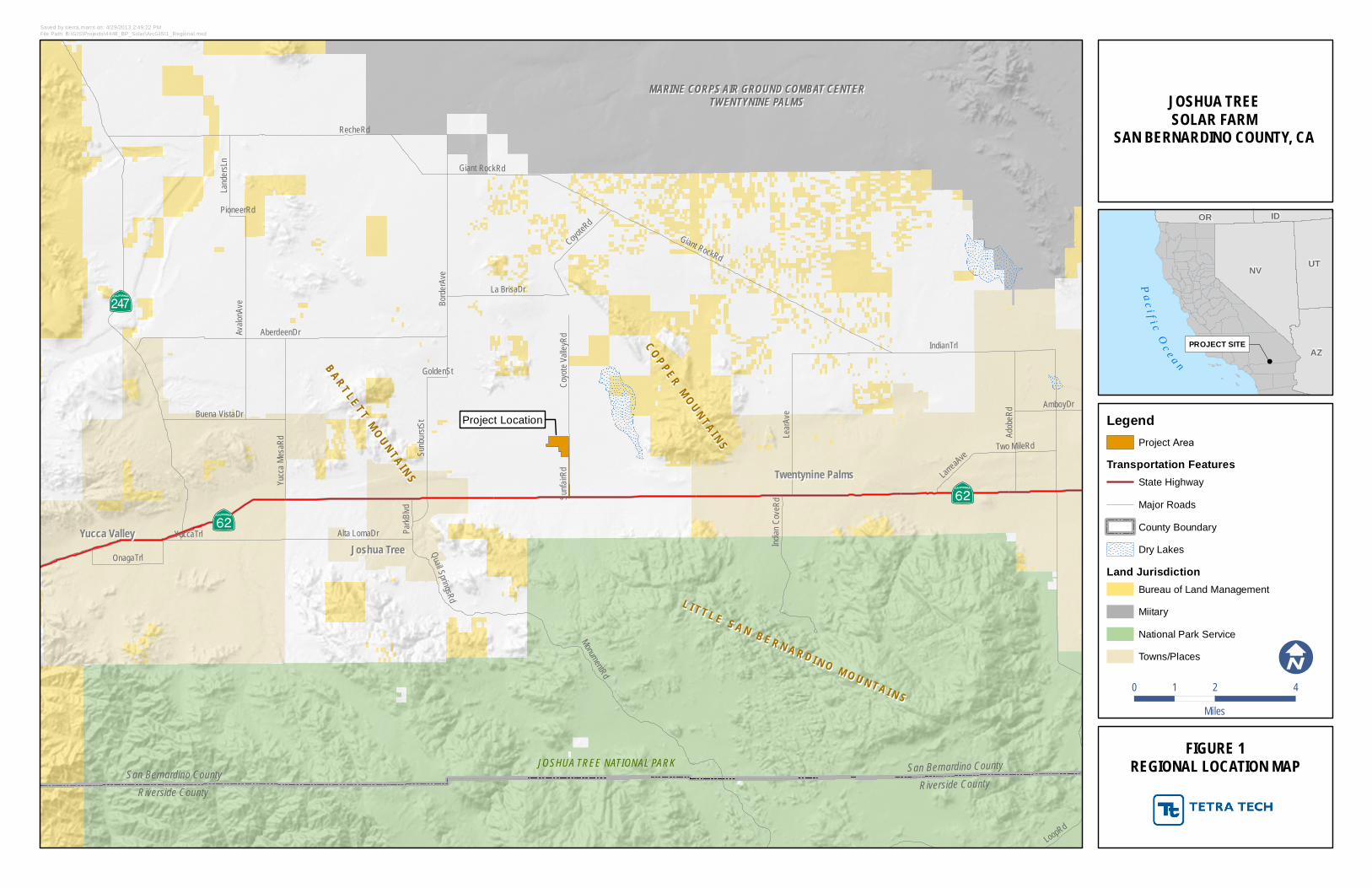
1.0 INTRODUCTION Joshua Tree Solar Farm, LLC (Applicant) is proposing to construct, own, and operate a 20 megawatt (MW) solar photovoltaic (PV) generating facility located on approximately 115-acres, referred to as the Joshua Tree Solar Farm (Project). The Project would be on private land in unincorporated San Bernardino County, California, located approximately 3.5 miles east of the town of Joshua Tree and one mile north of Twentynine Palms Highway (Hwy 62) (Figures 1 and 2). The power produced by the Project would be transmitted to the local power grid via a 1-mile, 33-kilovolt (kV) generation-tie line (gen-tie) overbuild of an existing line connecting to Southern California Edison’s (SCE’s) existing Pinto line located south of the Project.
The burrowing owl (Athene cunicularia) is a California Species of Special Concern and, although it is not listed by the federal or state Endangered Species Act, its potentially compromised status prompted a previous proposal for state listing. Even though the listing proposal was rejected, the burrowing owl remains a high-profile species with the resource agencies. It is also legally protected under the federal Migratory Bird Treaty Act and California Department of Fish and Game Codes 3503, 3503.5, and 3513. To determine the presence or potential absence of this species and its habitat within the Project site, focused burrowing owl surveys were conducted in Spring 2012 and Spring and Summer 2015. The results of these surveys will be used to determine whether and to what extent this species would be affected by Project development.
1.1 Project Description
The Project will be designed to consist of 20, one-MW alternating current (AC) array blocks. Each array block will be laid in a grid pattern across the site and will use solar PV modules that will be installed in uniform rows. The Project will convert energy captured from the sun to direct current electricity and then to AC electricity. Energy is expected to be generated from this Project during daylight hours every day of the year for over 30 years. The generated power will be delivered to the electrical grid via a 33-kV interconnection to the SCE distribution system. A detailed description of the Project site’s biological setting is presented in Tetra Tech and Karl (2015).
For the purposes of this document, the following terminology applies:
• “Project” is the Joshua Tree Solar Farm and includes the solar plant site and gen-tie line.
• “Project site” is the 115- acre area currently under consideration for development. It includes the solar plant site (modules, power conversion station, and switchgear). The area disturbed for development will be approximately 96 acres, but remains flexible to accommodate grading requirements and solar technology. The solar plant will be built within the Project site.
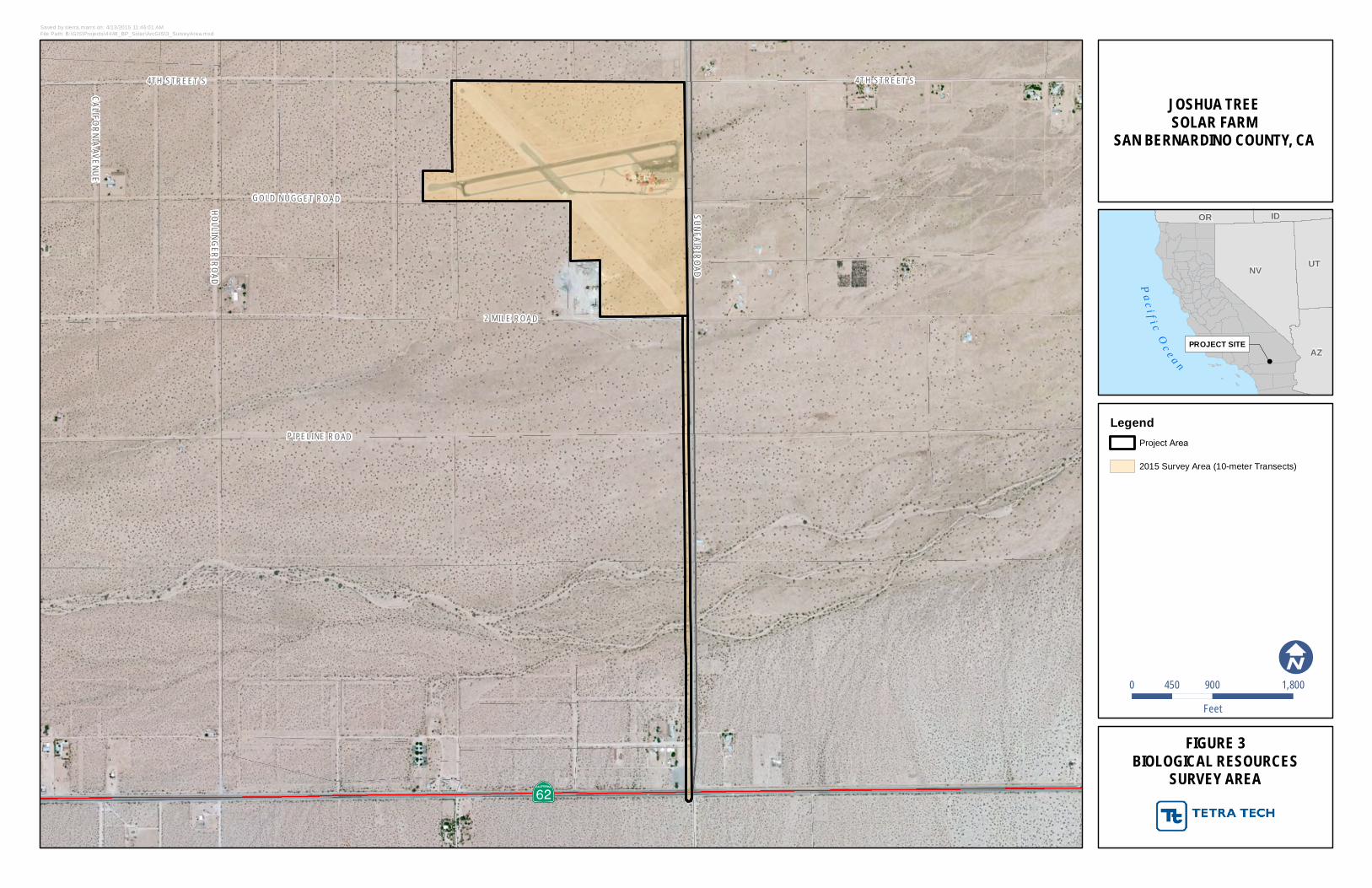
• “Survey area” is the area that was surveyed in Spring 2012 and Spring and Summer 2015 (Figure 3). It is equivalent to the Project site plus a 60-foot wide corridor for the gen-tie (7.4 acres).

Joshua Tree Solar Farm
2
2.0 FIELD METHODS 2.1 2012 Burrowing Owl Survey Methods
At the time of the 2012 surveys, the California Department of Fish and Wildlife (CDFW) generally required protocol surveys for burrowing owls that were consistent with the California Burrowing Owl Consortium (CBOC) Guidelines (CBOC 1993). The guidelines recommended a set of consecutive surveys, each following the previous based on the latter’s results:
• Phase I: Habitat Assessment – This “first step in the survey process is to assess the presence of burrowing owl habitat on the Project site including a 150-meter (approx. 500 feet) buffer zone around the Project boundary...”
“The Phase II burrow survey is required if burrowing owl habitat occurs on the site. If burrowing owl habitat is not present on the Project site and buffer zone, the Phase II burrow survey is not necessary.”
• Phase II: Burrow Survey – “A survey for burrows and owls should be conducted by walking through suitable habitat over the entire Project site and in areas within 500 feet (150 meters) () of the Project impact zone. This 500-foot buffer zone is included to account for adjacent burrows and foraging habitat outside the Project area and impacts from factors such as noise and vibration due to heavy equipment which could impact resources outside the Project area.”
• Phase III: Owl Presence – “If the Project site contains burrows that could be used by burrowing owls, then...surveys in the breeding season are required to describe if, when, and how the site is used by burrowing owls. If no owls are observed using the site during the breeding season, a winter survey is required.” The survey methodology requires four site visits, each on a separate day. Birds are observed from two hours before sunset to one hour after sunset, or from one hour before sunrise to two hours after sunrise. The four visits are initially conducted during the nesting season, February 1 to August 31, although it is preferable to survey at the height of the breeding season, between April 15 and July 15. If no owls are observed during the nesting season, then “winter surveys should be conducted between December 1 and January 31... (to) count and map all owl sightings, occupied burrows, and burrows with owl sign.”
Spring 2012 surveys were generally conducted according to CBOC guidelines with the exception of buffer surveys, which were not conducted due to access constraints1. Alice Karl, Emily Mix, and Tim Thomas conducted the Phase I survey on April 3, 2012. Surveyors determined that burrowing owl habitat was present throughout the Project survey area and vicinity and therefore Phase II surveys were required. The same survey crew completed Phase II surveys of the gen-tie route on April 4, 2012 and of the Project site on May 16, 2012 during the desert tortoise protocol surveys (Table 1). The adjoining areas within 150 meters or more were not surveyed on foot, but were visually assessed using binoculars. Surveyors mapped any burrowing owls or sign observed using a global positioning system [GPS] unit with <5 meter accuracy) and qualified the sign relative to age. As no burrowing owl or sign was observed during Phase II surveys, Phase III nesting-season surveys were not conducted.
1 Although we did not have access to most of the surrounding properties, we had surveyed a formerly
considered site south of the Project in 2012.

Joshua Tree Solar Farm
3
Table 1. 2012 Burrowing Owl Survey Times and Weather Conditions
Survey* Date Survey Times
Temperature** (°C) Average Cloud Cover
(%)
Wind Speed Range (mph)
Surveyor Start End
Phase I April 3 n/a - - - - A. Karl,
E. Mix, and T. Thomas
Phase II (gen-tie) April 4 1651-1721 25.4 25.1 5 2-9 E. Mix and
T. Thomas
Phase II (solar plant site) May 16
0653-1242 1630-1900
16.0 31.6 0 0-5 A. Karl,
E. Mix, and T. Thomas
* Weather data and survey times were not recorded for the Phase I Habitat Assessment. ** Air temperatures were taken in the shade of the observer.
2.2 2015 Burrowing Owl Survey Methods
In Spring 2015, surveys were generally conducted according to CDFW survey guidelines described in the Staff Report on Burrowing Owl Mitigation (CDFG 2012). Survey methods were reviewed and approved by CDFW prior to surveys.
Qualified biologists conducted four surveys by walking 25 meter or narrower transects of the Project site. The first survey was conducted by Alice Karl and Glenn Rink on April 1 and 2, 2015 during the desert tortoise and wildlife survey because those methods are intense, with transects spaced at 10 m (see Tetra Tech and Karl 2015). The subsequent three surveys focused exclusively on burrowing owl and were conducted by Shawn Lindey and Liz Smith on April 23, 2015, and by Emily Mix on May 13 and 14, and July 7 and 8, 2015 (Table 2). Surveyors mapped any burrowing owls or sign observed using a GPS unit with <5 meter accuracy and qualify the sign relative to age. All surveys were conducted between morning civil twilight and 10:00 am and/or two hours before sunset until evening civil twilight. Buffer surveys were not conducted due to access constraints. However, piles of cement rubble along and immediately outside the Project boundary that provide suitable burrowing owl habitat were thoroughly investigated for signs of owl presence.
Table 2. 2015 Burrowing Owl Survey Times and Weather Conditions
Survey Visit
Date Survey Times
Temperature* (°C) Average Cloud Cover
(%)
Wind Speed Range (mph)
Surveyor Start End
1 April 1
0627-1021 9.3 21.3 0 3-4 A. Karl, G. Rink
1707-1922 27.5 28.0 0 2-4 April 2 0627-0954 8.0 16.2 10 0-7 A. Karl, G. Rink
2 April 23 0500-0953 9.5 23.6 18 0-3 S. Lindey, L. Smith
Joshua Tree Solar Farm
4
Survey Visit
Date Survey Times
Temperature* (°C) Average Cloud Cover
(%)
Wind Speed Range (mph)
Surveyor Start End
3 May 13 1834-1933 22.2 20.4 78 6-10 E. Mix
May 14 0542-0959 10.3 19.9 45 0-3
E. Mix 1715-1912 19.1 13.3 63 5-20
4 July 7 1800-1959 35.0 31.0 0 1-6
E. Mix July 8 0540-0920 19 32 5 0-1
*Air temperatures were taken in the shade of the observer.
3.0 RESULTS AND DISCUSSION Although surveyors did not observe any burrowing owls or sign during the 2012 or 2015 surveys, the majority of the Project site contains suitable burrowing owl habitat (see Tetra Tech and Karl 2015 for a full description of the habitats onsite), with the exception of the paved runways and on-site structures. Burrowing owls occupy a wide range of habitats such as open, treeless areas within grassland, steppe, and desert biomes with low, sparse vegetation (Poulin et al. 2011). It is unclear why burrowing owls have not occupied the Project site in the recent past and do not currently occupy the site; however, it may be due to the region’s long term severe drought (NOAA 2015). Regardless of the lack of current occupation, it is possible that burrowing owls could inhabit the Project site in the future due to the presence of suitable habitat and the presence of recorded observations approximately four miles northwest of the Project (CNDDB 2015, Occurrence Date 12 October 2005, see Appendix A).
4.0 IMPACT ASSESSMENT AND RECOMMENDATIONS If owls are found on-site prior to or during construction, they could be affected by Project activities. Impacts could include injury or fatality by construction equipment, which should be avoided and/or minimized by appropriate mitigation measures. Impacts could also include loss of foraging and nesting habitat. However, because there is similar quality foraging and nesting habitat present in the surrounding area, and because burrowing owl populations are experiencing a slight upward trend in the Sonoran and Mojave Desert Region (Sauer et al. 2014), the loss of habitat due to Project development is not expected to result in population-level impacts.
To determine the necessary avoidance and minimization measures, focused avoidance (pre-construction) surveys should be completed according to CDFW guidelines within 14 days prior to site grading to detect owls using the site at the time of construction. To avoid harming owls during vegetation removal (grubbing, blading, grading) activities, to the extent feasible, vegetation removal should take place outside of the breeding season, which is typically February 1 to August 31 (CDFG 2012). Other standard best management practices such as speed limits, limiting the area of disturbance, restoring temporarily disturbed areas, implementing weed management measures, and having a biological monitor present during construction outside of the fenced site should be implemented to contribute toward avoiding and minimizing any potential impacts to burrowing owl and their habitat. If active burrowing owl nests are present within the construction area, they must be avoided by establishing a non-disturbance buffer (see CDFG 2012) until the young fledge or the nest fails. Nesting owls that are adjacent to construction will also be avoided by establishing buffer areas. The buffer areas should be delineated and flagged to facilitate


Joshua Tree Solar Farm
6
6.0 LITERATURE CITED California Burrowing Owl Consortium (CBOC). 1993. California Burrowing Owl Consortium Guidelines.
California Department of Fish and Game (CDFG). 2012. Staff Report on Burrowing Owl Mitigation. State of California Natural Resources Agency. 34 pp.
California Natural Diversity Database (CNDDB). 2015. California Department of Fish and Wildlife RareFind. Version 5.1.1.
National Oceanographic and Atmospheric Administration (NOAA). 2015. Palmer Drought Severity Index. Available online at: http://www.cpc.ncep.noaa.gov/products/analysis_monitoring/regional_monitoring/palmer.gif
Poulin, Ray, L. Danielle Todd, E. A. Haug, B. A. Millsap and M. S. Martell. 2011. Burrowing Owl (Athene cunicularia), The Birds of North America Online (A. Poole, Ed.). Ithaca: Cornell Lab of Ornithology; Retrieved from the Birds of North America Online: http://bna.birds.cornell.edu/bna/species/061doi:10.2173/bna.61
Sauer, J. R., J. E. Hines, J. E. Fallon, K. L. Pardieck, D. J. Ziolkowski, Jr., and W. A. Link. 2014. The North American Breeding Bird Survey, Results and Analysis 1966 - 2013. Version 01.30.2015 USGS Patuxent Wildlife Research Center, Laurel, MD
Tetra Tech, Inc. and A. E. Karl (Tetra Tech and Karl). 2015. Desert Tortoise Survey and General Biological Resources Assessment for the Joshua Tree Solar Farm, San Bernardino County, CA. Prepared for NextEra Energy Resources, LLC. 73 pp.

Joshua Tree Solar Farm
1
FIGURES
A¡EA¡E
MARINE CORPS AIR GROUND COMBAT CENTERMARINE CORPS AIR GROUND COMBAT CENTERTWENTYNINE PALMSTWENTYNINE PALMS
JOSHUA TREE NATIONAL PARK
AÔE
San Bernardino CountyRiverside County
San Bernardino CountyRiverside County
LL II TT TT LL EE SS AA NN BB EE RR NN AA RR DD II NN OO MM OO UU NN TT AA II NN SS
CCOOPP PPEERRMMOOUUNNTTAA II NNSS
BBAARRTT LLEE TTTT MMOOUUNNTTAA II NNSS
Project Location
RecheRd
IndianTrl
Giant RockRd
AberdeenDrAvalon
Ave
MonumentRdLea
rAve
Borde
rAve
YuccaTrl
Adobe
Rd
La BrisaDr
Sunbu
rstSt
Yucca
MesaR
d
CoyoteRd
Indian
CoveR
d
Alta LomaDr
Buena VistaDr
Quail SpringsRd
Lander
sLn
OnagaTrl
Two MileRd
Coyot
e Valle
yRd
LarreaAve
AmboyDrPa
rkBlvd
GoldenSt
PioneerRd
Sunfa
irRd
Giant RockRd
LoopRd
Yucca ValleyYucca Valley
Twentynine PalmsTwentynine Palms
Joshua TreeJoshua Tree
!
PROJECT SITE
P ac i f i cO c e a n
NV UT
AZ
OR ID
FIGURE 1REGIONAL LOCATION MAP
JOSHUA TREESOLAR FARM
SAN BERNARDINO COUNTY, CA
Saved by sierra.marrs on: 4/29/2013 2:49:22 PMFile Path: B:\GIS\Projects\4448_BP_Solar\ArcGIS\1_Regional.mxd
0 2 41Miles
I
LegendProject Area
Transportation FeaturesState Highway
Major Roads
County Boundary
Dry Lakes
Land JurisdictionBureau of Land Management
Miitary
National Park Service
Towns/Places
JOSHUA TREE NORTHJOSHUA TREE NORTH24K Topographic Map24K Topographic Map
SUNFAIRSUNFAIR24K Topographic Map24K Topographic Map
Copyright:© 2013 National Geographic Society, i-cubed
!
PROJECT SITE
P ac i f i cO c e a n
NV UT
AZ
OR ID
FIGURE 2PROJECT VICINITY
USGS TOPOGRAPHIC MAP
JOSHUA TREESOLAR FARM
SAN BERNARDINO COUNTY, CA
Saved by sierra.marrs on: 4/29/2013 2:34:57 PMFile Path: B:\GIS\Projects\4448_BP_Solar\ArcGIS\2_Vicinity_USGS.mxd
0 2,000 4,0001,000Feet
I
LegendProject Area
USGS 1:24,000 Quadrangles
A¡E
4TH STREET S
GOLD NUGGET ROAD
2 MILE ROAD
HOLLINGERROAD
CALIFORNIAAVENUE
SUNFAIRROAD
4TH STREET S
PIPELINE ROAD
!
PROJECT SITE
P ac i f i cO c e a n
NV UT
AZ
OR ID
FIGURE 3BIOLOGICAL RESOURCES
SURVEY AREA
JOSHUA TREESOLAR FARM
SAN BERNARDINO COUNTY, CA
Saved by sierra.marrs on: 4/13/2015 11:46:01 AMFile Path: B:\GIS\Projects\4448_BP_Solar\ArcGIS\3_SurveyArea.mxd
0 900 1,800450Feet
I
LegendProject Area
2015 Survey Area (10-meter Transects)

Joshua Tree Solar Farm
2
APPENDIX A
CNDDB BURROWING OWL OCCURRENCES WITHIN 10 MILES OF THE PROJECT

¬«82
!
PROJECT SITE
P ac i f i cO c e a n
NV UT
AZ
OR ID
APPENDIX ACNDDB BURROWING OWL OCCURRENCES
WITHIN 10 MILES OF THE PROJECT
JOSHUA TREESOLAR FARM
SAN BERNARDINO COUNTY, CA
B:\GIS\Projects\4448_BP_Solar\ArcGIS\App_A_BUOW_CNDDB_10mi.mxd
0 2 41Miles
I
Legend
Project Site10-mile BufferCNDDB Burrowing Owl Occurrences
CNDDB data: July 2015 monthly release.