Burnley’s Local Plan: Background Paper 1: Site Allocations
20
Burnley’s Local Plan: Background Paper 1: Site Allocations Burnley Borough Council April 2017
Transcript of Burnley’s Local Plan: Background Paper 1: Site Allocations

Burnley’s Local Plan: Background Paper 1: Site Allocations Burnley Borough Council April 2017

2
Contents
1 Introduction ................................................................................................................... 3
1.1 What is a Background Paper? .................................................................................................. 3 1.2 What does this Background Paper cover? ............................................................................... 3 2 The Evidence Base .......................................................................................................... 3
2.1 What studies are relevant to site selection? ........................................................................... 3 2.2 The Strategic Housing Market Assessment (SHMA) ................................................................ 3 2.3 Gypsy Traveller and Travelling Showpeople’s Accommodation Assessment GTAA) ............... 4 2.4 The Employment Land Demand Study (ELDS) ......................................................................... 5 2.5 The Strategic Housing Land and Employment Availability Assessment (SHLAA) .................... 6 2.6 The SFRA .................................................................................................................................. 9 2.7 The Plan Viability Assessment................................................................................................ 10 2.8 The Infrastructure Delivery Plan (IDP) ................................................................................... 10 2.9 The SA/SEA ............................................................................................................................. 11 2.10 The Habitats Regulations Assessment (HRA) ......................................................................... 11 2.11 Site Specific Evidence ............................................................................................................. 12 3 Choosing the Developable sites for Allocation ............................................................... 13
3.1 Making the Choices – All Sites ............................................................................................... 13 The NPPF ...............................................................................................................................13 The Iterative Process .............................................................................................................13 The Spatial Strategy ..............................................................................................................14
3.2 How do consultation responses influence site selection? ..................................................... 14 3.3 Housing Sites .......................................................................................................................... 15
Deliverability and the 5 Year Housing and Supply ................................................................16 3.4 Employment Sites .................................................................................................................. 16 3.5 Gypsy and Traveller Sites ....................................................................................................... 17 3.6 Conclusion .............................................................................................................................. 17 Appendix 1: Housing Allocations by Site type ........................................................................... 18
Appendix 2: Housing Allocations by Density and House type .................................................... 19

3
1 Introduction
1.1 What is a Background Paper?
1.1.1 Background Papers are prepared to help people understand key elements of the plan-making process. These are not formal requirements of plan-making but are intended to aid understanding of particular parts of the process that may not be clear or easy to follow; often as indicated by consultation responses.
1.2 What does this Background Paper cover?
1.2.1 This paper summarizes the process taken in identifying sites for allocation of housing, employment and Gypsy and Traveller use in the new Burnley Local Plan.
1.2.2 The decision to include a site for allocation is based on facts and judgments. It is informed by a number of background technical studies (the evidence base) some of which are required for plan making by national policy. It is also informed by consultation responses. All the sites identified for allocation and their ‘reasonable alternatives’ are subject to Sustainability Appraisal and Strategic Environmental Assessment (combined). All proposed allocations are subject to Habitats Regulations Assessment.
1.2.3 Ultimately, the decision to include a site in the Proposed Submission Plan (March 2017) is made by elected Councillors who are recommended to approve the Plan for submission based on recommendations from the planning officers using their professional judgment.
1.2.4 The process of site selection, the Plan and the evidence base will be tested by the independent inspector who will be appointed to Examine the Plan to ensure the Plan is both legally compliant and sound.
1.2.5 Further information on the plan process and consultation stages is set out in the Council’s SCI. http://www.burnley.gov.uk/sites/default/files/SCI%202015%20Adopted%20Version.pdf
2 The Evidence Base
2.1 What studies are relevant to site selection?
2.1.1 The site assessment and selection process is informed by a number of assessments and studies. Some are mandatory (required by law or national policy) others are optional depending on the issues in the area that the plan is seeking to address.
2.1.2 The studies undertaken in Burnley that are of direct relevance to site selection process are: The Strategic Housing Market Assessment (SHMA); The Employment Land Demand Study (ELDS); The Strategic Housing Land and Employment Availability Assessment (SHLAA); The Gypsy and Traveller Accommodation Assessment (GTAA); The Local Plan Viability Study; The Infrastructure Delivery Plan (IDP); The Strategic Flood Risk Assessment (SFRA); The Sustainability Appraisal (incorporating a Strategic Environmental Assessment (SA/SEA) and the Habitats Regulations Assessment (HRA). These are described in summary below and can be downloaded for the Council’s website. www.burnley.gov.uk/residents/planning/planning-policies/burnleys-emerging-local-plan/evidence-base
2.2 The Strategic Housing Market Assessment (SHMA)
2.2.1 Paragraph 159 of the National Planning Policy Framework (NPPF) states that local planning authorities should prepare a Strategic Housing Market Assessment (SHMA) to assess their full housing needs, working with neighbouring authorities where housing market areas cross administrative boundaries. The Strategic Housing Market Assessment should identify the scale and

4
mix of housing and the range of tenures that the local population is likely to need over the plan period which:
• meets household and population projections, taking account of migration and demographic change;
• addresses the need for all types of housing, including affordable housing and the needs of different groups in the community (such as, but not limited to, families with children, older people, people with disabilities, service families and people wishing to build their own homes), and;
• caters for housing demand and the scale of housing supply necessary to meet this demand.
2.2.2 Consistent with this requirement, the Burnley SHMA assesses the overall housing need and demand for both market and affordable housing. This is called the ‘Objectively Assessed Need’ (OAN). The SHMA doesn’t only look at number of dwellings required but also the types and tenures of dwellings required to meet the needs and demand of all section of the community, including current residents, newly forming households, migrants and immigrants, over the plan period. Whilst the SHMA does not set policy, councils are required by the NPPF to ensure their Local Plan “meets the full, objectively assessed needs for market and affordable housing in the housing market area, as far as is consistent with the policies set out in this Framework.” (para 47 of the NPPF)
2.2.3 In Burnley’s case, the Housing Market Area is the boroughs of Burnley and Pendle and the two Councils have worked jointly on the SHMA.
2.2.4 Following the publication of the NPPF and the revocation of the Regional (Spatial) Strategies which previously set housing numbers, Burnley and Pendle Councils commissioned Nathaniel Lichfield & Partners (NLP) to carry out a SHMA on their behalf. This joint SHMA was produced in December 2013. However, due to the different stages of plan progress the two Councils are at, each has separately commissioned updates to the SHMA from NLP but these updated studies are aligned across the HMA.
2.2.5 The evidence in the SHMA is used to set the Plan’s housing requirement and therefore the quantity of sites to be chosen. It is also used to inform the type of sites required to ensure that in so far as is possible, the Plan delivers and supports housing to meet everyone’s needs and demands.
2.2.6 The borough’s updated SHMA (2016) identifies an Objectively Assessed Need (OAN) as ranging from 2,344 to 4,308 dwellings over the plan period, equivalent to 117 to 215 dwellings per annum (dpa). In order to meet the latest population and housing projections, to allow for the borough’s economic aspirations and to significantly boost the quality and choice of housing in the borough, the Council has identified a proposed target of 4,180 dwellings over the plan period, equivalent to 209 dpa. This figure is towards the top of the OAN range established in the SHMA. As the targets and SHMA run from 2012 to 2032, some of the housing requirement has already been delivered. (See Policy SP2 of the Local Plan)
2.2.7 Until recently SHMAs did not assess the need and demand for Gypsy Traveller and Travelling Showpeople’s accommodation and this was done in a separate ‘GTAA’. In future these assessments will be incorporated into SHMAs.
2.3 Gypsy Traveller and Travelling Showpeople’s Accommodation Assessment GTAA)
2.3.1 Current Government planning policy for Gypsies and Travellers is found in ‘Planning Policy for Traveller Sites’ (DCLG, 2015). This highlights that the traditional and nomadic way of life of Gypsies, Travellers and Travelling Showpeople should be facilitated while respecting the interests of the settled community. It indicates that planning authorities should use a robust evidence base to establish the likely permanent and transit accommodation needs of Traveller communities to inform

5
the preparation of Local Plans. Based on any need identified, Gypsy and Traveller pitch targets and Travelling Showpeople plot targets should be set, and a supply of specific deliverable sites sufficient to provide five years’ worth of provision detailed in the Local Plan. Additionally, a supply of specific, developable sites or broad locations for growth for years 6 – 10 and, where possible, years 11 – 15 should be identified.
2.3.2 In May 2012, Burnley and Pendle Councils commissioned the Housing and Urban Studies Unit at the University of Salford to produce a Gypsy, Traveller and Travelling Showpeople’s Accommodation Assessment (GTAA).
2.3.3 In 2015, ‘Planning Policy for Traveller Sites’ was updated and the definition of Gypsies and Travellers for planning purposes changed to: “Persons of nomadic habit of life whatever their race or origin, including such persons who on grounds only of their own or their family’s or dependents’ educational or health needs or old age have ceased to travel temporarily, but excluding members of an organised group of travelling showpeople or circus people travelling together as such”. In light of this change, only those members of the Gypsy and Traveller community who still travel, or can be reasonably said to intend to live a nomadic lifestyle in the future, require their needs to be specifically and separately addressed in the Local Plan. For those who don’t, their needs, requirements and demands, including for caravan living would be addressed along with those of the non-traveller community through the SHMA.
2.3.4 Following the 2015 change of definition, the survey results from the 2012 GTAA were revisited to reassess the need on the basis of the new national definition and a revised requirement figure of 5 pitches has been identified, and in accordance with national policy, the Local Plan identifies land for allocation to meet the specific known need of 5 pitches, including household growth to 2026.
2.4 The Employment Land Demand Study (ELDS)
2.4.1 The Employment Land Demand Study (ELDS) provides an important part of the evidence base to inform the preparation of the Local Plan by assessing economic development needs objectively in line with the National Planning Policy Framework (NPPF) and National Planning Practice Guidance (NPPG). The ELDS provides an understanding of the current and potential future requirements for employment land considering a range of scenarios. B1, B2 and B8 use classes are assessed in the study.
2.4.2 The Town and Country Planning (Use Classes) Order 1987 (as amended) puts uses of land and buildings into various categories known as 'Use Classes'. Generally planning permission is needed to change from one use class to another, although there are exceptions where the legislation does allow some changes between uses. The ‘B’ use classes are set out below. Uses that don’t fall into any other use class are known as Sui Generis.
Table 1: B Use Classes
Use Class Use/Description of Development
B1: Business a) Offices, other than a use within Class A2 (Financial services) b) Research and development of products or processes c) Light industry
B2: General Industrial Use for the carrying out of an industrial process other than one falling in Class B1
B8: Storage & Distribution Use for storage or distribution centre

6
2.4.3 The evidence in the ELDS is used to set out the Plan’s employment land requirement and therefore the quantity of sites to be chosen. It identifies the employment land Objectively Assessed Need (OAN) as ranging from 68Ha to 104Ha over the plan period. Within that range, the Council identified the proposed requirement/target figure of 90Ha over the Plan period as the figure which will best support the Plan’s vision and objectives, meet the Council’s economic growth aspirations and support economic growth and housing market renewal. This figure was the identified figure for ‘high growth’ in the Issues & Options draft of the Local Plan. As the target from the ELDS runs from 2012 to 2032 some of the employment land requirement has already been delivered. (See Policy SP3 in the Local Plan)
2.5 The Strategic Housing Land and Employment Availability Assessment (SHLAA)
2.5.1 Paragraph 159 of the NPPF requires that councils “prepare a Strategic Housing Land Availability Assessment to establish realistic assumptions about availability, suitability and likely economic viability of land to meet the identified housing need over the plan period.” These assessments are known as SHLAAs. Paragraph 161 of the NPPF goes on to say that “Reviews of land available for economic development should be undertaken at the same time as, or combined with, Strategic Housing Land Availability Assessments and should include a reappraisal of the suitability of previously allocated land.”
2.5.2 The Government’s National Planning Practice Guidance sets out a methodology for undertaking SHLAAs. The Council has undertaken a combined housing and employment land assessment but has still called this the SHLAA for ease of reference. The SHLAA is dual purpose: it both informs the Local Plan and also provides monitoring information of how a plan is performing and in particular the Council’s 5 year housing land supply position.
2.5.3 In terms of informing the plan, as the Burnley SHLAA does, the SHLAA can be seen as the first stage in the search for new sites for allocation. The SHLAA looks as sites with a smaller size (0.15 housing, 0.25Ha land/500m2 building employment) than the proposed allocation threshold in the local plan (0.4 hectares) because it also informs the overall spatial approach of the plan: i.e. it helps assess whether there are sufficient sites within existing development boundaries to accommodate the emerging Plan’s requirement (both through new allocations and as windfalls/small sites); whether sites beyond these boundaries be required; whether Green Belt release be required; or whether other Councils should be asked to look at taking Burnley’s housing or employment growth. National policy is clear that growth (i.e. need and demand) must be accommodated.
2.5.4 The first Burnley SHLAA was completed in June 2016 and an update produced in March 2017. The 2016 SHLAA included a map of the sites that has been considered and lists of the site conclusions, but it did not include individual site pro-formas. The SHLAA update does.
2.5.5 The SHLAA pro-formas set out in summary form only, the main technical and planning considerations looked at in considering whether to further consider (in the case of sites of 0.4 hectares or over) the allocation of the sites for housing or employment development in the Local Plan, or for sites of less than 0.4 hectares whether the site is likely to come forward as a ‘windfall’ (unallocated site). The pro-formas are designed and published to help interested parties understand the site selection process and to supply factual information to help inform their comments.
2.5.6 Whilst the information and matters summarised in these pro-formas will inform the decisions, they should not be interpreted to be the only matters considered, for example, cumulative scale in relation to existing settlements and communities and cumulative impact on landscape may also be factors, as will be the responses to public consultation. The selection of sites is also influenced by the Plan’s chosen strategy and the objectives of the plan and vice versa, and these have yet to be ‘tested’ at independent Examination.

7
Summary of the SHLAA process used
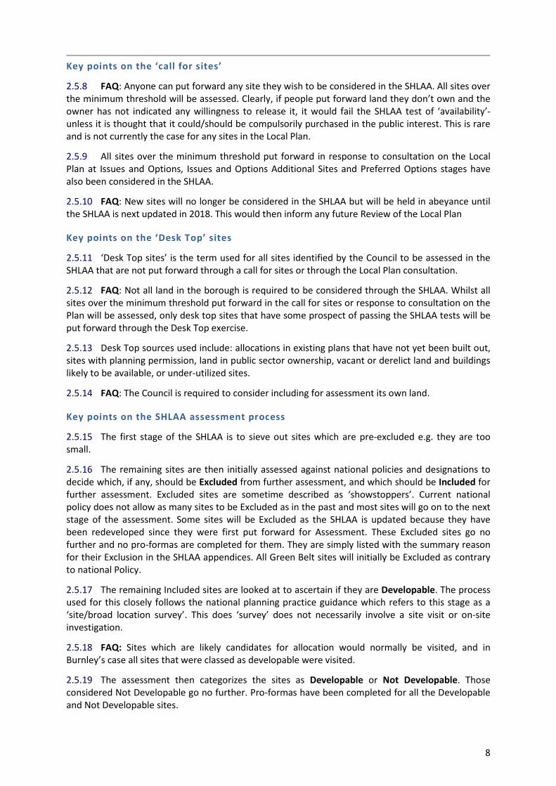
2.5.7 The full SHLAA history and the process used is set out in the SHLAA report and is summarised in figure 1 below. Whilst the process is not explained in detail in this paper, the key aspects of the process and aspects which have raised queries and question in consultation responses and at consultation events are marked as FAQ.
Fig 1: Summary of SHLAA Process
Stage as desribed in NPPG:
Determine the assessment area and site threshold (size)
and exclusion criteria
Stage 1: Site/ broad location identification
Desk top review of
site sources
Call for sites and broad locations
Survey of sites identifying
contstaints and possible mitigation
Excluded Sites
Stage 2: Site/ broad location identification assessmnet: Estimating the Devlopment Potential
Available
Suitable
Achievable (including viability)
Developable
Deliverable
Not Developable
Stage 3: Windfall assessment
Determine the supply of windfall sites
Prepare draft
Trajectory
Satge 4: Assessment Review
Review earlier stages
if necessary
Stage 5: Final Evidence Base
Informs 5 year land supply calculations
Informs the Local Plan
8
Key points on the ‘call for sites’
2.5.8 FAQ: Anyone can put forward any site they wish to be considered in the SHLAA. All sites over the minimum threshold will be assessed. Clearly, if people put forward land they don’t own and the owner has not indicated any willingness to release it, it would fail the SHLAA test of ‘availability’- unless it is thought that it could/should be compulsorily purchased in the public interest. This is rare and is not currently the case for any sites in the Local Plan.
2.5.9 All sites over the minimum threshold put forward in response to consultation on the Local Plan at Issues and Options, Issues and Options Additional Sites and Preferred Options stages have also been considered in the SHLAA.
2.5.10 FAQ: New sites will no longer be considered in the SHLAA but will be held in abeyance until the SHLAA is next updated in 2018. This would then inform any future Review of the Local Plan
Key points on the ‘Desk Top’ sites
2.5.11 ‘Desk Top sites’ is the term used for all sites identified by the Council to be assessed in the SHLAA that are not put forward through a call for sites or through the Local Plan consultation.
2.5.12 FAQ: Not all land in the borough is required to be considered through the SHLAA. Whilst all sites over the minimum threshold put forward in the call for sites or response to consultation on the Plan will be assessed, only desk top sites that have some prospect of passing the SHLAA tests will be put forward through the Desk Top exercise.
2.5.13 Desk Top sources used include: allocations in existing plans that have not yet been built out, sites with planning permission, land in public sector ownership, vacant or derelict land and buildings likely to be available, or under-utilized sites.
2.5.14 FAQ: The Council is required to consider including for assessment its own land.
Key points on the SHLAA assessment process
2.5.15 The first stage of the SHLAA is to sieve out sites which are pre-excluded e.g. they are too small.
2.5.16 The remaining sites are then initially assessed against national policies and designations to decide which, if any, should be Excluded from further assessment, and which should be Included for further assessment. Excluded sites are sometime described as ‘showstoppers’. Current national policy does not allow as many sites to be Excluded as in the past and most sites will go on to the next stage of the assessment. Some sites will be Excluded as the SHLAA is updated because they have been redeveloped since they were first put forward for Assessment. These Excluded sites go no further and no pro-formas are completed for them. They are simply listed with the summary reason for their Exclusion in the SHLAA appendices. All Green Belt sites will initially be Excluded as contrary to national Policy.
2.5.17 The remaining Included sites are looked at to ascertain if they are Developable. The process used for this closely follows the national planning practice guidance which refers to this stage as a ‘site/broad location survey’. This does ‘survey’ does not necessarily involve a site visit or on-site investigation.
2.5.18 FAQ: Sites which are likely candidates for allocation would normally be visited, and in Burnley’s case all sites that were classed as developable were visited.
2.5.19 The assessment then categorizes the sites as Developable or Not Developable. Those considered Not Developable go no further. Pro-formas have been completed for all the Developable and Not Developable sites.

9
2.5.20 The Developable sites are then looked at to see:
• If any of these that are 0.4 hectares or over should be allocated for housing, employment or as mix of uses in the Local Plan – see section 3 of this paper
• If any of these that are under 0.4 hectares could support windfall development against the current Local Plan and how many of these are likely to come forward – this influences the number of sites and type of sites that need to be allocated.
• If the emerging plan’s policies would support windfall development on these small sites and how many are likely to come forward – this influences the number of sites any type of sites that need to be allocated
• If national policy would support their allocation
• If there are sufficient sites to meet the emerging requirement in qualitative and qualitative terms
2.5.21 For the Burnley SHLAA, because it is informing a new plan, the developability of sites is not solely judged against the current adopted local plan policies but instead against national policies and the emerging new plan which has not yet been tested at independent examination, so the results are indicative.
2.5.22 The Assessments do not in themselves determine whether a site should be allocated for a specific use or be granted planning permission for housing or employment development. Allocations must be determined through the statutory development plan process where proposals are subject to extensive consultation, testing, Sustainability Appraisal, Strategic Environmental Assessment and Habitats Regulations Assessment. It is also important to note that the SHLAA may identify a site as developable for either housing or employment use but the Local Plan may identify a preferred use, or allocation such at Protected Open Space that would preclude development altogether. It is important to note that future SHLAA updates will assess sites against the newly adopted policies and so some sites currently classed as suitable for the purposes of this SHLAA will be re-categorised.
2.5.23 Where a SHLAA finds that there are more developable sites than are needed to meet the identified requirement, then choices can be made about which sites best meet national policies and the Plan’s Vision and objectives and meet the OAN requirements in quantitative and qualitative terms.
2.5.24 In the case of housing sites, the Burnley SHLAA did identify more than required, so choices were able to be made. See Chapter 3 of this paper.
2.5.25 In the case of Employment sites however, there were insufficient sites identified and so Excluded green belt sites were ‘re-included’ and assessed. See Chapter 3.4 of this paper
2.6 The SFRA
2.6.1 Burnley’s Strategic Flood Risk Assessment 2017 (SFRA) is in two parts.
2.6.2 The Level 1 assessment provides a strategic, borough wide overview of flood risk (from all sources). The primary purpose of the assessment is to form the basis for application of the sequential approach (through the Sequential Test) to the location of future The Council’s Level 1 report incorporates a high level GIS screening assessment (with summary report) of all potential development (SHLAA) sites undertaken by JBA Consulting.
2.6.3 This screening overlays potential development site allocations against Flood Zones 1, 2, 3a and 3b, calculating the area of each site at risk. Flood Zones 1, 2 and 3a are sourced from the Environment Agency's (EA) Flood Map for Planning (Rivers and Sea) and Flood Zone 3b (the functional floodplain) was delineated as part of this assessment. Surface water risk to potential sites

10
is assessed by way of the EA's Risk of Flooding from Surface Water (RoFSW) map.
2.6.4 Results of the screening assessment are used to apply the Sequential Test, discussion of which is set out as an Appendix to the Council’s Level 1 report.
2.6.5 JBA Consulting also undertook an Interim Level 2 Assessment which focused on 9 proposed allocations (4 housing, 4 employment, 1 town centre) that were being considered for inclusion in the Proposed Submission Local Plan where further more detailed assessment had been recommended in the Level 1 SFRA. For each site, the Level 2 Assessment describes the likely fluvial (river), ground water, canal, and surface water (both offsite impacts and runoff generated by development) flood risks. Estimated flood depths are calculated within areas at risk and where Environment Agency models were available, flood velocities and hazards were identified. Allowances for climate change were also applied to the calculations. Risk mitigation options, further assessment requirements and the suitability of each site for development are described.
2.6.6 Where development in certain risk areas (dependent on the use proposed) cannot be avoided the Council has to apply an Exception Test e.g. when it is proposed to allocate a site in Flood Zone 3a for a ‘more vulnerable’ use such as housing and it is not proposed to direct housing fully away from the part of these sites that fall within Flood Zone 3a. An Exception test has been completed for one site - HS1/5 the former Baxi site at Padiham.
2.6.7 An Exception Test is not required when a ‘less vulnerable’ uses, such as offices, industry and storage or distribution uses is proposed on a site in Flood Zone 3a.
2.7 The Plan Viability Assessment
2.7.1 A Local Plan Viability Study was commissioned to assess the deliverability of the plan as a whole and to investigate the Community Infrastructure Levy (CIL) as a potential mechanism to fund, at least in part, the infrastructure required to support the development set out in the plan. This was completed in March 2017.
2.7.2 The question for this assessment was whether the delivery of the overall Plan was threatened by the type of sites chosen and the policy requirements proposed. It concluded that the cumulative impact of the policies in Local Plan will not put development at serious risk.
2.7.3 The Assessment found that most greenfield sites would be viable taking into account the policy requirements set out in the plan and would be able to deliver some affordable housing (on or off site), but are unlikely to be able to bear significant levels of developer contributions.
2.7.4 It concluded that brownfield sites will be challenging when assessed against national policy requirement even without the local requirements proposed in the Plan. However, based on the track record of such sites coming forward and activity on the ground, it was clear that such sites can be delivered if the Council continues to work with developers to have the best possible understanding of activity on the ground and of specific sites and, as appropriate, continue the flexible approach to the specific policy requirements. Such site may not however be able to deliver any affordable housing (on or off site) or bear any other developer contributions.
2.8 The Infrastructure Delivery Plan (IDP)
2.8.1 The IDP both reviews and evaluates the social, economic and environmental infrastructure is currently available and that will be required to support the development and sites identified in the Local Plan. An Infrastructure Delivery Schedule is set out in the IDP which identifies the necessary infrastructure along with the likely costs, delivery partners and likely timescales for delivery. The infrastructure requirements include open space contributions, contributions to offsite highway improvements and playing pitches.

11
The SA/SEA
2.8.2 Sustainability Appraisal and Strategic Environmental Assessment (SA/SEA) is part of the site assessment process. A separate Sustainability Appraisal Report has been published in support of the Proposed Submission Local Plan.
2.8.3 All sites which are identified as ‘reasonable alternatives’ are subject to an SA/SEA, in accordance with European and national legislation relating to the production of plans and programmes. For these purposes, sites identified as ‘developable’ in the SHLAA are considered to be reasonable alternatives.
2.8.4 All reasonable site options have been assessed against the 18 SA objectives identified in the 2012 SA Scoping Report. An overview of the degree to which a site meets the sustainability objectives is given in symbol form, in line with normal SA practice. This is supplemented by a site commentary, which covers potential significant effects and potential mitigation, as well as overall conclusions.
2.8.5 A further SA/SEA assessment was undertaken of the emerging proposed site allocations to ensure that sustainability objectives were addressed as far as possible. These assessments included commentaries on the contributions to economic, social and environmental objectives.
2.8.6 Whilst the SA process informs site selection in order to help achieve sustainable development, it is not a process whereby sites are scored into a list. The SA process is normally undertaken by external consultants or, if done in-house, it is usually carried out by officers not directly involved in the site selection process in order to challenge officers thinking on sites and highlight any anomalies e.g. where sites are scoring negatively against a number of objectives and reasonable alternative sites are scoring higher.
2.8.7 Further information is contained in the Proposed Submission Local Plan SA/SEA.
2.9 The Habitats Regulations Assessment (HRA)
2.9.1 Habitats Regulations Assessment of Local Plans is required by the Conservation of Habitats and Species Regulations in order to meet the requirements of the Habitats Directive.
2.9.2 A HRA screening assessment of the Local Plan is carried out in order to identify likely significant effects of European nature conservation sites in and around Burnley (SPAs and SACs).
2.9.3 The purpose of the screening is to:
• Identify all aspects of the plan which would have no effect on a European site, so that they can be eliminated from further consideration in respect of this and other plans
• Identify all aspects of the plan which would not be likely to have a significant effect on a European site (i.e. would have some effect, because of links/connectivity, but which are not significant), either alone or in combination with other plans or projects, which therefore do not require ‘appropriate assessment’; and
• Identify those aspects of the plan where it is not possible to rule out the risk of significant effects on a European site, either alone or in combination with other plans or projects. This provides a clear scope for the parts of the plan that will require ‘Appropriate Assessment’.
2.9.4 The HRA screening conclusions for the Proposed Submission Local Plan, based on the precautionary approach are ‘likely significant effects’ on European sites as follows:
• Offsite damage/disturbance to habitats of South Pennine Moors Phase 2 SPA.
• Non-physical disturbance affecting the qualifying bird species of South Pennine Moors Phase 2 SPA.

12
• Increased recreation pressure affecting South Pennine Moors SAC, South Pennine Moors Phase 2 SPA and Rochdale Canal SAC.
2.9.5 Based on the above conclusions, the following policies were taken forward for Appropriate Assessment as having likely significant effects alone:
• SP2 Housing Requirement;
• SP3 Employment land;
• HS1: Housing Allocations; and
• EMP1: Employment Allocations.
2.9.6 The Housing Allocations were included as they could result in loss of offsite habitat and non-physical disturbance for the South Pennine Moors Phase 2 SPA such as noise, vibration and light pollution. The increased population could result in physical damage/loss of habitat to the South Pennine Moors SPA and SAC through increased recreational pressure. Six of the proposed housing allocations are identified within 2.5km of the South Pennine Moors SPA and SAC. All of the employment allocations are located more than 2.5 km from the South Pennine Moors Phase 2 SPA. Employment land allocations could increase the recreational pressure on the South Pennine Moors Phase 2 SPA and SAC.
2.9.7 Completion of the Appropriate Assessment identified mitigation requirements in relation to 6 proposed housing sites in and around Worsthorne and Cliviger HS1/9 15, 20, 31, 36 and 38 and the wording of Policy NE1: Biodiversity and Ecological Networks. The HRA concludes that the incorporation of the proposed mitigation into the plan will allow the conclusion that in-combination effects are judged to be negligible and the Local Plan will not adversely the integrity of the South Pennine Moors Phase 2 SPA or South Pennine Moors SAC.
2.10 Site Specific Evidence
2.10.1 A number of site specific studies have been undertaken or commissioned to help the Council understand the environmental impacts and costs of development. These include: desk top ecological assessments using the county’s Lancashire Environment Record Centre; walk over protected species surveys/phase 1 habitat surveys; desk top archaeological surveys using the county’s Historic Environmental Record; and mining reports from the Coal Authority. These desk top assessments often include looking at records from any previous site surveys and research which has been deposited with these record centres.
2.10.2 In general at a plan allocation level, the Council does not undertake full on site investigatory surveys. These should be undertaken by a developer at his or her expense to support a planning application. What the Council is seeking to establish for a Local Plan allocation is: whether there is sufficient information to be able to determine what the likely impacts of development would be; whether the site could be safely and appropriately developed in line with the policy requirements set out in the Plan; or would the costs of dealing for example with remediation, protected species or flood risk be prohibitive? In some cases, on site survey work has been undertaken on the Council owned sites.

13
3 Choosing the Developable sites for Allocation
3.1 Making the Choices – All Sites
3.1.1 As mentioned earlier, just because a site is classed as ‘developable’ in the SHLAA process, does not mean it will necessarily be allocated in the Local Plan. The SHLAA identifies a quantity of potentially developable sites which exceeds the overall housing requirement, and thus the Council has to decide which sites should be allocated in the Plan based on a range of factors.
3.1.2 The relevant factors include site specific factors, including those summarised on the SHLAA site pro-formas, and cumulative factors e.g. off-site highways and traffic impacts, biodiversity impacts and cumulative scale. These factors can sometimes pull in different directions or can be mutually supportive. There is always a danger in trying to map or score this iterative process or rank sites and this has not been done for the housing sites. In respect of employment sites this was also not the case and because insufficient potentially developable sites employment sites were identified to meet the requirement and all developable sites were included for allocation and the release of Green Belt land has been proposed.
The NPPF
3.1.3 Helping to achieve sustainable development, which the plan is required to do, includes considering the three strands set out in the NPPF:
• Economic • Social • Environmental
3.1.4 The Core Principles of the NPPF state that plan-making and decision-taking should, amongst other factors:
• take account of the different roles and character of different areas, promoting the vitality of our main urban areas, protecting the Green Belts around them, recognizing the intrinsic character and beauty of the countryside and supporting thriving rural communities within it;
• Contribute to conserving and enhancing the natural environment and reducing pollution. Allocations of land for development should prefer land of lesser environmental value, where consistent with other policies in the Framework;
• encourage the effective use of land by reusing land that has been previously developed (brownfield land), provided that it is not of high environmental value;
• actively manage patterns of growth to make the fullest possible use of public transport, walking and cycling, and focus significant development in locations which are or can be made sustainable; and
• support the transition to a low carbon future in a changing climate, taking full account of flood risk and coastal change, and encourage the reuse of existing resources, including conversion of existing buildings, and encourage the use of renewable resources (for example, by the development of renewable energy).
The Iterative Process
3.1.5 The decisions on the plan’s spatial strategy (i.e. the focus and distribution of development) and the choice of site allocations is informed by technical information, including the background studies described earlier and the professional judgment of planning officers. The factors considered include site specific factors and cumulative or plan wide factors.
3.1.6 The process is iterative: that is, it is informed by national policy and the evidence base

14
mentioned earlier, by consultation responses throughout the plan’s development and in turn the choices inform the plan strategy. This is the professional planning aspects of plan making - weighing all these factors together to determine the most appropriate sites and strategy.
3.1.7 As this process is undertaken, the SA also looks at the proposed sites and assesses the economic, social and environmental effects against an agreed set of SA objectives the reasonable alternatives and this also informs the choices made. This process may change some of the initial assumption or judgments made and/or refine the choices or site specific requirements to mitigate adverse effects as may the HRA.
3.1.8 The approach to selection is both ‘top down’ and ‘bottom up’ i.e. How do sites fit in with the Plan’s Vision and Objectives and the overall spatial strategy set out in Policy SP4; and what developable sites are there to choose from and how would these choices inform the spatial strategy set out in Policy SP4.
The Spatial Strategy
3.1.9 The SHLAA found that requirements set out in Policy SP2 and SP3 cannot be met in full on previously-developed sites, or on sites within the urban boundary as defined in the 2006 Burnley Local Plan; and that a number of sites outside of the 2006 urban boundary will be required to meet the housing and employment land requirements. In order to deliver housing quality and choice to support economic growth the Council also considers it necessary to release some such sites. The focus of development in the Plan will, however, remain on the towns of Burnley and Padiham, on sites within the current built-up areas and on sites adjoining and well related to them.
3.1.10 Focusing development on urban areas not only helps protect the countryside, but compliments efforts to encourage urban regeneration and renaissance to improve the quality of the built environment through the redevelopment and conversion of vacant sites and buildings.
3.1.11 The borough’s open countryside provides a visually striking and attractive setting for the Burnley and Padiham and for its villages and hamlets. There are strong pressures for development in the countryside and strict control of the scale and location of development is needed in rural areas to protect agricultural land, landscape, wildlife, recreational opportunities and the character of rural settlements; and to prevent these settlements coalescing. However, some development can and should be supported in rural settlements and in the countryside to support the rural economy, to help sustain infrastructure and services, and to provide quality and choice of housing for existing and new residents.
3.1.12 Policy SP4 sets out the settlement hierarchy and development boundaries for the borough. This policy specifies the scale of development that would be acceptable in certain areas, including, Burnley, Padiham, Worsthorne and Cliviger, and other small villages. The scale of individual sites i.e. their size in relation to the size of a host settlement is an important factor if its existing character is to be maintained and development is to be successfully integrated over time. Appendix 4 of the Local Plan sets out the size of the Tier 3 and 4 villages.
3.2 How do consultation responses influence site selection?
3.2.1 Consultation responses are important, both those from statutory agencies, and expert bodies but also developers and the public/neighbours – these can be relevant to considering the overall plan requirements, the spatial strategy, cumulative impacts and the general process of site selection, or just to a specific site.
3.2.2 Comments from the public are often more focused on the sites. Whilst the strength of feeling in terms of number of objections/expressions of support or the number of grounds of objection is relevant, it is the strength of the arguments that is most influential. People do not need to have planning expertise or use technical language to express valid planning concerns. Local
15
knowledge is important. If a single person raises an issue that following further investigation cannot be satisfactory addressed, a site can be removed from a plan. Similarly if a better site has been put forward and is developable, this may be chosen in place of another site. At the Proposed Submission Stage of the Plan however, only matters of soundness and legal compliance can be considered and so sites can only be removed or added at this stage if the plan would otherwise be unsound – including to reflect any change in the plan’s overall requirement (upwards or downwards) if this is itself found to be unsound.
3.2.3 Consultation responses from statutory consultees and specialist bodies are also very important. These may raise specific concerns about sites or signal the need for more evidence e.g. additional highways impact assessment has been commissioned and undertaken since the Preferred Options consultation to assess cumulative impacts on 5 key junctions across the borough.
3.2.4 Whilst the Council endeavours to ‘front load’ consultation by engaging these bodies at the earliest possible stage, it is often the case that when the plan is first issued as a fully written draft with the full list of sites and policies - as was the case at Preferred Options, new or previously unforeseen site specific or cumulative issues can emerge. This was a key part of the reason that the Council proceeded with issuing a Preferred Options Draft Plan for consultation even though this is not a statutory requirement.
3.2.5 Feedback from developers is also important, particularly of course from site owners as sites must be ‘available’ to be included as allocations; and if developers object to specific policy requirements for sites that the Council and other consultees feel are important, their inclusion could be reconsidered.
3.3 Housing Sites
3.3.1 There are a number of factors which apply specifically to housing site selection and these include:
• Would the sites and the type of housing they could deliver support the Plan’s Vision and Objectives and support economic growth: One of the key challenges for the Council is diversifying its housing offer. New and varied housing can help retain and attract a skilled workforce and keep economically active residents in the borough. In particular, could sites deliver lower density and larger houses with parking and gardens?
• Would they collectively offer the quality and choice of housing to meet the needs and demands of all sections of the community e.g. adaptable properties to meet the needs of the disabled and ageing residents, smaller houses and flats to meet the needs of younger or single person households? These needs and demands of all sections of the community have to be met. Policy HS3: Housing Mix and Density, sets out the mix of new housing types the Council is seeking Appendix 2 of this Paper sets out a breakdown on the types of houses the allocated sites could deliver based on the minimum requirement set out in the policies or on approved schemes. These in some cases are indicative. This helps demonstrate how the allocations will help deliver the mix of housing recommended in the SHMA.
• Will they remediate previously developed land? Housing developments, which generally have a higher return than employment developments, can provide funds to remediate derelict and contaminated sites for the wider benefit of the borough. The Plan seeks to prioritise the use of previously developed (aka brownfield) land in line with national policy. Appendix 1 of this Paper sets out the housing allocations by land type and location and illustrates that just over 62% of housing on allocated sites and 75% of housing overall (taking into account housing already delivered and windfalls) over the Plan period would be on brownfield land.
16
• Are the sites in sustainable locations? This is only one aspect of helping to achieve sustainable development but is an important and strong factor in the site selection process. It looks at whether sites are accessible or could be made accessible for residents without a car. There are two strands here, one is environmental and is about reducing harmful emissions and depleting finite resources (fossil fuels) and the other is about preventing social exclusion for those who cannot drive or afford to drive. The SHLAA assessment looks at the distance to key services that people rely on. The environmental aspect of this considers not only how residents access existing services but reflects a wider concern for isolated developments and about how goods and service are delivered to them. The most sustainable locations are ones where people can readily access key services by public transport or walking and journey times for all modes of transport to and from them are minimised. They are also ones that are well related to existing communities where they can help support existing or new services and facilities of benefit to the wider community.
• What would be the environmental impacts of development be on landscape, ecology, flood risk, water quality, the historic environment, traffic, air quality. These effects could be on or off-site and be positive or negative. The Plan needs to set out how adverse effects can be mitigated, or benefits captured, and officers need to use their experience to ensure important mitigation requirements can be delivered/enforced. This is essential if the quality of development envisaged is to be delivered.
• Would the sites be viable? Whilst the SHLAA assesses individual site viability, viability is also cumulative. The market can only support a finite quantity of a particular product in a particular area at any one time. Sites that have greater viability margin e.g. greenfield sites, can also achieve higher quality development and contribute for example to the provision of affordable housing. The Plan wide Viability Study identifies the challenges facing all sites but particularly brownfield sites and the impact of policy expectations on them. The Council needs to balance these important policy and quality requirements with the prioritising of brownfield land for development.
Deliverability and the 5 Year Housing and Supply
3.3.2 To be classed as developable in the SHLAA, sites must be suitable, available and achievable over the Plan Period. In addition to meeting the plan requirement through the allocation of developable sites and through windfalls (small sites which would be supported by the plan) the Council has to identify a 5 year supply of ‘deliverable’ sites i.e. sites that can come forward within the next 5 years. This influences the site choices as large complex and heavily constrained sites may not come forward as quickly as unconstrained brown or greenfield sites. The Council has to look at this issue to ensure that there are sufficient sites that can deliver the required amount of completed dwellings in the next 5 year period, otherwise the Pan would be found unsound at Examination.
3.3.3 The Plan has to include a housing trajectory showing how the sites, together with current commitments e.g. sites already with planning permission and under construction, are likely to be built out over the Plan Period. This ‘housing trajectory’ is included at Appendix 5 of the Local Plan.
3.4 Employment Sites
3.4.1 There are a number of specific factors which apply to employment site selection; although as stated earlier, the SHLAA did not identify sufficient developable sites to meet the proposed requirement. This meant that three Green Belt sites that had been put forward had to be looked at. Three Green Belt sites were put forward by their owners. A Green Belt Review was undertaken to inform a decision on which if any of the sites should be allocated and therefore removed from the Green Belt. The Green Belt Review found that all three sites were worthy of retention within the Green Belt (based on the Green Belt purposes set out in the NPPF) although the detrimental effect of development on the Green Belt in each case would be different. Other planning factors also needed

17
to be considered.
3.4.2 The lack of developable sites to choose from also meant that for the employment sites outwith the Green belt, no choices could be made from the ‘pool’, for example to choose sites with a lesser negative and greater positive impact than others. Planning choices could however be made between the three Green Belt Sites.
3.4.3 Many of the same issues exist with employment sites s with housing sites, but some factors particular to employment sites include:
• The height and format of buildings tends to be larger, particularly for warehouses (B8 uses) and this can have a specific and greater landscape impact - and could be particularly challenging on sloping sites;
• Materials are less likely to traditional or natural, particularly for warehousing;
• Access and site approaches would have to accommodate industrial vehicles and access to the motorway network may be important for business operations. In addition, the impact of larger vehicles in more built-up locations could have a detrimental impact on the local road network in terms of congestion and air pollution;
• There is generally less viability for an employment end use than for housing which can influence the location of employment sites and the types of sites suitable for such a use;
• There can be compatibility issues between employment uses and other types of development, particularly with B2 uses (general industrial) but also with B8 uses and these can impact on adjoining land users and residential amenity. Conflict would not only be an issue for adjacent residents but also the business concerns whose operations may be affected. For new housing allocations this is also factor as inappropriate siting in relation to existing lawful businesses can cause problems for these existing businesses.
3.5 Gypsy and Traveller Sites
3.5.1 The selection of sites for Gypsies and Travellers pitches follows similar locational criteria to the selection of housing sites for the settled community. However, there are specific aspects of Gypsy and Traveller cultural traditions and preferences which need specific consideration, such as the preference for living in a caravan or working from home and the need to provide space suitable for both sustained periods of settled living whilst also facilitating a nomadic lifestyle. These factors need to be borne in mind when selecting sites.
3.5.2 Sites should be well designed and sympathetic to the local landscape/townscape. The visual impact of caravans which can be quite intrusive or out of character with the landscape/townscape, needs to be considered. Sites should be of a sufficient size to allow for soft landscaping on the edge of sites even where fences or walls may be proposed. Safe vehicular access for caravans and trailers must be possible. For these reasons, some Gypsies and Travellers prefer to live on sites in rural areas or on the edge of settlements.
3.6 Conclusion
3.6.1 This paper sets out information on the key factors and key studies that have influenced the section of sites and summarizes the process of site selection. It is not exhaustive and does not seek to set out in detail all the information drawn from the relevant evidence base studies or site research or explain individual site choices. The Plan itself sets out the development a particular site is require to deliver and the SA Report sets out an analysis of the performance of the sites and the reasonable alternative sites against the agreed SA Objectives.
3.6.2 It is hoped however, that it will assist the pubic in particular to understand more about the site section process.

18
Appendix 1: Housing Allocations by Site type

19
Appendix 2: Housing Allocations by Density and House type

20