Burlington International · PDF fileBurlington International Airport 14 CFR Part 150 Update...
24
Burlington International Airport 14 CFR Part 150 Update 2015 and 2020 Noise Exposure Map Presented to BTV Sound Mitigation Committee December 5, 2016 Update of November 9, 2015 Public Workshop
Transcript of Burlington International · PDF fileBurlington International Airport 14 CFR Part 150 Update...

Burlington International Airport14 CFR Part 150 Update
2015 and 2020 Noise Exposure Map
Presented to BTV Sound MitigationCommittee
December 5, 2016Update of November 9, 2015 Public Workshop
212/5/2016 2
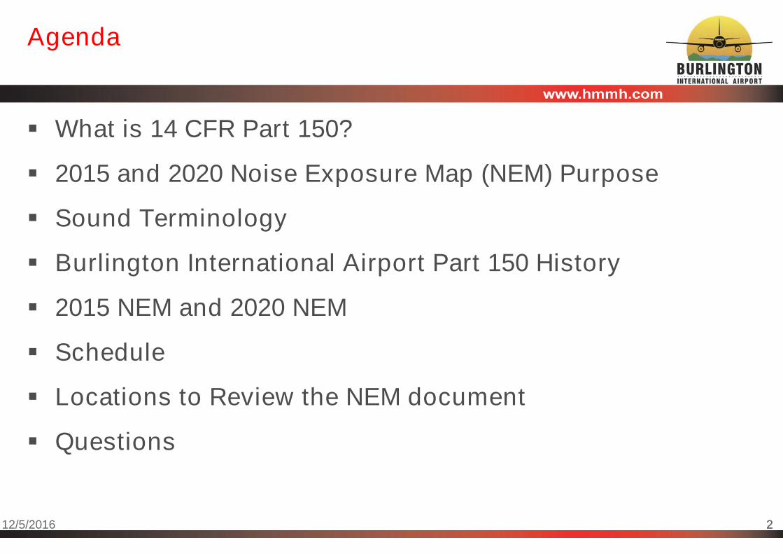
Agenda
What is 14 CFR Part 150?
2015 and 2020 Noise Exposure Map (NEM) Purpose
Sound Terminology
Burlington International Airport Part 150 History
2015 NEM and 2020 NEM
Schedule
Locations to Review the NEM document
Questions

312/5/2016 3
What is “14 C.F.R Part 150” or “Part 150”?“Airport Noise Compatibility Planning”
Title 14 of the Code of Federal Regulations Part 150 (Part150) “Airport Noise Compatibility Planning” sets forthstandards for airport operators to use in documentingnoise exposure around airports and establishing programsto minimize noise-related land use incompatibilities.
Provides airports with technical and procedural guidance
One component of determining eligibility for federal noise abatementfunds
The FAA oversees the Part 150 process on behalf of thefederal government.

412/5/2016 4
What is “14 C.F.R Part 150” or “Part 150”?“Airport Noise Compatibility Planning”
Voluntary FAA-defined process for airport noise studies
Two major components
Noise Exposure Map (NEM) – FAA “accepts”
– Detailed description of airport layout, operations, noise exposure, landuses, and noise/land use compatibility for at least two years
Noise Compatibility Program – FAA “approves” individual measures
– Noise abatement measures to reduce noise exposure
– Land use mitigation measures to address existing non-compatible uses
– Land use control measures to prevent new non-compatible uses
Study completed in 2015 was a Noise Exposure Map update only
Public involvement is a critical consideration
Consultation is required with users and land use control jurisdictions
Input is sought from all interested parties

512/5/2016 5
Burlington International Airport (BTV)2015/2020 Noise Exposure Map (NEM) Purpose
One of the principal reasons for preparation of the2015/2020 update was the City of Burlington’s (as theairport operator) interest in continuing implementation ofthe federally supported noise mitigation strategies.
The City/Airport wanted to update the NEM to reflectexisting operations, an updated forecast, and current landuses.
In addition, the FAA requested that the City/Airport updatethe NEM to continue federally supported noise mitigation.
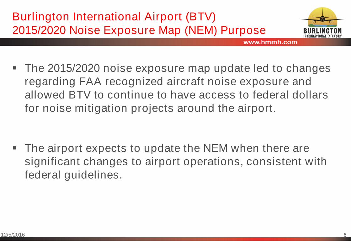
612/5/2016 6
Burlington International Airport (BTV)2015/2020 Noise Exposure Map (NEM) Purpose
The 2015/2020 noise exposure map update led to changesregarding FAA recognized aircraft noise exposure andallowed BTV to continue to have access to federal dollarsfor noise mitigation projects around the airport.
The airport expects to update the NEM when there aresignificant changes to airport operations, consistent withfederal guidelines.

712/5/2016 7
Sound Terminology
A-weighted decibel (dBA) Reflects the manner humans hear
different pitches of sound
All federal agencies have adopted dBAfor environmental studies
dBA can be used for different units ofmeasure, like maximum and average
Day–Night Average Sound Level (DNLor Ldn) Cumulative sound measure
Equal to steady level that contains sameenergy as the actual time-varying sound
Increases sounds from 10 p.m. to 7 a.m.10-fold
Used by all federal agencies that dealwith aviation noise
812/5/2016 8
Burlington International Airport (BTV)Part 150 History
FAA accepted NEM for 1989 and 1993 conditions in March 1990
FAA approved NCP in July 1990
FAA accepted NEM update (for 1997 and 2002) in June 1997
FAA accepted NEM update (for 2006 and 2011) in November2006
FAA approved NCP revision in June 2008
This has been one of the BTV documents and FAA approvals that hasallowed the airport to continue acquisitions
FAA accepted NEM update (for 2015 and 2020) in December2015
The Nov. 9, 2015 meeting presented the draft 2015/2020 NEMs andstarted the public comment period, before submittal to the FAA
912/5/2016 9
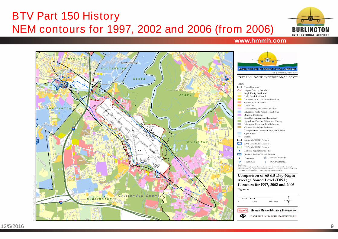
BTV Part 150 HistoryNEM contours for 1997, 2002 and 2006 (from 2006)

1012/5/2016 10
BTV Part 150 HistoryNEM contours for 2006 and 2011

1112/5/2016 11
2015 NEM and 2020 NEMAssumptions and Data
Existing conditions are the year of submittal 2015 (perregulation)
Based on data collected from 2012 through 2014
F-16 operations modeled with data provided by the USAF using anFAA approved method
– Adjusted for Part 150 regulatory requirements
- USAF data for BTV use 228 operational days
- NEM assumes 365 operational days (per FAA regulations)
- Both the NEM and the USAF data reflect same number of F-16 annualoperations (8,099);
- “typical year” of operations, as opposed to the VTANG summer 2015deployment
– FAA approved method included a combination of USAF and FAA noisemodels
1212/5/2016 12
2015 NEM and 2020 NEMAssumptions and Data
Forecast conditions are 2020
Regulations require a forecast representing 5 or more years
Includes expected Taxiway G (southeast side of airfield)
Continued F-16 operations at constant levels
Note related to 2020 NEM forecast
The airport expects to update the NEM when there are significantchanges to airport operations, consistent with federal guidelines

1312/5/2016 13
2015 NEM and 2020 NEMAssumptions and Data
Land use data
Provided by Chittenden County Regional Planning Commission
– Updated based on aerial photography, airport staff data and variousinternet searches
Maps display land use, color coded by the categories noted in theFAA regulation
Dwelling inventories were prepared to the parcel/dwelling level.
Population per dwelling estimated by U.S. Census data.
1412/5/2016 14
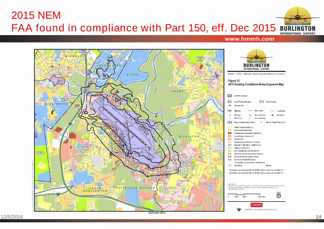
2015 NEMFAA found in compliance with Part 150, eff. Dec 2015

1512/5/2016 15
2015 NEM Land Use Analysis Summaryas Documented in December 2015 NEM Submission
Residential dwellings and population within the 2015 65 dBDNL noise contours
622 Single family houses
354 Multi-family units (individual apartments/condominium units)
2,267 estimated population
In addition: St. Michael's College: 3 dormitories; approx. 264student residents
List of non-residential noise sensitive locations
6 education facilities
– Only public is Chamberlain Elementary School
8 places of worship (3 churches, 5 cemeteries)
1 Public gathering place

1612/5/2016 16
2015 NEM Land Use Analysis Summaryas Documented in December 2015 NEM Submission
City of South Burlington
Estimated dwelling units within 65 dB or greater DNL: 948
– 663 dwelling units are south of the airport and west of Kennedy Dr.
- Some of these have been acquired since the 2015 NEM
– 38 dwelling units are south of the airport and east of Kennedy Dr.
– 247 dwelling units are north of the airport
Town of Williston
None, although there are two parcels zoned as residential
1712/5/2016 17
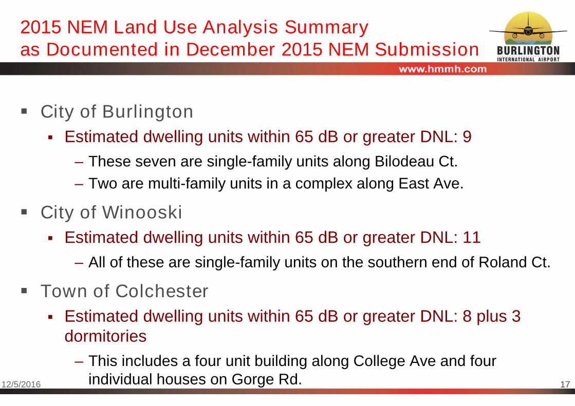
2015 NEM Land Use Analysis Summaryas Documented in December 2015 NEM Submission
City of Burlington
Estimated dwelling units within 65 dB or greater DNL: 9
– These seven are single-family units along Bilodeau Ct.
– Two are multi-family units in a complex along East Ave.
City of Winooski
Estimated dwelling units within 65 dB or greater DNL: 11
– All of these are single-family units on the southern end of Roland Ct.
Town of Colchester
Estimated dwelling units within 65 dB or greater DNL: 8 plus 3dormitories
– This includes a four unit building along College Ave and fourindividual houses on Gorge Rd.

1812/5/2016 18
2020 NEMFAA found in compliance with Part 150, eff. Dec 2015

1912/5/2016 19
2020 NEM Land Use Analysis Summaryas Documented in December 2015 NEM Submission
Residential dwellings and population within the 2020 65 dBDNL noise contours
618 Single family houses
354 Multi-family (individual apartments/condominium units)
– Same as 2015 NEM
2,258 estimated population
In addition: St. Michael's College: 2 dormitories; approx. 136student residents
List of non-residential noise sensitive locations
Same as 2015 NEM

2012/5/2016 20
2015 NEM and 2020 NEMEnlargements Available

2112/5/2016 21
2015 NEMComparison to various contours 2006-2015
2015 NEM compared to prior 2006/2011 NEM contours
Wider contours perpendicular to the runway
– Includes some residential areas in Colchester for the first time
Shorter contours parallel to the runway compared to the 2006 and2011 Noise Exposure Map
– Less overlap in Winooski and Williston
2015 NEM compared to USAF’s most recent noisecontours that represent existing F-16 operations
Both existing F-16 operations
NEM not as wide EIS existing/baseline conditions
Primary difference is the use of USAF 228 days versus FAA’s365 days

2212/5/2016 22
2015 NEMComparison to various contours 2006-2015
2312/5/2016 23
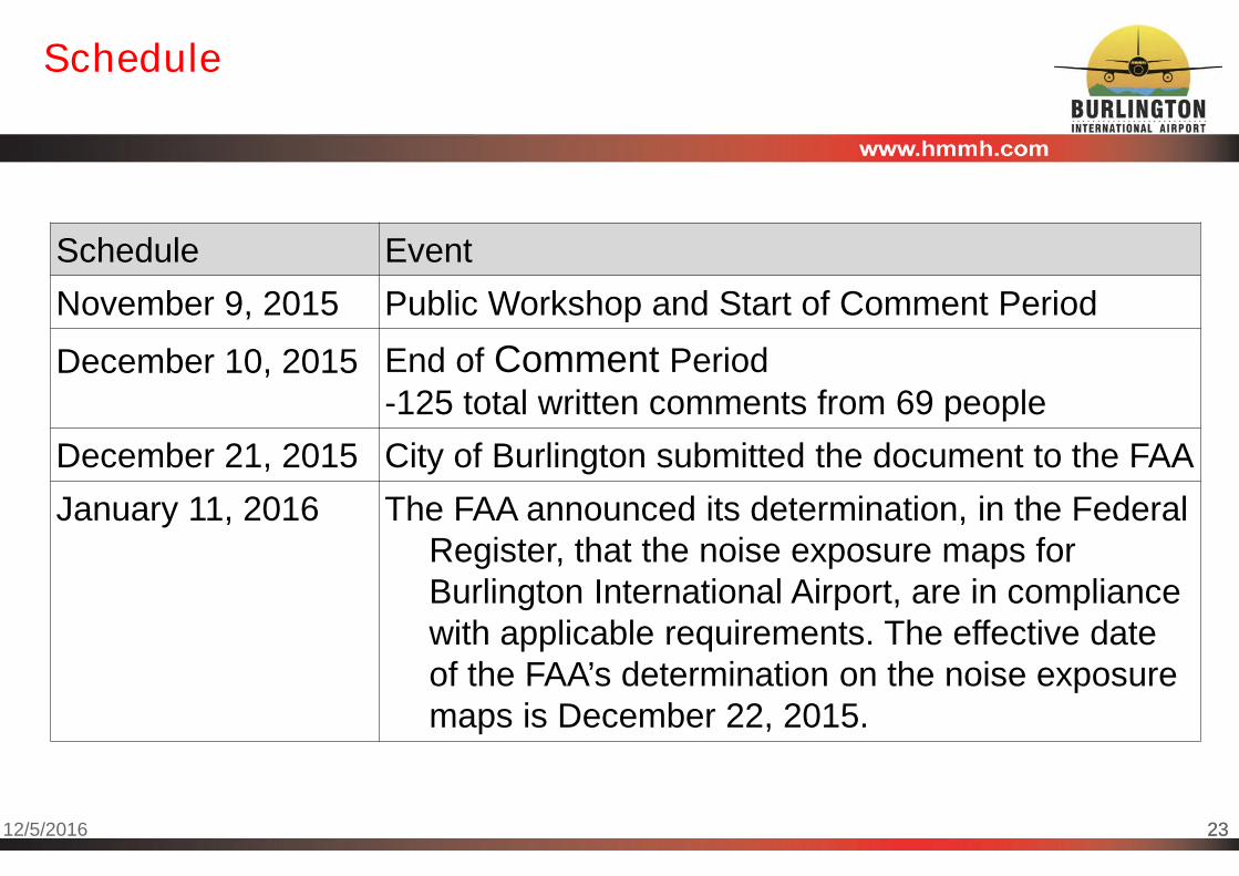
Schedule
Schedule Event
November 9, 2015 Public Workshop and Start of Comment Period
December 10, 2015 End of Comment Period-125 total written comments from 69 people
December 21, 2015 City of Burlington submitted the document to the FAA
January 11, 2016 The FAA announced its determination, in the FederalRegister, that the noise exposure maps forBurlington International Airport, are in compliancewith applicable requirements. The effective dateof the FAA’s determination on the noise exposuremaps is December 22, 2015.

2412/5/2016 24
Locations to Review the NEM document
Hardcopies, are available for reviewduring business hours at
The airport offices
Electronic, available at
The airport’s website
Thank you for attending!