
Bureau of Land Management (BLM) handbook provides the Bureau of Land Management (BLM)’s standard...
39
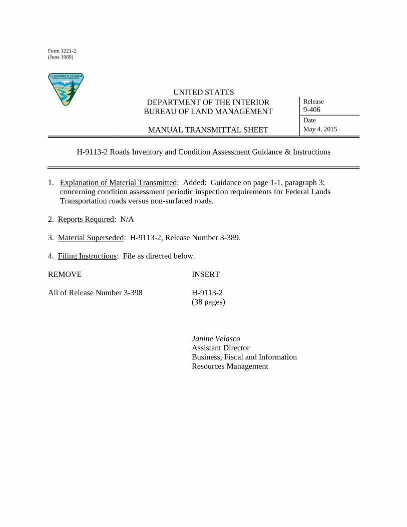
Form 1221-2 (June 1969) UNITED STATES DEPARTMENT OF THE INTERIOR BUREAU OF LAND MANAGEMENT MANUAL TRANSMITTAL SHEET Release 9-406 Date May 4, 2015 H-9113-2 Roads Inventory and Condition Assessment Guidance & Instructions 1. Explanation of Material Transmitted: Added: Guidance on page 1-1, paragraph 3; concerning condition assessment periodic inspection requirements for Federal Lands Transportation roads versus non-surfaced roads. 2. Reports Required: N/A 3. Material Superseded: H-9113-2, Release Number 3-389. 4. Filing Instructions: File as directed below. REMOVE INSERT All of Release Number 3-398 H-9113-2 (38 pages) Janine Velasco Assistant Director Business, Fiscal and Information Resources Management
Transcript of Bureau of Land Management (BLM) handbook provides the Bureau of Land Management (BLM)’s standard...
Form 1221-2
(June 1969)
UNITED STATES
DEPARTMENT OF THE INTERIOR
BUREAU OF LAND MANAGEMENT
MANUAL TRANSMITTAL SHEET
Release
9-406
Date
May 4, 2015
H-9113-2 Roads Inventory and Condition Assessment Guidance & Instructions
1. Explanation of Material Transmitted: Added: Guidance on page 1-1, paragraph 3;
concerning condition assessment periodic inspection requirements for Federal Lands
Transportation roads versus non-surfaced roads.
2. Reports Required: N/A
3. Material Superseded: H-9113-2, Release Number 3-389.
4. Filing Instructions: File as directed below.
REMOVE INSERT
All of Release Number 3-398 H-9113-2
(38 pages)
Janine Velasco
Assistant Director
Business, Fiscal and Information
Resources Management

H-9113-2 ROADS NATIONAL INVENTORY AND CONDITION ASSESSMENT GUIDANCE
& INSTRUCTIONS HANDBOOK (PUBLIC)
i
BLM Handbook Rel. No. 9-406
Supersedes Rel. No. 9-389 05/04/2015
Table of Contents
1.1 Introduction ............................................................................................................................... 1-1
1.2 Background ............................................................................................................................... 1-1
1.3 Process. ....................................................................................................................................... 1-2
1.4 Inspector Qualifications. .......................................................................................................... 1-2
1.5 Project Phases............................................................................................................................ 1-3
1.6 Conducting an Inventory & Condition Assessment for BLM Roads. ................................. 1-3 A. Phase I - Inventory and Assessment Planning. ........................................................................... 1-4
1. General .................................................................................................................................... 1-4
2. Specific Tasks ......................................................................................................................... 1-5
3. Summary ................................................................................................................................. 1-6
B. Phase II - On-Site Data Collection.............................................................................................. 1-6
1. General. ................................................................................................................................... 1-6
2. Specific Tasks ......................................................................................................................... 1-6
3. On-Site Data Collection Tools ................................................................................................ 1-7
4. Road Designation, Location, and Name ................................................................................. 1-8
5. Road Segmentation ................................................................................................................. 1-8
6. On-Site Measurements for Inventory.................................................................................... 1-10
7. On-Site Measurement for Deferred Maintenance ................................................................. 1-10
8. On-Site Inspection Protocols ................................................................................................ 1-12
9. Field Assessment Checklist .................................................................................................. 1-29
10. Summary ............................................................................................................................... 1-29
C. Phase III – In-Office Data Entry ............................................................................................... 1-30
1. General .................................................................................................................................. 1-30
2. Specific Tasks ....................................................................................................................... 1-30
3. Summary – Phase III – In-Office Data Entry ....................................................................... 1-31
D. Phase IV Data Quality Assurance and Review ......................................................................... 1-31
1. General .................................................................................................................................. 1-31
2. Specific Tasks ....................................................................................................................... 1-31
3. Summary ............................................................................................................................... 1-32
APPENDIX A – ROAD CONDITION ASSESSMENT FORM ............................................................. A-1
APPENDIX B – GUIDANCE ON TERRAIN TYPES ............................................................................ B-1

H-9113-2 ROADS NATIONAL INVENTORY AND CONDITION ASSESSMENT GUIDANCE
& INSTRUCTIONS HANDBOOK (PUBLIC)
1-1
BLM Handbook Rel. No. 9-406
Supersedes Rel. No. 9-389 05/04/2015
Chapter 1 - Overview
1.1 Introduction
This handbook provides the Bureau of Land Management (BLM)’s standard process for the inventory and
condition assessment of BLM roads as defined in Manual Section 9100 – Facilities Planning, Design,
Construction, and Maintenance.
All BLM roads are required to complete a baseline comprehensive condition assessment that includes
Geographical Information System (GIS) spatial data as well as BLM asset management system inventory
and condition assessment information tabular data. Roads are excluded that have been identified by each
state not to be condition assessed based on the following reasons:
Physically inaccessible
Not a BLM road
Environmental Hazard
Isolated and extremely remote
Roads in storage (Western Oregon)
Condition assessment problems, noted and transmitted to BLM COTR.
BLM surfaced roads (aggregate, paved, etc.) should be re-inspected on a regular interval (not to exceed 10
years) in accordance with the BLM’s overall asset management program, utilizing the provided
methodology (GIS spatial information is generally not collected during re-inspections unless a specific
need for updated information has been identified). Non-surfaced roads are inspected as needed on a local
basis, or after events such as severe storms, or on a discovery basis. All Bureau roads that have been
included in the Federal Lands Transportation (FLT) designated network are to be inspected on a five year
cycle.
New roads entering the BLM asset management system are also required to complete the inventory and
assessment process prior to their entry into the BLM asset management system.
1.2 Background
The BLM is required to annually report the inventory and physical condition of its transportation
infrastructure systems.
Consistency and integrity of information and process is essential to the BLM’s ability to accomplish that
objective and be directly linked to the effectiveness of the BLM’s asset management program.
In order to provide a reasonable, consistent, and auditable process, BLM must:
1. Create a maintainable inventory of roads.
2. Support a condition assessment program that determines road condition and needs.
3. Develop reasonable cost estimates to correct any deferred maintenance deficiencies.
4. Work uniformly and consistently across the BLM road inventory.
5. Provide a cost effective auditable approach to managing BLM roads.
H-9113-2 ROADS NATIONAL INVENTORY AND CONDITION ASSESSMENT GUIDANCE
& INSTRUCTIONS HANDBOOK (PUBLIC)
1-2
BLM Handbook Rel. No. 9-406
Supersedes Rel. No. 9-389 05/04/2015
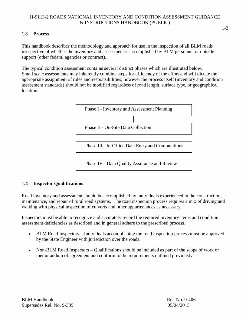
1.3 Process
This handbook describes the methodology and approach for use in the inspection of all BLM roads
irrespective of whether the inventory and assessment is accomplished by BLM personnel or outside
support (other federal agencies or contract).
The typical condition assessment contains several distinct phases which are illustrated below.
Small scale assessments may inherently combine steps for efficiency of the effort and will dictate the
appropriate assignment of roles and responsibilities, however the process itself (inventory and condition
assessment standards) should not be modified regardless of road length, surface type, or geographical
location.
1.4 Inspector Qualifications
Road inventory and assessment should be accomplished by individuals experienced in the construction,
maintenance, and repair of rural road systems. The road inspection process requires a mix of driving and
walking with physical inspection of culverts and other appurtenances as necessary.
Inspectors must be able to recognize and accurately record the required inventory items and condition
assessment deficiencies as described and in general adhere to the prescribed process.
BLM Road Inspectors – Individuals accomplishing the road inspection process must be approved
by the State Engineer with jurisdiction over the roads.
Non-BLM Road Inspectors – Qualifications should be included as part of the scope of work or
memorandum of agreement and conform to the requirements outlined previously.
Phase I - Inventory and Assessment Planning
Phase II - On-Site Data Collection
Phase III - In-Office Data Entry and Computations
Phase IV - Data Quality Assurance and Review
H-9113-2 ROADS NATIONAL INVENTORY AND CONDITION ASSESSMENT GUIDANCE
& INSTRUCTIONS HANDBOOK (PUBLIC)
1-3
BLM Handbook Rel. No. 9-406
Supersedes Rel. No. 9-389 05/04/2015
1.5 Project Phases
The typical road assessment project contains several distinct project phases. Individual phases may be
accomplished by the same individual or by a team of personnel depending on the scale and complexity of
the assessment effort.
Phase I – Inventory and Assessment Planning - The planning phase consists of data gathering and
schedule coordination. An Assessment Leader will work with the BLM State Engineer and Field
Office personnel to collect mapping, begin/end points of road segments, land ownership change
locations, segment change locations, and other pertinent information on each road segment to be
inventoried and assessed. The Assessment Leader will transfer the collected data to the Field
Assessment Personnel. The Assessment Leader will also provide scheduling coordination for
assessment personnel and BLM Field Office staff. The Assessment Leader is responsible for
determining the need for special tools or equipment required by the Field Assessment Personnel to
carry out the work in the field.
Phase II - On-Site Data Collection - On-site data collection will be accomplished by approved
personnel. They will traverse all the roads identified for inventory and assessment and accomplish
the required data collection and condition assessment. It is desirable to have a BLM Field Office
staff member accompany assessment personnel whenever possible.
Phase III - In-Office Data Entry and Computations - Data collected on-site will be downloaded at
the designated office location for data cleansing and computations. GIS spatial data will be
validated and updated to BLM data standards. Previously developed deferred maintenance unit
costs and current replacement value unit costs will be applied to deficiencies observed and road
segments inventoried.
Phase IV - Data Quality Review - Completed inventory and condition assessment information will
be independently reviewed in the office for conformance with BLM requirements. Spatial data,
tabular data, photos, and required supporting documentation should all be reviewed as an
integrated package prior to delivery to the BLM.
Delivery of Data to BLM - Completed inventory and condition assessment information will be
provided to the BLM in electronic format for validation by the BLM and entry into the BLM’s
asset management system.
1.6 Conducting an Inventory & Condition Assessment for BLM Roads
This section provides detailed guidance for the completion of each of the four project phases associated
with completing an inventory and condition assessment for BLM roads.
The official inventory of roads resides within the BLM asset management system and each road has a
unique identifier within that system. Roads and road segments are named by the BLM States and naming
conventions vary across the system.
H-9113-2 ROADS NATIONAL INVENTORY AND CONDITION ASSESSMENT GUIDANCE
& INSTRUCTIONS HANDBOOK (PUBLIC)
1-4
BLM Handbook Rel. No. 9-406
Supersedes Rel. No. 9-389 05/04/2015
BLM roads are comprised of road segments which are continuous sections of road with consistent surface
type, dimension, jurisdiction, maintenance intensity, and general construction standards conforming to the
BLM standard definition of a road (reference Manual Section 9100 – Facility Planning, Design,
Construction, and Maintenance).
BLM road inventory and condition assessments are accomplished at the road segment. Each road segment
is tracked, inventoried and assessed individually within the BLM asset management system.
A. Phase I - Inventory and Assessment Planning
The inventory and assessment planning phase validates the current road inventory contained within the
BLM asset management system and establishes the work plan for on-site data collection.
1. General
The Assessment Leader will prepare a field assessment schedule identifying all the roads
planned for inventory and assessment and provide it to the designated BLM contact in advance
of beginning on-site data collection (Field Work).
The Assessment Leader will gather all available information concerning the roads to be
assessed, such as road maps, begin/end points, land ownership information, previous
assessments, and spatial data. Base information including road segment name, unique
identifier, maintenance information, surface type, and road limits will be downloaded from
BLM’s asset management system and provided to the assessment team as part of the planning
package.
Road segmentation, categorization, asset class, and related inventory decisions should be made
by the BLM Field Office prior to the inspection process to maximize the efficiency of the on-
site data collection.
Corrections to the road inventory should be completed by authorized BLM personnel within
the BLM asset management system to maintain consistency between the inventory, condition
assessment process and baseline data.
Roads that are extremely distant or remote from the Field Office should be reviewed with BLM
personnel to determine the viability of inclusion into the assessment effort. In general, all
asphalt surfaced roads should be assessed regardless of distance. Aggregate and naturally
surfaced roads should be assessed if they are less than one hour drive time from adjacent roads
identified for assessment. A list of roads (and their associated road segments) recommended
for exclusion due to remoteness should be forwarded to the State Engineer for approval at the
conclusion of the planning process. Road segments recommended for exclusion should not
exceed 5 percent of the total road inventory (based on lane miles).
Roads in storage status as defined in the Bureau’s asset management system are not currently
open, operated, or maintained, but may be reopened at a future date. Storage roads are not
required to have Comprehensive Condition Assessments until they are placed in an operational

H-9113-2 ROADS NATIONAL INVENTORY AND CONDITION ASSESSMENT GUIDANCE
& INSTRUCTIONS HANDBOOK (PUBLIC)
1-5
BLM Handbook Rel. No. 9-406
Supersedes Rel. No. 9-389 05/04/2015
status and maintained. Storage status should not be used for seasonally closed roads, which
would remain open in operating statue through their normal seasonal closures.
BLM State or Field Offices may have existing GIS (spatial) information that conforms to BLM
requirements. If existing data is available, it may be utilized in lieu of collecting new GIS data
with the prior approval of the State Engineer and BLM National Data Steward.
The Assessment Leader will coordinate with local BLM staff to determine if special equipment
or procedures are required by assessment personnel for work in that area. A safety briefing for
assessment personnel will also be scheduled prior to conducting the field assessment. Safety
briefings will be reviewed and documented.
2. Specific Tasks
The Assessment Leader will complete the following tasks prior to commencing on-site data
collection:
i. Obtain a current inventory of all roads to be inspected from the BLM asset
management system (typically conducted on a Field Office basis).
ii. Schedule a roads inventory and condition assessment planning session with the
assigned local BLM Point of Contact (POC).
iii. Provide the local BLM POC a list of requested information (maps, maintenance
information, access issues, previous inspections, construction projects, seasonal
concerns, jurisdictional issues, availability of GIS data, etc) for assembly prior to
scheduled planning session.
iv. Meet with the local BLM POC to develop the work-plan for the identified roads.
Update inventory as necessary to reflect field conditions
Establish seasonal issues and a safety plan
Review existing roads information
Validate compliance of selected roads to BLM Manual Section 9113 – Roads.
Identify roads that may be considered remote, inaccessible, or placed in storage
status and evaluate the feasibility of assessment. If roads are recommended for
exclusion, summarize and provide the recommendation to the State Engineer for
concurrence. (In general, roads recommended for exclusion should not exceed
five percent of the total lane miles.)
Determine road segmentation requirements if current road segments are not
consistent in their basic definition (road, primitive road, trail), surface type,
jurisdiction, maintenance intensity, or general construction and segment in
accordance with BLM guidance.
Develop a recommended work-plan/field schedule for the inspection process.
Document rationale/decisions that influence work flow or any determination to
forgo inventory and condition assessment of a particular road.
Develop a safety plan and determine if special equipment is required.
v. Obtain concurrence from the local BLM POC on the work-plan.

H-9113-2 ROADS NATIONAL INVENTORY AND CONDITION ASSESSMENT GUIDANCE
& INSTRUCTIONS HANDBOOK (PUBLIC)
1-6
BLM Handbook Rel. No. 9-406
Supersedes Rel. No. 9-389 05/04/2015
vi. Provide the work-plan to assessment personnel.
3. Summary
Phase I: Inventory and Assessment Planning. In summary, the following tasks will be
performed in the office by the Assessment Leader, with assistance from BLM staff, to prepare
for on-site (field) data collection:
Prepare field schedule.
Collect road maps and other pertinent data.
Prepare a listing of road and road segment information (unique id, name, surface type,
location, map coordinates, etc).
Prepare a listing of road and road segments recommended for exclusion and obtain
approval from the State Engineer (unique id, name, surface type, location, map
coordinates, etc.).
Determine road segmentation updates (begin/end points, land ownership and surface
type changes).
Determine if special equipment is required.
Schedule safety briefing.
Document work plan decisions and rationale for assessment personnel.
B. Phase II - On-Site Data Collection
The on-site data collection phase implements the inventory and assessment work-plan to complete the
field portion of the roads assessment program. It requires assessment personnel to conduct a field
visual assessment (FVA) of all the road segments within the work-plan.
1. General
On-Site data collection may be accomplished by BLM personnel, other agencies, or contractor
personnel as long as it is completed in accordance with standard BLM methodology and practice. On-
Site data collection is generally accomplished from a vehicle driven across all accessible road
segments by the assessment personnel using the work-plan developed in Phase I – Inventory and
Assessment Planning.
2. Specific Tasks
Assessment personnel will complete the following tasks as part of the site data collection Phase.
i. Review work-plan from Phase I.
ii. Contact local BLM POC and schedule on-site data collection event(s).

H-9113-2 ROADS NATIONAL INVENTORY AND CONDITION ASSESSMENT GUIDANCE
& INSTRUCTIONS HANDBOOK (PUBLIC)
1-7
BLM Handbook Rel. No. 9-406
Supersedes Rel. No. 9-389 05/04/2015
iii. Complete logistics for assessment personnel (transportation, lodging, etc).
iv. Prepare work data. See paragraph C – On-Site Data Collection Tools.
v. Prepare Tool List (typical tool list provided below).
vi. Mobilize at the Local Field Office.
vii. In-Brief with Local BLM POC.
viii. Execute Work-Plan by completing inventory and condition assessment for identified roads.
a. Existing/Re-inspections - Collect GIS (spatial), inventory, and condition assessment
(tabular) information for all Baseline Comprehensive Condition Assessments on each
Road Segment (unless GIS data has already been completed and validated).
b. Collect inventory and condition assessment information for all comprehensive re-
inspections on each Road Segment.
c. New/Baseline - Collect GIS (spatial), Inventory, and condition assessment (tabular)
information for all Baseline Comprehensive Condition Assessments on new Road
Segments (unless GIS data has already been completed and validated).
d. Document deviations from the established work-plan including rationale and
modification.
e. Document additional segmentation requirements based on segmentation guidance. See
paragraph E. Road Segmentation.
f. Upload/transfer data to the office in accordance with the work-plan.
g. Follow established access, safety, and communication plan.
ix. At the conclusion of the work-plan, meet with local BLM POC and conduct an Out-Brief
3. On-Site Data Collection Tools
The list below is provided as a general reference for assessment personnel. Specific tools
necessary for the inventory and condition assessment of roads in a specific location will be
included as part of the work-plan.
Clipboard and notepaper
Computer and accessories such as spare batteries and power charger
Digital camera and accessories
GPS Device meeting current BLM data requirements
25’ measuring tape
H-9113-2 ROADS NATIONAL INVENTORY AND CONDITION ASSESSMENT GUIDANCE
& INSTRUCTIONS HANDBOOK (PUBLIC)
1-8
BLM Handbook Rel. No. 9-406
Supersedes Rel. No. 9-389 05/04/2015
Rock hammer
Safety equipment (fire extinguisher, flares, reflective vests, first aid kit)
4. Road Designation, Location, and Name
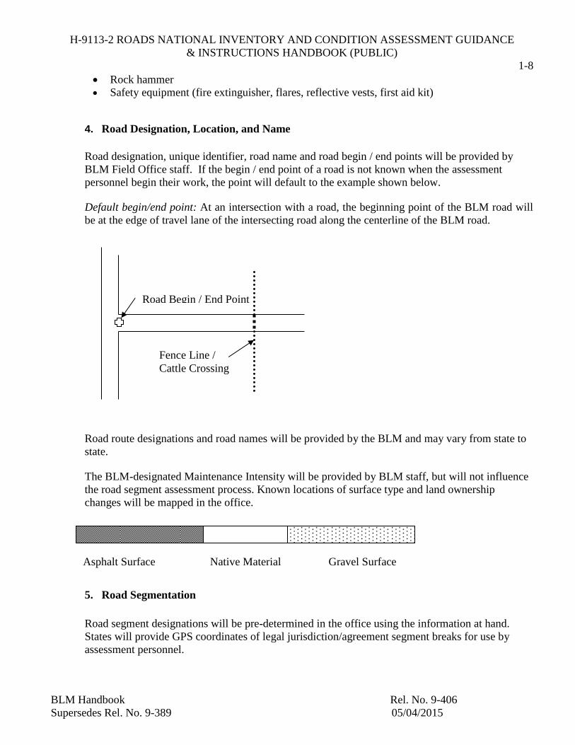
Road designation, unique identifier, road name and road begin / end points will be provided by
BLM Field Office staff. If the begin / end point of a road is not known when the assessment
personnel begin their work, the point will default to the example shown below.
Default begin/end point: At an intersection with a road, the beginning point of the BLM road will
be at the edge of travel lane of the intersecting road along the centerline of the BLM road.
Road route designations and road names will be provided by the BLM and may vary from state to
state.
The BLM-designated Maintenance Intensity will be provided by BLM staff, but will not influence
the road segment assessment process. Known locations of surface type and land ownership
changes will be mapped in the office.
5. Road Segmentation
Road segment designations will be pre-determined in the office using the information at hand.
States will provide GPS coordinates of legal jurisdiction/agreement segment breaks for use by
assessment personnel.
Road Begin / End Point
Fence Line /
Cattle Crossing
Asphalt Surface Native Material Gravel Surface

H-9113-2 ROADS NATIONAL INVENTORY AND CONDITION ASSESSMENT GUIDANCE
& INSTRUCTIONS HANDBOOK (PUBLIC)
1-9
BLM Handbook Rel. No. 9-406
Supersedes Rel. No. 9-389 05/04/2015
Road segments must be homogeneous in nature. Therefore, a change in road surface type, or width
of lanes (one-lane ≤ 15’, two-lanes > 15’ in width) will signal a change in road segment. The
previous example road will have three segments as shown below. If a gravel road segment has an
asphalt apron at its intersection with an asphalt road, it will still be considered one segment, and
not divided into two segments.
On unpaved road surfaces, short portions of the road may vary in width for pull-out areas, wide
turns/curves, intersections, cattle guard gates, and turn-around areas. The width change of a road
must be greater than four feet and continue for a minimum distance of 1/10th
mile for a segment
change to occur.
Road segments will begin/end when private property, state land, or any non-BLM land is
encountered as shown in the following diagram unless the BLM has easement or jurisdiction of the
road. If assessment personnel are uncertain about jurisdiction, they should note the location of the
questionable segment in the data file with a GPS point and a comment note and continue assessing
the road portion as a single segment.
If a road is barricaded, the assessment personnel will make every effort possible to reach the road
from the other side of the property in order to complete the road segment inventory and
assessment. Some roads may not connect, leaving the remaining segment inaccessible.
Inaccessible roads should be noted with a GPS comment before proceeding on to the next road
segment.
Segment 1 Segment 2
Material
Segment 3
Private
Property
BLM
Property
Gate or Barrier
or Sign
End Segment 1
(GPS point)
Begin Segment 2
(GPS point)
BLM
Property

H-9113-2 ROADS NATIONAL INVENTORY AND CONDITION ASSESSMENT GUIDANCE
& INSTRUCTIONS HANDBOOK (PUBLIC)
1-10
BLM Handbook Rel. No. 9-406
Supersedes Rel. No. 9-389 05/04/2015
6. On-Site Measurements for Inventory
Assessment personnel are required to perform seven basic tasks during the course of the on-site
inventory data collection:
i. Validate surface type and width for each road segment designation. All data will be based
on a coordinate system, not road mile markers. However, if a GPS unit is not available,
note mile markers.
ii. Note predominate terrain type (flat, rolling, or mountainous).
iii. Note if the road segment should be considered a “primitive road” based on Manual Section
9100 – Facility Planning, Design, Construction, and Planning).
iv. GPS road centerline at specified interval (interval not to exceed 25 feet).
v. GPS locations of potential segmentation changes based on surface type and width changes.
vi. Take digital photos of typical road.
a. Begin/end of road (note: end photo looking back onto road).
b. Potential health and safety items.
vii. Identify and GPS potential health and safety items and location.
Photos will be taken in landscape view and developed in .jpeg format. The photo number given by
the digital camera will be recorded into the photo number field in the inventory database.
Potential health and safety deferred maintenance items are those that may pose a serious threat to
public or BLM employee health and safety. Potential health and safety items include such things as
road washouts, damaged guardrail, falling rocks and collapsed culverts. Potential health and safety
events are not always points – they may be noted as lengths or areas. All potential health and
safety items will be inventoried so that BLM officials can locate the item.
7. On-Site Measurement for Deferred Maintenance
Assessment personnel will identify and quantify deferred maintenance on all road segments as well
as appurtenances located along the road segment (cattle guards, signage, rails, etc.) in accordance
with the BLM standard included in this Manual Section.
Each road segment will be assessed for deferred maintenance items. Deferred maintenance is
defined as maintenance that was not performed when it should have been or was scheduled to be
and which is put off or delayed for a future period. Deferred maintenance includes items such as
culvert cleanout and repair, aggregate replacement, and medium to severe potholes and ruts.
H-9113-2 ROADS NATIONAL INVENTORY AND CONDITION ASSESSMENT GUIDANCE
& INSTRUCTIONS HANDBOOK (PUBLIC)
1-11
BLM Handbook Rel. No. 9-406
Supersedes Rel. No. 9-389 05/04/2015
Deferred maintenance does not include items that were not originally constructed (e.g., if ditches
were not originally constructed for the road segment, they can not become a deferred maintenance
item).
Annual maintenance is defined as the maintenance tasks accomplished on a regular basis to keep
assets in acceptable condition. Grading of low-severity ruts, minor culvert maintenance, potholes
and roadside brushing of light vegetation are examples of annual maintenance and are not to be
recorded as deferred maintenance.
Likewise, component renewal items, such as programmed overlays, are not considered deferred
maintenance unless the condition of the road is not currently acceptable and an overlay is needed
immediately.
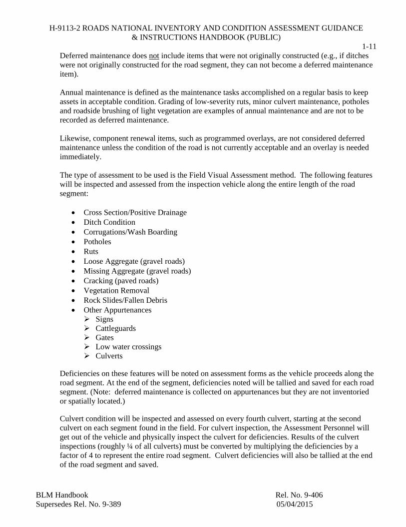
The type of assessment to be used is the Field Visual Assessment method. The following features
will be inspected and assessed from the inspection vehicle along the entire length of the road
segment:
Cross Section/Positive Drainage
Ditch Condition
Corrugations/Wash Boarding
Potholes
Ruts
Loose Aggregate (gravel roads)
Missing Aggregate (gravel roads)
Cracking (paved roads)
Vegetation Removal
Rock Slides/Fallen Debris
Other Appurtenances
Signs
Cattleguards
Gates
Low water crossings
Culverts
Deficiencies on these features will be noted on assessment forms as the vehicle proceeds along the
road segment. At the end of the segment, deficiencies noted will be tallied and saved for each road
segment. (Note: deferred maintenance is collected on appurtenances but they are not inventoried
or spatially located.)
Culvert condition will be inspected and assessed on every fourth culvert, starting at the second
culvert on each segment found in the field. For culvert inspection, the Assessment Personnel will
get out of the vehicle and physically inspect the culvert for deficiencies. Results of the culvert
inspections (roughly ¼ of all culverts) must be converted by multiplying the deficiencies by a
factor of 4 to represent the entire road segment. Culvert deficiencies will also be tallied at the end
of the road segment and saved.

H-9113-2 ROADS NATIONAL INVENTORY AND CONDITION ASSESSMENT GUIDANCE
& INSTRUCTIONS HANDBOOK (PUBLIC)
1-12
BLM Handbook Rel. No. 9-406
Supersedes Rel. No. 9-389 05/04/2015
8. On-Site Inspection Protocols
The method of estimating and recording each of the deficiencies is discussed on the following
pages. Each deficiency will also be assigned a severity level of medium or high. (Low-severity
indicates annual maintenance needs). Different severity levels may exist within the same segment
resulting in multiple entries of a single deficiency. The severity level is based on the perception of
the field inspector while driving the road segment. For example, a pothole will be rated as medium
or high severity based on the inspector’s view from the vehicle – the inspector will not physically
measure the depth of the pot hole to determine its severity.
Linear estimations for cross section, ditch, corrugations, ruts, vegetation removal, loose or missing
aggregate, and cracking will be made from the inspection vehicle rather than physically measuring
the deficiency with a tape measure. A quick reference guide has been provided at the end of this
section.
a. Cross Section/Positive Drainage
BLM roads may have three types of drainage: Longitudinal drainage (water drains in the direction
of the road), cross slope drainage (water is drained across the road surface) and crowned road
drainage (roads that have a crown where water drains from the center to the road edge).
Assessment of cross section will be made by noting if there is positive drainage for the road
surface. Corrective actions for improper cross section will be either grading of high areas or filling
of low areas. A cross section deficiency will be noted in the field as an estimate of the length,
width and depth of the area to be graded or filled.
b. Ditch Condition
Poor drainage due to an inadequate ditch section may cause water to pond and weaken the road bed. Ditch
deficiency is estimated in linear feet parallel to the centerline of the road. The maximum length of ditch
Positive Cross slope
Positive Cross slope
Crowned Cross section
Longitudinal drainage

H-9113-2 ROADS NATIONAL INVENTORY AND CONDITION ASSESSMENT GUIDANCE
& INSTRUCTIONS HANDBOOK (PUBLIC)
1-13
BLM Handbook Rel. No. 9-406
Supersedes Rel. No. 9-389 05/04/2015
condition deficiency is two times the length of the road segment. Low severity drainage distress is
characterized by evidence of ponding water in the ditches and overgrowth or debris in the ditches. Low
severity is considered annual maintenance and will not be assessed as a deficiency. Medium severity
includes low severity conditions plus erosion of the ditches into the edge of the road. Medium severity
will be calculated as deferred maintenance. At the highest severity, ditch deficiency includes evidence of
ponding water, water running across the road, overgrowth or debris in the ditches and severe erosion of
the ditches into the road surface.
Existing ditches will be assessed for deferred maintenance/cleaning even if it is evident that the ditch does
not outlet anywhere or have positive drainage (i.e. would quickly silt back in). If a ditch was “built” and is
half full, it will have deferred maintenance assigned. Deferred maintenance will be assigned even if it is
evident that the ditch was filled in by improper road maintenance grading. A ditch may also have erosion
problems and require fill material. Inspectors will note the severity of the condition as well as the length,
width and depth of ditch cleaning or fill.
(Source: USACE Technical Manual 5-626)
Excessive erosion of the ditch

H-9113-2 ROADS NATIONAL INVENTORY AND CONDITION ASSESSMENT GUIDANCE
& INSTRUCTIONS HANDBOOK (PUBLIC)
1-14
BLM Handbook Rel. No. 9-406
Supersedes Rel. No. 9-389 05/04/2015
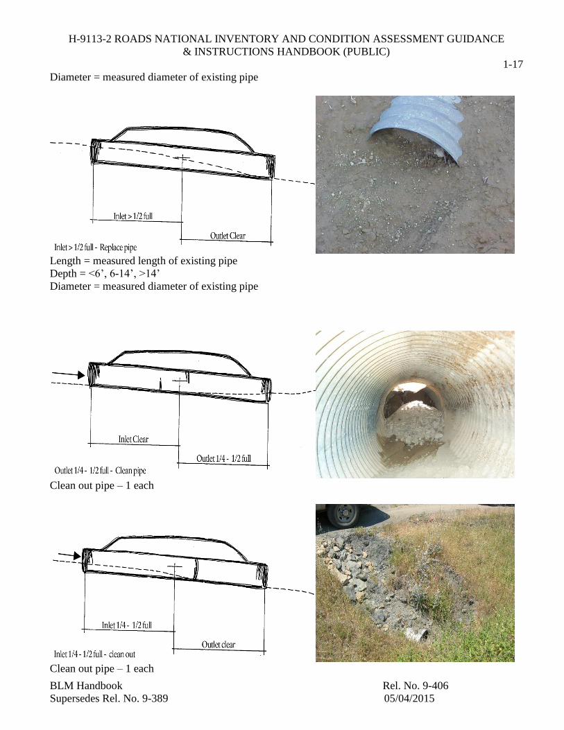
c. Culvert Condition
Poor drainage may also result from blocked or crushed culverts. The following diagrams provide
guidance for deferred maintenance items and areas to be noted, as well as the corrective action to be
captured for each deficiency. If a road intersects the road being assessed, and the intersecting road has a
culvert that lies in line (in the ditch) with the road being assessed, the culvert is not considered part of the
road being assessed – it is part of the intersecting road.
In addition to visual inspection of culverts, the field crew will test metal culverts for rust pitting with a
rock hammer or similar tool. If significant rust is encountered on the pipe interior, the pipe will be
replaced.
Length = measured length of existing pipe
Depth = <6’, 6-14’, >14’
Diameter = measured diameter of existing pipe
Length = 6’ if pipe is larger than 24” diameter; replace entire length of pipe if diameter is 24” or less
Depth = <6’, 6-14’, >14’
Diameter = measured diameter of existing pipe

H-9113-2 ROADS NATIONAL INVENTORY AND CONDITION ASSESSMENT GUIDANCE
& INSTRUCTIONS HANDBOOK (PUBLIC)
1-15
BLM Handbook Rel. No. 9-406
Supersedes Rel. No. 9-389 05/04/2015
The minimum replacement for a crushed inlet is 6 feet of pipe if the diameter is greater than 24 inches and
the entire length of pipe if the diameter is 24 inches or less. These are just guidelines to follow, actual
estimates may differ.
Length = 6’ if pipe is larger than 24” diameter; replace entire length of pipe, if diameter is 24” or less
Depth = <6’, 6-14’, >14’
Diameter = measured diameter of existing pipe
Reattach pipe – 1 each

H-9113-2 ROADS NATIONAL INVENTORY AND CONDITION ASSESSMENT GUIDANCE
& INSTRUCTIONS HANDBOOK (PUBLIC)
1-16
BLM Handbook Rel. No. 9-406
Supersedes Rel. No. 9-389 05/04/2015
Length = measured length of existing pipe
Depth = <6’, 6-14’, >14’
Diameter = measured diameter of existing pipe
Length = measured length of existing pipe
Depth = <6’, 6-14’, >14’
Diameter = measured diameter of existing pipe
Length = measured length of existing pipe
Depth = <6’, 6-14’, >14’
H-9113-2 ROADS NATIONAL INVENTORY AND CONDITION ASSESSMENT GUIDANCE
& INSTRUCTIONS HANDBOOK (PUBLIC)
1-17
BLM Handbook Rel. No. 9-406
Supersedes Rel. No. 9-389 05/04/2015
Diameter = measured diameter of existing pipe
Length = measured length of existing pipe
Depth = <6’, 6-14’, >14’
Diameter = measured diameter of existing pipe
Clean out pipe – 1 each
Clean out pipe – 1 each
H-9113-2 ROADS NATIONAL INVENTORY AND CONDITION ASSESSMENT GUIDANCE
& INSTRUCTIONS HANDBOOK (PUBLIC)
1-18
BLM Handbook Rel. No. 9-406
Supersedes Rel. No. 9-389 05/04/2015
No action – do not collect information
No action – do not collect information
No action – do not collect information
H-9113-2 ROADS NATIONAL INVENTORY AND CONDITION ASSESSMENT GUIDANCE
& INSTRUCTIONS HANDBOOK (PUBLIC)
1-19
BLM Handbook Rel. No. 9-406
Supersedes Rel. No. 9-389 05/04/2015
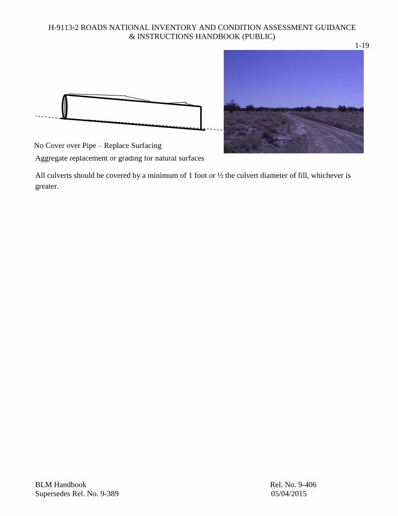
Aggregate replacement or grading for natural surfaces
All culverts should be covered by a minimum of 1 foot or ½ the culvert diameter of fill, whichever is
greater.
No Cover over Pipe – Replace Surfacing

H-9113-2 ROADS NATIONAL INVENTORY AND CONDITION ASSESSMENT GUIDANCE
& INSTRUCTIONS HANDBOOK (PUBLIC)
1-20
BLM Handbook Rel. No. 9-406
Supersedes Rel. No. 9-389 05/04/2015
The following photographs provide additional guidance about the types of deferred maintenance that may
be encountered when assessing culverts.
d. Corrugations.
PUNCTURED – REPLACE PIPE
RUSTED – REPLACE PIPE

H-9113-2 ROADS NATIONAL INVENTORY AND CONDITION ASSESSMENT GUIDANCE
& INSTRUCTIONS HANDBOOK (PUBLIC)
1-21
BLM Handbook Rel. No. 9-406
Supersedes Rel. No. 9-389 05/04/2015
Corrugations are closely spaced ridges and valleys at fairly regular intervals perpendicular to the direction
of travel. This type of distress is usually caused by traffic and is formed in areas of acceleration or
deceleration. Corrugations are estimated in square feet of surface area and cannot exceed the total area of
the road segment.
At a low severity level, the corrugations are small and are considered to be annual maintenance. At
medium severity levels, corrugations will cause an uncomfortable ride. Corrugations of high severity will
pull the steering wheel in the driver’s hands and cause the assessment personnel to proceed at a slower
pace.
The following photograph shows a natural surfaced road with severe corrugations.
H-9113-2 ROADS NATIONAL INVENTORY AND CONDITION ASSESSMENT GUIDANCE
& INSTRUCTIONS HANDBOOK (PUBLIC)
1-22
BLM Handbook Rel. No. 9-406
Supersedes Rel. No. 9-389 05/04/2015
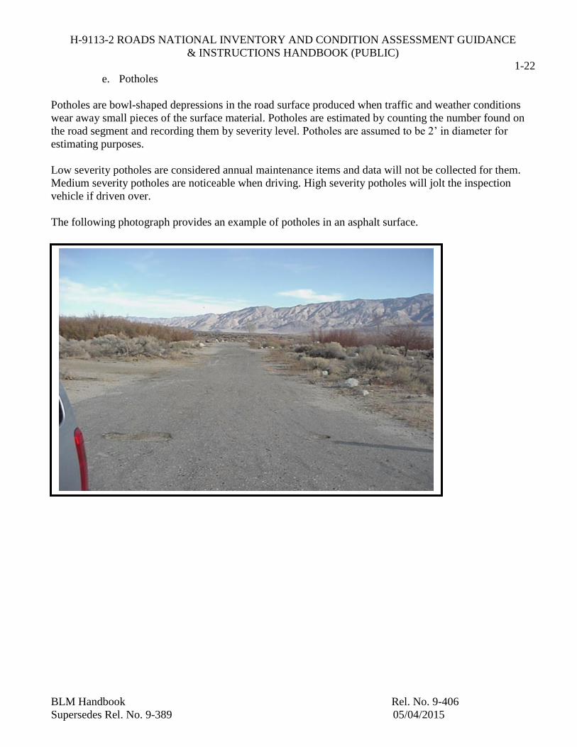
e. Potholes
Potholes are bowl-shaped depressions in the road surface produced when traffic and weather conditions
wear away small pieces of the surface material. Potholes are estimated by counting the number found on
the road segment and recording them by severity level. Potholes are assumed to be 2’ in diameter for
estimating purposes.
Low severity potholes are considered annual maintenance items and data will not be collected for them.
Medium severity potholes are noticeable when driving. High severity potholes will jolt the inspection
vehicle if driven over.
The following photograph provides an example of potholes in an asphalt surface.

H-9113-2 ROADS NATIONAL INVENTORY AND CONDITION ASSESSMENT GUIDANCE
& INSTRUCTIONS HANDBOOK (PUBLIC)
1-23
BLM Handbook Rel. No. 9-406
Supersedes Rel. No. 9-389 05/04/2015
f. Ruts
A rut is a permanent surface deformation that is typically in a vehicle wheel path parallel to the road
centerline. Ruts may also occur perpendicular to the road. Ruts are estimated in square feet of surface
area. Low severity level ruts are considered to be annual maintenance items and information will not be
collected. Medium severity ruts provide an uncomfortable ride. High severity ruts provide a rough ride in
the inspection vehicle and cause the inspection personnel to proceed at a slower pace.
The following photographs show natural surfaced roads with severe rutting.
g.

H-9113-2 ROADS NATIONAL INVENTORY AND CONDITION ASSESSMENT GUIDANCE
& INSTRUCTIONS HANDBOOK (PUBLIC)
1-24
BLM Handbook Rel. No. 9-406
Supersedes Rel. No. 9-389 05/04/2015
g. Loose Aggregate (gravel roads)
Over time, traffic will dislodge aggregate away from the normal road wheel path and cause it to form
berms at the edge of the road. Aggregate can also be depleted from the road surface by weathering and
drainage erosion. Loose aggregate is estimated in square feet of aggregate berm. Low severity berms are
annual maintenance items with no data collection required. Medium severity berms create a wheel path
that is noticeable to the driver when passing over it. Aggregate berms of high severity are difficult for a
vehicle to maneuver over.
h. Missing Aggregate (gravel roads).
Aggregate roads may be made of limestone, “pit run”, or other local crushed aggregate. A general
indication of whether aggregate replacement is required is visually noticeable areas of “lost” rock.
Replacement of lost aggregate will be estimated by square feet. Field inspection notes should indicate
whether a full depth replacement (6”) or aggregate overlay (3”) is needed. The photograph below
illustrates a road with missing aggregate.
(Note: For road segments in Western Oregon, if there is evidence that the depth of road base plus
aggregate is less than 12”, an overlay or replacement will be noted for the entire road segment.)
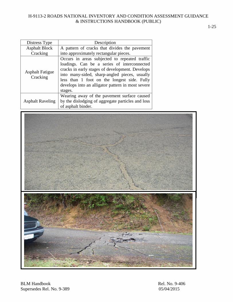
i. Cracking (paved roads)
Several types of cracking may occur on paved roads depending on subsurface conditions, traffic loading,
and pavement type/thickness. Common types of surface distress cracking for asphalt pavements are shown
in the following table. Cracking distress is estimated in either linear feet or square feet of surface
deformation.
H-9113-2 ROADS NATIONAL INVENTORY AND CONDITION ASSESSMENT GUIDANCE
& INSTRUCTIONS HANDBOOK (PUBLIC)
1-25
BLM Handbook Rel. No. 9-406
Supersedes Rel. No. 9-389 05/04/2015
Distress Type Description
Asphalt Block
Cracking
A pattern of cracks that divides the pavement
into approximately rectangular pieces.
Asphalt Fatigue
Cracking
Occurs in areas subjected to repeated traffic
loadings. Can be a series of interconnected
cracks in early stages of development. Develops
into many-sided, sharp-angled pieces, usually
less than 1 foot on the longest side. Fully
develops into an alligator pattern in most severe
stages.
Asphalt Raveling
Wearing away of the pavement surface caused
by the dislodging of aggregate particles and loss
of asphalt binder.

H-9113-2 ROADS NATIONAL INVENTORY AND CONDITION ASSESSMENT GUIDANCE
& INSTRUCTIONS HANDBOOK (PUBLIC)
1-26
BLM Handbook Rel. No. 9-406
Supersedes Rel. No. 9-389 05/04/2015
j. Vegetation Removal.
Vegetation removal will be estimated in linear feet along the road shoulders and/or centerline and in
square feet at culvert inlet/outlets. Along the road, low severity indicates some encroachment of the road
shoulder, medium indicates encroachment to the road travel edge, and high severity indicates
encroachment into the travel way. Vegetation removal is also captured for vegetation in a ditch or near a
drainage inlet. Light vegetation along the roadside is considered annual maintenance. Likewise,
tumbleweeds are a seasonal issue and are treated as an annual maintenance item.
Trees blocking the drainage ditch of a road or encroaching into the road are estimated per each for trunk
size less than approximately 6” in diameter and greater than approximately 6” in diameter. The following
photographs illustrate vegetation control items.
{need better photo}

H-9113-2 ROADS NATIONAL INVENTORY AND CONDITION ASSESSMENT GUIDANCE
& INSTRUCTIONS HANDBOOK (PUBLIC)
1-27
BLM Handbook Rel. No. 9-406
Supersedes Rel. No. 9-389 05/04/2015
k. Other Appurtenances
Cattleguards and adjacent gates will be inspected for deferred maintenance. Inspections will note missing
grates, missing wings, or the need to reset the cattleguard to grade.
Low water crossings and water bars will be noted if concrete or asphalt replacement is needed or if gravel
needs to be re-graded.
Damaged or missing signs are counted as road deficiencies.
These deficiencies are reported as deferred maintenance on the road segment however these items are not
inventoried.
The following table provides a quick reference to deficiencies estimated in the field and deferred
maintenance corrective actions.
Road Protocol
Conditions Deferred Maintenance
Standard
Measurements Corrective Action
Cross Section /
Positive Drainage
Low areas Length, Width, Depth Fill - embankment
High areas Length, Width , Depth Grading
Ditch Condition
Ditch silted in Length, Width, Depth
Ditch cleaning - remove
material.
Excessively eroded ditch Length, Width, Depth
Fill-embankment - add
material to eroded area.
Culvert Condition
Buried Pipe Length, Diameter, Depth Replace pipe
Full of Debris Length, Diameter, Depth Replace pipe
Crushed Length, Diameter, Depth Replace pipe
<1/2 full of debris Quantity (number of
pipes to clean) Clean Pipe
1/2+ full of debris Length, Diameter, Depth Replace pipe
Inlet / Outlet crushed
Length, Diameter, and
depth
Replace Inlet / Outlet - 6' if
diameter > 24”. Replace
pipe, if diameter 24” or
less.
No cover over pipe
Length, Width and
Depth Replace surface material
Corrugations Washboarding/corrugations
Length, Width and
Severity Level Grading
Potholes
Potholes - Natural
Number and average
depth( 4-6” or >6”) Grading
Potholes - Aggregate
Number and average
depth( 4-6” or >6”) Aggregate replacement
Potholes - Asphalt
Number and average
depth( 4-6” or >6”) Machine patching

H-9113-2 ROADS NATIONAL INVENTORY AND CONDITION ASSESSMENT GUIDANCE
& INSTRUCTIONS HANDBOOK (PUBLIC)
1-28
BLM Handbook Rel. No. 9-406
Supersedes Rel. No. 9-389 05/04/2015
Road Protocol
Conditions Deferred Maintenance
Standard
Measurements Corrective Action
Ruts
Rutting - Natural
Length, Width and
Severity Level Grading
Rutting - Aggregate
Length, Width and
Severity Level Aggregate replacement
Rutting - Asphalt
Length, Width and
Severity Level Machine patching
Loose Aggregate Loose Aggregate Length, Width Grading
Missing
Aggregate Missing Aggregate
Length, Width (Depth is
3") Aggregate Overlay
Missing
Aggregate Missing Aggregate
Length, Width (Depth is
6”) Aggregate Replacement
Cracking (paved
roads)
Block Cracking Length Crack Sealing
Fatigue Cracking Length and Width Chip seal or Sealcoat
Raveling Length and Width
Bituminous Machine
Patching
Vegetation
Removal
Vegetation hand clearing Length and Width
Brush removal with hand
saw
Vegetation at culvert
inlet/outlet Each
Brush removal with hand
saw
Brush Mowing Length and Width
Clearing, brush mowing
with tractor
Tree Removal < 6" Quantity – Each Remove selective trees
Tree Removal > 6" Quantity – Each Remove selective trees
Other Appurtenances
Cattleguard
Replace wing(s) Quantity – Each Replace Cattleguard wings
Replace entire cattleguard
(8x14) Quantity – Each
Replace entire Cattleguard
(wings, base, grate, etc.)
Repair wing(s) Quantity – Each Repair wings (reattach, etc)
Cleaning Quantity - Each Clean cattleguard
Missing/Damaged Gates Quantity – Each Replace gates
Guardrail Damaged Guardrail Length Replace Guardrail
Signage Damaged or Missing Sign Quantity - Each Replace Sign

H-9113-2 ROADS NATIONAL INVENTORY AND CONDITION ASSESSMENT GUIDANCE
& INSTRUCTIONS HANDBOOK (PUBLIC)
1-29
BLM Handbook Rel. No. 9-406
Supersedes Rel. No. 9-389 05/04/2015
Field Data Entry
A paper form (Appendix A - Road Condition Assessment Form) is used to capture deficiencies found on
the road segment. At the end of each road segment, deficiencies are tallied and saved.
9. Field Assessment Checklist
The following checklist is provided to promote field work that is organized and efficient. The
checklist emphasizes the need for the Field Assessment Personnel to establish a clear and
repeatable work routine each time they begin and end the assessment of any given road. These
steps are not all inclusive, but do represent the minimum that is required. Establishing a repeatable
routine is the most effective way to eliminate errors and omissions and to increase efficiencies.
□ Obtain your assessment schedule and any background information available on each road
listed on the schedule. Confirm all travel arrangements.
□ Contact and verify the schedule with the PM, Assessment Leader, and/or the BLM Field
Office personnel. Arrange to meet BLM staff as they are to accompany the Assessment
Personnel.
□ Assemble the required tools and equipment to conduct the onsite inventory and assessment
work.
□ Ensure that all electronic equipment is functioning prior to leaving the home base.
□ Review the schedule to determine the roads to be assessed that day.
□ Arrange for pickup or rendezvous of escorts.
□ Once at the site, follow detailed instructions provided for gathering and entering data.
□ Remember to take photos and GPS shots as required (baseline versus re-inspection).
□ Review data gathered for assessment for completeness prior to leaving a road segment..
□ Document inaccessible roads and rationale for no-inspection.
□ Document roads that do not appear to meet road definition (Manual Section 9113 - Roads).
10. Summary
Summary of Tasks Phase II - On-Site Data Collection. Tasks to be completed in the field include:
Inventory of the entire length of all road segments (name, length, width, surface type, terrain,
primitive road).
Identification of potential health and safety items on the entire length of all road segments.
Measurement of road deficiencies.
Identify inaccessible/Not Inspected Road Segments and Rationale.
Identify road segments that do not meet BLM Road Definition (Manual Section 9113 - Roads).

H-9113-2 ROADS NATIONAL INVENTORY AND CONDITION ASSESSMENT GUIDANCE
& INSTRUCTIONS HANDBOOK (PUBLIC)
1-30
BLM Handbook Rel. No. 9-406
Supersedes Rel. No. 9-389 05/04/2015
C. Phase III – In-Office Data Entry
Phase III requires assessment personnel to complete the inventory and assessment process through a
review of the collected information, alignment of GIS spatial data, photos, inventory, and deferred
maintenance information. Office staff will review the data for completeness and communicate any
missing data elements to assessment personnel. Assessment personnel will review their road segment
information posted in the holding database when they return to the office. They are responsible for the
completeness and correctness of all data gathered.
1. General
In-Office Data Entry may be completed by the assessment personnel or a combination of office
staff and assessment personnel as necessary to complete the data requirements. In-Office Data
Entry includes:
Inventory
o GIS spatial data (collected with a GPS device) review and cleanup
o Attachment of Road photos to Roads
o Review of Road and Road Segment Inventory data and alignment with GIS
Spatial Information
Condition Assessment
o Validate quantities for each deficiency
o Validate appropriate cost models were attached to each deficiency
o Validate deficiencies are connected to the appropriate road segment
o Follow-up with Local BLM POC on Critical Health and Safety
2. Specific Tasks
Assessment personnel (which would generally include personnel from Phase II as well as office
support staff) will complete the following tasks:
i. Review on-site data collected under Phase II.
ii. Validate GIS spatial data aligns with road segments in work-plan (Phase I).
iii. Clean up GIS spatial data (extra data points, lack of coverage, etc.) to produce good GIS
linework.
iv. Create “bridge” spatial segments if necessary to provide continuous segments.
v. Review inventory and deferred maintenance data for accuracy and completeness utilizing
the BLM Deferred Maintenance Costing System.
vi. Validate appropriate deferred maintenance cost models are attached to each deficiency.
vii. Attach recommended Asset Classification and associated CRV Model.

H-9113-2 ROADS NATIONAL INVENTORY AND CONDITION ASSESSMENT GUIDANCE
& INSTRUCTIONS HANDBOOK (PUBLIC)
1-31
BLM Handbook Rel. No. 9-406
Supersedes Rel. No. 9-389 05/04/2015
viii. Create ad-hoc cost estimates to correct deficiencies if required.
ix. Review office data and develop integrated work product (combination of GIS spatial data,
tabular inventory data, photos, and deferred maintenance data) for each road segment.
3. Summary – Phase III – In-Office Data Entry
At the conclusion of in-office data entry assessment personnel will have a complete roads
inventory and condition assessment product that has been reviewed and determined to be complete
by assessment personnel. Tasks that will have been completed include:
Completed GIS spatial data compliant with BLM GIS data standards (if required)
Completed Inventory requirements for roads assigned within the work-plan
Determined deferred maintenance requirements for each road segment
Integrated all work products into a result suitable for independent quality review
D. Phase IV Data Quality Assurance and Review
Phase IV will be accomplished by individuals who were not involved in Phase II and Phase III. The
independent review is intended to validate the quality and completeness of the information collected
during the previous Phases. The independent review is not intended to imply acceptance by the BLM,
but rather validate that all the required work products are complete and prepared for submittal to the
BLM.
1. General
This effort should generally be accomplished by knowledgeable personnel (ideally assessment
personnel not involved with the specific effort or Field Office) and also reviewed by the
Assessment Leader. At the conclusion of this Phase, the Assessment is complete and should be
ready for delivery/transfer to the BLM POC.
2. Specific Tasks
Tasks to be completed in this phase include:
i. Review of field notes against database.
ii. Review of GPS road spatial information in GIS system.
iii. Review of Inventory database fields for completeness.
iv. Review of deferred maintenance calculations for reasonableness.
v. Validation of selected Asset Class/Cost Code and associated CRV model.
H-9113-2 ROADS NATIONAL INVENTORY AND CONDITION ASSESSMENT GUIDANCE
& INSTRUCTIONS HANDBOOK (PUBLIC)
1-32
BLM Handbook Rel. No. 9-406
Supersedes Rel. No. 9-389 05/04/2015
vi. Review of Integrated Work product.
vii. Review of Road Segments not inspected and associated rationale.
viii. Development of Submittal package for the completed work plan:
For all baseline road segments identified for inventory and assessment
GIS Spatial data in BLM specified format
Road Segment Inventory complete in specified format
Photos attached to inventory in specified format
Appropriate Cost Model and CRV data in specified format
Deferred maintenance deficiencies in specified format
For all baseline recommended new road segments
GIS Spatial data in BLM specified format
Road Segment Inventory complete in specified format
Photos attached to inventory in specified format
Appropriate Cost Model and CRV data in specified format
Deferred maintenance deficiencies in specified format
For all re-inspected road segments
Road Segment Inventory complete in specified format
Photos attached to inventory in specified format
Appropriate Cost Model and CRV data in specified format
Deferred maintenance deficiencies in specified format
ix. Submit data to BLM for review and acceptance.
3. Summary
Phase IV – Quality Assurance and Review. At the conclusion of the quality assurance and review
(Phase IV) deliverables should be complete in accordance with the work-plan and BLM inspection
standards and ready for review and acceptance testing by the BLM. Deliverables should be
provided electronically in accordance with the work plan and statement of work. Partial submittals
should only occur when they are part of the work-plan and partial submittals still require a
complete set of data for each road segment.
The completed submittal will have been independently reviewed and approved for submittal to the
BLM POC in the specified format and delivered, constituting the end of the work-effort for
specific work plan (note individual field offices may include multiple work plans and a work plan
may be as simple as a single road or as complex as an entire BLM Field Office inventory of roads).

H-9113-2 ROADS NATIONAL INVENTORY AND CONDITION ASSESSMENT GUIDANCE & INSTRUCTIONS HANDBOOK
(PUBLIC)
A-1
BLM Handbook Rel. No. 9-406
Supersedes Rel. No. 9-389 05/04/2015
APPENDIX A – ROAD CONDITION ASSESSMENT FORM

H-9113-2 ROADS NATIONAL INVENTORY AND CONDITION ASSESSMENT GUIDANCE & INSTRUCTIONS HANDBOOK
(PUBLIC)
A-2
BLM Handbook Rel. No. 9-406
Supersedes Rel. No. 9-389 05/04/2015
ROAD CONDITION ASSESSMENT FORM
Deficiency Types Quantification Severity
Unit of Measure Capture QTY Low Medium High
EA Total EA Total EA Total
Ditch Condition LF Each 100 LF N/A N/A 1” Depth 3‘Width 2” Depth 3‘Width
Cut – Ditch Clearing (length, width and depth) LF Each 100 LF N/A N/A Fill – Ditch Clearing (length, width, and depth) LF Each 100 LF N/A N/A
Vegetation Removal N/A N/A
Along Roadway (assume 3” width)
At Culver Inlet/Outlet
Brush Mowing (assume 3” width)
Tree Removal (< 6” diam.)
Tree Removal (3” to 6” diam.)
Ruts LF Each 10 LF N/A N/A 4” – 6” Depth 6” + Depth
Ruts ( assume 9” – 12” width) LF Each 10 LF N/A N/A
Potholes EA EA N/A N/A 4” – 6” Depth 6” + Depth
Potholes (assume 2’ diam.) EA EA N/A N/A
Missing Aggregate LF Each 100 LF N/A N/A Overlay 3” Full Depth 6”
Missing Aggregate (assume width of roadway) LF Each 100 LF N/A N/A
Loose Aggregate LF Each 10 LF N/A N/A
Loose Aggregate (assume 3’ to 4’width) LF Each 10 LF N/A N/A
Corrugations/Washboarding LF Each 10 LF N/A N/A 4” – 6” Depth 6” + Depth
Corrugations/Washboarding (assume width of road) LF Each 10 LF N/A N/A
Cross Section/Positive Drainage SF Each 100 SF N/A N/A 1” Depth 3” Width 2” Depth 3” Width
Fill – Embankment SF Each 100 SF N/A N/A
Cut - Excavation SF Each 100 SF N/A N/A
Washout SF Each 25 SF N/A N/A
Culvert Condition Diameter Length Type Depth Condition/Corrective Action (buried
pipe, debris level, crushed pipe or
inlet/outlet, no pipe cover)
1 2 3 4
1 2 3 4
1 2 3 4
1 2 3 4
1 2 3 4
1 2 3 4
1 2 3 4
Other Appurtenances (signs, gates, cattleguards,
low water crossing, guardrail)
Length Width N/A N/A Quantity
(EA and SF
length for
guardrails)
Condition/Corrective Action
Bituminous Repair (Paved Roadways) N/A N/A Seal Coat/
Crack
Sealing
Bituminous Overlay 3”
Asphalt Overlay SF Each
25 SF
Fatigue Cracking SF Each
25 SF
Block Cracking LF Each
10 LF
Alligator/Transverse Cracking SF Each
25 SF
Raveling (at edge 1’width) LF Each
10 LF
Potholes (assume 2’diam.6” depth) EA EA
Potential Critical Health and Safety Items:
Comments:
ROAD NAME:
ASSESSORS:
ROAD LOC NUM
SEGMENT LOC NUM
BEGIN
MILEPOST:
END
MILEPOST:
STATE & DISTRICT:
COUNTY:
BEGIN
ODOMETER:
END
ODOMETER:
DATE:
SURFACE
TYPE:
BEGIN INSPECTION
TIME:
END INSPECTION TIME:
SURFACE
WIDTH:
BEGIN SEGMENT
PHOTO:
END SEGMENT PHOTO:

H-9113-2 ROADS NATIONAL INVENTORY AND CONDITION ASSESSMENT GUIDANCE
& INSTRUCTIONS HANDBOOK (PUBLIC)
B-1
BLM Handbook Rel. No. 9-406
Supersedes Rel. No. 9-389 05/04/2015
APPENDIX B – GUIDANCE ON TERRAIN TYPES

H-9113-2 ROADS NATIONAL INVENTORY AND CONDITION ASSESSMENT GUIDANCE
& INSTRUCTIONS HANDBOOK (PUBLIC)
B-2
BLM Handbook Rel. No. 9-406
Supersedes Rel. No. 9-389 05/04/2015
Guidance on Terrain Types.
The following examples are to be used to determine the terrain type for a road segment. Each road
segment will have only one ‘average’ terrain type.
Flat Terrain
Road segments in flat terrain (<15% side slopes) have little elevation deviation from the surrounding area.
These road segments may be elevated or depressed slightly and are commonly found in open plains areas.
Road in flat terrain would require only minimal earthwork in construction.
Example of road segment in flat terrain:
Rolling Terrain
Road segments in rolling terrain (16 – 30% side slopes) will deviate an average of 3 feet from the
surrounding land. Earthwork required to construct a road in rolling terrain will average 3 feet of cut or fill
height.
Example of road segment in cut in rolling terrain:
Example of road segment in fill in rolling terrain:
<15% Slope
16 – 30% Slope
16 - 30% Slope

H-9113-2 ROADS NATIONAL INVENTORY AND CONDITION ASSESSMENT GUIDANCE
& INSTRUCTIONS HANDBOOK (PUBLIC)
B-3
BLM Handbook Rel. No. 9-406
Supersedes Rel. No. 9-389 05/04/2015
Mountainous Terrain
Road segments in mountainous terrain (>30% side slopes) are characterized by steep back slopes and fore
slopes. Typically, construction of roads in mountainous terrains will be more costly due to increased
excavation or fill heights and difficulties of transporting equipment and materials to the road site.
Example of road segment in mountainous terrain:
>30% Slope
Sample 3 Road Designation 7116-00 (ML 3) Segment 1 - 3 Miles in
Length
Mile 3 Mile 2 Mile1