Bullsbrook Townsite & Rural Strategy City of Swan Endorse · coastal plain section of the study...
14
Bullsbrook Townsite & Rural Strategy (City of Swan Endorsed Draft) 8 SEPTEMBER 2008 93 SECTION 3: OPPORTUNITIES AND CONSTRAINTS
-
Upload
nguyendung -
Category
Documents
-
view
214 -
download
0
Transcript of Bullsbrook Townsite & Rural Strategy City of Swan Endorse · coastal plain section of the study...

Bullsbrook Townsite & Rural Strategy (City of Swan Endorsed Draft) 8 SEPTEMBER 2008
93
SECTION 3: OPPORTUNITIES AND
CONSTRAINTS
Bullsbrook Townsite & Rural Strategy (City of Swan Endorsed Draft) 8 SEPTEMBER 2008
94

Bullsbrook Townsite & Rural Strategy (City of Swan Endorsed Draft) 8 SEPTEMBER 2008
95
OVERVIEW This section outlines the land capability of the study area to existing land uses
and the potential for future uses, as well as an analysis of the demand for specific land uses that has been observed within the study area. This section also reviews the relevant planning opportunities and constraints outlined in previous sections, in order to formulate the creation of appropriate land use precincts that will guide future land use.
15.0 LAND CAPABILITY ASSESSMENT The Land Capability Assessment that was undertaken in this strategy relies heavily on the work presented in the Ellen Brook Catchment Management Plan (PPK Environment & Infrastructure et. al. 2000). As part of this work, a land capability audit was carried out using GIS and two datasets, with data linked to land types and existing land uses (PPK Environment & Infrastructure et. al. 2000).
This analysis, along with descriptive data for environmental characteristics of the region, then led to the selection of a number of Environmental Management Units that required differentiated management techniques (PPK Environment & Infrastructure et. al. 2000). The original GIS Land Capability Assessment, along with the guidelines attributed to the creation of Environmental Management Units (EMU) is outlined below.
15.1 Land Capability Audit of Bullsbrook Study Area
The land capability audit was carried out using a GIS and two datasets, land capability data linked to land types and existing land uses. The land capability data was used to intersect the land use data, and from this, each land use polygon was tagged with a capability rating. These results should be used as a guide only to land capability throughout the study area, and a detailed field survey should be undertaken as part of any structure plan for future development.
a) Grazing
The land capability mapping for grazing shows that the majority of the coastal plain section of the study area has fair to low capability for this use (Figure A37). There are some small areas of moderately high capability associated with water courses in the eastern part of the study area, around the Avon and Brockman Rivers.
Land units of the Dandaragan plateau have fair to moderately low capability for grazing. The Darling Range land units range from having high to fair capability for grazing with limited areas of low capability in restricted portions.
b) Perennial Horticulture Use
Land capability assessment for perennial horticulture (Figure A38) shows low capability for the low lying central portion of the coastal catchment. The Dandaragan plateau has land units ranging from high to

Bullsbrook Townsite & Rural Strategy (City of Swan Endorsed Draft) 8 SEPTEMBER 2008
96
fair capability with some restricted areas of low capability associated with watercourses. Land units in the Darling plateau are variable with some areas ranging from low to high capability for perennial horticulture. The area to the west on the coastal plain shows a high capability for perennial horticulture but the Gnangara UWPCA area would preclude developments of this sort.
c) Annual Horticulture
Land capability assessment for annual horticulture shows low to fair capability for the low lying central portion of the coastal catchment with fair to high capability on the Dandaragan plateau (Figure A39). The Darling Plateau shows primarily low capability for annual horticulture, especially throughout water course areas associated with the Avon and Brockman Rivers (Figure A39).
d) Urban Land Use
Land capability ratings for urban (sewered residential) show that most of the areas deemed to have a high capability are located on the western side of Great Northern Highway, as well as areas to the north and east of the current Bullsbrook town site (Figure A40).
The low lying portion of the coastal plain has a low to fair capability, though it should be noted that the suitability of this land use would depend on other factors such as infrastructure servicing and the nature of measures that manage potential problems highlighted in the capability assessment. Limiting factors for much of the low lying coastal portion of the catchment would include shallow depth to the water table and the risk of phosphorous loss.
Some sections of the Bullsbrook townsite, primarily adjacent to the Ki-it Brook and south of the current Wastewater Treatment Plant, are also deemed to have a moderate-low capability for urban development. Subsurface drainage combined with imported fill for urban development, together with an integrated plan for water sensitive urban design practices to deal with stormwater management, may reduce the adverse impacts likely to arise if urban use was established on this low capability land.
The Upper Swan area has been deemed to have high capability land for urban uses in the southern sections of the study area, on both sides of the Great Northern Highway. The north-western section of Upper Swan is deemed to have a moderately low capability, though this may be able to be mitigated through the process previously outlined for the moderately low capability land within the Bullsbrook townsite.
e) On-Site Effluent Disposal
Areas of the Dandaragan and Darling Plateau are shown to have fair to high capability for on-site effluent treatment, with the exception of those areas adjacent to the Avon and Brockman River systems (Figure A41). The western section of the study area primarily has a low capability for on-site effluent systems, due to the sensitivity of the Ellen Brook
Bullsbrook Townsite & Rural Strategy (City of Swan Endorsed Draft) 8 SEPTEMBER 2008
97
catchment. This pattern is very similar to the assessment of land capability for urban development (Figure A41).
15.2 Environmental Management Units of the Ellen Br ook Catchment
The results of the Ellen Brook Catchment Management Plan (PPK Environment & Infrastructure et. al. 2000) outlined a comprehensive analysis of the land capability of the Ellen Brook Catchment Area. This process involved the division of the Ellen Brook Catchment into a series of Environmental Management Units, based on an adaptation of the system used to classify management units for the Shire of Chittering Land Capability and Management Plan (Figure A42). Criteria used to define the environmental planning units included:
• Geomorphic Province –Swan Coastal Plain, Dandaragan Plateau and Darling Range
• Major Catchments –Ellen Brook, Brockman River and Moor River
• Soil Landscape Systems (parent mapping units used in the Agriculture WA surveys)
• Sub-catchments or groupings of sub-catchments as previously defined by the Swan River Trust
• Consanguineous wetland suites classification.
The Environmental Management Units formed within the Ellen Brook Catchment Management Plan (PPK Environment & Infrastructure et. al. 2000) are essentially a smaller sub-set of those described in the Shire of Chittering Land Capability and Management Plan. This break-down of EMU’s allowed the categorisation of descriptive data for each unit, including general characteristics, drainage characteristics and sub-catchments, vegetation cover, riparian vegetation cover and soil landscape characteristics. In addition to this, precinct specific guidelines were created based on the land’s capability and its management.
Environmental Management Units for the Ellen Brook Catchment that fall within the study area include SC1, SC2, SC3, DN1 and DR11, as shown in Figure A42. A brief description of each of these EMU’s is outlined below, with a more detailed description available within the Ellenbrook Catchment Management Plan3.
a) Environmental Management Unit SC1 South (Far Wes tern Study Area)
This unit spans 87,950 Ha along the western boundary of the Bullsbrook Study Area (Figure A42). The unit is located on the Swan Coastal Plain Aeolian and fluviatile deposits. The soils exhibit deep sands with poor phosphorus retention capacity, and the area is highly susceptible to phosphorus export, salinity, waterlogging and wind erosion.
The risk of land degradation would increase with clearing, overstocking and development without consideration of land capability constraints.
3 For more detailed information relating to each of these units refer to the Draft Ellen Brook Catchment Management Plan (PPK Environment & Infrastructure et. al. 2000)

Bullsbrook Townsite & Rural Strategy (City of Swan Endorsed Draft) 8 SEPTEMBER 2008
98
b) Environmental Management Unit SC2 (Mid Western S tudy Area)
i) SC2 –Rutland Road (Northern Study Area)
This unit spans 10,200 ha in the north western corner of the study area to the north-western section of the Bullsbrook town site, encompassing the eastern banks of the Ellen Brook. It is located on the Swan Coastal Plain fluvatile deposits and Dandaragan Plateau Scarps. The soils are predominantly deep sands with some gravely sands associated with the Reagan soil landscape system on the Dandaragan Plateau.
The phosphorus retention capacity is poor for the deep sands and medium to high in the gravely sands. The unit has been heavily cleared, and has large areas that are highly susceptible to nutrient export, salinity, waterlogging and wind erosion.
Management of the unit should include revegetation and protection of existing remnant vegetation is of prime importance in mitigating and preventing land degradation. The clearing of remaining vegetation, overstocking or development without consideration of land capability constraints will result in further degradation.
ii) SC2 –Railway Parade (Central Study Area)
This unit spans 49180 ha in the central portion of the study area, from north-western section of the study area to the Warbrook Road area, encompassing the western banks of the Ellen Brook. The unit is located on the Swan Coastal Plain fluviatile and Aeolian deposits, with predominantly deep sands with poor phosphorus retention properties.
This area has been extensively cleared with only 10% of the entire unit covered by vegetation, and as a result large areas are highly susceptible to phosphorus export, salinity, waterlogging and wind erosion. The re-establishment of vegetation and protection of existing remnants should be a high priority in this area, and future development should be assessed based on land capability constraints.
c) Environmental Management Unit SC3 (Southern Stud y Area)
This unit spans 21,830 Ha in the southern study area, encompassing parts of southern Bullsbrook and Upper Swan on the eastern side of the Ellen Brook. The unit is located on the Swan Coastal Plain fluviatile and Aeolian deposits, with soils predominantly of deep sands with poor phosphorus retention properties. There are however some duplex and gradational soils in the south of the unit with a moderate to high phosphorus retention capability.
This area has been heavily cleared and as such large areas are susceptible to nutrient export, salinity, waterlogging and wind erosion, and to a lesser degree flooding. The risk of land degradation is proposed to increase with clearing, overstocking and development without consideration for land capability constraints.

Bullsbrook Townsite & Rural Strategy (City of Swan Endorsed Draft) 8 SEPTEMBER 2008
99
d) Environmental Management Unit DN1 (Northern Stud y Area)
This unit spans 78,920 Ha from the northern townsite area of Bullsbrook to the northern boundary of the study area (Figure A42). The unit is situated on the Dandaragan Plateau, and consists of undulating and gently sloping uplands with some sandy and gravely soils. The phosphate adsorption capacity of these soils is medium to high.
The unit has a moderate susceptibility to salinity, flooding, waterlogging and phosphorus export, but is at significant risk from wind erosion. The widespread clearing of the unit has increased its susceptibility to land degradation, and the continued clearing, overstocking and development without consideration for land capability constraints increase the risk of these land degradation processes occurring.
e) Environmental Management Unit DR11 (South-Easter n Study
Area)
This unit spans 16040 Ha from the eastern section of the Bullsbrook town site, along the eastern border of the study area to the south-eastern corner of Upper Swan (Figure A42). The unit is situated on the Darling Plateau and includes major valley floors and scarps, with soils ranging from sands to loamy earths. The Phosphorus adsorption capacity of these soils is generally medium to high, and therefore phosphorus exported from this area is predominantly in particulate forms.
The unit exhibits low susceptibility to salinity, waterlogging and flooding, and moderate susceptibility to wind erosion, although large areas of the unit are highly susceptible to phosphorus erosion. These management risks are exacerbated by the sparse coverage of remnant vegetation, which requires addressing to mitigate issues of water erosion and phosphorus export. The clearing of remaining vegetation will risk further land degradation, and as such consideration of land capability should be applied to development proposals.
Bullsbrook Townsite & Rural Strategy (City of Swan Endorsed Draft) 8 SEPTEMBER 2008
100
16.0 MARKET DEMAND ANALYSIS The following information outlines the direct and potential demand for land within the study area to be used for specific activities that have been observed by the City of Swan. This is not a review of all development applications that have been received for the study area, but rather a general indication of the types of land uses that have the potential to be marketable within certain locations of the study area.
16.1 Residential Demand
According to observations, the demand for land within the study area for residential use varies depending on the location and access to essential services, as well as the surrounding residential densities.
The relative success of the establishment of the medium density Ellen Brook residential development has led to increased pressure for expansion of this urban area to include southern parts of the Bullsbrook study area. This includes proposals to expand medium density residential areas in to Upper Swan and the south-western corner of the Bullsbrook study area.
Any expansion of the Ellen Brook community in to these areas will be dependent upon the availability of service infrastructure, the suitability of the local environment to support such land use, and the protection of valuable agricultural and rural land within the region.
There is also a relative degree of demand for medium density residential expansion in the southern areas of the Bullsbrook town site, after the publication of the Bullsbrook Town & Environs Plan (Shire of Swan 1998) and the North East Corridor Extension Strategy (WAPC 2003) indicated this to be a future urban growth node. Many of these lots have since undergone MRS amendments to urban deferred, and development will be subject to servicing availability and the withdrawal of an extractive industries licence for an area to the immediate south-east.
16.2 Rural-Residential Demand
Demand for rural-residential expansion, averaging lot sizes of between 2ha and 4ha, has been commonly observed in the eastern hills of the study area. This is primarily proposed as an expansion of the existing rural-residential community in this area, though there are significant issues of environmental sensitivity and protection of the visual resource areas throughout the Darling Scarp.
The major development proposal for this area is that of the large holdings known as the Deveraux Farm, which covers an area of almost 2,500 hectares in the eastern section of the study area. This proposal has thus far obtained necessary approvals under the current planning controls to develop a section of this land, subject to the provision of necessary services and infrastructure.
Further expansion of low density residential development outside of the area zoned ‘rural-residential’ under Local Planning Scheme No. 17 is generally not supported, as :
• Low density residential development is not considered to be a sustainable use of land, and is considered to be detrimental to the
Bullsbrook Townsite & Rural Strategy (City of Swan Endorsed Draft) 8 SEPTEMBER 2008
101
objectives of this Strategy and the North East Corridor Extension Strategy (WAPC 2003)
• The eastern part of the study area is deemed to be of moderate-extreme bushfire risk (Figure A35), and further development could risk human safety
• The eastern hills area's reliance on on-site water provision may produce servicing difficulties in a drying climate.
The development of rural-residential sized blocks on the periphery of the Bullsbrook and Upper Swan town site areas may be considered as a transition between the urban and natural environment. This type of development would need to be considered as part of the overall context of the townsite development, however, as residents will be reliant on servicing, infrastructure and potential employment that the town site development will provide.
16.3 Agricultural Demand
Demand for land to be used for agricultural purposes observed by the City of Swan is relatively low within the study area, and is primarily focused on horticultural and other intensive forms of agriculture. Less intensive forms of agriculture, such as broad acre farming, had very low levels of demand for land use.
The low levels of demand for larger lots suitable for broad acre farming may be attributed to the decreasing viability of this type of production, due to lower rainfall and falling commodity prices. Low levels of demand may also be attributed to increasing land values within the study area resulting in greater economic gain through the sub-division of larger lots for alternative land uses.
The relatively higher levels of demand for more intensive forms of agriculture include applications for horticultural activities, vineyards, various forms of animal husbandry and agistment. These forms of agriculture may prove more viable due to their smaller lot sizes and niche market, though many of these activities require higher levels of water and fertiliser than broad acre farming. It is anticipated that technological improvements in water supply and fertiliser application, as well as changes in agricultural practices, will assist in increasing the viability of rural and agricultural activities throughout the Bullsbrook region.
Areas of ‘Potential Agricultural Significance” have been identified as part of mapping produced for the North East Corridor Extension Strategy (WAPC 2003) (Figure A29). This mapping was produced based on areas of moderate-high and high capability agricultural land that exist outside of identified constraints, as well as existing horticultural/agricultural ventures. (Figure A29).
Although some rural and agricultural activities may not be considered viable at present within the Bullsbrook area, the City of Swan considers that protection of broad acre farming properties is essential to maintaining the supply of rural commodities within the Perth Metropolitan Area. With an increasing cost of transportation of agricultural products, the protection of food supply to major cities such as Perth will become increasingly difficult, and this may increase the viability of properties in proximity to the metropolitan area, including Bullsbrook.
Bullsbrook Townsite & Rural Strategy (City of Swan Endorsed Draft) 8 SEPTEMBER 2008
102
16.4 Industrial Demand
Strong levels of demand for land suitable for light industrial expansion within the study area have been the result of the large lot sizes and relatively cheap land available within close proximity to the metropolitan area, and the major transport route available through the use of Great Northern Highway. The City has undertaken a number of planning exercises to investigate the feasibility for industrial land use within the study area, resulting in a number of previous proposals for suitable industrial sites. Many of these proposals have not progressed, due to a number of factors, including land owner complications, environmental constraints and servicing difficulties.
Under the recommendations of the North East Corridor Extension Strategy (WAPC 2003), the creation of further employment within the study area would be essential in supplying an adequate employment retention ratio for an increased residential population. The establishment of the proposed Muchea Employment Node will go towards retaining employment within the local area, but the support of light industrial opportunities within the study area is also viewed as essential to the creation of local employment.
The community consultation indicated that their was widespread support for industrial development south of the RAAF Pearce base, between Great Northern Highway and the Perth-Geraldton Railway. The City considers this to be conceptually appropriate, but in need of more detailed study and analysis.
In addition to this there has been demand for industrial land use to the north of the Bullsbrook townsite. This type of land use may have the potential employment and economic development for the development of the Bullsbrook town site. However, any industrial development in this area would need to be cognisant of the urban environment to the south, and would significant buffer zones would be required.
16.5 Transport Depot Demand
A number of major regional, inter-regional and interstate transport routes converge upon the City of Swan, which makes the City convenient for the establishment of transport companies. This attribute, along with the availability of appropriate sized lots adjacent to major transport routes, also makes the area desirable for parking of commercial vehicles involved with other businesses and trades.
The demand for Transport Depot development in Bullsbrook is increasing, as these large space users are driven out of inner metropolitan industrial areas by smaller scale land uses. The availability of relatively cheap land in Bullsbrook has resulted in an increased demand for large lots in the proximity of Great Northern Highway to be converted to Truck Depots.
The number and size of vehicles, the associated infrastructure and the type of activity at premises have the potential to adversely affect the amenity of the surrounding area by way of noise, fumes, visual appearance and pollution. Vehicles may also impact upon the safety of the area by way of the type of load carried and the suitability of the roads used to access the premises.
There is a need for the identification of suitable land for the development of heavy haulage vehicle storage within the study area. This type of development needs to occur in an area with:
Bullsbrook Townsite & Rural Strategy (City of Swan Endorsed Draft) 8 SEPTEMBER 2008
103
• high accessibility for vehicle transport
• complementary land uses in close proximity, including light industrial and rural industrial activities
• low susceptibility to environmental degradation
• low visual sensitivity for the surrounding rural environment
The allocation of rural land within the study area for the development of transport depots is expected to meet existing demand for this land use and consolidate this type of development in a more suitable area.
16.6 Commercial Demand
Land for the expansion of commercial activities within the study area has been the result of increasing population of the region and the significant issues facing the current commercial area. Within the townsite, commercial activities are limited to the shopping complex on the western side of Great Northern Highway, and a mixed business, café and drive-thru coffee shop on the eastern side. The current commercial centre is experiencing significant difficulties in allowing safe access and sufficient parking within their area, and there is inadequate land available for the expansion of their businesses (Quick Ideas 2007).
As part of the community consultation that went into the Bullsbrook State of the Economy Report (Quick Ideas 2007) many businesses voiced their concerns over issues of inadequate room for expansion. The lack of diverse and safely accessible commercial and retail opportunities within the townsite was also a common issue in the community consultation undertaken with Bullsbrook residents in 2007 (Quick Ideas 2007).
The North East Corridor Extension Strategy (WAPC 2003) outlines that under a population scenario of 10,500 residents within the area, Bullsbrook would need to be established as the District Centre, providing retail and local office, health, welfare and community facilities, which would form part of the employment base. Under the Statement of Planning Policy No. 4.2: Metropolitan Centres Policy statement for the Perth Metropolitan Region (WAPC 200b) the guidelines for a District Centre indicate that shopping floor space should be confined to 15,000m2, subject to a Local Planning Strategy or structure planning.
Bullsbrook Townsite & Rural Strategy (City of Swan Endorsed Draft) 8 SEPTEMBER 2008
104
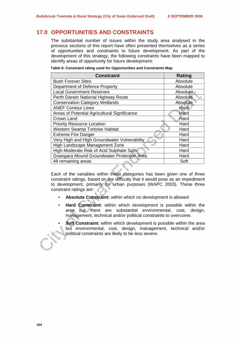
17.0 OPPORTUNITIES AND CONSTRAINTS The substantial number of issues within the study area analysed in the previous sections of this report have often presented themselves as a series of opportunities and constraints to future development. As part of the development of this strategy, the following constraints have been mapped to identify areas of opportunity for future development:
Table 6: Constraint rating used for Opportunities a nd Constraints Map
Constraint Rating Bush Forever Sites Absolute Department of Defence Property Absolute Local Government Reserves Absolute Perth Darwin National Highway Route Absolute Conservation Category Wetlands Absolute ANEF Contour Lines Hard Areas of Potential Agricultural Significance Hard Crown Land Hard Priority Resource Location Hard Western Swamp Tortoise Habitat Hard Extreme Fire Danger Hard Very High and High Groundwater Vulnerability Hard High Landscape Management Zone Hard High-Moderate Risk of Acid Sulphate Soils Hard Gnangara Mound Groundwater Protection Area Hard All remaining areas Soft
Each of the variables within these categories has been given one of three constraint ratings, based on the difficulty that it would pose as an impediment to development, primarily for urban purposes (WAPC 2003). These three constraint ratings are:
• Absolute Constraint: within which no development is allowed
• Hard Constraint: within which development is possible within the area but there are substantial environmental, cost, design, management, technical and/or political constraints to overcome.
• Soft Constraint: within which development is possible within the area but environmental, cost, design, management, technical and/or political constraints are likely to be less severe.
Bullsbrook Townsite & Rural Strategy (City of Swan Endorsed Draft) 8 SEPTEMBER 2008
105
18.0 LAND MANAGEMENT PRECINCTS As a result of the analysis undertaken in the previous sections of this report, it is apparent there are a number of issues with regard to land management that are geographically significant to specific sections of the study area. The summation of these issues has identified that there is a need to:
a) Facilitate the development of a consolidated urban area around the existing Bullsbrook Townsite, in order to facilitate the expansion of the residential population and employment base, and provide a diverse range of economic and community development opportunities for the wider region.
b) Facilitate the development of the Upper Swan area as an urban node, in order to accommodate a residential population of up to 10,000 people, as well as provide a range of economic and community development opportunities within the local area.
c) Plan for the consolidation of rural-residential land use, in order to ensure that it is compatible with surrounding land uses and does not detract or destroy the significant landscape value of the Darling Scarp area and associated vegetation
d) Ensure the protection of the Western Swamp Tortoise Habitat area, in accordance with the Environmental Protection (Western Swamp Tortoise Habitat) Policy 1992
e) Protect rural land use throughout the study area to support the local economy, support local food supply for the metropolitan area and ensure that the wider region retains its rural character
f) Identify rural areas suitable for the development of heavy haulage vehicle storage or ‘Transport Depots’
g) Protect areas of landscape that are of visual resource significance throughout the area, as well as significant native bushland that is in need of conservation, including local and state reserves and identified Bush Forever sites.
h) Protect areas of resource extraction significance to ensure that valuable resources are available within the metropolitan area, and that adjacent land use is compatible with the continued or future operation of these areas.
i) Ensure that the operations of the RAAF on Commonwealth Land in the study area are not prejudiced by adjacent land use.
j) Protect areas in need of conservation, including bush forever sites, national parks, state and local reserves and significant native bushland.
The appropriate planning mechanism that will be applied to address each of these issues is the formation of geographical land management precincts, based on the opportunities and constraints that have been outlined thus far. The boundaries of these precincts are shown in Figure A44.

Bullsbrook Townsite & Rural Strategy (City of Swan Endorsed Draft) 8 SEPTEMBER 2008
106