Bulletin - Houston Geological Society | explore our connections€¦ · · 2018-03-16Henry M....
68
Volume 51 Number 9 HGS B ulletin Houston Geological Society Peak Water? The Limits of a Resource Page 7 Peak Water? The Limits of a Resource Page 7 Mid-Tertiary Volcanism in the Gulf of Mexico Coastal Plains: Origin of the Catahoula Tuffs Reconsidered Page 37 Mid-Tertiary Volcanism in the Gulf of Mexico Coastal Plains: Origin of the Catahoula Tuffs Reconsidered Page 37 May 2009 May 2009
Transcript of Bulletin - Houston Geological Society | explore our connections€¦ · · 2018-03-16Henry M....

Volume 51 Number 9
HGSBulletinHouston Geological Society
Peak Water?The Limits of a ResourcePage 7
Peak Water?The Limits of a ResourcePage 7
Mid-Tertiary Volcanismin the Gulf of MexicoCoastal Plains:Origin of the CatahoulaTuffs Reconsidered Page 37
Mid-Tertiary Volcanismin the Gulf of MexicoCoastal Plains:Origin of the CatahoulaTuffs Reconsidered Page 37
May 2009May 2009


May 2009 Houston Geological Society Bulletin 1
page 29
Volume 51, Number 9 May 2009
Houston Geological Society
The
In Every Issue 5 From the President
by Kara Bennett
7 From the Editor by Michael Forlenza
32 GeoEvents Calendar 59 HGS Membership
Application 60 HPAC 61 Professional Directory
Technical Meetings 19 HGS General Dinner Meeting
Source-to-Sink Study of Shelf-to-Shelf Edge to SlopeDepositional Systems and Reservoir Character inOffshore Eastern Mexico
25 HGS International Explorationists Dinner MeetingNorthern Mozambique—True Wildcat Exploration in 2009
29 HGS Northsiders Luncheon MeetingDeepwater Hydrates in the Gulf of Mexico
30 HGS Environmental & Engineering Dinner MeetingRecent Rule Changes to Chapter 350 (Texas RiskReduction Program) and Chapter 334 (Undergroundand Aboveground Storage Tanks)
37 HGS North American Explorationists DinnerMeetingMid-Tertiary Volcanism in the Gulf of Mexico CoastalPlains: Origin of the Catahoula Tuffs Reconsidered
41 SIPES Luncheon MeetingCorpus Christi Bay—Another 3-D Success
Other Features 45 Geologic Website of the Month
Earth Science World www.earthscienceworld.orgMichael Forlenza, PG
49 High Island Field Trip 2009Earth Science Week had a Mammoth Field Trip to High IslandMartha McRae
52 Technofest is Back!
53 Government UpdateHenry M. Wise and Arlin Howles
57 Remembrances
Houston Geological SocietyOFFICERSKara Bennett PresidentGary Coburn President-electArt Berman Vice PresidentJohn Tubb TreasurerMatt Boyd Treasurer-electMike Jones SecretaryMichael Forlenza Bulletin EditorGordon Shields Editor-elect
DIRECTORSAlison Henning
Richard Howe
Ianthe Sarrazin
Walter Light
HGS OFFICE STAFFSandra Babcock Office ManagerLilly Hargrave WebmasterKen Nemeth Office Committee
Chairman
EDITORIAL BOARDMichael Forlenza EditorGordon Shields Editor-electJames Ragsdale Advisory EditorCharles Revilla Advisory EditorLilly Hargrave Advertising EditorLisa Krueger Design Editor
The Houston Geological Society Bulletin (ISSN-018-6686) is published monthly except for July and August by the HoustonGeological Society, 14811 St. Mary’s Lane, Suite 250,Houston, Texas 77079-2916. Phone: 713-463-9476; fax: 281-679-5504Editorial correspondence and material submitted for publica-tion should be addressed to the Editor, Houston Geological SocietyBulletin, 14811 St. Mary’s Lane, Suite 250, Houston, Texas 77079-2916 or to [email protected]: Subscription to this publication is included inthe membership dues ($24.00 annually). Subscription price fornonmembers within the contiguous U.S. is $30.00 per year. Forthose outside the contiguous U.S. the subscription price is $46.00per year. Single-copy price is $3.00. Periodicals postage paid inHouston, Texas.POSTMASTER: Send address changes to Houston GeologicalSociety Bulletin, 14811 St. Mary’s Lane, Suite 250, Houston,Texas 77079-2916
About the Cover: The Crooked River winds through Smith Rock State Park, Oregon. The cliffs on thenorth side (right) of the river consist of Miocene tuff and a prominent rhyolitic dike (right edge ofphotograph). A Pleistocene basalt flow, which probably originated from Newberry Volcano to thesouth, forms the lower bluffs on the south bank of the river. Photograph by Marli Bryant Miller,University of Oregon. www.marlimillerphoto.com ©2009 Marli Bryant Miller All Rights Reserved.
Bulletin
page 30
page 25
page 7
page 49

2 Houston Geological Society Bulletin May 2009

May 2009 Houston Geological Society Bulletin 3
Board of Directors 2008–09http://www.hgs.org/about_hgs/leadership.asp
President (P) Kara Bennett Consultant 832-452-3747 [email protected] (PE) Gary Coburn Murphy Oil 281-675-9210 [email protected] President (VP) Art Berman Labyrinth Consulting Services 713-557-9076 [email protected] (S) Mike Jones Scout Petroleum 713-654-0080 [email protected] (T) John Tubb INEXS 713-805-5649 [email protected] (TE) Matt Boyd Southwest Energy 281-618-7379 [email protected] (E) Michael Forlenza Malcolm Pirnie Inc. 713-960-7421 [email protected] (EE) Gordon Shields Fugro Gravity and Magnetics Services 713-369-6132 [email protected] 07-09 (D1) Alison Henning H2B, Inc. / Rice University 832-203-5016 [email protected] 07-09 (D2) Richard Howe Terrain Solutions 713-467-2900 [email protected] 08-10 (D3) Ianthe Sarrazin Petrobras America 713-808-2775 [email protected] 08-10 (D4) Walter Light Thunder Exploration 712-823-8288 [email protected] Chairperson Phone Email Board Rep. AAPG HOD Foreman Sharie Sartain 281-382-9855 [email protected] PAcademic Liaison Brad Hoge [email protected] D3Ad Hoc Constitution & Bylaws Steve Earle 713-328-1069 [email protected] PAdvertising Lilly Hargrave 713-463-9476 [email protected] EArrangements Matt Boyd 281-618-7379 [email protected] TEAwards Mike Deming 281-925-7239 [email protected] VPBallot Paul Hoffman 713-783-7880 [email protected] SCalvert Memorial Scholarship Carl Norman 713-461-7420 [email protected] PECommunity Outreach Walter Light 713-529-2233 [email protected] D1Continuing Education Ken Schwartz 281-690-0995 [email protected] D1Directory Michael S. Benrud 713-785-8700 x104 [email protected] EEEarth Science Week Martha McRae 713-869-2045 [email protected] D1 Jennifer Burton [email protected] D1Engineering Council Claudia Ludwig 713-723-2511 [email protected] D4Environmental & Eng Geologists Matthew Cowan 713-777-0534 [email protected] VPExhibits Mac Mckinney 281-353-0661 [email protected] D3Field Trips Gary Moore 713-466-8960 [email protected] D4Finance Joe Lynch 281-496-9898 x134 [email protected] TFoundation Fund John Adamick 713-860-2114 jada@tgsnopec .com PEGeneral Meetings Art Berman 713-557-9076 [email protected] VPGolf Tournament Mark Dennis 281-494-2522 [email protected] D1Government Affairs Arlin Howles 281-808-8629 [email protected] D4 Henry Wise 281-242-7190 [email protected] D4Guest Night Bill Osten 281-293-3160 [email protected] D2Houston Energy Council Sandi Barber 713-935-7830 [email protected] D4HGA/HPAC Norma Jean Jones 281-497-3857 [email protected] S Daisy Wood 713-977-7319 [email protected] SInternational Explorationists Justin Vanden Brink 281-877-9400 [email protected] VPAd Hoc Int'l Year of Planet Earth Sandi Barber 713-935-7830 [email protected] D3Membership Steve Levine 713-624-9723 [email protected] SMembership Growth Linda Sternbach 281-679-7333 [email protected] D2Museum of Natural Science Inda Immega 713-661-3494 [email protected] D3NeoGeos Cecelia Baum 713-268-5238 [email protected] S Rachael Czechowskyj 713-609-4406 [email protected] Publications Bill Rizer 281-392-0613 [email protected] D1Nominations Linda Sternbach 281-679-7333 [email protected] PNorth American Explorationists Steve Getz 713-871-2346 [email protected] VPNorthsiders Tony D'Agostino 832-237-400 [email protected] VP David Tonner 713-516-6894 [email protected] VPOffice Ken Nemeth 713-689-7605 [email protected] PEPersonnel Placement Peter Welch 713-862-2287 [email protected] PEPublication Sales Tom Mather 281-556-9539 [email protected] EEShrimp Peel Lee Shelton 713-595-5116 [email protected] D1Skeet Shoot Tom McCarroll 713-353-4728 [email protected] D1Technofest Deborah Sacrey 713-468-3260 [email protected] D1Tennis Tournament Ross Davis 713-659-3131 [email protected] D1Vendor’s Corner Paul Babcock 713-859-0316 [email protected] TEWeb Site Manager Tarek Ghazi 713-432-4562 [email protected] PEWeb Master Lilly Hargrave 713-463-9476 [email protected] PE
HGS Office Manager Sandra Babcock 713-463-9476 [email protected]

This year’s Saltwater Fishing Tournament will include an Offshore Division to be held on Saturday, June 20 at the Tackle Box Storage
& Fish Spot Marina, Texas City, Texas. We are looking forward to a big event this summer and we encourage full family participation.
Galveston Bay Complex DivisionTrophies will be awarded for the heaviest individual Redfish (Non-Tagged), Speckled Trout and Flounder. Trophies will also be
awarded for the heaviest individual Stringer-1 Redfish, 3 Speckled Trout, and 1 Flounder.
Galveston Offshore DivisionTrophies will be awarded for the heaviest individual Red Snapper, King Mackerel, and Mahi-mahi.
Registration fee includes: Launch Fee, GSH/HGS Fishing Cap, Fish Fry Meal after weigh-in, Refreshments, Trophies, and DOOR PRIZES.
The Geophysical Society of Houston and the Houston Geological Society are non-profit organizations serving the
Geoscience Community. Corporate and individual contributions are appreciated and will be acknowledged on several sponsor boards
and banners at the Weigh-In Station and Marina. All contributors will be recognized in the GSH newsletter and HGS Bulletin follow-
ing the tournament. This is a great way to entertain friends, family, business associates and clients. So spread the word!
GSH/HGS SALTWATER TOURNAMENT
NAME: ____________________________________________COMPANY: ____________________________________________
ADDRESS: ________________________________________________________________________________________________
PHONES: (H) ________________________ (B) __________________________________ (C) __________________________
E-MAIL ADDRESS: ________________________________________________________________________________________
Upon receipt of the registration form, each participant will be provided with a copy of the specific tournament itinerary and
rules sheet by e-mail. Please register EARLY.
Please return this form with your check for $60.00 per contestant payable to:
GSH/HGS SALTWATER TOURNAMENT and Mail to:
Geophysical Society of Houston, 14811 Saint Mary’s Lane, Suite 250 • Houston, Texas 77079
Registration Fee: $ ______________ + Sponsor Contribution: $ ________________ = TOTAL $ __________________________
DISCLAIMER:
I acknowledge that neither the Geophysical Society of Houston nor the Houston Geological Society will be held responsible for injury
or accidents during this event. PRACTICE SAFETY!!!!!
Signature: ________________________________________________________ Date ____________________________________
9th ANNUAL GSH/HGS SALTWATER FISHING TOURNAMENT
Saturday, June 20, 2009Tackle Box Storage & Fish Spot Marina • 4009 20th Street North •
Texas City, TexasGalveston Bay Complex and Offshore
4 Houston Geological Society Bulletin May 2009
For more information, please contact:Bobby Perez (HGS & GSH) • 281-240-1234 ext. 219 Office • 281-240-4997 Fax • 281-787-2106 Cell • 281-495-8695 Home
E-mail addresses: [email protected] or [email protected]

May 2009 Houston Geological Society Bulletin 5
From thePresidentKara Bennett
Irecently attended a reception for the students and faculty sponsors of teams in the Imperial Barrel Award competition
(HGS is a sponsor). Started at Imperial College, this competition
consists of teams of mostly graduate geology students who are
given a data set including well logs and seismic data and a summary
of information about a prospective basin. They have six weeks to
develop a viable prospect, which must then be presented to a
committee of industry judges. The competition provides an
excellent simulation of a real-world exploration problem, and it
has become increasingly popular over the last several years.
I was very impressed with the quality of the students participating
in our regional competition. These
students were bright, personable and
enthusiastic, and best of all, they were
excited about the oil and gas industry.
During the reception, I spoke to another
attendee who was chief geologist for a
division of a large local company. His
company planned to bring in a number
of summer interns this year, and we
chatted about the high quality of the
students at the competition. “The great
thing about students is that they don’t
know what can’t be done, so they just
go ahead and do it. I wish there was a way to restore that mindset
to my staff,” he said.
I think he’s got a point. After you’ve been in the business for
a while, it is easy to know what can and cannot be done. This
is usually called “experience,” and it’s the reason experienced
geologists are valuable to a company. But it’s also easy to fall into
a pattern of doing what you know works, and after a decade
or two, that can become complacency. How can we maintain a
creative mindset, and remain open to possibilities? How can we
reframe what we know into a new set of ideas?
Summer interns have an advantage in that they generally have a
finite project. Their data have generally been gathered before they
arrive, and they are presented with a problem that needs to be
solved. They have few distractions and one deadline, the end of
the summer. They are encouraged to venture far and wide in a
company, to ask advice of experts, to follow their curiosity down
new paths of thought, and to bounce their ideas off their
advisors. The projects they work on tend to be things that their
companies want to know, but aren’t urgent enough to place a
staff member onto full time. Often the projects come from an
idea a staffer has wanted to follow but hasn’t had time because
other projects have higher priority.
Why not set out the same set of circumstances for the geological
staff, in a structured manner? Develop a 3-month “in-house
sabbatical” program available to staff
geologists every few years, to encourage
the creative application of experience to
reframe a problem, or to come up with
some new ideas. Some of us are able to
do this regularly, but others may need
to step out of the day-to-day press
of business into a more protected
environment to rediscover their own
creativ ity. Providing a protected
environment to encourage creative
thinking says that creativity is valued,
and we all know that in geology,
creativity can provide concrete
economic results.
May brings us some excellent talks, beginning with Dr. Lesli
Wood (TBEG) speaking at the May 11 General Dinner about the
processes, sources and sinks for sediments moving along the eastern
Mexico margin. May 14 we will hold a Continuing Education
class on “Reservoir Engineering Tools for Geologists,” and at the
International Dinner May 18, we’ll hear Carol Law (Anadarko)
speaking about opening a new exploration frontier in
Mozambique. May 19, Bob Hardage (UT Austin, Distinguished
Speaker) speaks at the Northsiders’ lunch about deepwater
hydrates in the Gulf of Mexico as an exploration target, and at
the Environmental and Engineering dinner, Anton Rozsypal and
Paul Lewis (TCEQ) will discuss rule changes to the TRRP and
above- and underground storage tanks. I hope to see you there. �
Creativity, Experience, and Enthusiasm
Develop a three-month “in-house
sabbatical” program available to
staff geologists every few years,
to encourage the creative
application of experience to
reframe a problem, or to come up
with some new ideas.

6 Houston Geological Society Bulletin May 2009
26th Annual HGS SKEET SHOOT Saturday, June 27, 2009Greater Houston Gun Club
6702 McHard Road, Missouri City
This tournament is a 50 target event. Shells are provided, however you must bring eye and ear protection.Greater Houston Gun Club and National Skeet Shooting Association safety rules will be in effect. Winningshooters will be determined by the Lewis class system. Door prizes will be awarded by blind drawing after theconclusion of shooting. All competitors are automatically entered into the door prize drawing, but you mustbe present at the time of the drawing to win.
BBQ lunch will be provided from 11:30 a.m. until 1:30 p.m. Refreshments will be available throughout the day.
IMPORTANT!!
WE ARE LIMITED TO 160 SHOOTERS IN FOUR ROTATIONS. ENTRY FEE IS $65 PER SHOOTERFOR REGISTRATIONS RECEIVED BY FRIDAY, JUNE 19. AFTER THAT, REGISTRATION WILL BESTRICTLY ON A “SPACE AVAILABLE” BASIS AND THE ENTRY FEE WILL BE $80 PER SHOOTER.
REGISTER EARLY!!
For more information, contact: Tom McCarroll at (713)419.9414 or [email protected].
**********************************************************************************************
HGS SKEET SHOOT REGISTRATION FORM
Name: __________________________________ Company:____________________________________________
Email: ____________________________________ Phone:______________________________________________
Preferred shooting time: (circle one) 9:00 10:00 11:00 12:00
Indicate ammunition required: (circle one) 12 gauge 20 gauge
Please return form(s) with check for $65.00 per shooter, payable to: Houston Geological Society
� New Address � Mail to: Tom McCarroll • 2668 Hwy 36 S, #329 • Brenham, TX 77833 � New Address�
Registration Fee: $_________ + Sponsor contribution: $_________ = Total: $_________
If you wish to shoot with a specific squad (5 shooters max.), please submit all forms together.
**********************************************************************************************
ALL SHOOTERS WILL BE REQUIRED TO SIGN A DISCLAIMER OF RESPONSIBILTYBEFORE THEY WILL BE ALLOWED TO SHOOT!

May 2009 Houston Geological Society Bulletin 7
When you turn on the faucet at your kitchen sink what do
you expect to happen? You expect to
get an unlimited supply of fresh potable
water to use as you choose in your daily
activities such as cooking, cleaning, drinking,
flushing, and watering. In most of the
developed world, this availability is hardly
considered. But just where does that water
come from and is it really unlimited or is the earth headed for
a crisis?
Water is the ultimate renewable resource. It falls from the sky and
a vast reservoir covers 70 percent of the globe. There is no less
water today than there was 100 years ago, 1000 years ago, or even
a million years ago. Water cycles through the
biosphere in a matter of months or years. Surely
there is no shortage of water. Yet, each week the
media reports on another region in the United
States or the world where insufficient water is
causing economic hardships, human and
ecological suffering, or conflict.
It turns out, that for a large part
of the world, there is a shortage
of usable, fresh, clean water.
Whether due to climate change,
poor resource management,
over population, reckless use, or
willful neglect, more than one
billion people do not have
access to an adequate supply of
potable water and more than 2.5 billion do not have water for
basic sanitary needs. Does this scarcity mark the limit of the
resource? If water is the new oil, have we reached “Peak Water?”
Reaching the LimitsApproximately 97.5 percent of all the water on Earth is salty or
polluted and unsuitable for human use. Of the remaining 2.5
percent, nearly 70 percent is frozen in the ice caps of Greenland
and Antarc t i ca . Large amounts o f the unfrozen fresh
water are found in soil moisture, trapped in
deep water-bearing formations, or present as
atmospheric water vapor. Only about one
percent of the world’s fresh water, less than
0.01 percent of all of the world’s water, is
available for direct human use
in lakes, rivers, reservoirs, and easily accessi-
ble aquifers. Like
oil, water is not equitably distributed, respectful of political
boundaries, or found in abundance where the demand is greatest.
Just as some nations have great oil resources and others do not,
so it is with water. About 50 percent of the world's fresh water lies
in just a half-dozen lucky countries led by Russia and Brazil. This
has created a fierce competition for this fluid treasure.
In the last one hundred years, worldwide demand
for fresh water has increased six-fold – twice the
rate of population growth. The ultimate
source of all available fresh water is precipita-
tion that falls on the continents.
This amount is estimated be
approximately 40,000 to 50,000
cubic kilometers per year. And
with annual population increases
of about 85 million per year, the
availability of fresh water per
person is diminishing rapidly.
And, this assumes that the amount of
continental rainfall remains constant
despite evidence that climatic shifts
may be altering long-term precipitation patterns.
Agricultural uses put tremendous stress on available fresh water
resources. Approximately 70 percent of all fresh water is used for
agricultural purposes worldwide. Dry Pakistan uses 97 percent of
its fresh water for agriculture, and China, with 20 percent of the
world's population but only 7 percent of its water, uses 87 percent
of its fresh water to irrigate crops.
From theEditor
From the Editor
Michael F. Forlenza, [email protected]
From the Editor continued on page 9
Peak Water?The Limits of a Resource
We never know the worth
of water till the well is dry. Thomas Fuller,
Gnomologia, 1732
8 Houston Geological Society Bulletin May 2009

May 2009 Houston Geological Society Bulletin 9
From the Editor continued from page 7 ____________________________________________________________________________________________________________________________
From the Editor
Globally, many regions are facing water crises. A few of these are:
Australia. Australia is the most arid continent after Antarctica.
Even with a population less than one-tenth of the United States,
water resources are stretched to the breaking point. The worst
drought in history is ravaging the nation. Rainfall has declined to
25 percent of the long-term average and is projected to plummet
another 40 percent by 2050. Every major city in Australia has severe
water restrictions in place and agriculture is crippled. In 2008, huge
unchecked wildfires swept across the desiccated landscape.
Middle East. A 2008 report by the World Bank estimates that the
amount of water available per person in this arid and politically
volatile region will halve by 2050.
Africa. Desertification has allowed the Sahara to claim large
stretches of the surrounding countries.
Lake Chad, one of the largest lakes in the
world when first surveyed in 1823, has
shrunk from a surface area of approxi-
mately 10,000 square miles in 1960 to less
than 600 square miles by 2000. “Africa is
one of the most water-impoverished
regions...and the lack of clean water claims
the lives of 4,900 children every day,”
United States House Foreign Affairs
Subcommittee on Africa Chairman Donald
Payne said in 2007.
China. The Yellow River, China's second longest, supplies water to
over 150 million people and irrigates 15 percent of the country's
farmland. But in recent years, water levels in the upper reaches of
the river have hit historic lows and it has occasionally run dry
before reaching the sea. Probe International, a leading development
policy group, has warned that the city of Beijing faces economic
collapse and will need to resettle part of its population in coming
decades, as it could run out of water in five to 10 years. China is in
the process of building the multi-billion dollar North-South
Water Diversion Project to bring water from the nation's longest
river, the Yangtze, to the parched north.
ConflictA study showed that 85 percent of the world's population resides
in the drier half of the Earth where the limited resource is
stretched thin. Many people in these regions are forced to turn to
polluted water for their daily needs. Unsafe water is the primary
cause of mortality around the world and kills ten times as many
people as wars. Every year, eight million people, including 1.8
million children, die of the water-borne diseases diarrhea,
cholera, typhoid and malaria.
Water, water, every where,
And all the boards did shrink;
Water, water, every where,
Nor any drop to drink.
- Samuel Coleridge (1772-1834).
The Rime of the Ancient Mariner, II
Water woes could have an impact on global peace and stability. In
January 2007, United Nations Secretary-General Ban Ki Moon
cited a report by International Alert, a self-described peace-building
organization based in London. The report identified 46 countries
with a combined population of 2.7 billion people where
contention over water has created “a high risk of violent conflict”
by 2025.
The developing world is dividing into those who have sufficient
water and those that want more. Stronger nations and rising
economic powers such as China and India, coveting the weaker
neighbor’s water resources, may resort to
unfriendly means to gain control of this
wealth. China’s looming water crisis has
them eyeing the abundant resources in
Tibet. The London Times reported in
2006 that China is proceeding with plans
for nearly 200 miles of canals to divert
water from the Himalayan plateau to
China’s thirsty central regions. Himalayan
water is a particularly sensitive issue
because that source supplies the headwaters
to rivers that bring water to more than half a dozen Asian
countries. Any plans to divert Himalayan water will likely cause
great concern among Southeast Asian nations.
Canada, which has immense fresh-water resources equaling
approximately 20 percent of the world total, is wary of its
water-thirsty neighbor to the south. Water raises national fervor
in Canada, and Canadians are reluctant to share their birthright
with a United States that they perceive as profligate and with a
long history of mismanagement of their own supplies.
From the Editor continued on page11
If the wars of this century
were fought over oil, the wars
of the next century will be
fought over water. - Ismail Serageldin, VP
World Bank, 1995
This is a western grey kangaroo, photographed in 2002, halfwaythrough Australia's worst drought in 120 years. Over 90 percent of thekangaroos on Yathong Nature Reserve died during the dry spell.Source: University of California Berkeley, College of NaturalResources.

TO REGISTER, OR FOR MORE INFORMATION, CALL 888-338-3387 OR VISIT WWW.AAPG.ORG/FEC
www.aapg.org/fecMore science than you can shake a pick at.©2009 AAPG
Courses may be purchased individually.
10 GREAT COURSES ON THE BUSINESS OF PETROLEUM EXPLORATION.
™
The 4th Annual AAPG Fall Education Conference September 21-25, 2009 / Norris Conference Center / Houston, Texas
It’s like a crash course in career advancement.
September Th
21-25, 2009 / Norri he 4th Annual AAPG
s Conference Center / Houston, G Fall Education Conference
Texas er / Houston, onference
TO REGISTER
PETROLEUM EXP10 GREAT COURS
R, OR FOR MORE INFORMATIO
PLORATION. SES ON THE BUSINESS OF
ON, CALL 888-338-3387 OR VIS
™
SIT WWW.AAPG.ORG/FEC
©2009 AAPG
,
Courses may
,
be purchased individually.
e science than you rMo
.aawww
u can shake a pick at.
fec/gapg.or
10 Houston Geological Society Bulletin May 2009

The prospect of losing control of its water under free-trade or
other agreements is something Canadians seem to worry about
constantly. In 2007, Canada’s House of Commons voted 134 to
108 in favor of a motion to recommend that its federal govern-
ment “begin talks with its American and Mexican counterparts to
exclude water from the scope of NAFTA.”
Even Texas has clashed with its neighbors, Mexico and Oklahoma,
over access to water. The roots of the Texas-Mexican water dispute go
back to the 1944 water treaty which determined how flows from sev-
eral river systems would be divided. Mexico violated the treaty from
1993 to 2002 by withholding the agreed upon water contributions to
the Rio Grande. Texan farmers, ranchers, and irrigation district offi-
cials sued the Mexican government for $500 million in damages.
Mexico finally made up its water debt in 2005. But many Texan farm-
ers worry about the future as drought lingers throughout the region.
In 2007, the Tarrant Region Water District, in the Dallas area,
filed suit in the U.S. District Court for the Western District of
Oklahoma naming the Oklahoma Water Resources Board and the
Oklahoma Water Conservation Storage Commission. The Texas
water district argued that a moratorium passed by the Oklahoma
Legislature to bar the exportation of water to other states violated
the federal commerce clause. The lawsuit seeks a restraining order
to prevent Oklahoma from using the moratorium to block the
sale of water to Texas. The suit argues that Oklahoma has allocat-
ed only 7.6 percent of the 34 million acre-feet of water that flows
out of the state each year into the Red River and Arkansas River.
One acre-foot, the volume of water that can cover an acre to a
depth of one foot, is approximately 326,000 gallons.
The United States and TexasThe United States is divided approximately in half along the line of
95 degrees west longitude, where the eastern half generally has suf-
ficient precipitation to meet current water demands. West of this
line, precipitation is sparse and in many areas, insufficient to meet
current demands. The shortfall in these areas is made up with
groundwater withdrawals for agricultural and municipal uses.
The American West, like much of the world, is incurring a vast
From the Editor
May 2009 Houston Geological Society Bulletin 11
From the Editor continued on page 13
From the Editor continued from page 9 ___________________________________________________________________________________________________________________________

12 Houston Geological Society Bulletin May 2009

May 2009 Houston Geological Society Bulletin 13
From the Editor continued from page 11 _________________________________________________________________________________________________________________________
and growing water deficit that is hidden by the lush green golf
courses carved into the desert scenery. To bridge the gap between
demand and the over-allocated surface water supply, non-renew-
able groundwater aquifers are exploited. Since World War II,
there has been a gold-rush type explosion of water extraction to
support the agricultural 'Green Revolution' and thirsty cities.
Despite the warnings to Congress in 1888 by explorer and geologist
John Wesley Powell that the lack of water was a serious obstacle to
unbridled settlement of the West, large metropolises such as Las
Vegas, Phoenix, and even Los Angeles have spread across the arid
lands where rainfall is often less than ten inches per year. Only by
political clout and the expenditure of billions of dollars on vast
public works projects, transporting water across hundreds of
miles blistering desert, are these cities able to exist. Children are
taught that water flows down hill, but in the American West, as
the saying goes, water flows uphill towards money.
La Vegas means “the meadows” in Spanish and was once a desert
oasis with fresh water springs nourishing verdant grasses. Settlers
on the journey west in the late 1800s stopped here to rest and
water their livestock. The springs no longer flow and natural
meadows are no longer found in Las Vegas due to the heavy draw
on groundwater in southern Nevada to slake the thirst of the
burgeoning population of Clark County. A new type of unnatural
meadow, the irrigated lawn, is found throughout the region.
The Colorado River, the lifeblood of Southwest, is in serious
trouble and no longer flows to the sea in most years. Seven states
and dozens of Indian reservations, as well as Mexico, tap its flow.
From the Editor
Average precipitation distribution in Texas in inches per year. Source: Texas Parks and Wildlife Department.
From the Editor continued on page 15

14 Houston Geological Society Bulletin May 2009

May 2009 Houston Geological Society Bulletin 15
From the Editor continued from page 13 _________________________________________________________________________________________________________________________
Development has sapped the river, a problem exacerbated by a
drought called “perhaps the worst in 500 years” by United States
interior secretary Gale Norton. Lake Mead, an immense reservoir
that dams the Colorado to supply most of Phoenix's water, has a
50-50 chance of running dry by 2021, according to a study by the
Scripps Institution of Oceanography.
Texas’ situation mirrors that of the world and the Southwest. Its
population is expected to nearly double by mid-century, from
20.8 million in 2000 to 39.6 million in 2050. Urban and rural cen-
ters have begun to clash over the allocation of water resources; in
fact the growing municipal demand for water will be one of the
greatest challenges facing Texas. The future living standard for
Texans, particularly those in the arid western parts of the state,
will depend largely on the availability and affordability of water.
Texas lies at a crossroad of water resources in the United States with
precipitation rates ranging from more than 55 inches annually in
the Beaumont area to less than ten inches annually in El
Paso. Texas water resources are sufficient to meet current
demand of approximately 17 million acre-feet per year.
However, growing water supply demands largely due to
population growth and declining supply due to climate
shifts may soon lead to deficits. The Texas Water
Development Board (TWDB) forecasts that agricultural
water usage will decrease over the next 50 years, but that
this decrease will be offset by huge increases in municipal
usage. The TWDB projects that overall water demand in
Texas will outstrip supply by 2010 with the deficit increas-
ing to seven million acre-feet per year by 2060.
Houston water sourcesIn Houston, our water supply comes from both surface
water and groundwater sources. Houston was fortunate
to be founded in a location that overlies the Gulf Coast
aquifer, and wedge of prolific water-bearing sediments
more than 1000 feet thick in Harris County. Growth in
Houston and the surrounding areas was greatly aided by
the plentiful water drawn from the Gulf Coast aquifer.
However, these large groundwater withdrawals came at a
cost. Depressurization of the aquifer led to subsidence of
the land surface. This subsidence was greatest in the areas
east of Houston near the ship channel where ground ele-
vations declined by more than ten feet. Several
neighborhoods had to be abandoned due to the flooding
that resulted from the subsidence.
In 1975, the Texas Legislature created the Harris-Galveston
Subsidence District (HGSD), the first of its kind in
the United States. Authorized as a regulatory agency and
created to end subsidence, the district is armed with the
power to restrict groundwater withdrawals. The district
has developed and implemented a plan to shift the
municipal water source from groundwater to surface
water. As groundwter use has declined, water withdrawals
from the Trinity River have increased to the point where it
makes up more than 50 percent of the 900 million gallon
per day demand.
From the Editor
From the Editor continued on page17
Projected water demand and supply in Texas 2010 to 2060. Source: Texas WaterDevelopment Board
Projected water demand in Texas for irrigation, municipal, manufacturing, andsteam-electric uses. Source: Texas Water Development Board

16 Houston Geological Society Bulletin May 2009

May 2009 Houston Geological Society Bulletin 17
From the Editor continued from page 15 _________________________________________________________________________________________________________________________
SummaryWise management and sustainable develop of the world’s water
resources is a task that has been postponed too long. Much of the
world is in crisis and parts of the United States are rapidly
approaching that point. Water-poor regions can no longer expect
to put off addressing the problem by pumping ever greater
amounts of relict groundwater from shrinking aquifers.
Geoscientists should play a leading role in designing innovative
solutions such as aquifer storage and recovery (ASR) where
seasonally-surplus water supplies are banked in porous under-
ground formations for later use.
So, the next time you open the faucet in your home and draw
a glass of clean potable water, take a moment to consider the
precious resource that you hold in your hand. Before you raise
the water to your lips, think about how many times it has recycled
through the atmosphere, earth, and ocean. And most importantly,
reflect on how fortunate you are to have all you want. �
Source: Harris-Galveston Subsidence District (www.hgsubsidence.org)
From the Editor

18 Houston Geological Society Bulletin May 2009
A Clearer Imagewww.pgs.com
North America SalesTel: [email protected]
PGS - North America Operations

May 2009 Houston Geological Society Bulletin 19
HGS General Dinner Meetin
gHGS General Dinner Meeting
Monday, May 11, 2009Westchase Hilton • 9999 WestheimerSocial Hour 5:30–6:30 p.m.Dinner 6:30–7:30 p.m.
Cost: $28 Preregistered members; $35 non-members & walk-ups
To guarantee a seat, you must pre-register on the HGS website and pre-paywith a credit card. Pre-registration without payment will not be accepted. You may still walk up and pay at the door, if extra seats are available.
Recent estimates of the hydrocarbon potential in eastern
Mexico are approximately 55 billion barrels of oil equivalent
(BOE) produced and 44.5 billion BOE in reserves.
Comparatively, the U.S. Gulf of Mexico is estimated to have pro-
duced 138 billion BOE (plus proven) and that there are 73 billion
BOE undiscovered. However, the U.S. Gulf of Mexico has over
1,300 producing fields, 42,000 producing wells
offshore, and untold numbers of wells drilled.
By contrast, the eastern Mexico regions of the
Gulf of Mexico are underexplored, with vast
regions of the shallow and deep water inade-
quately tested by exploration wells. This con-
dition sets the stage for great opportunity in a
variety of settings.
The Quantitative Clastics Laboratory at the
University of Texas at Austin undertook a sig-
nificant scientific research project to examine
a large region (approximately 10,000 square
kilometers) of the eastern offshore Mexico
shelf and slope in partnership with Instituto
Mexicano del Petroleo (IMP) and Petroleos
Mexicanos (PEMEX) in hopes of applying
ideas from seismic geomorphology to better understand the
processes, sources, and sinks for sediments moving along the
eastern Mexico margin. Some of the primary sedimentary sys-
tems examined included, shelf sands, shelf edge deltaic systems,
slope systems, and mass transport prone systems and deposits.
Shelf SandsAnswering the questions of origin and nature of shelf-deposited
isolated sandstone bodies has important implications due to their
significance as worldwide hydrocarbon reservoirs. Increased
knowledge can be brought to paleoclimatic and paleooceano-
graphic models to increase the accuracy of infill drilling during
exploration and development programs. Purported production
increases of nearly 40% in some fields worldwide have been
attributed to these models.
A seismic geomorphologic study was undertaken to examine
some examples of shelf sands located in the eastern offshore
Mexico. Logs from gas producing wells showed several cycles of
stacked coarsening-upward sands and inter-
vening heterogeneous shaley units. Horizons
mapped with 3D seismic provide good strati-
graphic control, although several large faults
partition the shelf into individual producing
blocks and thus complicate the region’s seis-
mic geomorphic analysis. Within blocks,
seismic geomorphic images show that inter-
vals characterized by higher log gamma ray
response appear to contain channelized
deposits, while those intervals characterized
by lower gamma response in logs appear to
contain bar forms. Bar forms are interpreted
here to represent the highstand component
of sequences. Mapped from plan form geo-
morphic images, these bars appear to be
about 1000 to 2000 meters wide and more
than 10 kilometers long, similar to those found today immediate-
ly offshore. Further seismic geomorphologic analysis shows that
the intervals of bar development are separated by channelized
intervals with both low sinuosity, 250-meter-wide channels
trending perpendicular to relict bar orientations, and smaller,
approximately 150- meter-wide, back barrier channels trending
obliquely or parallel to swales formed by relict bars. These chan-
nelized intervals are finer-grained, based on gamma log
interpretation (since they are likely draining back-barrier, mud-
dominated regions), and are interpreted to represent the
lowstand component of these cycles.
Answering the questions
of origin and nature of
shelf-deposited isolated
sandstone bodies has
important implications
due to their significance
as worldwide
hydrocarbon reservoirs.
Lesli J. Wood, Bureau of Economic GeologyIn collaboration with L. Moscardelli, R. Torres-Vargas, J. C. Bermúdez, G. López-Leyva, and D. Dunlap
Source-to-Sink Study of Shelf-to-Shelf Edge to SlopeDepositional Systems and Reservoir Character in
Offshore Eastern Mexico
HGS General Dinner continued on page 20

20 Houston Geological Society Bulletin May 2009
This interpretation differs significantly from previous interpreta-
tions of these units but, nevertheless, is a plausible explanation of
the occurrence of fine-grained channeling within this system.
These units should be accounted for in production and develop-
ment since they have the potential to form heterolithic
production barriers and baffles.
Shelf Edge Deltas and Slope DepositsSeveral large deltaic clinoform packages characterize the margin
in the south half of the eastern shelf. In an attempt to assess the
nature of these packages and how they may relate to reservoirs
downslope, four key surfaces were mapped across an extensive
area to isolate the individual primary pack-
ages (each containing multiple clinoforming
events), and those surfaces were carried over
the shelf-break and slope region into the
easternmost extent of the data. This allowed
us to assess the relationships between clino-
form architecture and deep-water
morphologies.
The shelf is characterized by a period of
progradation and late-stage sediment bypass
during a significant lowstand, followed by
aggradation and limited downslope sedi-
mentation. The system filled the
accommodation space at the shelf-break and
downslope and became retrogradational, before a new phase of
sedimentation at the shelf caused significant oversteepening and
failure downslope. These later mass-transport deposits incised
deeply into underlying deposits.
Shelf-edge faults exerted a strong influence on the location of deep-
water fans. In addition, a deep-seated structural high in the
easternmost regions of the study area influenced gravity deposits,
forcing them around the high to the north until the feature was
buried. Amplitude extractions through the lowermost fan interval
(immediately overlying the lowstand surface) show a series of fans
issuing from the gateways provided by the faults that splayed off
the shelf. Smaller, approximately 200 meter-wide, channels can be
seen as well as larger lobe developments that cross-cut one another.
Farther south, significant high amplitude debris flows can be
imaged in older margins, buried among a myriad of channelized
slope deposits.
Mass Transport DepositsSignificant volumes of mass transport material appear to have
been shed from the southern Lankuasa shelf-edge of eastern
offshore Mexico during the late Tertiary. A significant surface
which bounds the base of this mass-transport complex-rich sec-
tion has been mapped up onto the shelf and appears to separate a
significant period of progradational clinoform development from
a period of aggradational clinoform development. However, vari-
ations in clinoform architecture in the strike direction are still
speculative and require more investigation prior to finalizing
these interpretations. One obvious feature on the distal shelf is a
large down-to-the-east normal fault that appears to curve west-
ward marking the updip terminus of aggradational clinoform
development. The fault obviously played a role in accommoda-
tion development and deposition of aggradational architecture,
but its motion and planform view are rather enigmatic. The
mass-transport complexes downslope from the shelf-break
appear to be “shelf-attached” systems simi-
lar to those seen in other regions of the
world (Moscardelli and Wood, 2006) and
likely contain significant volumes of sandy
material. A large canyon, which can be seen
in the southern portions of the mapped
survey, likely fed sediments directly east-
ward. A major failure occurred on the
shelf-break, resulting in significant basin-
ward dislocation of large clinoform
packages. The failure is marked at the break
by clinoform truncation, large, cuspate
(cookie-bite) scars, and loss of significant
volumes of upper slope sediments into
eastern depocenters. Semblance images
along the basal mass transport complex surface show dense cats-
claw scours and major truncation of older, underlying upper
slope and delta topset, foreset, and toeset architectural elements.
Some of these “erosional remnants” may provide exploration
opportunities. Cretaceous mass-transport deposits form the
major reservoir in the Cantarell Field of offshore Mexico.
Additional opportunities may lie in the final resting place for
these Tertiary-age, sandy, shelf-attached mass transport complex
deposits.
The deeper regions of this area are known as the Mexican Ridges.
These gravity-failed systems of shale-cored, thrusted ridges form
a bathymetry on the seafloor that enhanced the influence of cur-
rent-driven processes in the region during the Tertiary and
resulted in reworking and development of thick packages of con-
tourites and sediment waves. In addition, gas hydrate occurs in
very specific locations where deep faults feed gas to near-surface
regions and state changes cause it to freeze into clathrates.
The development of several new plays such as those in the deep-
water Wilcox Group, Tertiary carbonates in the deep Gulf of
Mexico, and conventional mini-basin province of the Burgos
Basin that bridges the transboundary regions between Mexico
HGS General Dinner Meetin
g HGS General Dinner continued from page 19 ______________________________________________________________________________________________________________________________________________
HGS General Dinner continued on page 23
The shelf is characterized by
a period of progradation
and late-stage sediment
bypass during a significant
lowstand, followed by
aggradation and limited
downslope sedimentation.

May 2009 Houston Geological Society Bulletin 21

22 Houston Geological Society Bulletin May 2009

and the United States illustrate the importance of understanding
the opportunities that lie south of the border. �
Biographical SketchDR. LESLI J. WOOD is a Senior
Research Scientist and Lecturer at
the Bureau of Economic Geology at
the University of Texas, Jackson
School of Geosciences. She holds a
Ph.D. from Colorado State
University (1992), and an M.S.
degree from the University of
Arkansas (1988).
Dr. Wood has served as President of
the Gulf Coast SEPM, national
Secretary-Treasurer of SEPM, and SEPM Technical Chair for the
2002 AAPG/SEPM Conference. She is also a member of AAPG,
GCSSEPM, GSA, and the Geological Society of Trinidad and
Tobago.
She spent five years in industry with Amoco Production
Company before moving to the University of Texas where she
directs the Quantitative Clastics Laboratory Industrial Associates
program. Her current research emphasizes education through
research, with former students currently employed in academe,
government, and industry around the world. Her research
interests are in outcrop characterization of clastic reservoirs,
studies of worldwide large deltaic systems, quantitative seismic
geomorphology, shale diapirism and mobile shale basin
development, the distribution and influence of gas hydrates on
margin development, and the morphology of deltas on Mars. She
has authored numerous papers on these subjects and presented
hundreds of lectures and posters at society meetings, universities,
and public venues.
HGS General Dinner Meetin
gHGS General Dinner continued from page 20 ______________________________________________________________________________________________________________________________________________
May 2009 Houston Geological Society Bulletin 23

24 Houston Geological Society Bulletin May 2009

HGS International Explorationists Dinner Meetin
g
The petroleum systems of East Africa have gained a lot of
attention in the last few years with most of the offshore area
from the Mozambique Rovuma Basin north into Kenya being
under contract by both large and small companies in hopes of
finding the next big petroleum frontier. Hints of active petroleum
systems can be seen in numerous
hydrocarbon seeps along the coastal
region. Recent exploration successes
by Tullow Oil in the modern grabens
of the East Africa Rift system of
Uganda as well as the 2006 Mnazi
Bay d i s cover i e s in southern
Tanzania by the Artumas Group
have given hope to those of the rest
of us who are brave enough to
venture there.
Anadarko Petroleum operates two
concessions in the remote reaches
of northern Mozambique: the
Rovuma Offshore Area 1 and the
Onshore Block. The Rovuma Basin
contains one of the few largely
unexplored Tertiary deltas in the
world. The two concessions cover a
combined area of approximately
25,822 square kilometers (about
6.38 million acres) along the border
with Tanzania (Figure 1). Anadarko
Petroleum is committed to an
eight-well drilling campaign over
the next three years: one onshore
well, three shallow water wells, and
four deepwater wells.
The s t r a t i g r aph i c s e c t i on i s
composed of Permo-Triassic to
Plio-Pleistocene-aged sediments in
a variety of structural settings. Play
types include Tertiary extensional regimes, complex fold and
thrust belts, deep-water basin floor-fan stratigraphic traps, and
Karoo horst blocks. Data in the concession areas are very limited.
Available data are from one exploration well, approximately
Monday, May 18, 2009Westchase Hilton • 9999 WestheimerSocial Hour 5:30-6:30 p.m. • Dinner 6:30-7:30 p.m.Cost: $28 pre-registered members; $35 for non-members & walk-ups;Emeritus/Life/Honorary: $14; Students: FREE
To guarantee a seat, you must pre-register on the HGS website and pre-pay witha credit card. Pre-registration without payment will not be accepted. You may still walk up and pay at the door, if extra seats are available.
Carol LawExploration Manager East AfricaAnadarko Petroleum
HGS International Explorationists Dinner Meeting
HGS International Dinner continued on page 27
Northern Mozambique—True Wildcat Explorationin 2009
May 2009 Houston Geological Society Bulletin 25

26 Houston Geological Society Bulletin May 2009

HGS International Explorationists Dinner Meetin
gHGS International Dinner continued from page 25 ______________________________________________________________________________________________________________________________
4,200 kilometers of vintage and recent 2-D seismic, and a
2008 proprietary 3,300 square-kilometer deep water 3-D seismic
survey.
The Rovuma Basin is dominated by
a Tertiary delta deposited on relatively
undeformed Cretaceous and older sedi-
ments. It is a classic example of a linked
extensional-contractional system. Early
Tertiary to present-day deformation is
interpreted to be in response to up-dip
sediment loading and regional tilting
above a master detachment in strata of
late-Cretaceous to early Tertiary-age.
The recently acquired 3-D seismic data
from offshore Area 1 reveal an area
dominated by the complex interplay of two east–west trending
fold and thrust belts that converge near the center of the 3-D
survey area in coalescing str ike-slip
co l l apse sy s tems . The northern
and southern extents of the 3-D survey
area are relatively undeformed. This
permits an interpretation of sequence-
stratigraphic depositional systems that
can be carried into the structurally-
complex portions of the concession
block.
The remoteness of the area adds a level
of complexity rarely found in today’s
exploration concessions. Environmental
conce rn s and l a ck o f ex i s t i ng
infrastructure have made this much
more challenging than a conventional
exploration opportunity. Some of the
world’s most pristine eco-tourism
resorts are found on islands in the
offshore area. The northernmost
regions of Mozambique have been
completely untouched by modern
technology and conveniences that all
of us are accustomed to.
Anadarko Petroleum and its partners
are excited to be leading the hunt
for “elephants” in remote northern
Mozambique and are preparing to drill
the first wells a wildcat program in late
2009 with our sights set on opening up
a new frontier. �
Biographical SketchCAROL LAW is currently the Exploration
Manager for East Africa and the Caribbean at
Anadarko Petroleum
in The Woodlands,
Texas. She has worked
on internat iona l
and Gulf of Mexico
exploration projects
for the past 25 years
with several major and independent oil
and gas companies. Her primary areas of
technical expertise are petroleum systems
modeling and geochemistry. She authored
the “Evaluating Source Rocks” chapter of
the American Association of Petroleum
Geologists’ treatise entitled Handbook of Petroleum Geology –
Exploring for Oil and Gas Traps.
Play types include Tertiary
extensional regimes, complex
fold and thrust belts,
deep-water basin floor-fan
stratigraphic traps, and
Karoo horst blocks.
May 2009 Houston Geological Society Bulletin 27

28 Houston Geological Society Bulletin May 2009

May 2009 Houston Geological Society Bulletin 29
HGS Northsiders Luncheon Meetin
g
Hydrates are found in sha l low,
near-seafloor sediments in most
deep-water environments. The source of the
hydrocarbon gases that form these hydrates
can be biogenic or thermogenic in origin. In
prolific hydrocarbon basins such as the Gulf
of Mexico, thermogenic gases can make a
significant contribution to deepwater
hydrate systems, particularly when there are
vertical permeability pathways for deep
gases to migrate upward to the seafloor
where pressure and temperature conditions
are optimal for hydrate stability.
Scientists at the Bureau of Economic
Geology have developed unique methods
for studying deepwater hydrates across the
Gulf of Mexico. In these studies, four-
component ocean-bottom-cable (4C OBC)
seismic data are used to produce high-
resolution P-P and P-SV images of near-
seafloor geology. The energy source used to
generate the 4C OBC data is a standard
air-gun array towed at a depth of a few meters. Although this
system generates an illuminating wavefield with frequencies of
less than 200 hertz, geological detail as small as one meter can be
imaged using proper data-processing procedures.
This discussion will explain how hydrates are embedded in near-
seafloor sediment, illustrate the nature of the hydrate targets that
are to be imaged, show how high-resolution target imaging is
achieved, describe how P-wave and S-wave seismic attributes are
used to estimate hydrate concentration, and compare seismic
estimates of hydrate concentration with estimates calculated
from resistivity logs at calibration wells. �
Biographical SketchBOB HARDAGE is Senior Research Scientist at the Bureau of
Economic Geology and founder and Principal Investigator of the
Exploration Geophysics Laboratory
(EGL). EGL focuses on the development
and application of multicomponent seis-
mic technology. Before moving to the
Bureau in 1991, Mr. Hardage was
Exploration Manger for Asia/South
America at Phillips Petroleum Company
and Vice President of Marketing and
Geophysical Development at Western
Atlas. He has written three books on seismic topics, published
numerous papers in technical journals, and teaches short courses
and workshops at several venues each year. He is past Editor of
Geophysics, writes the monthly “Geophysical Corner” column for
the AAPG Explorer magazine, and is current First Vice-President
of the SEG Executive Committee.
Tuesday, May 19, 2009Crowne Plaza Hotel - Greenspoint (former Sofitel)
425 North Sam Houston Pkwy E
Social 11:15 AM, Luncheon 11:30 AM
Cost: $31 pre-registered members; $35 for non-members & walk-ups;Emeritus/Life/Honorary: $14; Students: FREE
To guarantee a seat, you must pre-register on the HGS website and pre-pay witha credit card. Pre-registration without payment will not be accepted. You may still walk up and pay at the door, if extra seats are available.
HGS Northsiders Luncheon Meeting
Bob A. Hardage Senior Research ScientistBureau of Economic Geology,Austin, Texas
Deepwater Hydrates in the Gulf of Mexico
Chunks of gas hydrates recovered from the sea floor in the Gulf of Mexico in 2002. Photographsource: United States Geological Survey.

30 Houston Geological Society Bulletin May 2009
Mr. Lewis and Mr. Rozsypal will address the recent rule
changes to the Texas Administrative Code Chapters 350
pertaining to the Texas Risk Reduction
Program (TRRP) and Chapter 334 pertaining
to Underground and Aboveground Storage
Tanks. In response to legislation passed in
2007, the Texas Commission on
Environmental Quality (TCEQ) has revised
its rules by removing petroleum storage tank
(PST) corrective action sites from TRRP rule
requirements effective March 19, 2009. In
response to federal law (The Energy Policy
Act of 2005), the TCEQ has revised its
Chapter 334 technical rules by adding secondary containment
requirements for new underground storage tank (UST) con-
struction effective January 1, 2009.
These rule changes will also result in changes to PST guidance.
The TRRP Regulatory Guidance document RG-366 series has
been undergoing revision to reflect the 2007 and 2009 amend-
ments, corrections, and other updates. Several long-anticipated
guidance documents are progressing in workgroups, including
representative concentrations for human and ecological expo-
sures and closure of waste management units. A related guidance
document (RG-428), regarding preparation of drinking water
survey reports, has been revised and will soon be re-issued. �
Biographical SketchesANTON ROZSYPAL holds a B.S. in agricultural engineering from
Texas A&M University. He has been employed by the TCEQ and
its predecessor agencies since April 1973 in the areas of Water
Rights Adjudication (1973 - 1979), Dam Safety Hydraulics/
Hydrology (1979 - 1990), and Petroleum Storage Tank
Regulation (1990 - present). Mr. Rozsypal is a registered
Professional Engineer in the State of Texas and is currently the
Anton Rozsypal, P.E.and Paul Lewis, P.G.Texas Commission onEnvironmental Quality
HGS Environmental & EngineeringDinner Meeting
Tuesday, May19, 2009Black Lab Pub, Churchill Room • 4100 Montrose Blvd.
Social 5:30 p.m., Dinner 6:30 p.m.
Cost: $25 Preregistered members; $30 non-members & walk-ups
The HGS prefers that you make your reservations on-line through theHGS website at www.hgs.org. If you have no Internet access, you can e-mail [email protected], or call the office at 713-463-9476 (includeyour name, e-mail address, meeting you are attending, phone number andmembership ID#).
Recent Rule Changes to Chapter 350 (Texas RiskReduction Program) and Chapter 334 (Underground
and Aboveground Storage Tanks)
HGS Environmental & Engineering Dinner Meetin
g
HGS Environmental & Engineering Dinner continued on page 35

May 2009 Houston Geological Society Bulletin 31
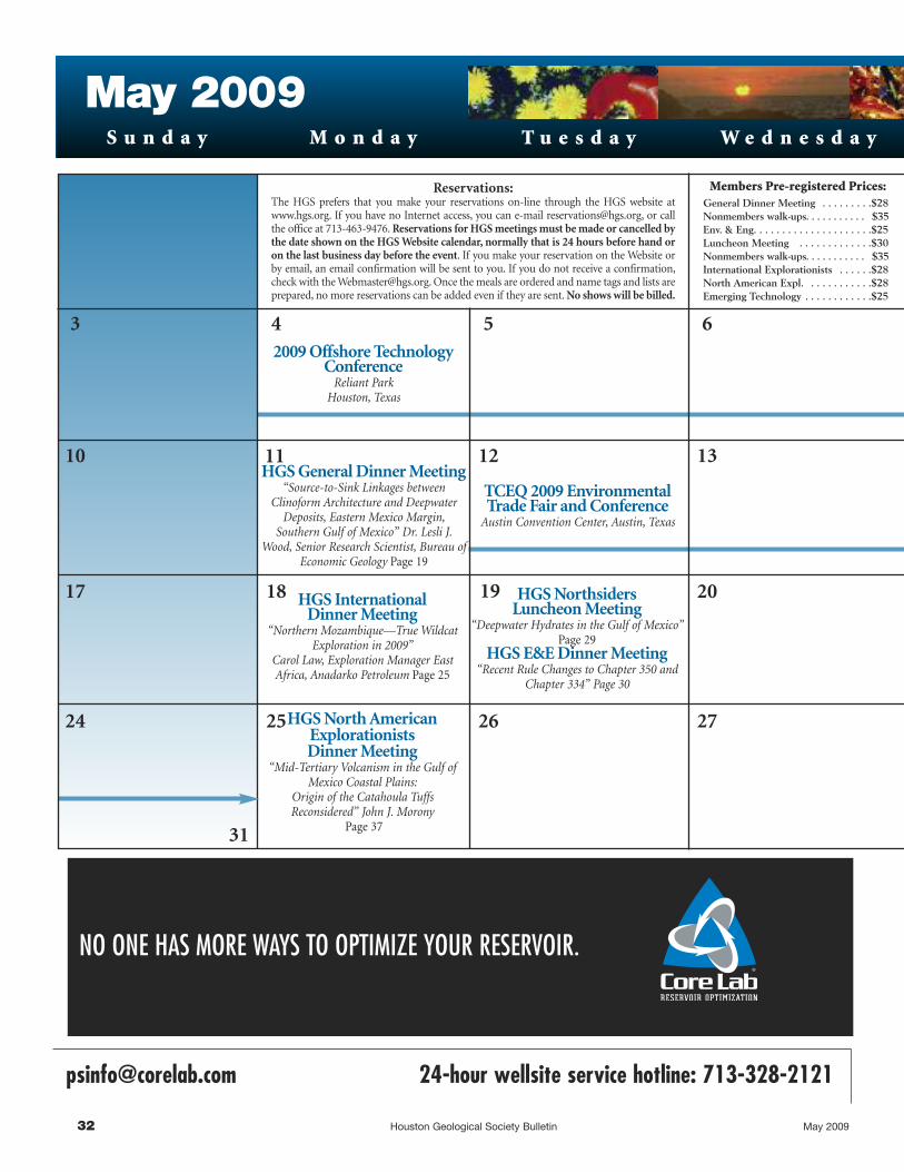
2009 Offshore TechnologyConference
Reliant ParkHouston, Texas
TCEQ 2009 EnvironmentalTrade Fair and Conference
Austin Convention Center, Austin, Texas
Members Pre-registered Prices:General Dinner Meeting . . . . . . . . .$28Nonmembers walk-ups. . . . . . . . . . . $35Env. & Eng. . . . . . . . . . . . . . . . . . . . .$25Luncheon Meeting . . . . . . . . . . . . .$30Nonmembers walk-ups. . . . . . . . . . . $35International Explorationists . . . . . .$28North American Expl. . . . . . . . . . . .$28Emerging Technology . . . . . . . . . . . .$25
Reservations:The HGS prefers that you make your reservations on-line through the HGS website atwww.hgs.org. If you have no Internet access, you can e-mail [email protected], or callthe office at 713-463-9476. Reservations for HGS meetings must be made or cancelled bythe date shown on the HGS Website calendar, normally that is 24 hours before hand oron the last business day before the event. If you make your reservation on the Website orby email, an email confirmation will be sent to you. If you do not receive a confirmation,check with the [email protected]. Once the meals are ordered and name tags and lists areprepared, no more reservations can be added even if they are sent. No shows will be billed.
HGS International Dinner Meeting
“Northern Mozambique—True WildcatExploration in 2009”
Carol Law, Exploration Manager EastAfrica, Anadarko Petroleum Page 25
HGS North AmericanExplorationistsDinner Meeting
“Mid-Tertiary Volcanism in the Gulf ofMexico Coastal Plains:
Origin of the Catahoula TuffsReconsidered” John J. Morony
Page 37
HGS Northsiders Luncheon Meeting
“Deepwater Hydrates in the Gulf of Mexico”Page 29
HGS E&E Dinner Meeting “Recent Rule Changes to Chapter 350 and
Chapter 334” Page 30
S u n d a y M o n d a y T u e s d a y
May 2009W e d n e s d a y
3
10
6
11
19
262524
13
[email protected] 24-hour wellsite service hotline: 713-328-2121
NO ONE HAS MORE WAYS TO OPTIMIZE YOUR RESERVOIR.
4 5
18 20
31
27
12
17
HGS General Dinner Meeting “Source-to-Sink Linkages between
Clinoform Architecture and DeepwaterDeposits, Eastern Mexico Margin,
Southern Gulf of Mexico” Dr. Lesli J.Wood, Senior Research Scientist, Bureau of
Economic Geology Page 19
32 Houston Geological Society Bulletin May 2009

T h u r s d a y
1 2
8
15
30
GEOEVENTS
23
S a t u r d a yF r i d a y
97
Collarini Energy Staffing Inc.Full–Time and Temporary Exploration and Production Personnel
Geoscience � Facilities � Drilling � Production � Reservoir Engineers � Landmen � Management
Procurement � Information Technology � Health and Safety � Accounting � Administrative Support
11111 Richmond Avenue, Suite 126 www. collarini.com 4200 South I-10 Service Road, Suite 230 Houston, Texas 77082 Metairie, Louisiana 70001 Phone (832) 251-0553 Phone (504) 887-7127
Upcoming GeoEventsJune 7 – 10AAPG Annual ConventionDenver, Colorado
June 209th Annual GSH / HGS SaltwaterTournamentTackle Box Storage & Fish SpotMarina, Texas City
June 21 – 29HGS Grand Canyon Field Trip
June 2726th Annual HGS Skeet ShootGreater Houston Gun Club, MissouriCity
July 17SIPES Independent’s DayCelebrationShrimp Boil at Big Woodrow’s
August 13HGS Technofest
August 27 – 28Summer NAPE ExpoHouston, Texas
September 9 – 10PESGB / HGS Africa Conference2009London
September 27 -29 59th Annual GCAGS-GCSSEPMConventionShreveport, Louisiana
October 25–30SEG International Exposition and79th Annual MeetingHouston, Texas
1614
28 29
21 22SIPES Luncheon“Corpus Christi Bay - Another 3-D
Success”Robert M. Rice, Principal Geologist,
Royal Exploration Co., Inc. Petroleum Club
Page 41
HGS Continuing Education “Reservoir Engineering Tools for
Geoscientists” John R. Farina, Petroleum Engineer
HPAC Annual GeneralMeeting and Luncheon
Houston Racquet ClubPage 60
NOWyou can make
your reservations on-line at
www.hgs.org
May 2009 Houston Geological Society Bulletin 33

34 Houston Geological Society Bulletin May 2009

May 2009 Houston Geological Society Bulletin 35
HGS Environmental & Engineering Dinner continued from page 30 ____________________________________________________________________________
HGS Environmental & Engineering Dinner Meetin
g
Senior Engineer, the Technical Services Function Lead, and the
Rules Liaison for the PST Reimbursement & Technical Services
Section in the Remediation Division. Contact information:
Telephone: 512/239-5755. E-mail: [email protected]
PAUL LEWIS graduated from Widener College with a B.S. degree in
management in 1972. After two years of military service in Texas,
he entered the University of Texas at Austin and completed an
M.A. degree in geology in 1978. He joined the Texas Department
of Water Resources in 1979. Duties with the TCEQ and predecessor
agencies over the course of 30 years have varied between technical
and management positions. His current assignment as a technical
specialist in the Remediation Division includes developing
guidance and training for the Texas Risk Reduction Program rule.
He is a licensed professional geoscientist in Texas. Contact
i n f o rma t i on : Te l e phon e : ( 5 1 2 ) 2 3 9 - 2 3 4 1 . Ema i l :
UNIVERSITY OF HOUSTON - DEPARTMENT OF EARTH & ATMOSPHERIC SCIENCES
PETROLEUM GEOPHYSICS SHORT COURSE PROGRAM HOUSTON, TEXAS
SS UU MM MM EE RR 22 00 00 99 SS CC HH EE DD UU LL EE
Seismic Wave and Ray Theory May 4 - 8 (8:00am – 4:30pm) JERRY SCHUSTER
Application & Interpretation of Converted Waves May 11 - 15 (8:00am – 4:30pm) ROB STEWART
JAMES GAISER
Rock & Fluid Physics May 18 - 22 (8:00am – 4:30pm) JOHN CASTAGNA
Reservoir Geophysics May 25 - 26 (8:00am – 4:30pm)
May 27 (8:00am – 12:00pm) JOHN CASTAGNA
3D Seismic Interpretation I May 27 (12:00pm – 4:00pm)
May 28 – 29 (8:00am – 4:30pm) CHRIS LINER
3D Seismic Interpretation II June 1 - 5 (8:00am – 4:30pm) FRED HILTERMAN
Geophysical Data Processing June 8 – 12 (8:00am – 4:30pm) CHRIS LINER
Seismic Migration June 15 - 19 (8:00am – 4:30pm) HUA-WEI ZHOU
EM June 23 - 24 (8:00am – 4:30pm)
June 24 (8:00am – 12:00pm) KURT STRACK
LEON THOMSEN
Seismic Attributes for Reservoir Carbonates June 24 (12:00pm – 4:00pm)
June 25, 26, 29 & 30 (8:00am – 4:30pm) KURT MARFURT
All classes will be held at the University of Houston Main Campus. For more information about enrollment and cost,
please visit: http://www.geosc.uh.edu or contact us at (713) 743-3402
V O T EBe sure to cast your vote in the HGS election by May 10, 2009.

36 Houston Geological Society Bulletin May 2009

HGS North American Explorationists Dinner Meetin
g
The Oligocene Catahoula
Formation is currently
believed to be a product of
exclusively exogenic processes
principally fluvial in nature.
All volcaniclastics of the
Catahoula, of whatever age
(Eocene to Miocene), size (fine
ash to boulders), chemistry
(basalt to rhyolite), variety
(accretionary lapilli to mud
flow tuffs), location (Mexico
to Alabama) or magnitude of
deposition (up to 1,000 feet
thick), are assumed to be
derived exclusively from a
distant volcanic provenance:
the Trans-Pecos or the Sierra
Madre Occidental or both.
However, Thomas L. Bailey’s
long-forgotten 1924 hypothesis—
that the Catahoula Formation
is a consequence of local
volcanism, and thus constitutes
a volcanic terrain rather than
a sedimentary formation,
needs to be revisited. In 1977,
a massive igneous intrusion
was identified subjacent to
Catahoula volcaniclastics in
Live Oak and McMullen
Counties, Texas where surface
remains of tuff rings have
recently been identified. These
discoveries provide conclusive
evidence of past endogenic
forces in the region. Likewise,
Monday, May 25, 2009Westchase Hilton • 9999 WestheimerSocial Hour 5:30-6:30 p.m. • Dinner 6:30-7:30 p.m.Cost: $28 pre-registered members; $35 for non-members & walk-ups;Emeritus/Life/Honorary: $14; Students: FREE
To guarantee a seat, you must pre-register on the HGS website and pre-pay witha credit card. Pre-registration without payment will not be accepted. You may still walk up and pay at the door, if extra seats are available.
John J. Morony
HGS North American Explorationists Dinner Meeting
May 2009 Houston Geological Society Bulletin 37
Mid-Tertiary Volcanism in the Gulf of Mexico CoastalPlains:
Origin of the Catahoula Tuffs Reconsidered
Pyroclastic surge deposit, Catahoula tuff, along US 281, 7.5 miles N of Three Rivers, Texas. Previously identi-fied as an ash-fall originating from the Trans-Pecos and/or the Sierra Madre Occidental.
Chalk bluffs, McMullen County, Texas. These exposures are identified as the fragmented remains of rampartsof tuff rings; a consequence of hydrovolcanism. The prevailing opinion is that they are simply accumulation ofreworked air-fall deposits that originated in the Sierra Madre Occidental. HGS North American Dinner continued on page 39

38 Houston Geological Society Bulletin May 2009
AS GOOD AS OUR WORDTAP INTO OUR RESERVOIR
EXPERIENCE For over a half-century Dawson has helped its clients succeed. In bothseismic acquisition and processing, we deliver high quality data that gets clear-cut results.From field equipment to software, we put the latest technologies into the hands of seasonedprofessionals who have geophysical knowledge specific to all major U.S. basins. Decades ofacquiring data and imaging objectives to provide total subsurface picture. That's what ourexperience gives you.practice every day.
www.dawson3d.com508 West Wall, Suite 800
Midland, Texas 79701432-684-3000
800-D-DAWSON
Houston, Texas 713-917-6772
Denver, Colorado 303-409-7787
Oklahoma City, Oklahoma 405-848-7512
Michigan 248-446-9533
Plann ing • Des ign • Acquis i t ion • Process ing • Resu lts

HGS North American Explorationists Dinner Meetin
gHGS North American Dinner continued from page 37 ____________________________________________________________________________________________________________________
the igneous intrusion may be the heat source for the adjacent
Wilcox geothermal corridor. Subsequent circulation of
hydrothermal fluids accompanying hydrovolcanism provides a
plausible explanation for the origins of the uranium deposits
currently believed to have been ash-expressed from the Sierra
Madre Occidental a thousand kilometers distant. The breeching
of the basement rock is suggested to have
been along the hinge line of the thick and
thin transitional crusts in close proximity
to the Stuart City Trend and coeval with
and possible tectonically related to plate
movements to the west and northwest.
Rejection of a valid scientific hypothesis,
as presented by Bailey, coupled with
non-recognition of the rules of parsimony
(Occam’s razor), customarily employed in
scientific expositions, has obscured an
understanding of the geology of the Gulf
Coastal Plain. If the Catahoula volcaniclastics
are other than local in origin one must
ask—what is the geological evidence? �
Biographical SketchJOHN J. MORONY
earned a B.S. in biol-
ogy from Texas A &
M University in 1960
and an M.S. in biology
from Louisiana State
University, Baton
Rouge in 1966. His
earlier professional
career was in associat ion with the
American Museum of Natural History in
New York City, New York and the Museum
of Natural Science, Louisiana State
University, Baton Rouge. Both positions
entailed collecting expeditions to the
Neotropics. Mr. Morony also spent time at
Columbia University, New York on grants
devoted to avian anatomy and systematics.
As a consequence of extensive field work
in the Neotropics, Mr. Morony became
interested in potential influences of vol-
canism on biogeography. This necessitated
a sound foundation in the fundamentals
of geology. He attended a two-week field
course on volcanism in 1994 taught by
Michael Cummings, geologist at Portland
State University, which served as a formal introduction into
the subject. Mr. Morony conducted self-directed studies with
much counseling from Kenneth Wohletz, geologist at Los Alamos
and a l ead ing author i t y on hydrovo lcan i sm. Emai l :
May 2009 Houston Geological Society Bulletin 39
Ramparts of a tuff ring in the wall of the Stoelje uranium quarry, Karnes County, Texas. Thelower bed is tuffaceous clay, interspersed with accretionary lapili that was wet at the time the nextpyroclastic surge was deposited on top resulting in soft sediment deformation of both.“Hydroplastic slickenslide” can be found on the upper surface of the clay in response to gravita-tional instability resulting from syndepositional sliding or shifting of the upper bed. The high heatof the latter surge deposit served to bake the upper portion of the underlying tuffaceous clay.
Walls of the Sickenious uranium quarry, Karnes County, Texas. Pyroclastic surge deposits in amarine environment surmounted by a bed of lignite subsequently subject to liquefaction.Subsidence was followed by additional marine deposits.
40 Houston Geological Society Bulletin May 2009
Killer whales produce whistles, clicks, pulsed calls, low-frequency pops and jaw claps for two
overlapping functions—to communicate and echolocate.
For years PGS has been communicating closely with operators in exploration basins worldwide
to help locate new prospects, to expand production from existing ones and to lower finding
and development costs. Recent significant successes from our depth imaging teams are
giving geoscientists clear images by using state-of-the-art migration algorithms and advanced
velocity model building workflows. To find out more about the bottom line benefits of PGS
data processing, please contact Frank Dumanoir at (713) 509-8354.
A clearer image www.pgs.com

May 2009 Houston Geological Society Bulletin 41
Sabco Oil & Gas Corporation and Royal Oil & Gas Corporation formed a partnership in 1997 to exploit state leases in Corpus
Christi Bay that were held for production by Sabco with the remnants of excellent Frio production discovered between 1952 and
1970. The partnership was consummated on the day that 80 square miles of Western Geophysical speculative 3-D seismic survey data
in western Corpus Christi Bay were released. The partnership concentrated on two fields, East Corpus Christi and Encinal Channel,
which are downthrown to a large growth fault that extends across the mid-section of the bay.
The two fields are located on a shale-cored ridge which is perpendicular to the growth fault. East Corpus Christi Field is closest to the
fault. At the time the partnership was formed, it had produced 90 billion cubic feet (BCF) of gas from Upper Frio sands aged from
Marginulina (approximately 6,000 feet subsea) through Nonion struma (approximately 9,000 feet subsea). The field is non-geopressured
and structurally simple. The sands range from 20 to 50 feet thick with thin shale interbeds and, with the exception of the Marginulina,
the trapping mechanism is thus anticlinal closure. Encinal Channel
SIPES Luncheon MeetingCorpus Christi Bay - Another 3-D Success
Robert M. Rice, Principal Geologist, Royal Exploration Co., Inc.
SIPES Luncheon Meetin
g
Thursday, May21, 2009Houston Petroleum Club in the Discovery Room, 800 Bell St. (downtown Houston). Social 11:15 AM, Luncheon 11:45 AM
Reservations Required: Make reservations by telephone (713-651-1639), fax (713-951-9659), website (www.sipes-houston.org), or [email protected] to B. K. Starbuck-Buongiorno by 12:00 noon on Tuesday preceding the meeting. You can now sign up for the meeting online atwww.sipes-houston.org, but payment is still required by regular mail or at the door.
Cost: $30 for SIPES Members and Chapter Affiliates who register by 12:00 Noon Tuesday; $35 for new registrations at the door. The price for guests, non-members and walk-ins is $35. No-shows will be billed.
SIPES Luncheon continued on page 43

THIRD ANNOUNCEMENT THE 8TH PESGB / HGS CONFERENCE ON AFRICAN E & P
Africa: New Concepts for the Oldest Continent
QE II Conference Centre, London, 9 - 10 September 2009
Alternating between London and Houston, this annual conference has established itself as the primary technical E & P conference on Africa for
Operators, Consultants, Governments and Academics.
Oral programme to include about 25 high quality presentations with an associated large poster display. A preliminary programme will be on the PESGB website from April onwards. A few poster slots may be available, please send abstracts asap to [email protected]
Papers on this preliminary programme (subject to permissions) include: * Deepwater Plays in Gulf of Sirt (BP) * New Plays in Sirt Basin (Shell) * Ghana Discoveries (Kosmos) * Albert Basin (Tullow, Heritage)
* South Atlantic Conjugate Margin and Turbidite Play Prediction Studies (Consultants) * New Plate Tectonic Models and Regional Tectonics (Academics) * East African Regional Petroleum Systems and New Plays *
2009 Conference Committee: Ray Bate (Chairman), Duncan MacGregor & Richard Dixon (Technical Co-ordinators),
Kevin Dale (London) and Al Danforth and Ian Poyntz (HGS, Houston).
Image courtesy of Fugro NPA and Surestream Petroleum : Lake Tanganyika, Neogene rift basin exploiting Permian rift trends and PanAfrican lineaments, composite topographic and satellite gravity image
Pre-Registration is now available at an Early Bird discounted rate of £250 for PESGB/HGS/Geol Soc. Members and £300 for Non-Members. Please complete the Registration Form and return to the
To book an Exhibition Booth please complete the Booth
For Sponsorship Opportunities please contact Rebecca at
Ear
lyS
pons
ors
42 Houston Geological Society Bulletin May 2009

Field is southeast of East Corpus Christi Field and becomes the dominant structural
feature with depth, starting at approximately 9,000 feet subsea at the base of the Upper
Frio Nonion struma section and producing down to the Middle Frio Discorbis “D” at
approximately 12,500 feet subsea. The East Corpus Christi Field has produced in excess of
150 BCF of gas with most of the sands being geopressured and faulting becoming increasingly
complex with depth. The sands vary from 20 to 150 feet in gross thickness with the shale
intervals being much more abundant and thicker than at East Corpus Christi Field. The
thicker shales provide the seal for the upthrown fault closures and, when combined with
the complex fault pattern, are ideal candidates for 3-D seismic surveys.
The entire two-field complex was discovered and exploited prior to the advent of high
quality 2-D seismic data, leaving a prospect with “major-league” reserves and no modern
seismic data. Encinal Channel Field also had a key well, the Gulf #2 State Tract 48, which
had produced 2.6 BCF of gas from the Middle Frio M-4 Sand at 10,586 feet subsea prior to
watering out. The well had a water contact that, by subsurface control was known to be 300 feet low to the top of the structure. There
appeared to be 700 acres of unproduced prospective area between this well and the next highest producing well. The 3-D seismic data
interpretation confirmed the existence of several fault blocks in the 700-acre target area. The Sabco/Royal partnership drilled these fault
blocks first, followed by fault blocks identified using 3-D seismic data, eventually drilling 17 successful wells and 3 dry holes. This
drilling program resulted in peak production of 60 million cubic feet per day of gas and additional cumulative production to date of
approximately 100 BCFE. In early 2009, gas production was still 15 million cubic feet per day. Production in Corpus Christi Bay was
thus brought back to life and can be added to the long list of 3-D success stories. �
May 2009 Houston Geological Society Bulletin 43
SIPES Luncheon continued from page 41 ________________________________________________________________________________________________________________________________________________________
SIPES Luncheon Meetin
g
The thicker shales provide
the seal for the upthrown
fault closures and, when
combined with the complex
fault pattern, are ideal
candidates for 3-D seismic
surveys.
SIPES Luncheon continued on page 47

44 Houston Geological Society Bulletin May 2009
David Childers, ph: 281-872-5022, e-mail: [email protected] Northchase, Suite 1600, Houston, TX 77060
Cheated, Mistreated,Pushed Around?
Have you been cheated, mistreatedor somehow deprived of yourshare of a deal, working interestor royalty? If so, give me a call. I have twenty five years experienceas a working interest and royaltyowner in the oil and gas businessto go along with thirty five yearsof court room experience. You donot pay anything unless I win.
Robert A. Chaffin
CHAFFIN & STILES4265 San Felipe, Suite 1020
Houston, Texas 77027
(713) [email protected]

May 2009 Houston Geological Society Bulletin 45
The Earth Science World website calls itself the “Gateway to
the Geosciences.” The homepage has a clean look with large
white areas and no advertisements. The homepage banner has
bold graphics, four photographs of geologic features, and links to
the five primary subject areas of the website. The content on the
homepage is lean with only a few images and clickable links in
the body that mostly duplicate the links in the banner. At the bot-
tom of the homepage are some additional links that connect to
the parent American Geological Institute website and related
webpages.
The American Geological Institute (AGI), based in Alexandria,
Virginia, is a nonprofit federation of 45 geoscientific and profes-
sional associations that represents more than 120,000 geologists,
geophysicists, and other earth scientists. Among the member
societies are the American Association of Petroleum Geologists,
the American Institute of Professional Geologists, the Association
of Environmental & Engineering Geologists, and the Society of
Exploration Geophysicists. Founded in 1948, AGI provides infor-
mation services to geoscientists, serves as a voice of shared
interests in the profession, plays a major role in strengthening
geoscience education, and strives to increase public awareness of
the vital role the geosciences play in the use of resources, mitiga-
tion of natural hazards, and the health of the environment. The
website states that Earth Science World is a service of AGI and a
place to explore interests in the earth sciences.
The five main links from the homepage are Book Center, Image
Bank, Earth Science Week, Geoscience Careers, and Games.
During the preparation of this article, the webpage for the Book
Center was unavailable but visitors were asked to “check back
Earth Science Worldwww.earthscienceworld.org
Michael F. Forlenza, P.G.
Geologic Website of the Month continued on page 46
Geologic Website of th
e Month

46 Houston Geological Society Bulletin May 2009
Geologic Website of th
e Month
soon.” The Image Bank, designed to provide quality geoscience
images to the public, educators, and the geoscience community, is
fairly impressive. With over 6,000 geology-related photographs
and diagrams, it is one of the largest sources of earth science
imagery available on the Internet. Sophisticated search functions
allow the visitor to browse the archive of
images by category, by geologic feature,
by location, or by keywords. A new fea-
ture also allows searching by geographic
coordinates.
The Earth Science Week link opens the
www.earthsciweek.org website which
has a similar appearance to the Earth
Science World website. The Earth
Science Week webpage has numerous
links to features and resources related to
annual activities surrounding Earth
Science Week that is held in October to
encourage people to explore the natural world and learn about
the geosciences. These features and resources include a newsletter,
teaching materials, class room activities, contests, information on
scholarships and internships, photograph gallery, and a calendar
of events.
The Geoscience Career link connects to the AGI geoscience work-
force page. This page provides some useful information for
students considering studies or careers in the geosciences. On the
Data and Reports page are links to original reports pertaining to
the career outlook for professionals in the geosciences. These AGI
reports include the March 2009 “Effects of the Global Economic
Crisis on Geoscience Departments” concerning the viability of
academic programs and the “Status of the Geoscience Workforce
Report” released in February 2009. This workforce report is a fas-
cinating, extensively researched, and comprehensive evaluation of
the geoscience profession. The workforce report is based on
copious original data collected by the AGI as well as on data
from existing sources such as federal agencies, professional
organizations, and industry. The report synthesizes the avail-
able data and presents an examination
of subjects ranging from the supply
and training of new geoscience stu-
dents, to workforce demographics and
employment projections, to trends in
geoscience research funding and eco-
nomic indicators. The report is a
worthwhile read to see where our pro-
fession is headed. And, for people who
like graphs and bar charts, the report is a
treasure. Also useful is the list of the
links to the Related Sites page for geo-
science societies and geosciences
career-related websites.
A text box on the Earth Science World homepage with a graphic of
Geologic Website of the Month continued from page 45 __________________________________________________________________________________________________________
This workforce report is a
fascinating, extensively
researched, and comprehensive
evaluation of the geoscience
profession…for people who like
graphs and bar charts, the
report is a treasure.

a nautilus shell connects the visitor to and “Interactive Geologic
Time Scale.” This is a disappointing feature. After selecting a time
period, a rather simple geologic time scale appears with the select-
ed time interval slightly highlighted. In the age of stunning
computer graphics, this is hardly an interactive feature.
Do not miss the Games section of the website. Clicking on Games
in the banner or on photograph of the pump jack near the bot-
tom of the homepage will open the virtual oil well interactive
game. Running the game requires Java software which can be
downloaded. The interactive virtual oil well game is the primary
reason to visit the website to test your hydrocarbon exploration
skills and your luck in the swamps of southern Louisiana. The
game provides a back story: your late Aunt Thibodeaux pur-
chased the mineral rights to an eight mile square of land where
there is a good chance that oil can be found. She has also left you
$2,000,000 and mineral rights to that land. You must use this
inheritance to explore for gas or oil on that land.
Just as in non-virtual hydrocarbon exploration, everything costs
money. Hiring consultants, shooting seismic, drilling, and well
completions will cut into your aunt’s stake so be sure to budget
wisely. You can identify potential exploration targets after acquir-
ing one, a few, or several seismic lines depending on how
confident you feel about your target. As drilling progresses, you
can review the mud logger’s reports to decide whether to drill
deeper or complete the well. Tension mounts as the drill bit
encounters only brine-filled sands and your funds disappear. I
will not provide any hints on where to look for the potential rich-
es that may lie under that swamp land. But I will say that I drilled
several dusters before making my fortune.
Overall, the content of the “Gateway to the Geosciences” is some-
what spare and the navigation somewhat quirky. It is sometimes
difficult to tell that a link has opened a different website, from
where, you cannot return to the homepage without using the
Back button. Still, a visit to the Earth Science World website is
worthwhile for the lovely image database, the recent and compre-
hensive reports on the geosciences profession, and the amusing
interactive oil exploration game. �
May 2009 Houston Geological Society Bulletin 47
Geologic Website of th
e Month
Biographical SketchROBERT M. RICE has worked for over 30 years as a petroleum geologist. He began his career with
Texaco in New Orleans where he worked for four years as an offshore geologist in the Gulf of Mexico.
He moved to Corpus Christi, Texas to work the onshore Texas coast for Texas Oil and Gas and later for
three family owned companies: Edwin L. Cox, Suemaur Exploration, and Royal Exploration
Company. At Royal, he was the principal geologist for the Corpus Christi Bay project. He subsequently
returned to offshore work and has been the principal geologist for Royal's Gulf of Mexico exploration
program.
Mr. Rice graduated summa cum laude from Denison University with a B.S. degree in geology and
earned an M.S. degree in geology from the University of Southern California.
SIPES Luncheon continued from page 41 ________________________________________________________________________________________________________________________________________________________
SIPES Luncheon Meetin
g
Contract and Full Time Exploration and Production StaffGeoscience, Management, Reservoir Engineers, Landmen,
Information Technology, ProductionWe can provide you with the RIGHT people with the RIGHT skills and
the RIGHT experience at the RIGHT price, time and location!Why spend all your scarce management time looking for staff when we
can do it for you? Founded in 1999, GeoExperts is staffed and led by E&Pprofessionals with decades of experience in the worldwide oil industry
Tel: 713-953-0823, ext. 13, Fax: 713-2953-1642(we also have offices in Canada, London and West Africa)
www.geoexperts.com

48 Houston Geological Society Bulletin February 200948 Houston Geological Society Bulletin May 2009

On February 22, 2009, members of Houston Geological
Society and Houston Gem and Mineral Society (HGMS)
put together Earth Science Week’s free, public High Island field
trip. The trip, which was originally scheduled for October 2008,
had been cancelled due to Hurricane Ike. More than 50 people
joined the trip, including HGS members, HGMS members,
professors, instructors, students, and interested families. We had
strong participation from three local universities: College of the
Mainland, Lamar University, and St. Thomas University.
Participants learned about the local salt domes, hydrocarbon
production in the area, beach and storm processes, the aftermath
of Hurricane Ike, and the big activity of the day, collecting
Pleistocene fossils from the Beaumont Formation. Most of the
sand dunes had been cleaned off the beach by Hurricane Ike,
exposing large expanses of the Beaumont shale. With the north
wind blowing the water out and the low tide, the conditions were
perfect for finding the 2 to10-million year-old bison and
mammoth bones exposed near the beach front.
After setting up base camp on the beach where Highway 87 and
Highway 124 intersect just south of the small town of High
Island, we had group discussions about the salt domes and hydro-
carbon production in the area. Several subsurface maps and
cross-sections described the hydrocarbon traps and structure.
Neal Immega brought a sample piece of core from the High
Island field showing the cap rock with sulfur deposits. We could
look across the highway and see the ring of pump jacks that sur-
round the small town of High Island that sits atop the salt dome.
High Island is the highest point on the upper Texas gulf coast at a
little more than 40 feet above sea level. We all agreed that it still
was not a place we would want to be during a storm.
Dr. Donald Owen of Lamar University brought a composite aeri-
al photograph of a large section of Bolivar Peninsula showing
Hurricane Ike’s effects on the shoreline. We discussed the obvious
washover channels cut into the landscape and talked about the
channel fan deposits on the beach side. These were created when
the water from the storm surge started draining back seaward. We
could not help but notice also the destruction to homes and
property done by the storm. We looked at the USGS website aerial
photographs from before and after the storm. The photographs
showed that dune material was eroded from the beach and was
then deposited in the lagoon.
With most of the sand dunes gone, it was easy to drive along the
beach and see the exposed Beaumont Formation. The salt diapir
has pushed up the underlying layers of rock and exposed the
Pleistocene Beaumont shale for several miles along this beach.
The dark brown mud is very different from the typical beach
sand seen on Galveston Island and the Bolivar Peninsula. This
High Island Field TripHigh Island Field Trip 2009
Earth Science Week had a Mammoth Field Trip to High Island
Martha McRae
Beaumont Formation in the foreground and a pump jack in the back-ground Bison tooth
May 2009 Houston Geological Society Bulletin 49
High Island Field Trip 2009 continued on page 51

50 Houston Geological Society Bulletin May 2009

May 2009 Houston Geological Society Bulletin 51
mud contains well-preserved bison and mammoth teeth and
bones. After a brief introduction of what to look for, everyone
headed out with buckets and shovels and went fossil-hunting
along the beach. Some of the early arrivals that morning had
started looking for fossils before we got there and had found a
whole bison leg bone. That, of course, got everyone excited. While
not nearly as exciting, fossilized worm burrows and iron oxide
concretions were very common. After about three hours, the
die-hard collectors came wandering back to base camp with some
real prizes to share and identify. Several bison leg bone fragments
were found as well as a four-inch-long horse tooth and a
well-preserved, nearly intact bison tooth. The big find of the day
was a mammoth tooth weighing around eight pounds that was
found by Joe Coker right at the shoreline about two miles down
the beach from base camp.
As in most successful and fun geology field trips, the day was
filled with many impromptu discussions, ranging from possible
causes for the massive destruction of property behind the geotube
(sand-filled fabric tube used as a barrier for dune protection), to
the best way to recognize a fossilized worm burrow and not
recent dog poop without picking it up. We could not have asked
for better weather: calm north wind and clear blue skies with
temperatures reaching the low 70s. All in all, this was a wonderful
trip filled with great hands-on geology and some pretty fantastic
fossil finds. And just think, all of this is right in our own
“back yard.” �
High Island Field TripHigh Island Field Trip 2009 continued from page 49 _______________________________________________________________________________________________________________________
Group presentation
Worm burrows
Mammoth Tooth and Joe Coker
Horse tooth and bison bone
Mammoth tooth upclose

52 Houston Geological Society Bulletin May 2009
Technofest is Back!Westin Galleria—August 13, 2009—2:00p–8:30p
Afew years back, the Houston Geological Society came up
with an idea for a summertime event that would gather the
best of new technologies and a crowd of interested geoscientists.
That event was Technofest! Originally held at the Westchase
Hilton, it was an instant hit. As such, it maxed out the parking,
air-conditioning and space at the Hilton.
Now Technofest is to be held in the Westin Galleria. The
Woodway Hall at the Westin is over 21,000 square feet of carpeted,
air-conditioned space just waiting for Vendors, Companies and
Deal Sellers to share their information! In addition, because it is
part of the Galleria, there are 8500 FREE parking spaces in close
proximity.
There is going to be 58 - 10’ x 10’ spaces. Booth rental is only
$400 and includes two admissions to the event. Ticket prices for
the event are $10 for HGS Members and $15 for non-members,
and will be the same at the door. The admission also includes one
free drink ticket! We are anticipating booth spaces will sell out
quickly – so it is first come-first served! A layout plan is included
in this Bulletin. Vendors are allowed to set up between 8:00a and
Noon, and tear-down will be after 8:30p to 11:00p.
Of course Sponsorship opportunities are available for food and
beverages. This year we have lowered the cost of sponsorship so
that more companies can participate and it won’t hurt the pock-
etbook as much! Sponsorships can be made at the PLATINUM
LEVEL - $1000, GOLD LEVEL - $500, SILVER LEVEL - $250
AND BRONZE LEVEL - $100. Sponsors will be give top billing at
all refreshment stations and in the registration area of the
Woodway Hall. Finger foods and cash bars will be scattered
around the Hall, so there should be no long lines! There is also an
opportunity for a Sponsor to host the Popcorn Machine. They
could have their logos or names on the popcorn bags! The cost
for the Popcorn Sponsorship is approximately $1000 (rental and
popcorn – does not include bag printing).
Also needed are volunteers! The HGS is expecting a huge turnout
for this event, and help will be needed with registration and ven-
dor setup. Volunteers get free admission!
For more information, please contact Deborah Sacrey at
713-468-3260 or [email protected]. Other members of
the committee are Bonnie Milne – [email protected]
and Jim Grubb – [email protected] �

May 2009 Houston Geological Society Bulletin 53
AGI Government Affairs Monthly Review (February2009)Economic Stimulus Contains Support for Geoscience
On February 13, 2009, Congress passed H.R. 1, the American
Recovery and Reinvestment Bill of 2009, and President Obama
signed it into law on February 17. The law allocates $787 billion
in supplemental appropriations, tax credits, tax cuts, and other
measures over a one to two year period. The goal of the law is to
create and save 3.5 million jobs, provide tax cuts to 95% of
American workers, invest in infrastructure, restore science and
innovation as integral parts of solving societal issues, and rapidly
invest to revive a struggling economy. No House Republicans
supported the bill and only three Senate Republicans voted for it.
Within H.R. 1, significant funding is designated for science, tech-
nology, and infrastructure. Geoscience-related federal agencies
receiving supplemental appropriations include the Department
of Energy ($23.1 billion), the Environmental Protection Agency
($7.2 billion), the U.S. Army Corps of Engineers ($4.6 billion),
the National Science Foundation ($3 billion), the National
Aeronautics and Space Administration ($1 billion), the National
Oceanic and Atmospheric Administration ($836 million), the
National Institute of Standards and Technology (NIST) and the
U.S. Geological Survey ($140 million).
Federal agencies are now in the process of writing out plans for
spending the supplemental appropriations and sending these
plans to Congress for approval. Although agencies have 60 days to
submit plans, many are likely to submit their plans sooner so they
can get the funds distributed and move projects forward. In many
cases, Congress worked with agencies on the bill beforehand and
has provided funding for projects that were ready to go.
National Science Foundation Director Arden Bement released a
statement that said, “The $3 billion provided to NSF will go
directly into the hands of the nation's best and brightest
researchers at the forefront of promising discoveries, to deserving
graduate students at the start of their careers, and to developing
advanced scientific tools and infrastructure that will be broadly
available to the research community.”
New Energy Secretary Steven Chu announced a special team to
conduct a complete restructuring of the dispersal of direct loans,
loan guarantees, and funding in the stimulus. Visit agency web
sites or contact agency officials for more details.
New Interior Secretary Ken Salazar is concerned that he does not
have enough upper-level positions filled to deal with the $3 bil-
lion stimulus given to his department. Nonetheless, each major
office and service has identified a prioritized list of projects that
are ready to go. For example, the National Park Service identified
$9 billion worth of projects that are backlogged only because of
insufficient funds. Concerns remain that some projects might be
delayed by National Environmental Policy Act (NEPA) reviews.
More details about geoscience-related supplemental appropria-
tions are available from an AGI Special Update at:
http://www.agiweb.org/gap/legis111/update_stim0209.html
The full text of H.R. 1 can be found at: http://thomas.loc.gov/cgi-
bin/bdquery/z?d111:h.r.0001:
For information about how the funds are being used, timelines
for reporting spending, and other details, see www.recovery.gov
Congress Considers Tougher Measures for Coal Ash Pit
Disposal
The December 2008 spill of 5.4 million cubic yards of coal ash
sludge into residential areas and the Emory River near Kingston,
Tennessee after a break in a containment pond wall prompted
Congress to consider modifying current coal ash disposal regula-
tions. The Coal Ash Reclamation, Environment, and Safety Act of
2009 (H.R. 493), proposed by House Natural Resources
Committee Chairman Nick Rahall (D-WV), would require
mandatory design and performance standards on coal ash
impoundments to make them consistent with similar enclosures
used for slurry waste in the coal mining industry. New require-
ments proposed in the bill include a geotechnical analysis of an
embankment’s foundation area, an assessment of past surface
mining activity at the proposed location of a structure, and
mandatory inspection by a certified engineer during and after
construction.
“We need to learn a lesson from what happened at Kingston. This
issue cannot be ignored,” stated Rahall at a February 12, 2009
subcommittee hearing. The bill was challenged by Congressman
Doug Lamborn (R-CO) for not including a funding mechanism
for enforcement of the new standards. The bill currently calls for
a six-month time frame for implementation, although John
Craynon of the Department of Interior’s Office of Surface
Mining said it was unlikely the new standards could be in place in
that short of a time-frame. Despite the potential delay, Rahall
stated he was flexible with the time-frame and plans to bring the
Government UpdateGovernment Update
Henry M. Wise, P.G. and Arlin Howles, P.G.
The Government Update provides information on rules, regulations, policy, and meetings of interest to professional geoscientists.
If you would like the most up-to-date information, refer to the HGS website to review the Wise Report. The Wise Report is posted as
needed, but not more often than once a week.
Government Update continued on page

54 Houston Geological Society Bulletin May 2009
bill to full committee for mark-up as soon as possible.
The full text of H.R. 493 is available at:
http://thomas.loc.gov/cgi-bin/bdquery/z?d111:h.r.00493:
EPA Reconsiders California Waiver
During his first week in office, President Obama issued an execu-
tive order asking the Environmental Protection Agency (EPA) to
review its decision to deny California’s request for a greenhouse
gas (GHG) emissions waiver. As of February 6, 2009 the EPA has
opened the waiver for review and is accepting public comments
on possible changes. It was also to hold a public hearing in
March.
California first requested permission to set a stricter standard for
GHG emissions within the state in 2005, citing its battles with air
pollution as the primary reason for deviating from federal stan-
dards. The previous EPA Administrator Stephen Jackson denied
the request in March 2008, saying that adhering to President
Bush’s national approach to GHG emissions standards would be
more effective. If the EPA grants California the waiver, 17 other
states are set to adopt the same stringent standards. The vehicles
in these 18 states make up 50 percent of the auto market, so the
waiver would markedly impact the auto industry’s emissions
standards.
EPA Close To GHG Emission Ruling
The new EPA Administrator Lisa Jackson announced that the
agency is close to deciding whether or not GHGs are dangerous
to human health and welfare. If the EPA rules that GHGs are
indeed a danger to humans, it will be required to regulate gases
such as carbon dioxide under the Clean Air Act. A decision is
expected by April 2, 2009, the second anniversary of the Supreme
Court ruling that spurred this investigation. The previous admin-
istrator remained quiet on the subject, deciding only to pass the
decision off to the next administration. If added to the list, GHGs
would join other pollutants already federally regulated by the act,
challenging the EPA to decide how to best monitor GHG emis-
sions.
Yucca Mountain Regulations Move Ahead Slowly As
Alternatives Explored
On February 16, 2009, the Nuclear Regulatory Commission
(NRC) approved the EPA’s one-million-year allowable radiation
Government Update continued from page 53 _______________________________________________________________________________________________________________Government Update

May 2009 Houston Geological Society Bulletin 55
levels of 15 millirems for the first 10,000 years and 100 millirems
thereafter. This is just one step, though, in getting the NRC to
approve the application requesting Yucca Mountain as the long-
term geologic repository for U.S. civilian nuclear waste. The
application was finally submitted in June 2008 after numerous
delays, and at this point the earliest Yucca Mountain could be
operable is 2020. After two decades of planning, the nuclear
industry is understandably worried about the fate of the
program.
Alongside this small victory came the call from the Nuclear
Energy Institute (NEI) for a back-up plan. The NEI asked
President Obama to create a commission to explore alternatives
to long-term storage, like recycling or reprocessing spent nuclear
fuel. The administration plans to look into alternatives while
continuing to cut funding for the project. The House succeeded
in cutting another $100 million from the project in the 2009
spending omnibus passed on February 25, 2009 and
the President’s request for 2010 allows only for a review of the
project. Despite continued problems and calls from opponents to
withdraw the site, Energy Secretary Chu supports following
through with the licensing process as a learning experience. So
the project struggles on, despite repeated efforts to terminate the
whole process.
Legislatures in Two States Look to Implement CarbonSequestration BillsRepublicans in the Montana state legislature drafted a bill at the
end of February that would set the table for carbon sequestration
in that state, a necessary step for future development of coal-fired
power plants and other coal-related technologies, according to
Governor Brian Schweitzer (D). The bill would set up a program
under the Montana Board of Oil and Gas Conservation to
manage carbon capture and subsurface storage operations.
Although encouraged by their colleagues to recognize problems
associated with global warming in the state, Montana Democrats
still indicated more issues need to be resolved, especially with
ownership legalities and specific methodologies of subsurface
storage before any bill passes the legislature.
Wyoming, the nation’s largest producer of coal, is even further
along with developing regulations for a carbon sequestration
program with the passage of several bills in the state that contin-
ue to outline carbon storage rights. In 2008, Wyoming became
the first state to address carbon storage by passing legislation that
stated surface owners also own underground storage rights.
The carbon sequestration legislation of the two states’ marks a
continuing trend of state initiatives to combat carbon emissions
and other global warming issues as cohesive federal legislation
fails to pass.
Key Reports and Publications - February 2009Congressional Research Service (CRS): Wind Energy: Offshore
Permitting (http://opencrs.com/document/R40175) A report
released in February 2009 discusses the current legalities of
permitting offshore wind turbines in waterways under federal
and state jurisdiction.
U.S. Energy: Overview and Selected Facts and Numbers:
(http://opencrs.com/document/R40187) A report released in
February 2009 provides an overview of the nation’s aggregate
energy consumption, along with detailed analysis of trends/
statistics regarding specific sources of oil, electricity, natural gas,
coal, and renewables. A special section on energy efficiency is also
presented
Alternative Fuels and Advanced Technology Vehicles: Issues in
Congress: (http://opencrs.cdt.org/document/R40168) A report
released in January 2009 provides an overview of current issues
and obstacles surrounding alternative fuels and advanced
technology vehicles.
Key Federal Registry Notices - DOEThe Department of Energy (DOE) is providing a Notice of
Opportunity for Technical Assistance (NOTA). The purpose of
the NOTA is to support the goal of the DOE's Solar America
Initiative (SAI) to reduce the cost of solar photovoltaic technologies
so that they become cost-competitive with grid electricity by
2015. For more information on this program, visit
http://www1.eere.energy.gov/solar/solar_america/index.html.
Department of the Interior The U.S. Geological Survey announces a price increase for
primary series quadrangles, thematic maps, national earthquake
information center maps, and large format and poster maps. The
increases in prices are as follows: (1) 7.5 minute 1:20,000 through
1:63,360-scale, and 7.5 minute x 15 minute 1:25,000 through
1:250,000-scale primary series quadrangles from $6.00 to $8.00
per quadrangle. (2) Thematic maps and small-scale National
Park maps from $7 to $9 per sheet. (3) National Earthquake
Information Center maps bearing private sector copyright from
$10 to $12 per sheet. (4) Large format and poster maps from
$7 to $10 per sheet. Prices for these products were last revised
seven years ago and are adjusted to accurately reflect and ensure
recovery of the costs associated with their reproduction and
distribution. �
Government Update
56 Houston Geological Society Bulletin May 2009
HGS Welcomes New Members
ACTIVE MEMBERS
Alfred Baker Jr.
Howard Barousse
Seth Betterly
Karen Blake
Bruce Cain
Elizabeth Geiger
George Gunn
James Hnat
Heidi Howe
Yousuf Jamal
Alicia Kahn
Peter Kahn
Byrd Larberg
Joshua Long
Charles Lundberg
Bryce McKee
Tom Mize
John Morony
James Murphy
Gary Oliver
Christopher Olson
Donald Orr
Neil Shannon
Pamela Taneza
William Tate
Ching Tu
Christopher Varga
Katerina Yared
Karen Yip
ASSOCIATE MEMBERS
George Baker
Jody Ehler
Fernando Gutierrez
Leslie Haines
Bob Harvey
Brandy Obvintsev
Amalia Villarreal
STUDENT MEMBERS
Chris Botsford
Fernando Gutierrez
Valerie Hawkins
Lynn Richards
Effective March 2009
Welcome New Members
Tauber Exploration & Production Co.
Seeking Ready to Drill Prospects
Texas and Louisiana Gulf Coast
Contact: Tim Tade or David Voight
(O) 713-869-5656 (F) 713-869-1997
55 Waugh Drive, Suite 601 • Houston, Texas 77007
V O T EBe sure to cast your vote
in the HGS election by May 10, 2009.

May 2009 Houston Geological Society Bulletin 57
RemembrancesFRED BALAY
FRED BALAY passed away February 18, 2009 at his home in Houston, Texas after a long illness.
Born in 1951 in Pampa, Texas, as a young man he worked in the oil fields around Pampa
before enlisting in the Marine Corp during the Vietnam War. He returned to Texas to study
geology at West Texas State University and following graduation, he worked as an offshore
openhole wireline field engineer in Houma, Louisiana. He ran conventional openhole logs
and provided basic log interpretation for Dresser Atlas from 1977-1980.
By 1980, Mr. Balay was working as a geologist in the Arco’s Houston office. Aside from a very
brief move to Plano in the mid 1980s, he worked Gulf Coast geology from Houston for the
next 28 years where he made discoveries in the Yegua, Wilcox, and Frio/Vicksburg. His grasp
of regional Gulf Coast geology and the vast quantities of detailed log correlations he created
earned him the name around Arco “the geologist of Texas.” He enjoyed drilling wells and had a long string of successes
while at Arco /Vastar /BP. Mr. Balay was also a good friend to Mexico, helping develop an understanding of the Burgos
Basin as part of his continued support of endeavors in that area. He was at his best deep in amongst the many wells and
fields, trying to unravel the stratigraphy and its petroleum potential.
His gruff exterior and cutting humor hid a kind and patient man with an unrelenting work ethic. Mr. Balay was a
member of the American Association of Petroleum Geologists and Houston Geological Society. He will be missed by
the many geoscientists and engineers he worked with over the years as well as his wife Tina and son Sean. Memorial
services were held on February 20, 2009 at the Veterans Memorial Cemetery in Houston. Donations in honor of Fred
Balay can be given to Arthritis Foundation Inc at 2011 Pennsylvania Avenue, NW 6th Floor, Washington, DC 20006. �
RAYMOND EUGENE FAIRCHILD
RAYMOND EUGENE FAIRCHILD, a former member of HGS, passed away on March 11, 2009 in Mineola, Texas at the age of
86. Mr. Fairchild was from Bowling Green, Ohio and served in the Army in Europe during WWII. He moved to
Houston and worked for Panhandle Eastern, Trunkline Gas Company, Anadarko Oil Company, Maersk Company in
Denmark, and retired from Hunt Oil Company of Dallas, Texas in 1986. He enjoyed retirement with his wife Eleanor
on their farm in Winnsboro, Texas. �
WILLIAM BRADFORD HILL, SR.
WILLIAM BRADFORD HILL, SR. (Bill), 76, passed away on March 12, 2009 after a courageous battle with Lou Gehrig's dis-
ease (ALS). Born in Houston, Texas on March 8, 1933, the family moved to Georgia, where he graduated from Decatur
Boys High School in 1951. He received his B.A. in geology from Emory University in 1955. He continued graduate
studies at Emory and Tulsa University. Following college, Mr. Hill served for eight years in the United States Naval
Reserves. He loved working in the “oil patch” and was blessed to have found a profession that was challenging and fun
every day. He valued education and continued to study geology, politics, and history throughout his life.
Mr. Hill was a member of the Houston Geological Society, American Institute of Professional Geologists, Society of
Independent Professional Earth Scientists, American Petroleum Geological Society, and the American Association of
Petroleum Geologists and was a Certified Petroleum Geologist and a Certified Petroleum Geological Scientist. In lieu of
flowers, the family requests that those wishing to do so make a donation to the Muscular Dystrophy Association, 3300
East Sunrise Dr., Tucson, AZ 85718, with the designation “for use in the fight against ALS.” �
Remembrances

58 Houston Geological Society Bulletin May 2009
HGS Bulletin Instructions to AuthorsAll materials are due by the 15th of the month, 6 weeks before issue publication. Abstracts should be 500 words or less; extended abstractsup to 1000 words; articles can be any length but brevity is preferred as we have a physical page limit within our current publishing contract. All submissions are subject to editorial review and revision.
Text should be submitted by email as an attached text or Word file or on a clearly labeled diskette in Word format with a hardcopy printout to the Editor.
Figures, maps, diagrams, etc., should be digital files using Adobe Illustrator, Canvas or CorelDraw. Files should be saved and submittedin .eps (Adobe Illustrator) format. Send them as separate attachments via email or CD if they are larger than 1 MEG each, accompaniedby figure captions that include the file name of the desired image. DO NOT EMBED them into your text document; they must be sent as separate files from the text. DO NOT USE POWERPOINT, CLIP ART or Internet images (72-DPI resolution) as these do not have adequate resolution for the printed page and cannot be accepted. All digital files must have 300-DPI resolution or greater at the approximate size the figure will be printed.
Photographsmay be digital or hard copy. Hard copies must be printed on glossy paper with the author’s name, photo or figure numberand caption on the back. Digital files must be submitted in .jpg or .eps format with 300-DPI or greater resolution at the printing size andbe accompanied by figure captions that are linked by the file name of the image. The images should be submitted as individual email attach-ments (if less than 1 MB) or on CD or zip disk.
AdvertisingThe Bulletin is printed digitally using QuarkXPress. We no longer use negatives or camera-ready advertising material. Call the HGS office foravailability of ad space and for digital guidelines and necessary forms or email to [email protected]. Advertising is accepted on a space-availablebasis. Deadline for submitting material is 6 weeks prior to the first of the month in which the ad appears.
Be a web page SponsorEffective May 4, 2008 you can now have your company logo picture posted on every page (including Calendar, Articles, Events, JobBank, etc.) of theWebsite and not just the Entry page like it was before the redesign. To have an ad posted, you must provide us with the graphic and give us the URL itshould link to when clicked.
All ads appear in the “Our Sponsors” box in the upper left of the page. Each ad is displayed for a short time and replaced by the next ad in the list. Eachad will be randomly displayed on each page.
All Sponsor logo images must be 55 x 166 pixels and be no more than 8 bits per pixel with a maximum of 256 colors. The format can be either GIF orJPG, preferably interlaced or progressive. It is important to make the image file size as small as possible so that it will transfer to the users' browserquickly. Home Page Website Business Web and Bulletin Newsletter Sponsor Personal Resumes GeoJobBank Logo 165x55 Card (with link) Business Card Banner Ad (with link) (Members only) PostingOne year $1000.00 Free to members $135.00 $2000.00 $2,000.00 6 months $525.00 Free to members NA $1200.00 $1,150.00 3 months $270.00 Free to members NA $650.00 $600.00 1 month NA Free to members NA $250.00 Free $100.00
No. of Random*Random*Random*Random* Issues Eighth Quarter Half Full Full Full Full Half Full Quarter 10 $823 $1,387 $2,488 $4,734 $5,680 $7,830 $7,560 $6,858 $6,750 $2,700 9 $823 $1,387 $2,488 $4,734 $5,680 8 $750 $1,260 $2,242 $4,307 $5,169 7 $665 $1,123 $2,014 $3,834 $4,600 6 $590 $990 $1,782 $3,392 $4,069 $1,890 5 $497 $837 $1,503 $2,860 $3,432 $4,698 $4,536 $4,104 4 $405 $683 $1,223 $2,326 $2,792 3 $327 $550 $990 $1,886 $2,262 $1,080 2 $232 $392 $704 $1,339 $1,607 1 $146 $246 $443 $842 $1,010 $1,404 $1,296 $1,080 $810
Random Inside( B l a c k & Wh i t e )
Page 2(B&W)
Inside FrontCover
(Full Color)
Inside BackCover
(Full Color)
OutsideBack Cover(Full Color)
CalendarBack
(Full Color)
CalendarPage
(Full Color)
BUSINESS CARD$135 per 10 Issues – Send two cards
($30 for each additional name on same card)
FULL COLOR AD* add 30% to B&W charge for full (4) color ad
Full Color
Ads
Now Availabl
e!

May 2009 Houston Geological Society Bulletin 59
Qualificat
ions for Active M
embe
rshi
p 1)
H
ave
a deg
ree
in g
eolo
gy o
r an
all
ied g
eosc
ience
fro
m a
n a
ccre
dit
edco
lleg
e or
univ
ersi
ty;
or
2)
H
ave
a deg
ree
in s
cien
ce o
r en
gin
eeri
ng f
rom
an a
ccre
dit
ed c
oll
ege
or
univ
ersi
ty a
nd h
ave
bee
n e
ngag
ed i
n t
he
pro
fess
ional
stu
dy o
rpra
ctic
e of
eart
h s
cien
ce f
or
at l
east
fiv
e (5
) yea
rs.
Qualificat
ions for Associa
te M
embe
rshi
p (includi
ng stude
nts)
1)
B
e in
volv
ed i
n t
he
appli
cati
on o
f th
e ea
rth o
r al
lied
sci
ence
s. 2)
B
e a
full
-tim
e st
uden
t en
roll
ed i
n g
eolo
gy o
r in
the
rela
ted s
cien
ces.
Apply onlin
e at www
.hgs.org and
click on Jo
in HGS
Annual D
ues E
xpire Eac
h Ju
ne 30
. (Lat
e renew
als – $5
re-in
stat
emen
t fee)
Annual dues are $24
.00; full-tim
e stude
nts and em
eritus mem
bers pay
$12
.00.
Appl
icat
ion
to B
ecom
e a M
embe
r of t
he H
ouston
Geo
logi
cal S
ociety
To th
e Exe
cutive
Boa
rd:I
her
eby a
pply
for
�A
ctiv
e o
r �
Ass
oci
ate
mem
ber
ship
in t
he
Houst
on G
eolo
gic
al S
oci
ety a
nd p
ledge
to a
bid
e by
its
Const
ituti
on a
nd B
yla
ws.
�C
hec
k h
ere
if a
full
-tim
e st
uden
t.
Nam
e: __
____
____
____
____
____
____
____
____
____
____
____
____
____
____
____
____
Add
ress:___
____
____
____
____
____
____
____
____
____
____
____
____
____
____
____
___
____
____
____
____
____
____
____
____
____
____
____
____
____
____
____
____
____
____
Hom
e Pho
ne:
____
____
____
____
__Sp
ouse’s N
ame:
____
____
____
____
____
____
__
Emai
l: __
____
____
____
____
____
____
____
____
____
____
____
____
____
____
____
____
Job Title:__
____
____
____
____
____
____
____
____
____
____
____
____
____
____
____
__
Com
pany:
____
____
____
____
____
____
____
____
____
____
____
____
____
____
____
____
Com
pany Add
ress:__
____
____
____
____
____
____
____
____
____
____
____
____
____
__
____
____
____
____
____
____
____
____
____
____
____
____
____
____
____
____
____
____
Work Pho
ne:
____
____
____
____
____
__Fax
Numbe
r:__
____
____
____
____
____
____
Circle Preferred
Mai
ling Add
ress:
Hom
e
Off
ice
Professional A
ffilia
tion
s:__
____
____
____
____
____
____
____
____
____
____
____
�A
AP
G m
ember
No.:
______________________________________________
Professional Intere
st:
�E
nvir
onm
enta
l G
eolo
gy
�
Nort
h A
mer
ican
E&
P (
oth
er t
han
Gulf
Coas
t)
�In
tern
atio
nal
E&
P �
Gulf
Coas
t E
&P
(onsh
ore
& o
ffsh
ore
)
Scho
ol__
____
____
____
____
____
____
____
____
____
____
____
____
____
__
Deg
ree__
____
____
__M
ajor
____
____
____
____
____
____
Yea
r__
____
__
____
____
____
____
____
____
____
____
____
____
____
____
____
____
____
__
Scho
ol__
____
____
____
____
____
____
____
____
____
____
____
____
____
__
Deg
ree__
____
____
__M
ajor
____
____
____
____
____
____
Yea
r__
____
__
____
____
____
____
____
____
____
____
____
____
____
____
____
____
____
__
Ear
th Scien
ce W
ork Exp
erience
____
____
____
____
____
____
____
____
__
____
____
____
____
____
____
____
____
____
____
____
____
____
____
____
__
____
____
____
____
____
____
____
____
____
____
____
____
____
____
____
__
____
____
____
____
____
____
____
____
____
____
____
____
____
____
____
__
App
lica
nt’s Si
gnat
ure
____
____
____
____
__Dat
e__
____
____
____
____
Endors
emen
t by H
GS
mem
ber
(not
requir
ed i
f ac
tive
AA
PG
mem
ber
)
Nam
e:__
____
____
____
____
____
____
____
____
____
____
____
____
____
__
Sign
ature
____
____
____
____
____
____
____
__Dat
e__
____
____
____
____
Mem
bershi
p Cha
irman
____
____
____
____
____
____
____
____
____
____
____
____
HGS Se
cretar
y__
____
____
____
____
____
____
____
____
____
____
__
rev.08/11/2008
Mai
l th
is a
ppli
cati
on a
nd p
aym
ent
to:
Hou
ston
Geologica
l So
ciety
14
811 St
. Mar
y’s Lan
e, Suite 25
0 • Hou
ston
, TX 77
079-
2916
T
elep
hone:
713-4
63-9
476
Fax
: 281-6
79-5
504
Pay
men
t m
ethod:
�C
hec
k,
�V
ISA
, �
Mas
terC
ard,
�A
mer
ican
Expre
ss,
�D
isco
ver
Car
d #
______________________________________________
Expir
atio
n D
ate:
____________
Car
d I
.D.
__________________
(Car
d I.D. –
3 or 4 di
git numbe
r on
fro
nt or
bac
k of car
d )

60 Houston Geological Society Bulletin May 2009
Mark Twain said, “It’s spring fever ……..you don’t quite
know what it is you do want, but it just fairly makes your
heart ache, you want it so.” Spring 2009 finds many Americans
experiencing that kind of wanting; wanting a strong economy
again, wanting everyone to have a job, not a handout, and wanting
peace around the world so our young men and women can come
home. Don’t you just want to do something about all this so
badly sometimes that it fairly makes your heart ache? I do.
On Friday, May 15, HPAC will hold their Annual Business
Meeting and Luncheon Style Show at the Houston Racquet Club
on Memorial Drive, 10:30a.m. to 2:00 p.m. This will be our final
event of the year and officers for the year 2009-2010 will be
installed. The theme for the style show, presented by Coldwater
Creek, is “Posies and Polka Dots.” Doesn’t that sound inviting?
Hope to see you there. Please bring guests and encourage poten-
tial members to join us.
On Tuesday, April 21, the Geowives held their Annual Luncheon
and Installation of Officers at Bistro Calais, which is the Michael
Dechaumes Cottage (1880) at 2811 Bammel Lane.
Names of the 2009-2010 officers for HPAC and Geowives will be
reported in the June issue of the HGS Bulletin.
Geologists, please take the Bulletin home to your spouses
and introduce them to HPAC. Membership in HPAC is a very
economical way to have some fun and meet other spouses of
petroleum geologists, engineers, geophysicists, and landmen. There
are four events each year that offer interesting entertainment,
socializing, and good food at great locations such as Houston
Racquet Club, the Houston Junior League, and Lakeside Country
Club. In addition, there are opportunities, if one is so inclined, to
help out at the office of the Houston Geological Society, volunteer
to help with conventions held in Houston, etc. The membership
form is printed in each Bulletin. It’s a good thing!
Worth Quoting: “Before you criticize someone, you should walk
a mile in their shoes. That way, when you criticize them, you are a
mile away and you have their shoes.” Author Unknown �
See you at something geological!
Norma JeanHouston Petroleum
Auxiliary CouncilNew
s Houston Petroleum Auxiliary Council NewsNorma Jean Jones, HGS Liaison
You are invited to become a member of
HPAC2008–2009 dues are $20.00
Mail dues payment along with the completed yearbook information to Carol Gafford, 13323 Misty Hills Drive, Cypress, TX 77429
YEARBOOK INFORMATION
Last Name First Name Name Tag
Spouse Name Name Tag HGS Member’s Company
Home Phone Business Phone Business Fax
Street Address City Zip
Email Address Home Fax
Please choose a committee assignment if you are interested.
� Fall Event � Yearbook � SOS � Membership
� Christmas Event � Spring Event � Notification � Game Day
� May Luncheon � Courtesy

May 2009 Houston Geological Society Bulletin 61
Where is your card?
$135 per year
10 issues
713-463-9476
ProfessionalDirectory

62 Houston Geological Society Bulletin May 2009
Wavefront LLC Oil & Gas Consultation since 1996
Steven “Eric” GetzIT Support Consultation (Geophysical & Geological)
Network, Workstation, and Software SupportSeismic Data LoadingSeismic Modeling
Synthetic Seismogram Construction
(713) 305-5089 SMT [email protected] Microsoft Certified

May 2009 Houston Geological Society Bulletin 63
811 Dallas Suite 1020
Houston, Texas 77002
JAMES B. BENNETTGeology
RANDALL SCHOTTGeophysics
Bus. (713)650-1378
3-D Seismic Interpretation, FTG Gravity Modeling,Seismic Inversion and AVO analysis
6001 Savoy, Suite 110 • Houston, Texas 77036 (713) 981-4650 • (281) 242-0639
E-mail: [email protected]: www.hunter3dinc.com
P.O. BOX 140637BOISE, ID 83714
BUS. 208-854-1037RES. 208-854-1038FAX. 208-854-1029
JAMES S. CLASSENLooking for close-in deals
ARK-LA-TEX LOG LIBRARY400 TRAVIS, SUITE 500 • SHREVEPORT, LA 71101-3113
(318) 227-1641 • FAX (318) 227-1642 WWW.ARKLATEXLOGLIBRARY.COMELECTRIC LOG AND COMPLETION CARD COVERAGE:
LOUISIANA • EAST TEXAS • MISSISSIPPI • SOUTHERN ARKANSAS SOUTHEASTERN STATES
• PRIVATE WORK ROOMS • LOG & MAP COPIER• IHS/DWIGHTS - CD/ROMS PRODUCTION DATA • COMPUTERIZED LOG DATA BASE
• CALL IN OR FAX DATA RETRIEVAL SERVICE • EXTENSIVE INDUSTRY REFERNCE & TECHICAL MATERIAL
• BAR CODED CHECKIN/OUTCALL FOR INFORMATION ON CORPORATE AND INDIVIDUAL
MEMBERSHIPS OR DAILY USER RATESMARILYN KILBOURNE, MANAGER
Large acreage blocks available for leasein Goliad and Karnes Counties, Texas. On trend with Wilcox and other producing
horizons. Re-entry opportunities. Contact Yanta Cattle Company at
[email protected] for additional information.
Where is your card?
$135 per year
10 issues
713-463-9476

64 Houston Geological Society Bulletin May 2009
7500 SAN FELIPE, SUITE 250HOUSTON, TEXAS 77063


HOU S TONG EOLOG I CA L S O C I E T Y
14811 St. Mary’s Lane, Suite 250 • Houston, TX 77079
PeriodicalsU.S. Postage
PAIDHouston, Texas
INTERPRETATION MODELING SIMULATION PRODUCTION & PROCESS
Maximum reservoir performance
Roxar’s integrated technology solutionsand services help companies of all sizesrealize the full economic potential oftheir oil and gas resources.
• Innovative modelingand simulation software
• Downhole monitoringand control systems
• Reservoir productionmultiphase metering
• Reservoir and productionconsultancy
Roxar’s leading-edge technology solu-tions from reservoir interpretationthrough to production & processmeet the changing needs of users inmanaging the entire reservoir lifecycle.
Want to make themost of your valuableoil and gas reserves?
WELL & COMPLETION