BULGE, BELGIUM HISTORIC TRAIL · 2018-12-27 · BATTLE OF THE BULGE, BELGIUM 2 HISTORIC TRAIL How...
44
BATTLE OF THE BULGE, BELGIUM HISTORIC TRAIL BATTLE OF THE BULGE, BELGIUM HISTORIC TRAIL TRANSATLANTIC COUNCIL
Transcript of BULGE, BELGIUM HISTORIC TRAIL · 2018-12-27 · BATTLE OF THE BULGE, BELGIUM 2 HISTORIC TRAIL How...

BATTLE OF THE BULGE, BELGIUM
HISTORIC TRAIL
BATTLE OF THE BULGE, BELGIUM
HISTORIC TRAIL
TRANSATLANTIC COUNCIL

BATTLE OF THE BULGE, BELGIUM
HISTORIC TRAIL2
How to Use This Guide
This Field Guide contains information on the Battle of the Bulge
Historical Trail first approved in 1980 and designed by Scouters of
Troops 1 and 26 in Heidelberg, Germany. Mr Greg Pedlow, of the
SHAPE Historians Office, updated the trail as part of his Wood Badge
ticket in 1998 and he again updated it in 2002. The guide is intended to
be a starting point in your endeavor to learn about the history of the
sites on the trail. Remember, this may be the only time your Scouts
visit the Battle of the Bulge area in their life so make it a great time!
While TAC tries to update these Field Guides when possible, it may be
several years before the next revision. If you have comments or
suggestions, please send them to [email protected] or post them on
the TAC Nation Facebook Group Page at
https://www.facebook.com/groups/27951084309/.
This guide can be printed as a 5½ x 4¼ inch pamphlet or read on a
tablet or smart phone.
Front Cover: American Infantrymen move down the snowy roads around Bastogne
Front Cover Inset: The Mardasson Monument outside Bastogne.

BATTLE OF THE BULGE, BELGIUM
HISTORIC TRAIL
Table of Contents
Getting Prepared………………………4
What is the Historic Trail…………5
Historic Trail Route……………. 6-15
Trail Maps & Pictures.………. 16-22
Camping……………………………….22-24
Background Readings…....... 25-34
Quick Quiz……………………..…… 35-39
B.S.A. Requirements…………..……40
Notes……………………………..……41-43
3

BATTLE OF THE BULGE, BELGIUM
HISTORIC TRAIL4
Getting Prepared
Just like with any hike (or any activity in Scouting), the Historic Trail
program starts with Being Prepared.
1. Review this Field Guide in detail.
2. Check local conditions and weather.
3. Study and Practice with the map and compass.
4. Pack rain gear and other weather-appropriate gear.
5. Take plenty of water.
6. Make sure socks and hiking shoes or boots fit correctly and are broken in.
7. Pack a first aid kit, "just in case."
8. Discuss the day's activities, so there are no surprises; discuss safe hiking.
9. Ensure Two-Deep Leadership at all times.
10. Check the Quick Quiz and keep it with you on the trail.

BATTLE OF THE BULGE, BELGIUM
HISTORIC TRAIL
What is the Historic Trail?
In December 1944, when it seemed like Nazi Germany was beaten and the Second
World War in Europe was just about over, the Germans launched a major attack on a
weak portion of the Allied line held by US troops in the rough terrain of the Ardennes
Forest in Belgium and Luxembourg. Caught by surprise, the American soldiers resisted
fiercely but were forced back by the heavy German attacks, creating a huge “bulge” in
the Allied lines, which gives the battle its name.
One very important city - Bastogne - was surrounded, but the 101st Airborne Division,
which had been rushed there to prevent the Germans from capturing this vital road
junction needed for their resupply efforts, continued to hold out, beating off a number
of strong German attacks. The siege of Bastogne was broken by the advance of
General Patton’s armored divisions from the south, and the Germans were finally
driven out of the “bulge” in January 1945.
The Transatlantic Council’s Battle of the Bulge Historic Trail commemorates this
important World War II battle, especially the valiant stand of the 101st Airborne
Division in Bastogne. The trail’s main objective is to provide Scouts and Scouters a
better understanding of this important part of our American Heritage, as well as to
provide opportunities for hiking and possible interaction with Scouts from other
countries. Because of the strong international focus of Scouting in Europe and the fact
that many BSA troops include non-US Scouts, unit leaders are encouraged to avoid a
strongly nationalistic approach to this battle and to remind their Scouts that there were
former Scouts and Scouters fighting on both sides of this battle (Germany had a very
active Scouting (Pfadfinder) movement until Adolf Hitler took power in 1933 and forced
all Scout units to merge with the Nazi Party’s “Hitler Youth” organization).
Gute Reise! – Have a nice trip!
5

BATTLE OF THE BULGE, BELGIUM
HISTORIC TRAIL6
Historic Trail Route
Hike
Where and How to StartThe Trail starts at the Sherman Tank in the main city square in Bastogne, the Place
Général McAuliffe. If you are staying at the Bastogne Scout Hut, you can walk to the
start. If not, there is parking in the square around the tank and the surrounding streets.
Distance and TimeThe Bastogne hike measures about 3.5 km in distance from the square to the
Mardosson Monument and about the same distance back to the main square where
you started. Experienced adult hikers completed the route in about 3 hours, stopping at
each location to view the site. Younger and less-experienced hikers, and those who
wish to take more time, will take longer, perhaps 4 hours or more.
The optional Bastogne Perimeter Hike will add about 8.5 km to your hike. Experienced
adult hikers finished this route in about 3 hours while younger and less experienced
hikers will take longer.
Please remember that the goal is not to rush through the hike. Take the time to learn
and enjoy the hike.
1

BATTLE OF THE BULGE, BELGIUM
HISTORIC TRAIL
Bastogne Hiking Route
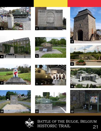
Start Point – Sherman TankThis Sherman tank is a popular monument in the Belgian town. The tank belonged to
the 11th Armored Division and was brought to a stop in the village of Renuamont on
Dec. 30, 1944, after a German attack. Its crew was captured by the Germans and
taken to a prisoner camp. Next to the tank is a monument to U.S. Army Brig. Gen.
Anthony C. McAuliffe for whom the square is named. Outgunned and outnumbered,
McAuliffe received a letter from German commanders on Dec. 22, 1944, requesting
the surrender of all American troops under his command. McAuliffe responded with the
now legendary retort: 'Nuts!'
50°00'02.7"N, 5°42’55.0"E – Place Général McAuliffe 33, 6600 Bastogne
Head south along the N30 about 400m to the Patton Memorial Park on your right.
Checkpoint #2 – Patton Memorial ParkThe monument in honor of General Patton was inaugurated September 8th 1963 in
the presence of his grandson Lieutenant John Waters. General Patton led the Third US
Army across France through the summer and fall of 1944. On Dec 16, he was ordered
to turn his Third US Army north to help relieve the American troops in the Battle of the
Bulge.
49°59'53.0"N, 5°42’58.5"E – Rue Merceny 11, 6600 Bastogne
Head back north along the N30 to the Place Général McAuliffe and continue northeast
on the N30 for about 600m. Turn right on the Rue de la Porte Haute to our next stop,
the Porte de Trèves.
Checkpoint #3 – Porte de TrèvesPorte de Treves is a saddening reminder of the war, being the only tower left from
what used to be majestic ramparts. In English, Porte de Treves means the Treves
gates. The tower is square and large, made entirely of sandstone.
7

BATTLE OF THE BULGE, BELGIUM
HISTORIC TRAIL8
Bastogne Hiking Route
Checkpoint #3 – Porte de Trèves (cont.)This means that the late-medieval ramparts of Bastogne were built using sandstone,
enhancing the strength and beauty of a crucial building. The building itself, however,
was burnt to the ground by the French in 1668. The tower, located near a famous
church, is the only remnant of the ramparts.
50°00'17.7"N, 5°43’19.3"E – Place St-Pierre, 6600 Bastogne
From the tower, head north to the N30 and across the street is our next stop, the
Bastogne War Monument.
Checkpoint #4 – Bastogne War MonumentThis memorial commemorates the residents of Bastogne who gave their lives in World
War I and World War II.
50°00'19.9"N, 5°43’18.8"E – Rue Gustave-Delperdange 1945, 6600 Bastogne
Head northeast along the Rue Gustave-Delperdange (N874) for about 650m to our
next stop.
Checkpoint #5 – Sherman Tank TurretOn all the major roads into Bastogne, Sherman turrets of different types mark the
places where the German advance to capture the surrounded city was stopped. This
turret is marked with the insignia of the 10th Armored Division, the unit that broke
through the encirclement of Bastogne to link up with the 101st Airborne Division.
50°00'30.9"N, 5°43’45.3"E – Rue Gustave-Delperdange 62, 6600 Bastogne
Continue along Rue Gustave-Delperdange for 150m to our next stop, a Belgian
Bunker.

BATTLE OF THE BULGE, BELGIUM
HISTORIC TRAIL
Bastogne Hiking Route
Checkpoint #6 – Belgian Bunker MonumentThis monument commemorates Corporal Emile Cady, the first Belgian killed during
the defense of Bastogne. The monument recalls the withdrawal of Belgian troops on 10
May 1940, the first day of the declaration of war from Germany to Belgium.
50°00'32.1"N, 5°43’53.2"E – Corner of Rue Gustave-Delperdange and Rue de
Clervaux, 6600 Bastogne
Continue along the Rue de Clervaux for about 400m to the Trail of Liberty Marker.
Checkpoint #7 – Liberty Road Marker #1147Liberty Road (French La voie de la Liberté) is the commemorative way marking the
route of the Allied forces from D-Day in June 1944. It starts in Sainte-Mère-Église, in
the Manche département in Normandy, France, travels across Northern France to
Metz and then northwards to end in Bastogne, on the border of Luxembourg and
Belgium. At each of the 1,146 kilometers along the route, there is a stone marker or
'Borne'. The first lies outside the town hall in Sainte-Mère-Église while this marker in
Bastogne is the final one on the road.
50°00'38.8"N, 5°44’11.8"E – Route de Bizory 6600, 6600 Bastogne
Follow Rue de Clervaux for about 250m to the Bastogne War Museum on your left.
Checkpoint #8 – Bastogne War MuseumThe old Bastogne Historical Center closed in 2011 and was transformed into the
Bastogne War Museum which opened in 2014. The updated museum covers the
Second World War, from its origins up to the autumn of 1944, and then focuses on the
Battle of the Bulge. Key events of the war and the combatants' ordeal are reproduced
here with the aim of clarifying the broad sweep of its history. The museum provides a
very clear picture of how the civilians lived during the occupation, during the battle
itself, and afterwards. The many consequences of what was probably one of the most
serious battles in world history are very clearly described.
9

BATTLE OF THE BULGE, BELGIUM
HISTORIC TRAIL10
Bastogne Hiking Route
Checkpoint #8 – Bastogne War Museum (cont.)Hours:
15 March to 15 November - 0930-1800
July and August - 0930-1900
16 November to 14 March - Tue-Sun 0930-1800, closed Monday except Holidays
Closed - 8 January to 8 February, 1 January & 25 December
Costs (as of February 2018)
Adult – 14€ Senior (65+) – 12€ Children (6-18) – 8€ Children under 6 – Free
Family – 2 adult + 2 children 36€ +7€ per extra child
School Groups – 7€ per student, 1 free adult per 15 children, extra teacher 7€
Youth Groups (6-18) – 7€ (groups of 20 or more)
Groups – 10€ per person (groups of 20 or more)
For groups, please book ahead of time. Call +32 (0)61 210 220 or email
[email protected] to set up a group visit. You are encouraged to visit the
museum website to check on updated prices and hours before you arrive at
http://www.bastognewarmuseum.be/home.html.
50°00'37.9"N, 5°44’21.5"E – Colline du Mardasson 5, 6600 Bastogne
Head south from the Museum about 100m to the star shaped Mardasson Monument.
Checkpoint #9 – Mardasson MonumentThe Mardasson memorial, which opened in 1950 on the outskirts of the town, is a big
star-shaped structure with five points. The story of the battle is engraved on the
monument’s walls, and it lists the units that took part in the fight, also known as the
Ardennes Offensive. There are excellent observation points on the roof, with bronze
maps showing details of the battlefield visible from each point of the star. A steep,
spiral staircase leads you to the top, where you can take in the hilly view and
contemplate all the fighting that took place during the siege of Bastogne.

BATTLE OF THE BULGE, BELGIUM
HISTORIC TRAIL
Bastogne Hiking Route
Checkpoint #9 – Mardasson Monument (cont.)
50°00'33.6"N, 5°44’20.6"E – Route de Bizory 1, 6600 Bastogne
Congratulations, you have completed the Battle of the Bulge Historic Trail! For those
intrepid hikers who like to see more, you can continue on the Battle of the Bulge
Perimeter Hike described over the next few pages. To continue the hike, return to the
Liberty Road marker at checkpoint #7 and turn right. Follow the road for about 2.5 km
to the town of Bizory.
Optional Checkpoint #10 – BizoryBizory was first defended by Company B, 158th Engineer Battalion starting the
morning of 18 December. Two platoons of B/158 took up defensive positions along the
Neffe-Bizory and Bizory-Foy roads between Neffe and the Bourcy railroad tracks (Halt
Station). A third platoon set up roadblocks forward of the company positions on the
N28 highway in Longvilly and Mageret. The company command post was in Bizory.
The company was augmented during the night by two platoons of Company C, 9th
Armored Engineers. At 2300 hrs 18 December German infantry overran the roadblock
in Mageret and the forward roadblock in Longvilly was cut off. After a night of hard
fighting, the 2nd Battalion, 502nd Infantry Regiment from the 101st Airborne Division
relieved the engineers just to the east of Bizory and defended a line just outside the
town until the unit attacked forward on 3 January 1945. You can still see marks of the
heavy fighting on the walls of buildings in the town.
50°01'10.5"N, 5°45’47.4"E – Bizory 6, 6600 Bastogne
After leaving Bizory, follow the road southeast for about 1.5 km to the town of Mageret.
If you wish to shorten this tour somewhat, you can leave out Magaret and go directly
from Bizory to Neffe. This road lies just to the west of the lines defended by the 101st
Airborne Division on the perimeter of the encirclement.
11

BATTLE OF THE BULGE, BELGIUM
HISTORIC TRAIL12
Bastogne Hiking Route
Optional Checkpoint #11 – MageretDuring the evening of 18 December, the Germans overran the roadblock in Mageret
and isolated several American units. Over the next two weeks, the town changed
hands several times as the fighting ebbed and flowed across the battlefield. The town
was finally recaptured by the 68th Tank Battalion during the afternoon of 1 January
1945. There is a Sherman tank turret near the intersection of the N874 and N821 to
mark the areas of fighting.
50°00'52.0"N, 5°47’05.9"E – Mageret 21, 6600 Bastogne, Belgium
From Mageret, you can follow the N874 south and west for about 2.5 km to the town of
Neffe.
Optional Checkpoint #12 – NeffeDuring the fighting on the 19th of December, the 9th Armored Division Roadblock at the
Neffe railroad station was overrun by the Germans. The town was retaken by the 69th
Tank Battalion during fighting on 31 December. At the town of Neffe there is a
historical display of photos from the battle next to the old church, which also shows
scars from the fighting.
50°00'20.6"N, 5°45’50.8"E – Rue de Clervaux 107, 6600 Bastogne, Belgium
You can now follow the N874 back to Bastogne and checkpoint #6, the Belgian Bunker
Monument. From there, you can continue back the start point or the Bastogne Scout
Hut.

BATTLE OF THE BULGE, BELGIUM
HISTORIC TRAIL
Other Nearby sites
Optional Checkpoint #13 – Recogne German Military
CemeteryIn February 1945, following the Battle of the Bulge, the US Army established a
cemetery in Recogne, where some 2,700 Americans and 3,000 Germans were
buried. After the war in 1945-1946, the remains of the fallen American soldiers were
transferred to Henri-Chapelle American Cemetery and Memorial. In the meantime, the
Belgian authorities started clearing all German cemeteries in the area, and transferred
all German graves either to Recogne or to Lommel German war cemetery. Therefore,
the cemetery also contains graves of Germans killed in 1940 or during the occupation.
In the 1950s the cemetery was transferred to the German War Graves Commission.
50°02'56.7"N, 5°44'28.5"E – Recogne 27, 6600 Bastogne, Belgium
From Bastogne, head north on the N40 for about 5km to the town of Foy. At Foy, turn
left toward Recogne and go about 750 meters. The cemetery will be on your left.
13
13

BATTLE OF THE BULGE, BELGIUM
HISTORIC TRAIL14
Other Nearby sites
Optional Checkpoint #14 – Easy Company FoxholesPerhaps the most recognized unit to fight is Bastogne is Easy Company, 506th Infantry
Regiment thanks to the book and miniseries “Band of Brothers.” During the Defense of
Bastogne, the men of Easy Company defended the line in the Bois Jacques on the
northeast side of Bastogne. Today there are several memorials near the woods and
you can still see remnants of the foxholes they dug in the frozen ground during the
battle.
Easy Company Monument
50°01'43.9"N, 5°45'23.3"E – Road between Bizory & Foy, 6600 Bastogne, Belgium
Easy Company Foxholes
50°02'09.6"N, 5°45'06.7"E – Road between Bizory & Foy, 6600 Bastogne, Belgium
From Bastogne, head northeast for about 4km to Bizory. At Bizory, turn left toward Foy
and go about 1km to the monument and 2km to the foxholes. The foxholes will be off
the road in the wood line on your left.
Monument Foxholes
14 14

BATTLE OF THE BULGE, BELGIUM
HISTORIC TRAIL
Other Nearby sites
Optional Checkpoints #15 & 16 – Luxemburg CemeteriesAbout 55km southeast of Bastogne, just on the outskirts of Luxemburg City, are two
military cemeteries. The Luxemburg American Cemetery contains the remains of
5,076 American service members. 22 sets of brothers rest side-by-side in adjacent
graves. Most of the interred died during the Battle of the Bulge which was fought
nearby in the winter of 1944/1945. Two flagpoles overlook the graves area. Situated
between the two flagpoles lies the grave of General George S. Patton.
Not far from the cemetery entrance stands the white stone chapel, set on a wide
circular platform surrounded by woods. It is embellished with sculpture in bronze and
stone, a stained-glass window with the insignia of the five major U.S. commands that
operated in the region, and a mosaic ceiling.
German fallen from the same battle are buried in the Sandweiler German war
cemetery, about 1.5 kilometers away. It contains the graves of 10,913 German
servicemen from the Battle of the Bulge in winter 1944 and spring 1945. The design of
the tombstones are dark stone crosses compared to white tombstones of the American
cemetery.
Luxemburg American Military Cemetery and Memorial
49°36'47.0"N, 6°11'13.5"E – 50 Val du Scheid, 2517 Luxembourg
https://www.abmc.gov/cemeteries-memorials/europe/luxembourg-american-cemetery
Sandweiler German War Cemetery
49°36'30.0"N, 6°12'11.4"E – CR234, 5239 Sandweiler, Luxembourg
http://www.volksbund.de/informationsmaterial/kriegsgrberstaetten/browse/12.html
15

BATTLE OF THE BULGE, BELGIUM
HISTORIC TRAIL16
Luxemburg
American Military
Cemetery
Sandweiler
German War
Cemetery
15
16

BATTLE OF THE BULGE, BELGIUM
HISTORIC TRAIL 17
Area Map
Bastogne
Area
Luxemburg
Cemeteries
Wiltz International
Scouting Center

BATTLE OF THE BULGE, BELGIUM
HISTORIC TRAIL18
Bastogne Hike Route Map

BATTLE OF THE BULGE, BELGIUM
HISTORIC TRAIL 19
N

BATTLE OF THE BULGE, BELGIUM
HISTORIC TRAIL20
Ba
st
og
ne
Pe
rim
et
er
Hik
e R
ou
te
Ma
p
BATTLE OF THE BULGE, BELGIUM
HISTORIC TRAIL 21
2
3
10
8
1
9
11
4 5
6
7
12

BATTLE OF THE BULGE, BELGIUM
HISTORIC TRAIL22
Camping – Bastogne Scout Hut
On the west side of the city there is a small Scout hut run by the local Belgian Scout
association. It is located just off the Rue des Maies, and there is a green and white
sign saying “SCOUTS-PATROS” to show the way (#17 on the Bastogne Hike map).
The hut has a large heated room with about 120 square meters of available floor space
where up to 40 people can sleep on the floor. The room has a large number of tables
and chairs; if you use these, please put them back in stacks the way you found them.
The Scout Hut also has bathrooms, running water (but the hot water is turned off in the
winter), and a large kitchen with two gas stoves (4 burners each) plus 3 large gas-fired
burners which can be used to heat large containers of water.
Cost: 125€ per weekend (Friday evening until Sunday afternoon)
The hut must be reserved in advance by contacting Mr. Benoit Fairon.
If you call him, it would be best to have a French speaker make the call, but he also
understands some English and Dutch.
50°00'20.8"N, 5°42'46.9"E - Rue des Maies 104, 6600 Bastogne
Address: M. Benoit Fairon, Avenue Olivier 8, B- 6600 Bastogne, Belgium.
Telephone: (32) 61 215090 (call in the evening) Fax: same number
Email: [email protected]
Mr. Fairon requests that units wishing to use the hut tell him their precise arrival time,
so that he can meet you at the hut to give you the keys and explain the workings of the
heating system, etc. Please don’t make him wait a long time for your arrival.
The Bastogne Scout Hut does not have its own campsite, but Mr. Fairon can arrange
for a unit to use a larger grassy area very close to the Scout Hut, where it also possible
to have a campfire. This area is owned by the Belgian Girl Scouts (the Guides), who
also have a hut nearby. If your unit wishes to camp there, you should still rent the
Bastogne Scout Hut so that you will have toilet facilities and running water available.
You can also use the Hut for shelter if the weather turns nasty, as can happen rather
quickly in the Ardennes.

BATTLE OF THE BULGE, BELGIUM
HISTORIC TRAIL
Camping – Wiltz International Scout Center
The Wiltz International Scouting Center is a much larger Scouting facility (the
largest in Europe), and is located 26 kilometers east of Bastogne (#18 on Area Map).
During the camping season, it hosts 80,000 Scouts a year from all over the world.
The Scout Centre is not a single building but eight chalets and seven campsites
surrounding the town. While less convenient because of the distance, Wiltz offers
chalets of different sizes with beds rather than just space on the floor (the number of
beds per chalet ranges from 15 to 45), as well as campsites that can hold up to 200
people. In the cabins, the cost ranges between 100-400€ per night. Campsites cost 5-
10€ per night per person. The cabins are open all year round, and the campsites (with
toilet facilities and water points) are normally open from late March until the end of
October, when the water is turned off to prevent pipes from freezing. There is also one
campsite that is suitable for year-round camping because its toilets and water are
located in a heated building. Check their website for the most up to date prices.
In the Scout Center in the Chateau de Wiltz, there is a small Scout shop run by the
Luxembourg Scout Association. Because Wiltz is an internationally known Scout
Center, you may have an opportunity to meet Scouts from other countries.
49°57'59.8"N, 5°56'14.6"E - Château de Wiltz, L-9516 Wiltz
Telephone: (+352) 95 81 99, Fax: (+352) 26 95 05 79
For more information, email [email protected] or visit their website at www.scoutswiltz.lu
23

BATTLE OF THE BULGE, BELGIUM
HISTORIC TRAIL24
Bastogne Historic Walk
Each year in early December, the Bastogne Historic Walk is held to commemorate the
Battle of the Bulge and pay tribute to the thousands of soldiers that gave the ultimate
sacrifice. It is typically held on the second or third Saturday of the month. Anywhere
from 2500 to 3000 people typically attend the event including many reenactors dressed
in period uniforms.
Walkers may choose 7-, 14- or 20-kilometer distances. The walk normally begins
between 7 to 9 am at the Sports Center of Bastogne on Rue Gustave Delperdange. It
is just outside the town, and it has ample parking for those arriving early.
There is a mandatory charge for walker’s insurance (2017 - 6€). The fee includes a
certificate from the city of Bastogne, a small souvenir map, a booklet and hot
beverages along the route. Pre-registration and payment is strongly recommended,
and refunds cannot be given
The walk finishes in time for three wreath-laying ceremonies in the center of Bastogne.
The public is also invited to participate in a memorial parade, scheduled in the
afternoon.
The traditional nut-throwing from the town hall balcony is immediately afterward, a
ceremony inspired by Gen. Anthony McAuliffe’s reply of “Nuts” to demands that his
men, surrounded by German forces, surrender.
Visit www.bastogne.be or www.usagbenelux.eur.army.mil for the latest information on
the next Historic Walk.

BATTLE OF THE BULGE, BELGIUM
HISTORIC TRAIL
Background Readings
Scouts should read this before going on the trail, and they can use it to answer the first
10 questions on the questionnaire.
Lead up to the Battle
By the autumn of 1944 World War II in Europe had already been going on for 5 years.
The expansion of Nazi Germany had been stopped at the end of 1942, and the Allies
had been on the offensive since then, pushing the Germans back on all fronts. The
Allied effort to liberate Western Europe began with the “D-Day” landings at Normandy,
France, on 6 June 1944 (and to learn more about this, your troop should go on the
“Omaha Beach - Normandy” Historical Trail). After overcoming German resistance on
the beaches, the Allies succeeded in building up strong forces in the Normandy
peninsula and with the help of massed Allied bomber attacks on the Germans, the
Allies broke out of Normandy and raced across France toward Germany. The defeated
German forces did not try to resist in France any longer but headed back toward the
“West Wall”(also known as the “Siegfried Line”), a line of fortifications along Germany’s
western border. Here the Germans finally had time to organize an effective defensive
line because they forced the advancing Allied troops to stop and wait until their
supplies (especially fuel for the vehicles) caught up with them.
To clear up the Allied supply problems once and for all and also to get across the
Rhine River and into Germany by going around the fortified “West Wall”, the Allies tried
a bold airborne and ground attack to seize a number of key river crossings. This
attack, known as Operation MARKET GARDEN, included parachute attacks by US and
British airborne units deep into German-held territory. The paratroopers captured and
held two major river crossings for use by the advancing armored units, but the
Germans were too strong at the last key bridge in the Dutch town of Arnhem (which
became famous in the book and movie known as A Bridge Too Far) and the Allies
failed to achieve the hoped-for breakthrough in September 1944.
25

BATTLE OF THE BULGE, BELGIUM
HISTORIC TRAIL26
Background Readings
Afterward heavy fighting continued in a number of areas as the Allies slowly ground
their way forward against strong German resistance. In November, the British finally
gained control of the rivers leading to the important port of Antwerp in Belgium, so that
Allied ships bringing in supplies could use it. The US First Army even fought its way
through a small portion of the “West Wall” and captured the German city of Aachen,
while farther south the US Third Army under the command of the famous Lieutenant
General (3-stars) George S. Patton beat back a German counterattack near the city of
Metz and slowly advanced through strong German resistance toward the West Wall.
By the middle of December 1944, Allies armies had advanced up to the Germans’
main defenses all along the line.
The Calm Before the Storm
There was one area where little fighting was going on, the large Ardennes Forest in
southeastern Belgium and Luxembourg. The heavy forests and hilly terrain of this area
made it difficult for the Allies to move large forces here, so this portion of the Allied line
did not have many troops defending it, and many of the US units there had been worn
out fighting on other portions of the line and had been sent to this “quiet sector” to get
a rest and build up their strength again. Most Allied leaders thought that the war was
almost over, and they certainly did not expect the Germans to make a major attack at
this time, especially because Germany was threatened by not only the US and British
armies attacking from the west but also the large Soviet (Russian) armies coming in
from the east.
But Nazi Germany’s leader (and that was his official title - Der Fuehrer which means
“The Leader”), the feared dictator Adolf Hitler, still thought that he could win the war
with new secret weapons that the Germans were beginning to produce - weapons like
rocket-propelled long-range missiles and jet fighters/bombers - if German troops could
win one last major victory in the West and gain the time he needed. Hitler decided that
this big German offensive should come in the Ardennes Forest, where the Allies would
not expect the Germans to attack.

BATTLE OF THE BULGE, BELGIUM
HISTORIC TRAIL
Background Readings
This was also the area where the Germans had broken through the Allied lines in
1940, leading to the defeat of France. Hitler’s goal was for German troops to break
through the Allied lines in the Ardennes Forest, capture badly- needed supplies, and
then advance to the port of Antwerp, cutting the Allied armies in two. All of the Allied
Forces to the northeast of Antwerp would be cut off from their supplies and could then
be destroyed. Such a tremendous victory - combined with the new secret weapons -
would make the Western Allies willing to make peace with Germany, Hitler thought,
and then the Germans could switch forces to the East and defeat the Russians.
Actually, Germany no longer was strong enough to carry out such an ambitious plan,
but no one dared say this to the Fuehrer!
For the German plan to succeed, they had to catch the Allies by surprise, and this
would not be easy because the Allies had a big advantage. They had built special
machines which were actually very early computers, enabling Allied codebreakers to
read most of the Germans’ secret coded radio messages. As a result, the Allies usually
knew in advance what the Germans were going to do, but to protect this very important
secret so that the Germans did not find this out and change their codes, the
information gained from reading the German secret messages was classified as TOP
SECRET ULTRA, which was much higher than TOP SECRET, and very few Allied
officers and leaders knew about it. Because of the ULTRA Secret, the Allies didn’t think
that the Germans could make any surprise attacks, but when Hitler ordered planning
and preparations for his Ardennes Offensive to begin, he also ordered radio silence (he
didn’t know that the Allies could read the German messages, but he thought they might
become suspicious if they saw a lot more message traffic taking place next to the
Ardennes Forest). As a result, there were no radio messages about the attack, which
meant that the ULTRA Secret could not give advance warning, and the Germans
caught the Allies by surprise when the attack began in the early morning hours of 16
December 1944.
27

BATTLE OF THE BULGE, BELGIUM
HISTORIC TRAIL28
Background Readings
The Attack Begins
In the north, the German Sixth S.S. Panzer Army (“Panzer” means tank, and the S.S.
were the infamous Nazi “Schutzstaffel” troops who were much more fanatical than
regular German soldiers and who also committed a number of war crimes) ran into stiff
American resistance and did not advance anywhere near as far as it was supposed to,
while the southernmost German army, the Seventh Army, made slow progress
because it did not have very many tanks. Only the central German Force, the Fifth
Panzer Army, succeeded in making a major breakthrough in the Allied line, and it
began racing westward. Bad weather aided the German advance, which kept Allied
airplanes from being able to launch attacks. The result of the German breakthrough in
the center was a huge bulge in the Allied lines, which soon led to the battle being given
the unofficial name of the “Battle of the Bulge”.
To assist their advancing units, the Germans had also created a special force of troops
wearing US uniforms and driving captured US vehicles or German vehicles modified to
look like US ones. Many of these soldiers spoke English, and their job was to dash
forward through the holes created in the Allied line and capture key road junctions and
bridges while also cutting telephone and telegraph lines and possibly even attacking
US units from behind. A few were even dropped by parachute. Very few of these fake
US troops actually succeed in getting behind the Allied lines, but word of their
existence quickly spread, and US soldiers started questioning any strangers in US
uniforms to see if these men were real Americans or German spies. The strangers
were asked detailed questions about American movie stars or baseball players, which
Germans would not be able to know, even if their English was good. The result was
lots of confusion behind the lines, and anyone who was not interested in sports or
movie stars had a lot of explaining to do, but the Germans did not succeed in carrying
out their original mission and some of these Germans in US uniforms were captured
and then executed for being spies.

BATTLE OF THE BULGE, BELGIUM
HISTORIC TRAIL
Background Readings
Defense of Bastogne
As soon as the German attack began, the Supreme Commander of the Allied armies in
Western Europe, General of the Army (5 stars) Dwight D. Eisenhower (later President
of the United States from 1952-1960) started rushing reinforcements to the threatened
area. Eisenhower sent one of the reinforcing divisions, the 101st Airborne Division, to
the Belgian town of Bastogne and told them to hold this key road junction at all costs
so that the Germans would not be able to bring their supplies forward.
When the battle started, the division commander, Major General Maxwell D. Taylor,
was back in Washington trying to get his division moved from this “quiet area” to the
Pacific to fight the Japanese and the assistant division commander was at a
conference discussing the lessons learned from the recent parachute landings in
Operation MARKET GARDEN.
Because of their absences, Brigadier General Anthony C. McAuliffe, who normally
commanded the division’s artillery, was temporarily in overall command. Arriving in
Bastogne just ahead of the Germans on 19 December, the paratroopers (along with
smaller armored units from several other divisions) began setting up a strong defense
that soon became a circle around the town as the Germans started going around
Bastogne after they were not able to break through from the east.
By 21 December (see map on pages 32-33) , the Germans had surrounded Bastogne,
and on the following morning, the Germans sent a messenger to General McAuliffe
saying that his division was surrounded and the situation was hopeless, so he should
surrender. General McAuliffe’s reply was “Nuts!” which meant that he thought that the
Germans were crazy to think that the 101st Airborne Division would surrender just
because it was surrounded.
29
BATTLE OF THE BULGE, BELGIUM
HISTORIC TRAIL30
Background Readings
While the siege of Bastogne began, German Panzer divisions continued to advance
westward and even came very close to their initial objective of the Meuse River by
December 24th, but their supplies were not getting through (thanks in part to the 101st
Airborne Division’s stubborn defense of the important road junction at Bastogne) and
their tanks began running out of fuel.
In addition, the bad weather that had been keeping Allied aircraft on the ground finally
ended on December 23rd, and Allied air attacks soon began causing heavy losses to
German troops and vehicles.
During the days immediately before, during, and after Christmas, the defenders of
Bastogne had to beat back a number of German attacks on the besieged city. But help
was on the way. General George S. Patton had stopped his Third Army’s attack on the
Germans far to the south, turned his force in a completely new direction faster than
anyone had thought possible, and was now heading with all possible speed toward
Bastogne.
On 26 December (see map on page 34), tanks of the 4th Armored Division broke
through the German circle and reached Bastogne, but the fighting in the area was not
yet over. Hitler insisted that Bastogne must be captured, and the town now became the
Germans’ main objective. The Germans tried attacks at various points around the town
in the days that followed but were always stopped by the defenders, who were
constantly being reinforced by General Patton’s troops.
The last German attack against Bastogne took place on 4 January 1945, and that
same day the German High Command ended the attempts to capture the city and
ordered a retreat. At the same time, the Germans were being pushed out of the rest of
the Bulge. On 16 January 1945 Allied troops attacking from the north edge of the
Bulge linked up with those coming from the south edge, and the battle was over, with
the Bulge in the Allied lines just about completely gone.

BATTLE OF THE BULGE, BELGIUM
HISTORIC TRAIL
Background Readings
Aftermath
The 11,000 officers and men of the 101st Airborne Division who defended Bastogne
during the battle suffered 3,400 casualties; losses among the Germans trying to take
the town were much higher. The successful defense of Bastogne was one of the main
reasons why the Germans failed to break out of the “Bulge” and accomplish their
original goals.
As for the battle as a whole, a total of around 650,000 Allied troops were eventually
involved in the battle, and their losses were approximately 82,000 men killed,
wounded, missing, or captured. The Germans, who used around 500,000 men in the
battle, lost at least 120,000 men. Both sides lost large numbers of tanks and assault
guns; the Allies could easily replace these losses with new equipment, but the
Germans - whose factories were under constant Allied aerial bombardment - could not.
Hitler’s attempt to win the war had failed, and the heavy German losses actually
hastened the end of the war in Europe, since fewer troops and tanks were left to
defend Germany.
31
9th Armored Division 101st Airborne Division 10th Armored Division
US Army Divisions in the Defense of Bastogne

BATTLE OF THE BULGE, BELGIUM
HISTORIC TRAIL32

BATTLE OF THE BULGE, BELGIUM
HISTORIC TRAIL 33

BATTLE OF THE BULGE, BELGIUM
HISTORIC TRAIL34

BATTLE OF THE BULGE, BELGIUM
HISTORIC TRAIL
Historic Trail Quiz
Background (from the reading on the battle)1. During World War Two the most powerful man in Germany was Adolf Hitler, and it was his idea to
attack the Allies in December 1944 even though the war seemed lost for Germany. What was Hitler’s
official title? ANSWER: ________________________
2. Who was the Supreme Commander of the Allied armies fighting against the Germans in Western
Europe? How many stars did he have? ANSWERS: Name _____________________ Stars ____
3. By late 1944 the Allies thought the Germans would never be able to make a surprise attack
because Allied codebreakers had figured out how to read most of the Germans’ secret messages
and thus usually knew in advance what the German were planning to do. Naturally the Allies did not
want the Germans to know that their secret messages were being read, so this very important
codebreaking ability of the Allies was given a security classification which was much higher than TOP
SECRET. What was this classification? ANSWER: TOP SECRET ________
4. Which famous Belgian port was the place the Germans hoped to reach in order to split apart the
Allied armies? ANSWER: ________________________
5. On what date did the German attack begin? ANSWER: ________________________
6. At the start of the battle the Germans sent in special troops dressed as US soldiers and speaking
English. Their job was to capture key bridges and road junctions for use by the main German
attacking forces. When American soldiers ran into strangers in US uniforms, how did they try to find
out which ones were real Americans and which ones were German spies?
ANSWER: ________________________
7. Who commanded the 101st Airborne Division troops when Bastogne was surrounded?
ANSWER: ________________________
8. What was his normal job? ANSWER: ________________________
9. What was this general’s famous reply to the Germans’ demand that the US troops surrounded in
Bastogne surrender? ANSWER: ________________________
10. When did the Allied troops attacking from the north side of the “Bulge” meet up with the Allied
troops coming from the south side, thereby getting rid of almost all of this Bulge in the Allied lines?
ANSWER: ________________________
35

BATTLE OF THE BULGE, BELGIUM
HISTORIC TRAIL36
Historic Trail Quiz
On the trail, starting at the tank on the corner of McAuliffe Square11. What kind of tank is parked at the corner of McAuliffe Square?
ANSWER: ________________________
12. What is its serial number?
ANSWER: ________________________
13. Take a close look at this tank, which was damaged during the Battle of the Bulge. Two hits are
visible, but only one of these caused enough damage to knock out the tank. Where is this hit?
ANSWER: ________________________
14. When was the central square of Bastogne given the name “McAuliffe Square”? (Hint: look around
the area near the tank.)
ANSWER: ________________________
15. One of the reasons why the Germans wanted to capture Bastogne so much was that the city was
a major road junction. At the road intersection by the tank on McAuliffe Square there are road signs
showing that 5 major Belgian National Roads (“Routes Nationales,” which have “N” numbers). What
are these five National Roads?
ANSWER: Routes N-_____, N-_____, N-_____, N-_____, and N-_____
16. How many stars are shown on General Patton’s helmet at the memorial to him? How many did he
actually have during the battle? (Check your reading.)
ANSWER: ____________, ____________
17. Until recently the US flag flying at the front of the Patton memorial was the version used in World
War II, but now it is the normal 50-star flag. How many stars were on the US flags of World War II?
ANSWER: ________________________
Extra Credit: Which two states have been added to the flag since World War II?
ANSWER: ________________________ and ________________________
18. The Patton Memorial also contains a stone memorial to a Belgian unit that was commended for
meritorious and outstanding performance of duty while serving with General Patton’s Third Army.
What was the name of this Belgian unit?
ANSWER: ________________________

BATTLE OF THE BULGE, BELGIUM
HISTORIC TRAIL
Historic Trail Quiz
19. Right before you leave Bastogne on the road to the Mardasson Memorial and the Bastogne War
Museum, you pass a large stone gate on the right that is the last remaining part of Bastogne’s old city
walls. What is the name of this structure? (Hint: there is no sign on this old stone gate, so you may
have to look at the closest street sign to find the answer.)
ANSWER: ________________________
20. How many steps lead up to the wooden entrance of this gate on the south side?
ANSWER: ________________________
21. When you return to the main road from the old stone gate and continue a very short distance to
the intersection where a road leads out of town to the Bastogne War Museum, you will see a large
memorial to the citizens of Bastogne who died in World Wars I and II. How many inhabitants of
Bastogne were killed during World War II while fighting against the Germans as resistance fighters
(“Resistants”)?
ANSWER: ________________________
22. On the way to the Mardasson Memorial you will pass a US tank destroyer turret on a monument.
What division was this tank from?
ANSWER: ________________________
23. If you look carefully at the turret you will see where it was hit by an enemy shell or rocket. Where
is this hit located?
ANSWER: ________________________
24. Right before you turn left from the road out of Bastogne to walk up to the Mardasson Memorial,
you will see a concrete bunker used by the Belgian Army to defend the area against the German
invasion of 1940. On what day did Corporal Emile Cady of the 2nd Regiment of Ardennes Riflemen
(Chasseurs d’Ardennes) die next to this bunker?
ANSWER: ________________________
25. While going uphill you will make one more turn to the right just before you reach the Bastogne
War Museum and Mardasson Memorial. At this intersection there is a stone marker (milestone) that
is part of a long trail of such markers that begin at Normandy and stretch across France and Belgium,
ending at the Mardasson Memorial. What is the name of this trail marked by these milestones? (You
can answer in English or French.)
ANSWER: ________________________
37

BATTLE OF THE BULGE, BELGIUM
HISTORIC TRAIL38
Historic Trail Quiz
At the Bastogne War Museum
(Museum next to the Mardasson Memorial)
26. What are the names of the 4 narrators in the museum?
ANSWER: ________________, ________________, ________________, & ________________
27. What units are the two Soldier narrators from?
ANSWER: ________________________, ________________________
28. There are two Sherman Tanks exhibited in the Museum. What are their names?
ANSWER: ________________________, ________________________
29. During your immersion in the basement of a pub in Bastogne, what day is the bombing raid?
ANSWER: ________________________
30. The museum has a kind of German jeep known as the KFZ 1 Kubelwagen, which was made by a
very famous German automobile manufacturer that is still making cars today. What is the name of
this company?
ANSWER: ________________________
31. Near the German jeep, the flags of the 10th Armored Division and 101st Airborne Division are on
display. What two main colors are used on each flag?
ANSWER: ________________________
32. What is the bumper number on the US Army jeep displayed in the museum?
ANSWER: Left -____________, Right -____________

BATTLE OF THE BULGE, BELGIUM
HISTORIC TRAIL
Historic Trail Quiz
At the Mardasson Memorial
33. How many flags fly outside the Mardasson Memorial?
ANSWER: ________________________
34. What shape are all of the US armored division patches?
ANSWER: ________________________
35. Wood Badge is the highest level of training for adult Scout leaders, and its symbol is an axe
sticking in a log. Which US infantry division at the Battle of the Bulge used the same symbol on its
division patch?
ANSWER: ________________________
36. What is the symbol of the 101st Airborne Division?
ANSWER: ________________________
Extra Credit: What is this division’s nickname?
ANSWER: ________________________
37. Panel 9 shows how the Belgians of Bastogne helped the US soldiers camouflage themselves and
their equipment to blend in with the snow. What did the Belgians do:
ANSWER: ________________________
38. According to the panel 10 at the Mardasson Memorial, how many US soldiers were killed,
wounded or listed as missing during the Battle of the Bulge?
ANSWER: ________________________
39. In the Crypt underneath the Mardasson memorial there are three altars. What three religions do
these represent?
ANSWER: ________________, ________________, and ________________
Answers on page 43
39

BATTLE OF THE BULGE, BELGIUM
HISTORIC TRAIL40
BSA Requirements
Completion of the Battle of the Bulge Historic Trail may
complete the following Requirements:
Cub Scouts:Tiger:
My Tiger Jungle Req 1
Tigers in the Wild Req 1, 2, 4
Tiger Tales Req 7
Wolf:
Paws on the Path Req 1-5
Finding Your Way Req 4
Bear:
Fur, Feathers, and Ferns Req 1
Paws for Action Req 2B
Webelos:
Webelos Walkabout Req 1-6
Boy Scouts:Tenderfoot: Req 4d, 5a, 5b, 5c
Second Class: Req 3a, 3b, 3c, 3d, 6c
First Class: Req 4a, 4b
*Note: Requirements for the Citizenship in the Community, Citizenship in the Nation,
Hiking, Orienteering, and American Heritage Merit Badges and the Cub Scout Outdoor
Activity Award can be earned by completing this hike and learning about sites found on
this hike.

BATTLE OF THE BULGE, BELGIUM
HISTORIC TRAIL
Notes
_____________________________________________
_____________________________________________
_____________________________________________
_____________________________________________
_____________________________________________
_____________________________________________
_____________________________________________
_____________________________________________
_____________________________________________
_____________________________________________
_____________________________________________
_____________________________________________
_____________________________________________
_____________________________________________
41

BATTLE OF THE BULGE, BELGIUM
HISTORIC TRAIL42
Notes
_____________________________________________
_____________________________________________
_____________________________________________
_____________________________________________
_____________________________________________
_____________________________________________
_____________________________________________
_____________________________________________
_____________________________________________
_____________________________________________
_____________________________________________
_____________________________________________
_____________________________________________
_____________________________________________

BATTLE OF THE BULGE, BELGIUM
HISTORIC TRAIL
Notes
_____________________________________________
_____________________________________________
_____________________________________________
_____________________________________________
_____________________________________________
_____________________________________________
_____________________________________________
_____________________________________________
Quiz Answers: 1) The Leader (Der Fuehrer);2) General Dwight D. Eisenhower, 5 stars; 3) ULTRA;
4) Antwerp; 5) 16 December 1944; 6) Asked questions that only Americans could know - sports,
movie stars, etc.; 7) Brigadier General Anthony C. McAuliffe; 8) Division Artillery Commander;
9) Nuts!; 10) 16 January 1945; 11) Sherman (M-4); 12) 3081532; 13) Left side (the hit on the rear of
the tank did not penetrate into the hull); 14) 15 July 1950; 15) Routes N-4, N-30, N-85, N-834, N-874;
16) 4,3; 17) 48 EXTRA CREDIT: Hawaii, Alaska; 18) 11th Belgian Fusiliers; 19) Porte de Treves;
20) 15; 21) 6; 22) 10th Armored Division; 23) Left side of turret; 24) 10 May 1940; 25) Voie de la
Liberte (Trail of Liberty); 26) Emile Mostade, Mathilde Devillers, Lieutenant Hans Wegmüller,
Corporal Robert Keane; 27) Corporal Keane - 101st Airborne Division, Lieutenant Wegmüller - 26th
Volksgrenardier Division; 28) ABSENTEE and BLOCKBUSTER; 29) 22 December 1944; 30) VW or
Volkswagen; 31) 10th Armored Division - Red and Green, 101st Airborne Division - Red and Blue;
32) Left - 101-AB-327-I, Right - HQ-5♧; 33) 4; 34) Triangle; 35) 84th Infantry Division; 36) Eagle
EXTRA CREDIT: Screaming Eagles; 37) Tore up bedsheets to make white camouflage; 38) 76,890;
39) Protestant, Catholic, and Jewish
43

BATTLE OF THE BULGE, BELGIUM
HISTORIC TRAIL
This Historical Trail was first approved in 1980 and designed by
Scouters of Troops 1 and 26 in Heidelberg, Germany. Mr Greg
Pedlow, of the SHAPE Historians Office, updated the trail as part of
his Wood Badge ticket in 1998 and he again updated it in 2002.
Additional Historic Trails in the Transatlantic Council area can be found at http://tac-
bsa.org/program/historic-trails/ or by scanning the QR Code below.
Updated 2 March 2018