Building the NORTH JETTY on ISLAND BEACH...
16
Building the NORTH JETTY on ISLAND BEACH Barnegat Inlet 1937 – 1940
-
Upload
vuongkhuong -
Category
Documents
-
view
223 -
download
3
Transcript of Building the NORTH JETTY on ISLAND BEACH...

Building theNORTH JETTY
on ISLAND BEACH
Barnegat Inlet
1937 – 1940

Map of Barnegat Inlet 1866

Building the NORTH JETTY
on ISLAND BEACH
Barnegat Inlet1937 – 1940
Ferdinand F. KleboldResearched & Written
Dedicated toPauline Miller
Ocean County Historian
Photos by Lewis D. Crowell, Island Heights, NJ
Janice Wheeler, CollectionOcean County Historical Society
Cover Photos - Kenneth Hollins, Seaside Park

I wish to thank the following for all the help, advice and encouragement in writing this article:
Michael J. Brodhead, Ph. D., U.S. Army Corp of Engineers Elizabeth B. Dudas Janis Gibson Kenneth Hollins Richard Kuntz Clara La Parch Richard Updike Ocean County Library Main Branch
Map of Barnegat Inlet 1917.Note how far channel has moved in 51 years.

BUILDING THE NORTH JETTY ON BARNEGAT INLET
In the early 1600’s, Barnegat Inlet was discovered and named “Baren-gat” by Dutch explorers. It was one of the most dangerous inlets to navigate along the Atlantic Ocean coast of New Jersey. The locally built wooden sailing schoo-ners, fifty to seventy feet long and smaller sloops using the inlet in the 1800’s were built with centerboards and keels so they could navigate the shallow waters of the inlet and Barnegat Bay. These vessels sailed from the ports of Toms River, Waretown, Barnegat and Forked River year round ex-cept when the bay was frozen. Cargos were mainly charcoal, wood splints and cord wood destined for New York City tenement housing. The fast-er-sailing sloops in summer and fall carried produce, huckleberries, cranberries, clams and other seafood. In 1852 eleven or more schoo-ners left the port of Toms River bound for New York in a week. They returned with merchandise and other supplies for the shops in the area.
In January 1937, after many years of trying, New Jersey Secretary of State, Thomas A. Mathis, a former sea captain, and the Ocean County Freeholders final-ly were able to have a bill introduced by State Senator Percy Camp to the State Legislative body to improve Barnegat Inlet. The bill authorized the spending of $270,000
1937 map of proposed improvements ro be made to
Barnegat Inlet

to dredge the inlet deeper and construct two stone jetties north and south of the inlet. This was the first effort to make this waterway safe for small craft since its discovery.
In February 1937 Captain A.A. Fleming, Secretary of Long Beach Island Fisherman’s Association stated “Some-times there was only three foot of water, shifting channels causing twenty-one deaths in ten years. The summer of 1936 the U.S. Coast Guard towed 67 disabled boats, rescued 16 drowning men; about 300 pleasure, party boats and com-mercial boats use the inlet a day.”
The Inlet bill was passed by both houses of the N.J. Legis-lature in April, 1937, and towards the end of May the Ocean County Freeholders appropriated an additional $252,000. Then there was a need for Federal money to start the project.
View of the cable tower, railroad trestle from the cove on the north side of the inlet runs to the edge of the ocean.
Looking south is the cable tower in Barnegat City and light house. To the right is the sand dredge in the inlet with the
outflow pipes running to the shore in Barnegat City.

The cable tower and railroad trestle on Island Beach with a south view of Barnegat City over
the inlet. Note the sand dredge.
Cross section of Railroad track design to build the jetty.
F. KLEBOLD
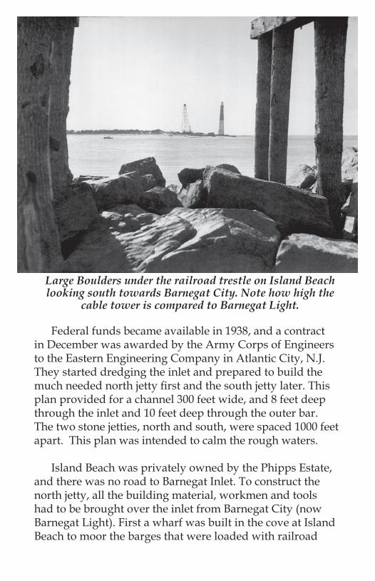
Federal funds became available in 1938, and a contract in December was awarded by the Army Corps of Engineers to the Eastern Engineering Company in Atlantic City, N.J. They started dredging the inlet and prepared to build the much needed north jetty first and the south jetty later. This plan provided for a channel 300 feet wide, and 8 feet deep through the inlet and 10 feet deep through the outer bar. The two stone jetties, north and south, were spaced 1000 feet apart. This plan was intended to calm the rough waters.
Island Beach was privately owned by the Phipps Estate, and there was no road to Barnegat Inlet. To construct the north jetty, all the building material, workmen and tools had to be brought over the inlet from Barnegat City (now Barnegat Light). First a wharf was built in the cove at Island Beach to moor the barges that were loaded with railroad
Large Boulders under the railroad trestle on Island Beach looking south towards Barnegat City. Note how high the
cable tower is compared to Barnegat Light.

Empty cable containers for stones and small rocks stacked on boulders at Barnegat City.
Ocean County Historical Society photo
Railroad flat car loaded with boulders to be placed on north jetty by self propelled steam derrick.
Note how low the tide is in the inlet.

track, railroad ties that had been creosoted, coal for the steam derrick, spikes, pilings and other equipment to build a railroad trestle. When this dock was long enough, a self propelled railroad steam derrick and pile-driver were ferried over, along with a railroad flat car. More supplies were ferried over, a cement mixer, outhouses, and a building to house the donkey engine that would power the cable way. Also the steel frame for the cable tower, cement and coarse sand for the foundations.
Before the jetty work could start, four foundations had to be poured to erect the 165-foot steel framed cable towers on both sides of the inlet. When the towers were finished,
A view from Barnegat City across the inlet to the cable tower, railroad trestle and north jetty that is under construction on Island Beach. To the left at
the bottom of the photo are the empty containers for shipping the stones and small rocks.
Ocean County Historical Society photo.

a heavy duty wire cable was strung across the inlet. It was powered by two donkey diesel engines. Fastened to the cable was an iron chain with a large, leather sling that would carry the stones, rocks and boulders over the water.
The railroad trestle was extended to the ocean to begin constructing the rock jetty 4900 feet into the ocean (380 ft. short of a mile). In October 1938, before the contract was is-sued, the Army Corps of Engineers proposed that the under water jetties would only be seen at low tide. This caused an uproar with the local, county and state governments. Underwater jetties would be a menace to navigation. There were hearings at the Court House in Toms River in March 1939. In May 1940 the District Army Engineer rejected the proposed jetty height increase.
L to R Island Beach cable tower, Barnegat Lighthouse and the cable tower in Barnegat City. Note building
at the foot of the tower that houses the donkey engine that powers the cable.
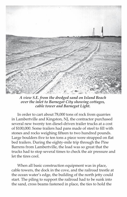
In order to cart about 78,000 tons of rock from quarries in Lambertville and Kingston, NJ, the contractor purchased several new twenty ton diesel-driven trailer trucks at a cost of $100,000. Some trailers had pans made of steel to fill with stones and rocks weighing fifteen to two hundred pounds. Large boulders five to ten tons a piece were strapped on flat bed trailers. During the eighty-mile trip through the Pine Barrens from Lambertville, the load was so great that the trucks had to stop several times to check the air pressure and let the tires cool.
When all basic construction equipment was in place, cable towers, the dock in the cove, and the railroad trestle at the ocean water’s edge, the building of the north jetty could start. The piling to support the railroad had to be sunk into the sand, cross beams fastened in place, the ties to hold the
A view S.E. from the dredged sand on Island Beach over the inlet to Barnegat City showing cottages,
cable tower and Barnegat Light.

rails bolted, and the rails spiked. When this was done, the small stones were sent over by cable and emptied on the railroad flat car. The small stones were placed on the seabed first. Then the medium rocks were sent over, and the jetty was topped off with the huge boulders. It would be built to a height that the boulders would be just covered by high tide. It was tedious and dangerous work in all kinds of weather, including northeast storms, rain, snow, heat of summer, etc. When the end of the jetty was reached, the contractors reversed the operation, removing everything but the jetty piling on the way back, including the wharf and railroad trestle. The cable towers were dismantled and the foundations destroyed.
The east end of the jetty was marked with beacons mounted on steel cylinders. They were felled by Tropical
Another view from the Sea-dog-island area on Island Beach S.E. to Barnegat City showing the cable tower and
light house and pumped sand fill from the inlet.

The remains of the railroad track trestle pilings after the north jetty had been completed.
storm Sandy in October 2012, and now have been replaced. The jetties were completed on September 24, 1940. The total amount expended for the construction of the Barnegat In-let jetties as of June 30, 1941 is $752,816.28, which included $300,000 contributed by county and state governments.
Ferdinand F. Klebold, August 30, 2013, Toms River, NJ
Printed by Central Printing Toms River, NJ

mounted on steel cylinders. They were felled by Tropical storm Sandy in October 2012, and now have been replaced. The jetties were completed on September 24, 1940. The total amount expended for the construction of the Barnegat In-let jetties as of June 30, 1941 is $752,816.28, which included $300,000 contributed by county and state governments.
Ferdinand F. Klebold, August 30, 2013, Toms River, N.J.
MAP OF BARNEGAT
INLET AREA2012

Brought to you by
Friends of Island Beach State Park
FOIBSP, INC.POB 406, Seaside Park, NJ 08752
www.friendsofislandbeach.org