Building Capacity for Land Cover Mapping in Africa World Bank Land and Poverty Conference March 26,...
12
Building Capacity for Land Cover Mapping in Africa World Bank Land and Poverty Conference March 26, 2015 Jean Parcher Project Manager U.S. Department of the Interior, International Technical Assistance Program
-
Upload
brandon-greene -
Category
Documents
-
view
215 -
download
1
Transcript of Building Capacity for Land Cover Mapping in Africa World Bank Land and Poverty Conference March 26,...

Building Capacity for Land Cover Mapping in Africa
World Bank Land and Poverty Conference
March 26, 2015
Jean ParcherProject ManagerU.S. Department of the Interior, International Technical Assistance Program [email protected]

Challenges in Africa
• Global and regional – do they meet national needs?
• Land use vs. land cover data• Lack of data sharing and spatial data
infrastructure• Multiple donors providing capacity - is it
coordinated?• Low priority for national government funding

Land Cover in Malawi (March 2014)
Assessment of Land Cover Mapping in MalawiExisting Data and Institutional Factors
Final Report
Tom Miewald (USFWS) and Phoebe Oduour (RCRMD)
Supported by USAID GCC and Dept. of Interior

Opportunities
• Free and open satellite data (Landsat series, Sentinels, and Google Earth Engine)
• Regional Center expertise:– RCMRD, Nairobi (SERVIR hub)– CSIR, South Africa– Agrhymet, Niger– RECTAS, Nigeria
• Group on Earth Observations– AfriGEOSS– Working Group on Land Cover for Africa
• UNFCCC GHG Inventory– National requirements for land use change statistics
• UNREDD Forest Inventory– USFS, USGS, FAO

Working Group on Land Cover for Africa
• Launched November 2013 at Addis Ababa, Ethiopia at GSDI and Africa GEOSS• Website http://www.earthobservations.org/afrigeoss_tmp.php
• Executive Board – Eastern Africa - Dr. Hussein Farah, Chair, RCMRD– Northern Africa – Dr. Kamal Labbassi, Chouaib Doukkali Univ.– Southern Africa – Bulelwa Semoli, National Geospatial Information– Indian Ocean – Solofo Rakotondraompiana, University of Antananarivo– Central Africa – Aboubakar Mambima Ndjougui, Gabon Space Agency– Western Africa – Keita Mahamadou, RECTAS
• Major Tasks in work:Inventory of Land Cover datasetsMethods for accuracy and validation of land cover data for Africa
• Launching of Technical Advisory Group – GEO 2014 Plenary – Co-chairs – Amadou Dieye – Senegal, Jean Parcher – U.S.– Bimonthly (every 2 months) conference call

Land Cover for Climate LC4Climate
US Department of the Interior (Science, Environment, Natural Resources) International Technical Assistance Program
Funding from USAID Global Climate Change program
Coordination with UNREDD (Silva Carbon), US EPA, and USGS Global Land Cover
Earth Observations Land Cover Capacity Building Build capacity to generate 30 meter resolution land cover data from Landsat
imagery Host regional and national capacity training on interpreting, and utilizing land
cover data for climate change reporting requirements (GHG, UNREDD+, LEDS).
Facilitate interagency cooperation to build consolidated data for multiple uses

Role for LC4Climate• Regional Coordination support
– GEO Working Group on Land Cover for Africa • Technical expertise
– Image preprocessing (USGS)– Remote sensing algorithms for land cover mapping (USGS, FWS)– Land use change data needs for GHG inventories (EPA, USGS, FWS, FAO)
• Data providers– Satellite imagery– Regional land cover
• Capacity training– East Africa– West Africa– Support for south to south collaboration –South Africa CSIR, RCMRD

Activities - Africa Regional Coordination
• International Global Land Cover Workshop for Africa• Co-hosted with RCMRD, UNEP, and Tsinghua Univ., June 25-27th,
2013 Nairobi, Kenya. – Released Final Statement – GEO WGLCA– Over 100 participants both from Africa, Europe, Asia, and US
• Eastern Africa participatory workshop to evaluate USGS 30 meter land cover dataset in cooperation with RCMRD (March 2014)
• Technical exchange with USGS EROS, South Africa CSIR , RCMRD, Univ. of Maryland, to improve image processing methodology and land cover change processes (July 2014)

Eastern and Southern 30M Land Cover
South Sudan, Uganda, Rwanda, Burundi, Tanzania, Malawi, Mozambique, Swaziland, Lesotho, and Kenya
(1) Closed Forest, (2) Open Forest, (3) Shrub lands, (4) Grasslands, (5) Croplands, (6) Barren, (7) Wetlands, and (8) Water Bodies
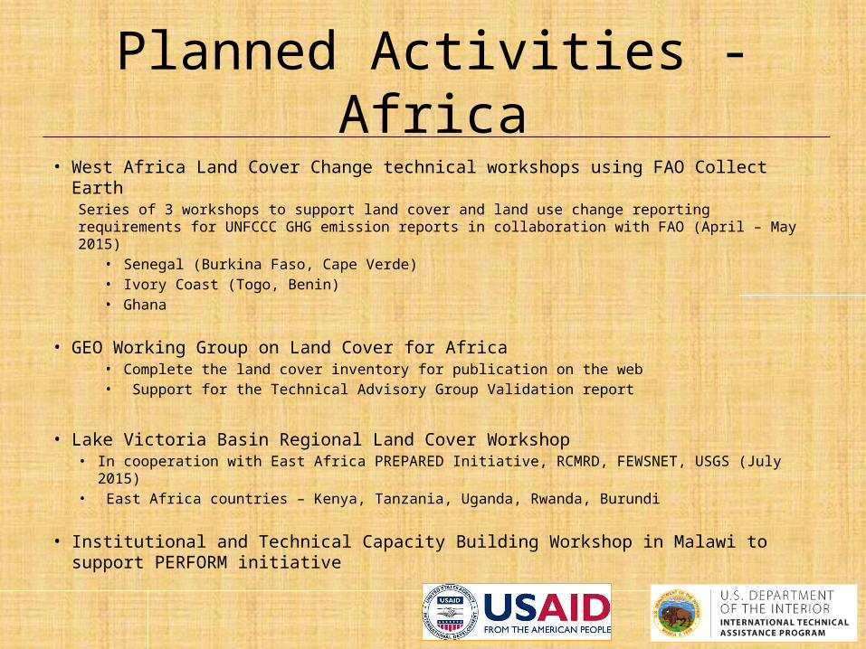
Planned Activities - Africa• West Africa Land Cover Change technical workshops using FAO Collect Earth
Series of 3 workshops to support land cover and land use change reporting requirements for UNFCCC GHG emission reports in collaboration with FAO (April – May 2015)
• Senegal (Burkina Faso, Cape Verde)• Ivory Coast (Togo, Benin)• Ghana
• GEO Working Group on Land Cover for Africa • Complete the land cover inventory for publication on the web• Support for the Technical Advisory Group Validation report
• Lake Victoria Basin Regional Land Cover Workshop• In cooperation with East Africa PREPARED Initiative, RCMRD, FEWSNET, USGS (July 2015)• East Africa countries – Kenya, Tanzania, Uganda, Rwanda, Burundi
• Institutional and Technical Capacity Building Workshop in Malawi to support PERFORM initiative

U.S. Department of the InteriorInternational Technical Assistance Program (ITAP)
FAO Collect Earth
• Customizable data collection with direct linkages to imagery in:• Google Earth Engine• Microsoft/Bing Maps Imagery• Nokia HERE maps
• Land Cover/Land Use collection• Sampling approach or wall to wall
supervised classification• Customizable interface• Multi-lingual• Output directly links to ALU tool
• Capacity training by FAO in 18 countries• Direct ownership of data and
project
Point-based LULUCF sampling using multiple sources of free imagery
Multi-temporal analysis with 40 years of Landsat data
Free and Open Source Tools for Image Processing and Data Analysis

Recommendations
• Project based capacity building• Capitalize on satellite imagery cloud based systems• Build on local knowledge of the environment and
drivers of change• Allow users to define their capacity needs • Increase cooperation between donors to build capacity • Provide resources to implement south to south technical
cooperation to build communities of practice • Strongly encourage open data policies for all doner
funded projects