Build DTM from Elements - Iowa Department of … 40 – Design Survey Specifications Section 40D-8...
9
Page 1 of 8 DTM Model 1.) Shown at the right is a zoomed- in picture of a DTM model. This model contains all survey elements classified as zone 2 or 3. This means that all of these elements are good for ground elevations. Because these items are drawn into a 3D MicroStation model, we can use these graphics to create a digital terrain model (DTM) or in GEOPAK terminology a triangulated model (TIN). Creating a TIN file in GEOPAK is a two-step process: creating a “.dat” file that contains all of the XYZ data from file, then converting this information into a TIN. Spot Shots 2.) All of the survey elements in this model belong to one of two groups. The first of these groups includes the spot shots. These are the shot locations that are good for ground elevations. Each of the spot shots will represent the vertices of the triangles created in the TIN file. The spot shots will be drawn on multiple levels but will all be drawn with color 62, as shown at the right. Build DTM from Elements 40D-8 Design Manual Chapter 40 Design Survey Specifications Originally Issued: 09-30-11 Iowa Department of Transportation Office of Design
Transcript of Build DTM from Elements - Iowa Department of … 40 – Design Survey Specifications Section 40D-8...

Page 1 of 8
DTM Model 1.) Shown at the right is a zoomed-in picture of a DTM model. This model contains all survey elements classified as zone 2 or 3. This means that all of these elements are good for ground elevations. Because these items are drawn into a 3D MicroStation model, we can use these graphics to create a digital terrain model (DTM) or in GEOPAK terminology a triangulated model (TIN). Creating a TIN file in GEOPAK is a two-step process: creating a “.dat” file that contains all of the XYZ data from file, then converting this information into a TIN. Spot Shots 2.) All of the survey elements in this model belong to one of two groups. The first of these groups includes the spot shots. These are the shot locations that are good for ground elevations. Each of the spot shots will represent the vertices of the triangles created in the TIN file. The spot shots will be drawn on multiple levels but will all be drawn with color 62, as shown at the right.
Build DTM from Elements
40D-8
Design Manual Chapter 40 Design Survey Specifications Originally Issued: 09-30-11
Iowa Department of Transportation Office of Design

Chapter 40 – Design Survey Specifications Section 40D-8 – Build DTM from Elements
Page 2 of 8
Breaklines 3.) The second group includes breaklines. The breaklines are represented by survey chains that are good for ground elevations and drawn into this model. The breaklines do not allow triangle lines to cross them and they create a smoother and more accurate TIN file. Breaklines are drawn on multiple levels and colors due to the fact that they are used in other models also. Geopak Survey Menu Start GEOPAK from the MicroStation menu by selecting Applications > GEOPAK > Activate GEOPAK, as shown at the right. After GEOPAK has been activated, access the GEOPAK Survey menu from the MicroStation menu by selecting Applications > GEOPAK > SURVEY > Survey, as shown at the right. The Survey menu should display, as shown at the right.

Chapter 40 – Design Survey Specifications Section 40D-8 – Build DTM from Elements
Page 3 of 8
The “.dat” file 4.) To begin the process, we will build a “dat” file. Select DTM > DTM Tools from the Survey tool bar. This should open the DTM tool bar, as shown in #6 below. If not, go to step #5. 5.) If the Select Run dialog is present, click the OK button and the DTM toolbar should now appear. Extract Graphics 6.) On the DTM tool bar, click the Extract Graphics button, located third icon from the left. This will open the Extract Graphics dialog, as shown below.
7.) On the Extract Graphics dialog, click the “Magnifying Glass” Browse icon ( ) to open the Data files dialog box.
8.) In the Data Files dialog, confirm that the directory and folder shown on the right side are correct. If the GEOPAK Survey project has been selected previously, it should still be set correctly at this time.
9.) Type in the SAP#, (Survey And Photogrammetry Number), for the file you are about to create.
10.) After everything has been entered correctly and verified, click the OK button.
Chapter 40 – Design Survey Specifications Section 40D-8 – Build DTM from Elements
Page 4 of 8
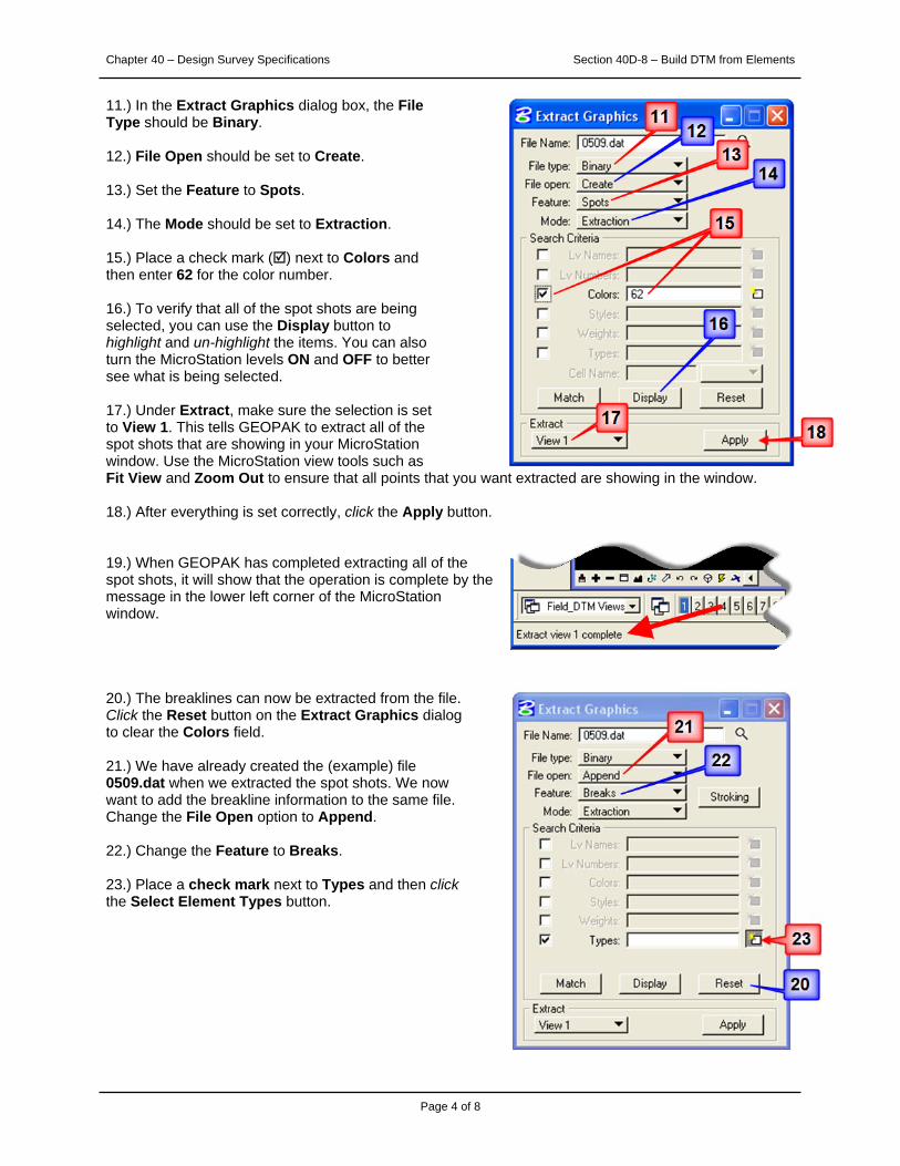
11.) In the Extract Graphics dialog box, the File Type should be Binary.
12.) File Open should be set to Create. 13.) Set the Feature to Spots.
14.) The Mode should be set to Extraction.
15.) Place a check mark () next to Colors and then enter 62 for the color number.
16.) To verify that all of the spot shots are being selected, you can use the Display button to highlight and un-highlight the items. You can also turn the MicroStation levels ON and OFF to better see what is being selected.
17.) Under Extract, make sure the selection is set to View 1. This tells GEOPAK to extract all of the spot shots that are showing in your MicroStation window. Use the MicroStation view tools such as Fit View and Zoom Out to ensure that all points that you want extracted are showing in the window.
18.) After everything is set correctly, click the Apply button.
19.) When GEOPAK has completed extracting all of the spot shots, it will show that the operation is complete by the message in the lower left corner of the MicroStation window.
20.) The breaklines can now be extracted from the file. Click the Reset button on the Extract Graphics dialog to clear the Colors field.
21.) We have already created the (example) file 0509.dat when we extracted the spot shots. We now want to add the breakline information to the same file. Change the File Open option to Append. 22.) Change the Feature to Breaks.
23.) Place a check mark next to Types and then click the Select Element Types button.
Chapter 40 – Design Survey Specifications Section 40D-8 – Build DTM from Elements
Page 5 of 8
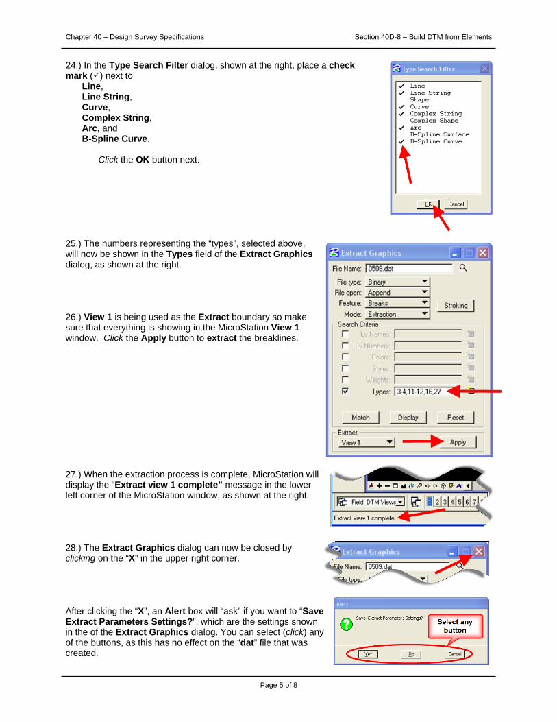
24.) In the Type Search Filter dialog, shown at the right, place a check mark () next to Line, Line String, Curve, Complex String, Arc, and B-Spline Curve.
Click the OK button next.
25.) The numbers representing the “types”, selected above, will now be shown in the Types field of the Extract Graphics dialog, as shown at the right.
26.) View 1 is being used as the Extract boundary so make sure that everything is showing in the MicroStation View 1 window. Click the Apply button to extract the breaklines.
27.) When the extraction process is complete, MicroStation will display the “Extract view 1 complete” message in the lower left corner of the MicroStation window, as shown at the right.
28.) The Extract Graphics dialog can now be closed by clicking on the “X” in the upper right corner.
After clicking the “X”, an Alert box will “ask” if you want to “Save Extract Parameters Settings?”, which are the settings shown in the of the Extract Graphics dialog. You can select (click) any of the buttons, as this has no effect on the “dat” file that was created.

Chapter 40 – Design Survey Specifications Section 40D-8 – Build DTM from Elements
Page 6 of 8
The TIN file 29.) The “.dat” filename (0509 in this example) will correspond to your project SAP number. File 0509.dat is now complete. The file contains all of the XYZ data necessary to build a TIN from the spot shots and breaklines. The TIN will now be created from this file. From the Survey tool bar, select DTM > Build DTM > From DAT File, as shown at the right. This will open the Build Triangles dialog. 30.) In the Build Triangles dialog, confirm that the Data File field contains the same “dat” file name as the one just created. If it doesn’t, click on the Data File Magnifying Glass icon ( ) and select the correct one. 31.) In the TIN file field, click the Magnifying Glass Browse icon ( ), as located by the blue arrow, to select the name of the TIN file that is about to be created.
32.) In the TIN File dialog, make sure the correct folder is chosen in the Directories window, shown by the blue arrow at the right.
33.) Enter the SAP number as the name of the TIN file, as shown by the red arrow.
34.) Click the OK button, shown by the black arrow. 35.) As shown in the Build Triangles dialog at the right, select Side for the Dissolve Option.
36.) Enter the value of 100 for the Side Length. This number represents the maximum length of any side of the triangles about to be created in the TIN file. You can adjust this number to eliminate as many unwanted exterior triangles as possible. 37.) When complete, click the Process button.

Chapter 40 – Design Survey Specifications Section 40D-8 – Build DTM from Elements
Page 7 of 8
38.) To view the TIN file that you just created, select DTM > Load DTM Features from the Survey tool bar, as shown at the right. This will open the Load DTM Features dialog.
39.) On the Load DTM Features dialog, select File > Open, as shown at the right. This will open the Open Preferences File dialog, as shown below.
40.) In the Open Preferences File dialog, navigate to the following location: W:\Highway\Design\CADD\Geopak\Survey\SeedFiles\GEOPAKSurvey\LoadDTM, as shown at the right.
41.) Select file IDOTSurvey.lpf and then click the Open button.
Chapter 40 – Design Survey Specifications Section 40D-8 – Build DTM from Elements
Page 8 of 8
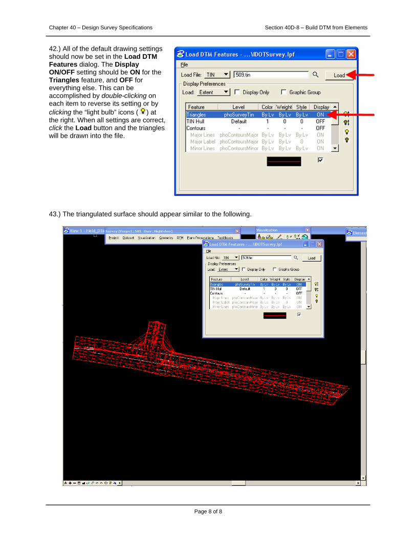
42.) All of the default drawing settings should now be set in the Load DTM Features dialog. The Display ON/OFF setting should be ON for the Triangles feature, and OFF for everything else. This can be accomplished by double-clicking on each item to reverse its setting or by clicking the “light bulb” icons ( ) at the right. When all settings are correct, click the Load button and the triangles will be drawn into the file.
43.) The triangulated surface should appear similar to the following.

Chronology of Changes to Design Manual Section:
040D-008 Build DTM from Elements9/30/2011 NEW
New

![Overview and Scutiny Power BI slides.pptx [Read-Only]€¦ · Dtm 4 Consultant Pod g Dtm I Dtm 8 7 Dtm 3 8 7 Dtm 6 Dtm Pod 4 8 Dtm Pod 4 5 Dtm 2 8 Dtm Pod 8 Dtm I 7 Dtm 4 Dtm Pod](https://static.fdocuments.in/doc/165x107/5fb41d34b5c9a8274925974c/overview-and-scutiny-power-bi-read-only-dtm-4-consultant-pod-g-dtm-i-dtm-8-7-dtm.jpg)