Budapest, Hungary, 3-7 October 2017 - fao.org · Published Cadaster information on land use...
19
1 DEALING WITH LAND ABANDONMENT Budapest, Hungary, 3-7 October 2017 9 th International LANDNET Workshop Crina Turtoi, senior researcher Institute of Agricultural Economics of the Romanian Academy 2 Presentation Structure 1. Romania – basic information 2. Trend in utilization of farm land, by main land use categories 3. Sources of information on farm land abandonment a) Statistical indicators b) Land registration system 4. Drivers of land abandonment 5. Supporting measures to mitigate land abandonment occurrence
Transcript of Budapest, Hungary, 3-7 October 2017 - fao.org · Published Cadaster information on land use...
1
DEALING WITH LAND ABANDONMENT
Budapest, Hungary, 3-7 October 2017
9th
International LANDNET Workshop
Crina Turtoi, senior researcher
Institute of Agricultural Economics of the Romanian Academy
2
Presentation Structure
1. Romania – basic information
2. Trend in utilization of farm land, by main land use categories
3. Sources of information on farm land abandonment
a) Statistical indicators
b) Land registration system
4. Drivers of land abandonment
5. Supporting measures to mitigate land abandonment
occurrence
2
3
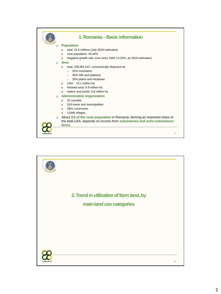
1. Romania –Basic information
Population
total: 21.6 millions (July 2016 estimates)
rural population: 45.44%
Negative growth rate, ever since 1992 (-0.32%, as 2016 estimates)
Area
total: 238,391 km2, concentrically disposed as:
o 31% mountains
o 36% hills and plateaus
o 33% plains and meadows
UAA: 13.1 million ha
forested area: 6.9 million ha
waters and ponds: 0.8 million ha
Administrative organization
42 counties
319 towns and municipalities
2851 communes
12946 villages
About 2/3 of the rural population in Romania, farming an important share of
the total UAA, depends on income from subsistence and semi-subsistence
farms.
4
2. Trend in utilization of farm land, by
main land use categories
3
5
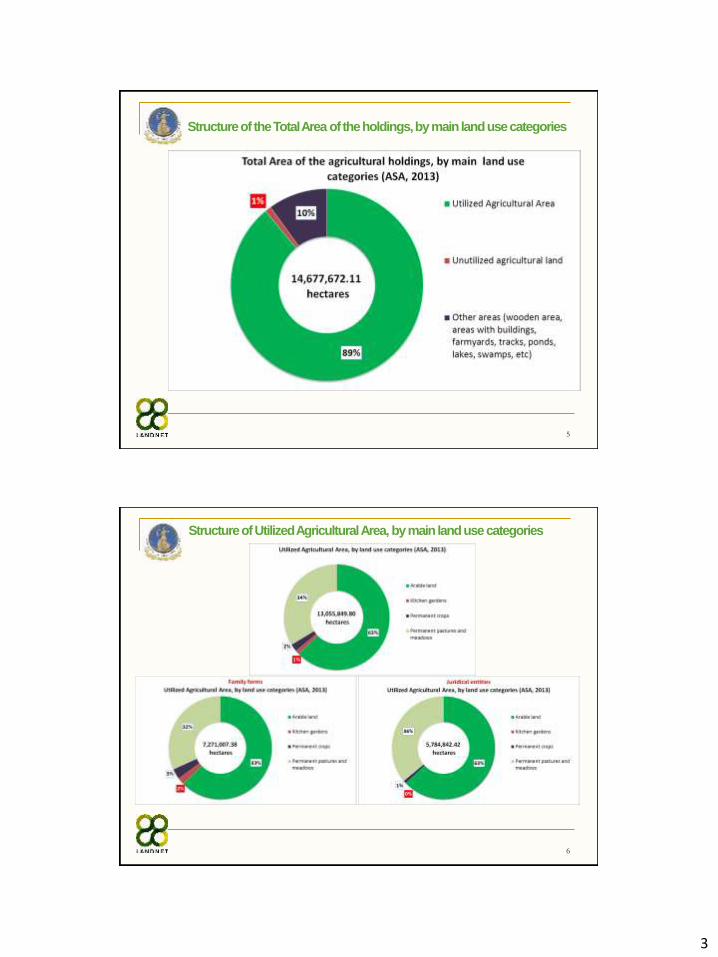
Structure of the Total Area of the holdings, by main land use categories
6
Structure of Utilized Agricultural Area, by main land use categories
4
7
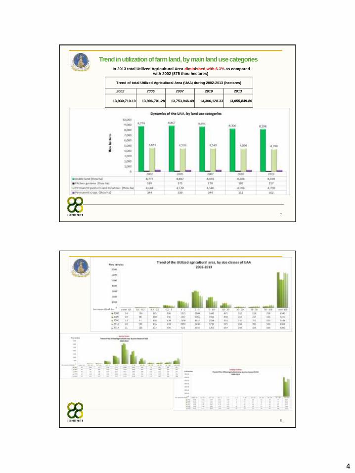
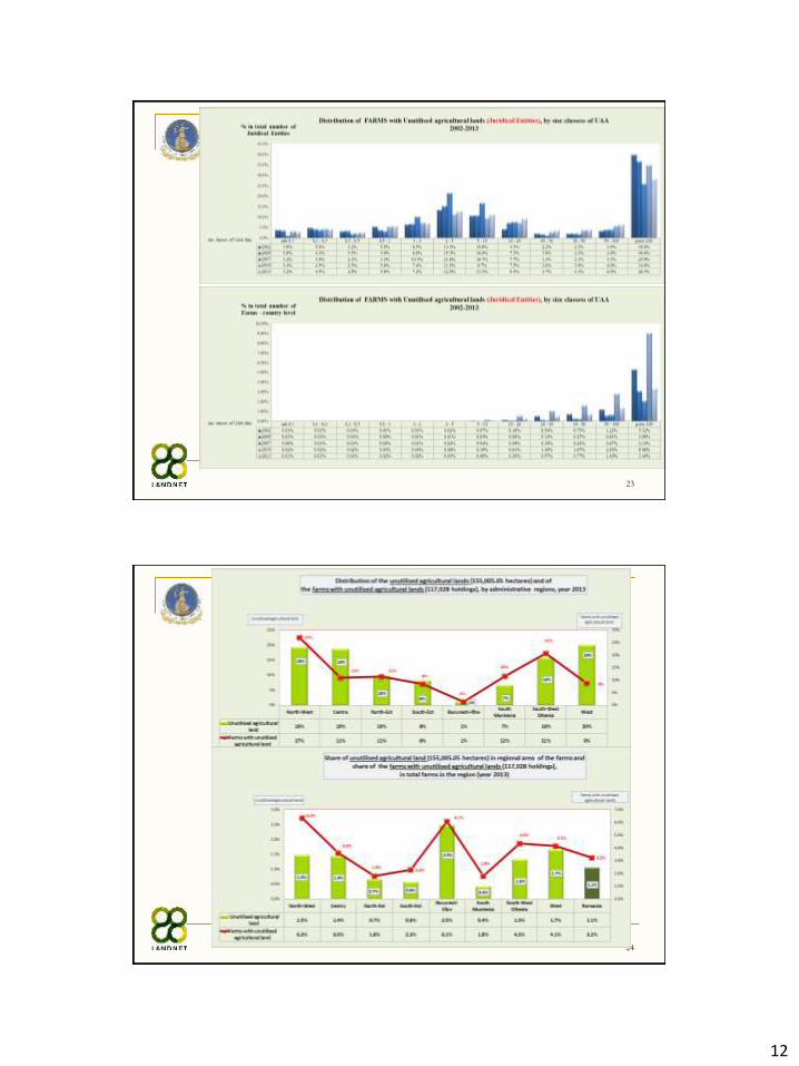
In 2013 total Utilized Agricultural Area diminished with 6.3% as compared
with 2002 (875 thou hectares)
Trend in utilization of farm land, by main land use categories
2002 2005 2007 2010 2013
13,930,710.10 13,906,701.28 13,753,046.49 13,306,128.33 13,055,849.80
Trend of total Utilized Agricultural Area (UAA) during 2002-2013 (hectares)
8
5
9
10

6
11
12
7
13
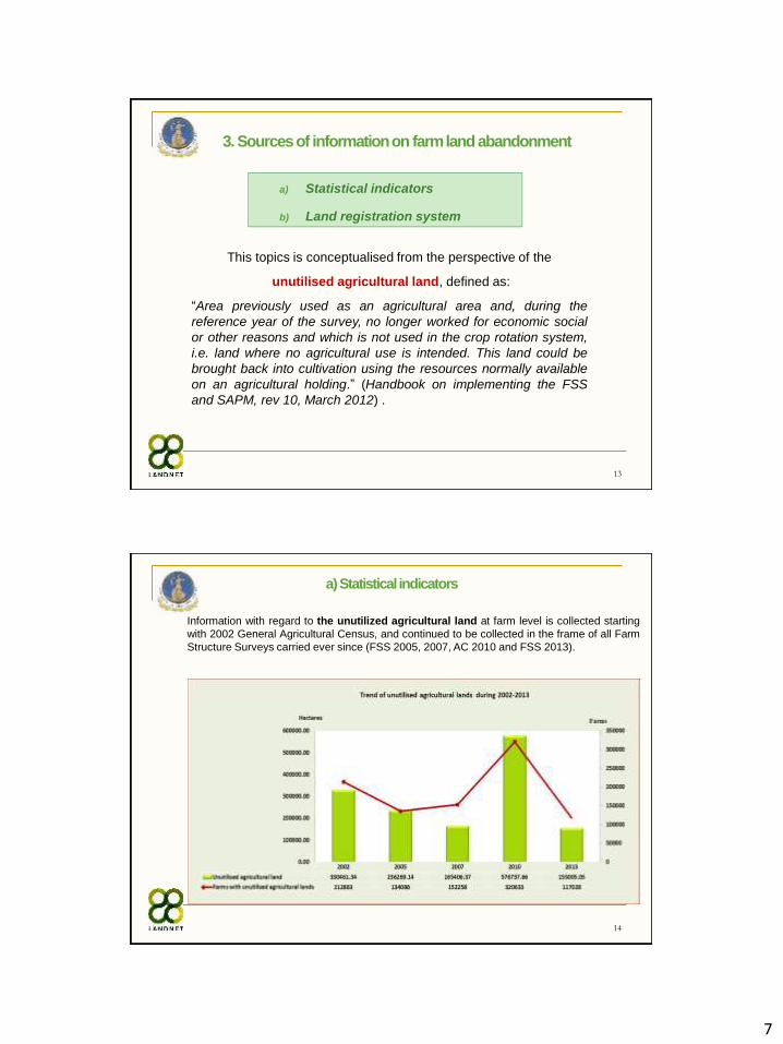
3. Sources of information on farm land abandonment
This topics is conceptualised from the perspective of the
unutilised agricultural land, defined as:
“Area previously used as an agricultural area and, during the
reference year of the survey, no longer worked for economic social
or other reasons and which is not used in the crop rotation system,
i.e. land where no agricultural use is intended. This land could be
brought back into cultivation using the resources normally available
on an agricultural holding.” (Handbook on implementing the FSS
and SAPM, rev 10, March 2012) .
a) Statistical indicators
b) Land registration system
14
a) Statistical indicators
Information with regard to the unutilized agricultural land at farm level is collected starting
with 2002 General Agricultural Census, and continued to be collected in the frame of all Farm
Structure Surveys carried ever since (FSS 2005, 2007, AC 2010 and FSS 2013).
8
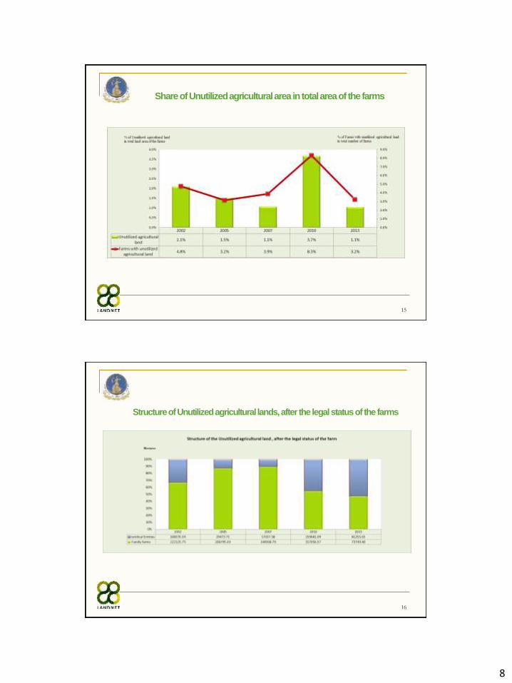
15
Share of Unutilized agricultural area in total area of the farms
16
Structure of Unutilized agricultural lands, after the legal status of the farms
9
17
Structure of the Farms with Unutilized agricultural lands, after the legal status of the farms
18
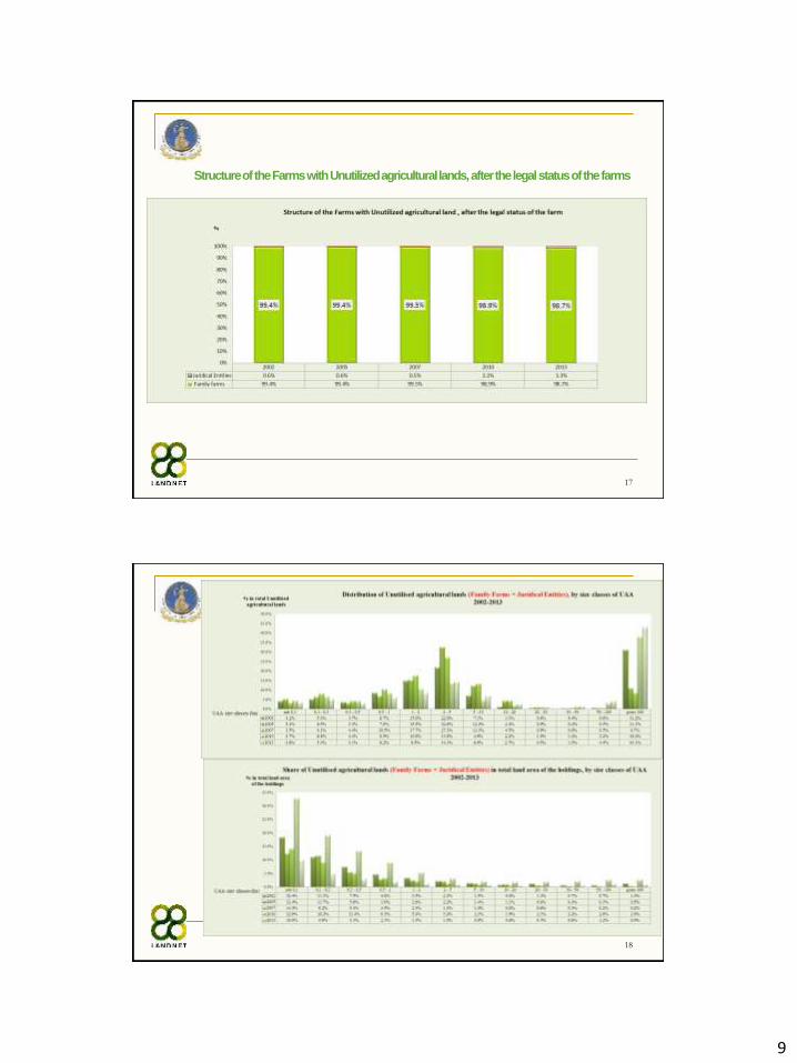
10
19
20
11
21
22
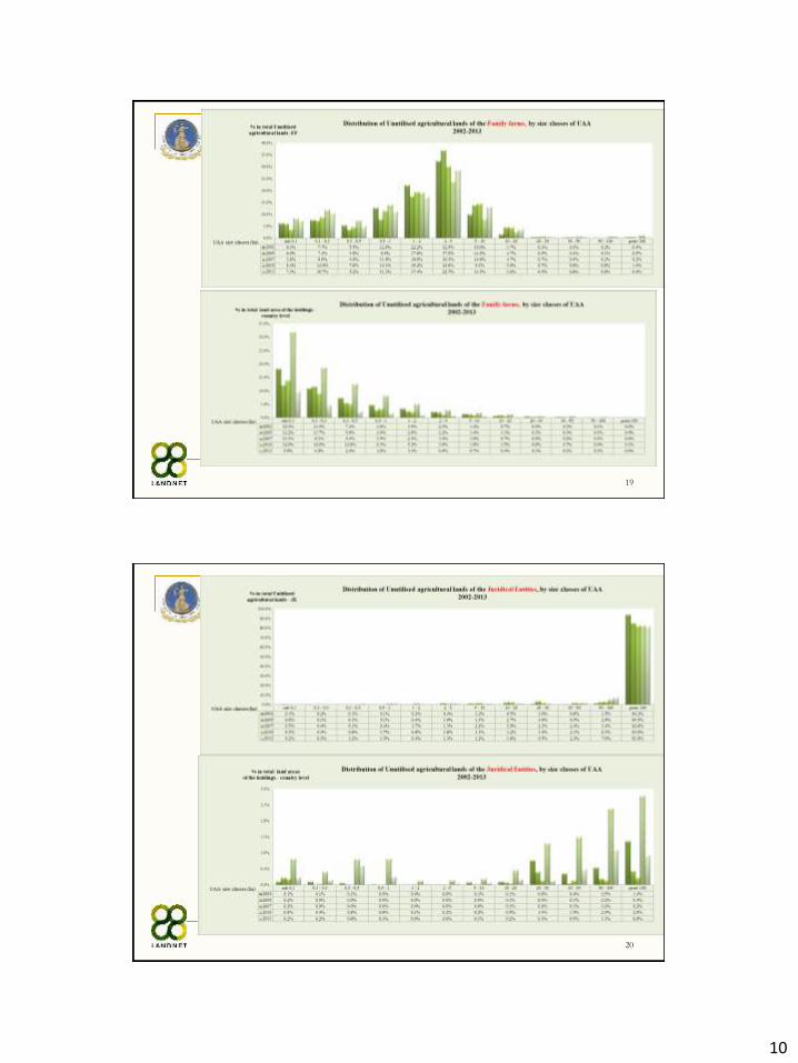
12
23
24
13
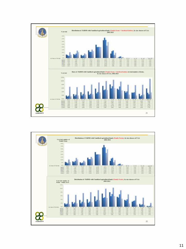
25
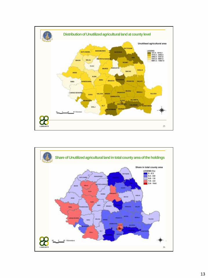
Distribution of Unutilized agricultural land at county level
26
Share of Unutilized agricultural land in total county area of the holdings
14
27
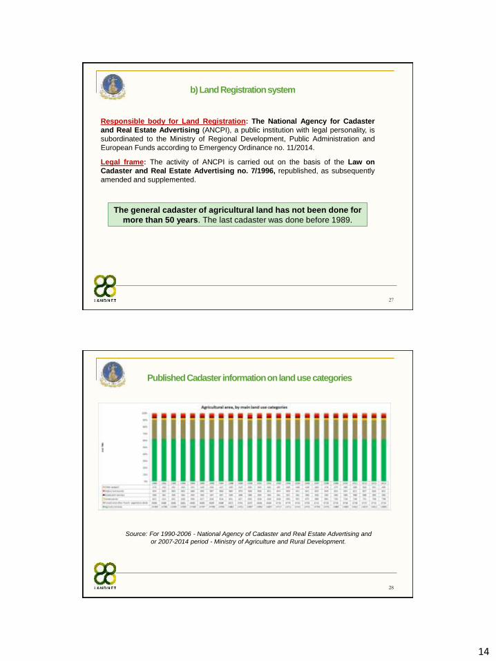
The general cadaster of agricultural land has not been done for
more than 50 years. The last cadaster was done before 1989.
Responsible body for Land Registration: The National Agency for Cadaster
and Real Estate Advertising (ANCPI), a public institution with legal personality, is
subordinated to the Ministry of Regional Development, Public Administration and
European Funds according to Emergency Ordinance no. 11/2014.
Legal frame: The activity of ANCPI is carried out on the basis of the Law on
Cadaster and Real Estate Advertising no. 7/1996, republished, as subsequently
amended and supplemented.
b) Land Registration system
28
Published Cadaster information on land use categories
Source: For 1990-2006 - National Agency of Cadaster and Real Estate Advertising and
or 2007-2014 period - Ministry of Agriculture and Rural Development.
15
29
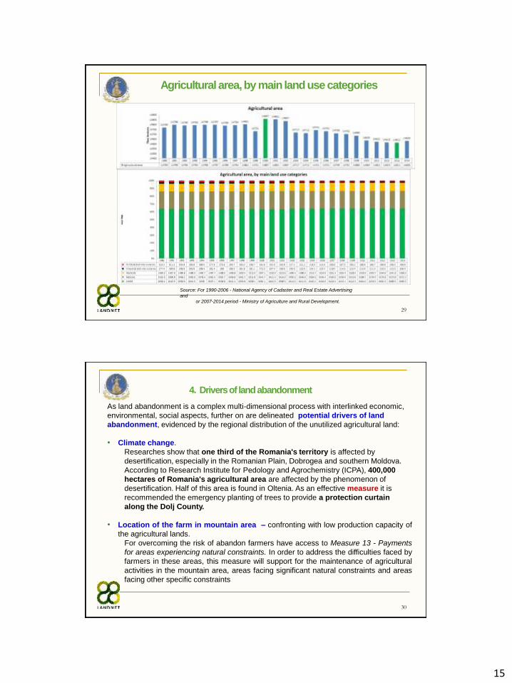
Agricultural area, by main land use categories
Source: For 1990-2006 - National Agency of Cadaster and Real Estate Advertising
and
or 2007-2014 period - Ministry of Agriculture and Rural Development.
30
4. Drivers of land abandonment
As land abandonment is a complex multi-dimensional process with interlinked economic,
environmental, social aspects, further on are delineated potential drivers of land
abandonment, evidenced by the regional distribution of the unutilized agricultural land:
• Climate change.
Researches show that one third of the Romania's territory is affected by
desertification, especially in the Romanian Plain, Dobrogea and southern Moldova.
According to Research Institute for Pedology and Agrochemistry (ICPA), 400,000
hectares of Romania's agricultural area are affected by the phenomenon of
desertification. Half of this area is found in Oltenia. As an effective measure it is
recommended the emergency planting of trees to provide a protection curtain
along the Dolj County.
• Location of the farm in mountain area – confronting with low production capacity of
the agricultural lands.
For overcoming the risk of abandon farmers have access to Measure 13 - Payments
for areas experiencing natural constraints. In order to address the difficulties faced by
farmers in these areas, this measure will support for the maintenance of agricultural
activities in the mountain area, areas facing significant natural constraints and areas
facing other specific constraints
16
31
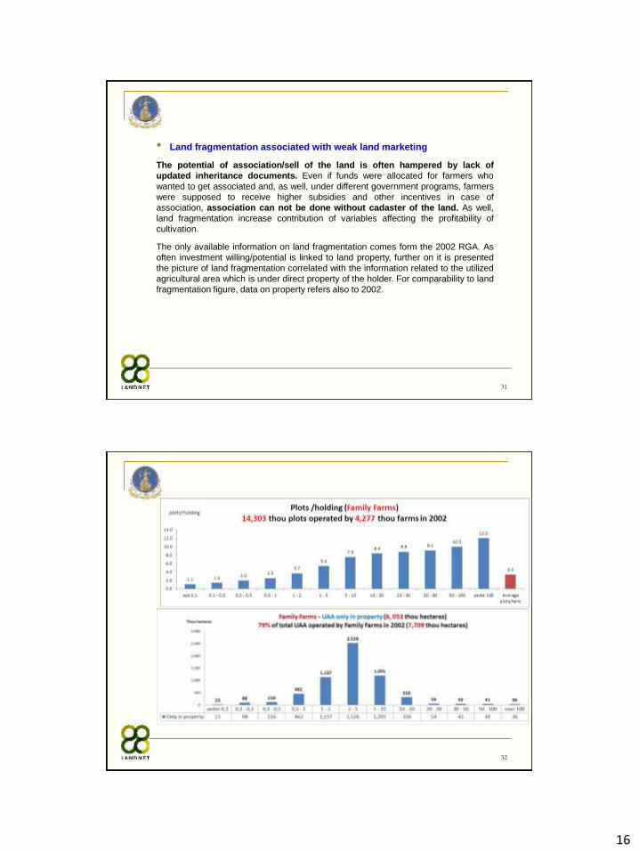
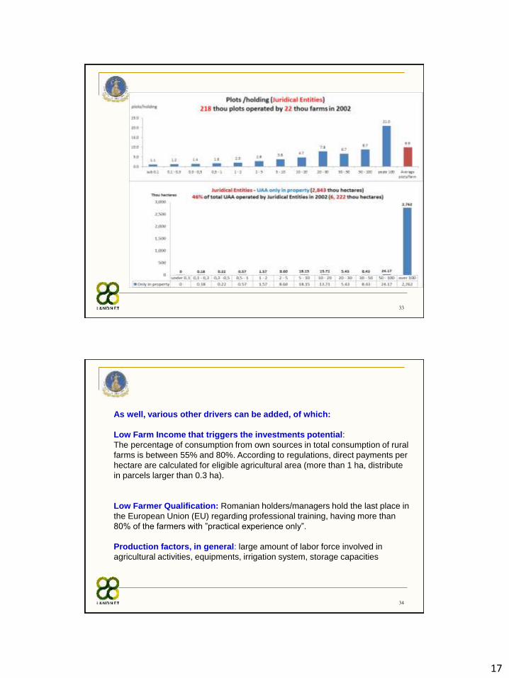
• Land fragmentation associated with weak land marketing
The potential of association/sell of the land is often hampered by lack of
updated inheritance documents. Even if funds were allocated for farmers who
wanted to get associated and, as well, under different government programs, farmers
were supposed to receive higher subsidies and other incentives in case of
association, association can not be done without cadaster of the land. As well,
land fragmentation increase contribution of variables affecting the profitability of
cultivation.
The only available information on land fragmentation comes form the 2002 RGA. As
often investment willing/potential is linked to land property, further on it is presented
the picture of land fragmentation correlated with the information related to the utilized
agricultural area which is under direct property of the holder. For comparability to land
fragmentation figure, data on property refers also to 2002.
32
17
33
34
As well, various other drivers can be added, of which:
Low Farm Income that triggers the investments potential:
The percentage of consumption from own sources in total consumption of rural
farms is between 55% and 80%. According to regulations, direct payments per
hectare are calculated for eligible agricultural area (more than 1 ha, distribute
in parcels larger than 0.3 ha).
Low Farmer Qualification: Romanian holders/managers hold the last place in
the European Union (EU) regarding professional training, having more than
80% of the farmers with ”practical experience only”.
Production factors, in general: large amount of labor force involved in
agricultural activities, equipments, irrigation system, storage capacities
18
35
5. Supporting measures to mitigate land abandonment occurrence
Legislative frame for systematic registration work on cadaster:
According to the 2017 updates and amendments to the Law 7/1996, “until
December 31, 2017, at least one cadastral office and real estate publicity
office, referred to as a territorial office or, as the case may be, a public
relations office, will be set up and will operate at the level of district court
as units without legal personality, subordinated to the territorial offices”.
Main objective of latest 2017 amendments to Law7/1996: to carry out
systematic registration work on cadastral sectors under the National Cadaster
and Land Book Program 2015-2023 (PNCCF) for free registration of all real
estates (land, buildings and apartments) in Romania in the Integrated
Cadaster System and Land Book. The program is funded from ANCPI's own
revenues - over four billion lei, but also from external funds obtained through
the Regional Operational Program, amounting to more than 300 million euros.
36
Supporting measures to mitigate land abandonment occurrence (cont.)
Agricultural Register
According to Law no. 54/2017 amending and supplementing the Government
Ordinance no. 28/2008 on the agricultural register, staring with from 1 January
2018, the Agricultural Register shall be filled in and kept up to date in electronic
format.
Taxation:
A new rule to support farmers working the farmland, but also to “sanction"
those who leave the land for two consecutive years.
According to a draft ordinance to complete Law no. 277/2015 regarding the
Fiscal Code, published on the website of the Ministry of Public Finance (MFP),
the owners of agricultural land will be exempted from the tax on the land. As
well, for non-cultivated agricultural lands for two consecutive years the tax will
be increased by the Local Council with up to 100 lei/ ha, starting with the third
year.
19
37
Area under successful land management contributing to bio diversity and high
nature value farming/forestry, water quality, mitigating climate change, soil quality,
avoidance of marginalization and land abandonment
Source: Ex-post evaluation of NRDP 2007-2013
a) bio-
diversity
b) water
quality
c) mitigating
climate
change
d) soil quality
e) avoidance of
marginalization
and land
abandonment
211
212
Support for Mountain Areas
Support for Less favoured
Areas – other than
Mountain Areas
4,169,931.00 0 0 521,440.43 4,169,931.00
214Agri-environment
payments1,903,376.07 2,186,400.82 1,431,351.70 342,686.43 1,843,714.39
221First afforestation of the
agricultural lands0.00 0.00 0.00 50.00 0.00
6,073,307.07 2,186,400.82 1,431,351.70 864,176.86 6,013,645.39
Area (hectares) under succesful land management contributing to:
Related measure
TOTAL
38
Thank You for Your Attention!