Buckminster Estate - South Kesteven District Council...
19
Buckminster Estate Spitalgate Heath SUE ENVIRONMENTAL STATEMENT CHAPTER 4.0 SOCIO ECONOMICS July 2014
Transcript of Buckminster Estate - South Kesteven District Council...

Buckminster Estate
Spitalgate Heath SUE
ENVIRONMENTAL STATEMENT
CHAPTER 4.0 SOCIO ECONOMICS
July 2014

Spitalgate Heath SUE Environmental Statement – C4 Socio Economics
1
1.0 INTRODUCTION
Background
1.1 This Socio Economic Impact Assessment accompanies an outline planning application by the
Buckminster Estate for the development of the Spitalgate Heath Sustainable Urban Extension
(SHSUE) at South Grantham. This project is intended to deliver a sustainable new community in
a high-quality landscape setting, providing much needed new homes, employment space, a
variety of community facilities and a new link road, the Southern Quadrant Link Road, (which will
form part of the Grantham Southern Relief Road, which will connect the A1 with the A52), on land
to the south of Grantham. The extent of the site is shown on the plan within Appendix A.
1.2 This report presents the predicted socio-economic effects, arising from the proposed
development of the SHSUE. It forms a part of the Environmental Statement, which in turn is
submitted as part of the outline planning application for the SHSUE.
Policy Context
1.3 Grantham was awarded Growth Point Status by Central Government in 2007 and as a
consequence, the town will be a focus for significant and sustainable population and economic
growth. The development of new housing, employment premises and provision of jobs will be
supported by significant investment in retail provision, as well the social and physical
infrastructure required to meet the needs of the increased population.
1.4 Growth Point Status has underpinned planning and economic regeneration strategies for
Grantham over the past 7 years. In the adopted South Kesteven District Council Core Strategy,
and in the draft Grantham Area Action Plan, the application site between the B1174 Spittlegate
Level and the A52 Somerby Hill in Grantham has been identified as the site for a new sustainable
mixed-use urban extension which is referred to in those documents as the Grantham Southern
Quadrant (GSQ) but for the purposes of this outline planning application is also known as the
Spitalgate Heath Sustainable Urban Extension (SHSUE). The Plan has the objective of the site
providing up to 3,700 new dwellings, new schools, medical facilities, a community centre,
employment opportunities, a neighbourhood centre and a range of formal and informal public
open spaces.
1.5 In February 2013, South Kesteven District Council (SKDC) adopted the Grantham Southern
Quadrant Masterplan as formal supplementary planning guidance (SPD). The proposals in this
outline planning application, including its submitted Development Parameters Plan, follow the
guidance in the SPD for the formulation of development proposals for the SHSUE.
1.6 South Kesteven’s Economic Development Strategy (2012 – 2016) points out that the SHSUE
provides Grantham with an opportunity to address some of the issues that have constrained the
local economy to date such as the need to attract more high quality, skilled jobs to the town to
prevent the ‘leakage’ of skilled labour, particularly professional, out of the town as well as
attracting new highly-skilled residents.
The Proposed Development
1.7 The SHSUE proposed scheme is defined by the Development Parameters Plan which is shown
as Appendix A. The component parts in terms of their approximate land coverage are as follows:

Spitalgate Heath SUE Environmental Statement – C4 Socio Economics
2
Residential use. Including market and affordable homes. 98.73 ha
Employment uses. B1, B2 and B8. 26.53ha
Local centre 2.02 ha
Community School 5.76 ha
Primary school 1.8 ha
Outdoor sports 7.69 ha
Allotments 2.0 ha
Other open space / green areas 47.45 ha
SQLR Corridor 17.6 ha
1.8 The location of the proposed principal employment component comprises two sites E1 and E2 on
the Development Parameters Plan with a total site area of 26.53 ha. They are located on the
western part of the site either side of where the Southern Quadrant Link Road meets the B1174
Spittlegate Level and this location conforms to the guidance in the SPD as the most appropriate
location for significant employment development.
1.9 It is not intended to be prescriptive at this stage about the precise form that the employment
areas might take. The intention is to have the flexibility to market the sites for a mix of B1
business, B2 industry and B8 storage and distribution investors and occupiers. Given the location
and topography of the land, it is likely that the employment areas will be developed in the style of
a business park with a range of plots for speculative development and owner occupiers. The
assumption is made that 26.53ha of the sites will be available for B1/B2 and B8 development.
Assuming a site floor space density of some 40% then the 26.53 ha has the capacity to generate
up to 110,000 m2 of floor space (GEA).
1.10 The proposed Local Centre occupies a 2 ha plot shown as ‘LC’ on the Development Parameters
Plan and is likely to comprise a range of A1-A5 retail, B1, police room, D1 non-residential
institutional uses and D2 community leisure uses. This is likely to generate approximately
8,000m2 (GEA) of floor space. In addition, there will be a secondary school and a primary school
within the development which will both generate employment for professional and support staff.
1.11 The EIA Regulations identify the need to describe:
“aspects of the environment likely to be significantly affected by the development, including, in
particular, population… (and) material assets”.
1.12 This assessment will consider the following issues:
Population
Housing
Education
Health
Community Facilities
Open Space

Spitalgate Heath SUE Environmental Statement – C4 Socio Economics
3
The Economy
1.13 Section 2 of this chapter sets out the baseline conditions for the study area. Section 3 identifies
the potentially significant socio-economic effects of the proposed development and Section 4
provides a summary of mitigation measures. The final section includes the conclusions of the
assessment
2.0 BASELINE CONDITIONS
Population
2.1 Grantham is the largest town in South Kesteven District and has a population of approximately
41,600 (2011 Census, based upon the wards listed within the table below). However, the
population is anticipated to grow to up to around 60,000 by 2026 as a result of the delivery of
increased housing growth. Grantham’s designation as a Growth Point provides the town with an
opportunity to realise its potential as a Sub-Regional Centre.
2.2 According to the 2011 Census, the population of South Kesteven District is 133,788.The
populations of the main wards in Grantham are as follows:
NAME OF WARD 2011 CENSUS
POPULATION 2001 CENSUS POPULATION
Belmont 5133 4335
Earlsfield 7332 7049
Greyfriars 4084 3887
Green Hill 4193 3825
Grantham St Johns 6078 4303
Harrowby 5852 6144
St Annes 4887 4548
St. Wulframs 4056 4148
TOTAL 41,615 38,239
Source: Office for National Statistics

Spitalgate Heath SUE Environmental Statement – C4 Socio Economics
4
2.3 Below is a plan showing the main wards (shaded yellow) which make up the town of Grantham:
Source: Office for National Statistics
2.4 It should be noted that the table and plan (above) include the ward of ‘Belmont’. Although this
ward covers a wide area of land to the east of Grantham, outside of the town, most of the
population of the ward is within the town, within areas immediately to the north of Harrowby
Ward. There are only more limited settlements within this ward, outside of the Grantham urban
area.
2.5 A breakdown of the percentages of different age groups across the District is shown below:
AGE BAND SOUTH KESTEVEN LINCOLNSHIRE ENGLAND AND WALES
Age 0 to 4 5.6 5.2 6.2
Age 5 to 7 3.2 3 3.4
Age 8 to 9 2.2 1.9 2.2
Age 10 to 14 6.2 5.7 5.8
Age 15 1.4 1.3 1.2
Age 16 to 17 2.6 2.4 2.5
Age 18 to 19 2.1 2.5 2.6
Age 20 to 24 4.7 5.8 6.8
Age 25 to 29 5.1 5.5 6.8
Age 30 to 44 19.2 18 20.5
Age 45 to 59 21.6 20.6 19.4
Age 60 to 64 7.2 7.4 6
Age 65 to 74 10.3 11.2 8.7
Age 75 to 84 6.1 6.8 5.6
Age 85 to 89 1.8 1.7 1.5
Age 90 and Over 0.9 0.9 0.8
Source: 2011 Census, ONS
Spitalgate Heath SUE Environmental Statement – C4 Socio Economics
5
2.6 The above table shows that the District has a lower than (national) average population in the 20-
24, 25-29 and 30-44 age ranges, indicating a lower than average ‘working age’ population. The
District has a higher than (national) average population in all age ranges over 60 years.
2.7 Comparisons between 2001 and 2011 Census data for South Kesteven District, shows that there
has been an increase in the proportion of the population aged 60 – 90 years and over. At the
same time, the district has seen a fall in the proportion of the population aged between 25 and 44
years.
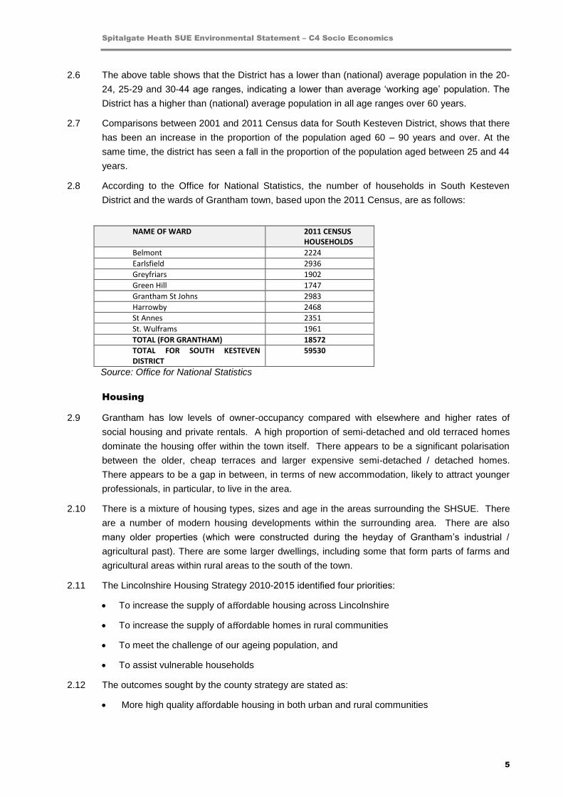
2.8 According to the Office for National Statistics, the number of households in South Kesteven
District and the wards of Grantham town, based upon the 2011 Census, are as follows:
NAME OF WARD 2011 CENSUS HOUSEHOLDS
Belmont 2224
Earlsfield 2936
Greyfriars 1902
Green Hill 1747
Grantham St Johns 2983
Harrowby 2468
St Annes 2351
St. Wulframs 1961
TOTAL (FOR GRANTHAM) 18572
TOTAL FOR SOUTH KESTEVEN DISTRICT
59530
Source: Office for National Statistics
Housing
2.9 Grantham has low levels of owner-occupancy compared with elsewhere and higher rates of
social housing and private rentals. A high proportion of semi-detached and old terraced homes
dominate the housing offer within the town itself. There appears to be a significant polarisation
between the older, cheap terraces and larger expensive semi-detached / detached homes.
There appears to be a gap in between, in terms of new accommodation, likely to attract younger
professionals, in particular, to live in the area.
2.10 There is a mixture of housing types, sizes and age in the areas surrounding the SHSUE. There
are a number of modern housing developments within the surrounding area. There are also
many older properties (which were constructed during the heyday of Grantham’s industrial /
agricultural past). There are some larger dwellings, including some that form parts of farms and
agricultural areas within rural areas to the south of the town.
2.11 The Lincolnshire Housing Strategy 2010-2015 identified four priorities:
To increase the supply of affordable housing across Lincolnshire
To increase the supply of affordable homes in rural communities
To meet the challenge of our ageing population, and
To assist vulnerable households
2.12 The outcomes sought by the county strategy are stated as:
More high quality affordable housing in both urban and rural communities

Spitalgate Heath SUE Environmental Statement – C4 Socio Economics
6
Closer working between partners to provide a more effective service for local people,
including a well-informed evidence base
A wider range of choices for older, vulnerable or homeless people
Communities, economies and existing homes that are more sustainable
2.13 The South Kesteven Housing Strategy (2013 – 2018) notes that the ageing population of the
district “presents challenges for the housing strategy”. The proportion of the population of the
district who are over the age of 65 is forecast to increase from 19.2% (2012) to 28% by 2020.
2.14 The Strategy states that it will be important “to ensure that any new house building across all
tenures and market sectors, and particularly in the district’s growth areas of North West
Quadrant/Poplar Farm and the South West Quadrant, provide appropriate responses to both the
range and extent of identified housing need”.
Education
2.15 Appendix B provides details of existing education provision in Grantham.
2.16 The town’s workforce is relatively well qualified compared with elsewhere, although there are
some issues of basic skills requirements with a high proportion of the working age population
having no qualifications. However, many of the higher skilled local people make use of the
town’s excellent transport links and travel out of the town to work, as demonstrated by the fact
that resident-based earnings are significantly higher than workplace earnings. The town also
struggles to retain many of its skilled younger graduates.
2.17 According to projections within the Lincolnshire County Council’s School Organisation Plan 2012
(January 2013), the number of pupils in Lincolnshire primary schools is forecast to rise by 4,282
between 2011/12 and 2015/16. The number of pupils in secondary schools is predicted to
decrease by 3432 between 2011/12 and 2014/15. However, it should be stressed that these
projections are at a ‘county’ level.
2.18 Data within the 2012 Lincolnshire School Organisation Plan suggests that, as of January 2013,
there was a surplus of primary school places in Grantham (based upon the schools listed above)
of 406 places and a surplus of secondary school places in Grantham (based upon the schools
listed above) of 398 places.
2.19 It should be noted that these figures include temporary mobile accommodation, and so the
figures are not a reflection of the permanent capacity of schools. In addition, some of the schools
with high numbers of surplus places, such as the Ruskin Priory Academy, are located some
distance from the SHSUE site
Health
2.20 The site is within the jurisdiction of the South West Lincolnshire Clinical Commissioning Group.
Appendix C provides details of the existing provision of health facilities in Grantham.
2.21 Grantham has a hospital with ‘accident and emergency’ facilities, combined with the number of
GP surgeries present in the town. The SHSUE will create additional demand for new healthcare
facilities.

Spitalgate Heath SUE Environmental Statement – C4 Socio Economics
7
Leisure
2.22 Dysart Park located on Houghton Road is the nearest park to the SHSUE. It includes a formal
park (2 hectares) and playing field. Facilities include:
Outdoor paddling pool
Bowling green (privately managed)
Hard tennis court
Bandstand
Flower and shrub beds
Children's play area
2.23 Parts of the park are currently being refurbished / undergoing improvement. The park provides
pedestrian links between the Riverside walk to the town centre and existing residential areas to
the north of the South Grantham SUE site.
2.24 There is a major leisure centre (Meres Leisure Centre) on Trent Road, approximately 3km to the
north east the site. It is managed by Leisure in the Community Ltd, working in partnership with
South Kesteven District Council. This extensive facility provides the following facilities:
Crèche
Four swimming pools
Main sports hall / smaller hall
Climbing wall
Table tennis Centre
Health & fitness facilities
Floodlit synthetic facilities / turf pitches
Football facilities
Athletics track
Tennis courts
2.25 In addition, the South Kesteven Sports Stadium is also located on Trent Road. This is an all-
weather 400m track with 8 lanes, and is the home to Grantham Town Football Club.
2.26 The South Kesteven Open Space Study (2009) notes that, in contrast to the situation for the
District as a whole, the space devoted to Parks, Gardens and Recreation Grounds is relatively
small in the Grantham urban area. However, the Study also notes that the space devoted to
allotments is higher in relative terms. Most of the allotment sites are ‘private’ and not in the
control of a public body. Education land is still the largest category in terms of space provided.
2.27 It is therefore concluded that the level of space for parks, gardens and recreation grounds in
Grantham town could be improved by a large scheme such as Spitalgate Heath.
2.28 Appendix C also provides details of community buildings and places of worship in the town.

Spitalgate Heath SUE Environmental Statement – C4 Socio Economics
8
The Local Economy
2.29 Grantham has had a long association with the engineering industry, and its manufacturing base
continues to expand and diversify along with food processing, cold storage, distribution,
agriculture, local government and the NHS, the MOD, tourism and the service sectors.
2.30 According to the Lincolnshire Sustainable Community Strategy (South Kesteven Chapter), much
of the employment within the district, however, has historically been low paid with low skill levels
and the average incomes are distorted by very high incomes of those commuting out of the
district.
2.31 Grantham town centre has traditionally had a role as a trading centre, particularly along the high
street where a significant number of retailers are located. Currently there is a relatively high retail
vacancy rate.
2.32 Commercial floor space rents remain relatively low. In addition, there is a lack of good quality
office supply within the town. There is no established business quarter within Grantham and
much of the office floor space which is available is not of a significant size or quality to be
attractive to many financial and business services companies. Because of a lack of good quality
supply, Grantham is not currently seen as a location of first choice for companies, who prefer to
locate elsewhere within the East Midlands. Without the quality of supply it is unlikely to develop
its business base in higher value sectors.
2.33 There are a number of major employers located within close proximity to the site. These include:
MOD: Prince William of Gloucester Barracks is home to HQ RLC TA & 5 Training Regiment,
RLC Regular and TA. The largest TA Unit in the British Army with approximately 2700
personnel in 7 Regiments and 9 Staff Units, this is a large and diverse military community.
The barracks is also home to 49(E) Bde Regional Training Centres (RTC)
South Kesteven District Council
Moy Park (poultry)
SG Baker Ltd (packaging)
The Woodland Trust
Grantham Book Services (distributors for independent publishers)
Genie Europe (plant: work lifts & platforms)
Environcom England Ltd – operates a facility immediately to the west of the site. It claims to
be the UK's largest independent electrical re-use and recycling specialist of waste electronic
and electrical equipment (WEEE)
Retail: Sainsburys, Morrisons, Asda, B&Q, Homebase and a large range of smaller retail
chains.
2.34 There are many additional businesses and other organisations located in the centre of Grantham.
2.35 72.7% (97,319) of the population of the District are residents aged between 16 and 74, according
to the 2011 Census. Of these:
72.2% (70,273) are economically active
3.3% (3248) are unemployed

Spitalgate Heath SUE Environmental Statement – C4 Socio Economics
9
2.6% (2526) are students (economically active)
3.2% (3113) are students (economically inactive)
16.5% (16,064) are retired
2.9% (2840) are classed as ‘long-term sick / disabled’
Retail
2.36 The site is close to the centre of Grantham, which provides a large number of shops,
supermarkets, public houses, restaurants, cafes, and leisure facilities. The main shopping streets
are located approximately 1.3km from the north of the site.
2.37 There is an Aldi foodstore, located to the west of South Parade, within 250m of the site. Adjacent
to this is a Dunelm Mill superstore and a Jacksons Building Centre. There is also a large
Sainsburys superstore together with a number of other retail units on London Road, some 800m
from the site. There is also another supermarket, a Morrisons superstore in the centre of the town
(to the north of Wharf Road), some 1.1 km from the site. In addition, there is a large ASDA
hypermarket (with petrol station and extensive non-food ranges) and a Lidl store located south of
Barrowby Road, just under 2km from the site.
2.38 There are a number of general retail units, convenience food retailers, and fast food restaurants
on Bridge End Road, a few hundred metres to the north of the site.
Transport Links
2.39 Grantham railway station is served by the East Coast Main Line (located between the main
stations for Peterborough and Newark Northgate), which links London Kings Cross with
Newcastle and stations north to Scotland (as far north as Inverness). The railway station is
approximately 1,000 metres from the site. Grantham is also on the Nottingham to Skegness
Line, and the Liverpool to Norwich Line. The town is located immediately east of the A1 strategic
highway. These road and rail connections make Grantham a logical location for commuting to
other towns and cities across the country.
2.40 There are many bus routes to, and within the area of, Grantham. In particular, route 28 runs
south along the B1174 from Grantham town centre to South Witham, along the western boundary
of the site. Routes 4 (to Stamford) and 26 (to Old Somerby) run from the town centre along the
northern boundary of the site (Somerby Hill).
Quality of Life
2.41 Grantham is generally an attractive place in which to live. The socio-economic profile (according
to the Lincolnshire Place Survey 2008) is such that the town has some of the most deprived
wards in the country and conversely some of the least deprived. In between there are plenty of
areas with successfully established families and others on lower incomes and dependent upon
benefits.
2.42 The town as a whole is a relatively safe place in which to live, with low crime rates, and a
relatively healthy population.
2.43 CACI Lifestyle data differentiates between residents in towns in the UK. Grantham has a
relatively high proportion of “Wealthy Executives” in the town, further indicating its desirability as

Spitalgate Heath SUE Environmental Statement – C4 Socio Economics
10
a place to live. The town is also home to a high proportion of “Affluent Greys” and “Flourishing
Families” compared with the national average. However the town is home to a lower proportion
of “Prosperous Professionals”, “Educated Urbanites” and “Starting Outs” than nationally. The
lack of local services, facilities and opportunities for younger residents is often seen as a reason
for their tendency to move away, once qualified.
Rationale for Growth
2.44 In 2007 Grantham was awarded Growth Point Status by the Government after successfully
bidding to secure growth point funding of £6 million from the Department for Communities and
Local Government. In order to secure this, South Kesteven District Council and Lincolnshire
County Council identified a strategy for the town’s future growth and development which set out
areas in which funding support from the Government would help to deliver the town’s growth
plans.
2.45 Grantham has many positive aspects, particularly regarding the quality of life that it can offer
residents, the lack of widespread deprivation within the town, the high economic activity rates and
the quality of its external transport links. In addition, a number of developments are already
proposed within the town, which would enhance its attractiveness as a place to live. Such factors
demonstrate the potential for Grantham to be a location for significant future growth.
2.46 Challenges faced by the town include:
The retention of younger skilled workers;
The provision of higher-paid higher skilled jobs in knowledge-based sectors;
The need for a higher-quality provision of commercial floor space;
Specific local transport and traffic issues (including congestion within the very centre of the
town) and other local service improvements;
A fragmented town centre offer; and
The lack of affordable housing to meet all requirements
2.47 If these issues are addressed through development and growth, Grantham could fulfil its potential
as a location of choice for a wide range of people and businesses.
3.0 POTENTIAL EFFECTS OF THE DEVELOPMENT
Introduction
3.1 Potential effects of the proposed SHSUE development considered within this section include:
Population impacts
Impacts on local education facilities
Impact upon medical facilities (doctors, hospitals etc)
Impact on the provision of leisure facilities
The local economy – number of jobs created through construction, employees, service and
retail spend
Out-commuting

Spitalgate Heath SUE Environmental Statement – C4 Socio Economics
11
Population
3.2 The development will accommodate up to 3,700 new houses. Using a multiplier of 2.4 (Average
number of people per household (2012 figures) according to the ONS), it is estimated that the
South Grantham SUE will accommodate an additional 8,880 residents once fully developed and
occupied, with an estimated economically active population of approximately 4,620 persons Were
the development to only accommodate 3,500 new houses, then a population of 8,400 could be
generated.
3.3 South Kesteven District Council has indicated that the current multiplier for the District is 2.3
(average number of people per household). Should this multiplier be used, then some 8,510
people would be generated for 3,700 homes or 8,050 people would be generated from 3,500 new
homes. It can therefore be concluded that the population generated from the development,
depending upon number of houses and multipliers used will be in the region of 8,050 to 8,800.
This report uses the ‘higher’ population generation scenario of 8,800 to illustrate the ‘greatest’
potential impact of the proposed development.
3.4 Based upon a population increase of 8,800 residents (3,700 new homes), the population of
Grantham could rise by up to 21.1% as a result of the SHSUE.
3.5 Taking the ONS figures from the 2011 Census for South Kesteven District as a whole, it is
possible to estimate the economic activity levels of the proposed development. 72.7% (97,319) of
the population of the District are residents aged between 16 and 74, according to the 2011
Census. Based upon a projected population of 8,800, it could be assumed (using this
percentage) that 6,398 people would be aged between 16 and 74 within the SHSUE. Of these, it
can be estimated that:
4,619 (rounded up to 4,620) people would be economically active
211 would be unemployed
166 would be students (economically active)
205 would be students (economically inactive)
1056 would be retired
186 would be classed as ‘long-term sick / disabled’
Housing
3.6 The addition of c. 3,700 new dwellings as part of the proposed development would increase the
housing stock of Grantham by approximately 21.1%.
3.7 A proportion of this new housing will be affordable, which is important as the Peterborough Sub-
Regional Strategic Housing Market Assessment (SHMA), March 2014 Draft Report, produced by
GL Hearn, identifies a “net need” for 343 units per annum of affordable housing within South
Kesteven District between 2013 and 2036. However it is likely that the proportion of affordable
homes will be lower than normal policy requirements as the scheme has to make a significant
contribution to the funding of the Southern Quadrant Link Road which will effect overall viability
and hence deliverability.

Spitalgate Heath SUE Environmental Statement – C4 Socio Economics
12
3.8 The Peterborough Sub-Regional SHMA also finds that there is a localised shortage of “smaller
family homes to support newly forming families” within Grantham (paragraph 8.29).
3.9 Paragraph 9.46 of the SHMA notes that “at Prince William of Gloucester Barracks, Grantham,
redeployments will create a modest need for additional family properties according to the MoD,
which it is intended to be purchased on the open market”. The SHMA also states that “there will
be some increase in affordable housing needs over time as the personnel deployed at…..
Grantham Barracks increase”. However, the SHMA stresses that the long term impact on market
housing numbers “will be quite minor and does not need to be reflected in the SHMA’s
modelling”. This is of relevance, given the location of the Barracks, to the north of the Spitalgate
Heath site.
Education
3.10 Increases in population will result in an increased demand for school places. As a result, new
schools will be needed. Other schools may have to expand. The development will have an
impact upon the following facilities:
Pre-school (nursery accommodation)
Primary schools
Secondary schools / post-16 education
3.11 All figures are based on information provided by Lincolnshire County Council using their
methodology for calculating generation of pupil numbers. More detailed calculations will be made
once the exact mix of house types / sizes is known. The LCC Pupil Product Ratios are shown
below:
BEDROOMS PRE-SCHOOL
PRIMARY SECONDARY
2 BED 0.09 0.09 0.10
3 BED 0.18 0.18 0.24
4 BED 0.26 0.29 0.28
TOTAL SAMPLE
0.16 0.18 0.20
3.12 As the mixture of different house sizes is unknown at the current time, figures for the ‘total
sample’ have been used, as an average, for projections within this section.
3.13 Based upon the table above, the development could generate demand for some 592 pre-school
places. Given the existing supply, this will require extra provision for some additional places in
the local area.
3.14 The proposed development once fully built out in 20 plus years is predicted to generate 666
primary school-aged children, which will result in a requirement for additional places within the
local area. As there is currently a surplus of 406 places (January 2013), it is likely that at least an
additional 260 places will be required, which would mean the construction of a new primary
school.
Spitalgate Heath SUE Environmental Statement – C4 Socio Economics
13
3.15 The proposed development is predicted to generate 740 secondary school- aged children, which
will result in an increase in required places across the town. As there is a currently surplus of
approximately 398 places (based upon the School Organisation Plan), it is likely that at least an
additional 342 places will be required. Therefore a new secondary school will be required.
3.16 The proposed development is also likely to generate some extra demand for sixth- form places.
Health
3.17 The additional population will result in the need for additional healthcare facilities. Discussions
are ongoing with the NHS South West Lincolnshire Clinical Commissioning Group (which
currently runs 19 GP practices in Grantham, Sleaford and the surrounding areas) to understand
the extra level of demand predicted to occur as a result of the proposed development.
Leisure
3.18 There will be a requirement for some additional facilities as a result of the development.
Specifically, there may be an impact on:
The number of public parks / play areas
Community space
Sports facilities
3.19 Paragraph 7.2 of the South Kesteven Open Space Study (2009) sets out desired standards of: 2
hectares of informal greenspace / natural greenspace per 1000 people; 1 hectare of outdoor
sports space per 1000 people; and 0.8 hectares of other open space per 1000 people. All of this
provision should be with 10 minutes walking time (480m).
3.20 Therefore, the requirements for this development, based upon a (maximum) new population of
8,800 people, will be: 17.6 hectares of informal / natural greenspace; 8.8 hectares of outdoor
sports space; and 7.04 hectares of other open space.
3.21 The Open Space Study also sets out the standards for provision of built facilities:
Sports Halls - 1 x 4-court hall (594 m2) per 14,000 persons (or 42.43 m2 per 1000 persons).
Swimming Pools - 1 x 4-lane x 25 metre pool (213 m2) per 23,000 persons (or 10.27 m2 per
1000 persons)
Synthetic Turf Pitch (STP) - 1 x full size STP (6,426 m2) per 20,000 persons (or 321.3 m2
per 1000 persons).
Small Community Halls - 1 venue (500 m2) per 2000 persons (or 250 m2 per 1000 persons)
3.22 Based upon a population of 8,800, the following will be required in terms of built facilities: 373 sq.
m of sports halls; 90 sq. m of swimming pools; 2827 sq, m of STPs; and 2200 sq. m of
community halls.
3.23 Some of the contributions, given the size of built facilities, may have to be for ‘off-site’ provision.

Spitalgate Heath SUE Environmental Statement – C4 Socio Economics
14
Economic Impact
3.24 There will be benefits to the surrounding area due to household spend from the proposed
development. This will bring money into the local economy through:
Spend on shopping
Spend on local services
Spend on local trades-people (plumbers, builders etc)
3.25 According to the Regional Snapshot for the East Midlands (2003/4 - 2005/6, source – ONS), the
average level of household spend in the East Midlands is £413 per week. This equates to
£21,476 per annum per household. For all 3,700 households proposed, the gross direct effect
would be £79,461,200.
3.26 However, if the assumption is made that some 20% of the households would probably be re-
locating from other parts of the town and 10% would undertake the majority of their expenditure
outside the local area, the real net figure would be approximately £55,622,840.
3.27 Without being prescriptive about the content and form that the employment component of the
development might take, the following table provides an estimate of direct gross permanent job
creation based on an indicative development scenario:
LAND USE FLOOR SPACE JOB RATIO* GROSS JOBS
B1a Offices 14,025m2 NIA 12/m
2 1169
B1c Light Industry 14,025m2 NIA 47/m
2 298
B2 Industry 38,500m2 GEA 36/m
2 1069
B8 Warehousing 38,500m2 GEA 70/m
2 550
Local Centre A1-A5 B1 D1-D2
1,615m
2 NIA
1,615m2 NIA
3,800m2 GIA
19/m
2
12/m2
65/m2
85 135 59
Secondary School 10,000m2 GEA Lump Sum 100
Primary School 4,000m2 GEA Lump Sum 30
TOTAL 132,000m2 GEA
126,080m2 Net
3,495
* Offpat/HCA Employment Densities Guide 2010
3.28 The conversion of gross to net jobs is difficult to accurately estimate for a development that will
be phased over a relatively long period of time and where the content and occupiers is unknown.
However, the assumption can be made that the level of displacements effects will be relatively
high as the new development will be attractive to existing businesses in the area because of the
shortage of good quality existing alternative accommodation. Consequently it is reasonable to
assume that up to 30% of the jobs will be provided by existing businesses in the Grantham area
relocating to the site and this will primarily involve existing staff. Deadweight effects will be
minimal as this is a greenfield development area where alternative development would not take
place. Therefore the gross jobs of 3,495 should be discounted by 30% to provide a net figure of
2,447 new permanent jobs.
3.29 It is the convention in typical economic appraisals to apply a multiplier to this net figure to account
for indirect and induced wider economic impacts in the local area. In the case of Grantham where
there is a relatively tight catchment area to the Town Centre and a close relationship between the

Spitalgate Heath SUE Environmental Statement – C4 Socio Economics
15
SHSUE and the Town Centre generating additional expenditure in the latter, then it is a
reasonable assumption to apply a multiplier of 1.25 for indirect and induced effects. Applying this
multiplier to the net figure of 2,447 jobs produces a total permanent new job creation figure of
3,059.
3.30 This estimated job creation figure of 3,059 compares with an estimated economically active
population of approximately 4,620 persons from the proposed 3,700 dwellings at SHSUE.
3.31 In addition to the permanent jobs, there is the prospect of temporary jobs arising from the
construction of the SHSUE. This can be calculated as follows:
USE FLOORSPACE CONSTRUCTION COST
PERSON YEARS (1 person year per £60k)
FTE JOBS (1 job per 10 person years)
Residential (3,700 units)
370,000m2 @£1,000/m2
= £370m 6167 617
Employment & Community Buildings
132,000m2 GEA @£1,500/m2
= £198m 3300 330
Totals 502,000m2 £568m 9467 947
3.32 Consequently, there are an estimated 947 temporary construction jobs generated by SHSUE.
Housing & Jobs Balance
3.33 The Grantham Growth Point Programme of Development has the objective of balancing
population growth with economic development, social cohesion and environmental sustainability.
The town’s resident population will grow to around 48,000 by 2016 and 60,000 by 2026, and the
target is for up to 4,700 new jobs, many in high value sectors, to be delivered over the Growth
Point period.
3.34 The SHSUE with 3,700 dwellings is estimated to eventually accommodate an economically active
population of some 4,620 persons. The number of net new jobs provided at SHSUE is estimated
at 3,059, which on paper represents a shortfall of some 1,561 jobs. However, this simplistic
‘balance’ equation is complicated by many factors such as:
Some SHSUE residents finding jobs in the Town Centre and elsewhere.
Some SHSUE residents out-commuting by train to London and elsewhere.
The qualifications and skills profile of the SHSUE residents
Some of the new jobs at SHSUE will be provided by employers relocating from elsewhere
and bringing existing staff with them.
Some of the new jobs at SHSUE will require skills not locally available and so workers will
commute from elsewhere
3.35 Nevertheless, it can be said that the new employment areas at SHSUE, including the Local
Centre, will provide a range of office and industrial employment with managerial, technical,
administrative, skilled and unskilled posts, including both full time and part time opportunities.
Spitalgate Heath SUE Environmental Statement – C4 Socio Economics
16
Therefore, new local residents should be able to find local employment in the 3,059 net
permanent jobs and the 947 temporary construction jobs to be provided at SHSUE.
3.36 As the employment base of the town grows (as a result of new sites such as SHSUE being made
available for development – which in turn will attract new companies to the town), the level of out-
commuting from Grantham, will be likely to decrease. The District and County Council’s Growth
Delivery Plan sets out a strategy for increasing the quality and quantity of office floor space in
Grantham over the next decade, to ensure that new job opportunities are available locally for the
existing and the new SHSUE population.
4.0 MITIGATION MEASURES & RESIDUAL EFFECTS
4.1 Overall the proposed development will provide a range of positive benefits for the town of
Grantham. Chief among these benefits is the ability to deliver the level of housing growth
proposed for Grantham as part of the Growth Point designation. However, as can be expected of
a proposed development of this scale, this assessment has revealed some areas were the
development proposals might adversely impact on the existing residents of the town, through
increased demand for services. This section demonstrates the mitigation measures that can be
used to address any negative impacts.
4.2 Negotiations are on-going between the applicant and relevant agencies regarding Section 106
Agreement affordable housing levels and contributions towards transport and social infrastructure
to mitigate the increased demand created by the development, with reference to the South
Kesteven Planning Obligations Supplementary Planning Document (SPD), June 2012.
4.3 The Viability Statement and Section 106 Agreement Heads of Terms (which accompanies the
Planning Statement) provides a list of potential planning obligations that either require the
construction of specific facilities, the provision of land or financial contributions as part of an
overall tariff towards the provision of facilities by the public sector. The principal financial
contributions are likely to be towards the construction of the Southern Quadrant Link Road by
Lincolnshire County Council and financial contributions towards the provision of the two new
schools on site. However there are a range of other obligations to ensure that facilities are
developed in tandem with phases of housing development and are available for new occupiers.
The Section 106 Heads of Terms is accordingly structured in relation to phases of development
and includes appropriate thresholds and triggers for financial contributions and provision of on-
site facilities such as open space, playing fields and allotments.
Housing
4.4 At this stage, the detailed mix of house types to be developed on site is not known. However the
development will make some land available for affordable housing, to be provided by RHP’s. The
scale and timing of the affordable housing will depend upon future funding and delivery
mechanisms, such as support from the Homes and Communities Agency.
Education
4.5 In order to mitigate the effects of the development on the local education system, serviced sites
for new primary and secondary schools will be provided within the Sustainable Urban Extension.
Spitalgate Heath SUE Environmental Statement – C4 Socio Economics
17
The following areas of land have been will be provided to the Education Authority for these
facilities:
Primary school – 1.8 hectare
Community School – 5.76 hectares
Healthcare
4.6 The additional population will result in the need for additional healthcare facilities. Accordingly a
serviced site within the local centre will be provided for a new doctor’s surgery.
Open Space
4.7 To address the additional demand for open space and recreational facilities, the South Grantham
SUE will include 7.69 hectares of land for outdoor sports, 2 hectares of allotments and a further
47.45 hectares of other open space, parks and recreation, and other green areas. The total
amount of open space to be provided (57.14 hectares) is in excess of that suggested by the
South Kesteven Open Space Study (33.44 hectares), based upon the ‘maximum’ population
scenario of 8,800 people.
4.8 There will also be 4 landscaped equipped play areas @ 900m2 and also an enhanced existing
recreation ground.
4.9 The South Kesteven Open Space Study sets out standards for the provision of built facilities,
including sports halls, swimming pools, and STPs, as set out within paragraph 3.21 above. Some
of the contributions, subject to Section 106 Agreement negotiations, can be used for off-site
provision.
Employment
4.10 The employment prospects of the incoming residents will be improved if measures are in place to
ensure they are equipped to compete for available jobs either on the SHSUE site or elsewhere in
the town. With this in mind, the applicant will be working with local partners including
employment agencies, the respective local authorities, further and higher education universities,
colleges and schools, to encourage them to work together to provide education and skills
programmes for the new community at SHSUE and in the surrounding area.
4.11 BTE will also encourage developers, their contractors and subsequent occupiers of the new
premises, to make reasonable endeavours to recruit and train local residents.
5.0 CONCLUSIONS
5.1 Development of the proposals at the Spitalgate Heath Sustainable Urban Extension will make a
significant contribution towards meeting the aspirations of Government and local authorities for
increased levels of growth for Grantham as part of the Growth Point initiative.
5.2 The proposed development will add up to approximately 8,800 new residents to the existing
population of Grantham, an increase of 21.1%, living in c. 3700 new homes. This brings clear
benefits to the town in terms of addressing existing supply shortages in the housing market.
5.3 The proposed development will add to demand for social infrastructure in the town, in particular
education, open space and healthcare. A Sec 106 Planning Agreement will ensure that provision

Spitalgate Heath SUE Environmental Statement – C4 Socio Economics
18
is either made on site or a financial contribution is made to assist offsite provision. The proposals
include sites for a new primary school, community school, local centre, doctor’s surgery,
allotments and playing fields.
5.4 In terms of the local economy of the district, the proposed development is predicted to have a
positive impact. The scheme is a multi-million pound investment in Grantham, which will bring
some 3,495 gross new jobs on the site in the employment area, in addition to the prospect of
temporary jobs arising from the construction of the SHSUE. The project will increase the town’s
population to add significant levels of spend to the local retail and leisure economy (estimated at
up to £55,622,840 per annum), and support the regeneration and job creation programmes of the
local authorities.
5.5 Over time, it is predicted that the level of out-commuting from the town will decrease, as the
benefits of the Council’s regeneration and development initiatives are recognised by the market
and major new private sector investment creates new employment opportunities within the town
centre.