Broward County Manatee Protection Plan · BROWARD COUNTY MANATEE PROTECTION PLAN ... Estimated...
114
BROWARD COUNTY MANATEE PROTECTION PLAN Broward County Environmental Protection and Growth Management Department Biological Resources Division November 2007 Version 1.1 (Revised March 2008)
Transcript of Broward County Manatee Protection Plan · BROWARD COUNTY MANATEE PROTECTION PLAN ... Estimated...

BROWARD COUNTY
MANATEE PROTECTION PLAN
Broward County
Environmental Protection and
Growth Management Department
Biological Resources Division
November 2007 Version 1.1
(Revised March 2008)
Broward County Manatee Protection Plan
2
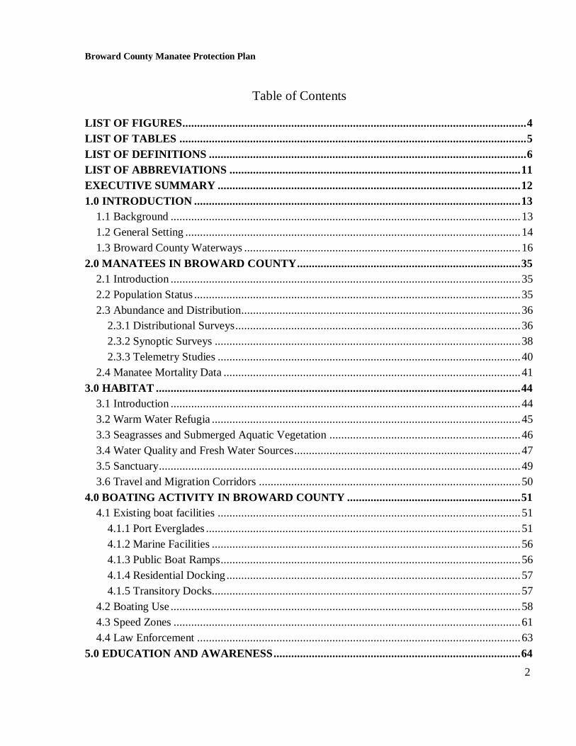
Table of Contents
LIST OF FIGURES..................................................................................................................... 4
LIST OF TABLES ...................................................................................................................... 5
LIST OF DEFINITIONS ............................................................................................................ 6
LIST OF ABBREVIATIONS ................................................................................................... 11
EXECUTIVE SUMMARY ....................................................................................................... 12
1.0 INTRODUCTION ............................................................................................................... 13
1.1 Background ....................................................................................................................... 13
1.2 General Setting .................................................................................................................. 14
1.3 Broward County Waterways .............................................................................................. 16
2.0 MANATEES IN BROWARD COUNTY ............................................................................ 35
2.1 Introduction ....................................................................................................................... 35
2.2 Population Status ............................................................................................................... 35
2.3 Abundance and Distribution............................................................................................... 36
2.3.1 Distributional Surveys ................................................................................................. 36
2.3.2 Synoptic Surveys ........................................................................................................ 38
2.3.3 Telemetry Studies ....................................................................................................... 40
2.4 Manatee Mortality Data ..................................................................................................... 41
3.0 HABITAT ............................................................................................................................ 44
3.1 Introduction ....................................................................................................................... 44
3.2 Warm Water Refugia ......................................................................................................... 45
3.3 Seagrasses and Submerged Aquatic Vegetation ................................................................. 46
3.4 Water Quality and Fresh Water Sources ............................................................................. 47
3.5 Sanctuary ........................................................................................................................... 49
3.6 Travel and Migration Corridors ......................................................................................... 50
4.0 BOATING ACTIVITY IN BROWARD COUNTY ........................................................... 51
4.1 Existing boat facilities ....................................................................................................... 51
4.1.1 Port Everglades ........................................................................................................... 51
4.1.2 Marine Facilities ......................................................................................................... 56
4.1.3 Public Boat Ramps ...................................................................................................... 56
4.1.4 Residential Docking .................................................................................................... 57
4.1.5 Transitory Docks......................................................................................................... 57
4.2 Boating Use ....................................................................................................................... 58
4.3 Speed Zones ...................................................................................................................... 61
4.4 Law Enforcement .............................................................................................................. 63
5.0 EDUCATION AND AWARENESS .................................................................................... 64
Broward County Manatee Protection Plan
3
5.1 Introduction ....................................................................................................................... 64
5.2 Federal Agencies ............................................................................................................... 65
5.3 State Agencies ................................................................................................................... 65
5.4 Nonprofit Organizations .................................................................................................... 66
5.5 Broward County Agencies ................................................................................................. 67
5.6 Private Companies ............................................................................................................. 68
5.7 Signage .............................................................................................................................. 69
6.0 BOAT FACILITY SITING PLAN ..................................................................................... 69
6.1 Introduction ....................................................................................................................... 69
6.2 Data Trend Observations ................................................................................................... 70
6.2.1 Data Collection ........................................................................................................... 71
6.2.2 Data Review ............................................................................................................... 72
6.2.3 Data Analysis .............................................................................................................. 80
6.2.4 Outcomes .................................................................................................................... 89
6.3 Implementation Plan .......................................................................................................... 93
6.3.1 Monitoring .................................................................................................................. 93
6.3.2 Signage ....................................................................................................................... 95
6.3.3 Funding....................................................................................................................... 95
6.3.4 Mitigation/Conservation Measures for Construction.................................................... 96
6.3.5 Law Enforcement Recommendations .......................................................................... 97
6.3.6 Manatee Monitoring Advisory Group.......................................................................... 97
6.3.7 Website ....................................................................................................................... 98
6.3.8 Habitat Impacts ........................................................................................................... 98
6.3.9 Water Quality ............................................................................................................. 98
6.4 Licensing, Permitting, Periodic Plan Review and Revision ................................................ 99
7.0 REVIEWED LITERATURE ............................................................................................ 101
8.0 MANATEE PROTECTION PLAN ORDINANCE ......................................................... 109

Broward County Manatee Protection Plan
4
List of Figures
Figure 1: Attachment K: Manatee Protection Plan Guidelines ……… ......................... 115
Figure 2: Broward County Municipalities ...................................................................... 117
Figure 3: Broward County Waterways ........................................................................... 118
Figure 4: Essential Manatee Habitat Areas..................................................................... 119
Figure 5: Typical Aerial Survey Flight Paths .................................................................. 120
Figure 6: Manatee Distributional Survey ........................................................................ 121
Figure 7: Monthly Average of Manatees Detected on Distributional Surveys ............... 122
Figure 8: Manatee Synoptic Survey ................................................................................. 123
Figure 9: Estimated Manatee Visitation to Two Broward Power Plants ....................... 124
Figure 10: Telemetry Data ............................................................................................... 125
Figure 11: Human Related Manatee Mortality Among 13 Key Counties, 1974-2006 ... 126
Figure 12: Broward County Manatee Mortality (graph) ............................................... 127
Figure 13: Human Related Manatee Mortality Among 13 Key Counties, 1994-2006 ... 128
Figure 14: Broward County Manatee Mortality, Human Related and Perinatal .......... 129
Figure 15: Monthly Watercraft Mortality in Broward County ...................................... 130
Figure 16: Broward County Manatee Mortality (map) .................................................. 131
Figure 17: Broward County Boating Facilities ............................................................... 132
Figure 18: Vessel Registrations and Trends in Broward County ................................... 133
a. Pleasure and Total Vessel Registration
b. Trend of the Percentage of Trailer-able Boats
c. Trend in Pleasure Vessel Registration
Figure 19: Manatee Protection Speed Zones: North Broward County .......................... 134
Figure 20: Manatee Protection Speed Zones: South Broward County .......................... 135
Figure 21: Boating Safety Speed Zones: North Broward County .................................. 136
Figure 22: Boating Safety Speed Zones: South Broward County................................... 137
Figure 23: Law Enforcement Jurisdiction and EMLEG Zones………… ...................... 138
Figure 24: Weekday Boat Survey (Gorzelany 2005) ....................................................... 139
Broward County Manatee Protection Plan
5
Figure 25: Weekend Boat Survey (Gorzelany 2005) ....................................................... 140
Figure 26: Commercial and Single-family Residential Land Use ................................... 141
Figure 27: Vacant Commercial and Single-family Residential Land Use ...................... 142
List of Tables
Table 1: Broward County Marine Facilities, 2006 ........................................................... 143
Table 2: Broward County Boat Ramps, 2006................................................................... 146
Table 3: Broward County Multi-family Facilities, 2006 .................................................. 147
Table 4: Existing and Proposed Dock Density ................................................................. 151
Table 5: Fiscal Year 2001/2002 Registered versus Observed Vessels .............................. 152

Broward County Manatee Protection Plan
6
List of Definitions
1:100 – ratio between boat slip count and shoreline length. This ratio represents typical single-
family density, or one slip for every one hundred feet of shoreline owned or controlled by the
applicant. This ratio is frequently applied to permitting of dock construction by the State of
Florida in key counties without a Manatee Protection Plan.
Anchorage – in-water vessel storage activity either by anchor or fixed mooring device without an
associated dock or physical boat slip. (Source: Sarasota MPP, Sept. 2003)
Application Fee – the non-refundable, partial payment of the new slip fee which is due at time of
application for an Environmental Resource License to construct, reconfigure, or modify the
number of existing slips at a marine facility if the post-construction number of slips will be greater
than five.
Area of Special Concern – areas of particular importance to manatees, including those areas with
documented high use, high death, or represents an important travel corridor between warm water
refuges. These areas are depicted in Figure 3, and are known as Port Everglades, South Fork New
River, Dania Cutoff Canal Middle/C-10, and Dania Cutoff Canal West.
As-built drawing – post construction drawings which document how the facility was built in
relation to the license and must be signed and sealed by a professional engineer or professional
land surveyor registered in the State of Florida.
Boat – a watercraft propelled by sails or one or more electric or internal combustion engine(s). A
boat may refer to any size vessel ranging from a personal watercraft to freighters or cruise ships.
A boat shall not be considered a recreational vehicle even though it has facilities for temporary
living quarters. For purposes of this plan, the word “boat” does not include canoes or kayaks.
(Source: Sarasota MPP)
Boat or Marine Facility – a public or private structure or operation where boats are moored
and/or launched, including commercial, recreational, private, governmental, residential marinas,
and boat ramps. A dry storage facility is considered a boat facility if the dry storage facility has
the capability of launching vessels into adjacent waters or water access is provided adjacent to the
project. Facilities such as long-term boat storage lots, boat yards, or boat dealership lots that do
not have direct water access will not be considered boat facilities. For the purposes of this plan,
coastal waterfront single-family residence and coastal waterfront multi-slip facilities with less
than five (5) slips are not considered a marine facility.
Boat/Manatee Overlap – the use of a particular waterway by both manatees and boats. The
amount of overlap refers to the probability or likelihood of adverse boat and manatee interactions
(such as collisions, crushing, injury or harassment) in a waterway, as a result of boat and manatee
use of the same waterways. (Source: FWC)

Broward County Manatee Protection Plan
7
Boat Ramp – a fixed, structural, man-made or altered natural feature that facilitates the launching
and landing of boats from land into a water body. (Source: FWC)
Class III Waters – those surface waters of the State of Florida that have been classified as
recreation, propagation, and maintenance of a healthy well-balanced population of fish and
wildlife. (Source: Broward County 1997 Comprehensive Plan and FWC)
Coastal Waters – portion of Broward County‟s tidally influenced waterways which have
navigable access to oceanic waters and which lie east of the salinity control structures.
Commercial Marina – a boat facility constructed and used for the purpose of sale, lease, or rent
of boat dockage (dry storage or wet slips) for profit. This type of marina may be owned by private
or governmental entities. (Source: Broward County 1997 Comprehensive Plan and FWC)
Critical Habitats – any federally designated areas which, pursuant to the Endangered Species Act
of 1973, have been determined by the federal government to include physical and/or biological
features that are essential to the survival of an endangered species (such as the manatee), which
may require special management considerations or protection. (Source: Broward County 1997
Comprehensive Plan and FWC)
Dock – a facility, such as, but not limited to, piers, walkways or other structures, that are
constructed within a waterward area and is for the purpose of mooring a vessel. (Chapter 27,
Article XI, Section 27-332)
Dry Storage Facility – an upland structure, upland parking or space used for storing watercraft. A
dry storage facility is considered a boat facility if the dry storage facility has an associated
capability of launching vessels into water, even if that launching point is offsite. Facilities that do
not represent daily in/out facilities, however, such as boat storage for boat dealerships or long-
term, non-use storage (at least six months), are not considered to contribute significantly to boat
traffic and therefore are not subject to the Manatee Protection Plan. (Source: Sarasota MPP and
FWC)
Environmental Resource License (ERL) – an approval issued by EPGMD for activities
involving dredging and filling an aquatic resource, wetland alteration, mangrove alteration or
mitigation banking.
Essential Habitat – any land or water area constituting elements necessary to the survival and
recovery of the manatee population from endangered status, which may require special
management considerations and protective measures. The constituent elements include, but are
not limited to: space for individual and population growth and for normal behavior; available food
sources with adequate water depth and quality; warm and fresh water sources; sites for breeding
and rearing of offspring; and habitats protected from disturbances that are representative of the
geographical and seasonal distribution of the species. Essential Habitat is a criterion for

Broward County Manatee Protection Plan
8
determining areas where marine-related facilities should be limited. (Source: Broward County
1997 Comprehensive Plan)
Existing Boat/Marine Facility – a boat facility that is permitted and/or authorized, or legally in
operation as of the effective date of this plan. Only property owned or controlled by the facility
and licensed or developed as of the effective date of this plan will be considered “existing”.
Good Faith Application – When an Environmental Resource License application has reached a
point in the process wherein County staff has determined that the applicant has provided sufficient
proof of ownership in addition to satisfactorily providing any water quality analysis, sediment and
soil analysis, natural resource survey to accurately characterize the project site conditions, and
appropriate application fee has been paid.
Idle Speed Zone – a speed-regulated area in which vessels create no wake and are not permitted
to proceed at a speed greater than that necessary to maintain steerageway of the vessel. [While
operating in an idle speed zone, all vessel operators shall exercise a high degree of care for
manatee presence.] (Source: FWC)
Linear Shoreline – the mean high water line in tidally influenced areas and the ordinary high
water line along waterways that are not tidally influenced. This definition shall not apply to
shorelines artificially created through dredge and fill activities (such as boat basins or canals) after
the effective date of the plan. Such artificially created shorelines must have received all the proper
permitting authorization required at that time. Shoreline along man-made ditches (such as
mosquito control, flood control ditches, etc.) shall not qualify as linear shoreline, regardless of
their date of construction unless there is documentation of regular navigation use existing prior to
July 1, 2004. Linear shoreline shall be calculated (with a precision of at least to the hundreds of
feet) using survey quality aerial photographs or by accurate field survey. The calculation of linear
shoreline is based upon shoreline that is owned or legally controlled by the applicant. (Source:
FWC)
Long Term Boat Storage Facility – facility that only provides storage for vessels that will not be
used for long periods of time (at least six months). Boats are typically stored in these facilities
seasonally and are not used when they are in storage. The vessels are typically “winterized” and
are moved to other facilities when brought out of storage to be used. These facilities were not
counted in this plan. (Source: FWC)
Manatee Mitigation Fee - the annual fee required from all facilities with five or more slips. A
Marine Facility Operating License will be issued upon payment of this fee.
Mega-Yacht – any motor vessel greater than eighty (80) feet in length.
Mooring – a location where one vessel is typically stored or accommodated when not in use.
Types of moorings include anchorages, beached or blocked, dry stack, hoist, ramp, seawall,
trailer, floating platforms, davits, boat lifts, or wet slip. (Source: Sarasota MPP)

Broward County Manatee Protection Plan
9
Multi-family Residence – a building having a roof and outer walls not entirely separated from
any other structure by space, and occupied by multiple families on a single lot.
Multi-slip Docking Facility – any dock which includes more than one boat slip.
New Slip Fee – the payment required for each new proposed slip above the historical number of
slips at a marine facility.
Permanent Use – commercial, residential or private boat facilities that include wet or dry slips,
moorings or spaces for the storage of vessels. (Source: FWC)
Port Uses – freight terminals or berthing for large vessels (>100‟), including ancillary vessels
required for Port operations. (Source: FWC)
Powerboat – a vehicle designed for operation as a watercraft propelled primarily by motor, (one
or more electric or internal combustion engine(s)). Vessels that have two main propulsion systems
(power and sail) shall be defined as powerboats. (Source: FWC)
Refuge – a manatee protection area in which the U.S. Fish and Wildlife Service has determined
that certain waterborne activities would result in the taking of one or more manatees, and that
certain waterborne activities must be restricted to prevent the taking of one or more manatees,
including but not limited to taking by harassment. (Source: Broward County 1997 Comprehensive
Plan and FWS)
Residential Docking Facilities – docks and wet slips provided for the sole use of the residents of
a residential land use/development adjacent to a coastal water body. These facilities may be for
single-family or multi-family use. (Source: Broward County 1997 Comprehensive Plan)
Roll-On/Roll-Off (Ro/Ro) – containers and cargo rolled or driven on and off transport ships.
(Source: Broward County 1997 Comprehensive Plan)
Sanctuary – a manatee protection area in which the U.S. Fish and Wildlife Service has
determined that any waterborne activity would result in the taking of one or more manatees,
including but not limited to taking by harassment. Sanctuaries are areas reserved exclusively for
manatees, where they may conduct activities such as breeding, nursing, and resting, free from any
harassment by humans. (Source: Broward County 1997 Comprehensive Plan and FWS)
Single-family Dock – a fixed or floating structure, including moorings, used for berthing buoyant
vessels, accessory to a detached single-family residence. (Sarasota MPP)
Single-family Residence – a building having a roof and outer walls entirely separated from any
other structure by space, and occupied by members of a single-family on a single lot. (Source:
Broward County 1997 Comprehensive Plan and FWC)

Broward County Manatee Protection Plan
10
Slip – a space designed for the mooring or storage of a single watercraft, which includes wet or
dry slips, anchorage, beached or blocked, hoist, seawall, floating platforms, davits, boat lifts, or
the number of parking spaces for boat ramps. Piers authorized only for fishing or observation are
not considered wet slips. (Source: FWC)
Slow Speed Zone – a speed regulated area in which vessels are settled in the water, not plowing,
with minimum wake. Slow speed also means no speed greater than that which is reasonable and
prudent to avoid either intentionally or negligently annoying, molesting, harassing, disturbing,
colliding with, injuring, or harming manatees. (Source: FWC)
Submerged Aquatic Vegetation (SAV) – fresh, brackish or saltwater (seagrass) submerged
vegetation that may be used by manatees for food. (Source: FWC)
Transitory Uses – boat facilities with docking for temporary uses (generally less than one day),
including water-dependent public transportation, boat rental, restaurant and hotel docks.
Travel Corridor – a waterway through which manatees travel, either daily or seasonally, in order
to reach feeding areas, sources of fresh or warm water, or other Essential Habitat areas. (Source:
Broward County 1997 Comprehensive Plan and FWC)
Warm Water Refuge – a natural or man-made warm water habitat, which maintains a
temperature equal to or greater than the minimum for manatees‟ survival (approximately 20o
C or
68 o F). (Source: Broward County 1997 Comprehensive Plan)
Broward County Manatee Protection Plan
11
List of Abbreviations
ACOE U.S. Army Corps of Engineers
ASC Area of Special Concern
BOCC Broward County Board of County Commissioners
BFSP Boat Facility Siting Plan
DCA Florida Department of Community Affairs
EMLEG Enhanced Marine Law Enforcement Grant
EPGMD Broward County Environmental Protection and Growth Management
Department (formerly EPD)
ERL Environmental Resource License
ERP Environmental Resource Permit
FAC Florida Administrative Code
FDEP Florida Department of Environmental Protection
FDHSMV Florida Department of Highway Safety and Motor Vehicles
FIND Florida Inland Navigation District
FPL Florida Power and Light Company
FWC Florida Fish and Wildlife Conservation Commission
FWRI Florida Fish and Wildlife Research Institute
FWS U.S. Fish and Wildlife Service
GIS Geographic Information System
ICW Atlantic Intracoastal Waterway
MAC Broward County Marine Advisory Committee
MIASF Marine Industries Association of South Florida
MPP Manatee Protection Plan
NOAA National Oceanic and Atmospheric Administration
PJA Port Everglades Jurisdictional Area
USCG U.S. Coast Guard

Broward County Manatee Protection Plan
12
Executive Summary
This Manatee Protection Plan (MPP) was prepared to meet the requirements of Section
370.12(2)(t), Florida Statutes, which requires the counties identified in the Governor and
Cabinet‟s October 1989 Policy Directive (Broward County was one of the counties identified) to
develop Manatee Protection Plans (MPPs) consistent with Florida Fish & Wildlife Conservation
Commission (FWC) criteria based upon Attachment K of the directive, and to submit such
protection plans for review and approval by the FWC. The statute further requires that each MPP
include a Boat Facility Siting Plan (BFSP). Attachment K states that the objective of a BFSP is to
determine appropriate dock densities for particular areas.
The MPP includes descriptive information and aerial maps of all County waterways accessible to
manatees and describes manatee distribution and abundance as determined by aerial surveys and
telemetry data. State and county manatee mortality data are also presented and were used in
conjunction with boating use data to determine patterns of impact between boats and manatees.
For purposes of the BFSP, the County is divided into three waterway regions: the North, Center,
and South. Based on an analysis of data, the BFSP allows increasing the dock density for each
area. Dock density is calculated by dividing the number of existing docks (i.e., wet slips, dry
slips, boat ramp parking spaces, or transient docks) by the feet of shoreline. The shoreline
measurements are adjusted to exclude shoreline that has little potential for future development,
such as shoreline adjacent to parks, preserves, or roadways. In addition, four “areas of special
concern” are designated based on manatee carcass recovery and waterway usage. Three of these
areas (South Fork New River, Dania Cutoff Canal Middle/C-10 Canal, and Dania Cutoff Canal
West) are assigned specific proposed dock density increases designed to minimize manatee
impacts.
BFSP Zone Existing Docks
Proposed Dock
Increase
North 5,597 1,353
Center 6,381 619
South 10,242 1,033
Port Everglades 2 0
South Fork New River 4,653 471
Dania Cutoff Canal Middle/C-10 3,415 806
Dania Cutoff Canal West 449 110
Total docks 30,739 4,392
These increases in dock density were predicated on the County‟s commitment to implement
additional manatee protection measures including increased law enforcement, monitoring, and
education/awareness. When a County license is issued for slips in a region, the number available

Broward County Manatee Protection Plan
13
for future licensing in that region will be reduced. Similarly, when facilities are closed or
reconfigured to fewer slips, these slips will be added back to the available slip count in that
region. The proposed increase in number of slips in the North and Center waterways exceeds
current and anticipated requests, whereas the proposed number for the South only marginally
surpasses the number of currently requested slips. Demand is expected to be highest in the South
and there has been some concern from local interests that the proposed number may become a
limitation in the future. However, this plan must be reviewed during regular Evaluation and
Appraisal Report (EAR) cycles of the Comprehensive Plan as required by the Department of
Community Affairs (DCA). Increases to density could be sought upon re-evaluation of the plan at
that time or intermittently if supported by new data or information.
To further reduce impacts to manatees, the BFSP proposes additional monitoring, education, and
protection efforts that are to be funded by a combination of new-slip fees at the time of licensing
for marine facility expansions and an annual manatee mitigation fee on slips regulated by this
plan.
1.0 Introduction
1.1 Background
Protection of manatees in Florida began in 1893 with State legislation prohibiting the hunting and
killing of manatees. Florida is one of the fastest growing states in the nation. The human
population has grown from 6.8 million in 1970 to 15.7 million residents in 2000, and is expected
to exceed 18 million by 2010 and 20 million by 2015 (U.S. Census Bureau 2000). This increase
has created a conflict of use between growing human related pressures and limited availability of
coastal resources. Along with population increases, there will be an increase in boat traffic as
coastal areas become increasingly crowded, although data in Broward County comparing growth
of boating with population increases shows minimal boater growth (6%) in spite of large
population increases (20%) from 1995 to 2000. The cumulative effects from both natural and
human related mortalities, combined with habitat loss and low reproductive rate, continue to
jeopardize the long-term existence of the Florida manatee subspecies of the West Indian manatee.
Because of increased incidental manatee mortalities, Florida manatees are now protected by
several forms of legislation, including the Marine Mammal Protection Act of 1972 (amended in
1996), the Endangered Species Act of 1973, and the Florida Manatee Sanctuary Act of 1978. As
a result of concerns over the long term sustainability of the species, the U.S. Fish and Wildlife
Service developed a Manatee Recovery Plan in 1989. The objectives of the Manatee Recovery
Plan are to downlist and ultimately delist the Florida manatee from its State threatened and
Federal endangered status. This plan was revised in 1996 and again in 2001 (FWS 1996, 2001).
In conjunction with the Manatee Recovery Plan, the State of Florida identified 13 “key counties”
with significant manatee populations (Brevard, Broward, Citrus, Collier, Duval, Indian River,
Lee, Martin, Miami-Dade, Palm Beach, Sarasota, St. Lucie, and Volusia). The Florida Governor
and Cabinet directed these counties to develop a comprehensive Manatee Protection Plan (MPP)
in order to minimize human-related threats to the species. The Florida Fish and Wildlife

Broward County Manatee Protection Plan
14
Conservation Commission (FWC) produced a document entitled “Recommendations to Improve
Boating Safety and Manatee Protection for Florida Waterways” which was presented to the
Governor and Cabinet on October 24, 1989. A portion of that document, known as “Attachment
K”, lists the following necessary components that should be included in each county‟s Manatee
Protection Plan (Figure 1):
location and capacity of all marine facilities (including dry storage) in the
county (proposed and existing);
location of all boat ramps in the county (proposed and existing);
boating activity patterns, including travel routes and major destination areas;
manatee sighting information for the county;
manatee mortality information for the county;
any aquatic preserves, Outstanding Florida Waters or other refuge/reserve
information;
port facility information;
location of significant habitat resources, such as seagrass beds, warm water
discharges and fresh water sources;
location of manatee protection and boating safety speed zones in the county
(proposed and existing);
location of manatee information displays;
other relevant data as determined by the FWC.
The effective date of Broward County‟s Manatee Protection Plan (MPP) is the date of a FWC
approval letter. The plan is submitted to FWC seeking this approval following the approval by the
Broward County Board of County Commissioners. Subsequently, the approved plan is forwarded
to the Department of Community Affairs (DCA) to initiate incorporating the MPP into the
Manatee Protection Plan in the County‟s comprehensive plan. This and other portions of the
Manatee Protection Plan may be updated as required with the necessary approvals.
1.2 General Setting
Located in South Florida‟s Gold Coast region with the Atlantic Ocean to the east, Broward
County (2000 population: 1.6 million) lies between Palm Beach County to the north and Miami-
Dade County to the south. Hendry and Collier counties are to the west and encompass 1,197
square miles. The western portion of Broward County contains 787 square miles (two-thirds of the
entire area) consisting of water conservation areas and parts of both the Miccosukee Indian
Reservation (reaching into Miami-Dade) and the Big Cypress Seminole Indian Reservation
(extending into Hendry County). The 410 square miles of developed area to the east includes the
City of Fort Lauderdale, not only the county seat, but also the most populous of Broward‟s 32
municipalities (Figure 2) and a popular tourist destination. The aesthetic and economic importance
of Fort Lauderdale‟s New River and Atlantic Intracoastal Waterway (ICW) System is evidenced
by the city‟s distinction as both the “Venice of America” and the “Yachting Capital of the World.”

Broward County Manatee Protection Plan
15
Broward County‟s tidal waterways are unique compared to other Florida counties. Characterized
as predominantly linear, the marine waterways rarely exceed 1000 feet in width and most
shorelines are stabilized with a seawall, riprap, or other erosion control system. Broward is also
home to one of the nation‟s busiest ports located at one of three inlets (although, Boca Raton Inlet
is located in Palm Beach County) serving County boaters.
Trends in Broward County development show a conversion of waterfront property from
commercial to residential land use. Examples of this trend are reflected on the New River in Fort
Lauderdale where existing marine facilities are converting to high density multi-family
residential. Other facilities adjacent to the ICW near the Stranahan River have reconfigured
existing docks to accommodate larger vessels, often by reducing the number of slips at a site. New
development located adjacent to the C-10 canal includes a dry stack facility, but the Dania Cutoff
Canal is experiencing the development of residences and associated dockage. Although changes to
these areas reflect the recent increased demand for residential and mega-yacht dockage, other
areas of the County, such as the South Fork New River, have changed little from the existing use
where a significant number of service and storage facilities remain.
Rising human-related pressures and increasingly limited coastal resources increasingly conflict.
As population increases, there may also be an increase in boat traffic, although it is unclear if a
saturation level will be reached. The adverse impact of watercraft on manatees is well
documented. Reynolds and Gluckman (1988) demonstrated that the vast majority of adult
manatees throughout Florida have scars that are representative of either single or repeated
collisions with watercraft. In addition, a correlation between the number of registered vessels in
Florida and the number of watercraft-related manatee mortalities has been shown to be
statistically significant (Wright et al. 1995). However, a statistically significant trend of manatee
mortality is lacking in Broward County due to the relatively small data set from the past 12 years
(see following table). Therefore, Broward County lacks a consistent number of watercraft related
manatee mortalities to make a statistical projection of future mortality trends. However, spatial
locations of mortalities show groupings where further enforcement and education may be directed.
Watercraft-Related Manatee Mortalities 1994-2006
Mean 2.5
Median 2
Standard Deviation 1.8
Minimum 0
Maximum 5
Sum 33
This document presents the background information and an inventory of existing conditions
needed for the preparation of a Boat Facility Siting Plan (BFSP), one of three parts of the Broward
County Manatee Protection Plan (MPP). A MPP is a state- and county-approved summary of
manatee data, strategies, and management actions aimed at protecting manatees in a specific area
or county, including the 13 “key” counties described previously in this document. Such a plan

Broward County Manatee Protection Plan
16
consists of the following three components: Boating Safety, Education and Awareness, and Boat
Facility Siting. Manatee Protection Plans are important for the long-range planning needed to
ensure the survival of the endangered manatee in the rapidly growing State of Florida. The BFSP
component provides countywide guidance for future expansion of boat facilities. Such a plan
specifies the appropriateness of locations for boating-related facility development based upon an
evaluation of manatee protection needs and subsequent minimization of boater/manatee overlap.
1.3 Broward County Waterways
To protect manatees and their habitats, a review of county waterways is essential. Most of the
over 220 miles of waterways with ocean access in Broward are man-made canals or channelized
rivers with the exceptions being remnants of a few historically freshwater rivers such as Cypress
Creek, Middle, and New Rivers. The basic canal network construction throughout the County
began in the early 1900s for drainage and flood control to facilitate land development. Water
control structures were authorized by Congress in 1948 as part of the Central and Southern Florida
Project for purposes including flood control and prevention of saltwater intrusion. These
structures compose the westernmost extent of brackish (a mixture of salt and fresh water) surface
waters and the inland extent of waterways addressed by this MPP. Today, seven primary canals
and numerous secondary and tertiary canals provide water-supply and flood protection.
Based on locations of the region‟s three inlets, three waterways were identified as primary travel
corridors for boaters in Broward County: North, Center, and South Waterways. These and other
referenced Broward County waterways are shown in Figure 3. These corridors also represent the
source for boater/manatee overlap. Access is gained through the Hillsboro and Port Everglades
inlets along the Atlantic Ocean and from adjacent counties via the ICW. In 1993, State manatee
protection speed zones were adopted county-wide throughout tidally influenced waterways, and
by 1994, signs posting these zones were installed (Comp. Plan, Vol. 4 Support Documents, p. 13-
92).
Hillsboro Canal
The Hillsboro Canal represents the northern jurisdictional boundary shared with Palm Beach
County. From the west, the Hillsboro Canal, starts with the salinity control structure, G56, located
approximately 1000 feet west of Military Trail. The canal takes a turn to the south meeting Dixie
Highway, then back to the north at Federal Highway before heading southeast, connecting to the
ICW. This area is composed of about 8 miles of shoreline excluding the Palm Beach side of
Hillsboro Canal. The Canal width ranges from less than 90 feet to more than 180 feet.

Broward County Manatee Protection Plan
17
More than 4500 feet of the Hillsboro Canal shoreline is composed of Deerfield Island Park, a
County managed park owned by the Florida Inland Navigation District. In addition, Pioneer Park,
with a boat ramp and 12 trailer parking spaces, is located less than 500 feet east of Dixie
Highway. Furthermore, three marinas are located along this waterway with a capacity to hold
about 981 vessels.
Residential use makes up for the majority of the canal shoreline. Single-family homes make up
more than two miles of shoreline, while multi-family homes, including condos, compose about a
mile of shoreline. Two trailer parks exist near the western extent of the waterway with significant
dock capacity.
Institutional Limitations
The Hillsboro Canal is regulated by two manatee protection speed zones. A “50-foot slow speed
buffer”, a zone restricting vessels to slow speed within 50 feet from the shoreline, extends from
the salinity control structure to Deerfield Island Park. A “slow speed” manatee protection zone
extends from the westernmost portion of Deerfield Island Park to the southeast, including about
1000 feet south from the confluence with the ICW, overlapping a boating safety speed zone “slow
speed, no wake”.

Broward County Manatee Protection Plan
18
Hillsboro River
Beginning at the northern shoreline of
Deerfield Island Park, the Hillsboro River
travels south along the ICW from the
Palm Beach County line towards the
Hillsboro Inlet, ending approximately
1000 feet north of Sample Road. Fifteen
secondary canals extend between 600 and
4500 feet in length to the west terminate
before reaching Federal Highway. These
canals connect predominantly residential
land uses, with a potential for over 1300
single-family docks, with the ICW.
A marina and a yacht club exist in this
area with a combined capacity less than
90 boat slips. In addition to Deerfield
Island Park, this section of waterway also
borders Sullivan Park and Peg DeGroff
Park, all lacking docks and ramps. Multi-
family and single-family residential make
up the major source of boats for this area.
Institutional Limitations
Hillsboro River is regulated by both
manatee protection and boating safety
speed zones. Except for approximately
1000 feet at the Hillsboro Canal, this area
is designated as a manatee protection
“slow speed zone on the weekends from
November 15-March 31, and 25 mph with
a 50-ft slow speed buffer for the
remainder of the year”. The area at the
Hillsboro Canal is “slow speed” year
round. The boating safety “slow speed, no
wake” zone extends from approximately
NE 2nd
Street to SE 4th Street, from north
of the mouth of the Hillsboro Canal
extending south about 300 yards.
Hillsboro Inlet
Spanning less than 1.5 miles both north and south of the Hillsboro Inlet, this area includes
waterways from beyond Sample Road in the north to Atlantic Boulevard in the south. This inlet
lies about six miles south of the Boca Raton Inlet, and about twelve miles north of the Port

Broward County Manatee Protection Plan
19
Everglades Inlet less than 4.5 miles south of the Palm Beach County line. Like the Hillsboro River
portion, this inlet area hosts several finger-lakes or canals extending between 600 and 4000 feet
inland.
This area includes three marinas with
a capacity for 388 vessels and a
public boat ramp at Alsdorf Park
containing 80 trailer spaces. Other
parks adjacent to the waterway
include Fletcher Park, Exchange
Club Park, Sunset Park and Harbors
Edge Park.
Institutional Limitations
This area is regulated by manatee
protection and boating safety speed
zones. For manatee protection, the
area including a mile north and south
of the inlet is zoned for “slow speed
Nov. 15 – Mar. 31, with a 25 mph,
50ft slow speed buffer during the
remainder of the year.” Beyond that
point in both directions, the
regulation is “slow speed weekends
Nov. 15 – Mar. 31: 25 mph with 50ft
slow speed buffer remainder of
year.” This waterway is also
regulated by four boating safety
speed zones. The inlet is regulated as
a “slow speed, minimum wake”
zone. An “idle speed, no wake”
zone exists on the ICW from the
northern boundary of the waterway
to about 900 feet south of the inlet.
Then, a “slow speed, minimum
wake” zone immediately follows for
about 4500 feet to an “idle speed,
minimum wake” zone that runs
about 1500ft., to Sunset Park.
Cypress Creek Area

Broward County Manatee Protection Plan
20
The Cypress Creek Area waterway includes Cypress Creek and the Pompano Canal. This
waterway is characterized mainly as a series of smaller, residential finger canals off of two main
branches converging on approach to the ICW. The area is confined within the following
boundaries: Atlantic Avenue to the north, Commercial Boulevard to the south, Dixie Highway to
the west and Federal Highway to the east. The majority of the shoreline is developed as
residential with over
2000 parcels
adjacent to the
water.
Two salinity control
structures restrict
boating access
upstream. On the
Cypress Creek
Canal, S37A is
located about 250
feet east of Dixie
Highway and on the
Pompano Canal,
G57 is located at the
southeast quadrant
of the intersection
of Atlantic Avenue
and Cypress Road.
This waterway lacks
access through
public parks, but
two marinas exist
with a 196
combined boat
storage capacity.
Institutional
Limitations
The manatee protection speed zone is regulated as a “slow speed” zone from the salinity control
structures east to Federal Highway. This area lacks boating safety speed zone restrictions.
Broward County Manatee Protection Plan
21
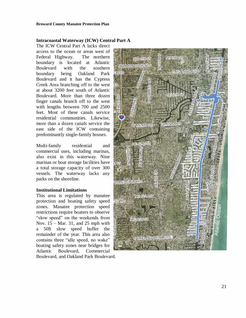
Intracoastal Waterway (ICW) Central Part A
The ICW Central Part A lacks direct
access to the ocean or areas west of
Federal Highway. The northern
boundary is located at Atlantic
Boulevard with the southern
boundary being Oakland Park
Boulevard and it has the Cypress
Creek Area branching off to the west
at about 3200 feet south of Atlantic
Boulevard. More than three dozen
finger canals branch off to the west
with lengths between 700 and 2500
feet. Most of these canals service
residential communities. Likewise,
more than a dozen canals service the
east side of the ICW containing
predominantly single-family houses.
Multi-family residential and
commercial uses, including marinas,
also exist in this waterway. Nine
marinas or boat storage facilities have
a total storage capacity of over 300
vessels. The waterway lacks any
parks on the shoreline.
Institutional Limitations
This area is regulated by manatee
protection and boating safety speed
zones. Manatee protection speed
restrictions require boaters to observe
“slow speed” on the weekends from
Nov. 15 – Mar. 31, and 25 mph with
a 50ft slow speed buffer the
remainder of the year. This area also
contains three “idle speed, no wake”
boating safety zones near bridges for
Atlantic Boulevard, Commercial
Boulevard, and Oakland Park Boulevard.
Broward County Manatee Protection Plan
22
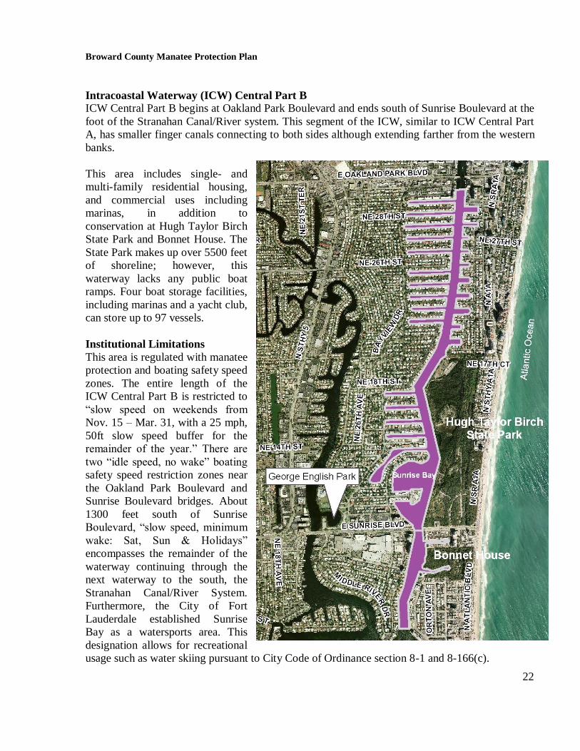
Intracoastal Waterway (ICW) Central Part B
ICW Central Part B begins at Oakland Park Boulevard and ends south of Sunrise Boulevard at the
foot of the Stranahan Canal/River system. This segment of the ICW, similar to ICW Central Part
A, has smaller finger canals connecting to both sides although extending farther from the western
banks.
This area includes single- and
multi-family residential housing,
and commercial uses including
marinas, in addition to
conservation at Hugh Taylor Birch
State Park and Bonnet House. The
State Park makes up over 5500 feet
of shoreline; however, this
waterway lacks any public boat
ramps. Four boat storage facilities,
including marinas and a yacht club,
can store up to 97 vessels.
Institutional Limitations
This area is regulated with manatee
protection and boating safety speed
zones. The entire length of the
ICW Central Part B is restricted to
“slow speed on weekends from
Nov. 15 – Mar. 31, with a 25 mph,
50ft slow speed buffer for the
remainder of the year.” There are
two “idle speed, no wake” boating
safety speed restriction zones near
the Oakland Park Boulevard and
Sunrise Boulevard bridges. About
1300 feet south of Sunrise
Boulevard, “slow speed, minimum
wake: Sat, Sun & Holidays”
encompasses the remainder of the
waterway continuing through the
next waterway to the south, the
Stranahan Canal/River System.
Furthermore, the City of Fort
Lauderdale established Sunrise
Bay as a watersports area. This
designation allows for recreational
usage such as water skiing pursuant to City Code of Ordinance section 8-1 and 8-166(c).

Broward County Manatee Protection Plan
23
Middle River Area
The Middle River Area begins from the west at the salinity control structure S36 and dissects to
the North and South Fork east of I-95 then converges 2 miles before reaching the ICW.
Residential land use dominates the shoreline with more than 1300 units. Two commercial boat
facilities provide space for 5 boats. Three boat ramps at public parks, including George English
Park, provide 77 trailer parking spaces. Park land shoreline on this waterway exceeds 6300 feet
and includes Mills Pond Park, Colohatchee Park, and George English Park.
Institutional Limitations
A “slow speed” manatee protection speed zone exists from S36 to the eastern convergence of the
North and South Fork. This waterway lacks any boating safety speed restriction zones.
Furthermore, the City of Fort Lauderdale established 5000 feet of the Middle River, north from
George English Park, as a watersports area. This designation allows for recreational usage such as
water skiing pursuant to City Code of Ordinance section 8-1 and 8-166(c).
North Fork New River
From the west, the salinity control structure, S33, initiates the North Fork New River waterway.
The North Fork continues in a southeast direction under I-95 and Broward Boulevard to meet its
terminus at the South Fork New River.

Broward County Manatee Protection Plan
24
From the S33 to Broward Boulevard the majority of the land use is single-family residential with
small, but significant shorelines of commercial (more than 1700 feet), namely the Swap Shop, and
more than 2500 feet along parks, specifically the Reverend Samuel Delevoe Park. Between
Broward Boulevard and the North Fork‟s terminus at the South Fork, the land use is composed of
single- and multi-family residences and commercial businesses.
This waterway includes one commercial boat storage facility with a capacity of 5 boats, but lacks
public boat ramps.
Institutional Limitations
A “slow speed” manatee protection speed zone exists throughout the waterway; however, it lacks
any boating safety speed restriction zones.
New River Junction
The New River Junction connects the North and South Forks of the New River to the ICW,
passing through downtown Fort Lauderdale. This system also includes the Tarpon River tying
into the south side of the western and eastern extents. Additionally, the Himmarshee Canal spurs
to the north 1300 feet west of the eastern boundary of this system.
The New River Junction includes many recreational, commercial, and residential uses. More than
7700 feet of shoreline close to downtown is utilized as the Fort Lauderdale Riverwalk including

Broward County Manatee Protection Plan
25
the Performing Arts Center, Discovery Park, and DDA Plaza. Colee Hammock Park is located
near the ICW on the New River while Tarpon Cove Park and Himmarshee Park are located on the
Tarpon River and Himmarshee Canals, respectively. Six boat storage facilities, including
Cooley„s Landing, lend to a total capacity of 483 vessels. In addition, Cooley‟s Landing includes
three boat ramps servicing 22 trailer parking spaces. Nearly 280 vessels may be attributed to
single and multi-family residential uses.
Institutional Limitations
The New River Junction lacks boating safety speed restriction zones; however, a manatee
protection “slow speed” zone encompasses both the New River and Tarpon River.
South Fork New River
The South Fork New River includes the North New River Canal west to the salinity control
structure G54, and South New River Canal to Dania Cutoff Canal. Additionally, this waterway
links the ICW via the New River Junction and Stranahan River to the Lauderdale Power Plant, a
significant destination for manatees during winter months. This waterway usually contains on
average three manatees as sited during the bimonthly monitoring. During the winter months of
2005, two-thirds of the sited manatees were seen in transit towards the Lauderdale Power Plant. In
the past two years, manatee counts during the winter months, typically the highest of the year, are
more than 110. This waterway is an area of special concern.

Broward County Manatee Protection Plan
26
This waterway is designated an „area of special concern‟ due to the high probability of
boater/manatee overlap. This area includes the second highest number of manatee carcass
recoveries in the County. Since 1977, 24 carcasses were reported including six attributed as
human related. In contrast, 75% of the carcasses recovered in Port Everglades were caused by
human interaction within that period.
Survey records show eight perinatal carcass recoveries in this waterway since 1986. Five of the
eight perinatal carcasses have been reported since 1989 in the westernmost extent of this
waterway, north of the New River Canal, adjacent to single-family land use,
This waterway has the highest capacity for commercial and potential residential vessel storage in
the County. Seventeen boat storage facilities have a capacity totaling 1829 vessels. Single-family
and multi-family residential uses may account for an additional 2700 vessels. One new boat ramp
is located in this waterway east of State Road 7/US 441 with a capacity of 9 trailer parking spaces.

Broward County Manatee Protection Plan
27
More than 2 miles of shoreline is managed for preservation including cypress and mangrove
wetlands located in Pond Apple Slough and the Secret Woods Nature Center, inclusively.
Institutional Limitations
The South Fork New River area lacks boating safety speed restriction zones; however, manatee
protection zones exist throughout. A majority of this area is mandated as “slow speed” for
manatee protection with the only exception is within 2400 feet of where the North and South New
River Canals converge on the South Fork New River. This area is regulated as an “idle speed”
zone.
Stranahan River and Canals
The Stranahan River and Canals area links the Port Everglades to the south to the northern
Broward waterways via the ICW. Furthermore, this waterway connects the New River Junction
and Middle River Areas to the ICW. Other features of this area include the numerous finger canals
servicing single- and multi-
family residential uses, the
major land use of this waterway.
The Stranahan River is the name
for the ICW between Las Olas
Boulevard and SE 17th Street.
The majority of vessels
originating from this area
embark from commercial and
private storage. More than 1163
vessels may be stored at the
sixteen commercial boat storage
facilities. Commercial tourist
vessels regularly use this
waterway. This area also
includes the potential for more
than 2500 vessels housed at
single- and multi-family
residential sites. The waterway
includes one boat ramp located
at SE 15th Street with a trailer
parking capacity of 58, although
this quantity is often surpassed.
This area lacks shoreline
managed as natural parks.
Institutional Limitations

Broward County Manatee Protection Plan
28
Three boating safety speed zones and two manatee-related speed zones exist in this waterway. The
boating safety speed zones are limited to the ICW. A “slow speed minimum wake” boating safety
speed zone extends about 3000 feet north and south of the mouth to the New River. Beyond that
location to the south, exists the “idle speed, no wake” zone to SE 17th Street bridge. A separate
“idle speed, no wake” zone also extends north about 4800 feet to a “slow speed minimum wake:
Sat, Sun & holidays” zone that completes the run to the northern edge of the waterway.
From the northern boundary of this waterway to the first bend to the west of the ICW, manatee
related boat speed is regulated to “slow speed weekends Nov 15 – Mar 31: 25mph with 50ft slow
speed buffer remainder of year”. For the remaining portion of the ICW in this waterway including
the portion of the New River and finger canals to the south, the manatee related speed zone is
“slow speed.” Furthermore, the City of Fort Lauderdale established Rio Barcelona Canal, the
mouth of the Middle River, Sylvan Lake, and Mayan Lake as watersports areas. This designation
allows for recreational usage such as water skiing pursuant to City Code of Ordinance section 8-1
and 8-166(c).
Port Everglades
Port Everglades Inlet is a
primary access to the Atlantic
Ocean for the County and
serves cargo and passenger
ships, recreational boaters, and
the occasional navy vessel. This
corridor also is the route for
hundreds of manatees seeking
the warm waters of the Port
Everglades Power Plant effluent
during the winter months.
Facilities exist in the waterway
with a capacity to hold 553
vessels. The marinas include
Nova Southeastern University
and the U.S. Coast Guard, both
located on the west side of the
barrier island across from the
Port Everglades facility. One
boat ramp exists with trailer
parking for 74 vehicles. The
south bank of the Dania Cutoff
Canal is managed as mangrove
habitat in West Lake Park.
Broward County Manatee Protection Plan
29
Potential boater/manatee overlap is reflected in the more than 40 carcass recoveries reported since
1974. Human related activities such as watercraft operation attributed to 30 of those manatee
deaths.
Port Everglades is located about 23 miles north of Port of Miami and about 12 miles south of the
Hillsboro Inlet. The waterway includes the shoreline of the port operations from SE 17th
Street
bridge south to the length of the Dania cutoff canal adjacent to the Port‟s container storage area.
The warm-water refuge areas from the power plant located within this area are designated by
Broward County as Manatee Essential Habitat (1989 Comprehensive Plan Vol. 4, 13A-42).
Broward County‟s Comprehensive Plan prohibits the construction of new marinas or expansion of
existing marinas, docking facilities, and boat ramps, except those related to law enforcement,
within Manatee Essential Habitat Areas (1997 Comprehensive Plan, Policy 13-A.3.1, Ordinance
Number 96-39).
This shoreline includes areas dedicated to natural resource protection such as the County‟s West
Lake Park and John U. Lloyd Stat Park. Additional shoreline comprised of mangroves exists at the
mouth of the power plant‟s effluent canal.
Institutional Limitations
Boating safety and manatee related speed regulations in addition to a Federal security speed zone
exist in this area. The effluent canal originating from the power plant and mangrove area within
the Port are restricted as a “no entry zone.” “Idle speed from Nov. 15 – Mar. 31, and slow speed
the remainder of the year” regulates the length of waterway 2600 feet north and south of the
mouth of this canal on the ICW. Beyond this zone, the ICW and Port area is designated as “slow
speed” zones. The U.S. Department of Homeland Security recently established a “slow speed
zone” within the inlet extending about 1300 feet from the ICW to increase port security.
Dania Cutoff Canal East
The Dania Cutoff Canal East is a linear east-west stretch of the Canal from US 1 east to the
container storage area of Port Everglades.
The Dania Cutoff Canal has been identified in the Broward County Comprehensive Plan as a
primary manatee travel corridor. The canal width ranges between 90 and 190 feet; however, the
area serves seven facilities with a capacity of 741 vessels. This waterway also includes one boat
ramp with a parking capacity of 73 trailers.

Broward County Manatee Protection Plan
30
Institutional Limitations
The waterway lacks boating safety speed restriction zones, however; the entire length is regulated
as “slow speed” for manatee protection.
Dania Cutoff Canal Middle/C-10 Canal
The Dania Cutoff Canal Middle/C-10 Canal is located on the Dania Cutoff Canal between the SW
30th Avenue and US1 and includes the C-10 Canal and C-10 Spur. There are numerous secondary
canals off the Dania Cutoff Canal that provide navigational access to single-family homes, as well
as smaller areas of industrial and commercial land uses. The C-10 Canal connects to the Dania
Cutoff from the south nearly a mile downstream from I-95. The Spur breaks off west from the
Canal a half mile south of Stirling Road and extends west to water control structure CS22.
Industrial and commercial land uses comprise most of the C-10 Canal shoreline north of the Spur
intersection; however, south of that point including the Spur, residential and recreational
opportunities, such as golf courses, predominate.
This area has a high perinatal concentration, with two perinatal mortalities since 1977, and the
Dania Cutoff Canal section is a primary travel corridor for manatees. For these reasons, this zone
is designated an “area of special concern”.
Significant physical barriers for this waterway include the fixed bridges at US1 and the adjacent
FEC railroad that limits vessel vertical clearance.

Broward County Manatee Protection Plan
31
Fifteen boat storage facilities exist
in this zone with a capacity of
2462 vessels, including a new
storage facility recently opened
with a capacity of more than 210
vessels. There are also two boat
ramps with parking for ten trailers
total.
The Dania Cutoff Canal portion
of this zone has a significant
amount of shoreline managed for
natural preservation.
Institutional Limitations
The waterway lacks boating
safety speed restriction zones,
however; the entire length is
regulated as “slow speed” for
manatee protection.
Dania Cutoff Canal West
The Dania Cutoff Canal West
east-west canal located between
the S13 control structure on the
west and SW 30th Avenue. This
waterway terminates at State
Road 7 due to the S13 water
control structure. This terminus is
1780 feet west of the location where the South Fork New River converges with the Canal. There
are numerous secondary canals off the Dania Cutoff Canal that provide navigational access to
single-family homes, as well as smaller areas of industrial and commercial land uses.
Human related activities including watercraft and flood gate operation explained four of fifteen
mortality records. This area has been the location of perinatal mortalities and is also a travel
corridor for manatees and has been designated an “area of special concern”.
Since 1977, mortality surveys include eight perinatal records, which equates to the number of
perinatal deaths reported in the South Fork New River since 1989. Most of the mortalities in this
waterway are reported at the westernmost extent of Dania Cutoff Canal West.

Broward County Manatee Protection Plan
32
Significant physical barriers for this waterway include the fixed bridges at US1 and the adjacent
FEC railroad that limit vessel vertical clearance.
This waterway includes two boat storage facilities storing 45 vessels. This length of the Dania
Cutoff Canal has a significant amount of shoreline managed for natural preservation.
Institutional Limitations
The waterway lacks boating safety speed restriction zones, however; it is regulated as “slow
speed” for manatee protection, with the vicinity of the Lauderdale Power Plant as an exception.
This exception is a mile of the canal including secondary waterways from the South Fork New
River east towards SW 30th
Avenue that is regulated as “idle speed Nov. 15 – Mar. 31” and “slow
speed the rest of the year”.

Broward County Manatee Protection Plan
33
Intracoastal Waterway (ICW) South
The ICW South includes
the ICW and associated
basins plus canals from the
Dania Cutoff Canal south
more than six miles to the
County boundary with
Miami-Dade. This area
includes the gamut of uses
including commercial,
single- and multi-family
residential, marina, and
park and conservation.
Remaining undeveloped
areas are predominately
designated as conservation
or recreation.
Facilities exist in the
waterway with a capacity
to hold 434 vessels. The
marinas include
SeaTech/Seafair and the
Diplomat Hotel on
Hollywood Beach. Two
boat ramps exist with
trailer parking for 93
vehicles. More than three
miles of the ICW west
bank located south of the
Dania Cutoff Canal is
managed as mangrove
habitat in West Lake Park.
Institutional Limitations
This area includes both manatee protection and boating safety speed restrictions. Speed
restrictions include three “idle speed” zones: the Dania Beach Boulevard bridge, south of
Sheridan Street past Hollywood Boulevard, and north of Hallandale Beach Boulevard. There are
also two “slow speed, minimum wake” zones located at Sheridan Street and Hallandale Beach
Boulevard bridges. The manatee protection speed zone is predominantly regulated as “25mph
with a 50ft slow speed buffer” although the speed is regulated as “slow speed” from the Dania
Cutoff Canal extending south for about a mile.

Broward County Manatee Protection Plan
34
Lauderdale Power Plant
The Lauderdale Power Plant is located west of the Fort Lauderdale/Hollywood International
Airport, south of I-595, east of State Road 7 and north of the Dania Cutoff Canal.
This waterway includes a warm-water refuge area resulting from effluent of power generation and
is designated by Broward County as Manatee Essential Habitat (1989 Comprehensive Plan Vol. 4,
13A-42). Broward County‟s Comprehensive Plan prohibits the construction of new marinas,
docking facilities, and boat ramps or expansion of existing marinas, except those related to law
enforcement, within Manatee Essential Habitat Areas (1997 Comprehensive Plan, Policy 13-
A.3.1, Ordinance Number 96-39). The typical winter manatee counts in this area exceed 100
individuals.
The waterway lacks existing boat storage facilities and boat ramps.
Broward County Manatee Protection Plan
35
Institutional Limitations
This area‟s “no entry zone” regulation exceeds the need to designate speed zones.
2.0 Manatees in Broward County
2.1 Introduction
The Florida manatee (Trichechus manatus latirostris) is a distinct subspecies of the West Indian
manatee (Trichechus manatus) and is listed as endangered throughout its range. Manatees (Order
Sirenia) evolved from land mammals more than 60 million years ago and have a fossil record
extending from approximately 45 million years ago. While information on manatees prior to the
first half of the 20th
century is limited, it is known that these marine mammals were hunted in
Florida as early as the Paleo-Indian period (8500-6000 B.C). This time period coincides with the
earliest known occupation of Florida by aboriginal Indians (Reynolds and Odell 1991). Analysis
of historical records suggest the routine hunting of manatees in Florida by both Indians and
settlers in the 1800s (FWS 2005).
Florida represents the northern limit of the typical geographic range of the manatee, though some
individuals have been known to occasionally travel farther north along the eastern seaboard and
west along the Gulf of Mexico states (FWS 2001). They can be found in riverine (fresh), estuarine
(brackish), and coastal (marine) environments in the southeastern United States. These areas
include many habitat types, including vegetated freshwater bottoms, coastal marshes, seagrass
meadows, tidal creeks, and man-made canals. In addition, manatees also utilize natural springs,
artificial warm-water sites such as power plants for warmth, quiet secluded tributaries and creeks
for resting, calving, and nurturing their young, and open waterways and deep channels including
man-made dredged canals as travel corridors (FWS 2001). Figure 4 shows essential manatee
habitats located in Broward County. In summary, while manatees tend to have preferred areas
and aggregation sites, they can be found in a wide variety of coastal habitats.
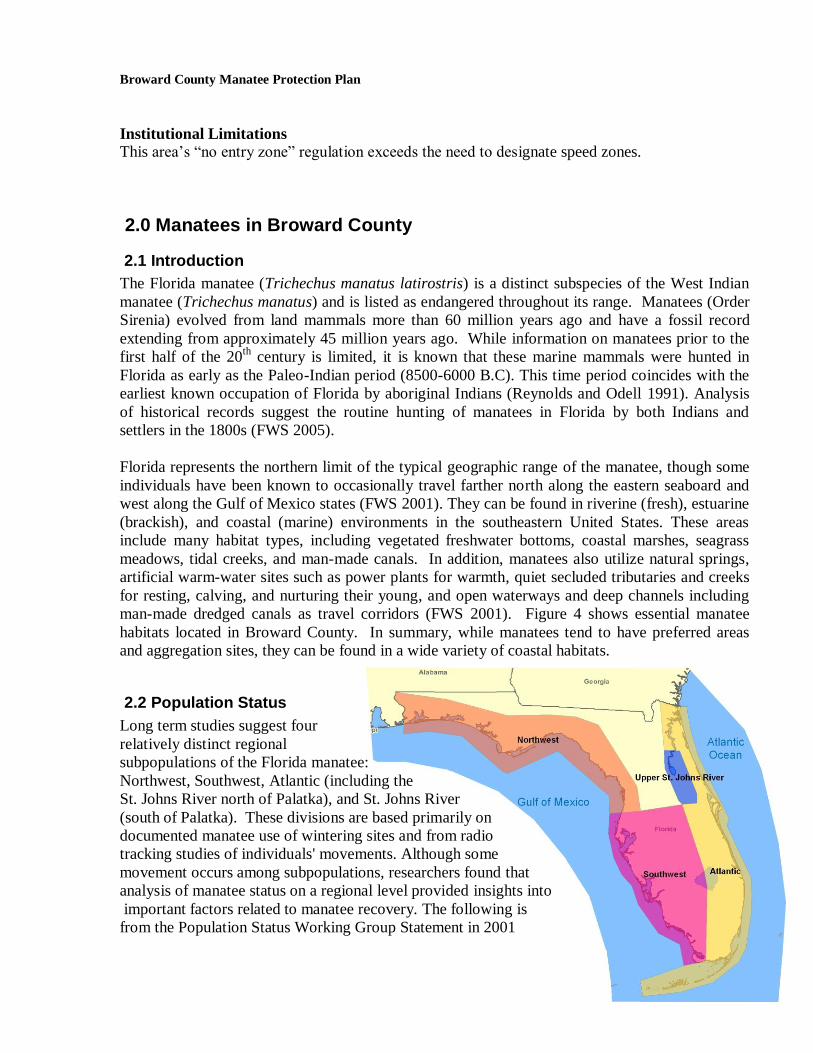
2.2 Population Status
Long term studies suggest four
relatively distinct regional
subpopulations of the Florida manatee:
Northwest, Southwest, Atlantic (including the
St. Johns River north of Palatka), and St. Johns River
(south of Palatka). These divisions are based primarily on
documented manatee use of wintering sites and from radio
tracking studies of individuals' movements. Although some
movement occurs among subpopulations, researchers found that
analysis of manatee status on a regional level provided insights into
important factors related to manatee recovery. The following is
from the Population Status Working Group Statement in 2001

Broward County Manatee Protection Plan
36
(FWS 2001) regarding the Atlantic coast subpopulation:
Scientists are concerned that the adult survival rate (the percentage of adults that survives
from one year to the next) is lower than what is needed for sustained population growth. The
population on this coast appears to have been growing slowly in the 1980s but now may have
leveled off, or could even be declining. In other words, it’s too close to call. This finding is
consistent with the high level of human-related and, in some years, cold-related mortality in
the region…..In order to assure high adult survival the group emphasizes the urgent need to
make significant headway in reducing the number of human-related manatee deaths.
A Biological Status Review of the Florida manatee was finalized in December 2002 by FWC‟s
Florida Wildlife Research Institute (FWRI). This review states that, statewide, the rate of increase
in watercraft-related manatee deaths over the past decade (expressed as annual percentage
increase) exceeds estimates of population growth rate. In addition, it also states that it is likely
that there will be a 50% decline in the Florida manatee population within the next 45 years (FWC
2002).
2.3 Abundance and Distribution
Data on manatees observed in Broward County are available from a variety of sources:
1. distributional survey, Broward County, 1991-1992, 2004- present
2. distributional survey, FWC, 1988-90
3. synoptic survey, FWC, 1991- present,
4. proximity to Broward County power plants, FPL, 1977- present
5. telemetry data, U.S. Geological Survey Sirenia Project, 1986-1998
6. mortality and necropsy data, FWC, 1974- present
These data provide a long term database of information on manatee abundance and trends in
Broward County. The following discussion reviews their pertinence in the process of establishing
appropriate locations for boat facilities.
2.3.1 Distributional Surveys
Low-level aerial surveys are generally accepted as the most effective method for collecting
information on manatee distribution, and are typically used to determine minimum estimates of
the manatee population size (Ackerman 1995). Survey techniques typically follow methods
described by Irvine et al., (1982) and Packard et al., (1989), and involve the flying of a standard
flight path, with repeated circles over areas where manatees are sighted. Surveys typically utilize
a fixed wing aircraft at a speed of approximately 90 knots and at an altitude of 500 feet or a
helicopter at a similar altitude. Survey frequency is usually a function of the level of funding
support, however monthly or twice-monthly surveys are most common.

Broward County Manatee Protection Plan
37
Three aerial survey datasets of Broward County are available for review. The first series of
surveys was conducted by FWC between 1988-1990 (48 flights). The second series of surveys
were conducted by Broward County staff between 1991-1992 (12 flights) and the third a year
round bi-monthly survey initiated in 2004. The Broward surveys include the major tributaries,
such as the New River, while FWC surveys within the County were limited to the ICW and
routinely conducted twice-monthly. The 1991-1992 Broward County surveys essentially focused
on winter months. However, limited surveys were also conducted between April and October to
identify an “off season” manatee population to validate the need for year-round speed zones for
manatee protection in waterways west of the ICW. The flight path for Broward County and FWC
surveys are shown in Figure 5.
A composite of aerial survey data from Broward County and FWC flights conducted between
1988 and 2006 is provided in Figure 6. These surveys documented the presence of manatees
along the entire length of the ICW in Broward County, with higher concentrations in proximity to
both tidal inlets and near the FPL Port Everglades Power Plant. As Broward County surveys
extend farther west along the New River System, additional sighting data is also available for both
the New River and the FPL Lauderdale Power Plant, indicating that these are high-use areas for
manatees as well.
Analysis of aerial survey data also suggests a strong seasonal component of use by manatees in
Broward County. A summary of monthly aerial survey data of FWC and Broward survey flights
(various datasets between 1988-2006) is shown in Figure 7. While manatees occur in Broward
County year-round, significantly greater numbers of animals occupy County waters during the
winter months, with an average of more than 100 animals observed per survey flight during the
months of December, January, and February. Broward County had fewer than 20 manatees per
month as observed from March to November during these distributional surveys. Carson and
Ackerman (2004) also determined seasonal differences in manatee counts to be statistically
significant.
Distributional survey results from Broward County should be approached with some caution.
While data collected to date provides documentation of manatee use along the ICW, tidal inlets,
and warm water refugia, it lacks enough adequate information to assess manatee use in numerous
other areas. The distribution of manatees as determined by aerial surveys is largely a function of
survey effort. Many significant waterways in Broward County, including Cypress Creek and
Canal, Pompano Canal, Middle River, and the upper portions of the New River and Dania Cutoff
Canal, were either not surveyed or the survey effort was limited. As a result, the use (or lack of
use) of some of these waterways by manatees cannot be determined based solely upon available
aerial survey data. While aerial surveys have been used extensively to count and map manatee
distribution, they are somewhat limited by the fact that manatees are difficult to detect and count
accurately and are assumed to be an underestimate of the actual population size (Lefebvre et al.
1995). In Broward County, a comprehensive aerial survey is currently being conducted on a
weekly basis during manatee season (Nov. 15 – March 31). Ongoing synoptic (discussed in the
next section) and power plant surveys show reasonable accuracy at least in areas where flight

Broward County Manatee Protection Plan
38
paths overlap. Current observations show similar seasonal trends, characterized by low manatee
use during non-winter season.
Broward County has lacked year long manatee distributional survey data for more than a decade
allowing the non-winter distribution of manatees in Broward County to remain unclear. However,
since 2004, the Broward County EPGMD has been conducting aerial distributional surveys to
determine the current seasonal distribution and minimum non-winter population of manatees.
Flights were scheduled twice monthly along a desired flight path as permitted due to clearance at
Fort Lauderdale-Hollywood International Airport. Unlike previous aerial surveys conducted in
Broward County, the flight path included areas not previously surveyed extensively. These areas
were both the North and South Forks of the New River, Dania Cutoff Canal, Hillsboro Canal, and
Middle River. Actual flight paths were recorded along with notes describing each survey
conducted. These aerial surveys provide additional insight on both spatial distributions of
manatees in the county, along with temporal (seasonal) variations in minimum animal population.
This information may serve to enhance boat facility siting, along with providing useful
information relevant to speed zones and protection areas. Information to date confirms that
manatee use of Broward County waters is significantly reduced during the non-winter season.
Because the waterways in Broward County are relatively narrow and restrictive, there are a
limited number of possible travel corridors from which animals can migrate to or from their
preferred sites. Aerial survey data (including synoptic survey data) suggest that the New River
and the ICW serve as important migratory corridors for manatees. Manatees also appear to utilize
the Atlantic Ocean; however, siting frequency is much lower than in the ICW.
2.3.2 Synoptic Surveys
Statewide aerial synoptic manatee surveys are flown following significant cold fronts, when
manatees aggregate near established warm-water refuge sites. Surveys are conducted by an
interagency team coordinated by FWC and are useful in determining minimum population
estimates (Ackerman 1995). Synoptic surveys have been flown since 1991 with the exception of
1993 and 1994. The frequency of surveys varies from year to year depending upon the number of
cold fronts in a given year.
Synoptic survey data from Broward County consistently show large aggregations of manatees at
both the FPL Lauderdale Power Plant and the Port Everglades Power Plant. Surveys also show
frequent manatee use of the ICW and lower portion of the New River. Because synoptic surveys
are flown under varying weather and sighting conditions, results typically vary from year to year.
Synoptic surveys are flown following severe cold fronts and show high concentrations of
manatees that are essentially limited to the thermally enhanced areas near the power plants. When
synoptic surveys are flown during more mild cold fronts, manatee distribution tends to be more
widespread, and more sightings occur along the ICW and in proximity to tidal inlets. A summary
of synoptic survey data is provided in Figure 8.

Broward County Manatee Protection Plan
39
In general, manatee data from synoptic surveys are consistent with aerial distributional survey
data, and indicate that the areas of significant recurrent use in Broward County tend to be in
proximity to warm water refugia and along the entire ICW corridor during the months of
December, January, and February. As is the case with aerial distribution surveys however, the
spatial distribution of manatees is largely a function of the survey flight path, resulting in
numerous areas in Broward County for which there are no available survey data.
Power Plant Surveys
Manatees are unable to tolerate water temperatures below approximately 68oF (20
oC) for extended
periods of time. During winter months, they seek out both natural and man-made warm water
refugia in places such as natural warm water springs and discharge canals near power generating
plants. Among the most important artificial warm water sites in Florida are Florida Power &
Light Company‟s (FPL) Cape Canaveral, Lauderdale, Port Everglades, Riviera, and Fort Myers
power plants, and the Tampa Electric Company‟s Apollo Beach power plant (Reynolds and Odell
1991). Many manatees return to the same refuges each year, though some use different refuges in
different years.
Aerial surveys of manatees at Broward County‟s FPL Lauderdale and Port Everglades Power
Plants have been conducted annually since 1977 (Reynolds 2006). A summary of survey data
from both Broward County power plants is provided in Figure 9. Survey results indicate that
overall use of these power plants by manatees has increased, although there is a high level of
variability in use from year to year. This variability may be due to a combination of factors.
Since the aggregation of manatees at warm water sites is a response to cold weather, the number
of manatees at power plants will vary depending upon the severity of the cold weather, which
differs from year to year. In 2002-2003, for example, high counts of manatees at both Broward
County plants (265 animals observed at the Port Everglades Power Plant and 173 animals
observed at the Lauderdale Power Plant) corresponded to an exceptionally cold winter. The
following year (2003-2004), survey counts were relatively low (155 animals observed at the Port
Everglades Power Plant and 64 animals at the Lauderdale Power Plant) during a somewhat mild
winter. The highest one-day census of the two Broward power plants counted 503 manatees on
January 8, 2006. For the most recent series of FPL surveys, calves comprised 6.7% of all animals
sighted at all FPL power plants, with higher percentages found at both the Port Everglades Power
Plant (9.0%) and the Lauderdale Power Plant (8.2%).
Additional variation in counts from year to year can also be attributed to variations in the level of
operation of individual plants. Since manatees are known to routinely travel between power
plants, their preference for a specific power plant discharge may change from year to year
(Deutsch 2000). In some cases, a power plant may temporarily go offline with little or no warm
water output, resulting in a “shift” in winter distribution through time. Such a shift occurred in
2003 when the FPL Riviera Power Plant temporarily went offline, resulting in an increased
number of manatees observed at the FPL Lauderdale and Port Everglades Power Plants. Over the
past ten years, manatee sightings at Broward County power plants have comprised 30% of all east
coast FPL survey sightings.

Broward County Manatee Protection Plan
40
Differences in survey counts may also be attributed to other factors. The effectiveness of aerial
surveys is highly dependent upon survey conditions, including weather conditions, water surface
conditions, and water clarity. Additional variability has also been introduced due to recently-
added security measures, which, at times, have limited the ability to effectively conduct surveys in
proximity to power plants.
While survey counts demonstrate a high level of variability from year to year, both FPL power
plants in Broward County show an apparent trend toward increasing numbers of manatees through
time. This may be indicative of an overall trend along the Florida east coast (Reynolds 2003).
Analysis of east coast power plants suggests that the Atlantic manatee population increased during
the 1980s, then stabilized or slightly decreased in the early 1990s. In summary, FPL aerial survey
data indicate that power plants in Broward County provide refuge for a significant proportion of
the east coast manatee population, and the level of use at these power plants, though highly
variable, appears to have increased over the past two decades.
2.3.3 Telemetry Studies
While aerial surveys are the most common method of characterizing manatee population
abundance and distribution, they are somewhat limited by the fact that they only provide the
location (or “snapshot”) of individuals at a particular moment in time. Little can be interpreted
from aerial surveys regarding site fidelity, movement patterns, travel corridors, habitat use,
migratory ranges, or other behavioral information. For this reason, other techniques such as
tagging and tracking/monitoring (telemetry) studies are employed. In Broward County in
particular, telemetry data provides important supplemental information on manatee distribution
because previous aerial surveys were not inclusive of many major waterways.
Between 1986 and 1998, a comprehensive research project examining manatee migratory patterns
and site fidelity along the Florida east coast was coordinated by The U.S. Geological Survey
Sirenia Project (Deutsch et al. 2003). During this study, 78 manatees were radio-tagged and
monitored. Most of the 78 study animals were tracked remotely with the Argos satellite system
and all were regularly tracked in the field using conventional radio telemetry methods. The
combined effort yielded more than 93,000 locations (“hits”) over 32,000 tag-days. The median
duration of tracking was 8.3 months per individual; however, some individuals were tracked for
several years. Surveys included 46 adult females, 21 adult males, 5 sub-adult females, and 6 sub-
adult males; 4 of the sub-adults were tagged as large dependent calves, and then tracked after
weaning. Sixty-five of these were tagged in the wild and 13 individuals (11 adults and 1 mother-
calf pair) had been rescued and rehabilitated in oceanaria for short periods and then radio-tagged
at release. Sixty-three manatees were tracked with satellite-monitored platform transmitter
terminal (PTT) tags and 15 others carried only field-monitored VHF tags. Manatees carrying
VHF tags were located an average of 3 days per week, and those with PTT tags were located in
the field once per week, on average. More than 1,000 sightings of tagged manatees by the public
related to individual animals. This information was used to supplement field observations
(Deutsch et al. 2003).
Broward County Manatee Protection Plan
41
A composite map of selected radio-tagged manatees within Broward County is provided in Figure
10. Most frequent locations of tagged animals were in proximity to both Broward County power
plants. A large number of sightings (represented by a single animal over multiple years) were also
observed along the North Fork of the New River. Analysis of telemetry data suggests that manatee
use is county-wide, with documented sightings along most major waterways (ICW, New River,
Dania Cutoff Canal, Stranahan River, and C-10 Canal. Only a limited number of sightings were
documented in the Middle River, Cypress Creek, and Pompano Canal. The ICW along the entire
east coast was determined to be a migratory corridor for manatees (Deutsch et al. 2003). This
finding is reinforced by numerous sightings of animals in the ICW during aerial and synoptic
surveys, however it should be noted that tags are unable to transmit while the animal is traveling
underwater.
For tagged manatee TBCO9 (“C-Cow”), its migratory range essentially includes the entire Florida
east coast, though it has repeatedly returned to Broward County in the winter over at least an
eight-year period (Figure 10). In addition, offspring of this animal also exhibited the same
migratory patterns. Sightings of tagged manatee TPEO1 (“Spot”) also indicate seasonal (winter)
use at the Port Everglades Power Plant and C-10 Canal, and documented movement along the
ICW (Figure 10). This animal used the Port Everglades Power Plant effluent over six consecutive
winters (Deutsch et al. 2003). TBCO3 (“Moon”) showed strong fidelity to the Port Everglades
Power Plant effluent canal, visiting the site over eight consecutive years (Figure10). Similar
results were found for other tagged manatees and demonstrate recurrent use in Broward County
over multiple years, along with winter site fidelity at one or both Broward County power plants.
Telemetry data also emphasize the importance of travel corridors in Broward County. While
sightings within the ICW are less frequent, this is likely due to the fact that manatees use the
waterway to travel to and from their preferred destinations while not remaining in the waterway
for a significant period of time. This is also supported by other datasets, particularly distributional
and synoptic survey data which documented numerous sightings of animals within the ICW.
In summary, telemetry data have been useful for characterizing manatee movements in Broward
County in a number of ways. First, these data support and confirm other datasets by further
documenting seasonal use by manatees at both the Lauderdale and Port Everglades Power Plants.
Secondly, the data serve to document manatee use in areas not previously surveyed. Finally,
telemetry studies provide evidence of site fidelity with a number of animals returning to the same
sites each year.
2.4 Manatee Mortality Data
Manatee carcasses have been routinely recovered and examined by federal and state agencies
since 1974, and a Manatee Carcass Salvage Program was initiated by the State of Florida (FWC)
in July 1986. In 1992, a dedicated laboratory and necropsy facility was constructed to perform
post-mortem examinations. Currently staff from four field stations collect carcasses from the
southeastern United States and transport them to the Marine Mammal Pathobiology Laboratory in
St. Petersburg, Florida. The purpose of the manatee carcass retrieval program has been to
determine the cause of death in order to develop possible corrective actions and to obtain

Broward County Manatee Protection Plan
42
information on manatee morphology and physiology to better understand the biological
limitations of the species. The laboratory produces monthly and annual report summaries by
county as well as overall mortality values for the State of Florida (http://myfwc.com/manatee).
From 1974 through 2006, 6146 manatee mortalities were documented throughout the State of
Florida. A total of 174 manatee deaths have been recorded in Broward County from 1974 through
2006. Causes of death include: 63 due to watercraft-related incidents, 47 from undetermined
causes (including animals verified dead but not recovered), 36 animals which were listed as
“perinatal,” or dependent calves, 7 due to other human causes, 7 in flood control structures, and 7
due to natural causes. While the absolute number of human-related manatee deaths in Broward
County is relatively low (ranked 7th
among the 13 key Florida counties; Figure 11), the relative
proportion of deaths from human causes (44%) is ranked 3rd
among the 13 key counties. By
comparison, human-related deaths account for 29% of all manatee deaths among the 13 key
Florida counties and 30% among all Florida counties combined. The counties with the highest
proportion of human-related deaths are all located in southeast Florida (Miami-Dade, Palm Beach,
and Broward Counties, from highest to lowest proportion). This trend indicates that areas of
conflict between manatees and human-related activity are particularly significant in the most
highly developed areas of the state. A summary of Broward County manatee mortalities through
time is shown in Figure 12. Both total mortality and watercraft-related mortality show a general
annual increase.
Since 1994, boating safety and manatee protection speed zones have been visually distinguished
by signage on Broward waterways. Even with the State implementation of the manatee protection
speed restriction zones and the installation of associated signage, overall watercraft-related
manatee mortality in Broward County has increased (Figure 13). From the period of 1974 through
1993, 29 watercraft-related mortalities were reported, while the period from 1994-2006 recorded
34 watercraft-related mortalities (an increase of 56%).
Of significance is the continual increase in watercraft-related mortality even after waterway
signage was implemented. Twenty-three of the watercraft-related deaths occurred in the latter half
(2000-2006) of this time period nearly doubling the number of watercraft-related deaths that
occurred during the previous six years (1994-1999). This may indicate a disregard by boaters of
specified manatee protection speed zones, excessive numbers of boats thus denying manatees a
safe habitat, or both.
With regard to watercraft collision, it is generally accepted that an animal may be seriously
injured and succumb later to secondary complications, perhaps far removed from the initial
collision site. However, post-mortem examinations of carcasses recovered in proximity to the tidal
inlets in Broward County indicate that in many instances traumatic injury was so severe the
animal likely succumbed quickly. An acute diagnosis would suggest that the point of collision and
the point of recovery may be in relatively close proximity. Most acute mortalities are located in
the Port Everglades Area although other occurrences are documented at the Hillsboro Inlet and
near the South Fork New River (Figure 16).

Broward County Manatee Protection Plan
43
Since 1974, the majority of all carcasses recoveries (64%) occurred during November through
March when manatees frequent the warmer waters around the power plants (Figure 14). The
remaining 36% of carcasses recovered serve as an indication that, while winter use in Broward
County is well established, many animals utilize the waters year-round.
Mortality data may be used to supplement other forms of population data for better understanding
spatial and temporal distribution of manatees. While the spatial accuracy of recovered carcasses
provides limited information on the precise area where injury or death occurred, it does provide
useful information on overall use of an area by manatees. Additionally, while the spatial
distribution of carcasses in other portions of the county are represented by a variety of different
death categories (perinatal, cold stress, other natural, watercraft-related, undetermined), a much
higher proportion of watercraft-related deaths are documented near both inlets. The distribution
of recovered carcasses in Broward County is similar to the observed distribution of live animals,
which confirms many of the preferred areas suggested in the aerial survey datasets. The locations
of recovered carcasses (all categories) in Broward County are shown in Figure 15. To date, the
highest numbers of carcasses have been found in proximity to warm water refugia, tidal inlets, and
along the ICW.
Typically, maps displaying the spatial distribution of recovered carcasses should be approached
with caution because plotted points only represent points of recovery, not necessarily points where
animals were injured or expire. In Broward County, however, areas of recovery may be more
spatially accurate than other counties due to the number of boaters available to report sightings. If
carcasses are reported relatively quickly upon initial discovery, the recovery/response time can be
reduced. The configuration of Broward County‟s waterways is also in contrast to counties such as
Lee County or Collier County, where carcasses in less populated areas may not be reported for
several days and may drift over large expanses of coastal waterway prior to initial report and
subsequent recovery.
Perinatal (manatee calf) mortality differ spatially from watercraft-related mortalities. Calf
mortality, not caused by watercraft, is less common along the high boat traffic areas such as the
ICW and in the vicinity of tidal inlets. Most of these carcasses are recovered along the
intermediate and upper portions of major tributaries and canals such as the New River and Dania
Cutoff Canal (Figure 16). This observation shows a low association with human use and suggests
that the distribution of female manatees with dependent calves (cow-calf pairs) may differ from
the distribution of other manatees in Broward County. Manatees with calves are more likely to
seek quiet, less disturbed areas for calving and/or nursing of young.
However, of special concern is the increase in perinatal deaths from 13 between 1974 and 1993 to
23 between 1994 and 2006. The cause of this significant increase in perinatal deaths warrants
further investigation by FWC.

Broward County Manatee Protection Plan
44
3.0 Habitat
3.1 Introduction
The West Indian manatee is an opportunistic species with a wide range of tolerances to
environmental variations. The third revision, approved in 2001, of the Florida Manatee Recovery
Plan by the FWS includes the following excerpts that describe this gamut of factors:
Based on telemetry, aerial surveys, photo identification sighting records, and other studies
over the past 20 years, manatee distribution in the southeastern United States is now well
known (Marine Mammal Commission 1984, 1986; Beeler and O’Shea 1988; O’Shea 1988;
Lefebvre et al. 2001). In general, the data show that manatees exhibit opportunistic, as well
as predictable patterns in their distribution and movement. They are able to undertake
extensive north-south migrations with seasonal distribution determined by water temperature.
…
When ambient water temperatures drop below 20° C (68°F) in autumn and winter, manatees
aggregate within the confines of natural and artificial warm-water refuges (Lefebvre et al.
2001) or move to the southern tip of Florida (Snow 1991). Most artificial refuges are created
by warm-water outfalls from power plants or paper mills. The largest winter aggregations
(maximum count of 100 or more animals) are at refuges in Central and Southern Florida.
…
During mild winter periods, manatees at thermal refuges move to nearby grassbeds to feed,
or even return to a more distant warm season range (Deutsch et al. 2000). For example, …
animals using the Port Everglades power plant feed in grass beds in Biscayne Bay 24 to 32
km (15 to 20 mi) to the south (Marine Mammal Commission 1988)…
…
Perhaps the most obvious questions center around why manatees need to seek warm-water
refuges in winter. Gallivan and Best (1980) and Irvine (1983) documented the surprisingly
low metabolism of manatees, and scientists suggested that water temperatures below 19° C
triggered manatee behavioral changes, such as movements to warm-water sources. Recent
research suggests that the temperature eliciting metabolic and behavioral changes in
manatees is closer to 17° C, but upper and lower critical temperatures for manatees (the
points at which they become metabolically stressed) remain unclear (Worthy et al. 1999). It is
also unclear, but vital to understand, how manatees would react physiologically and
behaviorally to reductions, cessations, or other changes in availability of warm water in
winter.
…
Scientists have noted that manatees seek freshwater sources to drink. Hill and Reynolds
(1989) suggested that the structure of the manatee kidney should permit the animals to
survive well without regular access to freshwater. In other words, fresh water may be an
attractant, without being required for survival, by manatees. Although manatees can tolerate
a wide range of salinities (Ortiz et al. 1998), they prefer habitats where osmotic stress is
minimal or where fresh water is periodically available (O’Shea and Kochman 1990). Ortiz et
al. (1998) report that “manatees may be susceptible to dehydration after an extended period
if freshwater is not available.”

Broward County Manatee Protection Plan
45
…
Manatees are herbivores that feed opportunistically on a wide variety of submerged, floating,
and emergent vegetation. Because of their broad distribution and migratory patterns, Florida
manatees utilize a wider diversity of food items and are possibly less specialized in their
feeding strategies than manatees in tropical regions (Lefebvre et al. 2000).
Five categories of habitat requirements for the West Indian manatee have been recognized by
state and federal agencies: 1) warm-water refuges for shelter during periods of cold winter
weather; 2) feeding areas near warm-water refuges and other larger areas for summer use; 3)
freshwater sources; 4) quiet sheltered areas for normal behaviors such as resting, cavorting (i.e.,
social interactions such as mating, calving, and nursing) and 5) travel and migratory corridors
connecting the above habitat elements.
Manatee habitat use areas were determined by information from the U.S. Fish and Wildlife
Service (FWS) through their satellite telemetry program, FWC‟s and Florida Power and Light‟s
(FPL) aerial survey data, the power plant field surveys, and sightings by the public as collected by
the Manatee Survival Foundation and Save the Manatee Club.
3.2 Warm Water Refugia
In winter months, manatees respond to declining water temperatures by congregating at constant
temperature springs and warm water power plant and industrial effluents. Arrival at major
aggregation sites usually begins in late October and ends in late April, but exact dates vary greatly
with the location of the refugia and weather patterns.
Broward County contains two warm water refuges for manatees: Florida Power and Light‟s
Lauderdale and Port Everglades power plants. While these are artificial warm water sources,
manatees are both habituated and dependent upon their existence. The importance of these
facilities as warm water refuges to manatees has been well documented; and have been
determined to be among the most important manatee aggregation sites for the Atlantic population
(Laist and Reynolds 2005, Mezich 2001, Deutsch 2000). The highest single day manatee count at
the Lauderdale Power Plant was in January 2006 at 273 individuals, while the highest recent
single day manatee count at the Port Everglades Power Plant was 290 individuals in 2000/2001.
While the figure in 2000/2001 corresponded to a severe cold winter, the 2006 figure occurred
following a cold front, but during a relatively mild winter.
Warm industrial discharges alone are not suitable alternatives to the warm water refugia provided
by natural springs because they usually lack the vegetation necessary to sustain the manatees.
Lauderdale Power Plant
The Lauderdale Power Plant, located east of State Road 7/US 441 near the juncture of the South
Fork New River and the Dania Cutoff Canal, was the first FPL plant in Florida beginning
operations in 1926 and re-powered in the mid-1990s. Intake water is drawn from the nearby
Dania Cutoff Canal and Biscayne Aquifer and discharges up to 332 million gallons per day. The

Broward County Manatee Protection Plan
46
discharge canal leads to an approximate 200 acre cooling lake which is treated as a year-round
“No Entry” zone for the protection of the manatees. The “No Entry” designation prohibits
boating, fishing and swimming (Figure 4).
Port Everglades Power Plant
The Port Everglades Power Plant has a “once-through” cooling process using a maximum water
flow of approximately 1348 million gallons per day according to the U.S. Environmental
Protection Agency permit. Intake water is drawn directly from within the boat basin at Port
Everglades (Slip #3). Heated water is discharged along a 5200 foot canal that connects to the
ICW. This canal is designated by the County as critical manatee habitat and a site where manatees
congregate during colder weather (Figure 4).
Historically, the Port Everglades discharge canal was a place for public viewing of manatees, but
this is now a prohibited area for security reasons. Manatees are frequently found in the port area
year round, however, the largest numbers are found during the winter months of the year.
To protect these mammals, various programs have been instituted to address manatee awareness
and protection, as highlighted in the Port Everglades section.
3.3 Seagrasses and Submerged Aquatic Vegetation
Manatees are herbivores that feed opportunistically on a wide variety of submerged, floating and
emergent vegetation. Shallow grass beds with ready access to deep channels are the preferred
feeding areas in coastal and riverine habitats. Bengtson (1983) estimated the annual mean
consumption rate for manatees feeding in the upper St. John‟s River at 4% to 9% of their body
weight per day depending upon season.
Broward County‟s waterways are generally characterized as deep and channelized with hardened
shoreline and lack the broad, shallow water bodies necessary to support extensive beds of
seagrass. However, smaller areas of seagrass have been identified throughout the Intracoastal
Waterway and within the adjacent canals. Additionally, some seagrasses occur near both
Hillsboro and Port Everglades Inlets in Broward County and the Boca Raton Inlet in Palm Beach
County (Carson and Ackerman 2004). While manatees transiting Broward‟s waterways forage
for submerged and overhanging vegetation, there are no identified “feeding areas” in the County,
however seagrass and aquatic vegetation may be found at various locations such as the Dania
Cutoff Canal, ICW, and the North Fork New River. Improved water quality of the North Fork
New River may increase the occurrence of seagrasses, although its significance has not been
studied. The majority of seagrasses available to manatees are located in Miami-Dade County‟s
Biscayne Bay, about 16 miles to the south and Palm Beach County‟s Lake Worth, located about
40 miles to the north of the Port Everglades Power Plant, respectively. If substantial beds of
seagrass are found in Broward County, marking of the areas will be done in accordance with the
uniform waterway marking system.

Broward County Manatee Protection Plan
47
3.4 Water Quality and Fresh Water Sources
Manatees‟ reliance on inshore habitats and their attraction to industrial and municipal outfalls has
the potential to expose them to relatively high levels of contaminants. Water contaminants
including pesticides, herbicides, fertilizers, industrial byproducts and human sewage may cause
sub-lethal effects on manatees (Packard, 1983).
Water quality in Broward County waterways continues to improve, largely due to programs
designed to reduce urban and rural run-off, correct historic municipal discharges, minimize the
effects of contaminated seepage into groundwater, and aide in the passage of local ordinances.
The canals and waterways in Broward County have been designated as Class III waters by the
State of Florida as required by the Federal Clean Water Act. This classification defines surface
waters that are conducive to promoting recreational use and propagation of a healthy, well-
balanced population of fish and wildlife. Chapter 62-302 F.A.C gives specific language and
jurisdiction regarding the preservation and anti-degradation of water quality. The Broward
County Environmental Protection and Growth Management Department (EPGMD) is the local
agency with the responsibility for protecting the quality of the County's surface water,
groundwater, and wetland resources (Section 27-191 & 331 of the Code of Broward County).
Since Broward's water resources are substantially interconnected, EPGMD‟s pollution control
programs serve to protect the water quality in those sections of the county utilized by the West
Indian manatee.
Residential, commercial, industrial, and municipal land uses composed Broward‟s shorelines
before the enactment of many current day water quality standards, but water quality has
improved since the passage of these standards. For example, between July 1993 and August
1994, the Las Olas Isles, located at the eastern extent of the New River Junction, was the location
of unacceptable levels of water-borne bacteria attributed mainly to the inhabited and semi-
permanently moored vessels. In 1997, the City of Fort Lauderdale passed an ordinance requiring
owners of habitable boats to have marine sanitation pump-out facilities installed and connected to
docked boats. Water quality in this area has been characterized as good since that time. In
November 2005, Broward County released a draft of the C-11 West Basin Pollution Reduction
Action Plan reflecting the continued efforts to improve water quality.
Most of Broward County‟s major water quality improvements occurred between the late 1970s
into the late 1980s when over 90 small localized wastewater treatment plant discharges to local
waters ceased. Since the late 1980s, ambient water quality has generally been good in many
portions of the county. Fluctuations in ambient water quality since 1990 has primarily been a
function of meteorological and hydrological conditions of the highly manipulated canal system.
Specific ordinances (e.g., Las Olas Isles) and coordinated efforts (e.g., C-11 working group) has
brought about water quality improvements in specific sub-basins. In addition, components of the
Broward County‟s National Pollution Discharge Elimination System permit and delegated
Environmental Resource Permit Program (from the South Florida Water Management District
and Florida Department of Environmental Protection) are ensuring stormwater improvements in
several areas of the county.

Broward County Manatee Protection Plan
48
Despite these improvements in water quality protection, a few eastern estuarine waterbodies have
continued to exhibit poor ambient water quality in areas that were primarily developed before
stormwater regulations existed.. In particular, the New River (especially North Fork) and Middle
River have been deemed polluted by the state of Florida Department of Environmental
Protection. While the water quality in these rivers is better than 25 years ago, some challenges
still exist primarily due to stormwater inputs and hydrological modifications. It is anticipated the
Middle River and New River will be part of total maximum daily load program for nutrients
(nitrogen and phosphorus) and bacteria (fecal coliform) per both the federal Clean Water Act and
portions of the state administrative code.
Broward County EPGMD‟s Environmental Monitoring Division (EMD) is certified by the
Florida Department of Health and Rehabilitative Services and monitors water quality in the
County. EMD regularly samples bodies of water, such as canals, rivers and lakes. The
Environmental Monitoring Division maintains long-term surface and ground water quality
monitoring programs, analyzes samples to support enforcement actions, and assists other public
agencies.
One such surface water monitoring program that deals directly with the protection of habitat
necessary for the survival of the manatee is the Surface Water Quality Monitoring Network. The
network consists of 45 sites, 25 of which are in estuarine waters. Stations are located in
important manatee utilization areas which include the Atlantic Intracoastal Waterway (12) the
New River System (9) and the Dania Cut-off Canal (2). Water samples have been collected at
least quarterly from these stations since November, 1980. The water is analyzed for physical,
chemical and micro-biological parameters in order to characterize the ambient water quality of
the waterways. The following 16 water quality parameters are analyzed on each sample:
temperature organic nitrogen
specific conductance total Kjeldahl nitrogen
turbidity nitrite + nitrate nitrogen
salinity ammonia nitrogen
pH total phosphorus
dissolved oxygen fecal coliform
ortho phosphate Chlorophyll a
total organic carbon Pheophytin a
Additionally, Broward County initiated a dredging project to remove the contaminated sediments
from areas of the North Fork New River which was completed in September 2003.
Broward County EPGMD‟s Biological Resources Division issues permits for dredging and
filling, while the Pollution Prevention and Remediation Division (PPRD) monitors solid waste
disposal and Water Resources Division (WRD) administers the County's Surface Water
Management Program. The Dredge and Fill Licensing Program addresses adverse impacts on
wetland resources by regulating construction of docks and sea walls, lake and canal excavation
Broward County Manatee Protection Plan
49
and filling and other land development activities that impact jurisdictional wetlands. In order to
protect the functional value of Broward's wetlands, efforts are made to minimize potential
impacts or require mitigation where adverse impacts are unavoidable. Mitigation requirements
address the functional value of the specific wetland being impacted. Accordingly, the actual
amount and type of mitigation required to offset adverse impacts varies from site to site. The
WRD is also responsible for the management of surface water runoff. Storms can wash pollutants
such as pesticides, herbicides, construction dust and vehicle oils from streets and parking lots
into Broward's waterways. Through the plan review process recommendations are made to
manage storm water discharges from projects both during and after construction.
Salinity gradients also exist in the County‟s waterways. The area of the North Fork New River
adjacent to the S-33 salinity control structure experiences periodic freshwater discharges, usually
associated with storm events. Similarly, freshwater flow is restricted at the remaining salinity
control structures responsible for controlling freshwater flows from the Everglades system to the
Atlantic Ocean. Additionally, other sources of freshwater to Broward‟s tidally influenced canal
network include groundwater inflow and storm water runoff.
Port Everglades staff also complies with a request from the U.S. Fish and Wildlife Service to
provide fresh water to manatees during the winter months via hoses at the nursery area and
behind the Port Administration Building.
3.5 Sanctuary
Manatees need quiet sheltered areas for normal behaviors such as resting and cavorting (i.e.,
social interactions such as mating, calving, and nursing). When identified, such areas should be
designated appropriately and opportunities for manatee-human interaction minimized. In
Broward County, identified manatee sanctuary areas include the chain of cooling lakes at the
FPL Lauderdale Power Plant and the discharge canal and adjacent mangrove lagoon at the FPL
Port Everglades Power Plant.
When the FPL Lauderdale Power Plant was re-powered in the early 1990s, as mitigation for this
re-powering project, FPL constructed an experimental resting shelf on the edge of the cooling
system lake. The shelf allows manatees to rest in shallow, calm, and warm protected waters.
Port Everglades designated the former “E.P.A. Slip” adjacent to the power plant discharge canal
as a Manatee Nursery Area to restrict the area‟s use by boaters and observers. The area has been
found to be heavily used as a resting spot outside the strong currents of the canal proper by
calving mothers and other manatees (Figure 4).
A shallow lagoon exists in the northern portion of the Port‟s mangrove forest that provides a
habitat for the manatees‟ winter stay at Port Everglades. It was observed that manatees only used
this area during the higher portions of the tidal cycle so the Port proposed deepening the lagoon
to provide manatees with a more permanent tidal habitat. With State approval, this area was
dredged to -5.0 feet, providing the depth necessary for manatees to use this area throughout the

Broward County Manatee Protection Plan
50
complete range of the tidal cycle. Both entrances to the lagoon are restricted from boating traffic
and the area is used by manatees as a safe haven. Recent distributional surveys record manatee
use of the lagoon year-round in addition to the heavy winter use. While the lagoon does not
appear to be selectively sought by females with calves, it may be an important location for
mating behavior.
As part of the Port‟s mitigation program associated with construction of a turning notch, a lagoon
conducive to use by manatees was barricaded to boating traffic at John U. Lloyd State Recreation
Area, however, the area has lacked use, possibly due to the lack of appropriate depth. Public
opposition halted past proposals by the Port to deepen the lagoon to increase manatee use that
proved successful in the mangrove area located at the south side of the Port Everglades Power
Plant discharge canal.
3.6 Travel and Migration Corridors
Manatee movement has been documented for over 20 years utilizing various tracking methods
including radio telemetry, aerial surveys, and photo identification. In general, manatees may
remain in one area seasonally or be transient, lingering for short periods in suitable habitats.
During especially cold winter weather, manatees congregate in warm water areas such as the
discharge zones near power generating plants and natural warm water springs; in the warmer
South Florida waters, they may congregate near salinity control structures. In Broward County,
mortality data confirm manatees utilize local waterways throughout the year. Nearly one-half
(47%) of the total manatee mortality recorded within the County has occurred outside of the
manatee “season” (mid-November through the end of March). Based on the various tracking
methods and mortality data, three waterways were identified as primary travel corridors for
manatees in Broward County: the New River System, Dania Cut-Off Canal, and the Intracoastal
Waterway.
1) New River System – The New River System is comprised of the New River from the ICW
west to the fork in the river, the South Fork New River south and west to the saltwater barrier at
US 441, and the North New River Canal north west to the salinity barrier at Sunrise Blvd.
A tour of this waterway by air and boat and a review of aerial photographs illustrate the great
extent to which land abutting this waterway has been developed with single family and multi-
family residences, commercial marinas, a public boat ramp, and public utilities. Portions of the
adjacent land area are also dedicated to conservation use. Due to the extent of development and
in a an effort to reduce the chance of boat/manatee impact as well as heighten boater safety, year
round speed restrictions were instituted throughout the New River system in 1993.
2) Dania Cut-off Canal – The Dania Cut-off Canal, located at the south end of Port Everglades
runs from the ICW west to the salinity control structure at US 441. Adjacent land uses are also
similarly developed to those of the New River System. Single-family residential, existing public
boat ramps and commercial marinas, conservation areas, public utilities, and industrial uses
dominate most of the available shoreline. As on the New River System, year-round waterway

Broward County Manatee Protection Plan
51
speed restrictions were implemented to provide manatee protection and boating safety.
3) Intracoastal Waterway – The Intracoastal Waterway (ICW) through Broward County is
predominantly a narrow waterway, 300 to 700 feet in width. Shoreline areas are utilized for
commercial, single- and multi-family residential, marina, park, and conservation uses.
Remaining undeveloped areas are few and many of these are designated conservation or
recreation land use. Boating safety slow and idle speed restrictions exist on the ICW within the
City of Fort Lauderdale and at eleven (11) bridge crossings in several jurisdictions. As this
waterway is utilized by the migratory manatee population during the winter months and is
similarly heavily traveled by boaters during this season, particularly on weekends and holidays,
speed restrictions were instituted to reduce manatee and boating fatalities.
In May, 1993 the Governor and Cabinet approved year-round manatee protection speed
restriction zones for the New River System, Dania Cut-Off Canal, and the ICW, as well as the C-
10 Canal, Middle River, Cypress Creek, and Hillsboro Canal.
4.0 Boating Activity in Broward County
4.1 Existing boat facilities
Understanding boater use of Broward County waterways is critical in addressing the Boat
Facility Siting Plan (BFSP) and minimizing the boater/manatee overlap. In addition to a major
seaport, Port Everglades, Broward County has more than 51,000 vessels registered in 2006 and
includes a significant number of boaters originating from outside the County (FDHSMV 2007).
To accommodate these boaters, a major marine industry exists in the County. The boating
environment of the County consists of narrow waterways with year round and seasonal speed
zones. Effective enforcement of speed zones may lead to the preservation of the Florida manatee
population.
4.1.1 Port Everglades
Port Everglades is located on Florida‟s east coast, 23 miles north of Miami and 312 miles south
of Jacksonville. Port Everglades is one of the deepest ports in Florida and has the shortest,
straightest entrance channel along the East Coast. Port Everglades in-water facilities include 48
berths, eight roll-on/roll-off (ro/ro) ramps, three slips, three finger piers and 25,222 linear feet of
bulkhead. The Port Jurisdictional Area (PJA) totals approximately 2,380 acres, which includes
portions of the jurisdictions of the cities of Dania Beach, Fort Lauderdale, Hollywood, and the
unincorporated area of Broward County. Within the total jurisdictional area, there are
approximately 450 acres of port-owned bottom land. Shoreline uses within the PJA include
transportation uses (48 berths), institutional, recreational, and commercial uses. Another
significant use within Port Everglades includes FPL‟s power plant, located on 86 acres. The
power plant‟s discharge canal is a state-designated manatee sanctuary and a site where manatees
congregate during colder weather.

Broward County Manatee Protection Plan
52
Port Everglades contains three distinct areas. Northport, located between the 17th Street
Causeway and Berth 4, presently serves daily and multi-day cruise lines. The Broward County
Convention Center is located at Northport, which is part of an approved Development of
Regional Impact (DRI) that includes a festival marketplace and proposed hotel complex. In
addition, Northport contains a Port-owned parking garage and terminals which serve break-bulk
cargo.
Midport, located between Slip 5 and Berth 29, contains the Port‟s liquid bulk (petroleum), dry
bulk (cement), and break-bulk terminals. Midport‟s container terminal is served by two
container cranes. Seven multi-day cruise terminals are also located within Midport, together with
another Port-owned parking garage, Port Administration, and Public Safety buildings. Berthing
is available in Midport for naval vessels and large private yachts for fueling purposes only.
Southport, located between the Turning Notch and the Dania Cut-off canal, is solely dedicated
for the utilization of container vessels. It is served by seven all-electric gantry cranes and a three
berth Ro/Ro terminal. The Southport facility includes a 900 foot by 900 foot turning notch.
Port Facilities. Threats to the manatee within the Port Jurisdictional Area include: the transfer
of petroleum products; Port operations, including vessel docking; recreational use of the eastern
section of the FPL Port Everglades power plant discharge canal; and recreational boating density
in the Port Everglades basin due to the proximity of the Port Everglades Inlet and vessels
transiting the ICW.
Transfer of Petroleum Products. Port Everglades serves as the primary port of entry for
petroleum products for thirteen counties within South Florida. These petroleum products are
generally off-loaded from vessels to privately-owned oil tank storage facilities through at-dock
manifolds and underground pipelines. Spillage of petroleum products could pose a serious threat
to manatees traveling to and congregating at the FPL Port Everglades power plant discharge
canal. Accordingly, Port Everglades implements several precautionary measures with regard to
the loading and off loading of petroleum through its Port Tariff. All vessels transferring
petroleum products must be boomed off from the dock to the vessel at the point of transfer. This
process involves the deployment of a floating boom which is designed to contain petroleum
product spillage. Gasoline is considered too dangerous to confine in this manner and will
evaporate. The evaporation process is accelerated by agitating the gasoline with water from a
high-pressure hose. When fuel is transferred from a barge to a ship, both vessels are boomed off.
However, when the fuel is transferred from a landside tanker or bulkhead outlet to a ship, the
ship is boomed off only at the point of transfer. The mouth (open end) of all slips have the
capability of being boomed-off utilizing spill booms stored at the end of each slip.
There is an established notification protocol between Port Everglades, the U.S. Coast Guard and
various other regulatory agencies in the event of a spill. The Port Everglades Public Safety
Division serves as the first line of defense if a spill of unknown origin or content occurs, a ship
fails to follow notification protocol regarding a spill, or the ship/oil company‟s cleanup
contractor is too slow in responding to the occurrence.

Broward County Manatee Protection Plan
53
Port Operations. Port Everglades‟ 25,222 linear feet of bulkhead (berths 1 through 33) is
protected by approximately 500 Seibu, Type - 2 fenders spaced at 50-foot intervals. The fender‟s
4 x 4 ft facing is designed to maintain docked vessels a minimum of 3 feet waterward of the
bulkhead in order to keep manatees from being crushed against the bulkhead. Port Everglades
budgets over $500,000 yearly for fender maintenance, which is performed on a full-time basis by
a crew of four.
Manatee Protection Strategies
As a reminder to businesses utilizing port facilities, prior to manatee season the port provides a
letter to both the Port Everglades Pilots Association, McAllister Towing, and Seabulk
International Towing Services (formally Hvide Marine) requesting their vessels leave the dock
earlier than normal to reduce the need to speed through the port basin to pick up vessels offshore.
The Port has a maintenance dredging program which includes all slips, berths adjacent to the
ICW, turning basins, and the turning notch. An incidental benefit of the program is the reduced
opportunity for manatees to become trapped between the bottom of the vessel and the sea bed.
With regard to water depth in berthing areas, port staff has established a project depth with
regard to water depth which is controlled by the design depth of the bulkheads [Note: dredging
deeper than the design depth of the bulkhead would lead to destabilization of the bulkhead].
Maintenance dredging occurs when water depth is one to two feet less than project depth.
Manatee Protection Plan for Dredging – This plan provides that, if feasible, dredging activities
are scheduled outside of the designated winter manatee season. If not possible, the protection
program puts a system in place where trained staff initiates an intensive manatee watch for the
duration of the project. As a result, no injuries or deaths of manatees have ever been observed.
This program is now incorporated into all federal and state dredging permits.
Manatee Protection Plan for Blasting – As part of the expansion program to the south, a blasting
project was necessary for widening and deepening of the ICW. By employing a Manatee
Protection Plan similar to that used for dredging, no manatees were either injured or killed during
the operation. The Manatee Protection Plan will be enacted for any future blasting projects.
As described above, mechanisms are in place to avoid or reduce threats to the manatee within the
Port Everglades Jurisdictional Area. Through the comprehensive planning process, the County
recognizes that existing and successful operational strategies should continue to be implemented.
In particular, the County has recommended the following practices:
- The utilization of appropriate “boom” techniques, spill notification protocols, and spill
response procedures to avoid or mitigate hazardous and/or pollutant situations, which may
be associated with the transfer of petroleum products.
- The location and use of fenders designed to protect docking ships from contacting the
bulkhead, also aide in preventing manatees from being crushed. The Southport has old

Broward County Manatee Protection Plan
54
fenders; the Port is in the process of replacing these with larger fenders to accommodate
larger vessels. Fender dimensions are as follows: Midport, the fender panel is 89”H x
79”W with the distance between the front of the fender panel and the face of the seawall
at 41”; Southport, the fender panel is 89”H x 98”W with the distance between the front of
the fender panel and the face of seawall at 47”.
- The implementation of maintenance dredging and construction dredging programs
(planned through 2008) to prevent manatee entrapments between vessel bottoms and the
channel bed. Dredging for 2005 consisted of the north extension of the main turning basin
and berths 1, 2, and 3 with dredging of the jetty at the channel entrance still to be
completed. Dredging for 2012 is expected to involve global improvements to the Port
Harbor entrance channel to the Dania Cutoff Canal and all bottom areas in between. The
U.S. Army Corps of Engineers serves as the project managers, and the Florida
Department of Environmental Protection ensures that water quality standards will be met.
In general, dredging is managed through current processes at the state and federal levels
(Allan Sosnow, Port Everglades Department, personal communication).
- The use of manatee exclusion structures (i.e., grates) on culverts/outfalls in the Port Basin
to minimize manatee mortality associated with this type of water control structure. Grates
are also used in other areas of the Port, including the discharge canal, and the Dania
Cutoff Canal (Allan Sosnow, Port Everglades Department, personal communication).
- The enforcement of appropriate vessel docking procedures, accompanied by annual
educational reviews and training for Port employed line handlers, to avoid manatee
entrapments. Appropriate docking procedures typically involve a pilot who controls
vessels and tug assistance. Linesmen examine bulkhead areas when a vessel is leaving the
dock. Arrivals do not normally involve linesmen (someone watching for manatees) (Allan
Sosnow, Port Everglades Department, personal communication).
- The utilization of fencing along the entire length of the FPL Port Everglades Discharge
Canal to prevent interaction between Port visitors and manatees.
- The monitoring of the “no entry” zone of the FPL Port Everglades discharge canal.
- The distribution and use of the educational booklet entitled “With Respect for Nature -
Port Everglades Manatee Awareness and Other Environmental Programs.”
Recommendations in the comprehensive plan state that future actions should consider the
following:
- Though “fresh water attractants” are not deemed a problem at the current time, if
changing conditions are observed, the investigation of how much fresh water is entering
the port basin and berthing areas should occur to determine if it is in significant or
periodic volumes to attract manatees. There are several sources of data about freshwater

Broward County Manatee Protection Plan
55
flows at the Port that could be used: e.g., new sampling data from existing surface water
monitoring sites; periodic checks of manatee congregating areas with an eye toward
assessing the role that freshwater plays in their gatherings. The lack of fresh water
discharges within the Port is usually associated with Florida‟s dry season (winter). As
such, during the colder winter months, when manatees congregate in the Port, there are no
fresh water discharges. Research could also be done to find out how other ports obtain
and utilize fresh water flow information.
- The use of the Harbor Safety Committee as appropriate, to develop measures to enhance
manatee protection, with a focus on reducing the risks from large vessels. These could
also include efforts to assist the Florida Fish and Wildlife Conservation Commission staff
in their periodic evaluation of the adequacy of Manatee zone and boating safety signage at
the Port.
In addition to the Port‟s existing vessel docking procedures, it is recommended that port-
employed line handlers who facilitate vessel docking should receive an annual review on the
importance of checking for manatees between the bulkhead and the docking ship.
Florida Power and Light Power Plant Discharge Canal. A portion of the FPL Port Everglades
Power Plant Discharge Canal is a state designated No Entry Zone. Dry Marina, Inc., although
currently not in operation, is a private marina located directly adjacent to the discharge canal on
property leased from Broward County. Due to the proximity of Dry Marina, Inc. to the FPL Port
Everglades discharge canal, and the use of the discharge canal by both port operations and FWC
marine enforcement vessels, the non-designated section of the discharge canal has been speed
restricted to idle speed during the manatee season and slow speed the remainder of the year.
Land-based fishing has been prohibited throughout the port, with heightened enforcement along
the banks of the FPL Port Everglades discharge canal. The Port has fenced the entire length of
the discharge canal to prevent interaction between port visitors and manatees and has posted
signs prohibiting fishing from port property and feeding of or swimming with manatees. Port
Everglades has also provided pilings, barrels, and signage to prevent watercraft from entering the
discharge canal and nursery area north of Dry Marina, Inc. while “No entry” signage has been
placed at the entrance to the mangrove lagoon on the south side of the discharge canal. Activities
in the discharge canal are monitored jointly by Port Everglades and FWC‟s Bureau of Law
Enforcement which allow only researchers authorized by the U.S. Fish and Wildlife Service or
contractors working on Port projects.
Recreation Boating Use of Port Basin. The Port Everglades port basin is a focal point for
recreational boating in Broward County. All vessels transiting the ICW through Broward County
must pass through the port basin. Additionally, the closest deep water access for most of
Broward County and the northern part of Miami-Dade County is the Port Everglades Inlet. To
protect manatees transiting this area, and to protect boaters, the port basin is regulated for slow
speed year round, with an idle speed zone in the vicinity of the FPL Port Everglades discharge
canal during the manatee season. The port basin is regularly patrolled by federal, state, and local

Broward County Manatee Protection Plan
56
marine law enforcement officers.
Dry Marina provided indoor and outdoor dry storage for small power boats and is located on the
FPL power plant discharge canal. FWC operates a dry storage and repair facility north of Dry
Marina. The Port also permits the temporary lay-in of large privately-owned yachts within
several of its berths.
On the eastern shore of the ICW, four marina facilities are operated by governmental and
educational agencies; the U.S. Coast Guard and the U.S. Navy operate facilities for the exclusive
use of their vessels while Nova Southeastern University allows rental of berths at their facility.
Lastly, a launching ramp/dock facility is maintained within John U. Lloyd State Recreation area
for transient park users.
4.1.2 Marine Facilities
Marinas, docks and boat ramps may have a direct effect on manatees and their essential habitat
by: 1) reducing aquatic vegetation in feeding areas, 2) obstructing manatee movements along
shallow shorelines, 3) providing a source of contaminants, and 4) disrupting functions of
wetlands through dredge and fill activities. It should also be noted that improperly sited facilities
may increase the probability of boat collisions with manatees especially if the facilities increase
boat traffic in manatee habitat areas (Citrus County, 1991).
The relationship between manatee habitat and boat traffic needs to be analyzed in order to
distinguish the vulnerability of specific areas to the development of docking and launching
facilities. Sites suitable for the development of boating facilities should meet the following
criteria:
a) minimize boat travel or reduce boat speed in areas where manatees are regularly sighted;
b) do not cause destruction of aquatic vegetation eaten by manatees;
c) meet design standards in wetlands;
d) do not cause destruction of areas used by manatees to rest, cavort, calve and nurse.
With the current pressure from high-density residential development along Broward waterways,
the number of active marinas has been decreasing. At the time of this publication, the following
number of marine facilities existed: over 100 marinas and boatyards with a capacity of more than
10,000 slips (Table 1) and 14 boat ramps with a total of 508 trailer parking spaces (Table 2).
High concentrations of marinas are located on the South Fork New River area, the New River
Junction, the ICW north of Port Everglades, and at the Dania Cutoff Canal/C-10 Canal (Figure
17).
4.1.3 Public Boat Ramps
Public boat ramps allow waterway access to residents that live inland and maintain their boats on

Broward County Manatee Protection Plan
57
trailers and can greatly contribute to the number of boats entering the Broward County water
ways. Boat ramp location may have a direct effect on manatees, particularly when sited in areas
of high manatee activity. The adverse impact of existing boat ramps in manatee habitat areas can
be lessened by establishing speed restriction zones. Broward County has 12 public boat ramps,
which provide a capacity for 508 boats, serving the waterways east of the salinity barriers.
4.1.4 Residential Docking
Residential docking facilities are defined as docks, wet slips, and private boat ramps provided for
the sole use of the residents of a residential land use adjacent to a water body. These include
both single- and multi-family parcels. All single-family parcels with water access are included in
the “existing” slip inventory as a single slip. In contrast, the number of new multi-family slips
permitted will be subtracted from the available number of allowable new boat slips allocated in
this Plan. See 6.4 Licensing, Periodic Plan Review and Revision Section for details of this
process.
Residential dock space accounts for 62% of the existing slip count with single-family docks
making up more than half of the existing docks in Broward County. These docks are permitted
throughout Broward County for single-family residential use. Multi-family docks are usually
found with a higher dock density than single-family (Table 3), although all parcels tend not to
take advantage of boat storage.
The process to attain the two residential dock values is significantly different. GIS aided in
counting single-family residential parcels adjacent to identified waterways. This count equates to
one slip per parcel regardless of the presence or absence of a dock. If a property is re-platted,
subsequent to the approval of this Plan, to allow a higher density of waterfront single-family
parcels than what was initially counted in the Plan inventory, the increased number of parcels
will be subtracted from the available number in the new boat slip allocation. On the contrary,
multi-family residential parcels were reviewed individually and only working docks with five (5)
or more slips were counted pursuant to FWC‟s definition of a multi-slip facility. Together, the
single-family slip count may ultimately represent an over-count at any one time of the actual
number of docks, and the multi-family an undercount. However, this estimate represents the best
available information that represents the boat/manatee overlap although little effort was
attempted to calculate the potential error of the values.
4.1.5 Transitory Docks
Docks utilized for transitory purposes were also counted as part of the existing slip count.
Transitory uses include restaurants, shopping, fuel service, transportation services, parks, hotels,
and tourism. Section 6.2.2 Data Review describes the characteristics of these slips in more detail.

Broward County Manatee Protection Plan
58
4.2 Boating Use
Broward County experienced a 18% increase in vessel registrations from 1996 to 2006, while the
County‟s general trend in pleasure boat registration is an increase of about 800 vessels a year.
Throughout the State of Florida, there was a 33% increase in vessel registrations from 1996 to
2006. Of the 51,375 registered boats in Broward County (FDHSMV 2007), over 75% are
considered trailer-able (under 26 feet in length). These data and analyses are shown in Figure 18.
Boating use of Broward waterways is further characterized as containing 1,400 mega-yachts
(>80ft) visiting South Florida annually, and 1,300 relying on area boatyards for service, refit, and
repair (Florida Atlantic University 2004).
Four surveys of boaters using Broward County waterways have been conducted by various
organizations. These are summarized in the section below.
Mote Marine Laboratory Boating Traffic and Use Study (Gorzelany 2005)
The goal of this project was to provide a characterization of Broward County boating patterns.
The FWC requested the study from the Mote Marine Laboratory which presented the project on
June 2005. The benefit of utilizing the Mote Marine Laboratory in studying these patterns is their
experience in similar studies in South Florida, particularly Lee and Sarasota Counties.
The research team approached the project in two different ways to collect desired data. The
major tidal water bodies were flown using a fixed wing aircraft and photographed with a video
camera in a pattern designed to capture morning and afternoon, weekday and weekend, as well as
summer and winter boat traffic. Data compiled from the video regarding the location and motion
of all boats in use was transferred to a GIS system for mapping.
In addition to aerial surveys, three fixed-point surveys were conducted (at similar timing
intervals, but for longer periods of time) on the ICW at Hugh Taylor Birch State Park, the New
River at Colee Hammock Park, and at John U. Lloyd State Park across from the Dania Cutoff
Canal. “For each boat observation the time of day, vessel type, size origin, destination,
registration number (when possible) and qualitative speed were recorded” (Gorzelany 2005).
This study found many significant recreational and commercial vessel characteristics that
differed from other southern Florida counties. Specifically, this study found that more than 20%
of vessels on Broward waterways were larger than 40 feet and vessels larger than 64 feet made
up 5% of boat traffic. These figures are compared to Lee and Sarasota Counties where only 5%
and 1% of boat traffic fit into these respective classifications. Those vessels registered in
Broward by the Florida Department of Highway Safety and Motor Vehicles greater than 26 feet
make up 25% of the County‟s total; although in contrast, Gorzelany (2005) observed that 48% of
the County‟s vessels fit this class.
The proportion of commercial vessels in Broward County was also higher than in Lee and
Sarasota Counties: 9% compared to 2%, respectively. The study attributed the increase to Port
operations and vessels that operated on a regular scheduled such as Water Taxi and Water Bus.
Broward County Manatee Protection Plan
59
Survey data show that the Dania Cutoff Canal is a source for a significant number of vessels to
the ICW, most of which are destined for Port Everglades (Gorzelany 2005). Furthermore, the
volume observed during fixed-point surveys exceeds that found in the nearby ICW and can reach
several hundred vessels during the weekends, a time of peak boating activity.
The study also characterized the level of boater compliance to posted speed zones. The study
included three fixed observation points at Colee Hammock on the New River, in addition to
Hugh Taylor Birch State Park and John U. Lloyd State Park, both located adjacent to the ICW,
north and south of Port Everglades, respectively. Overall compliance at these locations were
78%, 52%, and 59%, while blatant non-compliance was about 1%, 3%, and 2%, respectively.
The study compares the high compliance at Colee Hammock and relatively low blatant non-
compliance to results of the Lee County study that indicated high levels of compliance directly
related to high vessel traffic. Colee Hammock is located at a narrow and significant bend of the
New River, which may limit vessel speed, especially during times of high traffic.
Florida Inland Navigation District Study (FIND 1998)
The Florida Inland Navigation District (FIND) commissioned a study of boating activity along
the ICW in 1998. Conducted concurrently from August 8 - August 16, 1998, the survey aimed at
gauging both boat traffic and recreational water use. Researchers noted that the survey was
undertaken in good weather and was considered representative of peak non-holiday (off-season)
summer activity. (November through April is considered the peak boating season because of the
influx of winter residents and may be as much as three times more active than the summer
season.) The boat traffic study consisted of an observational component with data (estimating
boat size, type, speed, use, and wake size) collected 24 hours per day on the weekend and 18
hours per day (5:00 a.m. to 11:00 p.m.) on weekdays. Direction of travel was also recorded.
Survey sites for this study included the Hillsboro Inlet, the ICW across from the Middle River,
the ICW across from Lake Santa Barbara, and the ICW slightly south of Hallandale Beach
Boulevard (at the Hemispheres Condominiums and Marina). Boating activity at Port Everglades
was not surveyed.
Results included detailed characteristics for 21,656 boats that passed the four observation points
in Broward County during the study period. (The report cautions that, for a variety of reasons, all
data elements were not recorded for all boats. p.10.) Hillsboro Inlet was the most active site
evaluated and, based on the directional survey, it was used primarily by Broward County boaters
for recreational purposes (77.3%). The Lake Santa Barbara site was also frequently used,
followed by the Middle River and Hallandale sites. Interestingly, sightseeing and water bus
(water taxi) trips comprised 12.8% of traffic at the Middle River. The study found that 97% of
the weekday traffic and 97.7% of the weekend traffic produced wakes within the desired legal
parameters.
The Recreational Water Use Survey of 327 boaters (interviewed at various launch sites) had two
purposes: (1) to gather information on the economic impact of the ICW in Broward County and
(2) to collect data on boating characteristics to supplement those obtained by observation only.
Results indicated that 95.6% of respondents resided in Broward County; 4.4% were from

Broward County Manatee Protection Plan
60
neighboring Miami-Dade and Palm Beach counties. Most (63.2%) owned outboard boats, 15.6%
had inboard/outboard boats, and 13.1% owned personal watercraft. Only 6.9% had inboard boats;
this result was not unexpected because most interviews were conducted at sites unsuitable for
launching larger vessels.
Those surveyed said they launched in Broward County 82% of the time and did 83% of their
boating in Broward. General respondent comments concerned boating conditions on the ICW,
including crowding on the waterways, problems with personal watercraft, and a desire for fewer
speed/no wake zones, additional ramps, and more parking.
University of Miami Study: Recreational Boaters in Broward County (Baker 1992)
This study was conducted by the Boating Research Center of the Rosenstiel School of Marine
and Atmospheric Science at the University of Miami for the Marine Industries Association of
South Florida. The two-part project included a survey of recreational boaters in Broward County
and a survey of 25 leading marine related businesses in the county. The boater survey included
questions regarding boat use patterns, boater expenditures, and water use preferences. It was
mailed to 1,200 randomly selected boat owners in Broward, with a 16 percent rate of return. In
addition to the mailed survey, ramp intercept surveys were conducted at various public and
private ramps in Broward County, on weekends between February 15 - March 22, 1992, from 12
p.m. to 5 p.m. A total of 173 responses were obtained from the ramp surveys and 192 from the
mailed surveys.
Results included the following:
50% of the boaters who responded have boats between 16 and 25 feet in length.
More than 50% of the boaters surveyed said they leave for their destination between 8
a.m. and 12 p.m., returning between 2 and 6 p.m.
Boat trips are most frequent on summer and winter weekends.
Fishing was the most popular activity, with more than 60% of owners of boats less than
25 feet in length using their boats for fishing at least half the time.
50% of owners of boats more than 25 feet in length spent at least half their time cruising.
Offshore locations were the most popular destinations for boaters with boats less than 41
feet.
20% of all boaters frequent the ICW, while 25% of boaters with boats less than 16 feet
frequent canals and rivers. Boats larger than 40 feet usually frequent the Bahamas.
Broward County Parks and Recreation Study

Broward County Manatee Protection Plan
61
The Broward County Parks and Recreation Division, in conjunction with the County‟s Marine
Advisory Committee, conducted a point-intercept and mail-out survey from December, 2003,
through February, 2004, in an effort to quantify the needs of marine facilities. Six thousand mail-
out surveys were distributed to a random selection of county boat registrants, based
proportionately on the number of registered vessels in each size class. Roughly 10% (N=557)
were returned, with an additional 340 point-intercept surveys completed at boat ramps during the
two days of the Holiday Boat Parade (December 13-14, 2003).
Preliminary overall results indicated that 80% of respondents owned vessels that were less than
26 feet in length (in other words, “trailer-able”), which is similar to the County‟s total
registrations (2006) in this size class of 76%. Included among the challenges of owning
watercraft in Broward County, many boat owners reported that they were unable to keep their
boat at their residence due to city codes. Forty-eight percent said that dockage was either
unavailable or too expensive, and others remarked on the problems of using trailers in general.
Approximately two-thirds of those surveyed said they use their boat for recreational purposes,
mainly to go fishing. More than 50% go boating on either a daily or weekly basis, and one-third
take the boat out monthly. Suggestions for improvement of conditions for Broward‟s boaters
included a desire to have more of the following: ramps and parking, waterfront destinations,
marina slips, mooring spaces, dry stacks, short-term storage places, and dinghy dockage.
4.3 Speed Zones
The creation of boating safety speed zones must be tied to vessel traffic safety or other public
safety concerns. Florida Fish and Wildlife Conservation Commission lists five valid reasons for
the creation of a speed zone as: 1) the occurrence of boating accidents at that location; 2)
obstructed visibility; 3) hazardous tides or currents; 4) vessel traffic congestion; and 5)
navigation hazards. Regarding manatee protection, the establishment of speed restriction zones
along identified manatee travel and migration corridors serve to reduce watercraft-related
manatee injuries.
Florida Fish and Wildlife Conservation Commission‟s Division of Law Enforcement, Boating
and Waterways Section has the authority to establish and post vessel speeds necessary for the
safety of the public (Ch.327.46(1) F.S.). Both layers of boating speed zones (manatee protection
and boating safety) are enforced by FWC‟s Division of Law Enforcement, Bureau of South
Operations as well as County and municipal law enforcement. Broward County speed zone
parameters are defined in Section 68C-22.010 of the Florida Administrative Code (FAC) and are
represented geographically in Figures 19 - 22. Speed restrictions were instituted throughout the
New River system in 1993, while the required signage was installed by 1994.
Various “idle speed” and “slow speed” zones have been established by Broward‟s municipalities
for boating safety. These zones are generally characterized by the presence of bridges and other
obstructions to visibility, blind corners, marinas, restaurants, public boat ramps and fueling
facilities. These zones are established by official action of the municipality and may or may not
appear in the Florida Administrative Code. The different classes of speed zones found in

Broward County Manatee Protection Plan
62
Broward County are described below in addition to iterations that specify duration:
“No entry zone” means a limited areas of critical importance as a safe haven for manatees to
rest, feed, reproduce, give birth, nurse, or otherwise habituate undisturbed by human
activity. No vessel of any kind, whether power-driven or non-motorized … including
every description of watercraft, barge, and airboat, shall be permitted within the
designated area. No other vessel or flotation device, including but not limited to a
seaplane, sailboard, surfboard, raft, or any water toy or other like object intended for or
capable of use as a means of transportation on the water, shall be permitted within the
designated area, nor shall other human activities including but not limited to diving,
snorkeling, swimming, fishing…, and the introduction by persons of food or other
objects, that involves disturbance of these waters or the manatees so inhabiting them, be
permitted within such a designated area…68C-22.002(17) FAC.
“Idle speed zone” means an area where vessels many not be operated at greater than Idle Speed
(the minimum speed that will maintain the steerageway of a motorboat - no wake). 68C-
22.002(3) (FAC).
year round
Idle Speed Zone (November 15 through March 31)/Slow Speed Zone (Remainder
of year)
“Slow speed zone” means an area where vessels may not be operated at greater than Slow Speed
(the speed at which a vessel proceeds when it is fully off plane and completely settled into
the water - minimum wake.) 68C-22.002(8) FAC.
year round
weekends, holidays
weekends, November 15 - March 31
November 15 - March 31
“Maximum 25 MPH Speed Zone/Slow Speed Buffer Zone” means a controlled area within
which a vessel‟s speed made good over the bottom, measured in statue miles, shall not
exceed 25 mph. Although it is the intention of the Commission to allow those vessels
capable of attaining a planning configuration at 25 mph to do so, this speed limit shall not
be construed as permitting the reckless or careless operation of a vessel, in violation of
Section 327.33, F.S., or authorizing any vessel to travel at an unsafe speed, in violation of
33 U.S.C. s. 2006, as adopted pursuant to Section 327.33, F.S., by reason of
(a) Having an elevated bow which restricts visibility, or
(b) Producing an excessive wake which endangers other vessels or natural resources
of the state. 68C-22.002(11) F.A.C.
Based upon recommendations contained in the 1992 MPBSP, in 1993 the Governor and Cabinet
placed year-round speed restrictions on the Dania Cut-Off Canal, C-10 Canal, New River
System, Middle River west of U.S. 1, and Cypress Creek west of U.S. 1. Additionally, a year-
round 50-foot slow speed buffer zone was created on the south side of the Hillsboro Canal (the

Broward County Manatee Protection Plan
63
canal centerline is the county boundary). On the ICW, an important manatee travel and
migratory corridor, the maximum speed was reduced from 30 mph to 25 mph and a 50-foot slow
speed buffer zone was established throughout. Seasonal slow and idle speed zones were created
along most of the ICW with the waters in and around Port Everglades and the port basin
designated year-round slow and idle speeds. Manatee Protection Speed Zones and Boating Safety
Speed Zones in Broward County are shown in Figures 19-22.
4.4 Law Enforcement
Enforcement of boat speeds and manatee protection regulations within Broward County is
conducted through a multi-agency enforcement approach. These agencies include the FWC‟s
Division of Law Enforcement, U.S. Fish and Wildlife Service, U.S. Coast Guard, Broward
Sheriff‟s Office and municipal police.
Patrol staffing for these agencies are as follows:
U.S. Coast Guard
U.S. Fish and Wildlife Service
FWC 11 officers
Broward Sheriff‟s Office 1 sergeant, 9 deputies
includes coverage for:
Dania Beach
Deerfield Beach
Hillsboro Beach
Lauderdale-By-The-Sea
Pompano Beach
Port Everglades
Sea Ranch Lakes
Lighthouse Point 1 marine unit
Wilton Manors 1 marine unit (part-time)
Ft. Lauderdale 1 sergeant, 9 officers
Hollywood 1 sergeant, 2 officers
Hallandale Beach 1 marine unit
Municipalities abutting manatee-accessible waterways that do not have marine patrol units
include Hillsboro Beach, Oakland Park, Plantation, and Davie.
The most important aspect of improving law enforcement efficiency regarding manatee
protection and boater safety is to increase coordination between the various agencies and offices.
Developing a working relationship between all enforcement agencies and personnel would
enhance boating safety by ensuring that the regulated areas and zones were patrolled to provide
full and efficient coverage. Also, increasing personnel and equipment would allow the agencies
to monitor and enforce laws throughout the critical areas in the coastal waters.

Broward County Manatee Protection Plan
64
While the number of county and municipal marine law enforcement personnel has remained
approximately the same since 1990, the number of FWC officers available to patrol Broward
County has been reduced from 17 to 11. This reduction in state marine law enforcement
personnel was raised as a concern at the Governor‟s October 2000 Manatee Summit. Participants
at the summit emphasized the need for enhanced enforcement of existing regulations.
To assist in “increasing personnel and equipment,” on March 8, 1994, the Broward County Board
of County Commissioners (BOCC) adopted Ordinance No. 94-19 and Resolution 94-285
enacting the Local Option Vessel Registration Fee pursuant to F.S. 327.22 and 327.25. Through
the adopted Ordinance and Resolution, the BOCC directed the Broward County Marine Advisory
Committee (MAC) to develop the policies and procedures and administer the Broward County
Enhanced Marine Law Enforcement Grant (EMLEG) program which is currently administered
by the Broward County Parks and Recreation Department. The BOCC adopted the policies and
procedures for the EMLEG program in Resolution 94-1438 on December 13, 1994. One
provision of the Local Option Vessel Registration Fee is that one dollar for each registered vessel
be sent to the State for manatee protection. The total dollars raised by the EMLEG program for
manatee protection from 1995-2006 is over $550,000.
The purpose of the EMLEG program is to improve manatee protection and boating safety in
Broward County by the placement of additional marine law enforcement patrols on the waters of
the County during peak recreational boating times (weekends and holidays for eight hours each
day). The MAC sends out grant applications to the various municipalities and marine law
enforcement agencies for this purpose. The MAC has subdivided the County into 11 EMLEG
Zones of Concern which include the ICW, Port Everglades, Dania Cut-off Canal, New River,
Middle River, Hillsboro Canal, certain fresh water canals, and the Everglades (Figure 23). The
MAC reviews EMLEG grant applications and makes funding recommendations to the Broward
County Commission. The jurisdiction and number of hours per year that each agency spends on
patrol is presented in Figure 23.
5.0 Education and Awareness
5.1 Introduction
With manatee mortality attributable to human causes increasing throughout the state, it is
imperative that emphasis be placed on educating the public on the status of the manatee,
improving public awareness, and improving the availability and distribution of educational
information and literature.
At the Manatee Summit held by the Governor in October, 2000, most participants agreed that
emphasis be placed on improving public awareness and the availability and distribution of
educational information and literature. Federal, state, and local government efforts and
numerous private organizations and groups have undertaken a wide range of public awareness
and educational activities including, but not limited to, the following:

Broward County Manatee Protection Plan
65
5.2 Federal Agencies
U.S. Fish and Wildlife Service (FWS) is the lead federal agency responsible for conservation of
the nation‟s wildlife. Its primary responsibilities are for migratory birds, endangered species,
freshwater and anadromous fisheries, and certain marine mammals including the endangered
manatee.
FWS Ecological Service office lead the federal effort to protect and restore manatees and other
endangered species and their habitats under provisions of the Endangered Species Act and
Marine Mammal Protection Act. Information on recovery efforts carried out by the manatee
recovery program can be obtained at no charge from the Jacksonville, Florida office.
The National Wildlife Refuge System is the largest and most diverse collection of lands set
aside for wildlife in the world. Many of the 500 refuges include areas of importance for
manatees.
U.S. Coast Guard conducts manatee zone enforcement in the Port Everglades Basin and Inlet
areas in conjunction with FWC when the slow speed/manatee zones change twice a year.
5.3 State Agencies
Florida Fish and Wildlife Conservation Commission (FWC) regulates and enforces all
marine-related statutes and rules including boat speeds in marine sanctuary areas. The
Commission monitors a 24-hour toll-free number to report dead or injured manatees. The FWC
Division of Law Enforcement Boating and Waterway Section oversees the sanctuary and sign
posting program on the waterways.
Florida Fish and Wildlife Conservation Commission: Imperiled Species Management
Section began the official Manatee Voluntary Contribution Campaign in 1992. The campaign
allows for a vessel registrant to provide a voluntary contribution of $5.00 or more to the Save the
Manatee Trust fund and receive a sticker or emblem by the tax collector. The decals signify
support for the Save the Manatee Trust fund. The donations support manatee search,
rehabilitation, and educational programs.
Florida Department of Environmental Protection (FDEP) provides educational materials at
state parks and aquatic preserves.
Florida Department of Education Office of Environmental Education established the Florida
Interdisciplinary Learning Resources in Environmental Education Database in 1991. It is
designed for use by educators in Florida schools, districts, colleges and universities.
Florida Department of Motor Vehicles began selling manatee license plates in March, 1990.
The license plates have raised money for research and education on a state level and have
increased public awareness of the manatee.

Broward County Manatee Protection Plan
66
John U. Lloyd State Recreation Area displays manatee educational information including a
manatee sign and a small display case at the marina.
5.4 Nonprofit Organizations
Florida Audubon Society (FAS) is Florida‟s oldest and largest conservation organization with
over 35,000 members. The FAS conducts aerial surveys to monitor manatee populations,
produces educational materials, slide show and films and works closely with other groups
involved in manatee protection.
Broward County Audubon Society lobbies for manatee protection at local and state levels.
Save The Manatee Club (SMC), Inc., is a nonprofit member-based organization that promotes
manatee education/awareness. The Adopt-A-Manatee program provides funding for public
awareness and education projects, manatee research, rescue and rehabilitation efforts, advocacy
and legal action to ensure better protection for manatees and their habitat. To promote public
awareness, the SMC press kits and press releases on manatee issues go out to local, state and
national media on a regular basis. SMC maintains a web site on the Internet, posts new manatee
information and answers email questions about manatees. The SMC produces public awareness
waterway signs that alert boaters to the presence of manatees. The SMC also produces
waterproof decals for boats providing recommendations to reduce manatee injury and death.
The SMC has produced two public awareness brochures. One highlights the problems associated
with feeding manatees and the other provides manatee protection information for divers,
swimmers and boaters. The SMC also provides free manatee education packets and school
presentations by SMC staff. An educator‟s guide, four-color poster, and coloring and activity
book is also distributed free to educators in the U.S. and internationally. The SMC and the
Florida Advisory Council on Environmental Education have produced a video titled “Manatee
Messages: What You Can Do!” The SMC also offers free in-service programs to educators in
Florida and provides volunteer speakers to schools and civic groups in Florida and select areas
across the U.S.
Center for Environmental Education and Research, Inc. (CEERI), doing business as Marine
University, is a Florida nonprofit organization that promotes boater and manatee education and
environmental awareness to Broward County secondary schools and to the general public
through boat dealerships.
In 1996, CEERI developed and implemented the Boater101 Program (“formerly known as
BoaterED”), a boater education, safety and environmental awareness course. This program
consists of a six (6)-chapter course manual designed to be taught primarily in the environmental
science curriculum. One chapter is dedicated entirely to manatees and the environment and is
intended to promote public awareness. The course material was approved by the National
Association of State Boating Law Administrators (NASBLA), the Florida Department of
Education (DOE) and the Florida Department of Environmental Protection (FDEP) Boating

Broward County Manatee Protection Plan
67
Safety Division, now a part of the Florida Fish and Wildlife Conservation Commission (FWC).
A component in this program requires the presence of manatee and environmental information.
CEERI believes that by educating boaters about the marine environment, its inhabitants, and
related conscientious boating habits, the future generation will help to sustain our marine
environment.
The Boater101 program, now in its 13th
year, has been taught to many school aged children
throughout Broward County Public Schools. Additionally, community classes and participating
boat dealers educate families and individuals receiving boating citations, as well as, providing
instruction and general information on preserving Broward‟s waterways. The program is
supported by a variety of marine industry sponsors including the MIASF, Brunswick, Formula,
KeyBank, INAMAR Marine Insurance, National Marine Manufacturers Assoc., OMC
Foundation, and Volvo Penta.
Marine University has developed multi-faceted learning tools that assist in the widespread
dissemination of Boater101. These tools include an online boating safety education course, a
published book called Boater101: A Full-reference Guide to Boating Basics and a comprehensive
instructor program that includes lesson plans and a PowerPoint Presentation. Utilizing a variety
of tools, Boater101 and its instruction method can be tailored to its audience in order to increase
visibility and the effectiveness of the program (Christa Jewett, Marine University, personal
communication).
The Broward Sheriff‟s Office, CEERI, and EPGMD are working cooperatively on a Boater
Education Billboard Program. The billboards are moved to various waterfront locations on a
monthly basis and display manatee protection and/or boating safety information.
Marine Industries Association of South Florida (MIASF) is a not-for-profit leadership
organization created to promote and protect the sound growth of the marine industry in South
Florida for the benefit and education of its members, the community, and the environment. The
MIASF facilitates the publication and distribution of the Broward Safe Boating Guide brochure
informing Florida boaters about the manatee.
This organization is also an annual sponsor of the “Waterway Cleanup,” a county-wide effort to
remove trash and debris from Broward‟s waterways.
5.5 Broward County Agencies
Broward County Schools
Elementary School - Items regarding manatees are distributed to educators throughout the
county. Elementary schools may participate in the Save the Manatee Club‟s Adopt-A-Manatee
program as determined by individual teachers.
Middle School - The School Board of Broward County provides a web site

Broward County Manatee Protection Plan
68
(www.endangeredearth.com) to its secondary school teachers to find creative ways to incorporate
endangered species issues into their lesson plans. This subject is school based as opposed to
curriculum based and does not specifically address manatee protection problems. The Center for
Environmental Education and Research, Inc.‟s Boater 101 Program is available for integration
into a science curriculum.
High School - The Center for Environmental Education and Research, Inc., provides certification
to high school teachers to instruct its Boater101 program which includes a segment on manatee
protection and avoidance.
Parks and Recreation
Secret Woods Nature Center provides information regarding manatees during guided nature
walks along the South Fork New River.
Anne Kolb Nature Center at West Lake Park, a State Conservation and Recreation Lands
acquisition area, offers a manatee theme play area.
Deerfield Island Park, the only County park with water only access, has manatee information at
the kiosk near the park‟s marina.
5.6 Private Companies
Science Eye promotes environmental education through the schools by taking Broward School
children on fields trips. The Science Eye conducts manatee field trips called “Beach Reach”
which provides information about manatees and beach awareness for Pre-K to 2nd
grade students.
Florida Power & Light (FPL) is one of the state‟s largest electric utilities and many of the
company‟s power plants provide important winter refuges for manatees. FPL is an important
contributor to manatee research and observation; offering various manatee educational booklets
and brochures to boaters on how to avoid injuring the manatee. FPL produced a movie titled
“Silent Siren: Manatees in Peril.”
Port Everglades has funded studies that provided information regarding manatee migrations and
feeding habitats within restricted areas. This information was used to develop the port expansion
plan and for manatee protection, as well as for future enhancement and creation of manatee
habitats.
In addition, an educational facility was constructed in the PJA area of John U. Lloyd State Park
for use by park personnel to provide information to the public. An observation boardwalk allows
visitors to observe the surrounding wetlands.

Broward County Manatee Protection Plan
69
5.7 Signage
Unlike private marinas, public facilities provide boating and water access to many more people
per slip. In 2004, Broward County installed 50 informational kiosks at 15 public boat ramps,
parks, and marinas east of the salinity barriers. Seven different signs were used: Be a Better
Boater, Be a Safe Boater, Florida Manatee, Protecting the Gentle Giant, What Signs Mean
(bilingual), What Signs Mean (English), and While on the Water. Each facility had three kiosks
with each kiosk containing one different sign.
The Boater Education Billboard Program is a cooperative program between the Broward
Sheriff‟s Office, CEERI, and EPGMD. The mobile billboards display manatee protection and/or
boating safety information and are moved by BSO to various waterfront locations on a monthly
basis.
6.0 Boat Facility Siting Plan
6.1 Introduction
The Boat Facility Siting Plan, one component of the Manatee Protection Plan (MPP), is a
County-wide plan for the development of boat facilities, including docks, piers, dry storage areas,
marinas and boat ramps. The plan specifies preferred locations for boat facility development
based on an evaluation of natural resources, manatee protection needs, recreation, and economic
demands. While the main goal of the resulting boat facility siting criteria is to minimize the
amount of interaction between manatees and boats, there is a need to balance recreational and
economic uses of waterways with manatee protection. Part of this goal is also to track and
evaluate impacts of boat facility developments on manatee habitats.
The characteristics of Broward County challenge the development of a successful BFSP. The
County contains narrow waterways, a large boat population and two power plants providing
warm water effluent attracting hundreds of manatees in the winter. Unfortunately, the County
continues to post manatee mortalities following the institution of speed limited areas. This plan
further attempts to protect the threatened Florida manatee while understanding the value of
recreational boating and economic benefit of the marine industry in Broward County.
The BFSP employs a concept that allows future boat facility development based on an allotment
of „slips‟, deemed acceptable based on the location, manatee use, and offsetting measures in this
plan (increased law enforcement and increased education). Slips will be allocated from the MPP
pool through the county licensing process once staff has determined that an application meets the
criteria of “good faith” including payment of the $100 per new slip application fee.
Broward County will entertain new requests for slip allocation based on availability only for
those projects with a licensed application status as stated in the Licensing, Permitting, Periodic
Plan Review, and Revision Section (6.3). Slips from facilities that are no longer in operation or
have been replaced with lower capacity boat facilities will, upon final development of the facility,

Broward County Manatee Protection Plan
70
result in the difference returned to the allotment as available slips for pending licenses in that
region. Slip allocations may not be transferred.
Broward‟s BFSP recommendations will be applied from the time of its approval. For example, if
a boat facility with five (5) or more slips has been permitted and/or developed as of the effective
date of this plan, the slips will be counted towards the existing dock density. The future total
dock density count will include those docks with construction completed in addition to those
permitted.
The provisions of the facility siting plan do not pertain to single-family residences or projects
involving construction of facilities with less than a total of five wet or dry slips. For the
purposes of this siting methodology, one boat slip, dry slip, parking space designated for a boat
trailer, or about 30 feet of transitory dockage will be considered to be numerically equivalent.
The recommendations in this document do not pre-empt existing rules or ordinances, or create
requirements outside the authority of federal, state, and local regulations.
Areas that are deemed acceptable for new or expanded facilities by manatee and natural resource
criteria may not have appropriate zoning or future land use classifications. Changes in zoning
and future land use classification are based on social needs and political decisions which may
occur independently of natural resource considerations. A presumption of this document is that
zoning, future land use classification and present financial constraints might not be limiting
factors for future facility development. In addition, it is recognized that databases for manatee
distribution, habitat, and boat use may also change or that new data may become available that
suggest changes to the document. Therefore, this plan should be updated at intervals consistent
with updates of the Broward County Comprehensive Plan.
This section is the “boating facility siting element” as referenced in Florida Statutes, Chapter
370.12(2)(t)3. This section also fulfills Objective 13-A.3 of the Broward County Comprehensive
Plan, Conservation Element: “Ensure that new marinas/boat facilities and boat ramps will,
through proper facility siting and construction techniques, be located on sites that would
minimize potential manatee/boat overlap, injury to manatees and disturbance of manatee habitat.”
The development of the manatee protection boat facility siting criteria is consistent with
Objective 13-A.3 and Policy 13-A.3.2 of the Broward County Comprehensive Plan
(Conservation Element).
6.2 Data Trend Observations
After a review of various information, several factors which play a major role in the decision
making process became apparent.
1) Under the existing Broward County Land Use Plan, the remaining undeveloped parcels
cannot provide the number of housing units needed to accommodate projected future
growth. Most available land in Broward County has already been developed to some

Broward County Manatee Protection Plan
71
degree. Therefore, redevelopment is inevitable, in order to accommodate growth and
meet future demand for housing. Broward County has limited nonresidential land that
could be re-designated for residential development. (Broward County 2003).
2) The Broward County waterways shoreline appears to be approaching build out with
respect to wet mooring capacity.
3) Aerial synoptic survey data, along with data from FPL power plant surveys, indicate that
manatee use of Broward County appears to be increasing.
4) Some shifts in the relative distribution of manatees have probably occurred as a result of
increased warm water discharge from the Lauderdale Power Plant.
5) Manatee mortality, including human-related mortality, has been steadily increasing since
the start of the record history. In addition, the ratio of watercraft-related deaths to the total
number of manatee deaths is higher than the statewide average.
6) The boat registration growth rate has been approximately 1% over the last 5 years. This
rate is flat in comparison to statewide growth and is the lowest of all 13 key counties.
6.2.1 Data Collection
The first step in evaluating Broward‟s waterways was to collect data as required by Attachment
K. Attachment K, the Governor and Cabinet‟s October 1989 Policy Directive (Figure 1),
includes the nine specific sets of data listed below. Once gathered, a geographic information
system (GIS) database served as storage for data and assistance in visualizing the information.
Nine data sets required in a BFSP as listed in Attachment K:
1. Marine facilities database
a. location and capacity of all marina facilities (proposed and existing)
b. location of all boat ramps in the county (proposed and existing)
2. Boat activity study
3. Manatee sighting data
4. Manatee mortality
5. Refuges including aquatic preserves, Outstanding Florida Waters, and other
refuge/reserve information
6. Port Everglades information
7. Manatee habitat location including significant habitat resources and warm water/seagrass
beds
8. MPP and Boating Safety speed zones (proposed and existing)
9. Outreach and education materials including the location of manatee information displays
Broward County Manatee Protection Plan
72
6.2.2 Data Review
The second step was to develop a way to review all of the mapped data, referred to in this plan as
criteria, for analysis. It was apparent that the configuration of waterways in Broward, primarily a
linear system of canals, needed to be divided for ease in examining the datasets both individually
and in combination with each other. The waterway polygon analysis resulted in the division of
Broward‟s canal system into three discreet waterways.
This method of data review was conducted using the waterway polygons, a GIS designation of
two-dimensional area to represent the extent of inland, tidal waterways with ocean access for
Broward County. Locations of manatee mortalities (specifically those caused by watercraft from
1994), boating speed zones, and aerial survey results combined show the locations where high
mortality exists despite the establishment of speed zones.
The analysis focuses on mortalities from 1994 to the present because this period of time follows
the establishment of boat speed zones. This distribution will show the locations to direct further
action.
Waterway Regions
Dividing the County into three waterway regions (North, Central, South) assists in examining
available data within the County. Proximity to an ocean access inlet dictates the extent of the
three regions. Most watercraft related manatee mortalities in Broward County exist at three
locations, Hillsboro Inlet, Port Everglades Inlet and the South Fork New River. Synoptic surveys
conducted following a cold front, show significantly more manatees near Port Everglades and
cooling canals of the Lauderdale Power Plant, which also serves as an artificial warm-water
source for manatees. When compared to the Mote Marine laboratory boater use study, the
analysis shows a correlation between the number of boaters and manatees with an increased
number of manatee mortalities.
Data
Staff reviewed the following data sets using professional judgment and knowledge of waterways
in Broward. Limitations of the field data, more specifically the representation of each data point
on a map and assumptions of each data set, were considered during data review and are described
below:
Watercraft-related manatee deaths
The key information for this criterion includes the number and location of watercraft-related
deaths in Broward County between 1994 and 2006 as represented in Figure 15. FWC reports of
manatee mortalities begin in 1974, however, the more pertinent information is the period since
the established boating safety and manatee protection speed zones. These more recent data may
signify the locations where further action is necessary for better manatee protection.
Criterion Description:

Broward County Manatee Protection Plan
73
Watercraft-related deaths represent a manatee carcass recovered where the cause of death was
positively determined to be from watercraft impact. Further examination of the carcass may have
revealed if the probable cause of death resulted from an acute or chronic impact. An acute injury
is noted when a severe trauma is observed such as a bisection, whereas a chronic injury
represents a less severe trauma. Acute watercraft injuries likely resulted in death in less than 24
hours. Improvements in the description of the cause of death have provided more information
about carcasses recovered (Figure 16).
Manatee mortality data have been somewhat further refined by additional necropsy analysis
which attempts to assign the death to an acute or chronic category. The chronic categorization
represents a weak correlation between carcass recovery and location of the impact location, but
acute injuries not only may closer tie the impact to the place of recovery, but gives a specific
occurrence and example of an intense unacceptable boater/manatee overlap with that location.
Nine of the eleven acute mortalities since 1994 have occurred in the Port area, characterizing it as
a high risk area to manatees. Two other similarly characterized mortalities occurred in separate
areas of special concern: South Fork New River and Hillsboro Inlet. Further efforts are being
made by FWC to classify the size of the striking vessel, based on the nature of the wound.
Criterion Representation:
Watercraft related deaths are represented by a point on a map illustrating the location at which a
manatee carcass was recovered.
Data Assumptions:
The mapped point is the location of carcass recovery, but not necessarily the point at
which the death occurred or the point of impact by watercraft;
Carcasses may float and sink while being carried by tidal influence;
Injuries may occur to manatees that may not kill an animal immediately, and these
chronic injuries may result in the carcass recovery location being a great distance for the
initial injury location. It is believed that some chronically injured animals seek out quiet
backwaters or known refuges, and therefore, are recovered in those locations;
Carcasses near residential areas are more likely to be reported than those in offshore or
uninhabited areas.
Perinatal deaths
The number perinatal (dependent calves) deaths located within a specific waterway.
Criterion Description:
Perinatal deaths are those carcass recoveries where the animal measures less than 150 cm (5 feet).
This criterion will aide to determine where potential nursery areas exist.
Criterion Representation:
Perinatal deaths are represented by a point on a map illustrating the location at which a manatee
carcass was recovered. The representation of the carcass does not always represent the point of
death, rather the location the carcass was recovered.

Broward County Manatee Protection Plan
74
Data Assumptions:
The animal is a dependent calf inferring that an adult is accompanying the calf.
Nursing or calving areas are present where clusters of perinatal deaths are recorded.
The cause of death is recorded in addition to the size of the individual.
A dependent calf killed by a watercraft would be listed as a watercraft-related mortality
and is not included in this criterion.
The reason for the perinatal death is not always known.
Weaker currents at head waters may fix recovery location with the location of death more
accurately.
Aerial Surveys
The number and location of manatees observed per aerial survey flight.
Criterion Description:
Manatee observations from aircraft (airplanes or helicopters) are recorded using a standardized
methodology. Individual sightings are entered into a database to better evaluate areas of manatee
use. In Broward, several surveys contribute to this criterion:
Distributional surveys (Figure 6) – These surveys represent minimum abundance,
distribution, and use patterns of manatees for a specific time for the areas contained within
the flight path. They were conducted between 1988 and 1990 (a total of 48 flights), 1991
and 1992 (a total of 11 flights), and on a bi-monthly basis between the Spring 2004 –
Spring 2007.
Synoptic surveys (Figure 8) – A statewide survey of manatees is flown following
significant cold fronts to assist in determining the minimum population estimate. Surveys
have been conducted since 1991 with the exception of 1993 and 1994.
Florida Power and Light Power Plant surveys (Figure 9) – Surveys of manatee use of the
warm water discharge areas at the two power plants in Broward have been conducted
annually since 1977.
Criterion Representation:
Aerial survey data are represented by points on a map illustrating the location at which a manatee
was sighted. The number of sightings is totaled and used to calculate a minimum number of
manatees in the region for a given period of time.
Data Assumptions:
Surveys are conducted in the eastern portion of Broward, the study area, but surveys do
not necessarily comprehensively cover all waters where manatees may be present.
Further, the flight plan of all surveys is not available so it should not be assumed that
manatees were not present in waterways where none are shown;

Broward County Manatee Protection Plan
75
External factors (e.g. water clarity) affect the quality of each survey and the ability to see
all manatees;
Aerial surveys do not capture all manatees in the region.
Number of Slips and Dock Density
This criterion includes the best estimate of the number of boat slips from marine facilities such as
single- and multi-family residences, marinas, boat ramp parking spaces and transient dockage
located within a specific waterway. This value is then compared to the linear shoreline length to
arrive at a dock density displayed as number of docks per 100 feet of shoreline (Table 4). This
density is calculated in order to fulfill the requirements of a BFSP as described in the Governor
and Cabinet‟s Attachment K (Figure 1).
Criterion Description:
The number of boat slips represents the number of slips available to store vessels both in water
and adjacent properties in the eastern portion of Broward. In addition, this criterion addresses
destinations such as restaurants and transportation stops by counting transient or short-term
dockage. Slips include the number of slips at single-family residences adjacent to waterways,
multi-family residences with 5 or more docks adjacent to waterways, marine facilities with both
slips in water and dry storage, boat ramps with dry storage and parking spaces. Transitory
destination slips (assuming parallel mooring) are counted as the number of 30 foot lengths
included along the property.
Dock Category Value Source Determination Process
single-family, residential 1 slip per lot adjacent to
waterway
Broward County
Property Appraiser,
2005
GIS exercise
multi-family, residential 5 or more Realty Atlas
(FARES 2004)
staff review of aerial
photography
marina facility (dry and wet storage,
brokerages,
service)
inventoried capacities MIASF database inventory verified by
phone, advertisements
and business websites
transitory dockage
(restaurants, fuel services,
Water Bus/Taxi stops)
1 slip per 30 feet of
dockage
Realty Atlas
(FARES 2004)
staff review of aerial
photography
boat ramp 1 slip per parking space
Broward County
Parks and
Recreation
Inventory, 2005
annually updated by
Broward County
The dock density is calculated from the sum of the above slips for each region as it relates to the
distance of Broward County shoreline. GIS calculates the shoreline length from georectified 2004
aerial photography. However, excluded from this value is shoreline associated with “no entry”
zones, shoreline along highway corridors and natural areas including Deerfield Island Park, Mills

Broward County Manatee Protection Plan
76
Pond Park, Pond Apple Slough and West Lake Park. Refer to Broward County Waterway
section.
Slip count adjustments:
If the owner of a marina, multi-family residential, boat ramp, or transitory dockage facility is not
in agreement with the existing slip count on record with the Broward County Environmental
Protection and Growth Management Department and presented in this document, they may
request adjustment. The request for adjustment must be accompanied by documentation
supporting the number of slips claimed. Acceptable documentation includes the following:
1. Licensed or permitted number of slips.
2. Historical aerial photographs or official site inspection records.
3. Official operational records from the facility.
4. Other government/official documents such as plat or zoning records.
5. Single-family density for the area.
Should additional slips need to be added or subtracted from an existing facility following review
of the documents submitted, the additional slips would not be drawn from or added to the
available slip pool (Table 4) for that region.
Criterion Representation:
Boat slips are represented in several formats. Single-family residences, which will not be
regulated at the County and State level for the purposes of this document, were assumed to be
present at each single-family resident parcel property listed in the County Property Appraiser‟s
database. Trailer parking spaces at boat ramp facilities are used to calculate the maximum
capacity of a boat ramp. The number of slips at each ramp facility is listed in Table 2.
The provisions of the facility siting plan do not pertain to single-family residences. Multi-family
residential projects along these waterways with less than a total of five wet or dry slips were
excluded from the existing county slip count. In addition, for the purposes of this siting
methodology, one wet boat slip, one dry slip, every 30 feet of transitory dockage, or a parking
space designated for a boat trailer will be considered to be numerically equivalent. The
recommendations in this document do not pre-empt existing rules or ordinances, or create
requirements outside the authority of federal, state, and local regulations.
Data Assumption:
Each single-family home adjacent to waterway with ocean access has a dock or slip.
Multi-family slips were evaluated based on visible docking usage or appearance of use.
Multi-family facilities without visible boat moorings were excluded from the slip count.
Every 30 feet of transitory dock length equates to one slip.
Boater Use
Boater use of Broward County waterways had not been studied recently or comprehensively prior
to the undertaking of this version of the BFSP. In the spring of 2004, the FWC contracted with

Broward County Manatee Protection Plan
77
Mote Marine Laboratory to undertake a boater use study for Broward County. A document titled
“Recreational Boat Traffic Surveys of Broward County, Florida” was completed in 2005.
Criterion Description:
The Mote Marine Laboratory research team approached the project in two different ways to
collect desired data. Major tidal water bodies were flown using a fixed wing aircraft and
photographed with a video camera in a pattern designed to capture morning and afternoon,
weekday and weekend as well as summer and winter boat traffic. Data compiled from the video
regarding the location and motion of all boats in use were transferred to a GIS system for
mapping.
In addition to the aerial surveys, three fixed point surveys were conducted (at similar timing
intervals but for longer periods of time) on the ICW at Hugh Taylor Birch State Park, the New
River at Colee Hammock Park and at John U. Lloyd State Park across from the Dania Cutoff
Canal. “For each boat observation the time of day, vessel type, size origin, destination,
registration number (when possible) and qualitative speed were recorded” for future analysis
(Gorzelany 2005).
Criterion Representation:
The results of the aerial surveys verified previous studies as well as the anecdotal evidence from
waterway users in that boat use is highest around the inlets followed by the ICW and the New
River. This information is depicted in Figures 24 and 25. The fixed point surveys provided a
different suite of information for each of the three points including vessel size, type, speed, speed
zone compliance and direction. Compliance with speed limits was broken into three categories,
compliance, technical non-compliance and blatant non-compliance. Technical non-compliance
was defined as a vessel traveling at one speed category faster than the posted speed such a slow
in an idle zone or at any excessive speed for a short distance in a slower speed zone. Blatant non-
compliance is low at all three sites but technical non-compliance is higher than desired. Reducing
non-compliance will be addressed as part of the implementation plan and could include some
combination of improving signage, enforcement or boater education and awareness.
Data Assumptions (Gorzelany 2005):
a vessel “in use” was defined as either a vessel underway or a stationary vessel in the
process of being used;
flight path and altitude was occasionally modified when instructed by local air traffic
control;
Distinctions between boat speeds were difficult in certain instances: the more
conservative slower speed was selected.
Registered Vessels
Vessel registration is a primary way to determine the number of boaters using a specific
waterway system and to establish the relative likelihood of manatee boater overlap. However,
this criterion is specific only to the County level. Further analysis of aerial photography shows
that Broward tidal waterways are used by significantly more boaters than registered.

Broward County Manatee Protection Plan
78
Criterion Description:
Vessel registration data is available from the Florida Department of Highway Safety & Motor
Vehicles (FDHSMV) and is categorized by size class and fiscal year. In a corollary study,
Broward County staff counted boats found in Broward County tidal waterways from 2002 aerial
photos to determine if a difference existed between the number of observed boats and those
registered with the State. Table 5 illustrates the three different size classes observed and the
values counted from the aerial photos. The sum of the values was then compared to the number
of vessels registered with FDHSMV of the same time period.
Criterion Representation:
Figure 18 shows trends in vessel registrations between fiscal years 1995 - 2005. Non-commercial
vessels were compared to the total number of registered vessels. Also displayed is the decreasing
trend of the percentage of the total registration made up by non-commercial vessels. In contrast,
an overall increasing trend exists of the total number of non-commercial vessels. Table 5 shows a
significant difference in the number of visiting vessels in each of the three size classes surveyed.
Data Assumptions:
Data shows registered vessels only at a county level;
Registration rules changed for the 1999/2000 fiscal year, creating an artificially high
registration value which was considered an aberration in the analysis;
A small, although unknown, percentage of the observed values from the aerial photograph
study are based on a 2004 ground-truthing event;
Most of vessels observed during the ground-truthing were assigned to the larger vessel
size class.
Speed Zones
This criteria includes established state or local manatee protection and boating safety vessel
speed zones located within a specific waterway. In addition to boater safety and manatee
protection speed zones, the City of Fort Lauderdale has established five local ordinances, which
allow certain size boats to engage in water sports with restrictions. This information is depicted in
Figures 19 through 22 and the individual waterway description in “Broward County Waterways”
in the first section of this document.
Criterion Description:
The maps illustrate the presence of boating safety and manatee protection speed zones in
Broward waterways.
Criterion Representation:
The speed zones are represented by color codes on a map.
No data assumptions

Broward County Manatee Protection Plan
79
Essential Habitat Designation
Essential manatee habitat is any land or water area constituting elements necessary to the survival
and recovery of the manatee population from endangered status, which may require special
management considerations and protective measures. The constituent elements include, but are
not limited to: space for individual and population growth and for normal behavior; available
food sources with adequate water depth and quality; warm and fresh water sources; sites for
breeding and rearing of offspring; and habitats protected from disturbances that are representative
of the geographical and seasonal distribution of the species. Essential Habitat is a criterion for
determining areas where marine-related facilities should be limited. (Broward County
Comprehensive Plan 1997)
Criterion Description:
Essential habitat designations represent areas needing additional protection for manatees due to
high use such as warm water refuge. These areas correspond and are marked “no entry zones” by
FWC pursuant to 68C-22..010 (1) (a) 2. FSS prohibiting or limiting boating activity in known
manatee habitat areas.
Criterion Representation:
Areas are represented as color coded waterways.
No data assumptions
Use by tagged manatees
A number of manatees were fitted with satellite telemetry tags located within a specific waterway
(Figure 10).
Criterion Description:
Manatee migratory patterns from 1986 through 1998 are recorded with the use of telemetry tags.
Criterion Representation:
The transmitter signal from a tagged manatee was recorded and displayed to evaluate overall
seasonal movement of manatees in Broward and movement of an individual manatee regionally.
Figure 10 shows telemetry data as a series of dots.
Data Assumption:
The data illustrate the regional movement of a small number of manatees along the Atlantic coast
of Florida.
Future Development
During development of the BFSP, staff gathered additional data for analysis. This new
information includes examination of areas potentially available for new or expanded marina
development.

Broward County Manatee Protection Plan
80
Future development prospects for boat facilities fall into several categories, including expansion
or redevelopment of existing boat facilities, development of currently vacant land into a boat
facility and the conversion of another type of land use such as commercial, office, industrial or
residential into a boat facility. Based on current trends of land use amendments, it is unlikely that
new boat facilities could be located in areas that are predominantly single-family residential. On
the contrary, most land use changes are toward more residential according to the Broward
County‟s Department of Urban Planning and Redevelopment. Figure 26 shows parcels located
adjacent to tidal waterways with a commercial and single-family residential land use while
Figure 27 shows those that are vacant. Based on discussions with County planning staff, the
residential areas are unlikely locations for boat facility development.
Because of the narrowness of Broward waterways it is usually difficult to expand docking
facilities substantially into the channel. Some sites are proposing to moor boats perpendicular to a
bulkhead rather than parallel, increasing density several fold. Given the value of waterfront
uplands and land use trends previously explained, we see limited pressure to expand a marine
basin into the uplands. In looking at several recent dry stack developments which seem to have
optimized the development potential of the site the general belief that after accounting for
drainage and typical site planning requirements (parking, setbacks, fire access, etc.) that
approximately 80 – 90 forty-foot slips can be designed per gross acre.
Broward County‟s Environmental Protection and Growth Management Department, through its
Biological Resources Division is currently processing more than 30 license applications for
multi-slip facilities representing a net increase of approximately 1800 slips throughout the
County. These slips will be drawn from the slips pools in their respective regions. Several other
potential projects are awaiting the outcome of this study which could add a substantial number of
slips. Several partially permitted projects exist that may be approved pending the outcome of the
BFSP.
6.2.3 Data Analysis
All data were considered in an attempt to categorize areas of Broward County by importance and
risk to manatees, balanced with the need to locate additional boat facilities. Important in this
process is the consideration of manatee protection and boating safety speed zones that are already
in place and the location of existing boating facilities, both residential and commercial. As a
result, it is recognized that Broward is unique as characterized below:
Broward County waterways are all canals or rivers, there are no open water bodies such
as a bay or lagoon.
Broward County is approaching build-out and is densely developed (most densely
populated County in the state considering only the urban area).
Broward County has a large number of navigable residential canals and as a result, a large
number of single-family residential docks.
It is not anticipated that the residential areas of Broward County will convert to
commercial use where marinas could be built. County planners state the current land use

Broward County Manatee Protection Plan
81
conversion trend is towards residential uses; therefore, the County lacks significant
opportunities for the development of new marinas.
The navigable waterways in Broward County have established speed zones, and increased
speed zone compliance may be attributed to canal-type waterways with high traffic
volume (Gorzelany 2005). In his 2005 study, Gorzelany states that “low levels of blatant
non-compliance… [may] be due in part to the relative high levels of traffic and
narrowness of the waterway system. Gorzelany also states a similar situation exists in Lee
County: “a negative correlation between numbers of vessels and vessel speed was
determined (Gorzelany 2000).”
A boat maintaining an appropriate slow speed in a controlled speed zone area will be
significantly less likely to collide with a manatee. However, due to the many large
vessels, and many small, narrow waterways, boat traffic congestion in these waterways
may make it difficult for animals to move out of the way.
Trends show a replacement of marine facilities to high density residential development
such as condominiums. Most marina development may be directed to areas in proximity
of the Dania Cutoff Canal due to available vacant land and close proximity to the airport
which makes the location less attractive for residential uses.
A significant trend toward a reduction in the number of slips of some marinas allows the
accommodation of larger boats such as mega-yachts. Current pending dock permits show
about one third of the projects are requesting a decrease in the number of slips.
Because the majority of Broward County waterways are regulated slow or idle speed, and
boating studies indicate that boats are mostly operating at appropriate speeds in speed
zone areas, potential limited increases in boat dock density outside of the areas of special
concern are not expected to result in a significant potential for harm to manatees.
However, this is not unequivocally supported by boat study and manatee mortality data.
Many of Broward‟s waterways are linear which aids in speed zone enforcement, and therefore,
encourages compliance. The number of registered vessels has maintained a minimal increase for
the past 10 years (Figure 18), although more than twice the number of registered vessels in the
larger size classes may be utilizing Broward waterways (Table 5). Therefore, boating activity in
Broward is suspected to remain somewhat similar to historical and current numbers and activity.
The presence of manatees and boater uses have been documented. Four general areas have been
identified as they relate to boater/manatee overlap due to carcass recoveries and a presence of
live animals. Those areas are Hillsboro Inlet, Dania Cutoff Canal, Port Everglades Inlet, and the
South Fork of the New River. All of these areas have existing manatee protection and boating
safety speed zones. The use of inlets by boaters is high with speed zone compliance similar to
the study‟s ICW observation points, potentially due to increased law enforcement presence
(Gorzelany 2005). Also in the 2005 study, Gorzelany found that blatant non-compliance is low;
so the desirable focus would be to reduce technical non-compliance levels. The South Fork of the
New River is zoned “Slow Speed Minimum Wake/Idle Speed No Wake”, has many curves and is
stabilized with sea walls throughout most of its length. All of these characteristics aid in
regulating the speed of vessels using this waterway.

Broward County Manatee Protection Plan
82
The result of the information and data analysis was the identification of three County-wide Zones
with nested Areas of Special Concern (ASC). These Zones consist of the North, Center, and
South Waterways with the following four ASCs: Port Everglades Inlet, South Fork of the New
River, Dania Cutoff Canal Middle/C10 Canal, and Dania Cutoff Canal West.
Broward County Waterway Zones
The three waterway zones, boundaries designated by proximity to the closest local inlets, are
depicted in Figure 3. The following section describes in detail how data were analyzed for each
waterway zone.
North Waterway Zone
Geographic Boundaries
The North Zone encompasses the Hillsboro Canal limited to the west by the salinity control
structure G-56, the Intracoastal Waterway from the north County line to the Atlantic Boulevard
bridge including associated residential canals. Boaters in this area are likely to use either the
Boca Inlet located in Palm Beach County, or the Hillsboro Inlet.
Manatee Habitat
Vegetation surveys carried out by Broward County should be expanded to include the Hillsboro
Canal as improved water flows may result in submerged aquatic vegetation. Of note is the
consistent clarity of the water in the Intracoastal Waterway near Hillsboro Inlet northward to the
County line which may aide boaters in spotting manatees. The waterways also have shallow
buffer areas along the seawalls where manatees often favor over the depths in the middle of the
channels as noted during aerial surveys.
Manatee Protection and Boating Safety Speed Zones
Seasonal slow speed zones and idle speed, no wake zones exist in this zone. When seasonal slow
speed periods are not in effect, much of the ICW is regulated at 25 mph outside of the narrow
shoreline buffers.
Manatee sighting
Manatees have been sighted throughout the waterway during synoptic and aerial surveys, and
documented using telemetry.
Manatee mortality
Six manatee carcasses have been recovered in this waterway between 1994 and 2006. Four
deaths occurred from watercraft-related causes, one perinatal carcass was recorded in the
northern portion of the Intracoastal Waterway, and one death from undetermined causes was
recorded in the nearshore of the Atlantic Ocean.
Boating activity
A 2005 boating study by Mote Marine Laboratory illustrates moderate use (about 21.9 and 68.1
vessels per square mile on weekdays and weekends, respectively) of the waterway with the
highest concentration of boaters determined in the study at the Hillsboro Inlet (about 36.7 and
Broward County Manatee Protection Plan
83
122.6 vessels per sq mile on weekdays and weekends, respectively) (Gorzelany 2005).
Compliance of boaters may be similar to the ICW study sites. Gorzelany (2005) found that
blatant non-compliance was low, so the focus will be directed to reducing technical non-
compliance (2005). Access points consist of boat ramps, marinas as well as multi-family and
single-family docks. Two boat ramps exist in the waterway with a total of 92 parking spaces.
Marina data reflects a cluster of facilities on the Hillsboro Canal and others located sporadically
throughout the Intracoastal Waterway. The total number of boat slips in the area is 5,597. Single-
family residential docks account for 3,004 slips, multi-family account for 614 slips, marinas
account for 1,811 slips, boat ramp parking spaces account for 92 slips, and transitory docks
account for 76 slips in this waterway zone.
This region lacks vacant land available for new marina development. Currently, nine facilities
are proposing to expand.
Dock densities
The current dock density based upon the comparison between the total number of slips, which is
the sum of commercial, residential (single and multi-family), parking spaces at boat ramps and
transient slips with the linear feet of shoreline is 1.55 per 100 feet (1.55:100) of shoreline.
Center Waterway Zone
Geographic Boundaries
The Center Zone includes the Intracoastal Waterway from the Atlantic Boulevard bridge to the
Sunrise Boulevard bridge. The Pompano and Cypress Creek Canals and other smaller residential
canals are also included in this area extending west to salinity control structures G-57 and S-37A.
Boaters in this area are likely to use either the Hillsboro Inlet or the Port Everglades Inlet.
Manatee Habitat
The waterway has anecdotal reports of a calving and nursing area in the Pompano Canal and
Cypress Creek Canal area. Sightings from residents along the canals and perinatal carcass
recoveries recorded in the area support the claim.
Manatee Protection and Boating Safety Speed Zones
Seasonal and annual slow speeds are posted along the zone with idle speeds near the bridges on
the Intracoastal Waterway. When seasonal slow speed periods are not in effect, much of the ICW
is regulated at 25 mph outside of the narrow shoreline buffers. The area contains one water
sports zone.
Manatee sighting
Telemetry, aerial and synoptic surveys illustrate manatee use of this waterway.
Manatee mortality
Twelve manatee carcasses have been recovered in this waterway between 1994 and 2006. Two
deaths occurred from watercraft-related causes, one from other human-related causes, three
perinatal, two from cold stress and four deaths from undetermined causes.
Broward County Manatee Protection Plan
84
Boating activity
The 2005 boating study reflects moderate use (about 11.2 and 27.8 vessels per square mile on
weekdays and weekends, respectively) of the waterway (Gorzelany 2005). Compliance of
boaters is probably similar to the ICW study sites. In 2005, Gorzelany found that blatant non-
compliance was low, so the focus will be directed to reducing technical non-compliance. In the
study area access to the waterway consists of marinas and single-family and multi-family docks.
This waterway lacks boat launching ramps. Marina data reflect a grouping of facilities near the
intersection of the Pompano and Cypress Creek Canals and the Intracoastal Waterway. The total
number of boat slips in the area is 6,381. Single-family residential docks account for 4,635 slips,
multi-family residential accounts for 987 slips, marinas account for 690 slips, and transitory
docks account for 69 slips in this waterway zone.
This region lacks significant vacant land for new marina development.
Dock densities
The current dock density based on the total number of slips, both commercial and residential and
the linear feet of shoreline is 1.20:100 feet of shoreline.
South Waterway Zone
Geographic Boundaries
The South Zone encompasses the waterways from the Miami-Dade County line northward to
Sunrise Boulevard along the Intracoastal Waterway and associated waterways westward
including a portion of the Dania Cutoff Canal, the C-10 Canal, the New River Canal system
(North Fork, South Fork and New River Canal), the Middle River and numerous secondary
residential canals. The area is bounded from the west by salinity control structures S-13 on the
Dania Cutoff Canal, G-54 on the North New River Canal, S-33 on the C-12 Canal (North New
River Canal) and S-36 on the C-13 Canal (Middle River). Port Everglades Inlet is the nearest
ocean access point.
The area contains essential manatee habitat, manatee protection, and boating safety speed zones
and several water sports areas.
Manatee Habitat
Essential manatee habitat areas are present at the Lauderdale power plants. Intake water for the
Lauderdale Power Plant is drawn from the nearby Dania Cutoff Canal and Biscayne Aquifer. The
discharge canal of this inland power plant includes approximately 200 acres of cooling lakes
(Mezich 2001) while the Port Everglades Plant discharges into a 1.5 mile canal designated as a
„no entry zone‟.
Telemetry studies, aerial survey data, and sightings by the public illustrate use of these
waterways by manatees on a regular basis. The South Fork of the New River appears to be used
as a travel route for manatees seeking to access the inland power plant cooling lakes. In addition,
manatees utilize the Dania-Cutoff Canal.

Broward County Manatee Protection Plan
85
Manatee Protection and Boating Safety Speed Zones
This area is regulated by a combination of local and state manatee protection and boating safety
speed zones including no entry, slow speed, and idle speed or 25 mph outside of manatee season.
The state manatee protection speed zones adopted in 1993 include no entry zones for the warm
water refuges near the power plant, idle speed during manatee season and slow speed remainder
of year along the Intracoastal Waterway south of Port Everglades, and portions of the South Fork
of the New River. Slow speed restrictions for the Intracoastal Waterway, South Fork New River,
New River Canal, Middle River, and Dania Cutoff Canal from the C-10 Canal. Twenty-five
miles per hour with 50 ft slow speed buffers exist from south of East Dania Beach Boulevard to
the County line. Slow speed Nov. 15 – Mar. 31; 25 mph with 50 ft slow speed buffer remainder
of year is established in a small region just south of the East Dania Beach Boulevard bridge. Five
water sports areas exist in the City of Ft. Lauderdale.
Manatee sighting
Manatees are sighted throughout this waterway year round, with concentrations near the power
plants during the winter months.
Manatee mortality
Excluding the Areas of Special Concern, fourteen manatee carcasses have been recovered in this
waterway zone between 1994 and 2006. Two deaths occurred from watercraft-related causes, two
from floodgate/lock causes, three perinatal, one from cold stress, one from other natural causes
and five deaths from undetermined causes.
Boating activity
Marinas can be found in concentrations along the New River in the downtown Ft. Lauderdale and
South Fork areas, along the Dania Cutoff Canal and the ICW. The majority of county-wide boat
ramps exist throughout this waterway. Fixed bridge heights limit the type of vessels that access
upstream portions of this waterway, specifically in the Middle River, North Fork of the New
River and the Dania Cutoff Canal. Excluding areas of special concern, the total number of slips in
this zone is 10,240 including 4,571 single-family home docks, 1,355 multi-family slips, 3,623
marina slips, 397 parking spaces at boat ramps, and 294 transient slips.
In 2005, Gorzelany illustrated heavy use (about 13 and 31.3 vessels per square mile on weekdays
and weekends, respectively) of this region. Compliance, as documented in the earlier FIND
study, is fair in the southern portion of the county with improved compliance near the Port and
New River (FIND 1998). The Mote Marine Study found blatant non-compliance to be low at the
John U. Lloyd State Park and in the New River at Colee Hammock Park (Gorzelany 2005).
Compliance was better in the New River than at the ICW adjacent to John U. Lloyd State Park
(Gorzelany 2005). Increased security presence in the vicinity of Port Everglades may result in
better speed zone compliance in this area.
A significant amount of vacant land is available for new marina development in this waterway,
particularly on the Dania Cutoff Canal.

Broward County Manatee Protection Plan
86
Dock densities
The current dock density based upon the total number of slips both commercial and residential
and parking spaces at boat ramps and the linear feet of shoreline is 1.37:100 feet of shoreline.
Areas of Special Concern
The following specific areas are noted as areas of particular importance to manatees. These areas
are identified as areas of concern because recent high manatee watercraft deaths have occurred,
or data reflects it is a high use manatee area with a significant level of boating use and the
potential for development of boat facilities. The South Fork of the New River, Dania Cutoff
Canal Middle/C-10 Canal, and Dania Cutoff Canal West include specific slip allocations separate
from the regional allocation.
South Fork of the New River
This portion of the South Fork of the New River is an area of concern due to the number of
carcass recoveries and the presence of manatees using the waterway to access the Lauderdale
Power Plant cooling lakes. The presence of manatees as well as the high number of marine
facilities and subsequent use by boaters increases the opportunity for boater/manatee overlap and
the effects their interaction.
Geographic Boundaries
From the east, this waterway begins at the confluence of the North and South Forks of the New
River with western terminus at the S-13 on the Dania Cutoff Canal, G-54 on the North New
River Canal.
Manatee Mortality
Fifteen manatee carcasses have been recovered in this waterway between 1994 and 2006. Two
deaths occurred from watercraft-related causes, one from other human-related causes, five
perinatal, one from cold stress and six deaths from undetermined causes.
Boating Activity
This area ranks 13th
and 32nd
for weekday and weekend traffic, respectively (16.5 and 15.4 boats
per square mile) among the 40 sites surveyed of Broward County waterways (Gorzelany 2005).
Dock densities
The current dock density based upon the total number of slips both commercial and residential
and parking spaces at boat ramps and the linear feet of shoreline is 1.80:100 feet of shoreline.
Dania Cutoff Middle/C-10 Canal and Cutoff Canal West
The Dania Cutoff Canal displays high perinatal mortalities which translates to high usage by
calves and accompanied adult manatees. For the purposes of slip allocations, the Dania Cutoff
Broward County Manatee Protection Plan
87
Canal has been subdivided into the Dania Cutoff Canal Middle/C-10 Canal and Dania Cutoff
Canal West
Geographic Boundaries
Dania Cutoff Canal Middle/C-10 Canal: This stretch of the Dania Cutoff Canal spans
from SW 30th Avenue east to US 1 and includes the C-10 Canal and C-10 Spur Canal.
Dania Cutoff Canal West: This stretch of the Dania Cutoff Canal spans from the salinity
control structure S-13 located at SR 7 east to SW 30th
Avenue.
Manatee Mortality
Thirteen manatee carcasses have been recovered in this waterway between 1994 and 2006. One
death occurred from flood gate/lock causes, nine perinatal, one from cold stress and two deaths
from undetermined causes.
Boating Activity
This area ranks 35th and 40
th for weekday and weekend traffic, respectively (3.4 and 3.0 boats per
square mile) among the 40 sites surveyed of Broward County waterways (Gorzelany 2005).
Dock densities
Dania Cutoff Canal Middle/C-10 Canal: The current dock density based upon the total number of
slips both commercial and residential and parking spaces at boat ramps and the linear feet of
shoreline is 2.23:100 feet of shoreline.
Dania Cutoff Canal West: The current dock density based upon the total number of slips both
commercial and residential and parking spaces at boat ramps and the linear feet of shoreline is
0.87:100 feet of shoreline.
Port Everglades Zone
Geographic Boundaries
This zone includes the shoreline of the Port Everglades operations within the Port Jurisdictional
Area (PJA). The eastern boundary is the eastern end of the inlet jetties.
Manatee Habitat
Port Everglades is a corridor for hundreds of manatees seeking the warm waters of the
Lauderdale and Port Everglades power plant effluents during the winter months.
The warm-water refuge areas from the power plant located within this area are designated by
Broward County as Manatee Essential Habitat (1989 Comprehensive Plan Vol. 4, 13A-42).
Broward County‟s Comprehensive Plan prohibits the construction of new marinas or expansion
of existing marinas, docking facilities, and boat ramps, except those related to law enforcement,

Broward County Manatee Protection Plan
88
within Manatee Essential Habitat Areas (1997 Comprehensive Plan, Policy 13-A.3.1, Ordinance
Number 96-39).
Manatee Protection and Boating Safety Speed Zones
Boating safety and manatee related speed regulations in addition to a Federal security speed zone
exist in this area. “Idle speed from November 15 – March 31, and slow speed the remainder of
the year” regulates the length of waterway 2600 feet north and south of the mouth of this canal on
the ICW. Beyond this zone, the ICW and Port area is designated as “slow speed” zones. The U.S.
Department of Homeland Security recently established a “slow speed zone” within the inlet
extending about 1,300 feet from the ICW to increase port security.
The immediate area of the Port Everglades power plant discharge canal is a „no entry zone‟
designation, however, the movement of manatees to and from the power plant‟s warm water
discharge causes a high manatee/boater overlap culminating in the winter months.
In addition, the Port designated the former “E.P.A. Slip” in the FPL discharge canal as a Manatee
Nursery Area to restrict the area‟s use from boaters and people. The area has been found to be
used by calving mothers (Figure 16).
Manatee sighting
The most significant time of year for manatee sighting is in the winter months, from December
through February.
Manatee mortality
Thirty-five manatee carcasses have been recovered in this waterway between 1994 and 2006.
twenty-two deaths occurred from watercraft-related causes, two perinatal, two from other natural
causes, and nine deaths from undetermined causes. It should be noted that carcass recovery does
not ascertain that a watercraft-related impact occurred within the bounds of the Port. Manatees
with non-acute injuries acquired elsewhere may have died in the Port area, or a carcass may have
been carried by currents to the Port area confluence of the north and south Intracoastal Waterway
sections and the Port Everglades Inlet.
Boating activity
Port Everglades Inlet is a primary access to the Atlantic Ocean for the County and serves cargo
and passenger ships, recreational boaters, and navy vessels. Gorzelany‟s 2005 study shows the
area ranks seventh in weekday and weekend boating traffic (23.5 and 52.6 boats per square mile,
respectively) compared to other waterways surveyed with ocean access. The study showed that
compliance in this area was 59% overall (2005). However, blatant non-compliance was also low
at 2% (Figure 28, Gorzelany 2005).
Dock densities
Dock densities in the jurisdiction of the Port Everglades Zone are not addressed by this plan.
Expansion of the Port and associated berths and slips will be addressed by state and federal
agencies on a case-by-case basis.

Broward County Manatee Protection Plan
89
Port Everglades Power Plant and Inlet
The Port Everglades Power Plant, more specifically its associated warm-water discharge canal
and adjacent waters, is an area of concern due to the high number of manatees sighted during the
winter months and the elevated number of carcasses recovered attributed to watercraft-related
mortality. The immediate area of the discharge canal is less of a concern due to the „no entry
zone‟ designation, however, the movement of manatees to and from the power plant‟s warm-
water discharge causes a high boater/manatee overlap culminating in the winter months when a
high number of manatees utilize the area for the warm temperatures.
High boat traffic in the area also lends to the special concern status. Gorzelany (2005) shows the
area ranks 7th in weekday and weekend boating traffic (23.5 and 52.6 boats per square mile,
respectively) compared to other waterways surveyed with ocean access. The most significant
time of year for manatee siting is in the winter months, from December through February.
The Gorzelany (2005) study shows that compliance in this area was 59% overall. However,
blatant non-compliance was also low at 2% (Figure 25, Gorzelany 2005).
6.2.4 Outcomes
The final step is to determine appropriate slip densities for the North, Center, South Waterways,
and Areas of Special Concern in line with the requirements of the Governor‟s Cabinet
Attachment K (Figure 1). Existing densities were calculated by comparing the number of
documented boat slips (both single- and multi-family residences, marine facilities, boat ramps,
and transient slips) with the linear feet of shoreline in the waterway. The results were reviewed
as they relate to manatee data and boater/manatee interaction. Recommendations for a measured
increase in the number of slips for each of the three waterways were based on the relative
manatee data between each of these waterways, assessment of potential risk for boater/manatee
interaction, ultimate slip to shoreline ratios, and growth (determined from pending boating
facility applications). A manatee risk mitigation program for the areas of special concern includes
limiting the allowable number of increased slips and/or focusing law enforcement efforts to
reduce technical and blatant non-compliance.
The data were reviewed and compared to mortality data conveying the relative success of
compatible boater/manatee interaction. No carcass recoveries occurred in the area between the
Boca Inlet (located in extreme southern Palm Beach County) and the northern Broward County
line, however Hillsboro Inlet is the location of three carcass recoveries attributed to watercraft
related mortalities between 1994 and 2006. In contrast, Port Everglades Inlet is the site of 22
carcass recoveries attributed to watercraft-related mortalities in that period. Since generally fewer
deaths are documented in the North region, a greater dock density is allocated. The following
table summarizes the proposed dock densities for the three Zones and ASCs (Table 4):
Waterway Zone or

Broward County Manatee Protection Plan
90
Area of Special Concern (*) Existing dock density Proposed dock density
North 1.55 : 100ft. 1.93 : 100ft.
Center 1.20 : 100ft. 1.32 : 100ft.
South 1.37 : 100ft. 1.51 : 100ft.
Port Everglades* 0.00 : 100ft. 0.00 : 100ft.
South Fork New River* 1.80 : 100ft. 2.02 : 100ft.
Dania Cutoff Canal Middle/C-10* 2.23 : 100ft. 2.76 : 100ft.
Dania Cutoff Canal West* 0.87 : 100ft. 1.08 : 100ft.
The BFSP employs a concept that allows future boat facility development based on an allotment
of „slips‟, deemed acceptable based on the location, manatee use, and offsetting measures in this
plan (increased law enforcement and increased education). Refer to Table 4 for a summary of
slip densities and slip allotments based on waterway or region.
Broward‟s BFSP recommendations will be applied from the time of its approval. For example, if
a boat facility with five (5) or more slips has been permitted and/or developed as of the effective
date of this plan, the slips will be counted towards the existing dock density. The future total
dock density count will include those docks with construction completed in addition to those
permitted. Slips from facilities that are no longer in operation or have been replaced with lower
capacity boat facilities will be returned to the allotment as available slips for pending permits in
that region. Existing, operating slips that are removed from the South Waterway zone will be
returned to the South zone allotment; however, slip reductions within the South zone but outside
of the boundaries of the Areas of Special Concern (ASC) may not be allocated to the ASCs.
Broward County will entertain new requests for slip allocation based on availability only for
those projects with a licensed application status as stated in 6.4 Licensing, Permitting, Periodic
Plan Review, and Revision. Any decrease of slips upon final development will result in the
difference returned to the allotment as available slips for pending permits in that region. Slip
allocations may not be transferred.
Consistent with criteria listed in 4.1.2 Marine Facilities, new marinas will be restricted from
designated Essential Habitat Areas. Existing marinas in these areas, with the exception of those
related to law enforcement, will be legal nonconforming uses. This classification would allow
the marina to operate, but would prohibit expansion and, should the use as a marina cease, the
property could not be used for this purpose.
Marinas are to be located so as to require minimal or no dredging and have good tidal flushing.
If dredging is required, both the initial and subsequent dredging should be minimized. Sites
selected will be reviewed for any significant environmental impacts on manatee habitat including
manatee travel and migration corridors, and seagrass beds. All docks, mooring pilings or other
structures must utilize design standards which do not entrap or injure manatees.
Broward County has a variety of marine facilities addressing storage, access, service, and sales of
watercraft via private and public residential and commercial venues. This BFSP component

Broward County Manatee Protection Plan
91
addresses public or private structures, or operations where boats are moored and/or launched,
including commercial, recreational, private, governmental, residential marinas, and boat ramps.
While considered in the existing dock density calculations for this plan, single-family docks are
not regulated by this Plan. Single-family docks are regulated differently because, if constructed
properly, they have a lesser impact on the aquatic environment than multi-family or multi-slip
residential docks. Nevertheless, as certain docking facility construction designs are known to
cause manatee mortalities, all docks are subject to construction standards that do not entrap or
injure manatees.
With the exception of law enforcement purposes, new ramps shall be prohibited within
designated manatee essential habitat areas. Boat ramps constructed in waters east of the salinity
barriers shall be located in sites that minimize potential manatee/boat overlap and disturbance of
manatee habitat. In addition, priority shall be given to sites within existing speed restriction
zones.
North County Outcomes
Existing dock density in the North County waterway (north county line to Atlantic Boulevard
bridge) is 1.55 slips to 100 linear feet of shoreline. The potential allowed increase for this area is
1,353 resulting in a density of 1.93:100, a 25% increase in the number of slips in this waterway
(Figure 4). Two-hundred (200) of the 1,353 slips will be held for development by local
governmental entities to develop public boat facilities for a period of five (5) years. The proposed
projects are: Pioneer Park (50 slips), Deerfield Island Park (10 slips), Exchange Park (15),
Alsdorf Park (125). At the end of 5 yrs, if the specific project does not have an active permit
application on file with Broward County, the slips will be released for other development on a
first-come/first-serve basis.
Recommendations for the area include an investigation of the use of the Pompano Canal and
Cypress Creek Canal by nursing and calving mothers. A designation of the area as a nursing and
calving ground may require additional monitoring of the area for both manatee presence and
boater compliance.
Center County Outcomes
Existing dock density in the Center County waterway (south of Atlantic Boulevard bridge to
Sunrise Boulevard bridge) is 1.20 slips to 100 linear feet of shoreline. The potential allowed
increase for this area is 619, resulting in a density of 1.32:100, a 10% increase in the existing
number of slips in this waterway (Figure 4). The region‟s reliance on the Port Everglades Inlet,
with the high occurrence of manatees, limits further dock density permission. There are no
projected public boat facility projects in this area.
South County Outcomes
Existing dock density in the South County region (south of Sunrise Boulevard bridge to the
County line) is 1.37 slips to 100 linear feet of shoreline excluding the areas of special concern.
The potential allowed increase for this area is 1,033 resulting in a density of 1.51:100, a 10.5%

Broward County Manatee Protection Plan
92
increase in the number of vessels in this waterway (Table 4). Two-hundred and forty-eight (248)
of the 1,033 slips will be held for development by local governmental entities to develop public
boat facilities for a period of five (5) years. The proposed projects are: Birch Las Olas (50),
Coconut Island (4), New River Floating Docks (24), Port Everglades (60), Whiskey Creek
Marina (15), Hollywood N. Beach/West Lake Park (20), Hollywood Marina (50), Public Boat
Docks (25). At the end of 5 yrs, if the specific project does not have an active permit application
on file with Broward County, the slips will be released for other development on a first-
come/first-serve basis.
Areas of Special Concern Outcomes:
The Areas of Special Concern include the South Fork of the New River, Dania Cutoff Canal
Middle/C-10, Dania Cutoff Canal West, and Port Everglades (see waterway boundaries in
Section 1.C.) The manatee risk mitigation program for these areas of concern includes limiting
the allowable number of additional slips as follows:
South Fork New River – a potential allowed increase for this area is 471, resulting in a density of
1.98:100, a 10.0% increase in the number of vessels in this waterway (Table 4). Five (5) of the
471 slips will be held for development by local governmental entities to develop a public boat
facility for a period of five (5) years; the proposed project is at the Secret Woods Nature Center .
At the end of 5 years, if the specific project does not have an active permit application on file
with Broward County, the slips will be released for other development on a first-come/first-serve
basis.
Dania Cutoff Canal Middle/C-10 – a potential allowed increase for this area is 806, resulting in a
density of 2.76:100, a 23.7% increase in the number of vessels in this waterway (Table 4). Sixty
(60) of the 806 slips will be held for development by local governmental entities to develop a
public boat facility for a period of five (5) years. The proposed project is at Boaters Park. At the
end of 5 years, if the specific project does not have an active permit application on file with
Broward County, the slips will be released for other development on a first-come/first-serve
basis.
Dania Cutoff Canal West – a potential projected increase for this area is 110, resulting in a
density of 1.08:100, a 24% increase in the number of vessels in this waterway (Table 4). There
are no projected public boat facility projects in this area.
Law enforcement efforts to reduce speed zone non-compliance will be directed to Areas of
Special Concern with the addition of a law enforcement officer dedicated full-time to these
regions in conjunction with regular marine patrols from law enforcement agencies.
Recommendations for the area include an investigation of the use of the Dania Cutoff Canal and
the North New River Canal by nursing and calving mothers. A designation of these areas as a
nursing and calving ground may require additional monitoring of the area for both manatee
presence and boater compliance.
Broward County Manatee Protection Plan
93
6.3 Implementation Plan
In addition to the boat facility siting locations and slip densities, additional manatee protection
measures are proposed to assure that increasing boat densities in the County will not significantly
or adversely affect manatees.
6.3.1 Monitoring
The County will conduct weekly and quarterly aerial and/or in-water surveys of manatee
presence and activity depending on specified climatic characteristics and allowable access. Areas
near the Port Everglades power plant will be surveyed via kayak if air traffic limits adequate
aerial access.
In addition to cooperating with FWC on satisfying Florida State Statute 370.12 (4), which
requires an annual, impartial, scientific benchmark census of the manatee population, Broward
County will conduct weekly cool season surveys of the Port Everglades and Lauderdale Power
Plants plus the South Fork New River, Dania Cutoff Canal, and ICW. This survey will be
conducted with helicopter and/or kayak depending on airspace restrictions. Similar to FWC
synoptic survey criteria, Broward County weekly surveys will attempt to be conducted during the
period of time meeting all of the following conditions at manatee aggregation sites such as Port
Everglades Power Plant and Lauderdale Power Plant:
Air temperatures forecasted to be less than or equal to 49° F on at least 3 of 5 days prior
to the survey,
Water temperature below 68° F,
On the survey days, no winds forecasted above 15 knots in the entire survey area,
On survey days, no sky conditions forecasted as “mostly cloudy” or “rainy” in the entire
survey area.
Quarterly surveys will include helicopter flights surveying the tidally influenced waterways
consistent with the flight path designated by FWC (Figure 5). The spring survey will be timed in
an attempt to capture calving or nursing activities. Areas near the Port Everglades Power Plant
will be surveyed via kayak if air traffic limits adequate aerial access.
With a count greater than 15 manatees (which represent more than the maximum warm season
manatee count) in the weekly cool season or quarterly survey, the number and location of
observed manatees will be communicated to respective regional law enforcement units and
posted on the County website using the following manatee use factors:
Cumulative Count near Port Everglades
Factor and Lauderdale Power Plants
Normal 15 and below
Elevated between 15 and 100 manatees
High from 100 to 200 manatees
Critical more than 200 manatees

Broward County Manatee Protection Plan
94
Additional notification procedures will be developed and implemented to include all law
enforcement marine units (e.g. BSO, FWC, FWS, USCG), Port pilots and tug operators,
commercial/recreational boaters, and the general public.
Higher factor rating corresponds to a higher call to action by law enforcement groups to curb
non-compliant boating speeds. Furthermore, elevated, high, and critical manatee counts in turn
illuminate the proposed network of manatee caution signs in Port Everglades and South Fork
New River.
Areas suspected as manatee calving areas will be investigated for degree of use. These suspected
areas are designated by the number of perinatal carcass recoveries.
Further aerial and/or kayak monitoring may be used to gain more information in areas of high
manatee use.
Boater speed compliance pursuant to the protocol found in Gorzelany (2005) and/or manatee
observation monitoring similar to Nova Southeastern University‟s program will be monitored on
Manatee Monitoring Advisory
Group (MMAG)
Volunteer Manatee Watch Group
Manatee Observers Law Enforcement Officers
Broward County
Envir. Prot. Dept.
Elevated Level
Notification:
Law Enforcement
Municipal Marine Units,
BSO, FWC,
FWS,
USCG,
Pilots,
Tug Operators
High Level
Notification:
Manatee sign lights,
MIASF members,
Boat US members
Critical Level
Notification:
NOAA TV Notices,
USCG/VHF radio,
Newspapers, Radio,
Boating Media Outlets
Commercial/Recreational Boaters
Marine Facilities

Broward County Manatee Protection Plan
95
an annual basis as funds are available. The major areas of focus for these studies may include the
Areas of Special Concern.
6.3.2 Signage
Broward County will pursue the installation and maintenance of informative signage at boat
ramps and in select waterways of increased manatee mortalities. Boat ramps will feature regional
maps of the vicinity displaying manatee protection and boating safety speed zones in addition to
historic siting densities from recent synoptic and distributional surveys.
The County will also pursue the installation of flashing caution signage that will signify an
elevated potential of manatee presence in waterways where the highest watercraft related
manatee mortalities were located. These locations include adjacent waterways to the Port
Everglades and Lauderdale power plants. The County anticipates that four signs from the New
River at Stranahan River to the intersection of Dania Cutoff Canal at the ICW. An additional sign
is planned for the South Fork New River near Secret Woods Natural Area.
The illumination of the signage will be determined based on a manual and automatic interface.
The signs may be activated manually, however the signage will be primarily controlled by a
switch tied to the correlation between temperature and historic regional manatee observations
and/or current manatee monitoring activities.
6.3.3 Funding
Costs for Manatee Protection Plan conservation measures will be funded through a dual-fee
combination of new-slip fees and an annual manatee mitigation slip fee. The economic demand
for new slips will require offsetting protection measures as outlined in this BFSP, so new-slip
fees will fund the beginning costs. However, as there are a limited number of available new
slips, there is a limited source of funding for the 5-year or greater life expectancy of the plan. To
provide a continual source of funding in subsequent years, an annual manatee mitigation slip fee
will be instituted for all slips at facilities with 5 or more slips as managed by this plan. This will
spread the protection cost over a wider segment of the boating community, thus minimizing the
actual fee amount. The fee amounts are established by county ordinance and will be adjusted
annually to ensure that there are adequate funds to maintain the programs described in the plan.
The new-slip fee, as established in the fee schedule of the Broward County Natural Resource
Protection Code, Chapter 27, Article XI, as amended, will be collected in two separate payments.
The first will be due as an application fee at the time the Environmental Resource License
application is submitted to Broward County EPGMD. This payment will be $100 per new slip
over the facilities‟ current licensed or historical number of slips. Slips will not be allocated until
staff has determined the application meets the “good faith” criteria, including payment of this
fee. The application fee is non-refundable and non-transferable. The second payment, the new-
slip fee is determined by the number of new slips (over the facility‟s currently licensed or
historical number of slips) multiplied by the new-slip fee for the current fiscal year at the time of
license issuance.

Broward County Manatee Protection Plan
96
The annual manatee mitigation slip fee, as established in the fee schedule of the Broward County
Administrative Code, will be collected for all slips managed by this plan. This fee will be
implemented as of 10/1/2008 (Fiscal Year 2009).
The projected fee amounts, including a 4% inflation factor, for the next 5 years are listed below.
Fiscal year New-slip fee per
additional slip
MPP mitigation slip fee
per existing slip
2008 $400.00 $0.00
2009 $416.00 $20.00
2010 $432.64 $20.80
2011 $449.95 $21.63
2012 $467.94 $22.50
A portion of these funds will be used to support two (2) positions. One will be EPGMD staff
responsible for implementing the BFSP fee licensing program and inspection of existing
facilities. The other position will be a full-time law enforcement officer dedicated to patrolling
the ASCs. A portion of these funds will also be directed towards weekly cool season and
quarterly aerial surveys, construction and maintenance of four flashing caution lights, boat ramp
information kiosks, speed zone compliance monitoring and manatee research.
6.3.4 Mitigation/Conservation Measures for Construction
The following are typical conditions that will be required for facilities, when appropriate, to
protect manatees and educate the public. While typical, conditions for projects are not limited to
these measures and additional conditions may be recommended on a case-by-case basis.
The licensee shall comply with the following manatee protection construction conditions as
specified by the FWC through permitting and licensing authorizations of regulatory agencies:
a. Any culvert less than 8 feet or greater than 8 inches shall be covered with grates or
screens with spaces less than 8 inches wide apart to prevent manatee entrapment. These
grates/screens shall be maintained to prevent upland flooding.
b. For all approved construction or expansion of 10 permanent moorings or greater,
permanent manatee educational signs must be installed and maintained as per the Florida
Fish and Wildlife Conservation Commission‟s Imperiled Species Management Section
guidelines. Transitory or temporary slips may be required to include educational signs
regardless of the number of moorings.

Broward County Manatee Protection Plan
97
c. For all approved construction or expansion of 30 permanent moorings or greater, a
comprehensive marina manatee educational program must be implemented before
completion of project construction. Such a plan shall be developed with the assistance of
and approved by the Florida Fish and Wildlife Conservation Commission‟s Imperiled
Species Management Section. The program shall include, at a minimum, permanent signs
and kiosks, speed zone booklets, and manatee educational brochures and pamphlets. The
licensee will be responsible for the cost of the signs and the printing of the pamphlets.
Signs and kiosks should be installed prior to facility opening and beginning operations, be
replaced in the event of fading or becoming damaged, and be ongoing for the life of the
permitted docking facilities. The licensee shall request, in writing, guidance in
developing and approving this marina manatee educational program by contacting:
FWC/ISM, 620 South Meridian Street, 6A, Tallahassee, Florida, 32399-1600 (850-922-
4330). While this provision addresses facility construction or expansion of 30 moorings
or greater, the County has the discretion to require any facility to incorporate additional
educational elements if appropriate.
6.3.5 Law Enforcement Recommendations
The enforcement of existing boat-related speed zones is critical for high compliance rates, which
are expected to offset adverse impacts to manatees from boats. A Law Enforcement task force
will be developed that is representative of all enforcement entities (federal, state, county, and
municipal) with on-water manatee regulatory zone enforcement. This task force will:
a. Conduct coordinated patrols of Broward County‟s waterways;
b. Provide ongoing information on manatee/law enforcement related issues in the region,
such as seasonal changes in speed zones or areas of high or increasing watercraft-related
mortality;
c. Reduce the number of watercraft related manatee mortalities through coordinated
enforcement of manatee regulatory zones;
d. Coordinate for joint marine enforcement training as it relates to enforcement of manatee
regulatory zones;
e. Coordinate for Special Marine Events as it relates to enforcement of manatee regulatory
zones;
f. Pursue streamlining the on-water citation process for law enforcement.
Law enforcement efforts to reduce speed zone non-compliance will be directed to Areas of
Special Concern with the addition of a law enforcement officer dedicated full-time to these
regions in conjunction with regular marine patrols from law enforcement agencies.
6.3.6 Manatee Monitoring Advisory Group
The Core Group of stakeholders which aided in developing the BFSP will transition into a
voluntary Manatee Monitoring Advisory Group (MMAG). Composition of the MMAG will
tentatively consist of MIASF, environmental groups, Port Everglades, Ft. Lauderdale Marine
Advisory Committee, Broward County Marine Advisory Board, recreational boating, law
enforcement, Broward County Planning Services Division, and Broward County EPGMD.

Broward County Manatee Protection Plan
98
The MMAG will establish a volunteer group of boaters and adjacent waterfront home owners to
provide continual manatee awareness. The group will be organized by the MIASF members of
the MMAG. EPGMD staff will order manatee awareness materials for distribution from
organizations that publish such material (i.e. FWC, FIND).
The MMAG will have a pre-season meeting and then meet once a month during manatee season
to discuss the weekly report from the law enforcement officer in the Areas of Special Concern,
other marine patrol officers, manatee observer groups and to provide input to EPGMD staff.
6.3.7 Website
The County will maintain a website for the purpose of providing information regarding the
projects associated with the Manatee Protection Plan. The website will include, but is not limited
to: past and present aerial survey results, carcass recoveries, status of regional permitting, and the
availability of remaining slips.
6.3.8 Habitat Impacts
Several steps are taken to identify and protect submerged aquatic vegetation (i.e., seagrass) in
Broward County. The County requires seagrass and natural resource surveys to be performed by
qualified consultants and submitted with applications. If an Environmental Resource License is
sought, and seagrass is present in a project area, the County pursues avoidance and minimization
of impact through redesign of projects, e.g. changing dock height, width, and configuration,
eliminating areas of dredging or filling, etc. All of these designs are consistent with current
County code, and authority and procedures described therein.
Seagrass mitigation does not have a good history of success, thus the lack of mitigation success
lends support to the emphasis put on avoidance and minimization. This approach is consistent
with current County code.
6.3.9 Water Quality
Chapter 62-302 F.A.C gives specific language and jurisdiction regarding the preservation and
anti-degradation of water quality. Monitoring and enforcement of water quality standards are the
responsibility of Broward County EPGMD under Section 27-191 of the Code of Broward
County. Water quality in Broward County waterways continues to improve, largely due to
programs designed to reduce urban and rural run-off, correct historic municipal discharges,
minimize the effects of contaminated seepage into groundwater, and aide in the passage of local
ordinances. Restoration efforts began following the discovery of water quality problems in key
Broward County locations in the early 1990s. Broward County initiated a dredging project to
remove the contaminated sediments from areas of the North Fork New River which was
completed in September 2003.
Residential, commercial, industrial and municipal land uses composed Broward‟s shorelines
before the enactment of many current day water quality standards, but water quality has
improved since their passage. For example, between July 1993 and August 1994, the Las Olas

Broward County Manatee Protection Plan
99
Isles, located at the eastern extent of the New River Junction, was the location of unacceptable
levels of water-borne bacteria attributed mainly to the inhabited and semi-permanently moored
vessels. In 1997, the City of Fort Lauderdale passed an ordinance requiring owners of habitable
boats to have marine sanitation pump-out facilities installed and connected to docked boats.
Water quality in this area has been characterized as good since that time. In November 2005,
Broward County released a draft of the C-11 West Basin Pollution Reduction Action Plan
reflecting the continued efforts to improve water quality.
6.4 Licensing, Permitting, Periodic Plan Review and Revision
Boat facilities and dock development will comply with the licensing and permitting processes
established by the federal, state, county, and city agencies as appropriate. Applicants for county
licensing will follow the application requirements and standards as described in Chapter 27
Article XI of the Broward County Code of Ordinances, Aquatic and Wetland Resource
Protection. Broward County will allocate slips to a project according to the date of determination
of a good-faith application for an environmental resource license which, at a minimum, includes:
water quality analysis, sediment and soil analysis, natural resource surveys, and proof of
ownership. Following allocation of slips, the associated number of slips will be subtracted from
the remaining allowable slips from the respective zone. Subsequent to determination of a good-
faith application, payment of any remaining fees, receipt of any other information necessary to
evaluate the proposed project, including avoidance and minimization of natural resource impacts,
and appropriate mitigation of any unavoidable impacts that remain, an Environmental Resource
License may be issued.
The current allowable number of slips in the respective region will be available at the time of
initiating the license for the applicant to better judge the possibility of getting a license for the
requested number of slips. However, this value is subject to change as previously submitted
applications for additional slips are licensed.
The officially authorized plan for each facility will be reviewed for compliance at the completion
of construction and compared to the “as-built” drawings as required per Chapter 27, Section 27-
334(h). Upon verification by EPGMD staff, any reduction of slips documented will be returned
to the MPP allotment pool at this time.
Expansion or relocation of law enforcement marine facilities will be exempt from the Boat
Facility Siting Component of the MPP, however will still be subject to all other required
licensing requirements.
All applicants will use the Florida Fish and Wildlife Conservation Commission‟s Standard
Manatee Protection Construction Conditions (2005) and Dock Construction Guidelines for
Florida (ACOE and NOAA) as may be amended, and may be subject to a restriction of any in-
water construction work to only during the period of March through November, to reduce the
possibility of injuring or killing a manatee.

Broward County Manatee Protection Plan
100
Following approval by FWC, FWS, and DCA, the MPP will be adopted by reference as a stand-
alone document, however, specific elements may be adopted into the Broward County
Comprehensive Plan (Conservation Element), as required by State of Florida Statute. The
Broward County Manatee Protection Plan will be routinely evaluated consistent with the
County‟s Comprehensive Plan review cycle. Changes and amendments can be considered more
frequently at the request of the Broward County Board of County Commissioners or affected
parties.

Broward County Manatee Protection Plan
101
7.0 Reviewed Literature
Ackerman, B.B. 1995. Aerial Surveys of Manatees: A Summary and Progress Report. Pages 13-
33 In T.J. O‟Shea, B.B. Ackerman, and H.F. Percival, (eds). Population Biology of the
Florida Manatee. National Biological Service Information and Technology Report 1,
Washington, DC.
Ackerman, B.B., 2001. Florida Synoptic Survey Manatee Counts, 1991 to 2001. Personal
Communication
Ackerman, B.B., H.H. Edwards, K.B. Clifton and W.B. Brooks. 2004. Aerial Surveys for
Manatee Distribution in Florida, 1984-1999. Florida Fish and Wildlife Conservation
Commission FWRI Technical Report.
Aragones, L., V. Taylor, R. Cynthia and J.A. Powell. 2003. Draft Manatee-habitat Interactions
and Carrying Capacity near Selected Warm Water Sites. Second Interim Report to the U.S.
Department of the Interior Fish and Wildlife Service by the Wildlife Trust Aquatic
Conservation Program.
Baker, E.K., M.E. Villanueva, T.W. Minton and M. DeAmicis. 1992. Potential Economic Impact
of a Seasonal County Line to County Line Slow Speed Limit in Broward County. Prepared
for the Marine Industries Association of South Florida by the Boating Research Center
Rosenstiel School of Marine and Atmospheric Science University of Miami.
Beeler, I.E. and T.J. O‟Shea. 1988. Distribution and Mortality of the West Indian Manatee
(Trichechus manatus) in the Southeastern United States: A Compilation and Review of
Recent Information. Prepared by the Fish and Wildlife Service for the U.S. Army Corps of
Engineers. Document No. PB 88-207 980/AS. National Technical Information Service.
Springfield, Virginia.
Bell, F.W. 1994. Estimation of Present and Projected Demand and Supply of Boat Ramps for
Florida‟s Coastal Regions and Counties. The Florida Sea Grant College Report R/C-P-19.
Bell, F.W. and V.R. Leeworthy. 1984. Estimation of the Demand and Supply of Marina Services
in the State of Florida. Prepared for the Bureau of State Lands Management Florida
Department of Natural Resources by the Department of Economics at Florida State
University.
Bendle, B.J. and F.W. Bell. 1995. DRAFT: An Estimation of the Current Economic Value of the
Endangered West Indian Manatee by Floridians. Department of Economics Florida State
University.

Broward County Manatee Protection Plan
102
Broward County. 2003. Accommodating Population Growth in Broward County, 2000 to 2030.
Broward County Urban Planning & Redevelopment Planning Services Division.
Broward County. 2001. New River Restoration Plan Update: Activities and Accomplishments
from 1991 to 2000. Water Resources Division, Environmental Protection Department.
Broward County. 2000. Environment: Respect for Nature. Port Everglades Department.
Website: http://www.broward.org/port/community_environment_respectfornature.htm.
Broward County. 1992. Proposed Manatee Protection and Boating Safety Plan. The Manatee
Protection and Boating Safety Task Force.
Carson, D.C. and B.B. Ackerman. 2004. Manatee Relative Abundance and Distribution in
Broward and Miami-Dade Counties, Florida 1988-1990 In: Ackerman, B.B., H.H.
Edwards, K.B. Clifton and W.B. Brooks (eds). 2004. Aerial Surveys for Manatee
Distribution in Florida, 1984-1999. Florida Fish and Wildlife Conservation Commission
FWRI Technical Report.
Craig, B.A. and J.E. Reynolds III. 2000. Trends in Manatee Abundance at Selected Warm Water
Sites. In: Proceedings of the USFWS Warm Water Workshop, Jupiter, FL, August 24-25,
1999.
Department of Environmental Resources Management. 1995. Miami-Dade County Manatee
Protection Plan. DERM Technical Report No. 95-5. 141 pp.
Deutsch, C.J. 2000. Winter Movements and Use of Warm Water Refugia by Radio-tagged West
Indian Manatees Along the Atlantic Coast of the United States. Prepared for Florida Power
and Light Company and U.S. Geological Survey.
Deutsch, C.J., J.P. Reid, R.K. Bonde, D.E. Easton, H.I. Kochman, and T.J. O‟Shea. 2003.
Seasonal Movements, Migratory Behavior, and Site Fidelity of West Indian Manatees
Along the Atlantic Coast of the United States. Wildlife Monographs. A Supplement to the
Journal of Wildlife Management. Vol. 67, No. 1.
Deutsch, C.J., J.P. Reid, R.K. Bonde, D.E. Easton, H.I. Kochman, and T.J. O‟Shea. 2000.
Seasonal Movements, Migratory Behavior, and Site Fidelity of West Indian Manatees
Along the Atlantic Coast of the United States as Determined by Radio-telemetry. Final
report of the Florida Cooperative Fish and Wildlife Research Unit under Research Work
Order No. 163.
Eco Search, Inc. 1985-1986. Port Everglades Authority Manatee Refuge Study. Final Report for
the Florida Department of Environmental Regulation and the U.S. Army Corps of
Engineers.
Broward County Manatee Protection Plan
103
Etheridge, K., G.B. Rathbun, J.A. Powell, and I.J. Kochman. 1985. Consumption of Aquatic
Plants by the West Indian manatee. Journal of Aquatic Plant Management 23:21-25.
FARES (First American Real Estate Solutions), 2005. Aerial & Map Atlas. 46th Edition, Broward
County Florida, Volumes 1– 4.
FIND (Florida Inland Navigation District). 1998. Survey of Boating Activity along the Atlantic
Intracoastal Waterway in Broward County.
Fletemeyer, J.R. 1983. Winter Manatee Population (1982-83) An Ecological Baseline Study of
the Port Everglades. Nova University Oceanographic Center.
Fletemeyer, J.R. 1983. Final Report on the 1981-1982 Manatee Protection Plan and Base Data on
the Port Everglades Winter Manatee Population. Nova University Oceanographic Center.
Florida Atlantic University, Marine Industries of South Florida, Urban Harbors Institute. 2001.
Marine Master Plan.
Florida Department of Community Affairs. 2003. Preparing a Boating Facility Siting Plan: Best
Management Practices for Marina Siting.
FDHSMV (Florida Department of Highway Safety and Motor Vehicles). 2005. Boat Registration
Statistics for 2004. On-line http://www.hsmv.state.fl.us/html/safety.html
Fish and Wildlife Research Institute (FWRI). 2001. Manatee Mortality web page:
http://ocean.floridamarine.org/mrgis/viewer.htm.
Van Meter, V.B. 1989. The Florida Manatee. Florida Power & Light Company
http://www.floridaconservation.org/psm/manatee/manatee%20booklet.pdf.
Florida Office of Economic and Demographic Research, The Florida Legislature. Florida
Population, Components and Change (1950-2000), (last modified March 27, 2001)
http://www.state.fl.us/edr/index.html.
FWC (Florida Fish and Wildlife Conservation Commission). 2004. DRAFT: Manatee Protection
Plan Guidelines. Division of Habitat and Species Conservation Imperiled Species
Management Section.
FWC (Florida Fish and Wildlife Conservation Commission). 2003. Addendum to the 2002 Final
Biological Status Review of the Florida Manatee (Trichechus manatus latirostris).
FWC (Florida Fish and Wildlife Conservation Commission). 2002. Final Biological Status
Review of the Florida Manatee (Trichechus manatus latirostris). Florida Marine Research
Institute.

Broward County Manatee Protection Plan
104
FWC (Florida Fish and Wildlife Conservation Commission). 2000. Boat Facility Siting Guide.
Bureau of Protected Species Management.
FWC (Florida Fish and Wildlife Conservation Commission). 1989. Recommendations to
Improve Boating Safety and Manatee Protection for Florida Waterways. Presented at the
Request of the Governor and Cabinet October 24, 1989, Final Report.
FWS (U.S. Fish and Wildlife Service). 2005. Manatee Fact – Native to Florida.
http://www.fws.gov/northflorida/manatee/manatee-native-facts.htm.
FWS (U.S. Fish and Wildlife Service). 2001. Florida Manatee Recovery Accomplishments 2001
Annual Report. Jacksonville, Florida.
FWS (U.S. Fish and Wildlife Service). 1996. Florida Manatee Recovery Plan, (Trichechus
manatus latirostris), Second Revision. U.S. Fish and Wildlife Service, Atlanta, GA. 160
pp.
FWS (U.S. Fish and Wildlife Service). 1989. Florida Manatee (Trichechus manatus latirositris)
Recovery Plan. Prepared by the Florida Manatee Recovery Team for the U.S. Fish and
Wildlife Service, Atlanta, Georgia.
Gallivan, G.J and R.C. Best. 1980. Metabolism and respiration of the Amazonian manatee
(Trichechus inunguis). Physiol. Zool. 53(3):245-253.
Gorzelany, J.F. 2005. Recreational Boat Traffic Surveys of Broward County, Florida. Final
Report for the Florida Fish and Wildlife Conservation Commission, Contract 03193. Mote
Marine Laboratory Technical Report Number 1017.
Gorzelany, J.F. 2000. Evaluation of vessel traffic and boater compliance in association with new
boat speed regulations in the lower Caloosahatchee River. Final report submitted to the
Florida Fish and Wildlife Conservation Commission, Office of Environmental Services,
Protect Sepcies Management. 42pp+ appendices.
Gorzelany, J.F. 1998. Evaluation of Boat Traffic Patterns and Boater Compliance in Lee County,
Florida. Final Report for the Florida Fish and Wildlife Conservation Commission.
Hill, D.A. and J.E. Reynolds, III. 1989. Gross and microscopic anatomy of the kidney of the
West Indian manatee, Trichechus manatus (Mammalia: Sirenia). Acta Anatomica 135:53-
56.
Haddad, K.D. 2002. Final Biological Status Review for the Florida Manatee (Trichechus manatus
latirostris). Florida Fish and Wildlife Conservation Commission, Florida.

Broward County Manatee Protection Plan
105
Irvine, A.B. 1983. Manatee metabolism and its influence on distribution in Florida. Biological
Conservation. 25(4):315-334.
Irvine, A.B., J.E. Caffin, and H.I. Kochman. 1982. Aerial Surveys for Manatees and Dolphins in
Western Peninsular Florida. Fishery Bulletin 80: 621-630.
Laist D.W., J.E. Reynolds, III. 2005. Florida Manatees, Warm-Water Refuges, and an Uncertain
Future. Coastal Management, 33:279-295.
Langtimm, C.A. and C.A. Beck. 2001. Lower Survival Probabilities for Adult Florida Manatees
in Years with Intense Coastal Storms. Ecologiocal Applications. 13(1), 2003, pp. 257-268.
Langtimm, C.A., T.J. O‟Shea, R. Pradel, and C.A. Beck. 1998. Estimates of Annual Survival
Probabilities for Adult Florida Manatees (Trichechus manatus latirostris). Ecology
79(3):981-997.
Lefebvre, L.W., M. Marmontel, J.P. Reid, G.B. Rathbun, and D.P. Domning. 2001. Status and
Biogeography of the West Indian Manatee. Biogeography of the West Indies Patterns and
Perspectives. Second Edition. CRC Press. Boca Raton.
Lefebvre, L.W., J.P. Reid, W.J. Kenworthy, and J.A. Powell. 2000. Characterizing Manatee
Habitat Use and Seagrass Grazing in Florida and Puerto Rico: Implications for
Conservation and Management. Pacific Conservation Biology, 5(4):289-298.
Lefebvre, L.W., B.B. Ackerman, K.M. Portier, and K.H. Pollock. 1995. Aerial Survey as a
Technique for Estimating Trends in Manatee Population Size – Problems and Prospects.
Pages 63-74 In: T.J. O‟Shea, B.B. Ackerman, and H.F. Percival (eds.). Population Biology
of the Florida Manatee. National Biological Service, Information and Technology Report
No. 1. Washington, DC.
Lefebvre, L.W., T.J. O‟Shea. Florida Manatees. http://biology.usgs.gov/s+t/frame/m4044.htm
Limpus, C.J., K.J. Currie, and J. Haines. 2003. Marine Wildlife Stranding and Mortality Database
Annual Report 2002. Queensland Government Environmental Protection Agency. Volume
2003, Number 1.
Manatee Population Status Working Group. 2001. Appendix A and D: Recommendation of
Population Benchmarks to Help Measure Recovery. Florida Manatee Recovery Plan,
(Trichechus manatus latirostris), Third Revision. U.S. Fish and Wildlife Service. Atlanta,
Georgia. 144pp.+ appendices.
Marine Mammal Commission. 1988. Preliminary Assessment of Habitat Protection Needs for
West Indian Manatees on the East Coast of Florida and Georgia. Document No. PB89-
162002, National Technical Information Service. Silver Spring, Maryland.

Broward County Manatee Protection Plan
106
Marine Mammal Commission. 1988. Protection of West Indian Manatees (Trichechus manatus)
in Florida. Prepared for the Marine Mammal Commission, Washington D.C. by Eckerd
College under PB88-222922.
Marine Mammal Commission. 1986. Habitat protection needs for the subpopulation of West
Indian manatees in the Crystal River area of northwest Florida. Document No. PB86-
200250, National Technical Information Service. Silver Spring, Maryland. 46 pp.
Marine Mammal Commission. 1984. Marine Mammal Commission Annual Report to Congress
1983. Marine Mammal Commission. Washington, D.C. 118 pp.
Marmontel, M., S.R. Humphrey, and T.J. O‟Shea. 1997. Population Viability Analysis of the
Florida Manatee (Trichechus manatus latirostris), 1976-1991. Conservation Biology.
11(2):467-481.
Mezich, R.R. 2001. Manatees and Florida Power & Light‟s Lauderdale and Port Everglades
Power Plants. Prepared for Florida Fish and Wildlife Conservation Commission.
Tallahassee, Florida.
O‟Shea, T.J. 1988. The Past, Present, and Future of Manatees in the Southeastern United States:
Realities, Misunderstandings, and Enigmas. Pages 184-204 in Odum, R.R., K.A.
Riddleberger and J.C. Ozier (eds). Proceedings of the Third Southeastern Nongame and
Endangered Wildlife Symposium. Georgia Department of Natural Resources. Social Circle,
Georgia.
O‟Shea, T.J. and H.I. Kochman. 1990. Florida manatees: Distribution, geographically referenced
data sets, and ecological and behavioral aspects of habitat use. Pages 11-22 in J.E.
Reynolds, III, and K.D. Haddad (eds.). Report of the Workshop on Geographic Information
Systems as an Aid to Monitoring Habitat for West Indian Manatees in Florida and Georgia.
Florida Marine Research Publication No. 49.
O‟Shea, T.J., L.W. Lefebvre, and C.A. Beck. 2001. Florida Manatee: Perspectives on
Populations, Pain and Protection. CRC Handbook of Marine Mammal Medicine. Second
Edition. Boca Raton, Florida.
O‟Shea, T.J., B.B. Ackerman, and H.F. Percival (eds.) 1995. Population Biology of the Florida
Manatee. National Biological Service, Information and Technology Report No. 1.
Washington, D.C.
O‟Shea, T.J., C.A. Beck, R.K. Bonde, H.I. Kochman, and D.K. Odell. 1985. An Analysis of
Manatee Mortality Patterns in Florida 1976-1981. Journal of Wildlife Management. 49:1-
11.

Broward County Manatee Protection Plan
107
Packard, J.M., R.K. Frohlich, J.E. Reynolds III, and R.R. Wilcox. 1989. Manatee Response to
Interruption of a Thermal Effluent. Journal of Wildlife Management 53:692-700.
Pittman, Craig. February 2004. Fury Over a Gentle Giant. Smithsonian.
Reid, J.P., G.B. Rathbun, and J.R. Wilcox. 1991. Distribution Patterns of Individually
Identifiable West Indian Manatees (Trichechus manatus) in Florida. Marine Mammal
Science 7:180-190.
Revenga, C. and Y. Kura. 2003. Status and Trends of Biodiversity of Inland Water Ecosystems.
Secretariat of the Convention on Biological Diversity, Montreal, Technical Series No. 11.
Reynolds III, J.E. 2003. Distribution and Abundance of Florida Manatees (Trichechus manatus
latirostris) Around Selected Power Plants Following Winter Cold Fronts: 2002-2003.
Prepared for Florida Power and Light Company – Order Number 4500074487. Juno Beach,
Florida.
Reynolds, III, J.E., 2001. Aerial Survey Manatee Counts at Power Plant Discharge Areas, 1991
to 2000. Personal communication.
Reynolds III, J.E. 1994. Distribution and Abundance of Florida Manatees (Trichechus manatus
latirostris) Around Selected Power Plants Following Winter Cold Fronts: 1993-1994.
Prepared for Florida Power and Light Company – Order Number B93135-00139 Juno
Beach, Florida.
Reynolds III, J.E. 1993. Distribution and Abundance of Florida Manatees (Trichechus manatus
latirostris) Around Selected Power Plants Following Winter Cold Fronts: 1992-1993.
Prepared for Florida Power and Light Company – Order Number B91135-00073 Juno
Beach, Florida.
Reynolds III, J.E. and J.R. Wilcox. 1994. Observations of Florida Manatees (Trichechus manatus
latirostris) Around Selected Power Plants in Winter. Marine Mammal Science 10(2): pp
143-177.
Reynolds III, J.E. and D.K. Odell. 1991. Manatees and Dugongs. Facts On File. Inc. New York,
NY. ISBN 0-8160-2436-7. 192 pp.
Reynolds III, J.E. and C.J. Gluckman. 1988. Protection of West Indian manatees (Trichechus
manatus) in Florida. Report prepared for Marine Mammal Commission. 85 pp.
Shultz, R.R. 1996. Boating Activity Study for St. Lucie and Martin Counties. Final Report
prepared for the Bureau of Protected Species Management Division of Marine Resources
Florida Department of Environmental Protection (currently the Florida Fish and Wildlife
Conservation Commission‟s Imperiled Species Management Section).

Broward County Manatee Protection Plan
108
U.S. Army Corps of Engineers. 1996. Manatee Protection Plan at Selected Navigation & Water
Control Structures (Part II) In Central and Southern Florida Draft Integrated Project
Modification Report and Environmental Assessment.
U.S. Census Bureau 2000.
U.S. Fish and Wildlife Service. 2000. Technical/Agency Draft, Florida Manatee Recovery
Plan, (Trichechus manatus latirostris), Third Revision, U.S. Fish and Wildlife Service,
Atlanta, Georgia. 145p.
Worthy, G.A.J, T.A. Miculka, and S.D. Wright. 1999. Manatee response to cold: How cold is too
cold? In Florida Manatees and Warm Water: Proceedings of the Warm Water Workshop.
August 24-25, 1999, Jupiter, Florida. U.S. Fish and Wildlife Service. Jacksonville, Florida.
Wright, S.D., B.B. Ackerman, R.K. Bonde, C.A. Beck, and D.J. Banowetz. 1995. Analysis of
watercraft related mortality of manatees in Florida, 1979-1991. Pages 259-268 in T.J.
O‟Shea, B.B. Ackerman, and H.F. Percival (eds.). Population Biology of the Florida
Manatee. National Biological Service, Information and Technology Report No. 1.
Washington D.C.
Venezia, W.A. and R.E. Dodge. 1999. Waterway Expert Traffic System. Final Report,
Documents Development of a Toll for Coastal Zone Management. Submitted to the
Florida Department of Environmental Protection by Nova Southeastern University
Oceanographic Center.
Other County Plans
Brevard
Citrus
Martin
Miami-Dade
Palm Beach
Sarasota
St. Lucie
Volusia

Broward County Manatee Protection Plan
109
8.0 Manatee Protection Plan Ordinance
ORDINANCE NO. 2007-34
AN ORDINANCE OF THE BOARD OF COUNTY COMMISSIONERS OF BROWARD COUNTY, FLORIDA, AMENDING ARTICLE XI, AQUATIC AND WETLAND RESOURCE PROTECTION, SECTIONS 27-332, 27-334, AND 27-337 OF THE BROWARD COUNTY CODE OF ORDINANCES, RELATING TO ADOPTION OF MANATEE PROTECTION PLAN FEES; AMENDING THE DEFINITION OF THE ENVIRONMENTAL PROTECTION DEPARTMENT; PROVIDING FOR A NEW-SLIP FEE AND MANATEE MITIGATION FEE; PROVIDING FOR A MANATEE PROTECTION PLAN FUND; AMENDING TABLE REFERENCES; CREATING SECTION 27-342, RELATING TO MARINE FACILITY OPERATING LICENSES; PROVIDING FOR SEVERABILITY; PROVIDING FOR INCLUSION IN THE CODE; AND PROVIDING FOR AN EFFECTIVE DATE.
(Sponsored by the Board of County Commissioners)
WHEREAS, Subsection 370.12(2)(t), Florida Statutes, requires each county identified
in the Governor and Cabinet‟s October 1989 Policy Directive ("Policy Directive") to develop a
Manatee Protection Plan ("MPP") consistent with Florida Fish & Wildlife Conservation
Commission ("FWC") criteria; and
WHEREAS, Broward County is one of the counties identified in the Policy Directive;
and
WHEREAS, Broward County has worked with stakeholders to develop a MPP that
meets the requirements of the Policy Directive and has been determined by FWC to be making
significant progress towards the development of a MPP; and
WHEREAS, Subsection 370.12(2)(t), Florida Statutes, requires that a Boat Facility Siting
Plan be established as a component of a MPP; and
WHEREAS, FWC review criteria include establishment of adequate funding dedicated to
fulfilling the MPP.
Broward County Manatee Protection Plan
110
BE IT ORDAINED BY THE BOARD OF COUNTY COMMISSIONERS OF
BROWARD COUNTY, FLORIDA:
Section 1. Chapter 27, Article XI, Section 27-332, "Definitions," is hereby amended
as follows:
. . .
EDP EPD means the Broward County Environmental Protection Department.
. . .
Section 2. Chapter 27, Article XI, Section 27-334, "Application requirement and
standards," is hereby amended as follows:
. . .
(c) Fees:
(1) Each application shall be accompanied by a nonrefundable filing fee, as adopted
by resolution of the board Board. Processing of an application will not begin until
the appropriate fees are received by EPD.
(2) Pursuant to the Broward County Manatee Protection Plan ("MPP"), each
Environmental Resource License applicant proposing one or more new boat slips
above the historical number of slips present, except for projects at a single-family
residence as defined in the MPP, is required to pay to EPD a nonrefundable
application fee of one hundred dollars ($100.00) per new slip as partial payment
of the total new-slip fee in Table I. The application fee portion of the new-slip fee
is due at the time an application is submitted. At the time that an application is
determined by EPD to be in "good faith" pursuant to the MPP, slips for the
proposed project are allocated to the project from the pool of slips available under
the MPP. A nonrefundable payment of the current fiscal year‟s total new-slip fee,
less any application fee already paid pursuant to this Subsection, is due and must

Broward County Manatee Protection Plan
111
be received by EPD after the completion of the application process and prior to
issuance of the Environmental Resource License. If an application denial
becomes final without legal challenge, or a denial is upheld as the end result of
any legal challenge, the slips allocated to the proposed project from those
available pursuant to the MPP shall return to the pool of slips. Additionally,
starting in Fiscal Year 2009 (on October 1, 2008) and in accordance with Section
27-342, each multi-slip facility with five (5) or more slips shall also pay to EPD
an annual manatee mitigation fee in accordance with Table I on or before the
anniversary date of the issuance of the facility's Marine Facility Operating
License.
TABLE I
MANATEE PROTECTION PLAN FEES
TABLE INSET:
Fiscal Year New-Slip Fee
per proposed slip
Manatee Mitigation Fee
per each existing slip
2008 $400.00 $0.00
2009 $416.00 $20.00
2010 $432.64 $20.80
2011 $449.95 $21.63
2012 $467.94 $22.50
2013 $486.66 $23.40
2014 $506.13 $24.33
2015 $526.38 $25.31
2016 $547.44 $26.32
2017 $569.34 $27.37

Broward County Manatee Protection Plan
112
New-slip fees and manatee mitigation fees not specifically listed in Table I shall
continue to increase at a rate of four percent (4%) per year. There is created a
Manatee Protection Plan Fund ("MPP Fund"), which is to be supervised and
utilized by the County to expend monies to meet its obligations under the MPP.
The MPP Fund shall consist of all monies collected as new-slip fees and manatee
mitigation fees received pursuant to this Subsection, in addition to any other
monies as may be authorized to be deposited or transferred into the MPP Fund by
resolution of the Board or as otherwise established by County ordinance.
. . .
Section 3. Chapter 27, Article XI, Section 27-337, "Criteria for issuance or denial of
an environmental resource license," is hereby amended as follows:
. . .
(d) Mitigation Functional Assessment Methods.
. . .
TABLE I. II BASE REPLACEMENT RATIOS FOR MITIGATION
. . .
d. EPD shall evaluate wetland quality in accordance with Table II III,
Wetland Benefit Index. The board Board requires and delegates the
authority for EPD to develop a standard operating procedure for the
Wetlands Benefit Index. The standard operating procedure shall be based
upon commonly accepted scientific criteria and methodology and used by
EPD to evaluate the categories of Table II III.
TABLE II III
WETLAND BENEFIT INDEX
. . .
Section 4. Section 27-342 is hereby created to read as follows:

Broward County Manatee Protection Plan
113
Section 27-342. Marine Facility Operating Licenses.
Pursuant to the MPP, a Marine Facility Operating License is hereby established. Each
existing, new, or reconstructed multi-slip facility with five (5) or more slips located in coastal
waters as defined in the MPP is required to apply for and obtain a Marine Facility Operating
License and pay the manatee mitigation fee required in Subsection 27-334(c)(2) prior to
operation of the facility. Applications must be made on forms approved by EPD. Existing
facilities must apply for a Marine Facility Operating License on or before October 1, 2008. A
Marine Facility Operating License is valid for one (1) year and must be renewed annually prior
to expiration. Renewal of a Marine Facility Operating License requires payment of the manatee
mitigation fee applicable during the current fiscal year as established in Subsection 27-334(c)(2).
Section 5. SEVERABILITY.
If any portion of this Ordinance is determined by any Court to be invalid, the invalid
portion shall be stricken, and such striking shall not affect the validity of the remainder of this
Ordinance. If any Court determines that this Ordinance, or any portion hereof, cannot be legally
applied to any individual(s), group(s), entity(ies), property(ies), or circumstance(s), such
determination shall not affect the applicability hereof to any other individual, group, entity,
property, or circumstance.
Section 6. INCLUSION IN CODE.
It is the intention of the Board of County Commissioners that the provisions of this
Ordinance shall become and be made a part of the Broward County Code; and that the sections of
this Ordinance may be renumbered or re-lettered and the word "ordinance" may be changed to
"section," "article," or such other appropriate word or phrase in order to accomplish such
intentions.
Section 7. EFFECTIVE DATE.
This Ordinance shall become effective as provided by law.
ENACTED November 27, 2007

Broward County Manatee Protection Plan
114
FILED WITH THE DEPARTMENT OF STATE December 6, 2007
EFFECTIVE December 6, 2007