Brookings County-Hampton 345 mission Line Project...
62
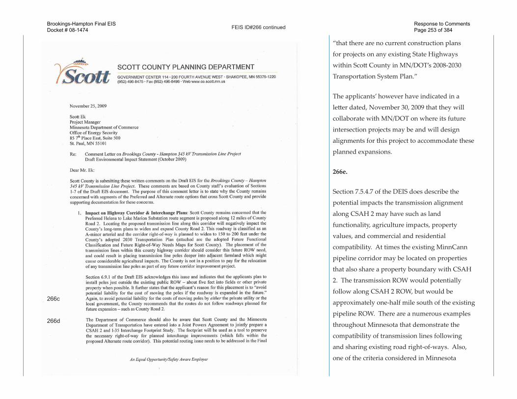
FEIS ID#262 262a. Section 6.1.6 (Existing Utilities) does address the potential conflict with existing utilities to the extent that, “The applicants have stated they would work with landowners and the rural utility providers to avoid direct or indirect impacts to public utilities.” and, “It may be necessary for the applicants to work with other public service utilities to relocate their facilities if they conflict with the location of the transmission line.” In addition, Page 6-18 of the applicants’ RPA indicates, “The proposed structures would be between 130 and 175 feet tall, typically located just outside the public road ROW. Many of these roads currently do not share a right-of-way with a transmission line, with the exception of power distribution lines serving rural residences and farmsteads. However, the Preferred Route would share right-of-way for short distances in several locations, typically collocating with other routes at entrance and exit points to substations.” An example similar to the city of Farmington’s concern with regards to County State-Aid Highway (CSAH) 50 and Denmark Avenue is discussed in the applicants’ RPA on page 6-29 and states, “In Dakota County, a home- 262a 262b Brookings-Hampton Final EIS Docket # 08-1474 Response to Comments Page 234 of 384
Transcript of Brookings County-Hampton 345 mission Line Project...

FEIS ID#262
262a.
Section 6.1.6 (Existing Utilities) does address
the potential conflict with existing utilities to
the extent that, “The applicants have stated
they would work with landowners and the
rural utility providers to avoid direct or indirect
impacts to public utilities.” and, “It may be
necessary for the applicants to work with
other public service utilities to relocate their
facilities if they conflict with the location of the
transmission line.”
In addition, Page 6-18 of the applicants’ RPA
indicates, “The proposed structures would be
between 130 and 175 feet tall, typically located
just outside the public road ROW. Many of these
roads currently do not share a right-of-way with
a transmission line, with the exception of power
distribution lines serving rural residences and
farmsteads. However, the Preferred Route would
share right-of-way for short distances in several
locations, typically collocating with other routes
at entrance and exit points to substations.”
An example similar to the city of Farmington’s
concern with regards to County State-Aid
Highway (CSAH) 50 and Denmark Avenue
is discussed in the applicants’ RPA on page
6-29 and states, “In Dakota County, a home-
262a
262b
Brookings-Hampton Final EISDocket # 08-1474
Response to Comments Page 234 of 384

FEIS ID#262 continued
based daycare facility is located along TH 3/
Chippendale Avenue West, south of the City
of Farmington. Electric distribution lines, cable
television and telephone lines are located along
each of the roads the Preferred Route would
follow, providing service to the adjacent homes
and businesses. These lines do not present a
barrier to construction and operation of the
transmission line. It may be necessary for the
applicants to work with other public service
utilities to relocate their facilities if they conflict
with the location of the transmission line.” All
potential routes are likely to present potential
conflicts with other utilities that will have to be
addressed during detailed design.
262b.
House locations and numbers (within 500-
feet) were reviewed again for the FEIS. The
updated house counts (modified slightly from
DEIS) and the methods used to produce these
data are provided in Appendix F. In addition,
we did count multi-unit dwellings where
individual units—such as townhomes—were
distinguishable. Because the route centerlines
we used to calculate the house counts and
other methodology differences, our house
262c
262d
Brookings-Hampton Final EISDocket # 08-1474
Response to Comments Page 235 of 384

FEIS ID#262 continued
counts may not match precisely with the City of
Farmington’s.
262c.
We have prepared a map of the commercial
buildings within 150-feet and 500-feet of the
initial route centerline in this area that is
provided in Appendix C, map FEIS ID#262a. The
location of the fire station, for example, is shown
on this map.
262d.
Section 6.1.6 (Existing Utilities) does address
the potential conflict with existing utilities to
the extent that, “The applicants have stated
they would work with landowners and the
rural utility providers to avoid direct or indirect
impacts to public utilities.” and, “It may be
necessary for the applicants to work with other
public service utilities to relocate their facilities if
they conflict with the location of the transmission
line.” (See response to FEIS ID#262a).
262e.
The DEIS does provide overall socioeconomic
and human se�lement data for each segment
analyzed in Section 7.0 of the document. See also
response to FEIS ID#262c.
262e
Brookings-Hampton Final EISDocket # 08-1474
Response to Comments Page 236 of 384

FEIS ID#262 continued
262f.
First, regarding the runway flight path, the
height of the transmission lines would be
restricted to approximately 150-feet, which is
feasible.
However, as the comment indicates, there
is a Very High Frequency Omnidirectional
Radio Range (“VOR”) air navigation systems
and Automated Weather Observation
Stations(“AWOS”) located in this area. FAA
Order 6820.10 “VOR, VOR/DME, and VORTAC
Siting Criteria,” specifies the distance setback
requirements for trees, buildings, and metallic
structures. These regulations specify that
overhead transmission line structures with
conductors should be located beyond 1,200 feet
of the VOR antenna to avoid communication
interference. Additionally, metallic structures are
required to subtend vertical angles of 1.2 degrees
or less, measured from the ground elevation of
the VOR facility. Therefore, according to these
FAA guidelines, a VOR air navigational station
should not be located within 6,206 feet away
from a 130 foot high steel structure in order to
avoid potential interference with the operation of
the facility. Structures of 175 feet in height should
be 8,354 feet away from a VOR.
262f
262g
Brookings-Hampton Final EISDocket # 08-1474
Response to Comments Page 237 of 384

FEIS ID#262 continued
The location of the Airlake Airport VOR in
this area and the applicable setbacks is shown
on map FEIS ID#262b in Appendix C. As
illustrated by this map and the comment, route
alternative 6P-05 crosses within 50 feet of this
VOR. As a result, this alternative is not a viable
option. Likewise 6P-04 is just outside the 1,200
foot setback, making this alternative route an
unlikely option also. Finally, alternative route
6P-01 runs about 4000 feet away from the VOR,
which is within the FAA structure setback
recommendation. A definitive decision on
what the acceptable height of a transmission
line structure or design would be for this route
segment could only be made by filing a notice
request from the FAA and/or MN/DOT. The
applicants would need to file all necessary notice
requirements with FAA and work with both FAA
and MN/DOT to ensure compatibility between
the transmission lines and air navigation stations
and equipment during detailed design should
this route be selected.
262g.
The detailed wetland data used in the DEIS
is provided in Appendix B of the FEIS (FEIS
ID#46). In addition, the detailed maps of the
NWI wetlands in the vicinity of the property near
262h
262i
262j
Brookings-Hampton Final EISDocket # 08-1474
Response to Comments Page 238 of 384

FEIS ID#262 continued
Farmington are shown on Figures LH7A and
LH7B in Appendix A of the DEIS. Wetland data
in the DEIS are based on the National Wetland
Inventory. No wetland delineations will be
conducted until a route has been chosen where
necessary. Therefore, the DEIS wetland data may
not match the City of Farmington data precisely.
See also response to FEIS ID#188a.
262h.
Comments noted.
262i.
The DEIS maps note the locations of publically
available data of locations of local parks,
streams, and similar resources available at the
time the RPA and DEIS were completed. The
additional existing or planned park and facilities
highlighted in the comment are noted.
262j.
Comments noted.
Brookings-Hampton Final EISDocket # 08-1474
Response to Comments Page 239 of 384
FEIS ID#264
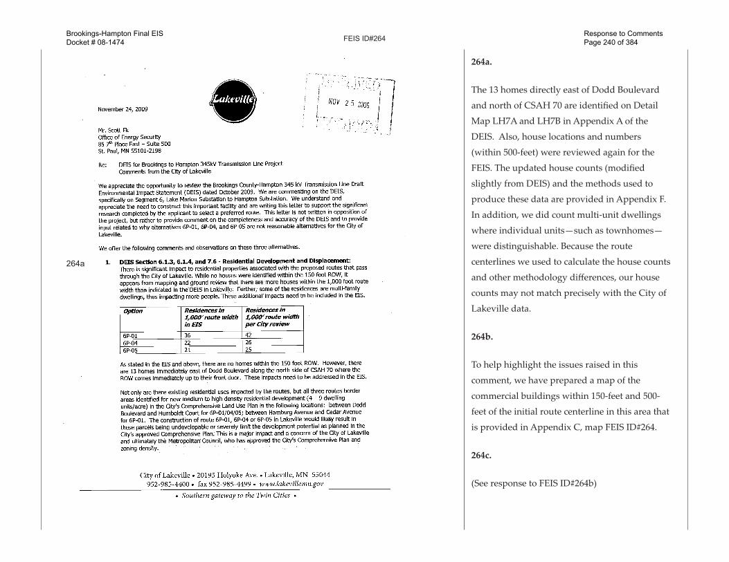
264a.
The 13 homes directly east of Dodd Boulevard
and north of CSAH 70 are identified on Detail
Map LH7A and LH7B in Appendix A of the
DEIS. Also, house locations and numbers
(within 500-feet) were reviewed again for the
FEIS. The updated house counts (modified
slightly from DEIS) and the methods used to
produce these data are provided in Appendix F.
In addition, we did count multi-unit dwellings
where individual units—such as townhomes—
were distinguishable. Because the route
centerlines we used to calculate the house counts
and other methodology differences, our house
counts may not match precisely with the City of
Lakeville data.
264b.
To help highlight the issues raised in this
comment, we have prepared a map of the
commercial buildings within 150-feet and 500-
feet of the initial route centerline in this area that
is provided in Appendix C, map FEIS ID#264.
264c.
(See response to FEIS ID#264b)
264a
Brookings-Hampton Final EISDocket # 08-1474
Response to Comments Page 240 of 384

FEIS ID#264 continued
264d.
(See response to FEIS ID#262d)
264e.
Section 7.6.4.9 of the DEIS addresses potential
impacts to Airlake Airport. See also response to
FEIS ID#262f.
264f.
Section 6.1.1 of the DEIS describes potential
visual and aesthetic impacts of the project
and mitigation for those impacts. The DEIS
recognizes that the visual profile of transmission
line structures and wires may decrease the
perceived aesthetic quality of property. The
level of impact to visual resources generally
depends on the sensitivity and exposure of a
particular viewer and can vary greatly from one
individual to the next. Therefore, it is difficult
to predict whether a transmission line project
would alter the perceived visual character of
the environment, or viewshed, and constitute a
negative visual impact.
Measures to mitigate instances where existing
HVTLs exist along a corrider would be to require
that the applicants co-locate a new transmission
line and the existing HVTL on new triple-circuit
264c
264c
Brookings-Hampton Final EISDocket # 08-1474
Response to Comments Page 241 of 384

FEIS ID#264 continued
structures along that ROW. There is also the
option to bury or underground either the new or
existing transmission line in that area. Section 4.6
of the DEIS discusses underground options.
Areas where there is a potential for transmission
line proliferation such as described by the city
of Lakeville will be evaluated in greater detail to
ensure mitigation methods are commensurate
with the final placement of the proposed
transmission line. That is, if the proposed
line where to be placed along side an existing
transmission or distribution line the potential
visual impacts, impacts to agriculture lands
and structures may significantly change from
the potential impacts initially discussed in the
DEIS, therefore mitigation methods would need
to address such changes identified during the
final design, should a permit be issued. For
instance the applicants have indicated that if the
alignment were along county road 50 the 345kV
would likely be placed on the south side of the
road. A 115kV line exists along the north side.
At Denmark the applicants have indicated the
345kV lines would be run along the west side of
the road as a 69kV lines exist along the east side
of Denmark. The loss of flexibility this flexibility
to move to the other side of the road in routes
segments such as, especially in the urban fringe
264d
Brookings-Hampton Final EISDocket # 08-1474
Response to Comments Page 242 of 384

FEIS ID#264 continued
areas like Highway 50 in Farmington, do increase
the potential for greater impact.
Finally, please refer to the discussion on
problematic routes in Section 1.0 which
identifies routes that have been determined
to be problematic when evaluated against to
comparable alternatives.
264g.
(See response to FEIS ID#262g)
264g.
(See response to FEIS ID#262i)
264h.
Comments noted.
264d
264e
264f
Brookings-Hampton Final EISDocket # 08-1474
Response to Comments Page 243 of 384

FEIS ID#264 continued
264g
264h
Brookings-Hampton Final EISDocket # 08-1474
Response to Comments Page 244 of 384

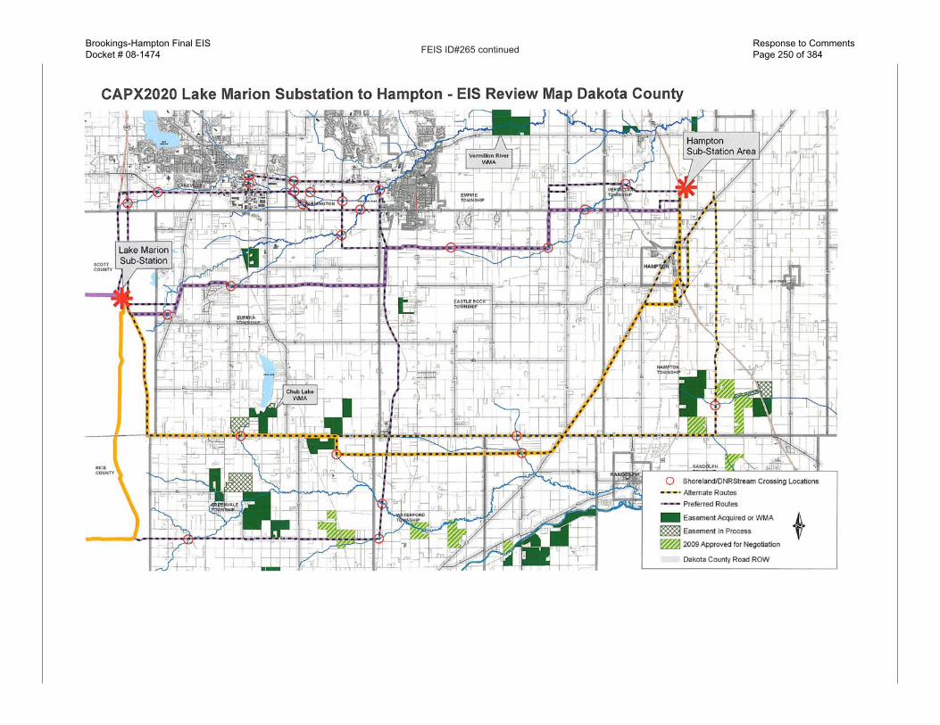
FEIS ID#265
265a.
Should a route be chosen that would necessitate
crossing of the Vermillion River, the applicants
would likely require a license to cross Public
Waters from the DNR. In addition, a route
permit, if issued by the Commission, would
typically include conditions that would require
a permi�ee to use best management practices
when constructing near wetlands or riparian
areas and may include language such as, “The
placement of power pole structures, shall be
avoided to the maximum extent possible by
placing these structures above the floodplain
contours outside of the designated floodplain,
and by spanning the floodplain with the
transmission line.”
Also, if construction activities would result in
the disturbance of one acre or more of soils, a
National Pollutant Discharge Elimination System
(NPDES) stormwater permit from the
Minnesota Pollution Control Agency (MPCA)
would is required.
265b.
The DEIS evaluated the alternative route
proposed by the applicants using an assumed
alignment that would have the transmission
Brookings-Hampton Final EISDocket # 08-1474
Response to Comments Page 245 of 384

FEIS ID#265 continued
structure centerline following along 280th Street/
County Road 86 turning south and following the
boundary between Sections 1 and 2 of Greenvale
Township. The alignment as evaluated in the
DEIS would not encroach upon either of the
above conservation easements identified by
Dakota County. In addition, special conditions
could be included in a route permit that would
assist in mitigating concerns related to three
areas by limiting route width and area.
Section 8.6 (Other Approvals) of the DEIS
describes the approach the applicants would
likely take should Farmland and Natural Areas
Project (FNAP) lands need to be encroached
upon and states, “Applicants would likely
work with landowners, local government
entities administering such programs, and the
sponsoring federal agency on a site-by-site basis
to coordinate the approvals necessary for placing
the transmission facilities on these lands.
In addition, a HVTL route permit, if issued by the
Commission, would supersede and preempt all
zoning, building, or land use rules, regulations,
or ordinances promulgated by regional, county,
local and special purpose government under
Minnesota Statute 216E.10, subd. 1.
265a
265b
Brookings-Hampton Final EISDocket # 08-1474
Response to Comments Page 246 of 384
FEIS ID#265 continued
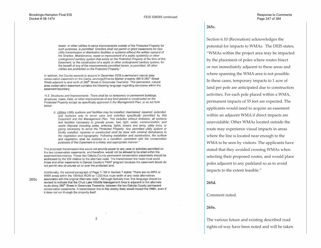
265c.
Section 6.10 (Recreation) acknowledges the
potential for impacts to WMAs. The DEIS states,
“WMAs within the project area may be impacted
by the placement of poles where routes bisect
or run immediately adjacent to these areas and
where spanning the WMA area is not possible.
In these cases, temporary impacts to 1 acre of
land per pole are anticipated due to construction
activities. For each pole placed within a WMA,
permanent impacts of 55 feet are expected. The
applicants would need to acquire an easement
within an adjacent WMA if direct impacts are
unavoidable. Other WMAs located outside the
route may experience visual impacts in areas
where the line is located near enough to the
WMA to be seen by visitors. The applicants have
stated that they avoided crossing WMAs when
selecting their proposed routes, and would place
poles adjacent to any parkland so as to avoid
impacts to the extent feasible.”
265d.
Comment noted.
265e.
The various future and existing described road
rights-of-way have been noted and will be taken
265c
Brookings-Hampton Final EISDocket # 08-1474
Response to Comments Page 247 of 384

FEIS ID#265 continued
into consideration in the recommendations
and eventual decision on the best route for the
proposed transmission line.
265e
265d
Brookings-Hampton Final EISDocket # 08-1474
Response to Comments Page 248 of 384

FEIS ID#265 continuedBrookings-Hampton Final EISDocket # 08-1474
Response to Comments Page 249 of 384
FEIS ID#265 continuedBrookings-Hampton Final EISDocket # 08-1474
Response to Comments Page 250 of 384

FEIS ID#265 continuedBrookings-Hampton Final EISDocket # 08-1474
Response to Comments Page 251 of 384

FEIS ID#266
266a.
A route permit, if issued by the Commission,
would typically include conditions that would
require a permi�ee to use best management
practices when constructing near wetlands or
riparian areas and may include language such
as, “The placement of power pole structures,
shall be avoided to the maximum extent
possible by placing these structures above the
floodplain contours outside of the designated
floodplain, and by spanning the floodplain with
the transmission line.” See also response to FEIS
ID#263h.
266b.
(See response to FEIS ID#188a)
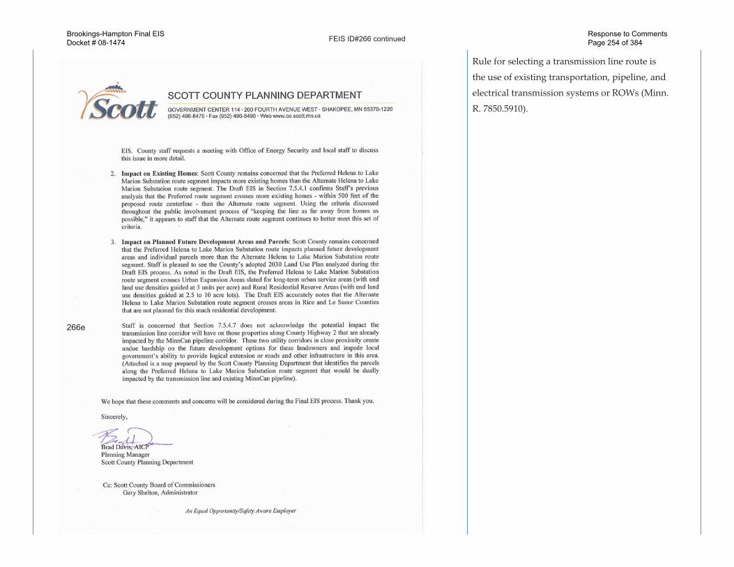
266c.
The DEIS does not discuss policy issues
surrounding whether utilities or local-
government should be liable for the cost to
relocate utility poles when roadways are
widened, as indicated in Section 3.3.
266d.
The Sco� County 2030 Comprehensive Plan
Update, dated March 24, 2009, indicates,
Ek, Scott (COMM)
From: Davis, Brad [[email protected]]Sent: Wednesday, November 25, 2009 3:10 PMTo: Ek, Scott (COMM)Subject: Scott Co Comment Letter on Draft EISAttachments: Draft EIS comment letter.pdf
Page 1 of 1
11/28/2009
Hello�Scott,���A�hard�copy�of�the�attached�pdf�comment�letter�with�cited�attachments�is�being�sent�in�the�mail�to�you�this�morning,�in�advance�of�the�November�30�comment�period�deadline.������In�addition�to�the�comments�contained�in�this�memo,�our�Natural�Resources�manager�adds�another�comment:�Any�river�crossing�in�the�county�should�avoid�tower�footprint�in�the�buffer�area.��A�conservative�approach�would�be�to�apply�a�150’�buffer�to�each�riverbank�for�all�crossings.��Finally,�wetland�impacts�should�be�avoided�when�possible�and�if�unavoidable�should�then�abide�by�all�WCA�requirements.�����Brad�Davis,�AICP�Planning�Manager�Scott�County�Planning�Department�[email protected]�(952)�496�8654���
266a
266b
Brookings-Hampton Final EISDocket # 08-1474
Response to Comments Page 252 of 384
FEIS ID#266 continued
“that there are no current construction plans
for projects on any existing State Highways
within Sco� County in MN/DOT’s 2008-2030
Transportation System Plan.”
The applicants’ however have indicated in a
le�er dated, November 30, 2009 that they will
collaborate with MN/DOT on where its future
intersection projects may be and will design
alignments for this project to accommodate these
planned expansions.
266e.
Section 7.5.4.7 of the DEIS does describe the
potential impacts the transmission alignment
along CSAH 2 may have such as land
functionality, agriculture impacts, property
values, and commercial and residential
compatibility. At times the existing MinnCann
pipeline corridor may be located on properties
that also share a property boundary with CSAH
2. The transmission ROW would potentially
follow along CSAH 2 ROW, but would be
approximately one-half mile south of the existing
pipeline ROW. There are a numerous examples
throughout Minnesota that demonstrate the
compatibility of transmission lines following
and sharing existing road right-of-ways. Also,
one of the criteria considered in Minnesota
266d
266c
Brookings-Hampton Final EISDocket # 08-1474
Response to Comments Page 253 of 384
FEIS ID#266 continued
Rule for selecting a transmission line route is
the use of existing transportation, pipeline, and
electrical transmission systems or ROWs (Minn.
R. 7850.5910).
266e
Brookings-Hampton Final EISDocket # 08-1474
Response to Comments Page 254 of 384

FEIS ID#266 continuedBrookings-Hampton Final EISDocket # 08-1474
Response to Comments Page 255 of 384

FEIS ID#267
267a.
Comment noted. The AIMP has been a�ached to
the FEIS as Appendix D.
Comments on DEIS for Brookings Co. - Hampton 345 Transmision Line Project (CapX2020)Patton, Bob (MDA)
Dear Mr. Ek:
I have reviewed the Draft Environmental Impact Statement on behalf of the Minnesota Department of Agriculture. The discussion of agriculture in Section 6.81 of the DEIS, the related discussion of stray voltage in Section 6.2, and segment-specific discussion in Section 7.0 appears to be complete and adequate.
We request that the full text of the Agricultural Impact Mitigation Plan be included in the Final Environmental Impact Statement as an attachment. Inclusion of the AIMP in the FEIS should help make the document more accessible to farmers and landowners potentially impacted by the power line.
Thank you for the opportunity to comment. Please let me know if you have any questions.
Sincerely,
Bob Patton
Robert Patton, AICPLand Use and Environmental Review CoordinatorAgricultural Development and Financial Assistance DivisionMinnesota Department of Agriculture625 Robert Street NorthSaint Paul, MN 55155-2538
Ph: 651-201-6226Fx: 651-201-6120
Sent: Monday, November 30, 2009 9:28 AM
To: Ek, Scott (COMM)
Cc: Poorker, Craig [[email protected]] ; Rasmussen, Pamela [[email protected]] ; Ross McCalib, Laureen [[email protected]] ; Kinney, Robin (MDA); Scheffert, Peter (MDA); Hanks, Mary (MDA); Moynihan, Meg (MDA); Balk, Becky (MDA)
Page 1 of 1Comments on DEIS for Brookings Co. - Hampton 345 Transmision Line Project (CapX2020)
11/30/2009https://webmail.state.mn.us/owa/?ae=Item&t=IPM.Note&id=RgAAAADorgEoXrmgT6NvkGn0VKroB...
267a
Brookings-Hampton Final EISDocket # 08-1474
Response to Comments Page 256 of 384

FEIS ID#268
(See response to FEIS ID#267)
Ek, Scott (COMM)
From: Patton, Bob (MDA)Sent: Monday, November 30, 2009 9:29 AMTo: Ek, Scott (COMM)Cc: Poorker, Craig; Rasmussen, Pamela; Ross McCalib, Laureen; Kinney, Robin (MDA); Scheffert, Peter (MDA);
Hanks, Mary (MDA); Moynihan, Meg (MDA); Balk, Becky (MDA)Subject: Comments on DEIS for Brookings Co. - Hampton 345 Transmision Line Project (CapX2020)
Page 1 of 1
11/30/2009
Dear Mr. Ek:
I have reviewed the Draft Environmental Impact Statement on behalf of the Minnesota Department of Agriculture. The discussion of agriculture in Section 6.81 of the DEIS, the related discussion of stray voltage in Section 6.2, and segment-specific discussion in Section 7.0 appears to be complete and adequate.
We request that the full text of the Agricultural Impact Mitigation Plan be included in the Final Environmental Impact Statement as an attachment. Inclusion of the AIMP in the FEIS should help make the document more accessible to farmers and landowners potentially impacted by the power line.
Thank you for the opportunity to comment. Please let me know if you have any questions.
Sincerely,
Bob Patton
Robert Patton, AICPLand Use and Environmental Review CoordinatorAgricultural Development and Financial Assistance DivisionMinnesota Department of Agriculture625 Robert Street NorthSaint Paul, MN 55155-2538
Ph: 651-201-6226Fx: 651-201-6120
Brookings-Hampton Final EISDocket # 08-1474
Response to Comments Page 257 of 384

FEIS ID#269
269a.
To more easily convey the information about
the proposed project it was divided in to six
segments, each of which were described in
Sections 7.1 to 7.6 of the DEIS.
Appendix E of the DEIS includes a Data
Summary Table that presents quantitative data
for portions of the applicants’ preferred and
alternative routes and alternative route segments
located within each of the six project segments
as organized in Section 7 of the DEIS. For each
separate route segment the table provides the
potential number of acres of WMAs at different
distances from the route alignment used in the
DEIS, number of shallow lakes, wild and scenic
river crossings, scientific natural areas (SNAs),
acres of cropland, marsh, aquatic, among others.
269b.
The potential impacts and mitigation described
in the DEIS are for a new 237 to 262-mile, 345
kilovolt (kV) transmission line beginning at
the state’s western border near Hendricks,
Minnesota, and ending south of the Twin
Cities metro area near Hampton, Minnesota,
as proposed by Great River Energy and Xcel
Energy. The proposed project would also
include the construction of four new substations
and the expansion of four existing substations.
269a
269b
269c
269d
269e
Brookings-Hampton Final EISDocket # 08-1474
Response to Comments Page 258 of 384

FEIS ID#269 continued
Section 6.10 (Recreation) acknowledges the
potential for impacts to WMAs. The DEIS states,
“WMAs within the project area may be impacted
by the placement of poles where routes bisect
or run immediately adjacent to these areas and
where spanning the WMA area is not possible.
In these cases, temporary impacts to 1 acre of
land per pole are anticipated due to construction
activities. For each pole placed within a WMA,
permanent impacts of 55 feet are expected. The
applicants would need to acquire an easement
within an adjacent WMA if direct impacts are
unavoidable. Other WMAs located outside the
route may experience visual impacts in areas
where the line is located near enough to the
WMA to be seen by visitors. The applicants have
stated that they avoided crossing WMAs when
selecting their proposed routes, and would place
poles adjacent to any parkland so as to avoid
impacts to the extent feasible.”
269c.
(See response to FEIS ID#269a)
269d.
The information provided in the comment may
be presented as a condition in a route permit, if
issued by the Commission.
269af
269g
269h
269i
269j
269k
269o
269n
269m
269l
Brookings-Hampton Final EISDocket # 08-1474
Response to Comments Page 259 of 384

FEIS ID#269 continued
269e.
Comment noted.
269f.
Comment noted.
269g.
Comment noted.
269h.
River crossing as it pertains to transmission
line structures and construction techniques are
addressed in Section 4.0 of the DEIS. Section
6.1.1 describes aesthetic and visual impacts of
the proposed transmission facility including
potential mitigation methods when it would be
necessary to cross rivers or streams. Sections
6.10 (Recreation), 6.11 (Water Resources), 6.12
(Flora and Fauna), 6.13 (Rare and Unique Natural
Resources) of the DEIS detail the potential
impacts and mitigation methods associated
with the identified river crossings proposed as
part of the project. Section 7.0 of the DEIS also
addresses potential river crossing impacts and
mitigation with respect to a specific segments of
the proposed project.
269v
269u
269t
269s
269r
269q
269p
269w
269x
Brookings-Hampton Final EISDocket # 08-1474
Response to Comments Page 260 of 384

FEIS ID#269 continued
269i.
This would typically be a condition of the route
permit.
269j.
Data on forested wetlands acres is provided in
FEIS Appendix B, FEIS ID#46.
269k.
Noxious weeds and invasive vegetation are
addressed in Section 6.12.1.3 of the DEIS
269l.
Comment noted.
269m.
Comments noted.
269n.
Comment noted.
269o.
(See response to FEIS ID#265a)
269p.
The Leusher-Barnum WMA is located south
of 275th Street where the transmission line
alignment depicted in the DEIS would follow
Brookings-Hampton Final EISDocket # 08-1474
Response to Comments Page 261 of 384
FEIS ID#269 continued
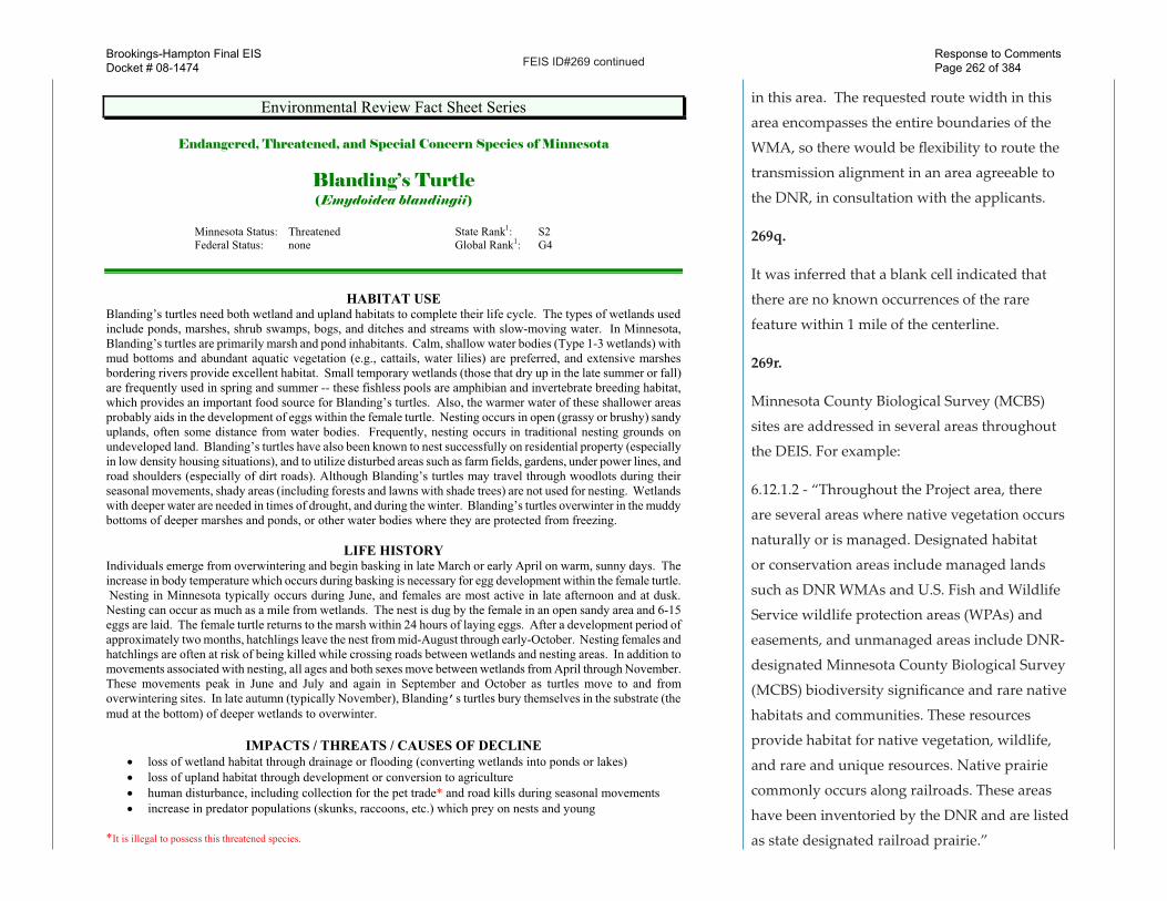
Environmental Review Fact Sheet Series
Endangered, Threatened, and Special Concern Species of Minnesota
Blanding’s Turtle (Emydoidea blandingii)
Minnesota Status: Threatened State Rank1: S2 Federal Status: none Global Rank1: G4
HABITAT USE Blanding’s turtles need both wetland and upland habitats to complete their life cycle. The types of wetlands used include ponds, marshes, shrub swamps, bogs, and ditches and streams with slow-moving water. In Minnesota, Blanding’s turtles are primarily marsh and pond inhabitants. Calm, shallow water bodies (Type 1-3 wetlands) with mud bottoms and abundant aquatic vegetation (e.g., cattails, water lilies) are preferred, and extensive marshes bordering rivers provide excellent habitat. Small temporary wetlands (those that dry up in the late summer or fall) are frequently used in spring and summer -- these fishless pools are amphibian and invertebrate breeding habitat, which provides an important food source for Blanding’s turtles. Also, the warmer water of these shallower areas probably aids in the development of eggs within the female turtle. Nesting occurs in open (grassy or brushy) sandy uplands, often some distance from water bodies. Frequently, nesting occurs in traditional nesting grounds on undeveloped land. Blanding’s turtles have also been known to nest successfully on residential property (especially in low density housing situations), and to utilize disturbed areas such as farm fields, gardens, under power lines, and road shoulders (especially of dirt roads). Although Blanding’s turtles may travel through woodlots during their seasonal movements, shady areas (including forests and lawns with shade trees) are not used for nesting. Wetlands with deeper water are needed in times of drought, and during the winter. Blanding’s turtles overwinter in the muddy bottoms of deeper marshes and ponds, or other water bodies where they are protected from freezing. LIFE HISTORY Individuals emerge from overwintering and begin basking in late March or early April on warm, sunny days. The increase in body temperature which occurs during basking is necessary for egg development within the female turtle. Nesting in Minnesota typically occurs during June, and females are most active in late afternoon and at dusk. Nesting can occur as much as a mile from wetlands. The nest is dug by the female in an open sandy area and 6-15 eggs are laid. The female turtle returns to the marsh within 24 hours of laying eggs. After a development period of approximately two months, hatchlings leave the nest from mid-August through early-October. Nesting females and hatchlings are often at risk of being killed while crossing roads between wetlands and nesting areas. In addition to movements associated with nesting, all ages and both sexes move between wetlands from April through November. These movements peak in June and July and again in September and October as turtles move to and from overwintering sites. In late autumn (typically November), Blanding’s turtles bury themselves in the substrate (the mud at the bottom) of deeper wetlands to overwinter. IMPACTS / THREATS / CAUSES OF DECLINE
�� loss of wetland habitat through drainage or flooding (converting wetlands into ponds or lakes) �� loss of upland habitat through development or conversion to agriculture �� human disturbance, including collection for the pet trade* and road kills during seasonal movements �� increase in predator populations (skunks, raccoons, etc.) which prey on nests and young
*It is illegal to possess this threatened species.
in this area. The requested route width in this
area encompasses the entire boundaries of the
WMA, so there would be flexibility to route the
transmission alignment in an area agreeable to
the DNR, in consultation with the applicants.
269q.
It was inferred that a blank cell indicated that
there are no known occurrences of the rare
feature within 1 mile of the centerline.
269r.
Minnesota County Biological Survey (MCBS)
sites are addressed in several areas throughout
the DEIS. For example:
6.12.1.2 - “Throughout the Project area, there
are several areas where native vegetation occurs
naturally or is managed. Designated habitat
or conservation areas include managed lands
such as DNR WMAs and U.S. Fish and Wildlife
Service wildlife protection areas (WPAs) and
easements, and unmanaged areas include DNR-
designated Minnesota County Biological Survey
(MCBS) biodiversity significance and rare native
habitats and communities. These resources
provide habitat for native vegetation, wildlife,
and rare and unique resources. Native prairie
commonly occurs along railroads. These areas
have been inventoried by the DNR and are listed
as state designated railroad prairie.”
Brookings-Hampton Final EISDocket # 08-1474
Response to Comments Page 262 of 384

FEIS ID#269 continued
Minnesota DNR Division of Ecological Resources Environmental Review Fact Sheet Series. Blanding’s Turtle.
2
RECOMMENDATIONS FOR AVOIDING AND MINIMIZING IMPACTS These recommendations apply to typical construction projects and general land use within Blanding’s turtle habitat, and are provided to help local governments, developers, contractors, and homeowners minimize or avoid detrimental impacts to Blanding’s turtle populations. List 1 describes minimum measures which we recommend to prevent harm to Blanding’s turtles during construction or other work within Blanding’s turtle habitat. List 2 contains recommendations which offer even greater protection for Blanding’s turtles populations; this list should be used in addition to the first list in areas which are known to be of state-wide importance to Blanding’s turtles (contact the DNR’s Natural Heritage and Nongame Research Program if you wish to determine if your project or home is in one of these areas), or in any other area where greater protection for Blanding’s turtles is desired.
List 1. Recommendations for all areas inhabited by Blanding’s turtles.
List 2. Additional recommendations for areas known to be of state-wide importance to Blanding’s turtles.
GENERAL
A flyer with an illustration of a Blanding’s turtle should be given to all contractors working in the area. Homeowners should also be informed of the presence of Blanding’s turtles in the area.
Turtle crossing signs can be installed adjacent to road-crossing areas used by Blanding’s turtles to increase public awareness and reduce road kills.
Turtles which are in imminent danger should be moved, by hand, out of harms way. Turtles which are not in imminent danger should be left undisturbed.
Workers in the area should be aware that Blanding’s turtles nest in June, generally after 4pm, and should be advised to minimize disturbance if turtles are seen.
If a Blanding’s turtle nests in your yard, do not disturb the nest.
If you would like to provide more protection for a Blanding’s turtle nest on your property, see “Protecting Blanding’s Turtle Nests” on page 3 of this fact sheet.
Silt fencing should be set up to keep turtles out of construction areas. It is critical that silt fencing be removed after the area has been revegetated.
Construction in potential nesting areas should be limited to the period between September 15 and June 1 (this is the time when activity of adults and hatchlings in upland areas is at a minimum).
WETLANDS
Small, vegetated temporary wetlands (Types 2 & 3) should not be dredged, deepened, filled, or converted to storm water retention basins (these wetlands provide important habitat during spring and summer).
Shallow portions of wetlands should not be disturbed during prime basking time (mid morning to mid- afternoon in May and June). A wide buffer should be left along the shore to minimize human activity near wetlands (basking Blanding’s turtles are more easily disturbed than other turtle species).
Wetlands should be protected from pollution; use of fertilizers and pesticides should be avoided, and run-off from lawns and streets should be controlled. Erosion should be prevented to keep sediment from reaching wetlands and lakes.
Wetlands should be protected from road, lawn, and other chemical run-off by a vegetated buffer strip at least 50' wide. This area should be left unmowed and in a natural condition.
ROADS
Roads should be kept to minimum standards on widths and lanes (this reduces road kills by slowing traffic and reducing the distance turtles need to cross).
Tunnels should be considered in areas with concentrations of turtle crossings (more than 10 turtles per year per 100 meters of road), and in areas of lower density if the level of road use would make a safe crossing impossible for turtles. Contact your DNR Regional Nongame Specialist for further information on wildlife tunnels.
Roads should be ditched, not curbed or below grade. If curbs must be used, 4 inch high curbs at a 3:1 slope are preferred (Blanding’s turtles have great difficulty climbing traditional curbs; curbs and below grade roads trap turtles on the road and can cause road kills).
Roads should be ditched, not curbed or below grade.
269s.
Comment noted.
269t.
This would typically be a condition of the route
permit.
269u.
This would typically be a condition of the route
permit.
269v.
This would typically be a condition of the route
permit.
269w.
The applicants’ have narrowed down the
potential locations for the new and existing
substations in The Testimony of Craig Poorker
on Behalf of Applicants, dated October 13, 2009
(FEIS Appendix E).
Hazel Creek Substation (Preferrred and •
Alternative) - southeast corner of the
intersection of 520th Street (County Road B3)
and 260th Avenue in Granite Falls.
Cedar Mountain Substation (Preffered) - •
Camp Township, Renville County at the
Brookings-Hampton Final EISDocket # 08-1474
Response to Comments Page 263 of 384

FEIS ID#269 continued
Minnesota DNR Division of Ecological Resources Environmental Review Fact Sheet Series. Blanding’s Turtle.
3
ROADS cont. Culverts between wetland areas, or between wetland areas and nesting areas, should be 36 inches or greater in diameter, and elliptical or flat-bottomed.
Road placement should avoid separating wetlands from adjacent upland nesting sites, or these roads should be fenced to prevent turtles from attempting to cross them (contact your DNR Nongame Specialist for details).
Wetland crossings should be bridged, or include raised roadways with culverts which are 36 in or greater in diameter and flat-bottomed or elliptical (raised roadways discourage turtles from leaving the wetland to bask on roads).
Road placement should avoid bisecting wetlands, or these roads should be fenced to prevent turtles from attempting to cross them (contact your DNR Nongame Specialist for details). This is especially important for roads with more than 2 lanes.
Culverts under roads crossing streams should be oversized (at least twice as wide as the normal width of open water) and flat-bottomed or elliptical.
Roads crossing streams should be bridged.
UTILITIES
Utility access and maintenance roads should be kept to a minimum (this reduces road-kill potential).
Because trenches can trap turtles, trenches should be checked for turtles prior to being backfilled and the sites should be returned to original grade.
LANDSCAPING AND VEGETATION MANAGEMENT
Terrain should be left with as much natural contour as possible.
As much natural landscape as possible should be preserved (installation of sod or wood chips, paving, and planting of trees within nesting habitat can make that habitat unusable to nesting Blanding’s turtles).
Graded areas should be revegetated with native grasses and forbs (some non-natives form dense patches through which it is difficult for turtles to travel).
Open space should include some areas at higher elevations for nesting. These areas should be retained in native vegetation, and should be connected to wetlands by a wide corridor of native vegetation.
Vegetation management in infrequently mowed areas -- such as in ditches, along utility access roads, and under power lines -- should be done mechanically (chemicals should not be used). Work should occur fall through spring (after October 1st and before June 1st ).
Ditches and utility access roads should not be mowed or managed through use of chemicals. If vegetation management is required, it should be done mechanically, as infrequently as possible, and fall through spring (mowing can kill turtles present during mowing, and makes it easier for predators to locate turtles crossing roads).
Protecting Blanding’s Turtle Nests: Most predation on turtle nests occurs within 48 hours after the eggs are laid. After this time, the scent is gone from the nest and it is more difficult for predators to locate the nest. Nests more than a week old probably do not need additional protection, unless they are in a particularly vulnerable spot, such as a yard where pets may disturb the nest. Turtle nests can be protected from predators and other disturbance by covering them with a piece of wire fencing (such as chicken wire), secured to the ground with stakes or rocks. The piece of fencing should measure at least 2 ft. x 2 ft., and should be of medium sized mesh (openings should be about 2 in. x 2 in.). It is very important that the fencing be removed before August 1st so the young turtles can escape from the nest when they hatch! REFERENCES 1Association for Biodiversity Information. “Heritage Status: Global, National, and Subnational Conservation
Status Ranks.” NatureServe. Version 1.3 (9 April 2001). http://www.natureserve.org/ranking.htm (15 April 2001).
Coffin, B., and L. Pfannmuller. 1988. Minnesota’s Endangered Flora and Fauna. University of Minnesota Press, Minneapolis, 473 pp.
26 northwest corner of the intersection of
County Road 3 and 640th Avenue.
Cedar Mountain Substation (Alternative) - •
Birch Cooley Township, Renville County, on
the west side of 380th Street, ¼ mile north of
County Highway 12.
Helena Substation (Preferred) - southeast •
corner of the intersection of 231st Avenue
and 320th Street (County Road 28) in
Derrynane Township in Le Sueur County.
Helena Substation (Alternative) - West •
270th Street between Church Avenue and
Aberdeen Avenue in Belle Plaine Township
in Sco� County.
Hampton Substation (Preferred and •
Alternative) - Two different locations that are
each located on the west side of Highway
52 near 215th Street. One of these substation
sites is located on the north side of 215th
Street and the other is located on the south
side of 215th Street.
269x.
The sites listed by the DNR are noted and
incorporated, if not already addressed in the
DEIS. Section 6.12.1.2 (Native Vegetation) and
6.13.2 (Threatened and Endangered
Brookings-Hampton Final EISDocket # 08-1474
Response to Comments Page 264 of 384
FEIS ID#269 continued
Minnesota DNR Division of Ecological Resources Environmental Review Fact Sheet Series. Blanding’s Turtle.
4
REFERENCES (cont.) Moriarty, J. J., and M. Linck. 1994. Suggested guidelines for projects occurring in Blanding’s turtle habitat.
Unpublished report to the Minnesota DNR. 8 pp. Oldfield, B., and J. J. Moriarty. 1994. Amphibians and Reptiles Native to Minnesota. University of Minnesota
Press, Minneapolis, 237 pp. Sajwaj, T. D., and J. W. Lang. 2000. Thermal ecology of Blanding’s turtle in central Minnesota. Chelonian
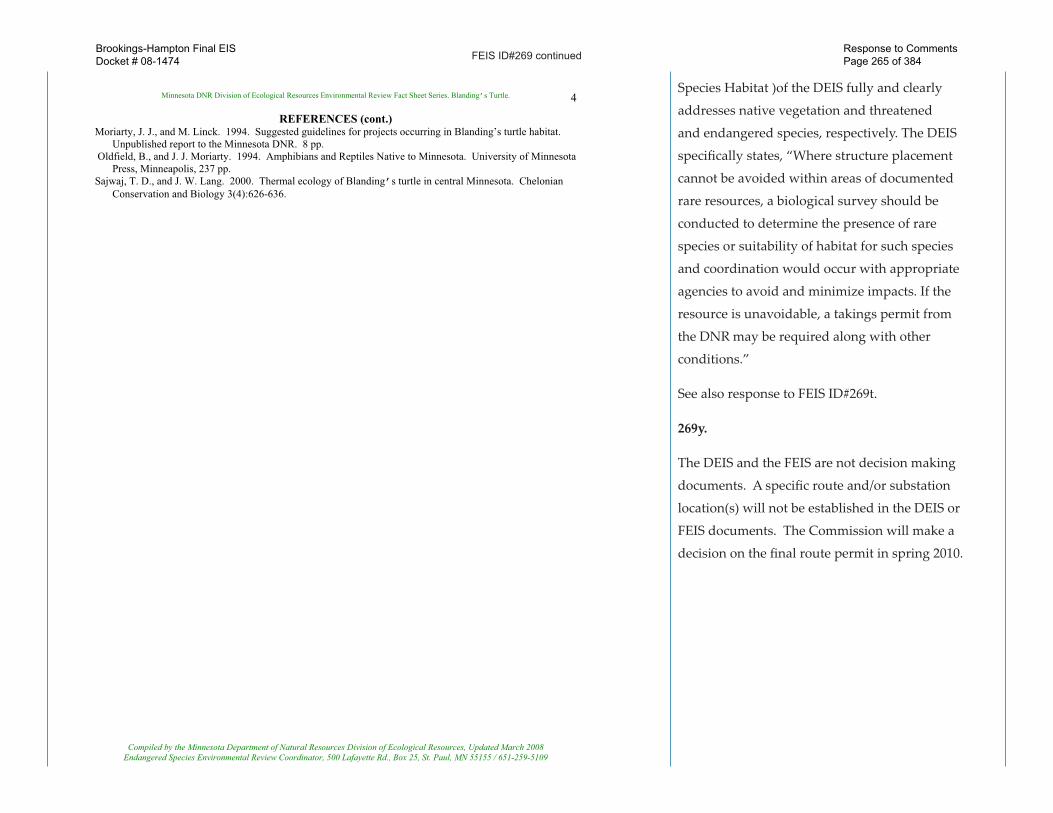
Conservation and Biology 3(4):626-636. Compiled by the Minnesota Department of Natural Resources Division of Ecological Resources, Updated March 2008 Endangered Species Environmental Review Coordinator, 500 Lafayette Rd., Box 25, St. Paul, MN 55155 / 651-259-5109
Species Habitat )of the DEIS fully and clearly
addresses native vegetation and threatened
and endangered species, respectively. The DEIS
specifically states, “Where structure placement
cannot be avoided within areas of documented
rare resources, a biological survey should be
conducted to determine the presence of rare
species or suitability of habitat for such species
and coordination would occur with appropriate
agencies to avoid and minimize impacts. If the
resource is unavoidable, a takings permit from
the DNR may be required along with other
conditions.”
See also response to FEIS ID#269t.
269y.
The DEIS and the FEIS are not decision making
documents. A specific route and/or substation
location(s) will not be established in the DEIS or
FEIS documents. The Commission will make a
decision on the final route permit in spring 2010.
Brookings-Hampton Final EISDocket # 08-1474
Response to Comments Page 265 of 384
FEIS ID#269 continued
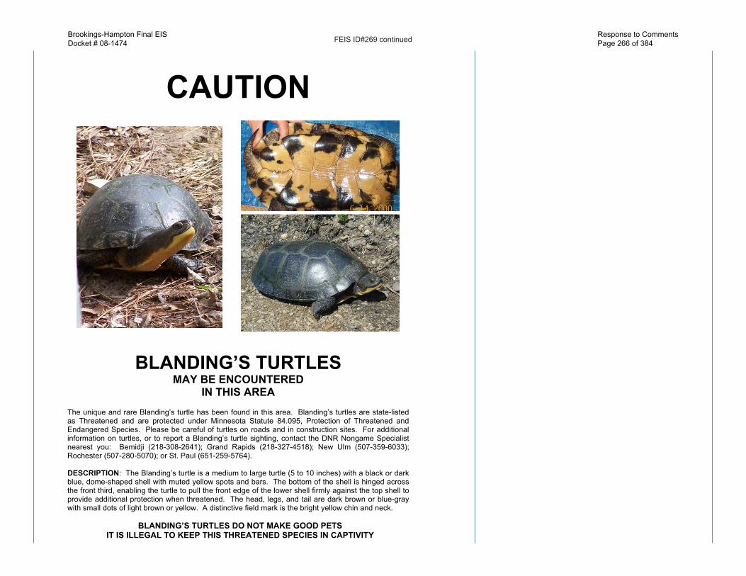
CAUTION
BLANDING’S TURTLES MAY BE ENCOUNTERED
IN THIS AREA The unique and rare Blanding’s turtle has been found in this area. Blanding’s turtles are state-listed as Threatened and are protected under Minnesota Statute 84.095, Protection of Threatened and Endangered Species. Please be careful of turtles on roads and in construction sites. For additional information on turtles, or to report a Blanding’s turtle sighting, contact the DNR Nongame Specialist nearest you: Bemidji (218-308-2641); Grand Rapids (218-327-4518); New Ulm (507-359-6033); Rochester (507-280-5070); or St. Paul (651-259-5764). DESCRIPTION: The Blanding’s turtle is a medium to large turtle (5 to 10 inches) with a black or dark blue, dome-shaped shell with muted yellow spots and bars. The bottom of the shell is hinged across the front third, enabling the turtle to pull the front edge of the lower shell firmly against the top shell to provide additional protection when threatened. The head, legs, and tail are dark brown or blue-gray with small dots of light brown or yellow. A distinctive field mark is the bright yellow chin and neck.
BLANDING’S TURTLES DO NOT MAKE GOOD PETS
IT IS ILLEGAL TO KEEP THIS THREATENED SPECIES IN CAPTIVITY
Brookings-Hampton Final EISDocket # 08-1474
Response to Comments Page 266 of 384
FEIS ID#269 continued
SUMMARY OF RECOMMENDATIONS FOR AVOIDING AND MINIMIZING IMPACTS
TO BLANDING’S TURTLE POPULATIONS (see Blanding’s Turtle Fact Sheet for full recommendations)
�� This flyer should be given to all contractors working in the area. Homeowners should also be informed of the presence of Blanding’s turtles in the area.
�� Turtles that are in imminent danger should be moved, by hand, out of harms way. Turtles that are not in imminent danger should be left undisturbed to continue their travel among wetlands and/or nest sites.
�� If a Blanding’s turtle nests in your yard, do not disturb the nest and do not allow pets near the nest.
�� Silt fencing should be set up to keep turtles out of construction areas. It is critical that silt fencing be removed after the area has been revegetated.
�� Small, vegetated temporary wetlands should not be dredged, deepened, or filled. �� All wetlands should be protected from pollution; use of fertilizers and pesticides
should be avoided, and run-off from lawns and streets should be controlled. Erosion should be prevented to keep sediment from reaching wetlands and lakes.
�� Roads should be kept to minimum standards on widths and lanes. �� Roads should be ditched, not curbed or below grade. If curbs must be used, 4" high
curbs at a 3:1 slope are preferred. �� Culverts under roads crossing wetland areas, between wetland areas, or between
wetland and nesting areas should be at least 36 in. diameter and flat-bottomed or elliptical.
�� Culverts under roads crossing streams should be oversized (at least twice as wide as the normal width of open water) and flat-bottomed or elliptical.
�� Utility access and maintenance roads should be kept to a minimum. �� Because trenches can trap turtles, trenches should be checked for turtles prior to being
backfilled and the sites should be returned to original grade. �� Terrain should be left with as much natural contour as possible. �� Graded areas should be revegetated with native grasses and forbs. �� Vegetation management in infrequently mowed areas -- such as in ditches, along
utility access roads, and under power lines -- should be done mechanically (chemicals should not be used). Work should occur fall through spring (after October 1st and before June 1st).
Compiled by the Minnesota Department of Natural Resources Division of Ecological Resources, Updated March 2008 Endangered Species Environmental Review Coordinator, 500 Lafayette Rd., Box 25, St. Paul, MN 55155 / 651-259-5109
Brookings-Hampton Final EISDocket # 08-1474
Response to Comments Page 267 of 384
FEIS ID#270
270a.
Pursuant to Minn. Stat. 216E.02, Subd. 2 (Power
Plant Siting Act), “…it is the policy of the state
to locate large electric power facilities in an
orderly manner compatible with environmental
preservation and the efficient use of resources.
In accordance with this policy the Commission
shall choose locations that minimize adverse
human and environmental impact while insuring
continuing electric power system reliability and
integrity and insuring that electric energy needs
are met and fulfilled in an orderly and timely
fashion.”
270b.
The term sharing as used in the DEIS refers in
general terms to sharing the right of way (ROW) of
existing infrastructure including local road, state
highways, pipelines, rail lines, and transmission
lines. The discussed is not specific to highway
related ROWs.
The degree to which the transmission line would
use a portion of a highway ROW would depend
upon the final placement of the transmission
facility in relation to a particular portion of
highway ROW and ultimately, the Use and
Occupancy Agreement between the applicants and
Brookings-Hampton Final EISDocket # 08-1474
Response to Comments Page 268 of 384

FEIS ID#270 continued
MN/DOT. The Use and Occupancy Agreement is the
document by which MN/DOT approves the use and
occupancy of highway ROW by utility facilities, as
defined in the Utility Accommodation Policy.
Pole locations along a selected route would need
to be evaluated individually in relation to the
topography of the land, the geometry of the roadway,
the width of the highway ROW, the design of the
transmission facility structures, and other factors as
determined by MN/DOT.
270c.
In following with the Scoping Decision Document,
the DEIS did include a discussion of transportation
issues and the potential impacts and mitigation
associated with the proposed project. Although not
included in the Section 1.0 (Summary) of the DEIS,
transportation issues
were addressed throughout the document. Section
6.9 (Transportation and Public Services) of the DEIS
summarizes the project’s potential impacts on local
roadways, highways, airports and railroads, and
describes potential mitigation. In addition, a section
describing the transportation and public services
specific to each of the six segments was included in
Sections 7.1 to 7.6 of the DEIS.
Brookings-Hampton Final EISDocket # 08-1474
Response to Comments Page 269 of 384

FEIS ID#270 continued
270d.
The OES believes the quote is taken out of context.
This Section of the DEIS discusses the size of new
ROW or easement required for the transmission line.
It further discusses the mitigation methods (e.g. road
ROW sharing) that could be implemented to reduce
the size of the easement required from the private
landowner(s) and the potential loss of productive
agricultural land.
As identified in MN/DOT’s comment le�er and
the Utility Accommodation Policy, there are rules
and laws in-place that provide a transportation
landowner with well-defined directives that restrict
use of road and/or highway ROW for only that
purpose unless otherwise permi�ed under an
accommodation policy. A private landowner is not
afforded the same latitude.
270e.
It appears MN/DOT explains such circumstances in
their comment le�er:
“While a permit is required for such a circumstance,
Mn/DOT intends to apply its policy in a prudent
manner consistent with the approach described
earlier in these comments. Mn/DOT understands
from discussions with CapX2020 that some HVTL
design adjustments may be possible in some
Brookings-Hampton Final EISDocket # 08-1474
Response to Comments Page 270 of 384
FEIS ID#270 continued
circumstances that would minimize the amount
of blowout or mitigate its impact on highway
operations. Mn/DOT anticipates that it and CapX2020
will evaluate the proposed location for each pole
in close proximity to a trunk highway along the
designated route to determine where the blowout of
the lines over.”
270f.
It is not known if or when a second 345 kV circuit
would be added to those portions of the proposed
project constructed as double-circuit poles, but
carrying only one 345 kV circuit. Should the
applicants decide in the future to install the second
345 kV circuit they would be required to apply for a
certificate of need and route permit for the expansion
of an existing facility.
Should a permit be issued for the currently proposed
project it would be reasonable for both the applicants
and MN/DOT to consider and evaluate those
instances where there is the potential for a second
345 kV circuit to be installed on poles that may
be located along or near roads and highways as
determined through MN/DOT Use and Occupancy
Agreements.
Brookings-Hampton Final EISDocket # 08-1474
Response to Comments Page 271 of 384

FEIS ID#270 continued
270g.
In addition to discussing underground crossing
options of the Minnesota River in this area, Section
4.7 (Aerial Crossing of River) also discusses the
possibility of an aerial crossing and states, “One
proposed option for crossing the Minnesota Rive
near Le Sueur is installation of the transmission
line on the Highway 169 bridge. The MN/DOT’s
Utility Accommodation Policy includes policies
and procedures for the installation of utilities on
highway bridge structures. However, placement
on the Highway 169 bridge does not appear to be
possible.”
270h.
In addition to the NESC safety clearance standards
the NERC requires utilities to keep vegetation
away from power lines. Vegetation management
within the transmission line right of way is critical
to the reliability, maintenance and operation of
the transmission line. The extent of the vegetation
removal will depend on a number of factors
including type of vegetation, proximity to the
line, and overall health of the vegetation. During
easement acquisition the applicants would
work with the landowner to determine what
vegetation removal will be needed. If vegetation
is removed that serves a function such as living
Brookings-Hampton Final EISDocket # 08-1474
Response to Comments Page 272 of 384

FEIS ID#270 continued
snow fence or wind break the applicant will work
with the landowner to plant and reestablish new
vegetation compatible with being located within the
transmission line ROW. There are instances and
are decided on a case-by case basis that may allow
certain low growing species within the HVTL ROW,
the species would of course be limited to those that
would not mature into hazards to the transmission
facility and it would also depend on where in the
ROW the vegetation is allowed. Again, much of this
is discussed during easement negotiations with the
particular landowner.
The commenter should also refer to the le�er
and diagram provided by the applicants in FEIS
Appendix E.
270i.
There have been no reports of accidental ignition
of fuel caused by spark discharges induced from
transmission line electric and magnetic fields.
However, it would be remiss to not address this
topic, as a person performing any activity in
proximity to a high-voltage transmission line should
always proceed with good sense and caution.
There are a number of theoretical conditions that
would simultaneously have to exist. Even then
the occurrence of ignition would be unlikely. For
Brookings-Hampton Final EISDocket # 08-1474
Response to Comments Page 273 of 384
FEIS ID#270 continued
instance a person would have to be standing on
damp earth while the vehicle is well insulated
from the ground (dry pavement on a dry day).
The pouring spout would have to be metallic
and grounded, for instance, through the body of
a person standing on damp earth or vegetation.
Finally a spark would need to occur in the exact
region where the fuel vapors and air mix to the
optimal proportions. The probability of having all
the conditions necessary for fuel ignition present
at the same time is extremely improbable. In
addition, very large vehicles (necessary to collect
larger amounts of electric charge) are o�en diesel-
powered, and diesel fuel is less volatile and more
difficult to ignite. It has been concluded that the
probability of a spark ignition is so low that in
practice it will never occur. Fuel ignition does not
pose a significant hazard and any impacts would be
less than significant.
Electric Power Research Institute. 1982.
Transmission Line Reference Book: 345 kV and
Above. Second Edition.
As stated by the applicants in the route permit
application, “There is a potential for vehicles
under HVTLs to build up an electric charge. If this
occurs, the vehicle can be grounded by a�aching
a grounding strap long enough to touch the earth.
However, such buildup is a rare event because
Brookings-Hampton Final EISDocket # 08-1474
Response to Comments Page 274 of 384
FEIS ID#270 continued
vehicles generally are effectively grounded through
tires. Modern tires provide an electrical path to the
ground because carbon black, a good electricity
conductor, is added when they are produced. Metal
parts of farming equipment are frequently in contact
with the ground when plowing or engaging in
various other activities. Therefore, vehicles will not
normally build up charge unless they have unusually
old tires or are parked on dry rock, plastic or other
surfaces that insulate them from the ground.”
A typical tractor-trailer gasoline truck or other (bulk
fuel transfer) used to replenish an underground fuel-
storage tank and road construction or maintenance
equipment is commonly grounded and bonded
during fuel handling operations, and this is done to
eliminate electric discharges; therefore, fuel ignition
does not pose a significant hazard. In addition, MN/
DOT rules require grounding, and bonding between
tanks during product transfer, and apply to fueling
tank operations. Loading and unloading must be
a�ended by a qualified person.
270j.
It appears MN/DOT explains such circumstances and
conditions in their comment le�er:
“In areas where the elevation of the roadway
is significantly different than the surrounding
Brookings-Hampton Final EISDocket # 08-1474
Response to Comments Page 275 of 384

FEIS ID#270 continued
topography, the utility may need to construct
access roads or paths to get maintenance
equipment to the poles, and may need to
reshape the land to establish flat maintenance
landings on which to position its maintenance
equipment. The size of the utility’s maintenance
landings could require regrading the drainage
slopes near the highway, tree removal, and
construction of retaining structures in the
highway right-of-way. If the impact in a
specific location is severe, Mn/DOT may have
to deny a permit for that location. Under its
Utility Accommodation Policy, Mn/DOT may
grant a permit despite the fact that the HVTL
will have impacts on the highway, and it may
require conditions that the owner of the HVTL
must comply with as part of the granting of a
permit.”
Section 5.0 of the EIS indicates that, “Before
construction can begin, the applicants must obtain
all federal, state, and local approvals. They must
also acquire private easement rights, complete
soil testing, and finish detailed engineering and
design, including determining exact pole placement
locations.” The proposed structure locations would
be on private rights-of-way. The applicants have
indicated that they do not anticipate a need to
modify the slope of road rights-of-way around
the base of any transmission structures nor do
Brookings-Hampton Final EISDocket # 08-1474
Response to Comments Page 276 of 384

FEIS ID#270 continued
they anticipate needing to construct access roads
through road rights-of-way. Should a final route be
approved, the applicants would be able to identify
potential impacts to MN/DOT right-of-way and work
with them to minimize or eliminate grade impacts
around the base of structures. The applicants typical
easement allows use of the ROW over private
property for construction and maintenance purposes.
Access to this ROW is typically gained from
secondary roads which bisect the private property
ROW. In the unusual case where access is required
from a MN/DOT roadway the applicants would
follow MN/DOT’s established permi�ing process
which provides a case by case review.
270k.
Roadway expansion is a possibility and that
maintenance is an ongoing concern. The applicants
would work with MN/DOT to identify planned
expansion projects which would be addressed in
the line design when a route is selected. The NESC
specifies clearances over or near commercial vehicle
operation. These clearances also accommodate
maintenance and emergency needs by allowing
vehicles up to 14 feet tall underneath the conductors.
The applicants’ design standards would greatly
exceed the NESC requirements. If a route is selected
Brookings-Hampton Final EISDocket # 08-1474
Response to Comments Page 277 of 384

FEIS ID#270 continued
where an unusual circumstance may occur, the
applicants would work with MN/DOT to make
sure these circumstances would be addressed in
the final line design.
270l.
The goal of scenic byway corridor management is
to carefully provide the proper balance between
protecting the byway’s natural, historic, cultural,
and recreational resources for future generations
while promoting economic development
opportunities for the be�erment
of local government and local businesses (River
Stories: A Corridor Management Plan for the
Minnesota River Valley Scenic Byway). Actions
that have explicitly been prohibited along scenic
byways are the installation of outdoor advertising
signs/devices.
The scenic byways that are applicable to this
project are identified in the DEIS in the sections
mentioned by the Commenter. All of the proposed
routes included in the DEIS would cross both
The Historic King of Trails (U.S. Highway 75)
designated by the Minnesota State Legislature in
2001 and The Minnesota River National Scenic
Byway. The DEIS did indicate that the proposed
project has the potential to cause visual impacts,
Brookings-Hampton Final EISDocket # 08-1474
Response to Comments Page 278 of 384

FEIS ID#270 continued
specifically to The Minnesota River National Scenic
Byway. The visual impacts however were not
determined to rise to the significance of detracting
from the Byways’ already established intrinsic
qualities or de-designation under 23 U.S.C. Sec.
162. The proposed transmission facility would not
encroach upon the scenic byways in a longitudinal
manner, but instead cross over the byway corridors
in a perpendicular fashion. In at least two of the
areas there are in fact already existing transmission
lines.
In fact, the Corridor Management Plan does not
identify transmission line facilities as an issue of
concern in their Corridor Management Plan. An
example they do provide in the plan is the use of the
Hydro-Axe roadside vegetation trimming equipment
which leaves the vegetation mangled and unsightly
for the season. The Alliance indicates that it is
working with MN/DOT to decrease the use of this
equipment along the byway.
A transmission line crossing in any of these areas
would not have an impact on the qualities that led
to the scenic designation of the two byways and
was therefore not discussed further in the DEIS.
However mitigation methods in these areas could be
implemented such as strategic pole placement during
final design as well as landscape or vegetation design
to minimize any perceived aesthetic impacts.
Brookings-Hampton Final EISDocket # 08-1474
Response to Comments Page 279 of 384
FEIS ID#270 continued
270m.
The MN/DOT has indicated that there at least two
scenic easements (Scenic Area Order Number 40049)
that are located within the applicants preferred
route that was proposed to run along a portion of
Highway 169 and St. Thomas Road in Henderson
and Tyrone Townships, Le Sueur County, and were
not identified in the DEIS. Because the transmission
facility would have the potential to impact the
visual and potentially the physical nature of the
scenic easement(s), the preferred route following
along Highway 169 would not likely be permi�able
by MN/DOT, pursuant to 23 CFR 645.209 which
states, “New utility installations, including those
needed for highway purposes, such as for highway
lighting or to serve a weigh station, rest area or
recreation area, are not permi�ed on highway
right-of-way or other lands which are acquired
or improved with Federal-aid or direct Federal
highway funds and are located within or adjacent
to areas of scenic enhancement and natural beauty.
MN/DOT would need to carefully evaluate the
conditions regarding a request for a permit and
in this area and would ultimately need to grant a
permit exception should the Commission issue a
route permit for this specific area of the project.
Brookings-Hampton Final EISDocket # 08-1474
Response to Comments Page 280 of 384

FEIS ID#270 continued
270n. Mr. David Seykora with the MnDOT verbally
indicated that the DEIS should have provide more
information with regards to the structural integrity
of the proposed transmission poles.
Transmission line designs are governed by the
National Electrical Safety Code (NESC). The NESC
specifies mechanical load requirements, called load
cases, for wind, ice, broken conductor, and other
conditions.
The applicants, as indicated in a January 6, 2010,
email response to the OES, have indicated the
proposed CapX2020 design standards are even
greater than the NESC requirements. The applicants
provide that their requirements are different for
different geographic areas and are based on a 200
year occurrence rate; the NESC occurrence rate is
50 years. For example, southern Minnesota is more
prone to icing conditions than northern Minnesota.
The thicker radial ice results in greater mechanical
load on the conductors and structures. Therefore,
NESC requires that the conductors be capable of
withstanding ice loading in the south of 1 inch of
radial ice versus 0.5 inch of radial ice in the north.
Wind also creates a mechanical load on structures
and conductors. NESC establishes guidelines based
on a high wind case that assumes 103 mph winds
(tornado strength) and the resulting mechanical
load to structures and conductors. Also, since 345
Brookings-Hampton Final EISDocket # 08-1474
Response to Comments Page 281 of 384

FEIS ID#270 continued
kV transmission lines tend to be the backbone of
most transmission systems, electric utilities place
higher reliability requirements, such as using steel
structures, on 345 kV lines.
These NESC and CapX2020 requirements are taken
into account during the design phase. Calculations
with several combinations of wind and ice load
cases are made, the worst case is determined and
the facilities are designed to withstand that worst
case scenario. O�en times that worst case may be a
combination of wind and ice loading.
The incidence of mechanical failure of transmission
line facilities is extremely rare. For example, GRE
has a 345 kV transmission line of similar design
which crosses I94 in Maple Grove and runs parallel
in or near the Highway 610 right of way. This line
has not had a failure since it was built in 1977.
In the unlikely situation that a conductor were to
fail, protective relaying is in place to automatically
and essentially instantaneously turn the
transmission line off. The protective relaying has
back-up systems to further enhance the reliability.
Testing and maintenance of protective relaying and
other systems are required by NERC. NERC has
established strict audit processes to ensure a high
level of system reliability.
Brookings-Hampton Final EISDocket # 08-1474
Response to Comments Page 282 of 384

FEIS ID#270 continued
Nevertheless, if there is a failure, a transmission line
should be considered energized and 911 should be
called immediately. Emergency Responders will
secure the location then call the electric utility and
MN/DOT, as needed. Utilities will respond promptly
to restore service as soon as possible.
270a
270b
Brookings-Hampton Final EISDocket # 08-1474
Response to Comments Page 283 of 384
FEIS ID#270 continued
270c
270d
270e
270f
Brookings-Hampton Final EISDocket # 08-1474
Response to Comments Page 284 of 384

FEIS ID#270 continued
270h
270i
270j
270k
270l
270g
Brookings-Hampton Final EISDocket # 08-1474
Response to Comments Page 285 of 384
FEIS ID#270 continued
270m
Brookings-Hampton Final EISDocket # 08-1474
Response to Comments Page 286 of 384

FEIS ID#270 continuedBrookings-Hampton Final EISDocket # 08-1474
Response to Comments Page 287 of 384

FEIS ID#270 continuedBrookings-Hampton Final EISDocket # 08-1474
Response to Comments Page 288 of 384
FEIS ID#270 continuedBrookings-Hampton Final EISDocket # 08-1474
Response to Comments Page 289 of 384

FEIS ID#271
271a.
While the DEIS does not include maps showing
waters included in the Total Maximum
Daily Load (TMDL) List of Impaired Waters,
Section 6.1.1 (Water Resources) of the DEIS
does addresses the List of Impaired Waters
in Minnesota. Should a route be permi�ed
and prior to construction of the transmission
facilities, the applicants would need to review
the List of Impaired Waters and consult with the
MPCA on the need for and requirements of a
NPDES permit. Section 6.11.5 further explains
that, “The construction stormwater permit
[NPDES permit] requires the preparation of a
project specific pollution prevention plan that
identifies controls and practices that would be
implemented during construction to prevent
erosion and sediment from impacting surface
waters. In addition, when construction projects
are located near (within one mile) certain
protected waters, such as trout streams or
waters that have been designated as impaired,
additional precautions, erosion controls and
sediment removal practices would be required.”
This would likely also be a condition of a route
permit, if issued.
271a
Brookings-Hampton Final EISDocket # 08-1474
Response to Comments Page 290 of 384

FEIS ID#271 continued
271b.
Section 8.0 of the DEIS lists the permits and
approvals that may be required for the proposed
project, should a route permit be issued. The list
includes the mention of the Section 404 Clean Water
Act Permit and the Section 401 Clean Water Act,
Water Quality Certification.
271b
Brookings-Hampton Final EISDocket # 08-1474
Response to Comments Page 291 of 384

FEIS ID#272
272a.
The applicants indicate that for 345 kV aerial
transmission lines NERC requires annual
ground line inspection. GRE also performs
monthly inspections via aircra�. Total annual
cost of inspections and maintenance for aerial
lines is $300 to $500 per mile. For underground
lines a monthly inspection of termination
locations are typical. Annual inspection cost
is similar to aerial, $300 to $500 per mile.
Maintenance is most o�en associated with a
cable or termination failure.
272b.
In addition to discussing underground crossing
options of the Minnesota River in this area,
Section 4.7 (Aerial Crossing of River) also
discusses the possibility of an aerial crossing
and states, “One proposed option for crossing
the Minnesota River near Le Sueur is installation
of the transmission line on the Highway 169
bridge. The MN/DOT’s Utility Accommodation
Policy includes policies and procedures for
the installation of utilities on highway bridge
structures. However, placement on the Highway
169 bridge does not appear to be possible.”
Constructing self-supporting piers adjacent
to the Highway 169 bridge would create
272a
272b
Brookings-Hampton Final EISDocket # 08-1474
Response to Comments Page 292 of 384
FEIS ID#272 continued
significantly more issues to the riverine
area when compared to an overhead lines,
undergrounding options, or selection of an
alternate route. Self-supporting piers would
entail far greater construction related impacts
when compared to an aerial crossing, such as
disturbing the riverbed and aquatic vegetation
which in turn could impact water quality and
aquatic organisms. The river is assumed to be
approximately 250 feet wide based aerial photos.
Piers would be located approximately 25 feet
apart for each of the four pipes. Thus, about
40 footings would be placed in the river. In
addition, vehicles, equipment, and materials to
construct such a crossing would likely impact
the surrounding environment more than the
equipment required for installation of overhead
lines. This method effectively trades the cost of
boring for the cost of self supporting structures
making the total estimated cost of either method
$400M. There are many factors that make a
self-supported transmission line crossing of the
Minnesota River in this area far less superior
than the identified alternatives.
272c.
This comment refers to the style of the document
and not to substance of the DEIS. Section 6.12
of the DEIS discusses WPAs and specifically
272c
272d
272e
272f
Brookings-Hampton Final EISDocket # 08-1474
Response to Comments Page 293 of 384

FEIS ID#272 continued
indicates that, “WPAs are managed to promote
waterfowl populations and to conserve
ecologically and recreationally valuable wetlands
and lakes.” In addition, Section 7.1 to 7.6 contain
figures indicating the number of WPAs located
at different distances from the various proposed
alignment for each segment, as applicable.
272d.
Although plans exist, retirement has not been
identified. It is further not known how the ponds
will be decommissioned and what the future use
of the area will be. This will be determined in
part by requirements of the MPCA. Installation
of the transmission system would precede
possible retirement. The DEIS was unable to
comment on such future use as it has not been
developed.
272e.
Section 6.2.12 (Impacts to Wildlife) goes into
great detail explaining the mitigation methods
the applicants would be required employ
to avoid avian collision with the proposed
transmission facilities, particularly in this area of
the proposed route.
272g
272h
Brookings-Hampton Final EISDocket # 08-1474
Response to Comments Page 294 of 384

FEIS ID#272 continued
272g.
Detailed Map Sheets CH61 and CH62A in Appendix A of the DEIS show
the boundaries of the National Wildlife Refuge in that area above the
Belle Plaine crossing.
272h.
When preparing an EIS for a HVTL, the OES does not follow Chapter
4410 (Environmental Quality Board Rules). Route permit applications
for high voltage transmission lines are subject to environmental review
in accordance with Minnesota Rules 7850.1000 to 7850.55600. The OES
is responsible for completing an EIS for high-voltage transmission lines
pursuant to Minn. R. 7850.2500.
During the scoping period for the DEIS potential projects as defined by
local government and state agencies were included and addressed in the
DEIS. As for future transmission line projects the DEIS did consider and
evaluate potential impacts and mitigation for a second 345 kV circuit that
may be strung within certain segments of this proposed project.
Also, on April 19, 2002, Xcel Energy and the USFWS entered into a
Memorandum of Understanding (MOU) to establish procedures and
policies to be employed by the Company’s operating companies and
the Service in dealing with migratory birds that may be present injured
or killed on the Company’s property. Although Xcel Energy may
not ultimately own this transmission line, they are one of the listed
applicants for the route permit.
Additionally, fog reduces visibility in general and typically has been
determined to cause birds to descend to the ground and cease migration.
(<h�p://nationalzoo.si.edu/ConservationAndScience/MigratoryBirds/
Fact_Sheets/default.cfm?fxsht=9>).
272f.
A meeting was held with representatives of the applicants, OES,
USFWS, and DNR on October 5, 2009, specifically to discuss the
potential of connecting the preferred and alternate routes west of the
lower Minnesota River due to concerns regarding riverine corridors.
The routes depicted in Appendix G of the DEIS describe and evaluate
potential north-south connector routes including the USFWS/MnDNR
route discussed at the October 5, 2009 meeting.
The route that was identified as the USFWS/MnDNR alternative route
was not indented to imply any agency preference for the route, rather the
origin. The purpose of the connectors was to allow for greater flexibility
in selecting a route and river crossing location posing the least all around
impacts. The connector examples were selected from routes previously
evaluated by the applicants in their RPA along with the USFWS/MnDNR
route modified per their comments.
Brookings-Hampton Final EISDocket # 08-1474
Response to Comments Page 295 of 384