BRITISH INSTITUTE AT ANKARA...rules and we will spend a lot of time reporting to the British...
44
HERITAGE TURKEY BRITISH INSTITUTE AT ANKARA Volume 6 | 2016 ISSN 2057‐889X
Transcript of BRITISH INSTITUTE AT ANKARA...rules and we will spend a lot of time reporting to the British...

H E R I T A G E T U R K E YB
RI
TI
SH
I
NS
TI
TU
TE
A
T
AN
KA
RA
Volume 6 | 2016
ISSN 2057‐889X

The British Institute at Ankara (BIAA) supports, enables and encourages research in Turkey and the Black Sea region in a widerange of fields including archaeology, ancient and modern history, heritage management, social sciences and contemporaryissues in public policy and political sciences. Founded in 1948, the BIAA was incorporated in the 1956 cultural agreementbetween the Republic of Turkey and the United Kingdom. As one of the British Academy’s overseas institutes, the BIAAfacilitates the work of UK academics working in Turkey and promotes collaborations with scholars based in Turkey and theBlack Sea region. It has offices in Ankara and London, and a dedicated staff of experts from diverse disciplinary backgrounds.
The Institute’s premises in Ankara are maintained by a small administrative and research staff, and provide a research centrefor visiting scholars and students. The centre houses a library of over 65,000 volumes, research collections of botanical,faunal, epigraphic and pottery material, together with collections of maps, photographs and fieldwork archives, and alaboratory and computer services.
The Institute uses its financial, practical and administrative resources to conduct high‐quality research. The overall focus ofthe research sponsored by the BIAA is on history, society and culture from prehistory to the present day, with particularattention to the ideas of Turkey as a crossroads, Turkey’s interactions with the Black Sea region and its other neighbours, andTurkey as a distinctive creative and cultural hub in global and neighbourhood perspectives. The BIAA supports a number ofprojects grouped within its Strategic Research Initiatives, which reflect current research concerns in the international andthe UK academic communities. These include: Migration, minorities and regional identities; Religion and politics in historicalperspective; Habitat and settlement in prehistoric, historical and environmental perspective; Cultural heritage, society andeconomy in Turkey. Reports on research conducted within these particular Strategic Research Initiatives during 2016 arepresented in the following pages.
The Institute also offers a range of grants, scholarships and fellowships to support undergraduate to post‐doctoral research.
The BIAA is an organisation that welcomes new members. As its role in Turkey develops and extends to new disciplines, ithopes to attract the support of academics, students and others who have diverse interests in Turkey and the Black Searegion. The annual subscription entitles members to: copies of the annual journal, Anatolian Studies, the annual magazine,Heritage Turkey, and newsletters; a 20% discount on BIAA monographs published by Oxbow Books and a 30% discount onbooks relating to Turkey published by I.B. Tauris; use of the Institute’s facilities in Ankara, including the hostel, researchlibrary, laboratories, computer services and extensive research and archival collections; attend all BIAA lectures, events andreceptions held in London or elsewhere in the UK; nominate candidates for and stand for election to the Institute’s Council;and discounts on Turkish holidays organised by travel firms closely associated with the BIAA. Membership includingsubscription to Anatolian Studies costs £50 per year (or £25 for students and unwaged).
To join the Institute, or for further information about its work, please contact us atBritish Institute at Ankara, 10 Carlton House Terrace, London SW1Y 5AH | [email protected] | www.biaa.ac.uk
Council of Management 2016Chairman Sir David LoganHonorary Secretary Shahina FaridHonorary Treasurer Anthony SheppardElected Members Dr Othon Anastasakis, Dr Gülnur Aybet, Dr Katerina Delacoura, Dr Warren Dockter,
Dr Tamar Hodos, Professor Deniz Kandiyoti, Professor Stephen Mitchell, Dr Claire Norton, Dr Aylin Orbaşlı, Dr Bill Park, Professor Scott Redford, Mrs Jill Sindall
President Professor David Hawkins; Vice‐Presidents Sir Timothy Daunt and Sir Matthew Farrer Honorary Vice‐President His Excellency Mr Abdurrahman BilgiçDirector Dr Lutgarde Vandeput
The British Institute at Ankara is an independent academic institution. It is committed to freedom of expression and has nogovernmental or party‐political connections. As an institution devoted to the principle of academic freedom, research andactivities sponsored by the BIAA may sometimes address issues which are politically sensitive. The BIAA accepts noresponsibility for views expressed or conclusions reached in research and activities which it sponsors.
© British Institute at Ankara 2016. A company limited by guarantee, registered in England No. 477436.Registered Office: 10 Carlton House Terrace, London SW1Y 5AH. Charity Commission Reference 313940.
Edited by Gina Coulthard.ISSN 2057‐889X.Printed in the United Kingdom at Bell & Bain Ltd, Glasgow.
The front cover shows the Tetrapylon Street at Aphrodisias
Brıtısh Institute at AnkaraBIAA
IAAABI
rakaAA aarkt Anaath Institute rıtısB
Understanding Turk
h Institute
key and the Black Sea

H E R I TA G E T U R K E YBritish Institute at Ankara Research Reports
Volume 6 | 2016
NEWS & EVENTS
A letter from the Director Lutgarde VandeputPast and future: remembering the BIAA’s history
in 2016 William Lewis
MIGRATION, MINORITIES & REGIONAL IDENTITIES
Dark times in IstanbulDaniel-Joseph MacArthur-Seal
Armenian architect monopolies and the remakingof local identities in eastern Anatolia in theHamidian period Alyson Wharton
Mapping the contemporary circulation of old goldcoins in Turkey Samuel Williams
RELIGION & POLITICS IN HISTORICAL PERSPECTIVE
Networks and crossroads: the geography of powerin the fourth century AD William Lewis
Turkey and Britain 1914–1952: From Enemies toAllies Daniel-Joseph MacArthur-Seal
Rethinking ‘radicalisation’ in regional and globalpolitics Marc Herzog & Leonidas Karakatsanis
Remembering displacement as a means ofreconciliation? Towards a comparativeapproach Leonidas Karakatsanis
HABITAT & SETTLEMENT
Boncuklu: the spread of farming and theantecedents of Çatalhöyük Douglas Baird
Ups and downs at Çatalhöyük 2016 Ian HodderEngaging the material and academic legacies of
the first BIAA-led surveys in the Konya plainChristoph Bachhuber & Michele Massa
The early stages of metallurgy and metal exchangein northwestern Turkey Michele Massa
Sakçagözü in context: Garstang’s 1908–1911excavations revisited Ali Çifçi
Sinop Kale Excavations 2016Jane Rempel & Sue Sherratt
New finds and new results at Aphrodisias in 2016R.R.R. Smith
A Roman woman from ÇatalhöyükSophie Moore & Michelle Gamble
CULTURAL HERITAGE, SOCIETY & ECONOMY
Monumental architecture, cultural heritagemanagement and local perceptions ofAspendos Lutgarde Vandeput & Işılay Gürsu
The Pisidia Heritage Trail Işılay GürsuOttoman towns in Bulgaria Andrew Petersen
Contents
2
23
4
4
6
7
8
8
10
11
12
15
15
1921
23
24
25
28
32
35
35
3840
John Garstang making a squeeze
The Goughs, the Loyds and Winifred Lamb picnic in Ankara in the 1950s
3
3

2 | Heritage Turkey | 2016
From the Director, Lutgarde VandeputAnkara, November 2016
doi:10.18866/biaa2016.018
Dear members,
Reading through the past ten years of my ‘letters from the Director’ in the Institute’s magazine, I realise that these have broughta lot of ups and downs to your attention and mentioned quite a few smaller and larger issues that the BIAA has struggled with.Unfortunately, I am afraid that 2016 stands out as a year in which problems have taken on larger dimensions; it has been a yearin which the Institute has been caught up in the large-scale turmoil reigning throughout Turkey and the wider region. Ankara hasexperienced several terrorist attacks and the authorities have thwarted many more. In July, the BIAA lived through the failedcoup attempt and is now experiencing the consequences of this action on a wide swathe of the Turkish population. Needless tosay, such events have had and are still having an impact on everybody at the Institute’s premises here in Ankara. Perhaps thestrangest feeling is that people in Turkey continue their daily lives as if nothing much has changed. However, this image of‘normality’ is shattered as soon as one switches on a news report on the radio or television or opens a newspaper.
The BIAA, along with the other overseas schools and institutes sponsored by the British Academy, has also had a difficultyear for other reasons: the funding situation and the terms and conditions linked to the grant for the current financial year(2016–2017) and the next three years remained unclear for a very long time. As I write, we still do not have a signed-offagreement on our grant with the British Academy. Some things are certain, however: spending will be tied to extremely strictrules and we will spend a lot of time reporting to the British Academy. The grant has also been reduced in comparison to lastfinancial year. Combined with challenging currency exchange rates, this amounts to reduction in real terms of ca 15%compared to our grant for 2015–2016.
Despite these circumstances, the Institute has been very active over the past year. Several events, such as lectures, panels andworkshops, have taken place in Ankara and London. You can browse through these on the totally updated BIAA website. Thishuge job was realised thanks to the Assistant Director, Leonidas Karakatsanis, with the help of the 2016 Research Scholar,William Lewis. Two BIAA Postdoctoral Fellows have been appointed for 2016–2017, and they started their research inSeptember. Ender Peker holds a PhD from the University of Reading and is working on climate-responsive urban livingenvironments. While at the Institute, he will focus his research on the city of Rize on the Black Sea coast. John McManus holds aPhD in social and cultural anthropology from the University of Oxford and is working on football as an identity-building elementof Turkish popular culture, both in Turkey and beyond, as well as on the role of sport in the integration of Syrian refugees.
Thanks to a new grant from the Headley Trust, Işılay Gürsu is continuing her research as part of the BIAA cultural heritagemanagement and public archaeology projects in Aspendos and Pisidia. Daniel-Joseph McArthur-Seal, as the PostdoctoralFellow of the BIAA programme ‘Turkey and Britain 1914–1952: From Enemies to Allies’, is currently organising the project’ssecond workshop. A report on the first one features in this edition of Heritage Turkey.
The previous two paragraphs have drawn attention to a few members of the community based here at the Institute inAnkara. You can see most of us in the photo below, taken at a small lunch party, organised by Gülgün and Leo, to celebrate the10th anniversary of my directorship. The party was lovely!
But the BIAA is all about research, of course, and I hope thatreading about the projects that have taken place in 2016 in thefollowing pages will show you that the Institute is very muchalive and active across a wide variety of disciplines!
With best wishes from Ankara,
Lutgarde Vandeput
Brıtısh Institute at AnkaraBIAA
IAAABI
rakaAA aarkt Anaath Institute rıtısB
Understanding Turk
h Institute
key and the Black Sea

Past and future: remembering the BIAA’s history in 2016
William Lewis | BIAA & Cardiff Universitydoi:10.18866/biaa2016.019
As the British Institute at Ankara faces up to the challengesof the future, it seems natural to look back on the successesof the past. In the many decades since the early days of JohnGarstang and Seton Lloyd, the BIAA has transformed itselffrom a trailblazing base for archaeological excavations into amodern, multidisciplinary research institution which supportsa vast and diverse array of projects. And as it approaches its70th anniversary in 2018, the Institute has been workingkeenly on projects exploring and commemorating its history,a programme I was involved in as this past year’s ResearchScholar.
The BIAA’s Research Scholarship serves a dual purpose.First, it supports pre-doctoral research, which typically leadsinto a PhD project. Second, the scholars also work on theInstitute’s in-house projects, whether looking forwards to thefuture – for example this year saw the creation of a UK-widecontact database of researchers specialising in Turkey and thewider region – or working on consolidating the BIAA’s longand productive history. Previous years have seen extensivework on organising and digitising the BIAA’s many archivalresources; future scholars will continue this project whileworking on updating the library’s categorisations andkeywords.
During my time as Research Scholar, I used the Institute’sarchives to support work on two projects concerning theBIAA’s heritage. The first of these is a short filmdocumenting the BIAA’s history, created by the AssistantDirector, Leonidas Karakatsanis. The second is a majorexpansion of the BIAA website, focusing on past projects,appointments and the BIAA’s long and interesting history inthe region, again overseen by Leonidas. My own work asResearch Scholar focused on finding background informationand photographs for both projects – a difficult task given thesheer size of the BIAA’s collections!
The Institute’s own journal, Anatolian Studies, was thenatural starting point. As well as being the major repositoryof the BIAA’s research output since 1951, the older issues ofAnatolian Studies have matured into rich historicaldocuments in themselves. In addition to providing records ofdates and office holders, the sometimes-personalintroductory sections and always-heartfelt obituaries from theearly years never failed to bring colour and pathos to the
project. Furthermore, the broadening horizons of the BIAAbecome all the clearer when looking at these volumes. Whileonce the Institute was comprised solely of archaeologists,now it is home to political scientists, specialists in culturalheritage management, historians, anthropologists,conservationists and experts in many other diverse fields, allwhile staying faithful to the original vision of the BIAA asone of the most active archaeological institutions in Turkey.
But while Anatolian Studies conveys the breadth of theBIAA’s activities, the photographic archive displays itsphysical reach. There are more than 40,000 photos, slidesand negatives, all originating from the Institute’sinnumerable research projects across Turkey. Almost 600photos from the 20th century have already been madeavailable online, and are accessible at http://biaatr.org/. Bythe end of the year, with the addition of a large part of thedigitised archive, this number will reach 9,000. From thegrainy sepia hues of the earliest digs in the late 1940sthrough to the latest digital photos of ongoing excavations,this collection serves not only to record the BIAA’s extensiveresearch on Anatolia but also the history of the institutionand the researchers themselves.
The search for photographs to use in these projects turnedout to be one of the most involved and engaging aspects ofthem. Everyone at the Institute was keen to volunteer theirown photos and reminisce about old times and formercolleagues, as were two former directors – David French andHugh Elton – who visited Ankara during the summer. Creditmust go to David in particular; his keen memory has beeninvaluable for finding and identifying photos from his longtenure in Ankara!
Both these projects have been very successful. The filmcommemorating the Institute’s history was presented at theBritish Academy Soirée last May and the expanded sectionsof the website have already gone live. Both are available tobe explored at http://biaa.ac.uk – I hope you can find the timeto have a look!
2016 | Heritage Turkey | 3
The Edinburgh University Land Rover, used by Alan Halland Michael Ballance, among others, for their
epigraphic research in the 1950s
4 | Heritage Turkey | 2016
M I G R AT I O N , M I N O R I T I E S & R E G I O N A L I D E N T I T I E STurkey and the Black Sea region are located between different geographical regions such as theCaucasus, Central Asia, the Middle East and Europe. Their location perforce constituted them asa physical bridge and traditionally pitted them at the crossroads between different historical forcesand empires. This was as much a feature in prehistoric as in historical and even contemporarytimes, when trans‐boundary migration remains an important domestic and international concern.The interplay between these diverse historical forces and migratory patterns has been a significantfactor in shaping these countries’ domestic and social make‐up over time. It played an importantrole in forming cultural identities whether at individual, regional, national or supra‐national level.Simultaneously, these processes in relation to migrant communities have also influenced theneighbouring areas around Turkey and the Black Sea region. This Strategic Research Initiative aimsto promote research interests across different academic disciplines that pertain to the themes ofmigration across time in Turkey and the Black Sea coastal region.
Dark times in Istanbul
Daniel-Joseph MacArthur-Seal | British Institute at Ankaradoi:10.18866/biaa2016.020
My second year in Ankara has been a year of extremes. Ontwo terrible evenings while working late in the officecolleagues and I heard the instantly recognisable sound ofexplosions. Both were revealed to be car bombs; the first, on17 February, targeted a convoy of military vehicles in thevicinity of numerous Turkish ministries and the second, lessthan a month later, exploded in the very heart of the city, atthe transport hub of Kızılay, killing dozens of residents ontheir way home from work or out for the evening. Takingplace at a spot which I, like everyone else in the city, hadpassed innumerable times, I felt lucky to find myself in thesafety of the office and in the company of my colleagues. Iwas luckier still to have been in Germany during the largestof all the suicide attacks in the country in recent months,which killed over 100 gathering demonstrators outsideAnkara railway station on 10 October 2015, and in Greeceduring the horrifying events of 15 July 2016, in which morethan 200 people lost their lives. All the while, countlessfurther attacks have afflicted Istanbul, Bursa and the south-east of Turkey, while events of unimaginable horror unfoldacross the country’s borders in Syria and Iraq.
Somehow, amidst all these events, work continues. Thisacademic year I have turned my attention back to mydoctoral research, on the Allied occupations of Istanbul,Alexandria and Thessaloniki during and immediately afterthe First World War, which I am preparing for publication. Ihave been collecting and transliterating documents from theOttoman archives to add to my existing British and Frenchrecords, comprising Istanbul police reports on incidents
involving Allied soldiers, the requisitioning of civilian andgovernment property by the armies of occupation, and strikesby tram drivers and electricity station workers.
I have been paying particular attention to the impact ofoccupation on the nightlife of occupied Istanbul; an article Iwrote on which has now been accepted for publication in thejournal Comparative Studies of South Asia, Africa, and theMiddle East. The article traces how, after four years ofwartime austerity, the influx of thousands of British, Frenchand Italian soldiers with relatively high levels of disposableincome into Istanbul stimulated a huge expansion innocturnal entertainment in the city.
Alongside soldiers, new nocturnal entrepreneurs arrived,chasing profit and fleeing the instability that continued toperforate the post-war world. Bertha Proctor, the Lancashire-born owner of the eponymous Bertha’s Bar at Şişli tramterminus, travelled with British troops to Istanbul on theirdeparture from Allied-occupied Salonica. Other bars were theventures of refugees who brought skills from pastemployment to their new home, as seen in Frederick BruceThomas’ Anglo-American Garden Villa and the longerenduring Maxim Club, and in the wider role of Russianrefugees in the supply of labour to the nocturnal economy.The rest were supplied by local landlords, keen to capitaliseon the additional demand brought by Allied servicemen.Agah Sırrı Levent later wrote how Ottoman entrepreneurs‘know very well how to entertain new guests … every day ashop changed its wears, writing the name of a new saloon onthe window’. British journalists remarked how ‘as by magic,“English”, “Scotch”, “London” and “Gibraltar” Bars sprangup everywhere’. By 1920 Istanbul had 471 beerhalls, 288licensed cafes and restaurants, and 654 alcohol wholesalersserving both longstanding customers and these new arrivals.

2016 | Heritage Turkey | 5
But this was not a simple story of merry money making,and the newly invigorated nocturnal economy of Istanbul hadits dark side. Allied soldiers drunk on a heady cocktail ofbooze, military victory and imperialism were at the centre ofnumerous outbreaks of violence in the city streets. On a nightin October 1919, a band of 15 or so American marines wereembroiled in a fight with civilians at the Montecarlo Cafe,during which they fired their revolvers and wounded theresponding Allied police with a broken bottle. On the nightof 6–7 March 1920, ten French sailors who had abscondedfrom the torpedo boat l’Algerien got drunk at the Brasseriede Pera, after which they seriously wounded an Ottomancivilian before being arrested by the Ottoman police andconveyed to the naval prison at Sirkeci. As a result of similarincidents, some entertainment institutions, such as theOlympia music hall, barred Allied troops from admittance.
Concerned by the potential threat to public order and thedamage to European prestige in the city, the Allied militaryauthorities made efforts to police and regulate nightlife. TheAllies were quick to take control of the Ottoman police in thecity, and tried to ensure sufficient night-time patrols weresent out from local karakols, particularly in the districts ofPera and Galata where the city’s drinking establishmentswere concentrated. But with Allied officers few and farbetween, the police’s nocturnal presence was limited.Ottoman police officers were more numerous, but as theAllies were determined to restore the capitulations thatextended legal immunity to European soldiers and civilians,these policemen were unable to punish their transgressions.
So as to concentrate their limited resources, the Alliesdecided to limit the times and places that drinkingestablishments could open. During the first months of theoccupation, a blanket closing time of 10pm was imposed.This was later relaxed for establishments in good favour withthe authorities to 12pm and, at times, 2am. Bars that were asource of concern, by contrast, had their licensing hoursrestricted, were barred to Allied troops, losing profitablecustom, or were closed entirely. As a result of such measures,a large number of intelligence reports can be found among
Allied police documents, giving small insights into the bars,cafes and restaurants that dotted the city. We hear how theBrasserie Kedi on Postacı Sokak in Beyoğlu served a clienteleof cosmopolitans and femme de mauvaise vie, and thus wasdenied its application for a later closing time, while the CafeMoskva somewhat predictably hosted meetings of Bolsheviksympathisers and was put under police observation.
A large number of bars, restaurants and brothels defiedthe licensing hours, and were at times caught open afterhours, resulting in punitive fines and closure. The Cafe de laPaix on Asmali Mescid, for example, was closed for ten daysin 1919 after it was discovered open late at night. Bar ownersdid all they could to implore the Allied authorities to grantthem late licenses, with the owner of the London Bar, HapatAssadourian, even enlisting the Armenian Patriarch to write aletter in support of his application to stay open until 2am.
Some of the nightspots established during the occupationperiod survived long into the Turkish Republic, like theMaksim Club in Taksim, founded by the aforementionedFrederick Bruce Thomas, which was a mainstay of Istanbulnightlife until the 1960s. Others disappeared with theemigration of their mostly non-Muslim proprietors, to bereplaced with new entertainment venues and entrepreneurs.Despite challenges old and new, the lights of nocturnalIstanbul are still burning.
The long-enduring Maksim Club, 1959
British officers at a Turkish cafe in Istanbul, ca 1920Soldiers and sailors at a cafe in wartime Salonica

6 | Heritage Turkey | 2016
Armenian architect monopolies and the remaking of local
identities in eastern Anatolia in the Hamidian period
Alyson Wharton | University of Lincolndoi:10.18866/biaa2016.021
Having written my first book on Armenian architects,specifically looking at the Balyan family’s ability todominate imperial building works in the capital over threegenerations, I had been somewhat blinkered in my approachto Ottoman architectural history and had never expected tofind such rich material as I stumbled upon in eastern Turkey.Four years ago, I moved to Mardin Artuklu University, whereI was to work for three years. I had seen the picture-postcardviews and I did not regard the celebrated ‘urban fabric’ (asFüsun Alioğlu put it) as being particularly characteristic ofthe transformations of the 19th century. However, alreadywhen I arrived for my interview, a member of the audienceenquired if I had heard about the local architect Serkis Lole,an Armenian who had built prodigiously in Mardin. This wasan indication of the treasure trove of information that I wassoon to uncover, not only in Mardin, but across the region.
Through fieldwork in Mardin and in neighbouring cities(Diyarbakır, Antep and Urfa) and short trips to the PrimeMinistry Archives in Istanbul, I started to notice the recurringstory of Armenian architects who became powerful throughlocal building works in the decades of the late 19th and early20th centuries, a period spanning the reign of Abdülhamid II.These Armenians won the contracts for the ‘new buildingtypes’ of the post-reform age: schools, municipal buildings,government houses, barracks, for instance. They were alsoresponsible for rebuilding churches and mansions belongingto local notables. Their control of local construction extendedto training apprentices in stonecutting and extracting stone.In many cases they were known as mimarbaşı (chiefarchitect), a title preserved through oral history andArmenian ‘memory-book’ literature, although no suchofficial position existed.
These architects are not only interesting because of thedegree of their local power, but because of the stylisticchoices they made. They did not follow the fashions ofConstantinople; their works made reference to localornament and some even included visual quotations from theiconic buildings of that city’s past. However, this localnesswas presented through the structures of the capital: the neo-classical façade, the entrance inscription and the tuğra(sultan’s imperial monogram) showed that these were firmly‘re-made’ products of the Ottoman 19th century.
The reign of Abdülhamid II has been portrayed as a timeof tightening control over the populations of the Ottomaneast; the sultan is thought to have used his policies to setArmenians and Kurds on a collision path. The historiographyof the rise of nationalism has also tended to view theradicalisation of these populations as the significantintellectual current. The impact of the Armenian architects in
shaping the urban environment – and moreover theirrelatively independent agency in doing so – helps to bring tothe fore the local dynamics behind the Hamidian-era andearly 20th-century crises.
This summer, thanks to a study grant from BritishInstitute at Ankara, I was able to extend my field of enquiryto border-zone towns in the northeast. This allowed me tomake comparisons with areas under Russian control(Gyumri, Batum and Kars), and to ask whether thephenomenon of Armenian architect monopolies and thestylistic localism of towns in eastern Anatolia werecharacteristics only of Ottoman rule or if these architects(and their styles) travelled across imperial borders.
I spent one final month in the Prime Ministry Archives,where I focused my research on Van, Bitlis and Erzurum, andI also looked at what could be found about building works inKars. I was, by now, not surprised to learn that in Bitlis, Vanand Erzurum there were Armenian architects who played adominant role in constructing the municipality andgovernment-house buildings, as well as schools and mansions.However, I noted a number of initiatives to regain Muslimcontrol of the construction industry in locales like Erzurum,which coincided with a greater emphasis on security-relatedarchitecture. I also noted the extent to which the new buildingsbecame targets during times of communal discord.
Travelling through Van, Bitlis, Erzurum and Kars, andseeing many buildings with Armenian inscriptionscorroborated my findings from the archives. These towns alsomade clear to me that the buildings that were constructed withRussian ties had a different relationship to style. Althoughstyle could often be a reflection of training, it was striking tosee that, even in (eastern Anatolian) areas that did have highRussian cultural influence, Armenians built in a localisedmanner. In the future, I hope to draw out further how and whythese architects played an important role in the Hamidian-erareconfiguration of their respective border towns.
The municipality building (belediye) in Bitlis, built by Arakil Kalfa in 1898

2016 | Heritage Turkey | 7
Mapping the contemporary circulation of old gold coins
in Turkey
Samuel Williams | Musée du quai Branly – Jacques Chiracdoi:10.18866/biaa2016.022
I moved to London shortly after completing two years offieldwork as an economic anthropologist in Istanbul’s GrandBazaar, and I found myself one day wandering along DalstonHigh Street, a hub for many of the city’s diverse diasporiccommunities from Anatolia. Only a few miles as the crowflies from the City of London, where members of the LondonBullion Market Association still set a daily benchmark worldprice for gold in the famous ‘London Fix’, I popped into asmall jewellery shop and enquired about the cost of one ofthe Turkish gold coins on display in the window. Thegoldsmith quickly consulted his computer and quoted me aprice. When I asked what was flickering across his screen,the goldsmith revealed not a livestream from Bloomberg orThompson Reuters, but a direct feed from the noisy littlecorner of the Grand Bazaar where I had just been doingfieldwork – Tahtakale – or, as it is sometimes affectionatelyknown in Istanbul, ‘our little Wall Street’.
While the Grand Bazaar’s transformation over recentdecades into one of the world’s most visited tourist sites hasbeen dramatic, what is less well known is the efflorescenceof the bazaar’s financial blackmarket during the years sincethe opening of Turkey’s economy into a key node of aburgeoning international market for scrap gold.
Today, on average, a third of global gold production issupplied from recycled scrap, and, even though Turkey hasonly limited primary deposits for mining, more recycled goldis produced some years via the country’s pawnbrokers,refiners and bazaars than is actually mined in any singlecountry except China, Australia and Russia. Turkey’s so-called ‘scrap’ is largely constituted of old gold coins like theone I found in Dalston and distinct vernacular forms ofjewellery that have long been a conventional component ofritual prestations among different Anatolian peoples andwhich remain a vital means of popular finance, with domesticreserves currently estimated by the World Bank at some5,000 metric tons. Although such assets are typicallycharacterised by development agencies as ‘pillow gold’ –sequestered away as a hedge against risk under the pillow andunavailable for productive investment – my experience in theGrand Bazaar and Dalston suggests that such forms of golddo in fact circulate extensively, albeit more or less informally.
Scaling up from previous research in the bazaar, I am nowconducting a pilot ethnographic project that will map the who,what and where of the circulation of these varieties of gold incontemporary Anatolia, focusing in the first instance on goldcoins. Based primarily on interviews with local goldsmiths ina number of regional centres, my field data identify whatparticular species of coin are exchanged in different regions,and which religious, ethnic, national or other social groups
and identities are associated with the circulation of the variousforms. Inspection of even the bare-bones classificationblinking on the livefeed from the Grand Bazaar reveals over50 basic varieties of gold coin: Ottoman originals or replicasassociated with various sultans and Republican examplesminted with the image of different presidents, each sovereignavailable in five distinct denominations and eachdenomination available in either a simple form or an ornateform specifically designed for adornment. Belying theapparent global reach of the London fixing price for gold (oreven the local Grand Bazaar benchmark), my researchdemonstrates the international market for scrap gold is one ofthe few financial markets with profitable margins forarbitrage between different places, and, as the goldsmiths Iwork with are helping me to discover in regional Anatolia, thegeographic price differentials between coins in different areasof Turkey are partly a function of various social groups’ trustin the enduring value of different sovereigns. Goldsmithsmake money – sometimes quite literally melting down andrecrafting coins – by artfully imagining how different peoplesin Anatolia today reckon with history.
In a wild era of international finance unleashed byRichard Nixon’s pivotal decision to decouple the US dollarfrom gold, social scientists have often been mystified by whyso many people around the world don’t treat gold as just likeany other asset class. Moving away from caricatures of‘goldbugs’ and ‘pillow gold’, my research suggests onereason people particularly value gold is that its ability to beformed and reformed enables it to move between whatanthropologists sometimes describe as different regimes ofvalue. This pilot research establishes that the recrafting andcirculation of gold coins across regional and state bordersenables various social groups in Anatolia and the diaspora toarticulate – ritually and economically – distinct forms ofsubnational and transnational community that transcend thesovereign jurisdiction of the contemporary Turkish state.
I hope that further research into the vital (informal) roleof institutional and Turkish state actors in the internationalscrap-gold market – both in Turkey and further afield – willhelp explore how the state itself, in its dealings with gold,reckons with the threats that global financial markets pose toits own claims to sovereignty.
The gold quarter of Istanbul’s Grand Bazaar

8 | Heritage Turkey | 2016
Networks and crossroads: the geography of power in the
fourth century AD
William Lewis | BIAA & Cardiff Universitydoi:10.18866/biaa2016.023
Turkey and its ancient lands have long been cherished as acrossroad of civilisations, but in the fourth century AD it wasa crossroad in a more literal sense. There were imperialcapitals in Constantinople and Antioch, with the routebetween them leading through Ancyra, where Julian’scolumn is still seen in Ulus commemorating one suchjourney. With the disputed Rhine and Danube frontiers to thenorthwest and the Sassanid conflict in the southeast, thisparticular route became a busy highway for emperors andtheir political and military elites, travelling to wherever theywere needed most. The prestige of old Rome and centralisedgovernment had long since been overridden by thepracticalities of frontier rule. Asia Minor’s geographicalposition in the Empire had long brought it wealth and trade –now it brought power.
My own area of research focuses on the last generation ofthe Constantinian Dynasty (AD 337–363). In particular, I aminterested in the diffusion of imperial power and the access tothe workings of state that was increasingly granted to clericsof the newly legitimised Christian faith. My research hasfocused on the mechanisms behind this: the opportunities ofinfluence and the shadowy and sprawling networks ofpersonal connections behind them. Asia Minor is the naturalstarting point for such an investigation, because of both itsgeopolitical importance in the fourth century and its strongattestation in the sources.
Of the eight emperors who ruled or claimed to rule in theperiod AD 337–363, the longest lasting and most important
is Constantius II (r. AD 337–361). For most of his life heruled from the East, primarily Antioch, and with his imperialsponsorship of Christianity this gave an unheard-ofimportance to the clergy of Asia Minor and Syria. A religionwhich had once been a parallel structure – separate from andin competition with the state – suddenly had personal accessand moral authority over the most important figures ingovernment, and even the emperor himself. How was thispotential power to be leveraged? In whose interests was itgoing to be used, and why? How far did the networks stretchwhich underpinned so many of these imperial interactions?
The British Institute at Ankara’s Research Scholarshiphas provided me with the necessary funding and resources tobegin investigating these questions, and the short answer atthis stage is that these networks appear to have beenimmense. While the Church was made up of individuals, andoften opportunistic and self-interested ones, they existedwithin an organisation that had been developing systems ofcommunication, regulation and self-government since thefirst century AD. Take, for example, the churchman Aëtius.He came into the imperial sphere in Antioch through thedynamics of alliance and opposition; it took not only thesupport of Bishop Leontius to win an audience with Gallus,Constantius’ subordinate emperor at the time, but also a clashwith rivals Basil and Eustathius.
Each of these men was not only an individual, but also arepresentative of a wide web of connections – via family,friendship, obligation, theology and geography. Theirbackgrounds and connections defined their interactions,while theology provided a suitable language for conflict. Thecompetition for power and influence made sure that suchviews became polarised, and compromise in the middleground became as risky as fanaticism. Important Sees were
R E L I G I O N & P O L I T I C S I N H I S T O R I C A L P E R S P E C T I V E This Strategic Research Initiative concentrates on the interaction between religion and politics thathas always served as a crucial determinant in the evolution of state and society in Turkey and theBlack Sea region across time. Political ways of mobilising for, maintaining and contesting leadershipand authority have often been expressed and transmitted through the use of religion. This themehas at times also merged with discussions on tradition and modernity as well as change andcontinuity regarding the development of state and society. In the Turkish context, this has not justinfluenced the evolution of the domestic environment and political systems but has also had animpact on the country’s international standing and behaviour. Likewise, the balance betweenreligion, state and society has also accompanied processes of state formation and nation buildingfor other countries around the Black Sea, including during the Soviet and post‐Soviet periods.

2016 | Heritage Turkey | 9
made battlegrounds, with religion the direct or indirect fuelbehind heavy rioting in Constantinople, Ancyra and Antioch.Churchmen used the potential power of the mob and thethreat of instability to make sure their agendas were heard.
And the emperors, for the most part, were willing to hearthem, rather than risk the kind of separate power structuresthat led to coups and civil wars. Theology became policy,and religious disputes became inseparable from imperialpolitics. The AD 340s in particular saw an early Cold Warbetween the two halves of the Empire ruled by two brothers– Constantius and Constans – but split bitterly by the so-called Arian Controversy. It was this hardening ofboundaries, both geographically and theologically, that
tightened ecclesiastical networks even as it divided them.The aim of my research is to show that these networks andthe religious conflicts that grew from them were not causedsolely by a clash of beliefs, but were rather the consequenceof the opening of a whole new arena of competition foraccessing power in the Roman world.
During my time at the British Institute at Ankara,alongside my work on building an academic contact databasefor the BIAA and expanding the digital resources (see myreport on page 3), I finalised a PhD proposal to investigatethese questions and themes further, and have since securedan AHRC-funded PhD position at Cardiff University, where Inow continue my studies.
Layers of history: Roman, Byzantine and Ottoman remains at Ayasuluk Fortress, Selçuk

10 | Heritage Turkey | 2016
Turkey and Britain 1914–1952: From Enemies to Allies
Daniel-Joseph MacArthur-Seal | British Institute at Ankaradoi:10.18866/biaa2016.024
The British Institute at Ankara research project ‘Turkey andBritain 1914–1952: From Enemies to Allies’ held itsinaugural workshop, investigating Anglo-Turkishengagement during the First World War, on 1–2 April 2016 atthe Uluslararası Stratejik Araştırmalar Kurumu in Ankara.One of the objectives of the workshops was to bring policymakers and historians together, and, accordingly, theaudience included diplomats from South Sudan, Somalia,Thailand, Peru, Japan, the United Kingdom and Turkey,military officers and numerous academics among more than70 listeners. The conference was opened by the formerTurkish Ambassador to the United Kingdom, ÖzdemSanberk, who made reference to the twists and turns ofAnglo-Turkish relations while emphasising their continuedimportance and expressing his continued optimism about theat times challenged relationship between the two countries.
The first panel dealt with aspects of Anglo-Ottomanrelations on the outbreak of the war. Camille Cole, from YaleUniversity, presented part of her doctoral research on transportand infrastructure on the Tigris, where British and British-Indian companies and engineers played an ambiguous role asboth agents of Ottoman modernisation and British imperialaspirations. Piro Rexhepi, an incoming fellow at the MaxPlanck Institute for the Study of Religious and EthnicDiversity, examined how pan-Islamists connected BritishIndia and Ottoman Albania, where a war-time pro-Ottomanuprising frustrated Allied plans for the new state. AmbassadorAltay Cengizer, the Director-General of policy planning at theTurkish Ministry of Foreign Affairs and a published historian,argued that the Ottoman Empire had no choice but to enter thewar on the side of the Central Powers: an issue that would bedebated throughout the conference. Cengizer made his case onthe basis of readings of diplomatic exchanges with Britain,Russia and Germany in the summer of 1914, and concurredwith the Committee of Union and Progress assessment that theEntente offer of territorial integrity could not be trusted givenBritish and French promises to reward Russia and potentialBalkan allies. Richard Moore, the current British Ambassadorto Turkey, made a short speech recounting his meeting withsome of the last surviving veterans of the Gallipoli campaignand elucidated some of the complexities of empire andresistance through reference to his family’s history of bothanti-imperialist activism and services to the state.
The evening keynote lecture was delivered by EugeneRogan, whose The Fall of the Ottomans: The Middle EastDuring the First World War, 1914–1920 is perhaps the mostcomprehensive regional study of the war. Rogan elucidatedthe similarity of experiences in the Ottoman and Britishtrenches, drawing on the diaries and letters of the soldiers ofboth empires fighting in Gallipoli and Mesopotamia.
The second day of the conference moved forwardchronologically to deal with the war and its immediateaftermath. Sevtap Demirci of Boğaziçi university provided auseful overview of the Ottoman road to war and theformative clash between the British and Ottoman Empires atGallipoli, echoing Altay Cengizer’s emphasis on theinevitability of Ottoman participation in the conflict. Turningto Syria and Egypt, M. Talha Çiçek, Newton Fellow of theBritish Academy at SOAS and assistant professor at IstanbulMedeniyet University, elaborated on how the call to jihadwas used to motivate Ottoman Muslim soldiers in Syria inpreparation for an attack across the Suez Canal, which Çiçekclaimed to have been a genuine plan for invasion, rather thanthe ‘exploratory offensive’ that it was defended as after itsfailure. Çiçek’s research shows how Ottoman religiouspropaganda became an important means to counteract thedread that many in the province felt at the outset of theconflict, a point raised in Eugene Rogan’s previous lecture,and reveals Ottoman commitment to the concept of jihad thatothers have dismissed as a German imposition. Ayhan Aktar,a professor at Istanbul Bilgi University, showed how aBritish official history that sought to downplay Ottomansuccesses in the Dardanelles succeeded in shaping Turkishaccounts of the sinking of the battleship Bouvet insubsequent decades, until underwater investigations of thewreck and his own research revealed the true cause of itssinking. Warren Dockter, a research fellow at the Universityof Cambridge, demonstrated the durability and depth ofWinston Churchill’s relationship with Ottoman and Turkishelites and his affection for the country, revealing a morecomplex and nuanced understanding of Churchill’s views ofthe Ottoman Empire.
Charles Laderman from the University of Cambridgeexamined the decision by the United States not to declarewar on the Ottoman Empire during the First World War,exploring the extent to which President Woodrow Wilson’ssuspicions of Allied, particularly British, motives in the NearEast coloured his diplomacy and how the US government,supported by the American missionary lobby, withstoodpressure from its domestic critics, led by Theodore

2016 | Heritage Turkey | 11
We invited colleagues working on southeastern Europe(Turkey, Greece, Bulgaria, Albania) to expand on their panelpresentations and reflect more deeply on the type of‘radicalisation’ their case studies reflected. The cases includedthe intervention of the ‘anti-capitalist Muslims’ group duringthe Gezi Park protests, the anti-austerity movement in Greece,the anti-corruption rallies in Bulgaria, the absence of radicalpolitics in today’s Albania and a comparison of the Turkish andGreek state responses to eruptions of civil discontent andprotests between 2008 and 2013. Through these cases we showthat radicalisation in politics can be seen as a process ofintensification of existing forms of political engagement withinliberal democracies by both society and state actors. Thisintensification can have negative (the shrinking of democraticrule and the rise of state violence) as well as positive (thecreativity involved in forms of social disobedience and thereversal of political apathy) effects. Hence, we argue that whatdetermines whether radicalisation is progressive orconservative, productive or disastrous for democratic politics isthe specific character and content of such an intensification.This stands in sharp contrast to the dominant approach thatsees radicalisation as a mainly ‘external’ threat to liberaldemocracy or a kind of cancerous cell within it.
Our suggestion of treating radicalisation as a ‘form’instead of connecting it a priori with a negative or positivecontent can be helpful as a means of examining contemporarydevelopments within the region and beyond. For instance, thisapproach can be used for the examination of contradictions ofliberal democracy at the inter- or supra-state level, movingaway from the focus on the nation-state by pointing to theilliberal intensification of governance orders emanating fromtransnational institutions like the EU, NATO, the IMF or theWorld Bank. The growing legitimacy crisis of the EU can beexamined as a crisis involving the radicalisation of a neo-nationalist logic affecting its core mechanisms and pushingthe union to act increasingly as a cloak for the vested interestsof primarily Germany and the EU-north, particularly inresponse to the 2008 global financial crisis. This logic is nowseemingly expanding to many Baltic member-states, which
Roosevelt, for an American-Ottoman war. Selçuk Esenbel,professor emeritus at Boğaziçi University, then illustrated theimportant role played by Japanese representatives, anotherBritish ally that nonetheless remained neutral towards theOttoman Empire, in mediating relations with the defeatedOttoman government and providing a channel through whichto enter discussions with the resurgent Turkish nationalmovement in Anatolia.
David S. Katz, a professor at Tel Aviv University, spokeabout Arnold J. Toynbee, whose relief work saved manylives and whose newspaper articles helped push publicopinion in favour of Turkey. It was on his way home,travelling on the Orient Express, that Toynbee had the ideaof how to organise what would become his famous A Studyof History, the dozen volumes which made him a householdname throughout the English-speaking world, put him on thecover of Time magazine and ultimately led to him beingcrowned by the popular press as the greatest historian of hisday. Matthew Ghazarian, a doctoral student at ColumbiaUniversity, and Ozan Arslan, a professor at Izmir Universityof Economics, both presented on the Caucasus, one of themost complex theatres of the latter part of the war, whereBolshevik, White Russian, Ottoman, British, Armenian andGeorgian forces variously held and lost ground. Arslanprovided a detailed account of Ottoman expansion into thespace ceded by post-revolutionary Russia and howambitions in Central Asia, like those in Egypt discussed byÇiçek, were supported through sectarian propagandising.Ghazarian showed how control of the region’s important oilresources drove events, if in a rather unexpected way, withthe obstruction of exports rather than the extraction ofresources seeming to motivate imperial policies.
Rethinking ‘radicalisation’ in regional and global politics
Marc Herzog & Leonidas Karakatsanis | BIAAdoi:10.18866/biaa2016.025
At the 2014 UK Political Studies Association conference inManchester we co-organised a panel series titled‘Radicalization and transformation in southeastern Europe’.Our experience there encouraged us to expand this researchtheme into a special issue of the Journal of ContemporaryEuropean Studies in May 2016 (issue 24.2). During a periodwhen the brunt of political science scholarship seeminglyfocuses on radicalisation only as a security threat or as aprocess inescapably intertwined with Islamic fundamentalism,we chose to explore its neglected aspects. To do this weadopted Christian de Vito’s definition that sees radicalisationas ‘a shift in the contents and/or forms of contention that, inrelation to previous contents and/or forms of contention, isperceived as an escalation by (some) historical agents and/orby external observers’ (De Vito 2014: 72).
Holding a half-hour sit in every Saturday on Istanbul’sIstiklal Street for more than 20 years now, the ‘SaturdayMothers’ protest against the disappearance of loved ones
during the 1980s and 1990s in Turkey (photo by leon_eye)

12 | Heritage Turkey | 2016
are refusing to comply with the union’s constitutive principleof problem-sharing (this time in regards to the refugee crisisand refugee resettlement across the EU).
On the other hand, one can see radicalisation also in theintensification of emancipatory practices resulting from therefugee crisis moment. Societal networks of solidaritymobilised quickly in response across different countries,while states, governments and official organisations seemedclueless and slow to respond. One needs to consider here thatmany sub-state actors such as international NGOs and aidagencies all too often acquiesce too easily to their maindonors’ geopolitical agendas and shape their programmesaccording to these. For instance, Pamela DeLargy (2016: 6)highlights the reluctance of aid organisations to respond tothe grim conditions at the refugee camp in Calais to avoidangering donor governments while being active in Darfur orMosul. In this respect, the ‘radicalisation’ of trans-Europeansolidarity movements not co-opted into or resisting theselong-term geopolitical strategies and interests presents alandscape of potential for much-needed political change inrelation to the refugee crisis. Of course, this radicalisation atthe grass-roots level is not without the dangers of attractinggroups with reactionary, xenophobic or repressive agendas.
During times when intensified complexity reigns oversociopolitical phenomena due to the dense interconnectionsbetween local, regional and global politics, treatingradicalisation as a form means understanding suchphenomena more clearly and providing the tools fordistinguishing between radicalisation that can be dangerousand that which can be beneficial for democratic politics.
ReferencesDe Vito, C. 2014: ‘Processes of radicalization and de-
radicalization in western European prisons (1965–1986)’in L. Bosi, C. Demetriou, S. Malthaner (eds), Dynamicsof Political Violence. London, Routledge: 71–91
DeLargy, P. 2016: ‘Refugees and vulnerable migrants inEurope’ Humanitarian Exchange 67: 5–7
Remembering displacement as a means of reconciliation?
Towards a comparative approach
Leonidas Karakatsanis | BIAAdoi:10.18866/biaa2016.026
Achieving success in reconciliation efforts is far from alinear process. This is especially so in the case of historicalconflicts where long-enduring mutually negative perceptionsreign. Turkish-Greek or Turkish-Armenian relations areparadigmatic of this. In cases like these, the ability toovercome the effects of prejudice and mistrust qualifies asone of the most important preconditions for solving bilateraldisputes. Therefore, the creation of empathy across societiesstands, rightfully, as a widely recognised criterion for thesuccess of reconciliation initiatives (Çuhada, Gültekin-Punsmann 2012: 42). Displacement, on the other hand, hasbeen an effect of such historical conflicts, carrying a heavyemotional/affective load and linking the past to the present.Memories of displacement are not abstract. They are oftenbased on real experiences of personal, family or communitypain and loss, and they are transmitted from generation togeneration. Furthermore, the material traces of displacement(the leaving behind of the family house and the villagemosque or church, etc.) appear as reminders of a painful past.
This short article examines some of the issues regardingthe comparability of reconciliation processes and the possibleuses of such a comparison, with examples drawn from theTurkish-Greek and Turkish-Armenian cases. Morespecifically, it looks at some prospects and challenges ofrethinking displacement and its affectiveness as a means ofreconciliation.
Displacement as mutual trauma in the history of Turkish-Greek relationsThe two-way flow of people between Greece and Turkey inthe late 19th and early 20th centuries, both in the form ofirregular, violence-ridden displacement and as an organisedpopulation exchange, represents one of the largest forcedmovements of people in contemporary European history.Until recently, in both Turkey and Greece the historicalburden of this past of collective pain, exile and loss was thesource of competing national narratives of victimhood,rightfulness and blame. It fed national traumas andstimulated collective (but different in each case) ‘symptoms’.
In the Turkish case, the symptoms took the form of acollective forgetting. Muslim refugee populations from theBalkans, the Aegean islands and Crete were expected tosymbolically erase their connections to places of familyorigin and block their memories of loss (of lands, of people,of roots) in favour of solidifying their links and affiliation totheir new nation state (Iğsiz 2008: 451). Public memory ofthese ‘origins’ or commemoration of such links remainedtaboo for almost 100 years after the establishment of theTurkish Republic.
A British participant in an aid convoy to the Calais refugeecamp, June 2016 (photo by Alisdare Hickson used under acreative commons license: https://flic.kr/p/HmiVTy)

2016 | Heritage Turkey | 13
Can success be copied? Reflections on the Turkish-Armenianrapprochement Having oscillated between pre-negotiation and negotiationstages for years, Turkish-Armenian reconciliation is still anongoing process (Çuhadar, Gültekin-Punsmann 2012: 13–14). Despite the abandonment of the official rapprochementsince 2010, initiatives at the civil-society level continue onthe part of a brave generation of activists, scholars and artistson both sides of the border.
As in the Turkish-Greek case, this is a process in whichmemories of the past stand as the most significant barrier toovercoming sharply opposing narratives of selfhood andotherhood. The Turkish-Armenian and Turkish-Greekreconciliation processes seem to be linked in various otherways as well. For instance, the sharp growth in Turkish-Armenian civil-society activities devoted to rapprochementrecorded in 2001–2002 (Çuhadar, Gültekin-Punsmann 2012:17) came after the unprecedented boom in 1999–2001 ofsimilar NGO involvement in Turkish-Greek rapprochement(Karakatsanis 2014: 209). Many practitioners active in thelatter case applied, in turn, the experience they had gained toTurkish-Armenian reconciliation projects. Following the2011 earthquake in Van, Armenia and Turkey attempted toreiterate the previously successful pattern of disaster aidexchange, with Armenia sending rescue teams to the region;however, a change of climate similar to that seen in theTurkish-Greek case did not follow.
Taking into account these contact points between the twocases, it seems reasonable to ask whether Turkish-Greekrapprochement could provide a ‘best practice’ example forincorporating displacement into the reconciliation process. Inother words, can the positive change that took place inTurkish-Greek relations be copied? Can the memory ofdisplacement and loss be transformed from a cause for hatredinto a means of contact?
In her unpublished ethnographic research, Araz Kojayan(2014) followed Lebanese members of the Armenian youthdiaspora who were visiting Turkey. Such visits, argues
In the Greek case, the symptom was reversed; instead ofsilence, there was a loud excess of discourses. Initially, thetrauma was soothed by commemorating the abandoned landsas ‘lost homelands’ – hamenes patrides – through theestablishment of refugee cultural associations. Gradually,however, the discourse of ‘lost homelands’ was replaced bythat of alytrotes patrides (that is, the ‘non-liberatedhomelands’), setting nationalistic/irredentist overtones ofremembering, which deeply affected the third generation ofrefugee descendants and their associations during the 1980sand 1990s (Liakos 1998). Still, despite the radically differentsymptoms, the result was largely the same on either side ofthe Aegean: silent or vociferous monologues where thenational ‘self’ finds its place as hero or victim and the ‘other’is characterised as the perpetrator of crimes.
The return to the homeland revisitedAn undeniable success of the Turkish-Greek reconciliationprocess has been the reversal of these two symptoms. Duringthe 1980s and 1990s, when nationalist sentiments reigned inboth countries, a small but vibrant movement for Turkish-Greek reconciliation was born on both sides of the Aegean(Karakatsanis 2014). One of the movement’s firstachievements was the realisation that the period of suffering,loss and displacement was a mutual history, shared by bothsocieties. The twinning of projects between Greek andTurkish towns of origin or destination for the displacedbecame a vehicle for community reflection and the creationof mutual empathy. The positive climate that emerged afterthe exchange of disaster aid in the aftermath of the deadlyearthquakes that hit first Turkey and then Greece in 1999gave a further boost to these initiatives. A new wave of civil-society projects, driven by the need of the communities toco-explore their roots across the border, flourished.
Before these initiatives, a visit to Turkey by descendantsof Greek refugees in order to find a grandparent’s familyhouse would usually take the form of a homage to the ‘losthomeland’ involving entry into a ‘hostile’ territory. Such avisit was typically carried out in secrecy or privately. For theTurkish descendants of refugee families, such practices wereunthinkable before 1999: there was nothing to be sought onthe ‘other side’, since no public forms of remembering werenurtured. Today, the effects of change are easily traced. Thediscourse of ‘non-liberated homelands’ has been completelyabandoned in Greece. Many refugee cultural associationsorganise frequent trips to Turkey and build links with thelocal communities there. In Turkey, flourishing research onthe past of the Muslim presence in the southern Balkans, theAegean islands and Crete is evident (Kehriotis 2011). Theestablishment of the Foundation of Exchanged Populations(Lozan Mübadilleri Vakfı) in Istanbul in 2001, followed bythe formation of several local associations all around thecountry, exposed the concealed past of displacement in a newlight: as a shared – with the ‘other’ – painful experience.
Panagitsa village in northern Greece: a common prayer fordeceased ancestors by Turkish and Greek descendants of the
population exchange (source: Milliyet newspaper)

14 | Heritage Turkey | 2016
Kojayan, were mainly aimed at experiencing the ‘imaginedhomeland’ of ‘western Armenia’. Therefore, the journeyswere usually disappointing to the visitors, since they did notfind the place they expected. Instead, they saw Armeniancultural heritage in decay and felt like they were visiting ahostile and strange land rather than a lost ‘home’.
Such an account seems to stand in sharp contrast to thecelebrated visits of Greek and Turkish decendants to theirancestors’ homelands during the last 20 years. However, ifone looks further back, to the time when alytrotes patrides(the ‘non-liberated homelands’) dominated the discourse ofthe descendants of Greek refugees, the image ceases to be sodifferent. Is it, then, just a matter of the two processes forreconciliation being at different stages?
This forms the fundamental research question of my newproject, to be pursued over the next three years, whichinvolves a comparative examination of processes of andprospects for rapprochement in the wider region. A fewreflections will be presented here in the form of two initialhypotheses.
Affective balances, silences and echoesThe first hypothesis is that the distance to be covered in theTurkish-Armenian case is much greater than in the Turkish-Greek; the main reason for this is that, for the latter, anaffective balance of empathy has been easier to achieve. Aslong as they both take the brave step of self-reflection,‘Greeks’ and ‘Turks’ share the tragic ‘luxury’ of havingbalanceable collective narratives when talking aboutmemories of displacement and loss: the ethnic cleansing ofMuslims during the Greek revolution of 1821 in thePeloponnese alongside the massacres by the Ottoman andEgyptian armies; the displacement of the Muslims ofThessaly and Macedonia alongside the violent exodus of theOrthodox population of Anatolia; the brutalities of theoccupying Greek forces during 1919–1922 alongside theatrocities of the Turkish irregulars pushing Greeks out of thecoastal region of Asia Minor. In the Turkish-Armenian case,
any similar effort to balance the narratives usually falls intothe trap of what S. Kasbarian and K. Öktem (2014: 124) call a‘neo-denialism’ – i.e. a position that ‘accepts some measure ofArmenian suffering, but seeks to offset this against Turks’ andMuslims’ experience of uprooting and warfare throughout thelatter part of the nineteenth and early twentieth century’. Inthis respect it is doubtful whether this strategy – successful inthe Turkish-Greek case – can prove helpful here.
The second hypothesis is that breaking with silence andtaboos can have significantly positive and diffusing effects.Silence, in fact, has been a symptom that cuts across bothreconciliation processes alike. Lifting one silence (like thatrelated to the roots of Muslim refugees from the west) mightmean opening up the possibility of lifting others, too. Theengagement of Turkish scholars with what only a few yearsago appeared an absolute anathema – the word ‘genocide’ –can be seen as a positive development. At the same time,lifting silence might also mean inviting the ‘other’ to lowertheir voice and listen. This worked successfully, in fact, forthe abandonment of Greek society’s vocal claims over ‘lost’or ‘non-liberated homelands’.
If there are a few ‘lessons’ to learn from the Turkish-Greek rapprochement process, the first is that such shifts canonly happen when societies work in tandem to nurture amutual self-reflection regarding both their past and theirpresent. The other lesson is that progress cannot be predicted.Building on the small successes fostered by civil society forcreating points of contact and waiting for the rightopportunity to diffuse them across society and policy makersshould be the strategy adopted.
ReferencesÇuhadar, E., Gültekin-Punsmann, B. 2012: Reflecting on the
Two Decades of Bridging the Divide: Taking Stock ofTurkish-Armenian Civil Society Activities. Ankara, TEPAV
Iğsiz, A. 2008: ‘Documenting the past and publicizingpersonal stories: sensescapes and the 1923 Greco-Turkish population exchange in contemporary Turkey’Journal of Modern Greek Studies 26.2: 451–87
Karakatsanis, L. 2014: Turkish-Greek Relations:Rapprochement, Civil Society and the Politics ofFriendship. London/New York, Routledge
Kasbarian, S., Öktem, K. 2014: ‘Subversive friendships:Turkish and Armenian encounters in transnationalspace’ Patterns of Prejudice 48.2: 121–46
Kehriotis, V. 2011: ‘From oblivion to obsession: the uses ofhistory in recent public debates in Turkey’ Historein 11:99–124
Kojayan, A. 2014: ‘Türkiye-diaspora sınırından geçmek:Lübnanlı Ermeni gençlerin batı Ermenistan aiyaretleri’.Paper presented at Mühürlü Kapı: Türkiye-ErmenistanSınırı, 25 November, Ankara University
Liakos, A. 1998: ‘The ideology of “lost homelands”’ [inGreek]. Το Vima, 13 September
An abandoned Armenian church in a Turkish village in thedistrict of Van. The old photo on the column commemoratesa visit by the Armenian patriarch (photo by the author)

2016 | Heritage Turkey | 15
Boncuklu: the spread of farming and the antecedents
of Çatalhöyük
Douglas Baird | University of LiverpoolWith Andrew Fairbairn & Gökhan Mustafaoğlu doi:10.18866/biaa2016.027
IntroductionThe Boncuklu project offers the opportunity to understandwhat the uptake of farming meant for early Holoceneforagers, in terms of their household organisation and socialpractices, landscape engagements, ritual and symbolism, aswell to understand the spread of farming from the FertileCrescent, to points to the west and ultimately into Europe.The ritual and symbolic practices at Boncuklu areespecially intriguing, given that Boncuklu seems to be adirect predecessor of Çatalhöyük and is located only 9.5kmto its north.
Work took place in Area P and Area M in 2016. In Area Pwe are investigating two buildings, with the intention oflearning more about the domestic activities in these housesand the deployment of ritual and symbolism within thestructures. In Area M we are investigating open areasbetween buildings as well as one building that does notappear to be a standard domestic house. In Area M we aim todig a sounding to natural through what is likely the fullsequence of the site.
Household archaeologyThis year, we excavated three buildings that seem to bevariants of typical Boncuklu residential structures: Building20 and Building 21 in Area P and Building 24 in Area M. Wealso started to expose a new building in Area M – Building26; this is probably a residential structure but we are not yetcertain. All buildings showed evidence for ritual practice andsymbolic elaboration.
By completing the excavation of Building 20 we haveconfirmed that some buildings were relatively short lived.This structure, although one of our largest buildings, had amodest number of floors compared to some of the others wehave excavated. Nevertheless, there is evidence for symbolicelaboration of this building and ritual practices; what seem tobe settings created in the earliest floor were painted red. Wealso excavated a grave cut through later floors of thebuilding, which contained a crouched adult inhumation; sothere was at least one burial in the building.
Building 21 provided further evidence of ritual practiceswithin these buildings with a series of deliberate depositionsin postholes and cache pits around the southwestern andsoutheastern edges of the building. An elongated cache pitran along the southeastern wall edge. This contained afragment of a figurine and a piece of obsidian with a bonepoint fragment placed at its base; these items were depositedbefore the plaster mix that sealed the feature was inserted.Interestingly, the figurine fragment was placed in a deeperniche in the cache pit and was surrounded by ashy materialunderlying the location where we previously found a
H A B I TAT & S E T T L E M E N T Anatolia has one of the best‐defined long‐term records of settlement during the Holocene andits study is central to a range of questions from changing human relationships with theenvironment, to the formation of large‐scale settlements and the evolution of urban‐ruralrelationships. Developments in the Black Sea coastal region sometimes ran parallel to changes inTurkey, but followed a different course at other periods, creating interesting comparisons,parallels and alternatives. Of particular interest are people’s attempts to live in as well as adaptto and change conditions set by the environment throughout time, and also the effect of humanbeings on their natural environment and landscape. Research focused on assessing long‐termchange from prehistory to the present day is supported within this Strategic Research Initiative.
Cache pit with obsidian in Building 21
16 | Heritage Turkey | 2016
complete bear figurine in the final fill of a posthole; thissuggests very specific repetitive practices. A cache pit againstthe northwestern wall contained several pieces of obsidian,deliberately arranged within the filling plaster (so they wouldnot have been easily retrievable) alongside a decorated stoneplaque. In addition, a very small grave of a perinatal childwas inserted against the southwestern wall.
At Building 24 we are excavating the western edge of aprobable residential structure in the western sounding in AreaM. This building had a hearth, remodelled twice, with a lineof stakeholes along its western edge, as seen in otherbuildings. Notable are the repeated deposits of eggshell to thewest of the hearth and a small pit with masses of bird, fishand amphibian bone within its fills. Collectively there ismuch evidence of food processing on these ‘dirty’ floorsnorthwest of the hearth, as in other kitchen areas of thesetypical domestic structures. Nevertheless, some of theearliest floors we reached in these ‘dirty’ areas showextensive areas of red paint. This was especially so in onefeature which had a thick marl plaster plug; the first two tothree floors overlying it were painted both orange and red. Itis exceptional to find red-painted areas within thenorthwestern ‘dirty’ kitchen areas. Given the repetitive natureof red painting in this area, it suggests that the usualcategorisations of space as appropriate for symbolic practicescould be modified in a systematic way, in particularcircumstances.
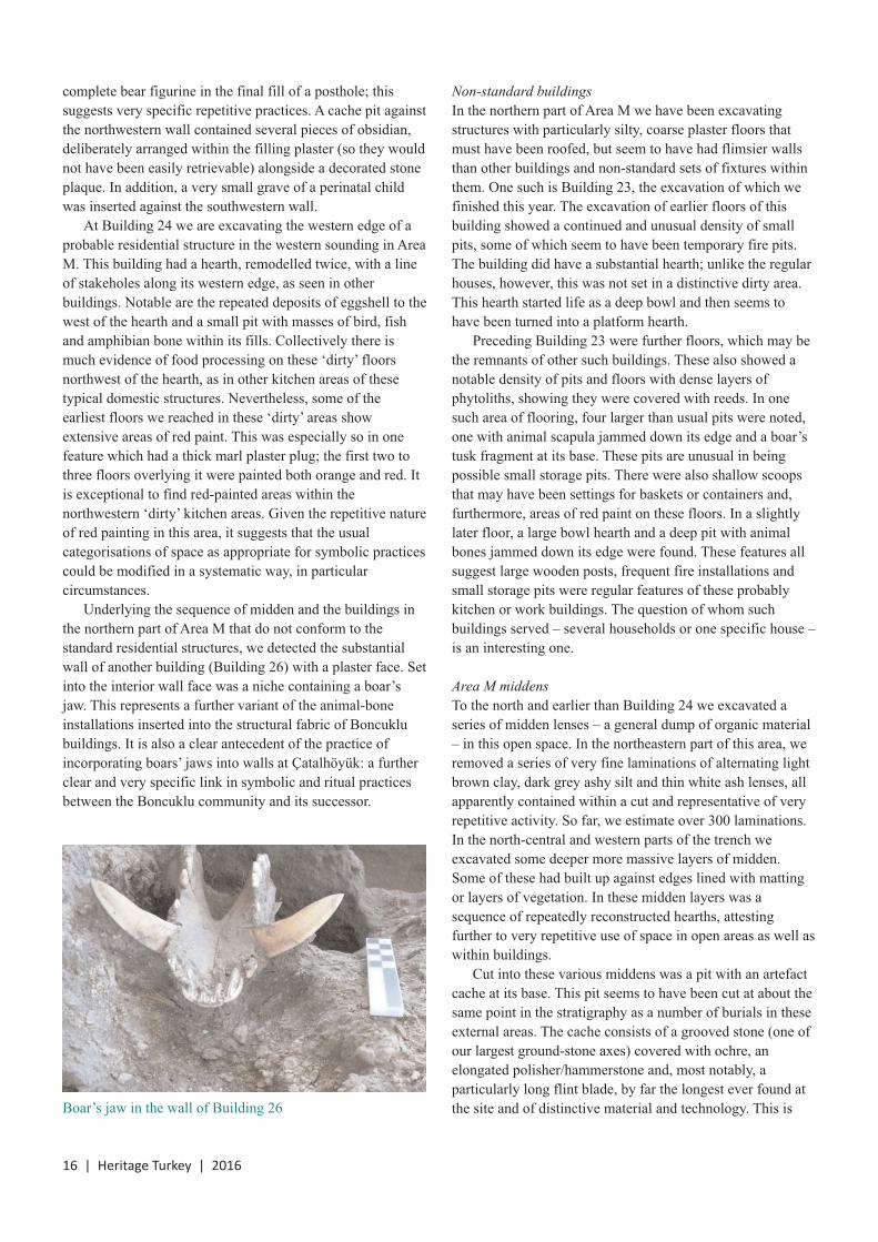
Underlying the sequence of midden and the buildings inthe northern part of Area M that do not conform to thestandard residential structures, we detected the substantialwall of another building (Building 26) with a plaster face. Setinto the interior wall face was a niche containing a boar’sjaw. This represents a further variant of the animal-boneinstallations inserted into the structural fabric of Boncuklubuildings. It is also a clear antecedent of the practice ofincorporating boars’ jaws into walls at Çatalhöyük: a furtherclear and very specific link in symbolic and ritual practicesbetween the Boncuklu community and its successor.
Non-standard buildingsIn the northern part of Area M we have been excavatingstructures with particularly silty, coarse plaster floors thatmust have been roofed, but seem to have had flimsier wallsthan other buildings and non-standard sets of fixtures withinthem. One such is Building 23, the excavation of which wefinished this year. The excavation of earlier floors of thisbuilding showed a continued and unusual density of smallpits, some of which seem to have been temporary fire pits.The building did have a substantial hearth; unlike the regularhouses, however, this was not set in a distinctive dirty area.This hearth started life as a deep bowl and then seems tohave been turned into a platform hearth.
Preceding Building 23 were further floors, which may bethe remnants of other such buildings. These also showed anotable density of pits and floors with dense layers ofphytoliths, showing they were covered with reeds. In onesuch area of flooring, four larger than usual pits were noted,one with animal scapula jammed down its edge and a boar’stusk fragment at its base. These pits are unusual in beingpossible small storage pits. There were also shallow scoopsthat may have been settings for baskets or containers and,furthermore, areas of red paint on these floors. In a slightlylater floor, a large bowl hearth and a deep pit with animalbones jammed down its edge were found. These features allsuggest large wooden posts, frequent fire installations andsmall storage pits were regular features of these probablykitchen or work buildings. The question of whom suchbuildings served – several households or one specific house –is an interesting one.
Area M middensTo the north and earlier than Building 24 we excavated aseries of midden lenses – a general dump of organic material– in this open space. In the northeastern part of this area, weremoved a series of very fine laminations of alternating lightbrown clay, dark grey ashy silt and thin white ash lenses, allapparently contained within a cut and representative of veryrepetitive activity. So far, we estimate over 300 laminations.In the north-central and western parts of the trench weexcavated some deeper more massive layers of midden.Some of these had built up against edges lined with mattingor layers of vegetation. In these midden layers was asequence of repeatedly reconstructed hearths, attestingfurther to very repetitive use of space in open areas as well aswithin buildings.
Cut into these various middens was a pit with an artefactcache at its base. This pit seems to have been cut at about thesame point in the stratigraphy as a number of burials in theseexternal areas. The cache consists of a grooved stone (one ofour largest ground-stone axes) covered with ochre, anelongated polisher/hammerstone and, most notably, aparticularly long flint blade, by far the longest ever found atthe site and of distinctive material and technology. This isBoar’s jaw in the wall of Building 26

2016 | Heritage Turkey | 17
clearly a specialist product and an import to the site. So thiscache certainly included three exceptionally sized objects.They were all placed on a piece of bone. It is not impossiblethat this pit is one end of a burial or that it marks specialdepositions near and associated with burials; moreinvestigation will be required to ascertain which is the case.This further indicates that these open areas in the centre ofthe site were settings for symbolic practice as well as moremundane activities and rubbish disposal.
Experimental archaeologyGökhan Mustafaoğlu oversaw our experimental activities.
A cracking time. We have been challenged to understand thecomposition and nature of the plasters on the floors and wallsof the Boncuklu houses. Previous experiments trying toreplicate plasters with low quantities of temper (as appears tobe the case with the prehistoric plasters) failed dramatically.The first floors we laid in the new experimental houses in2014 cracked to a significant degree. Local mudbrick expertsrecommended the inclusion of high levels of straw temper,which duly ensured the floors held together. Since then wehave puzzled over the nature of the materials used and theirapplication.
Micromorphological study by Wendy Matthews and AroaGarcia-Suarez has demonstrated some organic content in thefloors, including rare dung and, especially, some burntorganics and some sand. As a result, we decided toexperiment with a range of more appropriate materials,mixes and application conditions to see if we could producefloor plasters more akin to those used in the Neolithic for ournext major refurbishment of the interiors of the buildings.
The local white marl was the major constituent of all themixes. We added to this three different categories of material:quartz, burnt organic and unburnt organic temper. A controlset of samples consisted of just marl and the lower alluvial
sediment. All the other experimental mixes included thequartz, and various mixes of the burnt organic and unburntorganic were incorporated with the marl, lower alluvium andquartz. Including the controls, this resulted in 16permutations, many of which we felt were similar to theprehistoric plaster mixes. Unfortunately, all the experimentalfloor patches cracked, except the two samples which hadvery high elements of organic inclusions: one with very highproportions of wetland vegetation and one with highquantities of fresh animal dung. These thus bore similaritiesto the more recent ethnohistorical floors but not to theNeolithic floors.
Area M artefact cache
Experimental floor plasters
The issue of the plaster recipe thus remains a conundrumand we suspect that the judicious choice of marl and otherclay mixes, with the right shrinkage characteristics, wouldproduce the desired result, but we are unsure of relevantsources in the landscape. We look forward to tracking downthese materials in future years and producing just the rightplaster mix.
Grave slumping. Observing the outcomes of last year’sexperimental work was instructive. At the beginning of theseason we were surprised to note that the graves we placed inthe experimental houses showed no sign of slumping, incontrast to the Neolithic examples which always show thisphenomenon. We speculated that this might be due toinsufficient use of the overlying floor area. As a result, weincreased the traffic and weight applied at regular intervalsduring the season. This eventually had the desired effect inhouse 2, where significant slumping was observed. Otherfactors involved may have been the backfilling of theNeolithic graves with a more mixed midden deposit than thealluvium excavated from and used to backfill theexperimental examples. This does suggest though that theprehistoric examples probably took some time to slump andthen only after significant traffic on the overlying floor.
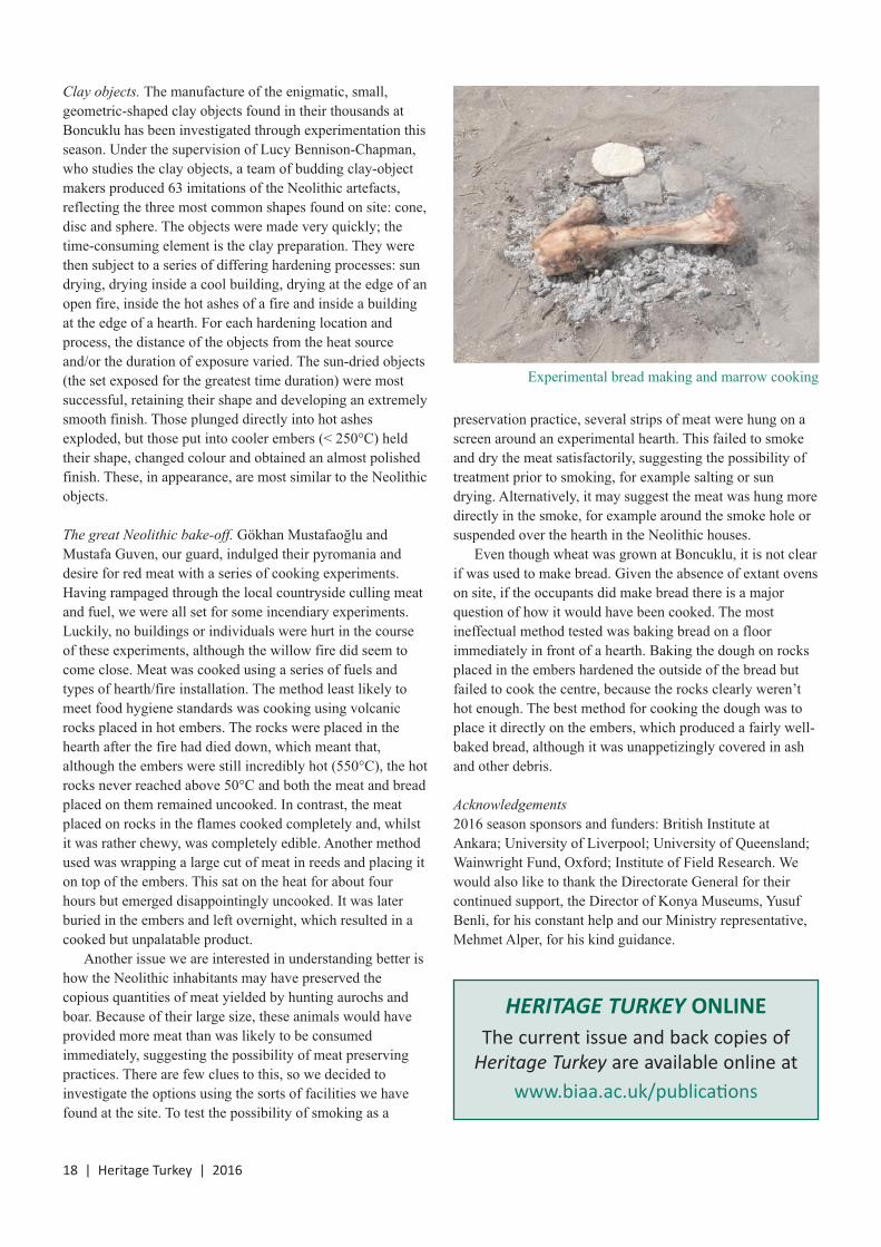
18 | Heritage Turkey | 2016
Clay objects. The manufacture of the enigmatic, small,geometric-shaped clay objects found in their thousands atBoncuklu has been investigated through experimentation thisseason. Under the supervision of Lucy Bennison-Chapman,who studies the clay objects, a team of budding clay-objectmakers produced 63 imitations of the Neolithic artefacts,reflecting the three most common shapes found on site: cone,disc and sphere. The objects were made very quickly; thetime-consuming element is the clay preparation. They werethen subject to a series of differing hardening processes: sundrying, drying inside a cool building, drying at the edge of anopen fire, inside the hot ashes of a fire and inside a buildingat the edge of a hearth. For each hardening location andprocess, the distance of the objects from the heat sourceand/or the duration of exposure varied. The sun-dried objects(the set exposed for the greatest time duration) were mostsuccessful, retaining their shape and developing an extremelysmooth finish. Those plunged directly into hot ashesexploded, but those put into cooler embers (< 250°C) heldtheir shape, changed colour and obtained an almost polishedfinish. These, in appearance, are most similar to the Neolithicobjects.
The great Neolithic bake-off. Gökhan Mustafaoğlu andMustafa Guven, our guard, indulged their pyromania anddesire for red meat with a series of cooking experiments.Having rampaged through the local countryside culling meatand fuel, we were all set for some incendiary experiments.Luckily, no buildings or individuals were hurt in the courseof these experiments, although the willow fire did seem tocome close. Meat was cooked using a series of fuels andtypes of hearth/fire installation. The method least likely tomeet food hygiene standards was cooking using volcanicrocks placed in hot embers. The rocks were placed in thehearth after the fire had died down, which meant that,although the embers were still incredibly hot (550°C), the hotrocks never reached above 50°C and both the meat and breadplaced on them remained uncooked. In contrast, the meatplaced on rocks in the flames cooked completely and, whilstit was rather chewy, was completely edible. Another methodused was wrapping a large cut of meat in reeds and placing iton top of the embers. This sat on the heat for about fourhours but emerged disappointingly uncooked. It was laterburied in the embers and left overnight, which resulted in acooked but unpalatable product.
Another issue we are interested in understanding better ishow the Neolithic inhabitants may have preserved thecopious quantities of meat yielded by hunting aurochs andboar. Because of their large size, these animals would haveprovided more meat than was likely to be consumedimmediately, suggesting the possibility of meat preservingpractices. There are few clues to this, so we decided toinvestigate the options using the sorts of facilities we havefound at the site. To test the possibility of smoking as a
preservation practice, several strips of meat were hung on ascreen around an experimental hearth. This failed to smokeand dry the meat satisfactorily, suggesting the possibility oftreatment prior to smoking, for example salting or sundrying. Alternatively, it may suggest the meat was hung moredirectly in the smoke, for example around the smoke hole orsuspended over the hearth in the Neolithic houses.
Even though wheat was grown at Boncuklu, it is not clearif was used to make bread. Given the absence of extant ovenson site, if the occupants did make bread there is a majorquestion of how it would have been cooked. The mostineffectual method tested was baking bread on a floorimmediately in front of a hearth. Baking the dough on rocksplaced in the embers hardened the outside of the bread butfailed to cook the centre, because the rocks clearly weren’thot enough. The best method for cooking the dough was toplace it directly on the embers, which produced a fairly well-baked bread, although it was unappetizingly covered in ashand other debris.
Acknowledgements2016 season sponsors and funders: British Institute atAnkara; University of Liverpool; University of Queensland;Wainwright Fund, Oxford; Institute of Field Research. Wewould also like to thank the Directorate General for theircontinued support, the Director of Konya Museums, YusufBenli, for his constant help and our Ministry representative,Mehmet Alper, for his kind guidance.
Experimental bread making and marrow cooking
HERITAGE TURKEY ONLINE The current issue and back copies of
Heritage Turkey are available online atwww.biaa.ac.uk/publications

Ups and downs at Çatalhöyük 2016
Ian Hodder | Stanford Universitydoi:10.18866/biaa2016.028
The site of Çatalhöyük consists of two mounds near Çumra, Konya in central Anatolia. The main East Mound has over 18levels of Neolithic occupation dated from 7100 to 5900 BC, while the West Mound has Chalcolithic levels. The site is one ofthe largest Neolithic sites in the Middle East and is a well-preserved example of the mega-sites that emerged in the later pre-pottery and pottery Neolithic. The site was established as being of international significance by the work of James Mellaart inthe 1960s and a new team has been working there since 1993, resulting in the site being placed on the UNESCO WorldHeritage List in 2012.
Since 1993 we have worked at the site for two to three months every summer, although in 1999 we excavated for sixmonths in order to dig a deep sounding to the base of the East Mound. However, when we reached the lowest levels ofoccupation in 1999 we found ourselves not in houses but in areas of midden and animal pens. So we still did not know whatthe earliest houses at Çatalhöyük might look like. Given the new work being carried out by Douglas Baird at nearby Boncuklu(see pages 15–18), which shows the existence of oval houses in the millennia prior to Çatalhöyük, it seemed important to tryagain to reach the base of the mound in the hope of glimpsing the earliest phase of housing. And so for 2016 we planned a five-month season with a core team of 12 excavators and 15 lab and support staff. We started on 1 May and all was going well untilthe civil unrest in Turkey in mid July that led to heightened concern amongst our research partners and amongst the team. Itherefore decided to end the season after only three months, with the aim of completing the planned excavation in 2017.
Despite the shortened season, we made some spectacular finds and learned much that is new about the site and itsdevelopment through time. Perhaps of greatest interest to the media was the discovery of two remarkably preserved stonefigurines. During July the core team had been joined by other researchers including a team from Poznan, Poland, led by ArekMarciniak. This team is now working in the TPC Area that links the South Area to the TP Area and the levels excavated byMellaart at the top of the East Mound. These upper layers are distinctive in many ways, but one of the most intriguing is theprevalence of female figurines with the ‘three Bs’ prominent – bellies, buttocks and breasts. In 2016 two remarkable stoneexamples were found in Building 150 (see another headless example found in 2015 in this building and reported on inHeritage Turkey 2015). The first figurine was found next to the eastern wall of Building 150 and right by the northern edgeof a burial. Its deposition is most likely associated with the construction of a platform. It seems to have been deliberatelyplaced on the surface of an earlier platformand then covered by the new platform. Thefigurine is made of marble and wasdeposited with a portion of an obsidianblade. A few days later a second, smallerfigurine was found deposited just to thenorth of the larger one; it is made oflimestone and was placed inside a lump ofmarl. Near the head of this second figurine apiece of galena was found, shiny andreflective like a mirror, and also two bluebeads. There are two perforations in thehead as if the object was suspended onstring.
These depositions were undoubtedly veryintentional and significant. The pairing oflocation and the fact that both were depositedwith obsidian or galena is highly unusual. Inthese uppermost levels of the site (Building150 is in a level equivalent to Mellaart’sLevel III), burial beneath platforms is lesscommon than in the earlier levels and oneintriguing suggestion is that these depositsreplaced inhumations. What is certain is thatthe depositions indicate the importance ofclosing and rebuilding platforms.
2016 | Heritage Turkey | 19
Left: first figurine foundin Building 150 by theTPC team led by ArekMarciniak. Above:second figurine found inBuilding 150. Thefigurines are shown atthe same scale. Allphotos in this article areby Jason Quinlan

20 | Heritage Turkey | 2016
AcknowledgementsThe main sponsors of the project in 2016 are Yapı Kredi,Boeing and Koçtaş. Other sponsors are Shell and ÇumraŞeker Fabrikası. Funding was also received from theTempleton Foundation, the British Institute at Ankara,Imitatio (Thiel Foundation), the Polish Academy ofSciences, SUNY Buffalo, Stanford University andArchaeology Center. We are, as ever, grateful for the supportof Ömer Koç. Our deep gratitude is due to the TurkishMinistry of Culture and Tourism and to our 2016 temsilciBünyamin, as well as to Konya Museums and its Director,Yusuf Benli.
Much of the media immediately latched onto thesefigurines as examples of the famous Çatalhöyük ‘MotherGoddess’. However, research on such figurines and their claycounterparts at the site by Lynn Meskell, Carrie Nakamuraand Lindsay Der has demonstrated that the focus on the‘three Bs’ at the site normally coincides with an emphasis onolder, mature women, in which the three Bs are oftensagging. Rather than mother goddesses, these images seem torepresent older women who have gained status and prestigein the community through their lifetimes.
Next to the ‘up’ trenches of the TPC Area where thesefigurines were found, one descends ‘down’ to the deepexcavations of the South Area. It is here that we are planningto get to the bottom of the East Mound in 2017. Inpreparation for that campaign, in 2016 we excavatedBuilding 17 and its neighbour Building 160 with 161 below.I mentioned the large number of burials below Building 17 inHeritage Turkey 2015. In 2016 the burials just kept oncoming until the whole floor began to look like a Swisscheese. As noted last year, many of these burials seem to becut into midden, but it is the sheer number of burials that ismost impressive. It is telling that Building 17 is the base of asequence of elaborate buildings that Mellaart called ‘Shrine10’. In the buildings above Building 17 we excavated largenumbers of burials in the 1990s, as did Mellaart in ‘ShrineVI.10’ in the 1960s. While we now accept that such buildingsare domestic, it is clear that some buildings (‘history houses’)are important for burial and ritual over the long term. Thiswas always a central house for burial.
Just to its east, however, is a stack of smaller buildings inwhich there are never many burials. Mellaart found a pair ofleopards on the western wall of the main room of thisbuilding, and we have continued to excavate the structure asBuildings 43, 160 and 161, going downwards in the stack. Inthe earliest level so far excavated, Building 161 has somecharacteristics that suggest it was paired with Building 17. Inparticular, both have ovens in highly unusual locations – thenortheastern corner of the main room – and in both there is acurved wall separating off the northern part of the room. Alsosignificant is that in both we found burials in which the torsohad been covered with rodent scat, and in both there areburials with planks. This pairing of buildings in the earlylevels of occupation has been seen in the construction ofMellaart’s Shrines 1 and 8 on the same raft, and in the verydistinctive pairing of his Shrines 14 and 7 in Level VI. Thepairing is presumably part of the larger focus on theinterconnection between houses in the lower levels ofoccupation.
In the North Area of the site we concentrated on continuingthe excavations in the large Building 132 that I described inHeritage Turkey last year. We also started excavating anadjacent midden area. For the first time we excavated this as ifit was a Palaeolithic cave, trying to tease apart the fine layersone by one, and plotting the position of all artefacts within a
1m grid. This proved an invaluable exercise, as we were ableto discern activity areas, hearths and work surfaces. Thisresearch is allowing us to understand for the first time howthese open areas (a better term than ‘midden’) functioned.
Excavations also continued in the very burned Building131, where many burials have been found with well-preserved organic material including wooden bowls. Next toBuilding 131 is the earlier Building 5. This had beenexcavated in the 1990s but we had not excavated the floors,wanting to leave the building on display. In 2016 we decidedto see if there were any burials beneath the floors, especiallyas the building above, Building 1, had contained over 62burials. And, indeed, below the northwestern platform aremarkably rich set of secondary burials was discovered.Burial F.3808 turned out to be the richest burial we have everfound at the site. In the upper part of the grave was a bundleof bones including a spinal column and a femur, all wrappedin a plant-based material. Below this bundle was a cinnabar-painted skull, placed inside a wood and basket container. Twoflint daggers and a shell were also placed inside the container.Outside the container were four of the highest qualitybifacially flaked obsidian points that I have ever seen, pressedinto some fibrous material, and a ‘macehead’ of white marble,beautifully and skillfully decorated in spiral meanders.
Burial F.3808 showing skull in container with flint blades, aswell as obsidian points, shell and macehead

Engaging the material and academic legacies of the first
BIAA-led surveys in the Konya plain
Christoph Bachhuber & Michele Massa | University of Oxford & Bilecik Universitydoi:10.18866/biaa2016.029
The Konya plain has been a major focus of research for theBritish Institute at Ankara since its founding in 1948, includingsurvey projects led by James Mellaart, David French, Ian Toddand Douglas Baird, and excavations at Canhasan, Pınarbaşı,Boncuklu and Çatalhöyük. It is from this legacy that our ownproject, entitled the ‘Konya Regional Archaeological SurveyProject’ (KRASP), was initiated in 2016.
Two outcomes of this earlier research are foregrounded inKRASP. On the one hand, there has been no attempt tointegrate all this BIAA legacy data into a regional analysis ofthe Konya plain and, on the other, the surveys have resulted inthe excavation of Neolithic and Chalcolithic settlements to thegeneral exclusion of all later periods. These interests reflect abroader trend in the archaeology of the Konya plain.Archaeologists have a far better understanding of the origins ofsedentism and agriculture in this region than of later historicaldevelopments. For example, although Bronze Age settlementswere a priority in the first BIAA-led surveys (see below), it issurprising that this period has subsequently attracted so littleinterest not only from BIAA-based scholars but from thearchaeological community as a whole. This is even moresurprising considering the Konya plain’s close proximity to thecore area of the Hittite state and the general popularity of theHittites in both academic and popular imaginations alike. Herewe would like to pick up where Mellaart, in particular, left offin his surveys of the Konya plain.
These first surveys are a study in contrasting academictemperaments. Mellaart believed that his survey-basedresearch could address one of the most puzzling questions forOld World archaeologists in the 20th century: the origins andspread of Indo-European speakers. French was more cautious,growing increasingly sceptical of the analytical potential ofprehistoric archaeology. He eventually abandoned prehistoricsurveys in favour of his ‘Roman Roads’ survey project. ForFrench, the certainties of Latin epigraphy inscribed on milemarkers were preferable to the vagaries of prehistoricsettlement patterns. Thus the dominant legacy of these earliestBIAA-led prehistoric surveys would become Mellaart’s, whocontinued to publish his ideas on Indo-Europeans (specifically‘the Luwians’) well into the 1980s. KRASP has inherited thedata of these first surveys but also, more problematically,Mellaart’s interpretations. The material legacy includes about6,000 sherds and 400 lithics collected from over 100Neolithic, Chalcolithic, Bronze Age and Iron Age settlementmound sites, all stored at the Institute in Ankara.
Mellaart developed a working hypothesis in his survey ofthe Konya plain during a period when most survey projectswere undertaken for the sole purpose of compiling site
gazetteers. As with so many other aspects of his career,Mellaart’s analytical abilities and archaeological imaginationwere more expansive than those of his peers. His hypothesisof an Indo-European invasion was spatially oriented andinterested in changes in material culture through time. Hismost compelling observations (see below) do not relate to thesecond millennium when Indo-European speakers aretextually attested (for example the Hittites), but to the thirdmillennium (Early Bronze Age, hereafter EBA) when there isno epigraphic evidence for an Indo-European language. Sowhy did Mellaart focus on the EBA? Since text-basedresearch was better placed to write histories of Indo-Europeans in Anatolia, then Mellaart clearly believed that theprehistoric origins of Indo-Europeans should be his domain.
Mellaart’s understanding of the EBA in the Konya plainwas rooted in a cultural historical paradigm that was alreadyreaching its twilight when he published these ideas in the1960s. In this vision, the Konya plain was indeed a two-dimensional cartographic plain across which a monolithiccultural entity – the Luwians – invaded. For Mellaart, the firstIndo-European speakers entered Anatolia from the easternBalkans during the EBA. Mellaart observed this invasion in anumber of phenomena across the western and southernregions in particular. For example, Mellaart believed that theLuwians used a technologically innovative type ofwheelmade, red-slipped pottery, most well-known from Troybut observable across much of Anatolia in the mid to late thirdmillennium BC. The majority of the sites in the Konya plainappear to have been abandoned and/or destroyed at the sametime that this pottery was introduced, signalling a profoundsocio-political disruption caused by the invasion. Notably, hehighlighted a dramatic drop of settlement frequency in theKonya plain from 100+ EBA sites to eight in the MiddleBronze Age. Mellaart followed these two trends across thewhole western and southern length of Anatolia, from Troy,through the Konya plain and as far east as Cilicia.
There are several reasons to doubt this historical scenarioon empirical and theoretical grounds. For example,stratigraphic, chronological and typological studies of thered-slipped pottery in excavations near Eskişehir have since
2016 | Heritage Turkey | 21
Archaeological survey pioneers in Turkey: James Mellaart (left) and David French (right)

demonstrated a probable origin in this region. The red-slipped repertoire was gradually adopted towards the west(Troy) and towards the south and east (Konya plain toCilicia). Our regional analysis will provide morechronological, spatial and technological resolution to theproblem of the appearance of this pottery in the Konya plain,but our research will likely reveal the adoption of this potteryrather than evidence for a migration. Also, preliminaryresults of our analysis of second-millennium pottery (MiddleBronze Age and Late Bronze Age) has shed light on asignificantly higher number of Middle Bronze Age sites thanMellaart himself identified. The dramatic drop in sitefrequency appears to be a bias in his ability to distinguishdiagnostic pottery, rather than a real demographic trend.
There were other biases in these first surveys also.Mellaart and French surveyed the landscape from a car,limiting their site identification to highly visible settlementmounds. They covered vast survey tracts at the expense ofmissing dozens if not hundreds of less visible sites. One of theprimary aims of KRASP is to fill in these blanks in settlementpatterns through our own planned pedestrian surveys, throughremote-sensing methodologies using aerial and satelliteimagery, and through the collation of all previous survey andsettlement-based research in the Konya plain. In this we willbe building on the methodologies and data of Baird’s morerecent surveys in the Konya plain, including the detection of‘flat sites’ through intensive investigations of canal cuts.
If there are obvious limits to the settlement data of Mellaartand French, then the BIAA corpus is ideal for addressing otherregionally extensive phenomena. Mellaart and French werepioneers in using ceramics collected from regional surveys toreconstruct networks of communication and technologytransfer. In March 2017 we will begin a geo-chemical andpetrographic study of the BIAA ceramics to address relatedconcerns, although with technologies and methodologies thatwere not available to Mellaart and French. This researchshould provide a higher resolution to problems related to theproduction and exchange of pottery in the Konya plain indifferent historical contexts, for example during the EBA whenthe wheelmade red-slipped repertoire was adopted.
Many of the questions we are asking of the BIAA legacymaterial were not asked by Mellart or French. Archaeologicalpreservation and heritage in the Konya plain are majorconcerns of KRASP. Part of our literature review of surveyand settlement data includes reports on the state ofpreservation of archaeological sites. We have calculated thatroughly 70% of the sites that Mellaart and French identifiedin the Konya plain have since been impacted by a range ofmodern activities. These include (in order of frequency):levelling a settlement mound to create an agricultural field,building on and inhabiting settlement mounds, looting,constructing roads and irrigation channels, quarryingsettlement mounds for fertile soil (kerpic) and thesubmersion of settlement mounds in dam reservoirs.
In addition to these published accounts, KRASP hasinitiated a remote-sensing (satellite-based) survey whichincludes among its other aims the visualisation and spatialanalysis of destruction to archaeological sites. This trend canbe traced on a nearly decadal basis through legacy and serialsatellite imagery. Likewise, data generated by the BIAAsurveys in the 1950s and 1960s will provide higher resolutionto those archaeological landscapes that have since beenaffected or otherwise destroyed by development and looting.
Modern impacts on the archaeological landscape raise anethically and analytically complex challenge for our project.Ultimately, these research questions will requireethnographic methodologies as we strive to understand therelationships between the archaeological landscape of theKonya plain and the various stakeholders in these landscapestoday, including local communities, Turkish and non-Turkisharchaeologists, and other Turkish national interests.
Since Mellaart, there has been no compelling Bronze Agenarrative of the Konya plain to match, for example, theoverwhelming interest in the Neolithic of this region(inspired initially by Mellaart). A Bronze Age narrative isneeded, not least, to attract more research attention to andheritage interest in the relevant archaeology of the Konyaplain. Mellaart had a gift for spinning archaeological storiesthat captivated generations of would-be archaeologists andthe colleagues and students who worked with him.Archaeologists need similar (if more disciplined) skills todayas the boundaries between archaeological research, heritageand outreach become increasingly blurred. These newresearch agendas are partly a response to the acceleratingtrends of development and looting that continue to threatenarchaeological landscapes across the greater region. If theBronze Age archaeology of the Konya plain is to be salvagedfrom oblivion then it needs to be made significant, in theimaginations of academics and the public alike.
22 | Heritage Turkey | 2016
Google Earth imagery of Üçhöyük III Mezarlık (cemetery) inthe Konya plain; this was identified in Mellaart and French’ssurveys and has since been impacted by ploughing activities
(shaded areas indicate the probable extent of damage or loss)

2016 | Heritage Turkey | 23
The early stages of metallurgy and metal exchange in
northwestern Turkey
Michele Massa | Bilecik Universitydoi:10.18866/biaa2016.030
The project ‘From mines to graves: metallurgy and metalexchange in northwestern inland Anatolia, ca 3700–1500BCE’, the pilot study of which has been sponsored by aBritish Institute at Ankara Small Grant, aims to shed lightonto the mechanisms of metal production and exchangeduring the early stages of metallurgy in western Turkey. Itbuilds upon several decades of research indicating that,during the Chalcolithic and Bronze Age (ca 6000–1200 BC),the Anatolian highlands was one of the most importantmetallurgical centres in the Old World. This region not onlyprovided copper, lead, silver and gold to surrounding metal-lacking areas, but was also at the cutting edge ofmetalworking technologies. For the early historical period,some 23,000 Old Assyrian cuneiform tablets (ca 1950–1700BC) supply incredibly accurate textual accounts ofinterregional metal exchanges between central Anatolia andUpper Mesopotamia. There is, however, increasingarchaeological evidence that this trade network is only themature phase of a process which started during the mid tolate fourth millennium BC. Furthermore, textual sources arealmost entirely silent with regards to the infrastructure ofmetal production, as well as the extent and complexity oflocal and regional trade networks within Anatolia.
Thus, ‘From mines to graves’ intends to open a newperspective into archaeo-metallurgical research in Anatolia byattempting to reconstruct the different stages of the LateChalcolithic and Bronze Age metallurgical chaîne opératoire(i.e. extraction, refinement, object manufacture) at the regionallevel. It also aims to understand the mechanisms of theexchanges of finished products within local and regionalnetworks, and the diachronical changes thereof, byinvestigating the relationship between highland sites (close tomines and refinement facilities) and lowland sites (close tomajor trade routes). The project focuses on an area (theEskişehir, Afyon and Kütahya regions) that has witnesseddense archaeological research, is rich in metal deposits andevidence for pre-modern mining, and is intersected byimportant natural routes connecting the Aegean with thecentral Anatolian plateau (see figure). It targets a large dataset(ca 800 metal samples) from 14 sites with different occupationspans (covering ca 3700 to 1500 BC), thus allowing adiachronic perspective about continuity and change in the useof specific technologies, alloys and shapes, as well as theability to identify potential differences at the regional scale.
During the project’s first stage, functional andtechnological typologies of metal objects and metallurgicaltools will be employed to highlight differences inmanufacturing traditions both diachronically and betweensites. In order to understand alloying practices, chemical
composition analysis will be conducted via a portable x-rayfluorescence spectrometer (pXRF). In the following stages,microscopic analysis (with SEM) and destructive chemicalanalysis (with ICP-MS) of slag and ore will allow a moredetailed insight into metallurgical technologies (for examplefiring conditions, additives and trace elements). Lead isotopeanalysis will target selected ore, slag and objects to sketchthe possible origins of raw materials and artefacts. Finally,an archaeo-metallurgical survey will explore known andpotential pre-modern mining sites, providing data on thescale and level of organisation of metal extraction indifferent periods.
Preliminary results indicate that all analysed settlements(starting at ca 3700–3500 BC) have evidence for in-site metalproduction in the form of tools and/or manufacturing debris,witnessing the widespread availability of raw materials in theregion. This is confirmed by earlier research that has identifiednumerous metal deposits in the region, as well as at least twoBronze Age mines. Analysis of slag and ore from two sitesalso hints at the presence of two more Early Bronze Agemines within the study area (at Emet 3 and Bakır Tepe, seefigure). Second, based on the available evidence, productsmade with sophisticated manufacturing techniques (forexample bivalve casting, lost-wax technique, metal plating)and more specialised metallurgical workshops seem to occurexclusively in lowland sites with easier access to exchangenetworks. On the other hand, excavated metal workshopswithin highland sites are characterised by small-scale and low-level specialisation activities, suggesting metal extraction andproduction from local sources and probably limited to localconsumption. Third, bronze objects (partly composed of tin, ararer metal) seem restricted to lowland sites with direct accessto interregional routes, a situation that only changes at thevery end of the third millennium BC when tin becomes morereadily accessible. This phenomenon is likely correlated withintensified relations with areas further to the southeast,approximately at the time of the establishment of the Assyriantrade network that introduced significant amounts of tin, likelyfrom Afghanistan and beyond.
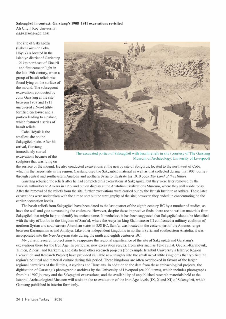
Sakçagözü in context: Garstang’s 1908–1911 excavations revisited
Ali Çifçi | Koç Universitydoi:10.18866/biaa2016.031
The site of Sakçagözü(Sakçe Gözü or CobaHöyük) is located in theIslahiye district of Gaziantep– 21km northeast of Zincirli– and first came to light inthe late 19th century, when agroup of basalt reliefs wasfound lying on the surface ofthe mound. The subsequentexcavations conducted byJohn Garstang at the sitebetween 1908 and 1911uncovered a Neo-Hittitefortified enclosure and aportico leading to a palace,which featured a series ofbasalt reliefs.
Coba Hoyuk is thesmallest site on theSakçagözü plain. After hisarrival, Garstangimmediately startedexcavations because of thesculpture that was lying onthe surface of the mound. He also conducted excavations at the nearby site of Songurus, located to the northwest of Coba,which is the largest site in the region. Garstang used the Sakçagözü material as well as that collected during his 1907 journeythrough central and southeastern Anatolia and northern Syria to illustrate his 1910 book The Land of the Hittites.
Garstang reburied the reliefs after he had completed his excavations at Sakçagözü, but they were later removed by theTurkish authorities to Ankara in 1939 and put on display at the Anatolian Civilizations Museum, where they still reside today.After the removal of the reliefs from the site, further excavations were carried out by the British Institute at Ankara. These laterexcavations were undertaken with the aim to sort out the stratigraphy of the site; however, they ended up concentrating on theearlier occupation levels.
The basalt reliefs from Sakçagözü have been dated to the last quarter of the eighth century BC by a number of studies, ashave the wall and gate surrounding the enclosure. However, despite these impressive finds, there are no written materials fromSakçagözü that might help to identify its ancient name. Nonetheless, it has been suggested that Sakçagözü should be identifiedwith the city of Lutibu in the kingdom of Sam’al, where the Assyrian king Shalmaneser III confronted a military coalition ofnorthern Syrian and southeastern Anatolian states in 858 BC. Sam’al was located in the eastern part of the Amanus rangebetween Karamanmaraş and Antakya. Like other independent kingdoms in northern Syria and southeastern Anatolia, it wasincorporated into the Neo-Assyrian state during the ninth and eighth centuries BC.
My current research project aims to reappraise the regional significance of the site of Sakçagözü and Garstang’sexcavations there for the Iron Age. In particular, new excavation results, from sites such as Tel-Tayinat, Gedikli-Karahoyuk,Tilmen, Zincirli and Karkemiş, and data from other research projects (for example Istanbul University’s Islahiye RegionExcavation and Research Project) have provided valuable new insights into the small neo-Hittite kingdoms that typified theregion’s political and material culture during this period. These kingdoms are often overlooked in favour of the largerregional narratives of the Hittites, Assyrians and Urartians. In addition to the data from these archaeological projects, thedigitisation of Garstang’s photographic archives by the University of Liverpool (ca 900 items), which includes photographsfrom his 1907 journey and the Sakçagözü excavations, and the availability of unpublished research materials held at theIstanbul Archaeological Museum will assist in the re-evaluation of the Iron Age levels (IX, X and XI) of Sakçagözü, whichGarstang published in interim form only.
24 | Heritage Turkey | 2016
The excavated portico of Sakçagözü with basalt reliefs in situ (courtesy of The GarstangMuseum of Archaeology, University of Liverpool)

2016 | Heritage Turkey | 25
Sinop Kale Excavations 2016
Jane Rempel & Sue Sherratt | University of SheffieldWith Owen Doonan, Andrew Goldman, Alexander Bauer, Emine Sökmen, Beth Watson & Holly Roseveardoi:10.18866/biaa2016.032
In the summer of 2016 the second season of the Sinop Kale Excavations project unfolded, with continued excavations in theheart of ancient Sinope, on the Black Sea coast of Turkey, as well as a programme of environmental sampling, study of thehandmade pottery and recording and virtual reconstruction of the Hellenistic fortification wall that runs across the neck of theSinop peninsula.
This project, directed by Owen Doonan (California State University Northridge), builds on more than a decade of survey andenvironmental research conducted by the Sinop Regional Archaeological Project. Its aim is to investigate the nature of pre-Greeksettlement as well as the early Greek settlement and its later development. The Sheffield contingent, supported by funding fromthe BIAA and including Jane Rempel and Sue Sherratt from the Department of Archaeology as well as recent graduate NickGroat and current undergraduates Holly Rosevear and Beth Watson, worked alongside an international team including AssociateDirector Alexander Bauer (Queens College, New York), Assistant Director Emine Sökmen (Hitit University), Field DirectorAndrew Goldman (Gonzaga University) and staff and students from both American and Turkish universities. Project funding, inaddition to that provided by the BIAA, comes from the National Geographic Society, the National Endowment for theHumanities, CSU Northridge, Queens College and Gonzaga University. This year, the University of Sheffield was also able tosupport our undergraduate students through the Sheffield Undergraduate Research Experience scheme (SURE). Through six-week paid placements, the SURE awards provide undergraduate students with the opportunity to work in partnership with anacademic staff member on a dedicated research project during the summer vacation. Through their SURE projects, studentsbecome directly involved in the research activity of the University, take part in active research projects in subject areas that areof special interest and experience what it is like to work in partnership with academic staff or collaboratively in a research group.
Beth Watson’s SURE project – ‘Understanding the Hellenistic fortification walls at ancient Sinope, Turkey’ – involvedworking with Jane Rempel to record and interpret the remains of the Hellenistic fortification wall in the Sinop Kale area. Thefortification walls of the Kale are a prominent feature of the town, both ancient and modern, and they represent the best-surviving Hellenistic fortifications in northern Asia Minor and the Black Sea region (Crow 2014: 38–39). Strabo, around thebeginning of the common era, called Sinope ‘the beautifully walled city’ (12.3.11). The Hellenistic wall that he describes ran asa curtain wall northwest to southeast across the neck of the Boztepe peninsula. This line of wall still survives today, albeit withlater Roman, Byzantine, Seljuk and Ottoman additions; the best-surviving section of the original Hellenistic wall is located atthe northwestern end, in the Sinop Kale Excavations project area. This includes the northwestern Hellenistic tower, with itsupper portions rebuilt, an adjoining section of the Hellenistic wall (also with upper portions rebuilt and restored), as well as asection of the foundations and lower courses of the Hellenistic wall that had been exposed by earlier archaeological work in thearea (see the 3D reconstruction, below).
While textual references attest to a fortification wall at Sinope at least as early as the early fourth century BC (PolyaenusStratagems 7.21), the earliest surviving wall is from the Hellenistic period and has been traditionally associated with one oftwo kings of Pontus: Pharnakes I (second century BC) or Mithridates VI (first century BC) (Bryer, Winfield 1985: 70, 76–77;Doonan 2004: 76; Crow 2014: 39).
The design of the Hellenistic fortification wall is unique, however. Although the isodomic masonry of quarry-faced blockswith drafted margins and the bevelled corners on its towers suggest a Hellenistic date, a series of arrow slots with projectinglintels is unparalleled (Crow in Bryer, Winfield 1985: 78; Crow 2014). In addition, stratigraphic excavations of the foundationtrench for the Hellenistic fortification wall in 2015 and 2016 have provided a close understanding of its construction processand preliminary reading of the material in itsfills suggests it is not later than the third centuryBC. The chronological resolution provided bythe Sinop Kale Excavations will provide animportant contribution to studies of fortificationwalls of this period as well as to ourunderstanding of the urban development ofancient Sinope.
A first attempt at a 3D model of the wall sectionin the Sinop Kale Excavations project area
(J. Rempel and A. Çobanoğlu)

26 | Heritage Turkey | 2016
In order to understand better the nature of the wall, it wasimportant to record the surviving remains in the project areaso that its construction and morphology can bereconstructed. Beth’s SURE project involved recording theexposed foundations of the Hellenistic fortification wallusing close-range photogrammetry. This technique uses alinked series of digital images to create measurement-accurate 3D models (like that above). Agisoft Photoscan wasused to process the images and MeshLab to ensure theaccuracy of scales applied to the models using knownmeasurements. This work has resulted in a spatially accuraterecord of the surviving architecture of the Hellenistic wall inthe Sinop Kale Excavations project area and the models willbe used to create 2D measured drawings in AutoCAD. Wewere also able to work with Ahmet Çobanoğlu to create a 3Dmodel of the entire northwestern corner of the survivingfortification wall, including the Hellenistic tower, fromimagery taken from an unmanned aerial vehicle, commonlyknown as a drone (see figure on previous page).
Holly Rosevear’s SURE project – ‘The handmadepottery of Sinop Kale’– involved working with SueSherratt. They made a start on studying some of thehandmade pottery found in the 2015 excavation,particularly that found in Locus 29. Locus 29 was originallythought to lie inside a ‘dugout’ (House 1) on the westernside of Operation 1 (Rempel et al. 2015; Doonan et al.2016), but excavation in 2016 revealed that the wall,consisting of eight or more courses of flattish stones andthought to define the northeastern edge of House 1, actuallyextends for at least 5m more to the southeast, suggestingthat Locus 29 probably lay (in a yard?) outside thestructure, the rest of which to the north and northeast waseventually destroyed or covered by the Byzantine wall. Thepottery from Locus 29 consists almost entirely of handmadepottery of varied appearance and with various types ofdecoration, some of which has a generally Early BronzeAge (third millennium BC) appearance. It also, however,bears resemblances to pottery uncovered in 2000 in aneroding scarp to the west of the 2015 excavation and at asomewhat lower level, associated with what weretentatively identified as stone-lined pit houses. These werestratified below the Hellenistic levels, and both architectureand pottery were compared to material from northern andwestern Black Sea sites of Early Iron Age (early first
millennium BC) date (Doonan 2004: 56–58). Only a coupleof wheelmade sherds, well embedded within Locus 29,hinted that some – or perhaps much – of this pottery mightactually be contemporary with an early stage of the Greekcolony of Sinope in the late seventh to sixth century BC. Amajor question was thus whether any of the pottery fromthe fill was genuinely of Early Bronze Age date (sodemonstrating Early Bronze Age occupation of the site) orwhether the indigenous inhabitants continued makingpottery of generally Early Bronze Age appearance after thefoundation of the colony at the end of the seventh centuryBC, and, if so, for how long. In other words, what the daterange of the pottery from the fill of Locus 29 is likely to be.Given the lack of understanding hitherto of the prehistoricceramic chronology of this part of the Turkish coast (whichhas in the past led to suggestions that it was uninhabited forlong stretches between the Early Bronze Age and theseventh to sixth century BC), this is a particularly importantissue. Another question is the extent to which similarities topottery from other sites around the Black Sea should beregarded as the result of maritime interaction, and, if so, atwhat points in time in particular.
In order to begin to investigate these questions, Hollystrewed, sorted and macroscopically examined all featuresherds (those with rims, bases, handles or decoration) fromLocus 29, and entered them in a database in which details offabric, inclusions, surface finishes, types of decoration, rimor base types (where appropriate) and possible shapes wererecorded. These entries are accompanied by a photograph ofeach sherd and supplemented by profile drawings of rimsand bases.
3D model of a portion of the Hellenistic wall (B. Watson and J. Rempel)
Holly Rosevear studying some of the handmade pottery(photo by Sue Sherratt)

Preliminary results suggest that Locus 29 contained aninteresting variety of fabrics and tempers, surface colours,surface finishes and decorations. Most sherds are relativelycoarse, but a few are of a notable fineness. Temperingincludes shell/calcareous inclusions, quartz pebbles and somechaff; cores are frequently black (a normal indication of lowfiring temperatures). Surface colours range from black togreyish yellow/buff to red, including some mottling. Surfacefinishes include varying degrees of burnish, sherds with arough concrete-like finish outside and a smoothed/burnishedinterior, and an unusual burnished red washy slip. Among theshapes (where determinable) are rounded and carinated bowlsor cups and jars of various sorts, including hole-mouthed jars;rims tend to be rounded or pointed and sometimes slightlysquared, bases can be flat or raised and handles vertical orhorizontal. Decorations include applied or pulled-up ridgeswith finger-impressions or diagonal slashing, knobs or lugs,neatly impressed holes and incised lines.
Despite its general ‘Early Bronze Age’ appearance, itseems unlikely that much, if any, of this pottery is actuallyEarly Bronze Age in date. On the other hand, some of itseems to find good parallels at sites, such as Berezan andOlbia, on the northern coast of the Black Sea, wherehandmade pottery co-exists with imported Greek potteryfrom the late seventh century down to the fifth century andlater. Particular similarities can be seen in several of theshapes, in the finger-impressed ridges, in the knobs and lugsand the rows of impressed holes (for example Solovyov1999: figs 18, 20–22; Gavriljuk 2010: pls 262–69), whilesome of the incised pottery seems reminiscent of some of theso-called Kizil-Koba pottery of the northern Black Sea(Solovyov 1999: fig. 24). Especially intriguing are one ortwo sherds on which differential burnishing appears to havebeen used to create a rim band of the sort one might see onimported painted pottery, which might suggest
contemporaneity with, and influence from, the latter. Theresults of portable x-ray fluorescence (pXRF) analysiscombined with microscopic studies of technologicalprocesses, carried out this summer by Alexander Bauer on anumber of the sherds, should help to establish groups ofwares based on different clay sources and give some idea ofthe variety and possibly varied sources of this pottery.
For a summary of the results of the 2015 season, seehttp://antiquity.ac.uk/projgall/578 and the Sinop KaleExcavations web site: http://srapexcavation.wixsite.com/kale.
ReferencesBryer, A., Winfield, D. 1985: The Byzantine Monuments and
Topography of the Pontos. Washington DC, DumbartonOaks
Crow, J. 2014: ‘Sinop, the citadel walls, description andcommentary’ in S. Redford (ed.), Legends of Authority:The 1215 Seljuk Inscriptions of Sinop Citadel, Turkey.Istanbul, Koç University Press: 21–60
Doonan, O. 2004: Sinop Landscapes: Exploring Connectionin a Black Sea Hinterland. Philadelphia, University ofPennsylvania Museum
Doonan, O. et al. 2016: ‘Sinope ancient Kale excavations2015: towards a new model of mobile fishing commu-nities and incipient trade in the Black Sea’ AntiquityProject Gallery: http://antiquity.ac.uk/projgall/578
Gavriljuk, N.A. 2010: ‘Handmade pottery’ in N.A.Lejpunskaja et al. (eds), The Lower City of Olbia(Sector NGS) in the 6th Century BC to the 4th CenturyAD. Aarhus, Aarhus University Press: 335–54
Rempel, J. et al. 2015: ‘Settlement, colonisation and BlackSea networks: Early Iron Age to Classical Sinope’Heritage Turkey 5: 30–31
Solovyov, S.L. 1999: Ancient Berezan. The Architecture,History and Culture of the First Greek Colony in theNorthern Black Sea. Leiden, Brill
2016 | Heritage Turkey | 27
University of Sheffield archaeology undergraduates HollyRosevear, Nick Groat and Beth Watson in front of theHellenistic fortification wall (photo by J. Rempel)
View from the Sinop Kale Excavations project area toAk Liman after a rainstorm (photo by J. Rempel)

28 | Heritage Turkey | 2016
New finds and new results at Aphrodisias in 2016
R.R.R. Smith | Oxford Universitydoi:10.18866/biaa2016.033
Aphrodisias has been excavated continuously since 1961under the aegis of New York University, and the siteilluminates brilliantly the life and art of ancient cities in theeastern Mediterranean, from Roman imperial times into thepost-classical world. The current project focuses on thedocumentation, conservation and publication of alreadyexcavated monuments and on targeted new excavation andresearch, aiming to understand better the character andhistory of the site from the Roman into the late antique,Byzantine and Ottoman periods.
In 2016, the Aphrodisias team worked a long season,from 1 June to 30 September. There were some 60 of us, bothstudents and colleagues – archaeologists, architects,conservators, epigraphists, restorers, surveyors,photographers, draftsmen and numismatists – together with96 local workers. There were important results andinteresting finds.
The South Agora and Tetrapylon StreetExcavation was concentrated on two longstanding projects –in the South Agora and on the Tetrapylon Street – both partsof a plan to create an enhanced visitor route through thecentre of the site, from the Sebasteion to the TetrapylonStreet to the South Agora.
The South Agora is dominated by a 170mpool, partly excavated in the 1980s. After adetailed survey of its water system in 2011 andtest trenches in 2012 that revealed plantingtrenches for palm trees around the pool, a five-year project was begun in 2013. This isgenerously funded by Mica Ertegün and calledThe Mica and Ahmet Ertegün South AgoraPool Project. The project is designed tocomplete the excavation of the pool and toresearch its long archaeo-history and that ofthe surrounding palm grove.
Excavation in 2016 investigated theoverlying medieval and post-medieval levels,as well as the plantings surrounding the pool.One large trench (SAg 16.1) was excavated inphase across the eastern half of the complexand reached below the marble seat courses ofthe pool’s inner perimeter. The marblesurround of the pool is now almost fullyexposed.
In addition to some important marble finds,perhaps the most striking aspect of theexcavation was the high level of post-antiqueand medieval activity across the whole area.Far from being empty fill, the levels above thepool have a complex sequence of walls andstrata from approximately the tenth through tothe 16th century, accompanied by significantdeposits of glass and metal slag. They imply alevel of human activity not previouslyexpected at the site in these periods.
View of Aphrodisias

2016 | Heritage Turkey | 29
Among an abundance of coins, small finds and marblefragments of architecture and statuary, two items may bementioned. A newly uncovered slab of the pool’s southernperimeter was found to be inscribed with a semi-publicgraffito, prefaced by a cross, for one ‘Kolotron, head gold-worker (protaurios), whom God shall remember’ (I 16.20). Thetext is accompanied by two engraved frontal busts of athletes:one (left) wearing an elaborate victor’s crown; the other a muchlarger bust (right) of a thick-necked boxer or wrestler. Thisathlete has a single lock of hair emerging from his otherwiseclean-shaven head – the hairstyle of the professional heavyathlete (cirrus in vertice). The same Kolotron is known from asimilar seat inscription in the Theatre.
A fragment of an early imperial portrait head (inv. 16-52)was excavated during the cutting back of the east section ofthe pool fill at the eastern limit of SAg 16.1, where the 1990excavation of the eastern end of the pool had stopped. Twodumps full of roof tile, pieces of wall revetment and smallfragments of carved marble were uncovered here, on thenorthern side of the pool. The head fragment was found inthe lower dump layer in what was probably an early seventh-century context. The head was once part of a high-qualityportrait statue of the Julio-Claudian period. Its nose, upperface and hair fringe are perfectly preserved. The quality ofthe portrait can be seen in the delicate carving of the line ofits upper teeth in the slightly opened mouth.
The Tetrapylon Street runs north to south from theTetrapylon to the Propylon of the Sebasteion. Its excavation,begun in 2008, is designed to open this part of the street forvisitors and to bring new information about the history of thesite in the late antique, Byzantine and Ottoman periods.
Excavation in 2016 concentrated on the deep overburdencovering the street immediately south of the Propylon of theSebasteion (SAve 16.1-3). The aim is to extend the streetexcavation to the south to connect it with the back of theAgora Gate at the original Roman level, both to enhancevisitor circulation at the site and to investigate a key urbanhub in the ancient city plan.
The South Agora pool
The newly uncovered graffito
The Tetrapylon Street

30 | Heritage Turkey | 2016
The eastern half of the excavation area was occupied byseveral subsequent street levels. At the eastern limit of thetrenches, the street had always been bordered by a sizeablewall. In origin, this was a Roman wall that defined thewestern line of a well-preserved complex known as theCryptoporticus House. In later periods, unmortared rubblewas added on top of the Roman wall remains, but it is clearfrom the excavation of several walls oriented east to westacross its line that for a long period after the seventh centurythis area was no longer used as a street.
The western half of the excavated area was occupied by asizeable, well-built structure (visible in the foreground of thephoto on the previous page). The excavation has so faruncovered its two most northern spaces, both of which hadbeen intentionally filled in, probably in the later 19th century.The eastern space was a water tank, lined with hydraulicmortar, supplied by a pipe coming from the south and heatedby a praefurnium on its eastern side. The larger western roomhad a hypocaust and water supply provided by a pipe fromthe tank that runs around the eastern and northern walls ofthe room. It was clearly the hot room of a small bathcomplex, of the middle to late Byzantine period. Since bathcomplexes of this period are rare, this excavated example isof considerable significance.
To the north of the Propylon, work aimed to excavatelarge brickfalls that had been left in situ on the Romanpavement in 2014 and 2015, in order to open the street and tocarry out conservation work on its paving. Three areas ofbrickfall that collapsed in the early seventh century from thewestern street wall were drawn, photographed and excavated(NAve 16.1). The southern brickfall lay directly on top of thestreet paving; the ‘middle’ brickfall came from two arches ofthe upper storey of the eastern street colonnade; and thenorthern brickfall lay on top of a thick layer of burned andunburned material, including window glass.
Part of this third context contained a large and importantfemale head (inv. 16-15). It is a veiled portrait of the earlyimperial period that clearly once belonged to the extensivestatue display on the Sebasteion’s Propylon. It has an idealAugustan physiognomy with the tight melon-hairstyle of ayoung woman. The trial attachment of the head to asurviving statue from the Propylon found nearby in 1981(inv. 81-151), although it does not join, showed that theyalmost certainly belong together. Furthermore, the statue isidentified independently, by its inscribed base (inv. 82-210),as Aemilia Lepida, wife of Drusus Caesar (son ofGermanicus). She appears prominently in history only in AD36 when she was forced to commit suicide, the Romanhistorian Tacitus tells us (Annals 6.40), because she wasconducting a widely known affair with a slave. Such matters,however, were not of much concern in Aphrodisias. Thenewly excavated head completes a remarkably well-documented honorific statue of a Tiberian princess, one whois not identified in any other portraits.
The Hadrianic Baths, Sebasteion and TetrapylonA major conservation project in the Hadrianic Baths, begunin 2010, was pursued for a final season with work on themain fabric of the complex. The Baths, partly excavated in1904–1905 and the 1960s, were in a bad state ofdeterioration. After seven years of work, the excavatedRooms 6, 7, 13 and 14 have now been conserved and openedto the public; Rooms 4, 5 and 12 have also been conservedand can be viewed from the exterior; and Room 15, the greatpalaestra court in front of the Baths, has been cleared andmade accessible to visitors.
In 2016, conservation work was concentrated in the greatcentral hot room of the complex, the caldarium (Room 4),and on the tall masonry support wall between Rooms 4 and5. A find of considerable historical significance was made inRoom 4: a well-preserved bronze coin of the emperor Phokas(AD 602–610) was recovered from the mortar layerimmediately beneath some loose marble paving. It impliesthat significant renovations were still being undertaken in theearly seventh century at a time when previously no such civicvitality had been suspected.
The physical anastylosis of the three-storeyed SouthBuilding of the Sebasteion is now mostly completed. In2016, work was carried out at the back of the structure,
The statue of Aemilia Lepida

2016 | Heritage Turkey | 31
building up the rear wall in petit-appareil-style masonry toact as a brace and support for the whole anastylosis. The firstphysical assembly of all parts of the Propylon’s first storey isalso now complete, and it was decided not to dowel and gluethe columns and entablatures permanently but to leave themdry-fixed as they are, in case further work proves possible.Important advances were made in 2016 in the study of theSebasteion’s building history. Careful cleaning and recordingrevealed that in late antiquity a water basin (9.25m wide) wasbuilt up against the front of the Sebasteion Temple at a timewhen it had been put out of use as a cult building.
The Tetrapylon, the grandiose entrance to the domain ofAphrodite, was the subject of an anastylosis project carriedout by Kenan Erim in the years 1983–1990. The anastylosisis checked and maintained periodically, and, in 2016, thewestern side of the structure was scaffolded, cleaned, pointedand thoroughly checked. Open joints and cracks betweenrepairs and the marble of the ancient building were mappedand filled using hydraulic lime-based mortars. Some of theabstractly restored figure and acanthus decoration of thepediment was remodelled and recoloured by hand to matchthe character of the surrounding stonework, using the KeimRestauro system.
Research and publicationResearch for publication remains a high priority, and in 2016publication study was pursued on the Stadium, Bouleuterion,North Agora, Byzantine architectural ornament and theRoman and Byzantine phases of the Temple of Aphrodite.
New Aphrodisias publications in 2016 include P. Stinson,Aphrodisias VII. The Civil Basilica and R.R.R. Smith, J.Lenaghan, A. Sokolicek and K. Welch (eds), AphrodisiasPapers 5: Excavation and Research at Aphrodisias, 2006–2012 (Journal of Roman Archaeology Supplement 103).Extensive work was carried out during the 2016 season insupport of three new monographs currently in press or infinal preparation: (1) N. de Chaisemartin and D.Theodorescu, Aphrodisias VIII. Le Theâtre d’Aphrodisias:les structures sceniques; (2) J. van Voorhis, Aphrodisias IX.The Sculptor’s Workshop; (3) E. Öğüş, Aphrodisias X. TheColumnar Sarcophagi.
AcknowledgementsThe Aphrodisias Excavations are sponsored by New YorkUniversity with invaluable support from foundations, privateindividuals and groups of friends – the Geyre Vakfı inIstanbul (President, Ömer M. Koç) and the Friends ofAphrodisias Trust in London (President, Lady PatriciaDaunt). The main foundations and individuals sponsoring theproject in 2016 were Mica Ertegün, the 1984 Foundation, theWorld Monuments Fund, the Headley Trust, the MalcolmHewitt Wiener Foundation, the Augustus Foundation, theLeon Levy Foundation, the Institute for Aegean Prehistory,the British Institute at Ankara, Oxford University’s CravenFund and the Shuffrey and Zilkha Funds of Lincoln College,Oxford. We express deep gratitude to the Turkish Ministry ofCulture and Tourism, to the Aphrodisias Museum and itsDirector, Yusuf Yılmaz, and to our government representativein 2016, Özgür Cavga from the Çannakale Museum.
The Hadrianic Baths
The South Building of the Sebasteion
The Propylon

32 | Heritage Turkey | 2016
Milled copper alloy plate and Neolithic stone object (photos by S. Moore)
A Roman woman from Çatalhöyük
Sophie Moore & Michelle Gamble | Brown University/University of Hull & Heritage andArchaeological Research Practice, Edinburghdoi:10.18866/biaa2016.034
Osteobiographies grant us an insight into the livesexperienced by people of the past. This year at Çatalhöyük,the historic cemeteries team was involved in excavating andstudying the remains of a Roman woman from Çatalhöyükwho had been interred with a remarkable assemblage ofobjects; the remains offered singular evidence of congenitaldisabilities. The process of piecing together the story ofhistoric Çatalhöyük is one which works at various scales; inprevious editions of Heritage Turkey we have discussed dataat the largest scale, focusing on the typology of graves andthe possible interactions between mortuary populations, herewe focus at the scale of a single human life.
Our Roman woman was buried in the cemetery thatoverlies the Neolithic remains at Çatalhöyük; this cemetery ispresent in almost every area excavated on site. She is part of amortuary group of approximately 62 graves dating from theRoman period, which have been determined as such by theirgrave goods, burial position and grave type. The 190 well-contextualised grave contexts from the first and secondmillennia AD comprise four morphological groups of graves.These groups correspond roughly to phases of cemetery use:Roman, Christian and two separate groups of Islamic-periodburials, all cut into the prehistoric East and West Mound tellsites. While the majority of historic-period burials contain fewgrave goods or inclusions, a number of the excavated Romanburials were richly furnished. The grave focused on here,Feature 5077, was cut into a Neolithic midden deposit close toa group of richly furnished burials excavated by the BACHteam (Cottica et al. 2012).
The woman is likely to have died in her mid-30s, and wasinterred in a Roman furnished burial, typical for the site: adeep, straight-sided grave aligned west to east with thecranium to the western end facing approximately east. The
pattern of decomposition of the body, particularly the openingof the pelvic girdle, indicates that the body decayed in a void(C. Knüsel, personal communication), while the presence ofwood and iron nails suggests the use of a coffin. Significantnumbers of grave goods and inclusions were recovered fromthe grave. Most came from within the line of the coffin orwere placed on the body itself. There are indications that thebody was loosely shrouded; the clavicles were held in avertical position and the right arm was held against the torso.In addition, red pigment staining the top of the spine (body ofT2) and left side of the mandible perhaps indicates that a red-coloured cloth, which stained the bone during decay, wasdraped over the cranium, in addition to a shroud wrapping therest of the body. The woman’s head is likely to have rested ona now decayed object at the time of deposition, elevating thetop of the cranium enough to allow it to face east.
Small finds from within the grave include a glassunguentarium recovered significantly above the level of theskeleton; this object might have been placed on the closedcoffin lid. A glass unguentarium with an oblong body wasrecovered from the left-hand side of the cranium and two goldearrings were closely associated with the left and righttemporal bones; these are likely to have been worn at themoment of burial. Two ceramic unguentaria were present.One was recovered unbroken from immediately behind thecranium, and was probably pushed against the western edgeof the coffin. The other was broken in half at the midline withthe base preserved, and came from the southern edge of thecoffin, closely associated with the right arm. A copper alloybox clasp, with associated fragmentary wood, was recoveredfrom the left of the body by the pelvis, and was found with afragmentary glass vessel, a worn fragment of bone pin and amilled rectangular copper alloy plate in the same area.Mineralised beneath the copper plate was a fragmentary sheetof wood and a small piece of coarse fabric. The latter could bepart of the shroud or, together, these items might be threeparts of a composite object. At the base of the grave two bluefaience melon beads were recovered, as well as a copper alloyear-scoop and a corroded iron fibula brooch.
In addition to the intentionally deposited items listedabove, the fill of the grave contained a significant quantity ofNeolithic objects. The inclusion of Neolithic objects inhistoric-period graves is not unusual at the site, particularly forgraves cut into midden contexts. It is likely that in most casesthe inclusion of Neolithic objects in historic-period graves isincidental, a by-product of the back-filling process. In somecases, however, such as feature 2403 on the West Moundwhere a very fine obsidian point was recovered in closeassociation with a burial, Neolithic objects may have beenintentionally buried with the Roman dead. One such object ispresent in this grave: a worked stone with rows of indentationssimilar to the markings on the copper alloy box hasp. The dateand nature of this decorated stone is unclear, making the natureof its inclusion in the grave assemblage ambiguous.

2016 | Heritage Turkey | 33
Although the small-finds assemblage from this grave isrelatively rich in comparison to most other Roman-periodgraves at the site, it contains a fairly standard suite of objectsfor an Anatolian furnished grave of the second or third
century AD, where cosmetic kits including vessels containingoil or perfume, ear-scoops and other small copper alloygrooming objects commonly accompany the burial ofwomen. The three glass vessels, two of which are largely
(i) gold earrings, (ii) copper alloy box hasp, (iii) milled copper alloy rectangular plate, (iv) wood preserved beneath iii, (v) fabricpreserved beneath iii, (vi) bone pin fragment, (vii) glass bottle neck, (viii) blue faience melon bead, (ix) blue faience melon bead,(x) copper alloy ear-scoop, (xi) iron fibula brooch, (xii) ceramic unguentarium base, (xiii) glass unguentarium, (xiv) glassunguentarium, (xv) ceramic unguentarium (i, xiii, xiv and xv illustrated by K. Killackey)

34 | Heritage Turkey | 2016
complete, provide a secure Roman date. Free-blown glassvessels, like these, date back to the Etruscan period andexamples are known from tombs as early as the second andfirst centuries BC, but they do not become common gravegoods until the first century AD, and the unguentaria formspresent here and in other previously published graves fromthe site are common for Anatolian graves of the first to thirdcentury. The vessel which may have been placed above thecoffin has most in common with a first-century type Isings28b, which continued in use into the second century with theaddition of a partially broken ring foot. The broken neck of athick-walled white vessel found at the base of the grave isperhaps more closely related to Isings 82b2, a form commonin the second and third centuries AD (Isings 1957).
The gold earrings and possibly the iron fibula broochare the only true grave goods, being distinct from graveinclusions in that they were worn by the deceased at themoment of burial. The two faience melon beads, whichshow close similarity to beads from a late Flavian mortuarycontext in Winchester (Biddle 1967: 243), may have beenworn during life, but are also likely to have apotropaicsignificance (Allason-Jones 1995: 27). The two beads fromthis grave are very worn around the bore, suggesting asignificant use-life prior to deposition. The wear on thebeads does not necessarily indicate their use as objects ofpersonal adornment; beads of this type have also been noteddecorating military equipment (Allason-Jones 1995: 27)and interpreted as having been used to decorate horseharnesses (Ritterling cited in Price, Worrell 2010). Beadsshowing little wear were perhaps produced specifically asfunerary objects and included in graves to ward off thespirits of the dead.
The woman herself had a number of congenital skeletalconditions which would have affected her during herlifetime. She was unusually small and gracile for thepopulation at large, with scoliosis to the right side, indicatedby the narrowing of her vertebral bones and the addition of apillar of bone anteriorly. There are associated changes to herpelvis, with the right auricular surface smaller than the left,suggesting asymmetric force transmission (C. Knüsel,personal communication). In life, this woman would havehad significant ambulatory problems, and her remains sitwithin a group of at least three other Roman skeletons,found in features 700, 706 and 1455, which displaysignificant palaeopathological changes which would havelimited mobility in life and necessitated care from others inthe community. A further seven individuals among theRoman burials show osteoarthritic changes or trauma to thefeet and legs.
As we enter our final year of fieldwork, and aim tocomplete the palaeopathological assessment of thecommunity in 2017, it will be interesting to establish whetherthe Roman population of this site contained an unusualnumber of people with conditions affecting their movement.
Another possibility of pathology is presented by a blackdeposit present at the base of the thoracic cavity, on theanterior surface of the ribs. This deposit is similar in terms ofcomposition and location as those noted on two adultskeletons from the Neolithic levels – sk.1378 in F.28 andsk.1424 in F.30 (Birch 2005) – and two adult burials from theRoman cemetery excavated by the BACH team – sk.2219and sk.2212 (Cottica et al 2012: 331–34). Wendy Birchsuggests that for the Neolithic individuals the deposit is aresult of pneumoconiosis, or ‘black lung’, caused by inhaledsoot, and it is possible that the woman buried in the Romangrave discussed here had the same condition. Conversely, theblack staining could be manganese deposited on the bonesduring the taphonomic process, and not an indicator ofpathology at all.
The aim of a full bio-cultural analysis of the individualsfrom the multi-phase historic cemetery at Çatalhöyük is toprovide a clearer understanding of both the individualsburied at the site and the communities of practice they livedwithin. Understanding the levels of pathology present in acommunity gives us insight at the scale of a population butalso allows us to look at the likely experiences of individualsand how they may have fitted into the broader picture. Forthe Roman community, one of the most interestingdeveloping threads of research is the frequent instances inwhich individuals who required a great deal of care duringlife were shown a great deal of respect in death. This was thecase for our Roman woman of limited mobility who wasburied with her gold earrings, iron brooch and scentedunguents. She was laid to rest carefully wrapped, dressed andprotected by two blue faience beads.
ReferencesAllason-Jones, L. 1995: ‘“Sexing” small finds’ in P. Rush
(ed.), Theoretical Roman Archaeology: SecondConference Proceedings. Aldershot, Avebury/Ashgate
Biddle, M. 1967: ‘Two Flavian burials from Grange RoadWinchester’ Antiquaries Journal 47: 224–50
Birch, W. 2005: ‘A possible case of shortness of breath atÇatalhöyük – black lungs’ in I. Hodder (ed.), InhabitingÇatalhöyük: Reports from the 1995–99 Seasons.London/Cambridge, British Institute at Ankara/Çatalhöyük Research Project: 593–96
Cottica, D., Hager, L.D., Boz, B. 2012: ‘Post-Neolithic useof Building 3 and Spaces 88 and 89 at Catalhoyuk’ in R.Tringham, M. Stevanović (eds), Last House on the Hill:Bach Area Reports from Catalhoyuk, Turkey. LosAngeles, Cotsen Institute of Archaeology: 331–43
Isings, C. 1957: Roman Glass from Dated Finds. Groningen,J.B. Wolters
Price, J., Worrell, S. 2010: ‘Roman glass’ in I. Ferris (ed.),The Beautiful Rooms are Empty: Excavations atBinchester Roman Fort, County Durham 1976–1981and 1986–1991. Durham, Durham County Council

2016 | Heritage Turkey | 35
Monumental architecture, cultural heritage management
and local perceptions of Aspendos
Lutgarde Vandeput & Işılay Gürsu | British Institute at Ankaradoi:10.18866/biaa2016.035
As in previous years, we joined the team working atAspendos under the direction of Veli Köse (HacettepeUniversity) to work on the monumental architecture(Vandeput) as well as on cultural heritage management andpublic archaeology (Gürsu).
Monumental architectureThe plan for the 2016 campaign at Aspendos was to carry outdetailed studies on the scaenae frons of the theatre and on thenymphaeum along the northern side of the agora; these aretwo important ‘eye-catchers’ situated along the newlydeveloped visitor routes at the site. However, 2016 has hardlybeen a ‘normal’ year for Turkey, and, as a result, the numberof tourists dropped drastically. This in turn resulted in limitedbudgets for Turkish excavation teams and forced the Aspendosteam to carry out a more limited programme than originallyplanned. Scaffolding did go up in front of the western half ofthe nymphaeum façade, but the project could not afford tofund scaffolding in the theatre. By way of an alternativeapproach to study of the scaenae frons, a series of systematicand detailed photographs was shot by drone; it remains to beseen, however, whether the necessary detail needed to producedetailed architectural drawings was obtained.
The erection of scaffolding in front of the façade of themonumental fountain was a necessity in order to conductresearch on the stability of the back wall of the fountain. Thisstands two storeys high, but reveals many cracks in itsmasonry, especially along its western edge. Like the theatre,
the supporting back wall of the aediculated façade of thenymphaeum still stands approximately to its full originalheight. It has survived so well since it is one of themonuments of ancient Aspendos that were reused by theSeljuks. The studies carried out by the team’s architectsduring the 2016 field season have laid the foundations for themajor project to consolidate the monument.
The presence of the scaffolding also allowed detailedstudy of the remaining in situ architectural decoration. Thenymphaeum is normally dated to the Antonine period on thebasis of this architectural decoration (Richard 2012: 258–80),which strongly resembles that of the theatre façade, as wellas on the date of the construction of the aqueduct (Grainger2009: 174). However, the building’s story turned out to berather more complicated than it seemed at first glance …
Research has revealed that the entablature seen todaywas not the original one. Preliminary studies had previouslyrevealed that the proportions of in situ building elementsfrom the aediculated façade were actually too small for theback wall of the building. This can best be observed at theside-wings where most of the building elements of theentablature are preserved. Whereas the lower edge of theprojecting frieze blocks of the architrave should normally bealigned with the back wall, here they sit at ca 0.5m in fromthe edge of this back wall. Furthermore, the top mouldingsof the cornice of the entablature barely jut out sidewaysfrom the back wall of the building. Detailed study of theremains has revealed that the back wall was cut back inareas in order to anchor the blocks of the currently preservedentablature. The socles for the projecting aediculae below,however, testify that the back wall supported an aediculatedfaçade from its inception. The cut-back spaces in the backwall could relate to the original façade or they could have
C U LT U R A L H E R I TA G E , S O C I E T Y & E C O N O M YThe promotion, management and regulation of cultural heritage is a complex process involvingmany different agents and stakeholders on local, national and international levels. It is a criticalelement of public policy involving a diverse range of actors such as international organisations,governmental ministries and agencies, political parties, private organisations, museums and localcommunities. How cultural heritage is produced and consumed, interpreted and understood canhave profound impacts on structuring social and economic interaction and decision‐making.Likewise, it influences the formation of social values and ideas as well as notions of commonidentity and history. It also affects economic and infrastructural development across a range ofdifferent levels. Cultural heritage management has become an important issue only recently inTurkey, and is now rapidly developing. As a result, a whole range of new issues and problems forwhich solutions have to be found within Turkey, but also on a much wider scale, have arisen. It isthese inter‐relationships contained within the field of cultural heritage that this StrategicResearch Initiative sets out to examine in the Turkish context.

36 | Heritage Turkey | 2016
been created to position the building elements of thecurrently preserved decorated entablature. To allow theselarge blocks to be manoeuvred and slotted into place, thewall was cut back in areas of the back wall that would beinvisible after the building blocks were positioned. The needfor space in order to manoeuvre the blocks may also explainthe presence of a row of undecorated limestone slabs belowthe frieze blocks of the architrave. With a corresponding rowof blocks above the cornices, they wedged the decoratedentablature securely against the back wall. Mortar andheavily mortared rubble were used to fill in gaps at alllevels. An alternative explanation is that the presentlypreserved entablature was simply too small for the pre-existing slots in the back wall and the additional rows oflimestone were needed to secure the smaller blocks of thecurrent entablature.
Hardly anything is preserved of the second storey of theaediculated façade, but a set-back in the back wall creates aledge above the top row of niches in the back wall. Thisseems to indicate that at one phase in the history of thismonument, a double-storeyed aediculated façade existed infront of the back wall. What happened to the blocks of theoriginal façade or when the original building was erected,remain unclear. Equally unclear is where the present-dayentablature originated from or at what point in time it wasinserted into the monumental back wall alongside the agora.
It is certain, however, that the building must have lookedmagnificent, with its projecting decorated façade and watercascading down into basins, via a waterfall emerging frombelow the central niche, and reflecting off the multi-colouredpolished marble revetment with which the back wall wasfully clad. Some of this revetment is still preserved in theniches of the upper storey. Even now, the monument remainsimpressive and awes its visitors. Architects working on the scaffolding erected in front of the
western half of the nymphaeum. The poorly insertedentablature as well as the large cracks in the wall show clearly
The entablature of the central niche, revealing the row ofundecorated limestone blocks wedged in underneath the
entablature and the conglomerate ashlars of the back wallpartially cut back to receive the entablature
A decorated architrave frieze block, revealing the limestoneblock on top of the cornice as well as the row of limestone
blocks below the architrave (forefront of photo). Themortared rubble connecting the decorated building elements
and the conglomerate back wall is also clearly visible

2016 | Heritage Turkey | 37
Cultural heritage management Running in parallel to these detailed architectural studies ofthe monuments lining the visitor routes, the cultural heritagemanagement project at Aspendos has continued; it focusedon four different activities in 2016. The first relates to thepeople-centred approach adopted by the project since itsinception. This year, Hakan Tarhan (postgraduate student,Boğaziçi University) and Işılay Gürsu (BIAA fellow) carriedout face-to-face interviews with the inhabitants of the nearbymarket town of Serik, one of the largest centres in theAntalya region. Sixty-five randomly selected people wereinvited to take part in this survey. The focus was mainly onfurthering an understanding of the attitudes of the localcommunity toward archaeological heritage, and, in particular,assessing their interest in the site of Aspendos. Theseinterviews built on work conducted in previous years in thesmall villages near Aspendos – Camili and Belkıs – as part ofan effort to understand better the role of Aspendos in theeconomic, social and cultural dynamics of thesecommunities.
by the Turkish Ministry of Culture and Tourism. During the2016 campaign, the locations of the orientation signs thatwill be placed across the site were finalised and some minorupdates were noted. The second phase of the AspendosLandscaping Project focuses on the development andimplementation of archaeological trekking and cyclingtrails connecting the site to its surroundings, especially tothe Eurymedon river. This should result in socio-economicbenefits for the local communities living around the ruinsof the site. Preparatory work for this second stage is on-going and will be completed within the next two months.This work is undertaken in consultation with EmrahKöşkeroğlu, the architect responsible for drawing up theplans, including walking paths along the river and throughthe villages.
A final activity concerns work on the presentation of thesite through new technologies. A specialist in 3Dreconstructions, Simon Young, joined the team in Aspendosthis year and conducted preliminary work on virtualreconstructions of specific monuments by means of OculusRift technology. He focused on the basilica in whichexcavations are currently taking place. Both thearchaeologists and the workmen were the first users of theOculus Rift glasses, which allow the wearer to experience afull virtual 3D reconstruction of the remains surroundingthem – a very exciting way to experience the site! Ways tomake this technology and these reconstructions available tothe public are being considered for the forthcoming seasons.
ReferencesGrainger, J.D. 2009: The Cities of Pamphylia. Oxford,
Oxbow Books Richard, J. 2012: Water for the City, Fountains for the
People. Monumental Fountains in the Roman East.Turnhout, Brepols
Işılay Gürsu interviewing a young shopkeeper in Serik
The second activity was another Children’s Day, whichwas organised at the explicit request of the children whoattended the same event last year. We provided anexcavation ‘pool’ in which some modern broken pottery hadbeen hidden by the team, and the children were encouragedto excavate and then restore the ceramics. They also had theopportunity to colour sketches of the Aspendosnymphaeum. An important aim of this event was to create‘memories’ related to the site in the minds of these childrenand to teach them about the importance of the site in anindirect way.
The third activity relates to both the first and the secondstages of the Aspendos Landscaping Project. The first stageentails the construction of a new visitor centre, the creationof new visitor routes within the site and the placement ofnew information boards; and this is soon to be implemented Children’s Day at Aspendos

The Pisidia Heritage Trail
Işılay Gürsu | British Institute at Ankaradoi:10.18866/biaa2016.036
The British Institute at Ankara’s cultural heritage managementproject sprung to life in 2013 and continues today. The maingoal of the project is to create awareness about thearchaeological heritage of Turkey, both among people who livein the vicinity of ancient ruins and potential tourists likely tovisit these sites. Cultural heritage is, of course, a finite andfragile resource and is under constant threat. Its protectioncannot be delegated simply to enforcing security measures vialaws and regulations. The sites which are the focus of thisproject are located far from densely populated settlements and,thus, are very vulnerable to illicit digging and decay due toneglect. Since they are not very well-known to the general public and therefore not visited frequently, they don’t receivesufficient government support to ensure their longevity. Their protection, therefore, must involve local communities and thefostering of a sense of pride in the sites. It is often the case that local communities become more willing to protect their localruins when they observe them being valued and visited by others.
One of the main elements of BIAA’s cultural heritage management project has been the creation of the Pisidia HeritageTrail (PHT), a long-distance trekking trail, more than 350km long, connecting ten different archaeological sites located in theancient region of Pisidia. These archaeological sites, situated in remote, pristine and densely forested highlands, have thepotential to offer a quasi-poetic experience for explorers. The route of the PHT follows the remnants of 2,000-year-old ancientroads and, where these ancient roads are no longer traceable, little paths that are still used by local villagers. The trail isdesigned to attract hikers, nature lovers and adventurers in general, and to provide economic benefits for the communities wholive in the vicinity of these ruins. This, in turn, is expected to result in increased protection of the sites by their localcommunities against illicit digging.
As a result of various periods of fieldwork undertaken in 2015 and 2016, the identification of the route has been finalised,with nine sub-routes connecting one archaeological site to another. The basic aim in plotting the route was to encompass themost pleasurable scenery and to arrange it in such a way that the little villages along the way could be easily visited from thetrail. The sub-routes are marked by an archaeological site at each end: (1) Trebenna to Termessos: 38.3km; (2) Termessos toAriassos: 33.7km; (3) Döşemeboğazı (ancient road) to Sia: 13.1km; (4a) Sia to Melli: 25.2km; (4b) Sia to Kocain Cave toMelli: 30.4km; (5) Melli to Pednelissos: 61.6km; (6) Pednelissos to Selge: 48km; (7) Melli to Kremna: 42.4km; (8) Kremna toSagalassos: 54.1km.
Establishing the trail itself and its promotion through different channels are in themselves effective ways of fosteringheritage protection. The project introduces an alternative tourism type to this highland region, where employment opportunitiesare limited, through management of this rich archaeological heritage. In the process of planning and implementing the trail,local people and authorities are being consultedat every step so that the project does not have atop-down approach, which may result in theexclusion of some parties. In addition to aformal meeting at the Ministry of Culture andTourism, to date, the Regional ConservationCouncil of Antalya, Burdur Museum, localadministrators of the villages along the route,national and local newspapers, the CultureRoutes Society, the Antalya Chamber ofCommerce and community leaders fromAntalya, as well as locals living in the villagesalong the trail have all been consulted.
The fieldwork and planning of the route,undertaken by a team of experts, was realisedthanks to the support of the Aurelius CharitableFoundation. The continuation of my fellowship
38 | Heritage Turkey | 2016
Pednelissos on the Pisidia Heritage Trail

2016 | Heritage Turkey | 39
for another two years was secured thanks to generousfunding from the Headley Trust. Additionally, the PisidiaAppeal, which was created last year, has attracted supportfrom both individuals and foundations, including RobertKiln, the Society of Dilettanti, the Stevenson Family andYDS boots.
These donations have been used to enable differentexperts to work on various aspects of this exciting project,including our GIS and map expert (Michele Massa, BilecikUniversity) and our botanic expert (Gökhan Deniz, AkdenizUniversity). Dr Deniz is working on the endemic and rareplants of the region, as well as the use of plants for variouspurposes by local communities.
Furthermore, the Leche Trust is sponsoring work relatedto the compilation of an intangible cultural heritageinventory of the region; as I write, work on the inventory isstill ongoing. Meanwhile, fundraising efforts continue forthe project. We aim to produce a guidebook and a dedicatedwebsite presenting the results of all this work, and to placeinformation and orientation signs along the route.
ImpactThe concept of long-distance walking trails is becomingquite well-known in Turkey thanks to earlier examples likethe Lycian Way and the St Paul Trail. Increasing numbers ofpeople have been walking these trails, and have made avisible impact on local economies. For instance, along theLycian Way – a 540km-long trail – there are many newaccommodation facilities run by locals in addition topreviously existing ones. The number of people walking itincreases every year and has now reached thousands.
The Pisidia Heritage Trail, however, is unique amongstthese long-distance walking trails. It is the only one whichoffers an experience in an unspoiled natural environmentwhere visitors can see around 50 different endemic plants,passes through two national parks which are very rich interms of their bio-reserves and encompasses a remarkablearchaeological heritage. It does not concentrate only on thetrekking per se, but adopts a holistic approach to
understanding the various characteristics of the region,including its geography, archaeology, botany and, mostimportantly, its current living culture.
The final route passes through two provinces (Antalya andBurdur), seven towns and 21 villages. The project places greatemphasis on the employment of local people living in theseplaces. Initial observations and interviews affirm that therehas been a sharp decrease in the number of young peopleliving in these locations. One of the expected impacts of theproject is encouragement for young people from thesevillages to stay, rather than relocate to cities in search of jobs.To this end, contact details of those people who are willing toact as guides to people hiking the trail have been collected.Those who aspire to open a B&B or a food and beverage unitwill be supported in practical terms. The Pisidia HeritageTrail prioritises the economic benefits that tourism can createfor local people and places a huge emphasis on increasing jobopportunities in rural areas. It involves archaeologists willingto communicate the importance and meaning of their work tothe general public in order to raise awareness of culturalheritage. This project is promoting a people-centred approachto the protection and interpretation of heritage.
There is an increasing emphasis on alternative forms oftourism in Turkey, especially by the government. Thereforethe combination of archaeological exploration with hiking inthe natural environment is a tool that can be used to press forgovernment support for the promotion and protection ofthese sites and their surrounding landscape.
The knowledge required to accomplish the establishmentof the Pisidia Heritage Trail has been accumulated over 30years of archaeological fieldwork in the region, in addition tothe work of the current BIAA cultural heritage managementproject, which includes, in particular, the consultation of awide range of locals and experts. The results will be sharedwith interested people through the final outcomes, includingthe guidebook and website, as well as media opportunities,face-to-face contacts and academic articles.
Sia to Kocain on the Pisidia Heritage Trail
Termessos on the Pisidia Heritage Trail

40 | Heritage Turkey | 2016
Ottoman towns in Bulgaria
Andrew Petersen | University of Wales Trinity Saint David doi:10.18866/biaa2016.037
When travelling from Turkey to Bulgaria, one of thestrongest impressions is that of cultural continuity. Whilst theTurkish Latin alphabet on the signposts changes to Cyrilliconce you cross the border and the place names appear to beSlavic, much of the architecture and many aspects of dailylife are no different from neighbouring Turkey. Althoughmany of the restaurants serve either international orBulgarian food, there are still many places where the cuisineappears to be Turkish or rather Ottoman in origin. In spite ofthis strong sense of cultural continuity, the Turkish Ottomanpast of Bulgaria is generally either glossed over or portrayedas negative and alien both in tourist publications and inpopular culture.
The aim of my current research, which builds on previouswork looking at the archaeology of Ottoman Bulgaria, is tofocus on the development of Bulgarian towns during theOttoman period. Although there has been considerableresearch carried out on the development of classical (Greek-and Roman-period) and medieval towns in Bulgaria, researchon Ottoman towns has been much more limited. There have,on the other hand, been studies of the urban development ofBulgarian cities from the period of independence up to thepresent day. Although a handful of Bulgarian andinternational historians have begun to investigate theOttoman era, there are considerable difficulties in doing so,partly because of the introduction of Social Realistarchitecture after the Second World War which reconfiguredmany town centres.
With a few notable exceptions, the centres and evensuburbs of many modern Bulgarian towns have their origins inthe Ottoman period. Following Bulgarian independence, manyof the more obvious signs of Ottoman rule were eitherdemolished or remodelled to make the towns appear more‘European’. This was an easier process than might be expectedas much 19th-century Ottoman architecture was alreadyheavily influenced by an international ‘European’ style.Characteristically Ottoman architecture was seen as backwardand a reminder of national subjugation. The main problem wasconsidered to be the mosques, which were both distinctivelyOttoman and usually located in prominent positions withincities. Although many mosques were destroyed, others wereconverted to other uses. For example, sometime between 1901and 1903 the Kara Cami in Sofia, designed by Mimar Sinanand built in 1548, was converted into the SedmochislenitseChurch by the removal of the minaret and the addition of stonecrosses at each corner of the building.
One of the most important research questions to consideris the Ottoman contribution to urban development inBulgaria following the Turkish conquests in the 14th century.For example, it is not clear whether 14th-century Bulgaria
had a highly developed urban network with significantnumbers of people living in towns and cities. Some scholars,such as Machiel Kiel, have suggested that the population oflate medieval Bulgaria was restricted and dispersed as aresult of warfare between the Byzantines and Bulgarians, onthe one hand, and as a result of plague, on the other.Certainly these two factors made the Ottoman conquesteasier and there are several examples of Ottoman foundationsdesigned to encourage urban development. One of the mostfamous examples is the imaret at the İmaret Cami atIkhtiman between Sofia and Plovdiv. Ikhtiman is thepresumed location of one of the decisive battles between theOttomans and the Bulgarians. The battle, which took place in1355, resulted in an Ottoman victory and the death of PrinceMichail Asen (1322–1355), son of the Bulgarian Tsar IvanAlexander. The imaret (soup kitchen) was probably built byMihaloğlu Mahmud Bey sometime between 1370 and 1402as a means of reviving settlement in this depopulated area.Other Ottoman buildings at the site included twocaravanserais and a bathhouse, which were probablyintended to form the nucleus of the town.
Another model of urban development is provided by thecity of Kyustendil in western Bulgaria. The city is located ina deep valley to the southwest of Sofia, near the Macedonianborder. The city is built over an ancient one and includes theremains of the Roman spa city of Pautalia. The fate of thesettlement during the medieval period is not clear and it ispossible that it was largely abandoned until it was capturedby the Ottomans. There are several extant Ottomanmonuments in the city, including the Fetih Mehmet PaşaCami, built in the 1400s, and the Ahmed Beğ Cami, built inthe last quarter of the 16th century. Although on presentevidence it is not possible to determine the degree ofcontinuity between the medieval and Ottoman periods of thecity, it is clear that archaeology is the only method likely toprovide a definitive answer.
The Kara Cami in Sofia

The British Institute at Ankara (BIAA) supports, enables and encourages research in Turkey and the Black Sea region in a widerange of fields including archaeology, ancient and modern history, heritage management, social sciences and contemporaryissues in public policy and political sciences. Founded in 1948, the BIAA was incorporated in the 1956 cultural agreementbetween the Republic of Turkey and the United Kingdom. As one of the British Academy’s overseas institutes, the BIAAfacilitates the work of UK academics working in Turkey and promotes collaborations with scholars based in Turkey and theBlack Sea region. It has offices in Ankara and London, and a dedicated staff of experts from diverse disciplinary backgrounds.
The Institute’s premises in Ankara are maintained by a small administrative and research staff, and provide a research centrefor visiting scholars and students. The centre houses a library of over 65,000 volumes, research collections of botanical,faunal, epigraphic and pottery material, together with collections of maps, photographs and fieldwork archives, and alaboratory and computer services.
The Institute uses its financial, practical and administrative resources to conduct high‐quality research. The overall focus ofthe research sponsored by the BIAA is on history, society and culture from prehistory to the present day, with particularattention to the ideas of Turkey as a crossroads, Turkey’s interactions with the Black Sea region and its other neighbours, andTurkey as a distinctive creative and cultural hub in global and neighbourhood perspectives. The BIAA supports a number ofprojects grouped within its Strategic Research Initiatives, which reflect current research concerns in the international andthe UK academic communities. These include: Migration, minorities and regional identities; Religion and politics in historicalperspective; Habitat and settlement in prehistoric, historical and environmental perspective; Cultural heritage, society andeconomy in Turkey. Reports on research conducted within these particular Strategic Research Initiatives during 2016 arepresented in the following pages.
The Institute also offers a range of grants, scholarships and fellowships to support undergraduate to post‐doctoral research.
The BIAA is an organisation that welcomes new members. As its role in Turkey develops and extends to new disciplines, ithopes to attract the support of academics, students and others who have diverse interests in Turkey and the Black Searegion. The annual subscription entitles members to: copies of the annual journal, Anatolian Studies, the annual magazine,Heritage Turkey, and newsletters; a 20% discount on BIAA monographs published by Oxbow Books and a 30% discount onbooks relating to Turkey published by I.B. Tauris; use of the Institute’s facilities in Ankara, including the hostel, researchlibrary, laboratories, computer services and extensive research and archival collections; attend all BIAA lectures, events andreceptions held in London or elsewhere in the UK; nominate candidates for and stand for election to the Institute’s Council;and discounts on Turkish holidays organised by travel firms closely associated with the BIAA. Membership includingsubscription to Anatolian Studies costs £50 per year (or £25 for students and unwaged).
To join the Institute, or for further information about its work, please contact us atBritish Institute at Ankara, 10 Carlton House Terrace, London SW1Y 5AH | [email protected] | www.biaa.ac.uk
Council of Management 2016Chairman Sir David LoganHonorary Secretary Shahina FaridHonorary Treasurer Anthony SheppardElected Members Dr Othon Anastasakis, Dr Gülnur Aybet, Dr Katerina Delacoura, Dr Warren Dockter,
Dr Tamar Hodos, Professor Deniz Kandiyoti, Professor Stephen Mitchell, Dr Claire Norton, Dr Aylin Orbaşlı, Dr Bill Park, Professor Scott Redford, Mrs Jill Sindall
President Professor David Hawkins; Vice‐Presidents Sir Timothy Daunt and Sir Matthew Farrer Honorary Vice‐President His Excellency Mr Abdurrahman BilgiçDirector Dr Lutgarde Vandeput
The British Institute at Ankara is an independent academic institution. It is committed to freedom of expression and has nogovernmental or party‐political connections. As an institution devoted to the principle of academic freedom, research andactivities sponsored by the BIAA may sometimes address issues which are politically sensitive. The BIAA accepts noresponsibility for views expressed or conclusions reached in research and activities which it sponsors.
© British Institute at Ankara 2016. A company limited by guarantee, registered in England No. 477436.Registered Office: 10 Carlton House Terrace, London SW1Y 5AH. Charity Commission Reference 313940.
Edited by Gina Coulthard.ISSN 2057‐889X.Printed in the United Kingdom at Bell & Bain Ltd, Glasgow.
The front cover shows the Tetrapylon Street at Aphrodisias
Brıtısh Institute at AnkaraBIAA
IAAABI
rakaAA aarkt Anaath Institute rıtısB
Understanding Turk
h Institute
key and the Black Sea

H E R I T A G E T U R K E Y
BR
IT
IS
H
IN
ST
IT
UT
E
AT
A
NK
AR
A
Volume 6 | 2016
ISSN 2057‐889X