British Columbia GENERAL INSTRUMENT - PART...
54
Covenant version 7 final Page 1 of 54 LAND TITLE ACT FORM C Province of British Columbia GENERAL INSTRUMENT - PART I (This area for Land Title Office Use) 1. Application: (Name, address, phone number and signature of applicant, applicant’s solicitor or agent) 2. Parcel Identifier(s) and Legal Description(s) of Land: PID: 009-675-167 District Lot 1127, Sayward District 3. Nature of Interest:* DESCRIPTION DOCUMENT REFERENCE PERSON ENTITLED TO INTEREST (page and paragraph) Section 219 Covenant Entire instrument Transferee Section 218 Statutory Right of Way Section 9 Transferee Rent Charge Section 11 Transferee 4. Terms: Part 2 of this instrument consists of (select one only) (a) Filed Standard Charge Terms ____ D.F. No. (b) Express Charge Terms X Annexed as Part 2 (c) Release ____ There is no Part 2 of this instrument A selection of (a) includes any additional or modified terms referred to in item 7 or in a schedule annexed to this instrument. If (c) is selected, the charge described in Item 3 is released or discharged as a charge on the land described in Item 2. 5. Transferor(s):* ECO INITIATIVES INC 128 Tiber bay Road Mansons Landing, Cortes Island BC V0P 1K0 6. Transferee(s): (Including occupation(s), postal address(es) and postal code(s))* TLC THE LAND CONSERVANCY OF BRITISH COLUMBIA, a society registered in British Columbia (Registration No. S-36826), 301 – 1195 Esquimalt Road, Victoria, BC, V9A 3N6. AND REGIONAL DISTRICT OF COMOX-STRATHCONA, 600 Comox Road, Courtenay, BC V9N 3P6 7. Additional or Modified Terms:* N/A
Transcript of British Columbia GENERAL INSTRUMENT - PART...

Covenant version 7 finalPage 1 of 54
LAND TITLE ACTFORM C
Province ofBritish ColumbiaGENERAL INSTRUMENT - PART I (This area for Land Title Office Use)
1. Application: (Name, address, phone number and signature of applicant, applicant’s solicitor or agent)
2. Parcel Identifier(s) and Legal Description(s) of Land:
PID: 009-675-167 District Lot 1127, Sayward District
3. Nature of Interest:* DESCRIPTION DOCUMENT REFERENCE PERSON ENTITLED TO INTEREST
(page and paragraph)Section 219 Covenant Entire instrument TransfereeSection 218 Statutory Right of Way Section 9 TransfereeRent Charge Section 11 Transferee
4. Terms: Part 2 of this instrument consists of (select one only)
(a) Filed Standard Charge Terms ____ D.F. No.(b) Express Charge Terms X Annexed as Part 2(c) Release ____ There is no Part 2 of this instrument
A selection of (a) includes any additional or modified terms referred to in item 7 or in a schedule annexed to this instrument. If (c) isselected, the charge described in Item 3 is released or discharged as a charge on the land described in Item 2.
5. Transferor(s):*
ECO INITIATIVES INC128 Tiber bay RoadMansons Landing, Cortes Island BCV0P 1K0
6. Transferee(s): (Including occupation(s), postal address(es) and postal code(s))*
TLC THE LAND CONSERVANCY OF BRITISH COLUMBIA, a society registered in BritishColumbia (Registration No. S-36826), 301 – 1195 Esquimalt Road, Victoria, BC, V9A 3N6.AND
REGIONAL DISTRICT OF COMOX-STRATHCONA, 600 Comox Road, Courtenay, BC V9N3P6
7. Additional or Modified Terms:*N/A

Covenant version 7 finalPage 2 of 54
LAND TITLE ACTFORM C
Province ofBritish ColumbiaGENERAL INSTRUMENT - PART I8. Execution(s): **This instrument creates, assigns, modifies, enlarges, discharges or governs the priority of the interest(s)described in Item 3 and the Transferor(s) and every other signatory agree to be bound by this instrument, and acknowledge(s) receipt of atrue copy of the filed standard charge terms, if any.
EXECUTION DATEOfficer Signature(s): Y M D Party(ies) Signature(s)
07ECO INITIATIVES (INC) by its authorizedsignatory(s)
____________________________print name
(as to signature)
07 TLC THE LAND CONSERVANCY OFBRITISH COLUMBIA by its authorizedsignatory(s)
William Turner
print name
07 THE REGIONAL DISTRICT OF COMOX-STRATHCONA by its authorized signatory(s)
print name
print name
(as to both signatures)
OFFICER CERTIFICATION: Your signature constitutes a representation that you are a solicitor, notary public or other person authorizedby the Evidence Act, R.S.B.C. 1979, c. 116 to take affidavits for use in British Columbia and certifies the matters set out in Part 5 of theLand Title Act as they pertain to the execution of this instrument.* If space is insufficeint, enter “SEE SCHEDULE” and attach schedule in Form E.** If space is insufficient, continue executions on additional pages in Form D

Covenant version 7 finalPage 3 of 54
TERMS OF INSTRUMENT - PART 2
Section 219 Conservation Covenant andSection 218 Statutory Right of Way
The Agreement is dated for reference the __ day of , 2007 is
BETWEEN:
ECO INITIATIVES INC.(the “Owner”)
AND:
TLC THE LAND CONSERVANCY OF BRITISH COLUMBIA, (Reg. No. S-36826)(“TLC”)
AND:
REGIONAL DISTRICT COMOX-STRATHCONA
(each a “Party” and collectively, the “Parties”)
WHEREAS:
A. The Owner is the registered owner of the Land;
B. The Land contains significant amenities, including flora, fauna and naturalfeatures, of great importance to the Owner, to the Covenant Holders, and to the public;
C. A statutory right of way pursuant to s. 218 of the Land Title Act of BritishColumbia in favour of the Covenant Holders is necessary for the operation andmaintenance of the undertakings of the Covenant Holders;
D. TLC The Land Conservancy of British Columbia has been designated by thethen Minister of Environment, Lands and Parks as a person authorized to acceptcovenants under s. 219 of the Land Title Act of British Columbia and as a personauthorized to accept statutory rights of way pursuant to s. 218 of the Land Title Act ofBritish Columbia;
E. The Regional District of Comox-Strathcona has been designated by the thenMinister of Environment, Lands and Parks as a person authorized to accept covenantsunder s. 219 of the Land Title Act of British Columbia and as a person authorized toaccept statutory rights of way pursuant to s. 218 of the Land Title Act of BritishColumbia

Covenant version 7 finalPage 4 of 54
In consideration of the payment of two dollars ($2.00) now paid by the CovenantHolders to the Owner (the receipt and sufficiency of which is acknowledged by theOwner), and in consideration of the promises exchanged below, the parties agree asfollows, in accordance with sections 218 and 219 of the Land Title Act (BritishColumbia):
1. Definitions and Interpretation1.1 In this Agreement:
(a) “Adaptive Management” means the rigorous combination of management,research, and monitoring so that credible information is gained andmanagement activities can be modified by experience.
(b) "Amenity" includes any natural, scientific, environmental, wildlife, plant lifeor cultural value relating to the Land;
(c) “Business Day” means, a day on which the Land Title Office in NewWestminster, BC is open.
(d) "Covenant Holder" means, unless the context otherwise requires, TLCThe Land Conservancy of British Columbia or the Regional District ofComox-Strathcona, singularly;
(e) “Covenant Holders” means, unless the contest otherwise requires, TLCThe Land Conservancy of British Columbia and the Regional District ofComox-Strathcona, collectively;
(f) "CPI" means the All-Items Consumer Price Index published by StatisticsCanada, or its successor in function, for Vancouver, British Columbia,where 2007 equals 100;
(g) “Ecosystem-based Forest Management Area” means that part of the Landthat is used for sustainable forest management as shown in Schedule D,Section 2, including that part of Residential Use Area 1 remaining afterestablishment of actual homesites.
(h) “Ecosystem-based Forest Plan” means a plan for Ecosystem-basedForestry that, without limitation:
(i) has been prepared by a registered professional forester withexperience in Ecosystem-based Forestry;
(i) "Ecosystem-based Forestry" means a low-impact approach to forestmanagement that maintains a fully functioning forest within the naturalhistoric range of spatial and temporal variability. Its practices favournative tree and plant species which provide for the needs of wildlife andtheir habitats.
(j) “Land" means the parcel of land legally described as: PID 009-675-167,District Lot 1127, Sayward District ;
(k) "Natural State” means the state of the Land as described in the Reportwith:

Covenant version 7 finalPage 5 of 54
(i) such gradual changes thereto as occur over time as a result of naturalprocesses, including windthrow and usual seasonal flooding anderosion; and
(ii) such changes thereto as may from time to time take place as a resultof the use of the Land in compliance with the provisions of thisInstrument;
(l) "Notice of Enforcement" means a notice of enforcement given in thisAgreement;
(m) "Old Growth Forest" means a mature forest ecosystem containing a broaddiversity of plant, fungi, bacteria and animal species and relativelyuntouched by humans;
(n) "Owner" means ECO INITIATIVES INC. and includes any Successor ofthe Owner in this Agreement;
(o) “Plan” means the ‘Plan showing ecovillage sites and house sites inDistrict Lot 1127, Sayward District, Cortes Island to accompany covenant’,a reduced copy which is attached as Schedule D, Section 1;
(p) “Protected Area” means that part of the Land that is used for biologicalconservation purposes as shown in Schedule D, Section 2;
(q) “Regional District of Comox-Strathcona” means the Regional District ofComox-Strathcona, an office of the regional government and includes itspermitted successors and assignees as provided in Section 13;
(r) "Rent Charge" means the rent charge granted by the Owner undersection 11;
(s) "Rent Charge Amount" means the amount set out in section 11.2, thepayment of which is secured by the Rent Charge;
(t) "Report" means the baseline documentation report that describes theLand and the Amenities in the form of text, maps, photographs and otherrecords of the Land and the Amenities as of the date of registration of thisAgreement, an overview of which is attached as Schedule A;
(u) “Residential Use Area” means that part of the Land that is used for lowimpact dwellings and gardens as shown in Schedule D.
(v) “Service Corridor” means the area that services, driveways or accessfrom Tiber Bay Road may be located.
(w) "Successor" means a person who, at any time after registration of thisAgreement, becomes the registered owner of the Land or any part of theland by any means, including a beneficial owner;
(x) “Sustainable” is a state in which its integrity, composition and functioningis maintained in perpetuity; and
(y) "TLC The Land Conservancy of British Columbia" means TLC The LandConservancy of British Columbia, a society registered in British Columbia

Covenant version 7 finalPage 6 of 54
(Registration No.S-36826) and includes its permitted successors andassignees as provided in Section 13.
1.2 Where this Agreement says something is in the "sole discretion" of a Party, thatthing is within the sole, absolute and unfettered discretion of that Party.
1.3 This Agreement shall be interpreted in accordance with the laws of BritishColumbia and the laws of Canada applicable in British Columbia.
1.4 This Agreement is comprised of the recitation of the parties, the recitals to thisAgreement, the Schedules to this Agreement and Part 1 of the Land Title Act of BritishColumbia Form C to which this Agreement is attached.
1.5 In this Agreement:
(a) reference to the singular includes a reference to the plural, and viceversa, unless the context requires otherwise;
(b) where a word or expression is defined in this Agreement, other parts ofspeech and grammatical forms of the same word or expression havecorresponding meanings;
(c) reference to a particular numbered section or article, or to a particularlettered Schedule, is a reference to the correspondingly numbered orlettered article, section or Schedule of this Agreement;
(d) article and section headings have been inserted for ease of referenceonly and are not to be used in interpreting this Agreement.
(e) the word "enactment" has the meaning given to it in the Interpretation Act(British Columbia) on the reference date of this Agreement;
(f) reference to any enactment is a reference to that enactment asconsolidated, revised, amended, re-enacted or replaced, unless otherwiseexpressly provided;
(g) reference to a "party" or the "parties" is a reference to a party, or theparties, to this Agreement and their respective successors, assigns,trustees, administrators and receivers; and
(h) reference to a "day", "month" or "year" is a reference to a calendar day,calendar month, or calendar year, as the case may be, unless otherwiseexpressly provided.
2. Representations and Warranties2.1 The Owner warrants that the facts set out in Recital A are true as of the date ofthis Agreement.
2.2 TLC The Land Conservancy of British Columbia represents and warrants thatthe facts set out in Recital D are true as of the date of this Agreement.
2.3 The Regional District of Comox-Strathcona represents and warrants that thefacts set out in Recital E are true as of the date of this Agreement

Covenant version 7 finalPage 7 of 54
2.4 The parties each agree that Recitals B and C are true as of the date of thisAgreement.
3. Intent of Agreement3.1 The parties each agree that the intent of this Agreement is as follows, and thatthis Agreement is to be interpreted, performed and applied accordingly:
(a) to protect, conserve, maintain and enhance the Land and Amenities in aSustainable state, and to preserve the Protected Area in a Natural State;
(b) to prevent any occupation or use of the Land that will significantly impairor interfere with the Sustainable state of the Land or the Amenities and toprevent any use of the Protected Area that will significantly impair orinterfere with their Natural State; and
(c) to permit the development and practice of Ecosystem-Based Forestry inthe Ecosystem-based Forest Management Area.
(d) to permit the creation of small-footprint dwellings and outbuildings whilstmaintaining and protecting any sensitive areas from building activity.
3.2 This Agreement shall be perpetual to reflect the public interest in the protection,conservation, maintenance and enhancement of the Land and preservation of theProtected Area.
4. Baseline Documentation Report4.1 The parties agree that the Land and the Amenities are described in the Report, acopy of which is on file with each of the parties at the addresses set out in thisAgreement, an overview of which is attached as Schedule A to this Agreement.
4.2 The parties agree that the Report is intended to serve as an objectiveinformation baseline for monitoring compliance with the terms of this Agreement andthe parties each agree that the Report and Schedule A provide an accurate descriptionof the Land and the Amenities at the date of this Agreement.
4.3 The parties each acknowledge that the flora and fauna on the Land will evolvethrough natural succession over time and, unless otherwise expressly stated,references to the Report in this Agreement are intended to take into account the naturalsuccession of the flora and fauna over time, without human intervention other than asexpressly permitted by this Agreement.
5. Restrictions on the Land5.1 Except as expressly permitted in this Agreement, the Owner shall not doanything, omit to do anything, allow anything to be done, or allow the omission ofanything, that does or could reasonably be expected to destroy, impair, diminish,negatively affect, or alter the Land or the Amenities from the condition described in theReport. Without restricting the above:

Covenant version 7 finalPage 8 of 54
(a) the Land shall not be subdivided;
(b) the Owner shall not, except with the prior written approval of theCovenant Holders, in their sole discretion, perform or allow theperformance of any of the restricted activities or uses of the Land set outin Schedule B to this Agreement;
(c) No easements or Rights of Way may be registered on the land exceptthose found in Section 7 and 9;
(d) No activity or action on the Land or use of the Land shall be performed orpermitted which may be expected to be detrimental or adverse to groundand surface water conservation in quantity, quality, or timing in flow;
(e) No hunting, fishing or trapping, for commercial or sport purposes shall beperformed or permitted on the Land;
(f) No firearms of any kind shall be discharged or permitted to be dischargedon the Land;
(g) No removal of or exploration for any soil, gravel, or rock from the Land,except as required for use on the land. No deposit of any soil, gravel, orrock on the land, except as required for use on the land, with maximumstorage of up to one year;
(h) No depositing in or on the Land any fill, soil, rock, rubbish, ashes,garbage, waste or other material foreign to the Land except that which isallowed by this Agreement in Schedule B and C;
(i) No recreational access to 4 wheel drive vehicles or all terrain vehicles;
(j) No commercial activity is allowed on the Land except where it is related tomaterials produced on the Land or to the purposes of Ecosystem-basedForestry or home-based commercial ventures that do not affect the landbase; and
(k) No camping shall be allowed except at homesites.
6. Dispute Resolution6.1 If there is a disagreement regarding a breach of this Agreement which hasoccurred or is threatened, or if there is disagreement as to the meaning of thisAgreement, the Owner or either of the Covenant Holders may give notice to the otherparties requiring a meeting of all parties within 15 Business Days of receipt of thenotice. The parties must attempt to resolve the disagreement, acting reasonably and ingood faith, within 20 Business Days of receipt of the notice.
6.2 If the parties are not able to resolve the disagreement within that time, theparties will initiate the procedures set out in the Notice to mediate (General)Regulations to the Law and Equity Act of BC.
7. Owner's Reserved Rights

Covenant version 7 finalPage 9 of 54
7.1 The Owner reserves all of its rights as Owner of the Land, including the right touse, occupy and maintain the Land in any way that is not expressly restricted orprohibited by this Agreement, so long as the use, occupation or maintenance areconsistent with the intent of this Agreement.
7.2 The Owner may place a covenant on 5 acres of the southwest corner of theLand to be held by the Regional District of Comox-Strathcona and one other party(Schedule E).
7.3 A Right of Way may be placed on the northwestern lot boundary and adjacent toTiber Bay Road for use as a public trail in the approximate location shown on ScheduleF. This trail must be built to the established trail-building policies of the RegionalDistrict of Comox-Strathcona.
7.4 An Easement may be placed along Tiber Bay Road (Schedule G).
7.5 Subject to Section 5.1, the rights set out in Schedule C for each area shown onSchedule D are expressly reserved to the Owner. Each area in Schedule D wasdelineated by reference to the Report and to the type of activity permitted in the area.
7.6 Subject to section 7.5, nothing in this Agreement restricts or affects the right ofthe Owner or any other party to do anything reasonably necessary to:
(a) prevent, abate or mitigate any damage or loss to any real or personalproperty; or
(b) prevent potential injury or death to any individual.
7.7 Despite the rest of this Agreement,
(a) in an emergency situation, such as fire or threat to human safety, a livingor dead tree on the Land may be cut down or trimmed without the consentof the Covenant Holders, but the Owner shall notify the Covenant Holdersof the circumstances of such action within 30 days, including the actual orlikely effect on the Land or the Amenities.
7.8 If the Owner or any other party intends to do anything described in section 7.6,the Owner shall give at least 30 days' prior written notice to each Covenant Holder,describing in reasonable detail the intended action, the reason for it, and its likely effecton the Land or the Amenities. Despite the rest of this Agreement, the Owner shallpermit each Covenant Holder to enter upon and inspect the Land if any such action isproposed under section 7.6. A Covenant Holder may comment on the proposed actionand the Owner and any other party must take those comments into considerationbefore doing anything under that section.
8. Owner's Obligations As To Taxes and Other Matters8.1 The Owner retains all responsibilities and bears all costs and liabilities related tothe ownership, use, occupation and maintenance of the Land, including anyimprovements expressly authorized by this Agreement.
8.2 The Owner shall indemnify each Covenant Holder, their directors, officers,employees, agents and contractors, from and against any and all liabilities, damages,

Covenant version 7 finalPage 10 of 54
losses, personal injury or death, causes of action, actions, claims, and demands by oron behalf of any person, arising out of any act or omission, negligent or otherwise, inthe use, occupation and maintenance of the Land or the Amenities by the Owner.
8.3 The Owner is liable for any and all breaches of this Agreement, but the Owner isnot liable for:
(a) breaches of this Agreement which occur while the Owner is not theregistered owner of any interest in the Land;
(b) injury or alteration to the Land or the Amenities resulting from naturalcauses, or causes beyond the Owner's reasonable control, includingaccidental fire, flood, storm, vandalism, trespass and earth movement, butexcluding injury or alteration resulting from actions of the Owner or anyother person acting with the actual or constructive knowledge of theOwner; or
(c) any prudent action taken by the Owner under emergency conditions toprevent, abate, or mitigate significant injury to the Land or the Amenitiesresulting from natural causes, including accidental fire, flood, storm andearth movement.
8.4 Without limiting the above, the Owner:
(a) is solely responsible and liable for any loss or damage, or liability of anykind (whether civil, criminal or regulatory), in any way connected with theexistence in, on, from, to or under the Land (whether through spill,emission, migration, deposit, storage or otherwise) of any pollutant,contaminant, waste, special waste, or any matter that impairs theenvironment; and
(b) shall indemnify each Covenant Holder from and against any loss,damage, liability, cause of action, action, penal proceeding, regulatoryaction, order, directive, notice or requirement, including those of anygovernment agency, incurred, suffered, brought against or institutedagainst each Covenant Holder, jointly or severally, in any way associatedwith anything described in section 8.4(a).
8.5 Where the Owner is not responsible for damage or theft due to trespass orvandalism, the Owner will take all reasonable steps to identify and prosecute theperson responsible and to seek financial restitution for the damage or theft.
8.6 The Owner shall pay when due all taxes, assessments, levies, fees and chargesof whatever description which may be levied on or assessed against the Land and shallpay any arrears, penalties and interest in respect thereof.
8.7 The Owner shall indemnify each Covenant Holder from and against any fee, tax,or other charge which may be assessed or levied against the Owner or CovenantHolders pursuant to any enactment, including the Income Tax Act (Canada) withrespect to the Land or with respect to this Agreement, including any fee, tax or othercharge which may be assessed or levied against the Owner or the Covenant Holdersas a result of the amendment or termination of this Agreement.

Covenant version 7 finalPage 11 of 54
8.8 Any debts or other amounts due from the Owner to the Covenant Holders underthis Agreement, if not paid within 30 days after notice, shall bear interest at the annualinterest rate that is 3 percent greater than the prime rate of interest. For the purposesof this section, the "prime rate of interest" is the annual rate of interest charged fromtime to time by the Bank of Montreal, at its main branch in Vancouver, British Columbia,for demand Canadian dollar commercial loans made to its most creditworthycommercial customers and designated from time to time by the Bank of Montreal as itsprime rate.
8.9 For clarity, the indemnities granted by the Owner to the Covenant Holders underthis Agreement are indemnities granted as an integral part of the section 219 Land TitleAct of British Columbia covenant created by this Agreement.
9. Statutory Right of Way For Monitoring and Enforcement9.1 The Owner grants to each of the Covenant Holders a license, and a statutoryright of way pursuant to s. 218 of the Land Title Act, permitting each of the CovenantHolders to do the following:
(a) to enter upon and inspect the Land:
(i) at least once each calendar year, with the date for each inspection tobe agreed upon by the parties before August 31 each year, but if theparties cannot agree on those days by August 31 in any year, theCovenant Holders are entitled to enter upon and inspect the Land inaccordance with section 9.1(a)(ii); and
(ii) at all reasonable times upon prior notice by a Covenant Holder to theOwner of at least forty-eight (48) hours, unless, in the opinion of aCovenant Holder, there is an emergency or other circumstance whichdoes not make giving such notice practicable, in the sole discretion ofthe Covenant Holder;
(b) as part of inspection of the Land, to take samples, photographs and videorecordings as may be necessary to monitor compliance and enforce theterms of this Agreement;
(c) to enter upon and protect, preserve, conserve, maintain, enhance, restoreor rehabilitate, in that Covenant Holder's sole discretion and at thatCovenant Holder's expense, the Land or the Amenities to as near thecondition described in the Report as is practicable if an act of nature orhuman agency other than as described in section 9.1(d), destroys,impairs, diminishes or negatively affects or alters the Land or theAmenities from the condition described in the Report;
(d) in accordance with section 10.1, to enter upon and protect, preserve,conserve, maintain, enhance, restore or rehabilitate, in that CovenantHolder's sole discretion and at that Owner's expense, the Land or theAmenities to as near the condition described in the Report as is
Covenant version 7 finalPage 12 of 54
practicable, if an action of the Owner or any other person acting with theactual or constructive knowledge of the Owner:
(i) destroys, impairs, diminishes, negatively affects or alters the Land orthe Amenities from the condition described in the Report; or
(ii) contravenes any term of this Agreement;
(e) to carry out or evaluate, or both, any program agreed upon among theparties for the protection, preservation, conservation, maintenance,enhancement, restoration or rehabilitation of all or any portion of the Landor the Amenities; and
(f) to place survey pegs or other markings on the Land or to increase thevisibility of existing survey pegs or other markings.
9.2 The Covenant Holders may bring vehicles, as reasonably necessary, equipmentand personal property onto the Land when exercising their rights under this Agreement;and
9.3 For the purposes of sections 9.1(c) and (d), both of the Covenant Holders havethe sole discretion to protect, preserve, conserve, maintain, enhance, restore orrehabilitate the Land or the Amenities.
10. Enforcement Remedy of the Covenant Holders10.1 If either Covenant Holder, in its sole discretion, believes that the Owner hasneglected or refused to perform any of the obligations set out in this Agreement or is inbreach of any term of this Agreement, that Covenant Holder may serve on the Owner anotice setting out particulars of the breach and of the Covenant Holder's estimatedmaximum costs of remedying the breach. The Owner has 60 days from receipt of thenotice to remedy the breach or make arrangements satisfactory to the Covenant Holderfor remedying the breach, including with respect to the time within which the breachshall be remedied.
10.2 If the Owner does not remedy a breach described 60 days, either CovenantHolder is entitled to enter the Land and remedy the breach or carry out thearrangements and the Owner shall reimburse that Covenant Holder for any expensesincurred in doing so, up to the estimated maximum costs of remedying the breach asset out in the notice. Expenses incurred by the Covenant Holder under this section area debt owed by the Owner to that Covenant Holder.
11. Rent Charge and Its Enforcement11.1 As security for the performance of the Owner's obligations under this Agreement,the Owner grants to the Covenant Holders a perpetual rent charge against the Land,ranking prior to all other financial charges and encumbrances registered against theLand, including options to purchase and rights of first refusal. The Rent Charge isgranted both under s. 219 of the Land Title Act (British Columbia) as an integral part of

Covenant version 7 finalPage 13 of 54
the statutory covenant created by this Agreement and as a fee simple rent charge atcommon law.
11.2 The Rent Charge secures payment to the Covenant Holders by the Owner of thesum of $5,000.00 per year per violation, subject to adjustment under section 11.4. Forclarity, only one Rent Charge Amount is payable by the Owner for each violation, andnot one to each to the Covenant Holders.
11.3 A yearly Rent Charge of $500 for the entire property is due to the CovenantHolders by January 31st of each year, subject to adjustment under section 11.4.
11.4 The Rent Charge Amount is to be adjusted on January 1 of each year byincreasing or decreasing, as the case may be, the Rent Charge Amount by the amountdetermined by multiplying the Rent Charge Amount on December 31 immediatelypreceding by the percentage increase or decrease, as the case may be, in the CPIbetween the previous January 1 and that December 31 and adding the amount sodetermined to the Rent Charge Amount as it stands on that December 31. If StatisticsCanada, or its successor in function, ceases to publish a CPI or comparable indicatoras determined by the Covenant Holder in its sole discretion, the parties agree that thefactor to be used in determining the Rent Charge Amount for each year shall be 3%.
11.5 The Rent Charge Amount shall be increased by a sum equal to 110% of themarket value at the date of any breach of this Agreement of any flora or fauna, soil,rock, gravel or minerals, which has been altered, damaged, destroyed, moved,harvested or removed.
11.6 A Covenant Holder shall be entitled to recover from the Owner all reasonableexpenses incurred as a result of enforcement of the Rent Charge.
11.7 The Rent Charge is suspended unless and until the Owner is in breach of anyprovision of this Agreement and has not cured the breach, or is not diligentlyproceeding to cure the breach in accordance with section 10 of this Agreement.
11.8 A Covenant Holder may enforce the Rent Charge by any combination, or all, of:
(a) an action against the Owner for the Rent Charge Amount;
(b) distraint against the Land to the extent of the Rent Charge Amount;
(c) an action for appointment of a receiver in respect of the Land; or
(d) an order for sale of the Land.
11.9 If either of the Covenant Holders wishes to enforce the Rent Charge, it shallprovide notice to that effect to the Owners and to the other Covenant Holder. TheNotice of Enforcement may be given at any time after notice of breach is given.
11.10 The Covenant Holder receiving the Notice of Enforcement has 30 days fromreceipt to send notice to the notifying Covenant Holder that it wishes to enforce theRent Charge jointly and if it does not do so it is deemed to have elected not to enforcethe Rent Charge.
11.11 If the Rent Charge is enforced jointly:
Covenant version 7 finalPage 14 of 54
(a) reasonable expenses incurred as a result of the enforcement of the RentCharge shall be shared equally between the Covenant Holders; and
(b) the net proceeds obtained as a result of the enforcement of the RentCharge shall be shared equally between the Covenant Holders,
unless otherwise agreed in writing between the Covenant Holders.
11.12 If the Covenant Holder receiving the notice of enforcement does not wish toenforce the Rent Charge jointly, that Covenant Holder shall have no entitlement to theRent Charge unless otherwise agreed in writing between the Covenant Holders.
11.13 A Covenant Holder who declines to enforce the Rent Charge jointly shallexecute all documents which may be necessary for the enforcement and collection ofthe Rent Charge by the notifying Covenant Holder.
12. Successor of the Owner12.1 This Agreement shall enure to the benefit of and be binding upon the Owner andthe Owner's Successors.
12.2 The Owner shall not lease or license the Land or any part thereof unless thelease or license is expressly made subject to the provisions of this Agreement andunless the lease or license expressly entitles the Owner to terminate the lease orlicense and re-enter the land if the tenant or licensee breaches any of the provisions ofthis Agreement.
12.3 Failure by the Owner to comply with the provisions of this section shall not affectthe enforceability of this Agreement against the Owner or any Successor.
13. Assignment of Agreement or Dissolution of a Covenant Holder13.1 This Agreement shall be transferable by a Covenant Holder, but a CovenantHolder may assign its rights and obligations under this Agreement only to an entity orperson qualified at the time of transfer to hold covenants under s. 219 of the Land TitleAct and any applicable regulation under it. The Covenant Holders agree that beforeeither of them assigns its rights and obligations under this section, it shall consult withthe Owner, and consider the Owner's comments, with respect to the proposedassignee. The Covenant Holder must give notice to the Owner of the proposedassignment, setting out in reasonable detail the identity of the proposed assignee andthe qualifications and experience of the proposed assignee relevant to performance bythe assignee of the rights and obligations of the Covenant Holder under thisAgreement. If the Owner does not provide comments to the Covenant Holder regardingthe proposed assignee within 10 days after receipt from the Covenant Holder to theOwner under this section, the Owner is conclusively deemed to have declined tocomment on the proposed assignee and to have consented to the assignment. Forclarity, the Owner agrees that the Covenant Holder is only required to consult theOwner and that the Covenant Holder is entitled to assign its rights and obligations solong as it has consulted the Owner.

Covenant version 7 finalPage 15 of 54
13.2 In the event of the winding-up or dissolution of a Covenant Holder, the CovenantHolder shall use its best efforts to assign and transfer all of its interest under thisAgreement to a person or entity authorized to accept covenants under section 219 ofthe Land Title Act. If the Covenant Holder does not assign and transfer all of itsinterests under this Agreement as set out in this section, it shall be deemed to haveassigned and transferred all of its interest under this Agreement to the Regional Districtof Comox-Strathcona, to hold temporarily until another Covenant Holder can be found,or if the Regional District of Comox-Strathcona is not available, to Her Majesty theQueen in Right of the Province of British Columbia. For clarity, the consultationprocess set out in section 13.1 does not apply to this section.
14. Notice14.1 Any notice or other communication (collectively "notice") required or permittedunder this Agreement shall be:
(a) delivered in person; or
(b) sent by pre-paid registered mail to the address of the parties at theirrespective addresses as set out in this Agreement.
14.2 If notice is delivered in person, the party receiving the notice shall forthwithacknowledge receipt of same in writing, and the notice shall be deemed to have beenreceived on the earlier of the date of such acknowledgment and the date that is 5 daysafter the notice is sent.
14.3 If notice is sent by pre-paid registered mail, it shall be deemed to have beenreceived on the fourth Business Day following the day on which the notice was sent.The addresses of the parties' representatives for notice are as follows:
ECO INITIATIVES INC.:128 Tiber bay RoadMansons LandingCortes Island, BC V0P 1K0
TLC THE LAND CONSERVANCY OF BRITISH COLUMBIA:301 – 1195 Esquimalt RoadVictoria, BC, V9A 3N6
REGIONAL DISTRICT OF COMOX-STRATHCONA600 Comox Road,Courtenay, BC V9N 3P6
14.4 Each party agrees to immediately give written notice to the others of any changein its address.
Covenant version 7 finalPage 16 of 54
14.5 If a party refuses to sign an acknowledgment of receipt of notice, the persondelivering the notice may swear an affidavit of service and the notice shall be deemedto have been received on the date of service set out in the affidavit.
15. Mortgages15.1 In this section, "approve" and "approval" mean approval by both CovenantHolders of a first mortgage intended to be registered against the Land or any portion ofthe Land.
15.2 If the Owner is not in breach of this Agreement, the Covenant Holders shallapprove a first mortgage if:
(a) the mortgage does not exceed 75% of the fair market value of the Land atthe date of the approval, as determined by a qualified appraiser; and
(b) the mortgage is an arms-length transaction with a bona fide mortgagelender.
15.3 The Covenant Holders may, in their Sole Discretion, inspect the Land todetermine if the Owner is in breach of any of the terms of this Agreement beforegranting approval and may withhold approval if there is any breach.
15.4 The Owner shall reimburse and indemnify the Covenant Holders for allreasonable expenses incurred by it as a result of a site visit to inspect the Landpursuant to this section.
16. Access16.1 Limited access to the public is allowed on specified areas on the Land asdescribed in the right of ways (Schedule F).
17. Notice of Covenant17.1 The Owner agrees to allow the Covenant Holders to publicize the existence ofthis Agreement in a tasteful manner.
17.2 Without restricting the generality of the foregoing, the Owner agrees to allow theCovenant Holders to erect a plaque or other signage on the Land, in a tasteful mannerand at the Covenant Holder’s expense, indicating that the Covenant Holders hold acovenant on the Land.
18. No Liability in Tort18.1 The parties agree that this Agreement creates only contractual obligations andobligations arising out of the nature of this Agreement as a covenant under seal.Without limiting the generality of the foregoing, the parties agree that no tort orfiduciary obligations or liabilities of any kind are created or exist between the parties inrespect of this Agreement and nothing in this Agreement creates any duty of care or
Covenant version 7 finalPage 17 of 54
other duty on any of the parties to anyone else. For clarity, the intent of this section isto, among other things, exclude tort liability of any kind and to limit the parties to theirrights and remedies under the law of contract.
19. Waiver19.1 An alleged waiver of any breach of this Agreement is effective only if it is anexpress written waiver signed by the Covenant Holders, and is only effective to theextent of that express waiver and does not operate as a waiver of any other breach.
20. Joint and Several Obligations20.1 The obligations of the parties referred to in this Agreement as the Owner arejoint and several.
21. Remedies not exhaustive21.1 Exercise or enforcement by a party of any remedy or right under or in respect ofthis Agreement does not limit or affect any other remedy or right that party may haveagainst the other parties in respect of or under this Agreement or its performance orbreach.
22. Covenant runs with the Land22.1 Unless it is otherwise expressly provided in this Agreement, every obligation andcovenant of the Owner in this Agreement constitutes a personal covenant and also acovenant granted under s. 219 of the Land Title Act (British Columbia) and a statutoryright of way granted under s. 218 of the Land Title Act in respect of the Land. ThisAgreement burdens the Land and runs with it and binds the successors in title to theLand. This Agreement burdens and charges all of the Land and any parcel into which itis subdivided by any means and any parcel into which the Land is consolidated.
23. Registration23.1 The Owner agrees to do everything necessary at the Owner's expense to ensurethat this Agreement, and the interests it creates, is registered against title to the Land,with, priority over all financial charges, liens and encumbrances registered or pendingregistration in the Land Title Office at the time of application for registration of thisAgreement, including options to purchase and rights of first refusal.
24. Severance24.1 If any part of this Agreement is held by a court to be invalid, illegal orunenforceable, that part is to be considered to have been severed from the rest of thisAgreement and the rest of this Agreement is to remain in force unaffected by thatholding or by the severance of that part as if the part was never part of this Agreement.
Covenant version 7 finalPage 18 of 54
25. No other Agreements25.1 This Agreement is the entire Agreement between the parties and it terminatesand supersedes all other Agreements and arrangements regarding its subject. Awritten instrument signed by all parties may only change this agreement.
26. Binding on successors26.1 This Agreement binds the parties to it and their respective successors, heirs,executors and administrators.
27. Amendments27.1 This Agreement is meant to be perpetual and may only be changed by a written
instrument signed by all the parties.
28. Independent Advice28.1 The Owner acknowledges and agrees that the Owner has sought and obtainedto the Owner's satisfaction independent advice from an accountant or other income taxexpert with respect to the income tax implications of this Agreement and acknowledgesthat it does not and has not relied on either Covenant Holder for advice in this regardand that they have given no representation or warranty in that regard.
28.2 The Owner acknowledges and agrees that the Owner has been advised by theCovenant Holders that the Owner should seek legal advice as to the meaning andeffect of this Agreement and the Owner further acknowledges and agrees that no legaladvisor of the Covenant Holders have advised the Owner on the meaning or effect ofthis Agreement or in connection with this Agreement.
29. Deed and contract29.1 By executing and delivering this Agreement, each of the parties intends to createboth a contract and a deed and covenant executed and delivered under seal.
30. Rights of Covenant Holders30.1 A Covenant Holder, as a corporate entity, may exercise its rights under thisAgreement through its directors, officers, employees, agents or contractors.

Covenant version 7 finalPage 19 of 54
31. Statutory Powers of the Regional District31.1 Nothing contained or implied herein shall prejudice or affect the rights andpowers of the Covenant Holder, the Regional District of Comox-Strathcona, in theexercise of its functions under any public or private statutes, bylaws, orders andregulations, all of which may be fully and effectively exercised in relation to the Land asif this Agreement had not been executed and delivered by the Owner.
As evidence of their Agreement to be bound by the above terms, the parties each haveexecuted and delivered this Agreement under seal by executing Part 1 of the Land TitleAct Form C to which this Agreement is attached and which forms part of thisAgreement.
The schedules referred to throughout the document are attached after this page.

Covenant version 7 finalPage 20 of 54
SCHEDULE A
Attached to and forming part of the Covenant Agreement between ECO INITIATIVESINC, Owner, and TLC THE LAND CONSERVANCY OF BRITISH COLUMBIA,Covenant Holder, and REGIONAL DISTRICT OF COMOX-STRATHCONA, CovenantHolder, dated the __ day of , 2007.
BASELINE DOCUMENTATIONFOR DISTRICT LOT 1127
CONSERVATION COVENANTCORTES ISLAND
Adapted in 2005 by Nick Stanger for TLC The Land Conservancy of British Columbia from
Kevin Haberl and Bob GreenB.A. Blackwell and Associates Ltd.
3057 Hoskins RoadNorth Vancouver, B.C.
V7J 3B5
Ken MacKenzieIverson and MacKenzie Biological Consulting Ltd.
P.O. Box 511Lac La Hache, B.C.
V0K 1T0
May 14, 2002

Covenant version 7 finalPage 21 of 54
I. SUMMARY INFORMATION
A. Property Information
1. Donor: Weyerhaeuser Company Limited
2. Location: on Desolation Sound, west of the hamlet of Tiber Bay.
3. Easements or existing Rights-of-Way of Record: Right of Way 401775G
B. IntroductionThis baseline report documents the condition of the Property, including descriptionof ecosystem characteristics, wildlife characteristics, and human-engineeredfeatures such as roads, bridges, and power-lines. In addition, key attributes that aresignificant for land management and development are described. This includesecologically significant habitats, rare plant species, rare wildlife species,watercourses, wetlands, and wildlife trees. The baseline report describes conditionsof the Property as of April 11, 2002.
C. MethodsThe ecosystem, wildlife, and human-engineered features of the Property wereassessed for the purposes of this report during a site visit conducted April 10 and11, 2002. This visit was done by Kevin Haberl of B.A. Blackwell and AssociatesLtd., North Vancouver, B.C., and by Ken MacKenzie of Iverson and MacKenzieBiological Consulting Ltd., Lac la Hache, B.C.Prior to field visits, aerial photographs were viewed and areas with high potential forsignificant habitats were noted. All existing maps and a wildlife observationdatabase (Ministry of Water, Land, and Air Protection) were reviewed. In addition,lists of rare plant and animal species1, rare plant communities2, and a database oflocal element occurrences (Ministry of Sustainable Resource Management) werereviewed. Any waterbodies, wetlands, rocky areas or natural open areas were notedand planned for viewing. The Property was thoroughly traversed on foot and anyhabitat features seen were noted. Any permanent habitat features including caves,cliffs, wetlands, and open water bodies were mapped and habitat quality for each ofthe evaluated species was rated.Wildlife trees were evaluated during the field evaluation and mapped into areas ofrelatively consistent densities.Ecosystem features including vegetation and soils were observed while traversingthe Property on foot, and through data collected from five plots. The GPS locationsof plots and ecological boundaries were recorded. The plots were reconnaissance-level ecosystem assessment plots. The information gathered from the plotsincluded data on physiography, soils (through excavation of a soil pit), understoryvegetation and overstory tree species (modified from B.C. Min. of Env., Lands, and
1 Committee on the Status of Endangered Wildlife in Canada (COSEWIC)2 British Columbia Conservation Data Center (CDC)
Covenant version 7 finalPage 22 of 54
Parks, and B.C. Min. For. 1998). See Map 1 for the traverse route and plotlocations.
An ground-truth analysis of the SW Sensitive Ecosystems Inventory polygon wascompleted in February , 2005 by Bob Fuller (biologist) and is found in Appendix D ofthis baseline.
II. ECOSYSTEM CHARACTERISTICS
A. OverviewThe Property is a rectangular shape bounded on the west, north, and south by aclosed canopy young forest, and on the east by the ocean (Desolation Sound). Thetopography is varied, from gently sloping to broken with some depressions, andranges in elevation from sea level to 120m along the south edge. The waterfrontalong the eastern edge is generally steep and broken with shallow soils (photo 12).Soils were observed in roadcuts, streambanks, windthrown tree holes and at soilpits at each plot location. The soil parent materials are predominantly glacial tills,occasionally with a glaciomarine cap locally overlaying tills, and occasional“slopewash” finer textured materials on the surface in receiving sites. The soils onfresh and moist sites are generally deep and coarse textured. Drier sites (siteseries 02, 03) have common rock outcrops and thin soil veneers. Root zone soiltextures varied from sandy loam to sand with coarse fragment content varying from0 to 40%. The forest cover is dominated by second-growth Douglas-fir(Pseudotsuga menziesii), red alder (Alnus rubra), western redcedar (Thuja plicata)and western hemlock (Tsuga heterophylla) with rare large “veteran” trees (Douglas-fir, western redcedar). On rocky sites, arbutus (Arbutus menziesii) also comprises aportion of the overstory. The majority of the forest was established following loggingin the 1920’s and 30’s. The rocky knolls along the southern border and the easternedge are generally old forest types featuring open stands of Douglas-fir andarbutus. Logging has not significantly impacted this area.
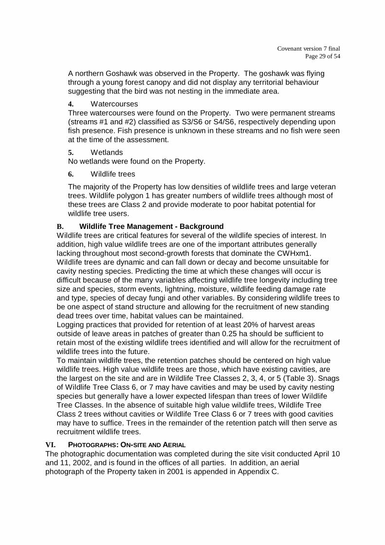
B. Ecosystem description3
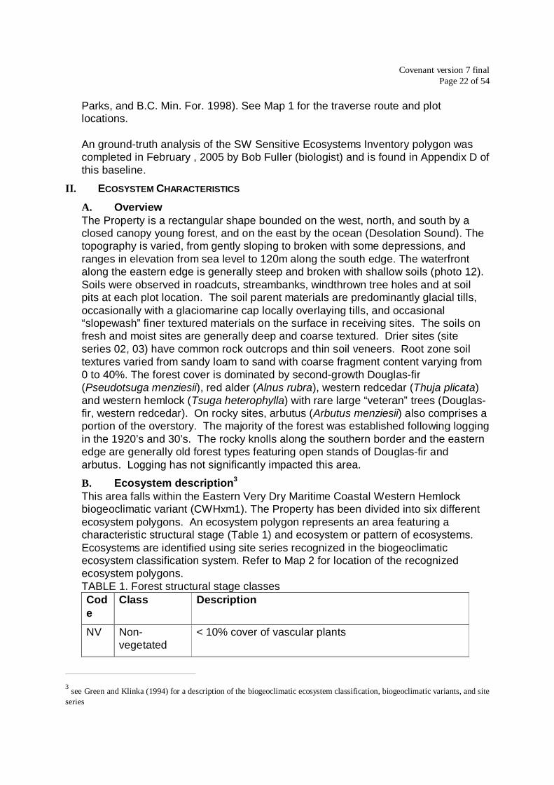
This area falls within the Eastern Very Dry Maritime Coastal Western Hemlockbiogeoclimatic variant (CWHxm1). The Property has been divided into six differentecosystem polygons. An ecosystem polygon represents an area featuring acharacteristic structural stage (Table 1) and ecosystem or pattern of ecosystems.Ecosystems are identified using site series recognized in the biogeoclimaticecosystem classification system. Refer to Map 2 for location of the recognizedecosystem polygons.TABLE 1. Forest structural stage classesCode
Class Description
NV Non-vegetated
< 10% cover of vascular plants
3 see Green and Klinka (1994) for a description of the biogeoclimatic ecosystem classification, biogeoclimatic variants, and siteseries

Covenant version 7 finalPage 23 of 54
Code
Class Description
HB Herb herb dominated communities, < 10% tree cover, < 25%shrub cover
SH Shrub/herb < 20 year old forest, dominated by shrubs <10 m tallincluding conifer regen, tree cover < 10%, < 20 years
PS Pole/sapling trees > 10 m tall and overtopping shrub and herb layer,generally 20 to 40 years
YF Young forest self-thinning evident, canopy layers developed,generally 40 to 80 years
MF Mature forest co-dominant trees mature, well developed understoryoften including advanced regen, generally 80-250years
OF Old forest old, structurally complex stands with snags and CWD,generally >250 years
Ecosystem Polygon 1 is predominantly site series 01 (HwFd – Kindbergia siteseries, slightly dry-fresh/nutrient poor-medium) with a component of site series 05(Cw-Sword Fern site series, slightly dry-fresh/nutrient rich) and 06 (HwCw-Deer fernsite series, moist/nutrient medium). The soils consist of loamy sand to sandy loamglacial tills, with a glaciomarine cap of sand in a portion of the area. This site hasbetter productivity than ecosystem polygon 6, also dominated by site series 01.There is common windthrow throughout this area associated with localized moistsoils. The overstory is a Young Forest structural stage comprised of Douglas-fir(Fd), western hemlock (Hw), red alder (Dr), and western redcedar (Cw).Ecosystem Polygon 2 is predominantly site series 02 (FdPl – Cladina site series,very dry/nutrient poor) and 03 (FdHw – Salal site series, moderately dry/nutrientpoor), with a component of site series 01. The soils are shallow coarse loamy sandon fractured hummocky granitic bedrock. This ecosystem polygon occupies crestand upper slope positions. This area is largely inaccessible, and was not harvestedalong with the rest of the Property in the 1920’s. The overstory is a gappy OldForest structural stage dominated by Fd and arbutus.Ecosystem Polygon 3 is predominantly site series 02 and 03, and is located in crestslope positions. The soil consists of a thin dry organic veneer over bedrock. Thissite has low forest productivity (photo 15). The overstory is a gappy Young Foreststructural stage comprised of Fd with a minor amount of Cw.Ecosystem Polygon 4 is predominantly site series 03 (FdHw – Salal site series,moderately dry/nutrient poor) with a component of site series 02 (FdPl – Cladinasite series, very dry/nutrient poor) and poorer quality site series 01 (HwFd –Kindbergia site series, slightly dry/nutrient poor). The soils are shallow coarseloamy sand over hummocky granitic bedrock. This site is drier than the surroundingsites due to the shallow, coarse textured soils and the upper slope and crest slopepositions. The overstory is a generally Young Forest structural stage dominated byFd with a component of Cw and a minor amount of Hw. The Hw trees show a

Covenant version 7 finalPage 24 of 54
moderate incidence of Hemlock Dwarf Mistletoe (Arceuthobium tsugense) infection,which is common in the Hw throughout the area. Rare Fd veteran trees occur in thisecosystem polygon.Ecosystem Polygon 5 is predominantly site series 06 with a component of siteseries 07 (Cw-Foamflower site series, moist/nutrient rich). The soil consists of deepglacial tills. This ecosystem polygon is generally located in lower slope, moisture-receiving positions, resulting in moist soils. This ecosystem polygon has a highercomponent of deciduous trees, particularly Dr. This site has moderate (to high)forest productivity. The overstory is a Young Forest structural stage comprised ofCw, Dr, and Hw with a component of Fd.Ecosystem Polygon 6 is predominantly site series 01 (HwFd – Kindbergia siteseries, slightly dry /nutrient poor) with a component of site series 03. The soilsconsist of relatively shallow loamy sand to sandy loam glacial till. This site haslower productivity than ecosystem polygon 1. The overstory is a Young Foreststructural stage comprised of Fd and Cw.
C. Soil Erosion RiskThroughout the Property, soil parent materials are predominantly glacial tilldeposits. These soils are relatively coarse textured and well drained, with localshallow areas where bedrock approaches the surface. No areas at significant risk oferosion were found on the Property.
D. Rare Plant Species And Plant CommunitiesRare plant species which potentially may be found on Cortes Island were selectedfrom the species database maintained by the Committee on the Status ofEndangered Wildlife in Canada4 (COSEWIC). Species considered outside therange represented by the study area were excluded (eg. high elevation alpineareas, Interior of B.C.).Rare plant communities, which potentially may be found on Cortes Island, wereobtained from the Conservation Data Center5 (CDC) natural plant communitytracking lists for the CWHxm1 biogeoclimatic variant.Ecosystem polygon 2 represents a red-listed plant community as recognized in theCDC tracking lists. This is the CWHxm1/02 site series (FdPl - Rhacomitrium) with acomponent of CWHxm1/03 site series (FdHw – Salal), supporting an Old Foreststructural stage. No significant vegetation features were noted elsewhere on theProperty. The ecosystems within the majority of the Property are commonthroughout the region. These plant communities were younger than recognizedCDC red and blue listed communities.No rare plant species were observed during the field examination, nor have beenrecorded in the CDC element occurrence reports. As vegetation was not fullydeveloped due to the season, many of the listed species would not be visible.However, the ecosystems in which the majority of these species are typically found
4 COSEWIC develops and maintains a national listing of Canadian species at risk, using categories of extinct, extirpated,endangered, threatened, and vulnerable5 the CDC develops and maintains a provincial listing of plant communities, which have become most vulnerable. Red listedincludes plant communities that are candidates for extirpated, endangered, or threatened status in B.C. Blue listed includesplant communities that are vulnerable in B.C.

Covenant version 7 finalPage 25 of 54
did not occur on the Property. Coastal wood-fern (Dryopteris arguta) has beenfound in the southern Gulf Islands on sites similar to the warm aspect areas ofecosystem polygon 2. However it is a large evergreen fern and was clearly notpresent on the Property.
III. WILDLIFE CHARACTERISTICS
A. OverviewHabitat requirements were divided into habitats used for reproduction, and generalhabitat used for the remainder of life history requisites. Generally, reproductivehabitats are more restrictive to a species than the general habitat used for foragingor other life history requisites but often the quality of reproductive habitat dependsupon proximity to and quality of adjacent foraging habitat.Habitats for evaluation were separated into permanent habitat and temporaryhabitat attributes. Permanent habitats include such areas as cliffs, caves, streams,wetlands and lakes (Table 2). These features were mapped when encountered,described, areas of the habitat were estimated, and habitat value assigned. Theoverall habitat rating for these permanent habitats was then modified to reflect thequality of the surrounding foraging habitat.Temporary habitat attributes include such things as forest structure and wildlifetrees, and were described using structural stage (for forest structure) and density forWildlife Tree Classes.TABLE 2. List of permanent habitats associated with rare species potentially foundon Cortes Island.
Designated species
Wetlands northern red-legged frogCaves/crevices Keen’s long-eared myotisLarge Cliffs Peregrine falcon
Open rangeland Peregrine falcon
Streams/RiparianVegetation
Keen’s long-eared myotis, northern red-legged frog,barn owl, sharp-tailed snake
Shallow open water northern red-legged frog
B. Wildlife TreesWildlife trees were classified based upon decay class and species as per theWildlife Danger Tree Assessor’s Course Handbook (6th ed., 2000)(Table 3). Signsof use increase quality rating, as does both tree height and diameter. Westernredcedar and Douglas-fir were rated as the most valuable wildlife tree speciesbecause of the longevity of standing dead trees of these species. Any sign of usewas noted during field assessments. High value wildlife trees are defined as WildlifeTree Classes 3, 4, 5 and, if there is sign of wildlife use (cavities, usually meaningthat part of the tree is dead) Wildlife Tree Class 2. Wildlife Tree Class 6 and 7 treesand, if there is no visible wildlife use, Wildlife Tree Class 2 trees are of lower value.This rating is based both upon the expected longevity of the wildlife trees and ontheir current habitat value.

Covenant version 7 finalPage 26 of 54
TABLE 3. Wildlife Tree Classes1
Class Description
1 Live, healthy, no obvious decay2 Live but unhealthy, internal decay evident, declining,
deformed3 Recently dead, wood sound, fine branches intact4 Dead, wood relatively sound, fine branches fallen but larger
limbs intact5 Dead, wood becoming spongy, most limbs fallen, bark
mostly intact6 Dead, wood soft, limbs fallen, more than half the bark fallen,
greater than 2/3 of tree height remaining erect7 Dead, wood soft, most of bark sloughed, less than 2/3 of
tree height erect1 modified from Wildlife Danger Tree Assessor’s Course Handbook, 2000
C. Habitat DescriptionWildlife species and habitats evaluated on the Property were selected from theCOSEWIC lists for British Columbia. Species on the lists that are not affected byland management practices (eg. whale species, sea otter) and species whoseknown distribution does not approach Cortes Island (eg. grizzly bear, VancouverIsland marmot) were deleted from the list of species to be evaluated. Habitatrequirements for the remaining species were then obtained from the literature.The Property was divided into 2 wildlife polygons differentiated by the density ofwildlife trees (see Map 3 at Appendix A). Most of the Property (wildlife polygon 2)had low densities of high value wildlife trees but one area (wildlife polygon 1) wasnot logged and had moderate to high densities. Most of these trees are Class 2 andprovide moderate to poor habitat potential for wildlife tree users. The northwestcorner of the Property has been logged in the past but moderate densities of largelive veteran trees were observed and will serve as excellent recruitment wildlifetrees.Three streams were observed in the Property. Stream #1 enters the Property fromthe west and is the continuation of a man made drainage ditch. There is poorchannel development along this stream until the stream enters a 4 to 5 m deep drawabout 150 m into the Property from the eastern boundary. Riparian vegetation ispoorly developed along the entire stream length. The stream exits the Property tothe south. This stream would be classified S3 or S6 under the Forest PracticesCode stream classification, depending upon fish presence6. Fish presence isunknown but no fish were seen at the time of the assessment. An unused waterintake was seen in this stream near the southern Property line (see photo 13).A second stream (#2) flows south through the Property. This stream flows in a 2 mdeep draw but has poor riparian vegetation development. This stream would beclassified S4 or S6 depending upon fish presence. A third stream (#3) flows into theocean on the east side of the Property. This stream is ephemeral, is only
6 Forest Practices Code, Fish-stream identification guidebook – second edition.

Covenant version 7 finalPage 27 of 54
approximately 60 m in length and does not have a defined channel. It would beclassified S6 as fish presence is very unlikely in this stream.Two small wet areas were seen in the Property. One is along the Tiber Bay Roadand the other lies about 100 m south of the first. Both wet areas are very small.The wet area by the Tiber Bay Road has an area of open water and providesmoderate habitat potential for designated species. The second area, located withinthe forest, is seasonally wet but dry in the summer months (ie. dry at time ofinspection). Both sites are too small to be classified as wetlands under the ForestPractices Code.Several rock cliffs are found within the Property boundary, but these cliffs are poorlyfractured, wet and on cold aspect slopes, providing low habitat value. No areas ofwell fractured warm aspect rock cliffs were noted.Overall habitat value for designated species is moderate. Potential nest sites forcavity-nesting species were found in wildlife polygon 1 but foraging habitat islimited. A portion of old forest in a closed forest state is located within wildlifepolygon 1. This area provides high quality habitat for northern goshawk. The morecommon open old forests, and the dense, generally single-storied young forestsacross most of the Property provide low to moderate habitat potential for northerngoshawk. The streams have virtually no riparian vegetation development and do notprovide high quality habitat for any of the designated species.TABLE 4. Summary of wildlife habitat featuresPolygon Permanent
habitat (PH)Value ofPH
Structuralstage (Table 1)
Density of highvalues wildlifetrees (Table 5)
1 – oldforest
stream low OF 3
2 –remainder of forest
2 streams low YF 1
TABLE 5. Density and distribution classes for wildlife tree assessmentClass Distribution
1 a few sporadically occurring individuals2 several sporadically occurring individuals3 many uniformly distributed individuals4 a single patch or clump5 a few patches or clumps6 several well-spaced patched or clumps
IV. HUMAN-ENGINEERED FEATURES
A. RoadsFour private driveable roads are located within the Property. The main road intoTiber Bay (“Tiber Bay Road”) is a wide, regularly graded loose surface access road.A second road (“Mary Point Road”) goes south through the western end of theProperty and splits just within the Property boundary. The western fork here is

Covenant version 7 finalPage 28 of 54
signed as a private road, and provides access to a residence immediately outsidethe Property boundary. Waterlines from this residence are associated with Stream#1 within the Property (photo 13). A private sawmill near Tiber Bay, located outsidethe Property boundary, is accessed by a short spur road (“Mill Road”) on the southedge of the Property. A driveable hydro powerline road is located on the extremewest edge of the Property and may enter the Property in places.In addition to the private roads noted above, there is evidence of a number oflogging roads that once provided additional access within the Property. Thesehistoric logging roads are now at various levels of decay. The routes followed bythese former roads are shown on Map 4 at Appendix A.The following summarizes the observed human engineered features:
1. Tiber Bay Road
2. Mary Point Road
3. Southwest Private Road
4. Hydro Road on western boundary
5. Mill Road
6. Waterlines associated with Stream #1.
7. Hydro line along Tiber Bay Road and along Hydro Road on western boundary.
B. BridgesThere is one bridge within the Property. Stream #2 is crossed by the Mary PointRoad over a log bridge.
C. Hydro LinesThere are hydro lines within the Property, running the length of the Tiber Bay Roadparallel to the road and along the Hydro Road along the western boundary.
V. KEY ATTRIBUTES
A. SynopsisThis section describes important features from the ecosystem and wildlifecharacteristics, which are relevant for land management and development.
1. Ecologically significant habitatThe portions of the Property within ecosystem polygon 2 (coincides with wildlifepolygon 1) comprises ecologically significant habitat that encompasses a red-listed plant community representing the CWHxm1/Fd-Pl – Cladina site serieswith an old forest structural stage. This area also provides high quality habitatfor northern goshawk.
2. Rare plant speciesNo rare plant species were found on the Property.
3. Rare wildlife species
Covenant version 7 finalPage 29 of 54
A northern Goshawk was observed in the Property. The goshawk was flyingthrough a young forest canopy and did not display any territorial behavioursuggesting that the bird was not nesting in the immediate area.
4. WatercoursesThree watercourses were found on the Property. Two were permanent streams(streams #1 and #2) classified as S3/S6 or S4/S6, respectively depending uponfish presence. Fish presence is unknown in these streams and no fish were seenat the time of the assessment.
5. WetlandsNo wetlands were found on the Property.
6. Wildlife trees
The majority of the Property has low densities of wildlife trees and large veterantrees. Wildlife polygon 1 has greater numbers of wildlife trees although most ofthese trees are Class 2 and provide moderate to poor habitat potential forwildlife tree users.
B. Wildlife Tree Management - BackgroundWildlife trees are critical features for several of the wildlife species of interest. Inaddition, high value wildlife trees are one of the important attributes generallylacking throughout most second-growth forests that dominate the CWHxm1.Wildlife trees are dynamic and can fall down or decay and become unsuitable forcavity nesting species. Predicting the time at which these changes will occur isdifficult because of the many variables affecting wildlife tree longevity including treesize and species, storm events, lightning, moisture, wildlife feeding damage rateand type, species of decay fungi and other variables. By considering wildlife trees tobe one aspect of stand structure and allowing for the recruitment of new standingdead trees over time, habitat values can be maintained.Logging practices that provided for retention of at least 20% of harvest areasoutside of leave areas in patches of greater than 0.25 ha should be sufficient toretain most of the existing wildlife trees identified and will allow for the recruitment ofwildlife trees into the future.To maintain wildlife trees, the retention patches should be centered on high valuewildlife trees. High value wildlife trees are those, which have existing cavities, arethe largest on the site and are in Wildlife Tree Classes 2, 3, 4, or 5 (Table 3). Snagsof Wildlife Tree Class 6, or 7 may have cavities and may be used by cavity nestingspecies but generally have a lower expected lifespan than trees of lower WildlifeTree Classes. In the absence of suitable high value wildlife trees, Wildlife TreeClass 2 trees without cavities or Wildlife Tree Class 6 or 7 trees with good cavitiesmay have to suffice. Trees in the remainder of the retention patch will then serve asrecruitment wildlife trees.
VI. PHOTOGRAPHS: ON-SITE AND AERIALThe photographic documentation was completed during the site visit conducted April 10and 11, 2002, and is found in the offices of all parties. In addition, an aerialphotograph of the Property taken in 2001 is appended in Appendix C.

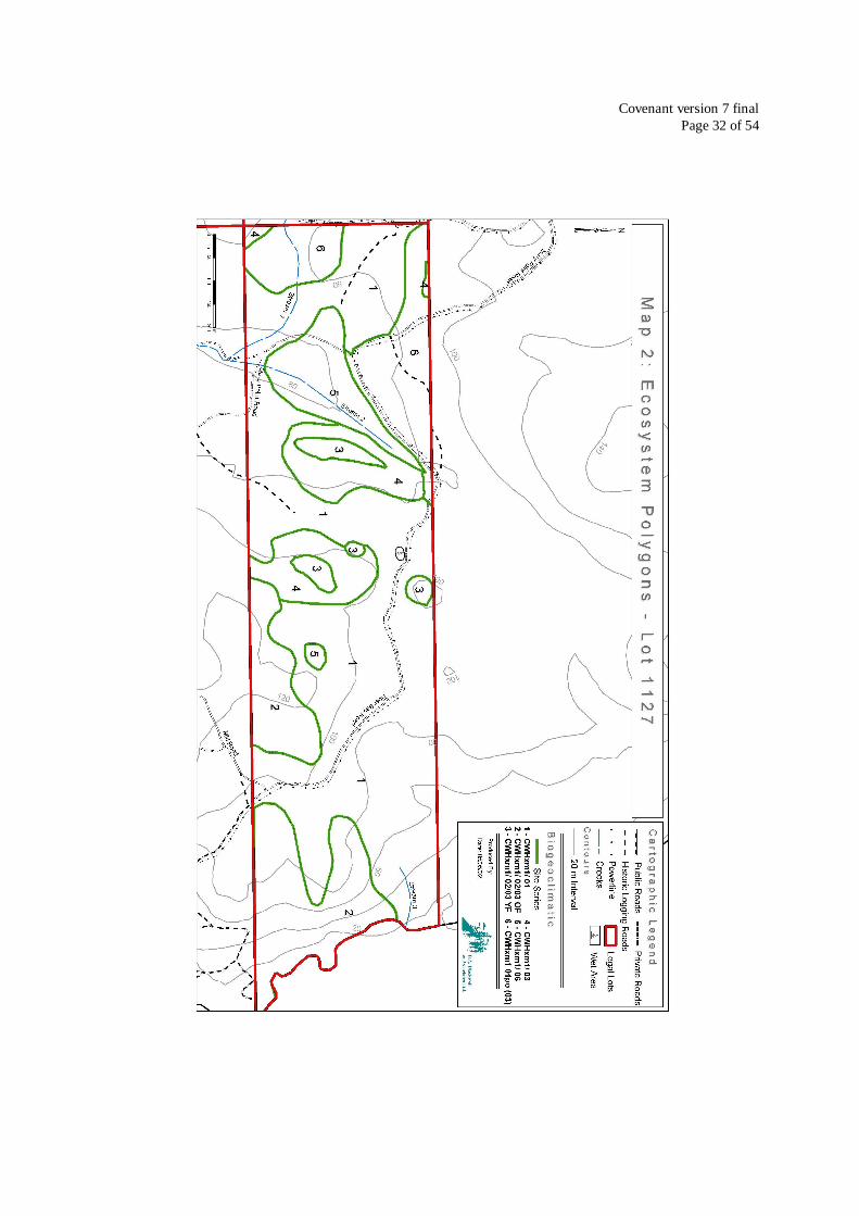
Covenant version 7 finalPage 30 of 54
The locations of the photographs are detailed on Map 4 with the numbers 1 to andincluding 20 thereon corresponding to the locations at which photographs weretaken.
VII. MAPSThe following four maps of the Property are attached to this report in Appendix A:Map 1: Traverse Route and Plot LocationMap 2: Ecosystem PolygonsMap 3: Wildlife PolygonsMap 4: Photo LocationsDisclaimer: Cartographic information including Property boundaries, road locations,power lines, streams, and contours from Weyerhaeuser Company Ltd. GIS databases,obtained through Olympic Resource Management, Vancouver, B.C. Polygonboundaries, plot locations, traverse routes, waterlines, and refined stream locationsbased on consultants field estimations. These are not surveyed locations.
VIII. RECOMMENDED MONITORINGThis Property should be monitored for compliance with the Conservation Covenantonce per year at a minimum.
IX. CAVEATTo the extent that this document conflicts with the Conservation Covenant, the text ofthe fully executed Conservation Covenant shall control.

Covenant version 7 finalPage 31 of 54
Appendix A
Maps
Covenant version 7 finalPage 32 of 54

Covenant version 7 finalPage 33 of 54
Covenant version 7 finalPage 34 of 54

Covenant version 7 finalPage 35 of 54
Appendix B
Vegetation ListUnderstory plant species observed in plot data
Scientific Name Common Name
Achillea millefolium YarrowArbutus menziezii arbutus (madrone)Arctostaphylos columbiana hairy ManzanitaAsplenium viride green spleenwortBlechnum spicant deer fernCarex obnupta slough sedgeCarex sitchensis sitka sedgeChimaphila umbellata prince’s-pineCircuta douglasii Douglas’ water hemlockCladina portentosa coastal reindeerCladonia squamosa dragon cladoniaDicranum fuscescens dusky fork mossGaultheria shallon SalalGalium trifidum small bedstrawGoodyera oblongifolia rattlesnake-plantainHolodiscus discolor OceansprayHylocomium splendens step mossJuncus effusus common rushKindbergia oregana Oregon beaked mossLinnaea borealis TwinflowerLycopodium clavatum running clubmossLysichiton americanum skunk cabbageMahonia nervosa dull Oregon-grapeMalus fusca Pacific crab appleMoneses uniflora single delightPaxistema myrsinites FalseboxPeltigera britannica freckle peltPlagiothecium undulatum flat mossPlagiomnium insigne coastal leafy mossPleurozium schreberi red-stemmed feathermossPolytrichum juniperinum juniper haircap mossPolystichum munitum sword fernPteridium aquilinum bracken fernRhytidiadelphus loreus lanky mossRhizomnium glabrescens fan mossRibes lacustre black gooseberry

Covenant version 7 finalPage 36 of 54
Scientific Name Common Name
Rosa gymnocarpa baldhip roseRubus spectabilis SalmonberryRubus ursinus trailing blackberryScapania bolanderi yellow-ladle liverwortSelaginella wallacei Wallace’s selaginellaSisyrinchium douglasii satin-flowerSphagnum girgensohnii common green sphagnumSpiraea douglasii HardhackTiarella trifoliata three-leafed foamflowerVaccinium parvifolium red huckleberry

Covenant version 7 finalPage 37 of 54
Appendix C
Aerial Photograph

Covenant version 7 finalPage 38 of 54
Appendix D
Ground-truth of Sensitive Ecoystems of District Lot 1127
Robert Fuller, B.Sc.
1.0 Background
District Lot 1127 is located on east side of Cortes Island at the north end of the Strait ofGeorgia. The lot is located adjacent to the ocean on the northwest side of Tiber Bay;Tiber Bay Road, which provides access to Tiber Bay, bisects the property. The projectarea is located at the northern end of the Strait of Georgia Ecosection and within theEastern Very Dry Maritime Coastal Western Hemlock biogeoclimatic variant(CWHxm1).
A baseline assessment of the property1 was completed in April 2002 prior to theplacement of the Conservation Covenant by The Nature Trust of British Columbia onthe subject lot owned by Weyerhaeuser Ltd. The property was divided and mapped intosix different ecosystem polygon types as a result of the assessment. Two portions ofthe property, represented by ecosystem polygon 2, were designated as “Leave Areas”(protected areas) in The Nature Trust Covenant. These two polygons where designatedas older forest1.
The current owner has proposed that five home sites be placed within one of the areasdesignated as a “Leave Area”.
Cortes Island is located within the Sensitive Ecosystems Inventory (SEI) of theSunshine Coast and Adjacent Islands project area. This inventory identifies rare andfragile terrestrial ecosystems along the Sunshine Coast and adjacent islands. Sensitiveterrestrial ecosystems include old forest, woodland, herbaceous terrestrial, riparian andwetland areas. Mature forest, cliff and seasonally flooded areas are also identified asimportant ecosystems2. Five sensitive ecosystem polygons have been mapped whollyor partially within DL 1127. The rock outcrop area that contains the proposed five homeconstruction sites lies within Sunshine Coast SEI polygon number 6816. The label forthis polygons is as follows: 60% conifer woodland (FdPl – Rhacomitrium site series)stage 5; 30% conifer woodland (FdHw – Salal site series) stage 5; and 10%herbaceous terrestrial stage 2. The land area covered within DL 1127 by The NatureTrust “Leave Area” on the east side of Tiber Bay Road and SEI polygon 6816 aresimilar although their boundaries are not identical.
2.0 Methodology
An assessment of the area covered by SEI polygon 6816 within DL 1127 wascompleted during a site visit conducted on February 21 and 22, 2005. Ms. A Mortifee
1Blackwell and Associates Ltd. and Iverson and MacKenzie Biological Consulting Ltd., 2002.2 BC Conservation Data Centre. Sensitive Ecosystems Inventory of the Sunshine Coast and Adjacent Island

Covenant version 7 finalPage 39 of 54
identified the location of the proposed home building sites during a tour of the site.Ecosystem features were observed while traversing the vicinity of SEI polygon 6816 onfoot; the perimeter of the polygon was also traversed in order to assess the potentialecological and SEI boundaries. Information was collected on physical sitecharacteristics and vegetation at reconnaissance level inspections during theassessment.
3.0 Results
The boundary of SEI polygon 6816 has been modified slightly, as a result of ground truthing,to create two polygons containing woodland ecosystems in the area between Tiber Bay Roadand the shoreline (see accompanying air photograph). One of these woodland polygons,approximately 3.6 ha in size, is located entirely within DL 1127. A separate woodland polygon(about 3.8 ha in size) straddles the southern boundary and occupies approximately 1.6 ha ofthe property. Together these polygons occupy approximately 5.2 ha of the property and 7.4 hain total. These woodland ecosystems are situated on hummocky bedrock outcrops that slopesteeply off to the east towards the ocean. Terrain within the area is undulating to hummocky;slopes on the west side near Tiber Bay Road are gentle to moderate while those on the eastside are moderately steep to steep with some cliff faces.
Although the general area was logged in the 1920’s and 30’s1, this bedrock outcrop areaappears not to have been logged at the time, as stumps were evident around the perimeter butnot within the polygon. However, the woodland area has been subject to past disturbances asevident by the presence of many fire-scarred mature trees and snags. The woodland is in theearly mature structural stage; a 49cm diameter Douglas-fir growing on a poor site was found tobe approximately 85 years in age. Some larger Douglas-firs up to one meter in diameter arepresent in the polygon.
The polygon is dominated by two site series, the FdPl – Rhacomitrium (CWHxm1/02)and the FdHw –Salal (CWHxm1/03). The FdPl – Cladina site series occurs on crestand upper slope positions on bedrock outcrops with very shallow and shallow soils.Sites are very dry and nutrient very poor to poor. It has an open tree canopy that isdominated by Douglas-fir (Pseudotsuga menziesii) and lodgepole pine (Pinuscontorta); small arbutus are scattered in the sub-canopy especially on the warmersoutheast aspects. The low shrub and herb understorey are generally poorly developedand contain low covers of salal (Gaultheria shallon), baldhip rose (Rosa gymnocarpa),red huckleberry (Vaccinium parvifolium), dull Oregon-grape (Mahonia nervosa),western fescue (Festuca occidentalis), oatgrass (Danthonia sp.), sword fern(Polystichum munitum), twinflower (Linnaea borealis) and early hairgrass (Airapraecox). The generally very developed and moderately diverse moss layer consists ofDicranum sp., step moss (Hylocomium splendens), red stemmed feathermoss(Pleurozium schreberi), juniper haircap moss (Polytrichum juniperinum), Oregonbeaked moss (Kindbergia oregana), electrified cat’s-tail moss (Rhytidiadelphustriquetrus), Peltigera sp., Cladina sp., and Cladonia lichens. Cladina lichens areoccasionally dominant on the crest positions. Some roadside rock moss (Rhacomitrium
1 Blackwell and Associates Ltd. and Iverson and MacKenzie Biological Consulting Ltd., 2002.

Covenant version 7 finalPage 40 of 54
canescens) is present on rock substrate in the canopy gaps above the east facingslopes.
The FdHw – Salal site series occurs also occurs on crest and upper slope positions withmoderately dry moisture regimes and poor nutrient regimes. Soils are generally shallow tobedrock (20 –100 cm). Douglas-fir is dominant in the tree canopy; western redcedar (Thujaplicata) and lodgepole pine may be present especially in the sub-canopy. The low shrub layeris generally dominated by salal; dull Oregon-grape, red huckleberry, baldhip rose and westernredcedar are also present as associates. The well developed moss layer is dominated by amixture of step moss, red-stemmed feathermoss, Oregon beaked moss and lanky moss(Rhytidiadelphus loreus). This ecosystem is more common on the slopes of the polygon.
The FdPl – Rhacomitrium (CWHxm1/02) is red-listed by the BC CDC while the FdHw – Salal(CWHxm1/03) is blue-listed 3.
A small amount (10% or less) of SEI polygon 6816 consists of herbaceous terrestrial (HB)ecosystem as shown on the label.
Mature forest ecosystems are present in the area immediately adjacent to the woodlandecosystems on the west (between the Tiber Bay Road and the woodland), north, and eastboundaries of the woodland. A strip of mature forest connects the two woodland polygons ontheir western ends. The area situated in between the two woodland areas on the southernproperty boundary is young forest (as shown on the Sunshine Coast SEI mapping). Themature forest consists of the red-listed Western hemlock - Douglas-fir / Oregon beaked-moss(CWHxm1/01) and mature, forested FdHw – Salal (CWHxm1/03) ecosystems.
3 BC Species and Ecosystems Explorer. 2003. Victoria, British Columbia, Canada. Available:http://srmapps.gov.bc.ca/apps/eswp/

Covenant version 7 finalPage 41 of 54

Covenant version 7 finalPage 42 of 54
SCHEDULE B
Attached to and forming part of the Covenant Agreement between ECO INITIATIVESINC., Owner, and TLC THE LAND CONSERVANCY OF BRITISH COLUMBIA,Covenant Holder, and REGIONAL DISTRICT OF COMOX-STRATHCONA, CovenantHolder, dated the __ day of 2007.
1. RESTRICTIONS ON ALL RESIDENTIAL USE AREAS
1.1 In respect to those areas identified on the Plan as the Residential Use Areas,except with prior written permission of the Covenant Holders, at the CovenantHolders’ sole discretion, the owner(s) shall not:
(a) lease, or rent any portion of the land for any purpose; and
(b) create septic areas outside of the allocated septage treatment sites asoutlined in the attached map (Schedule D, Section 2).
2. RESTRICTIONS ON RESIDENTIAL USE AREA 1
2.1 The following restrictions apply to all the Land found within Residential Area 1,which is marked as Covenant Area 1, 2 and 3 on the Plan:
(a) No more than six dwellings are permitted;
(b) Each dwelling, its outbuildings, and garden must not exceed 2500 squarefeet; and
(c) Any new buildings or structures are limited to those which are reasonablynecessary to the sustainable use of the land provided they do notinterfere with the stewardship of the Land as set out in this Agreementand must be in quiet harmony with the natural features of the land.
2.2 The Owner must never apply or introduce any herbicide, insecticide or pesticide.
2.3 The following restrictions apply to that portion of the Land not in the ServiceCorridor and at a distance of greater that 20 metres from the residence, exceptwhere the Covenant Holders at their sole discretion, have approved of an actionin writing:
(a) no other acts may be carried out on or in respect of Land which, in theopinion of the Covenant Holders, acting reasonably, may have adetrimental impact on the Land;
(b) no component of the Land, including soil, gravel or rock, may bedisturbed, explored, or moved for commercial purposes from the Land;

Covenant version 7 finalPage 43 of 54
(c) no native plant or tree, living or dead may be damaged, pruned, cut,harvested or otherwise interfered with, except as allowed under ScheduleC, and
(d) no grazing of domestic animals; and
(e) see also S5.0 Restrictions on the Land, preceding.
3. RESTRICTIONS ON RESIDENTIAL USE AREA 2
3.1 The following restrictions apply to all the Land found within Residential Area 2,which is marked on the Plan as house sites G and H:
(a) No more than two dwellings are permitted;
(b) Each dwelling, its outbuildings, and garden must not exceed 5000 squarefeet;
(c) Any new buildings or structures are limited to those which are reasonablynecessary to the Sustainable use of the land provided they do notinterfere with the stewardship of the Land as set out in this Agreementand must be in quiet harmony with the natural features of the land;
(d) Waterfront access is limited to a small pathway or wooden infrastructurethat is no wider than 1.5 metres; and
(e) No dock or pier structure may be built.
3.2 The Owner must never apply or introduce any herbicide, insecticide or pesticide.
3.3 The following restrictions apply to that portion of the Land not in the ServiceCorridor and at a distance of greater that 20 metres from the residence, exceptwhere the Covenant Holders at its sole discretion, have approved of an action inwriting:
(a) no grazing of domestic animals;
(b) no other acts may be carried out on or in respect of Land which, in theopinion of the Covenant Holders, acting reasonably, may have adetrimental impact on the Land;
(c) no component of the Land, including soil, gravel or rock, may bedisturbed, explored, or moved for commercial purposes from the Land;and
(d) no native plant or tree, living or dead may be damaged, pruned, cut,harvested or otherwise interfered with, except as allowed under ScheduleC.

Covenant version 7 finalPage 44 of 54
4. RESTRICTIONS ON RESIDENTIAL USE AREA 3
4.1 The following restrictions apply to all the Land found on the house sites assurveyed points of Residential Area 3, which is marked on the Plan as housesites A, C, D, E, F, I and K:
(a) No more than seven dwellings are permitted;
(b) Each dwelling, its outbuildings, and garden must not exceed 3500 squarefeet;
(c) Any new buildings or structures are limited to those which are reasonablynecessary to the Sustainable use of the land provided they do notinterfere with the stewardship of the Land as set out in this Agreementand must be in quiet harmony with the natural features of the land,
(i) All paths must be constructed with either permeable materials orwooden boardwalks;
(ii) Driveways must be built with permeable materials except as requiredto reduce environmental impact; and
(iii) Gardens should be minimum impact to the local environment andshould be predominantly native species.
(d) No removal of entire trees for viewscape is allowed;
(e) Service Corridors must not exceed 2.5 metres wide within the ProtectedArea; and
(f) No exposed fires may be lit.
4.2 The Owner must never apply or introduce any herbicide, insecticide or pesticide.
4.3 The following restrictions apply to that portion of the Land not in the ServiceCorridor and at a distance of greater that 20 metres from the residence, exceptwhere the Covenant Holders at its sole discretion, have approved of an action inwriting:
(a) no grazing of domestic animals;
(b) no other acts may be carried out on or in respect of Land which, in theopinion of the Covenant Holders, acting reasonably, may have adetrimental impact on the Land;
(c) no component of the Land, including soil, gravel or rock, may bedisturbed, explored, or moved for commercial purposes from the Land;and
Covenant version 7 finalPage 45 of 54
(d) no native plant or tree, living or dead may be damaged, pruned, cut,harvested or otherwise interfered with, except as allowed under ScheduleC.
5. RESTRICTIONS ON ECOSYSTEM-BASED FORESTRY AREA
5.1 In respect to those areas identified in Schedule D, Section 2, as Ecosystem-based Forest Area, except with prior written permission of the Covenant Holders,at the Covenant Holders’ sole discretion, the following restrictions apply:
(a) no acts may be carried out on or in respect of the Ecosystem-basedForestry Area which, in the opinion of the Covenant Holders, actingreasonably, may have a detrimental impact on the composition, structureand functioning of the Ecosystem-Based Forestry Area; and
(b) the Owner shall be prohibited from constructing any dwelling houses,accessory buildings or any other structures within the Ecosystem-BasedForestry Area except for ecoforestry processing or community basedactivities as allowed under 5.2 (d) (x) below.
5.2 The Owners shall provide a plan within one year of the registration of thisagreement at the Land Titles Office (the "Ecosystem-Based Forest Plan"), whichincludes both a development plan and a forest management plan. The forestmanagement component will include a forest inventory and description of thecharacter and condition of the forest in the Ecosystem-Based ForestManagement Area. The development component will include all development tothe Land. The Plan will explain how the purpose of the covenant will beachieved, and will detail uses and the types of activities for the Ecosystem-Based Forest Management Area for a fifty-year period. The followingrestrictions apply to the Ecosystem-Based Forest Management Plan and itsactions:
(a) The Ecosystem-Based Forest Management Plan will be revised as oftenas necessary or within five years of registration, whichever comes first,and not less frequently than every ten years;
(i) The Ecosystem-Based Forest Management Plan and every revision toit shall be submitted to TLC The Land Conservancy of BritishColumbia for approval. TLC The Land of British Columbia will have 60Business Days to comment on and to evaluate the Management Plan.If TLC The Land Conservancy of British Columbia fails to comment onthe Management Plan within 60 days TLC The Land Conservancy ofBritish Columbia will be deemed to have approved of it; and
(ii) Only TLC The Land Conservancy of British Columbia needs toapprove the plan.
(b) The Ecosystem-Based Forest Management Plan shall be consistent withthe purpose and details of this Covenant;

Covenant version 7 finalPage 46 of 54
(c) The Ecosystem-Based Forest Management Plan must be prepared by aregistered professional forester who has experience in Ecosystem-basedForestry;
(d) The Ecosystem-based Forest Management Plan must always include thefollowing standards and principles:
(i) Use Adaptive Management forestry where consistent monitoring ofindicator species ensure the success of the Sustainable nature of themanagement;
a. include, without limitation, trees, and sufficient trees to transitionto mature snags and wildlife trees in due course as existing snagsand mature trees decay and lose their wildlife values, inaccordance with the wildlife tree management informationprovided in the Report;
(ii) ensure no clear-cutting or removal of tree patches great than 35meters in diameter;
(iii) ensure an annual cut that is less than 75% of the actual 5 year annualincrement growth over any 5 year period including removed windfalls,and removal of trees due to road or dwelling construction;
(iv) ensure an annual allowable cut will be evenly distributed throughoutthe Ecosystem-Based Forest Management Area and be representativeof the plant communities including:
a. the annual cut is spread among tree species; and
b. the annual cut is spread among tree age class;
(v) ensure an accurate log book of any timber removal including thelocation, environmental conditions such as weather, species type, andscaled volume. These records must be made available to theCovenant Holders and all dwelling owners with reasonable notice;
(vi) create an annual report that outlines financial value added, hours ofemployment created, and other benefits to the local community andthe local economy;
(vii) retain or encourage any old-growth characteristics, and seed trees;
(viii) any cutting of trees shall, along with encouraging the development ofan increased frequency of Douglas-fir where appropriate, ensure thatthe trees cut are proportionate to the species in the stand in question;
(ix) Trees removed shall be representative of the species mixture in thestand, with the exception of Douglas-fir where appropriate, which shallbe the favoured leave tree; when trees are cut, all bucking, limbing,and topping shall occur in the forest, and any parts of the cut tree notused shall remain distributed on the forest floor where the tree wascut; and

Covenant version 7 finalPage 47 of 54
(x) use the existing system of skid trails/skid roads for removal of anytrees from the Ecosystem-Based Forestry Area, and any new skidtrails, ecoforestry processing and community clearings or buildings(including wood processing area, buildings, storage and otherstructures which remove land from permanent ecoforestry use)constructed shall not exceed 4% of the Ecosystem-Based ForestryArea.
6. RESTRICTIONS ON PROTECTED AREA
6.1 In respect to those areas identified in Schedule D, Section 2 as Protected Area,except with prior written permission of the Covenant Holders, at the CovenantHolders’ sole discretion, the following restrictions apply:
(a) no introduction of non-indigenous flora or fauna;
(b) no buildings or structures of any kind shall be built except as allowed inSchedule C;
(c) no trade or business shall be carried on within the Protected Area exceptas permitted in Schedule C;
(d) no road, driveway, walkway, bicycle, or other path, parking area, dock, orramp shall be erected, placed or maintained, or permitted to be erected,except that foot trails, fire lanes and other means of access existing at thedate of the Agreement may be maintained substantially in their existingcondition, except as permitted in Schedule C; and
(e) no indigenous flora or fauna shall be removed, destroyed or cut, or be permittedto be removed, destroyed or cut, except as may be necessary to maintain existing foot
trails not exceeding one meter in width, fire lanes or other means of access aspermitted.

Covenant version 7 finalPage 48 of 54
SCHEDULE C
Attached to and forming part of the Covenant Agreement between ECO INITIATIVESINC., Owner, and TLC THE LAND CONSERVANCY OF BRITISH COLUMBIA,Covenant Holder, and REGIONAL DISTRICT OF COMOX-STRATHCONA, CovenantHolder, dated the __ day of , 2007.
1. RESERVED RIGHTS ON ALL RESIDENTIAL USE AREAS
1.1 In respect to those areas identified on the Plan as the Residential Use Area, theOwner reserves the following rights:
(a) to maintain, replace or enhance any permitted residence on the propertywithin the restricted square footage size;
(b) to maintain, replace or enhance Service Corridor(s) including a drivewayfrom Tiber Bay Road to the proposed residences that must not exceed 10metres in width;
(c) to build, maintain, replace or enhance improvements related to theresidence in an area extending not more than 20 metres from theresidence in any direction;
(d) to improve, enhance, restore and rehabilitate the natural environmentunder federal, provincial, and local regulations with:
(i) consultation with a registered professional biologist, or registeredprofessional forester and prior approval of TLC The LandConservancy of British Columbia, not to be unreasonably withheld;and
(ii) completed in a manner planned and approved;
(e) to build, maintain, replace or enhance improvements related to trailways,pathways and benches;
(f) to harvest firewood as required for residential use only within 50 metresaround the dwellings in all directions; and
(g) to light exposed fires in service corridors and roads only.
1.2 The Owner specifically reserves the following rights for Service Corridors:
(a) to construct, maintain, replace or enhance wells or other water sourcesand a septic system or other method of waste disposal such that:
(i) all piping is laid in the Service Corridor as reserved in 1.1 exceptingthose places that make this impossible; and

Covenant version 7 finalPage 49 of 54
(b) to build, maintain, replace or enhance electrical, telephone or otherenergy sources in the Service Corridor as reserved in 1.1.
2. RESERVED RIGHTS ON ECOSYSTEM-BASED FORESTRY AREA
2.1 In respect to those areas identified on the Plan as the Ecosystem-BasedForestry Area, the Owner reserves the following rights:
(a) to conduct commercial activities that are not detrimental to the Land andAmenities and are consistent with maintaining the Land and Amenities ina Sustainable state.
(b) to improve, enhance, restore and rehabilitate the natural environmentunder federal, provincial, and local regulations with:
(i) consultation with a registered professional biologist or registeredprofessional forester and prior approval of TLC The LandConservancy of British Columbia, not to be unreasonably withheld;and
(ii) completed in a manner planned and approved;
(c) to enter into an agreement with The Trust for Sustainable Forestry tomanage the forest in the interest of all dwelling owners with:
(i) consultation with all dwelling owners on the Land pertaining to anyconcerns regarding the Ecosystem-Based Forest Management Plan;and
(ii) approval and consultation with the Covenant Holders on forestryactivity on the Land;
3. RESERVED RIGHTS ON PROTECTED AREA
3.1 In respect to those areas identified on the Plan as the Protected Area, the Ownerreserves the following rights:
(a) to improve, enhance, restore and rehabilitate the natural environmentunder federal, provincial, and local regulations with:
(i) consultation with a registered professional biologist or registeredprofessional forester and prior approval of TLC The LandConservancy of British Columbia, not to be unreasonably withheld;and
(ii) completed in a manner planned and approved.

Covenant version 7 finalPage 50 of 54
SCHEDULE D
Attached to and forming part of the Covenant Agreement between ECO INITIATIVESINC., Owner, and TLC THE LAND CONSERVANCY OF BRITISH COLUMBIA,Covenant Holder, and REGIONAL DISTRICT OF COMOX-STRATHCONA, CovenantHolder, dated the __ day of , 2007.
1. REFERENCE PLAN OF THE RESIDENTIAL USE AREAS ON THE LAND

Covenant version 7 finalPage 51 of 54
2.0 MAP OF THE USE AREAS ON THE LANDThis map uses the updated knowledge based on the ground-truth analysis as perAppendix D of Schedule A.

Covenant version 7 finalPage 52 of 54
SCHEDULE E
Attached to and forming part of the Covenant Agreement between ECO INITIATIVESINC., Owner, and TLC THE LAND CONSERVANCY OF BRITISH COLUMBIA,Covenant Holder, and REGIONAL DISTRICT OF COMOX-STRATHCONA, CovenantHolder, dated the __ day of , 2007.
1.0 SURVEY OF 5 ACRE COVENANT PARCEL

Covenant version 7 finalPage 53 of 54
SCHEDULE F
Attached to and forming part of the Covenant Agreement between ECO INITIATIVESINC., Owner, and TLC THE LAND CONSERVANCY OF BRITISH COLUMBIA,Covenant Holder, and REGIONAL DISTRICT OF COMOX-STRATHCONA, CovenantHolder, dated the __ day of 2007.
1.0 SURVEY OF TRAILL RIGHT OF WAYS

Covenant version 7 finalPage 54 of 54
SCHEDULE G
Attached to and forming part of the Covenant Agreement between ECO INITIATIVESINC., Owner, and TLC THE LAND CONSERVANCY OF BRITISH COLUMBIA,Covenant Holder, and REGIONAL DISTRICT OF COMOX-STRATHCONA, CovenantHolder, dated the __ day of 2005.
1.0 SURVEY OF EASMENT ALONG TIBER BAY ROAD
END OF DOCUMENT