Britannia Beach: a historic town center · COMMUNITY DESIGN STRATEGIES Britannia Beach: a historic...
10
COMMUNITY DESIGN STRATEGIES Britannia Beach: a historic town center Julie Lommerse Plan - Historic Town Centre This scheme is based on two driving factors. The first being that the critical flood area is free of buildings and that no further interventions are applied to the creek. The second is that the contaminated soil is contained rather than capped so water via interflow is stopped from entering Britannia Creek or Howe Sound. As a result, all the historic buildings have been moved into the town area. The street layout is based on the historic axis of the town. Main Street will have views directly to Howe Sound and the Britannia Creek valley. This town site is small but would house essential community and tourist commercial buildings as well as proposed institutional buildings, the hotel, a community centre and a Town Hall. The concept is that people of Britannia Beach can work in this area as well as it serving as a vital tourist area with the museum as the main focus. Other services could be located in this area such as shopping, gas restaurants and banks. The plan intends to evoke a small town feel with trees, sidewalks and plantings. UBC URBAN STUDIO, FALL 2003 Green FRESH EYES ON BRITANNIA BEACH DETAIL DESIGN 66
Transcript of Britannia Beach: a historic town center · COMMUNITY DESIGN STRATEGIES Britannia Beach: a historic...

COMMUNITY DESIGN STRATEGIES
Britannia Beach: a historic town center Julie Lommerse
This scheme is based on two driving factors. The first being that the critical flood area is free of buildings and that no further interventions are applied to the creek. The second is that the contaminated soil is contained rather than capped so water via interflow is stopped from entering Britannia Creek or Howe Sound. As a result, all the historic buildings have been moved into the town area. The stre ut is based on the historic axis of th . Main Street will have views dir Howe Sound and the Britannia valley. This town site is small bu house essential commun tourist commercial buildings ll as proposed institutio ldings, the hotel, a commun tre and a Town Hall. The concept people of Britannia Beach can workas a vitaas the mbe locategas restaintends ttrees, sid
UBC URBFRESH
et layoe townectly to Creekt wouldity and as wenal buiity cenis that
Plan - Historic Town Centre
in this area as well as it serving l tourist area with the museum ain focus. Other services could d in this area such as shopping, urants and banks. The plan
o evoke a small town feel with ewalks and plantings.
AN STUDIO, FALL 2003 GEYES ON BRITANNIA BEACH D
reen ETAIL DESIGN 66
COMMUNITY DESIGN STRATEGIES
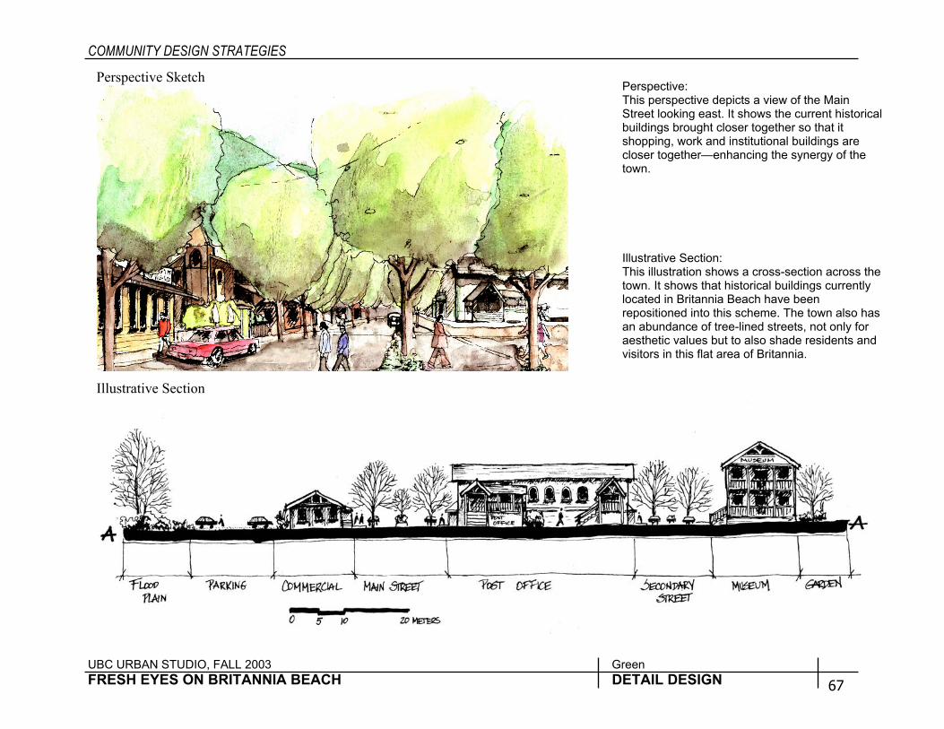
Perspective Sketch
Illustrative Section
IllustrativeThis illustrtown. It shlocated in repositionan abundaaesthetic vvisitors in
PerspectivThis persp picts a view of the Main Street look . It shows the current historical buildings b loser together so that it shopping, institutional buildings are closer tog hancing the synergy of the town.
UBC URBAN STUDIO, FALL 2003 Green FRESH EYES ON BRITANNIA BEACH DETAIL D
e: ective deing eastrought c
work andether—en
Section: ation shows a cross-section across the ows that historical buildings currently Britannia Beach have been ed into this scheme. The town also has nce of tree-lined streets, not only for alues but to also shade residents and
this flat area of Britannia.
ESIGN 67

COMMUNITY DESIGN STRATEGIES
UBC URBAN STUDIO, FALL 2003 Green FRESH EYES ON BRITANNIA BEACH DETAIL DESIGN 68
Living Water Park Katie Murray
Plan View at 1:750 The Britannia flood control manual called for a debris basin in which the expansion of the riverbed did not exceed 55m, was trapezoidal in shape, and did not further the depth of the creek. The current wetland is 48m wide with a depth of approximately 1-1.5m.
Britannia’s new wetland park is a dynamic place for ongoing remediation research and public enjoyment. Observing and juxtaposing lines in the landscape developed the concept of “living water”. The grid was made from the axis of the old mine building, and roads that existed on the site. These man made lines contrast with the more organic lines, which represent the flow line of a natural stream. One could speculate that these lines symbolically represent the path Britannia creek would flow in a more natural state. The wetland not only serves a remediatory function for wastewater and runoff, but also as a debris basin to lessen the impact of flooding. The area was excavated and designed according to flood control standards, and does require regular maintenance to clean out debris. The soils were moved to form a “bermed hill” which further protects the fan from flooding. The poplar grove also remediates runoff before it sinks into the ground water supply.

COMMUNITY DESIGN STRATEGIES
UBC URBAN STUDIO, FALL 2003 Green FRESH EYES ON BRITANNIA BEACH DETAIL DESIGN 69
Perspective view from wetland looking south The park is filled with open spaces and winding paths that change materials throughout. The wetland has a raised boardwalk, bringing the visitor into close contact with the phytoremediation processes. The raised hill in the distance provides a place to enjoy the view to Howe sound, the historic town site, and the mountains beyond. The poplar trees are not only known for their phytoremediation of heavy metals, but also for their beautiful fall color.
Section The grade of the site was changed in order to build a proper debris basin/wetland area. The black line represents the new, improved grade, and the lower brown line represents the old grade. Note the change in the stream channel, raised berm, and existing town garden, which is now a phyto remediatory research garden. (far right)

COMMUNITY DESIGN STRATEGIES
UBC URBAN STUDIO, FALL 2003 Green FRESH EYES ON BRITANNIA BEACH DETAIL DESIGN 70
Waterfront Hub Jennie Suen
Waterfront Plan The Waterfront is a hub in the transportation network where people from the train, cruise lines, bus, or cars are deposited. It is a cultural, historic and natural beauty destination and as such welcomes tourist and resident alike.
The Waterfront of Britannia Beach will help support a vibrant and diversified economy for the Britannia Beach community. Taking from the model of Granville Island, the design integrates community, tourist, recreational and retail uses within the context of the historic past of Britannia Beach. A consolidation of buildings, marina and dock onto the contaminated site, limit the footprint of the Waterfront, increasing naturalized areas and providing more access to water. As with Granville Island, pedestrian access is throughout and vehicle traffic shares the roadways with the pedestrian. Excluding the Boat House and train station, there is a total of 2440 square meters of commercial space interspaced within 12 buildings creating a total of 81 jobs. All commercial spaces are sized to no greater than 111.5 square meters (1200 square feet). Building size and shape will provide a range of commercial store sizes allowing a cross-section of retail space to be available. Store shops will not be limited to the walls of the building but be encouraged to spill out unto the surrounding outdoor space. Although there is some parking along the one-way road network, most of the parking occurs the peripheral to maintain the central commercial core as parking lot free and pedestrian dominant.
Train Station
Howe Sound
Boat House
Retain Relic Dock House
Britannia Beach
A
A'
Sunset Amphitheatre
Re-establish 1945 Pier configuration, naturalize
Parking Boardwalk
200 m
Raised Tree Beds
Commercial
Dedicated vehicle lanes
Tree
100 0 North
COMMUNITY DESIGN STRATEGIES
UBC URBAN STUDIO, FALL 2003 Green FRESH EYES ON BRITANNIA BEACH DETAIL DESIGN 71
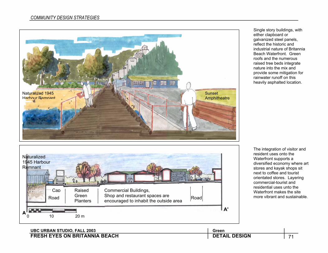
Single story buildings, with either clapboard or galvanized steel panels, reflect the historic and industrial nature of Britannia Beach Waterfront. Green roofs and the numerous raised tree beds integrate nature into the mix and provide some mitigation for rainwater runoff on this heavily asphalted location.
The integration of visitor and resident uses onto the Waterfront supports a diversified economy where art stores and kayak shops sit next to coffee and tourist orientated stores. Layering commercial-tourist and residential uses unto the Waterfront makes the site more vibrant and sustainable.
Cap Road
Raised Green Planters
Commercial Buildings, Shop and restaurant spaces are encouraged to inhabit the outside area Road
Naturalized 1945 Harbour Remnant
0 10 20 m A
A'
Naturalized 1945 Harbour Remnant
Sunset Amphitheatre
COMMUNITY DESIGN STRATEGIES
UBC URBAN STUDIO, FALL 2003 Green FRESH EYES ON BRITANNIA BEACH DETAIL DESIGN 72
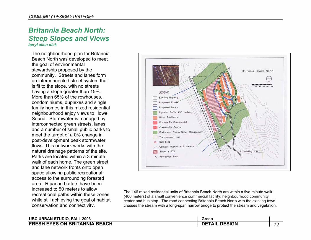
Britannia Beach North: Steep Slopes and Views beryl allen dick
The 146 mixed residential units of Britannia Beach North are within a five minute walk (400 meters) of a small convenience commercial facility, neighbourhood community center and bus stop. The road connecting Britannia Beach North with the existing town crosses the stream with a long-span narrow bridge to protect the stream and vegetation.
The neighbourhood plan for Britannia Beach North was developed to meet the goal of environmental stewardship proposed by the community. Streets and lanes form an interconnected street system that is fit to the slope, with no streets having a slope greater than 15%. More than 65% of the rowhouses, condominiums, duplexes and single family homes in this mixed residential neighbourhood enjoy views to Howe Sound. Stormwater is managed by interconnected green streets, lanes and a number of small public parks to meet the target of a 0% change in post-development peak stormwater flows. This network works with the natural drainage patterns of the site. Parks are located within a 3 minute walk of each home. The green street and lane network fronts onto open space allowing public recreational access to the surrounding forested area. Riparian buffers have been increased to 50 meters to allow recreational paths within these zones while still achieving the goal of habitat conservation and connectivity.
COMMUNITY DESIGN STRATEGIES
UBC URBAN STUDIO, FALL 2003 Green FRESH EYES ON BRITANNIA BEACH DETAIL DESIGN 73
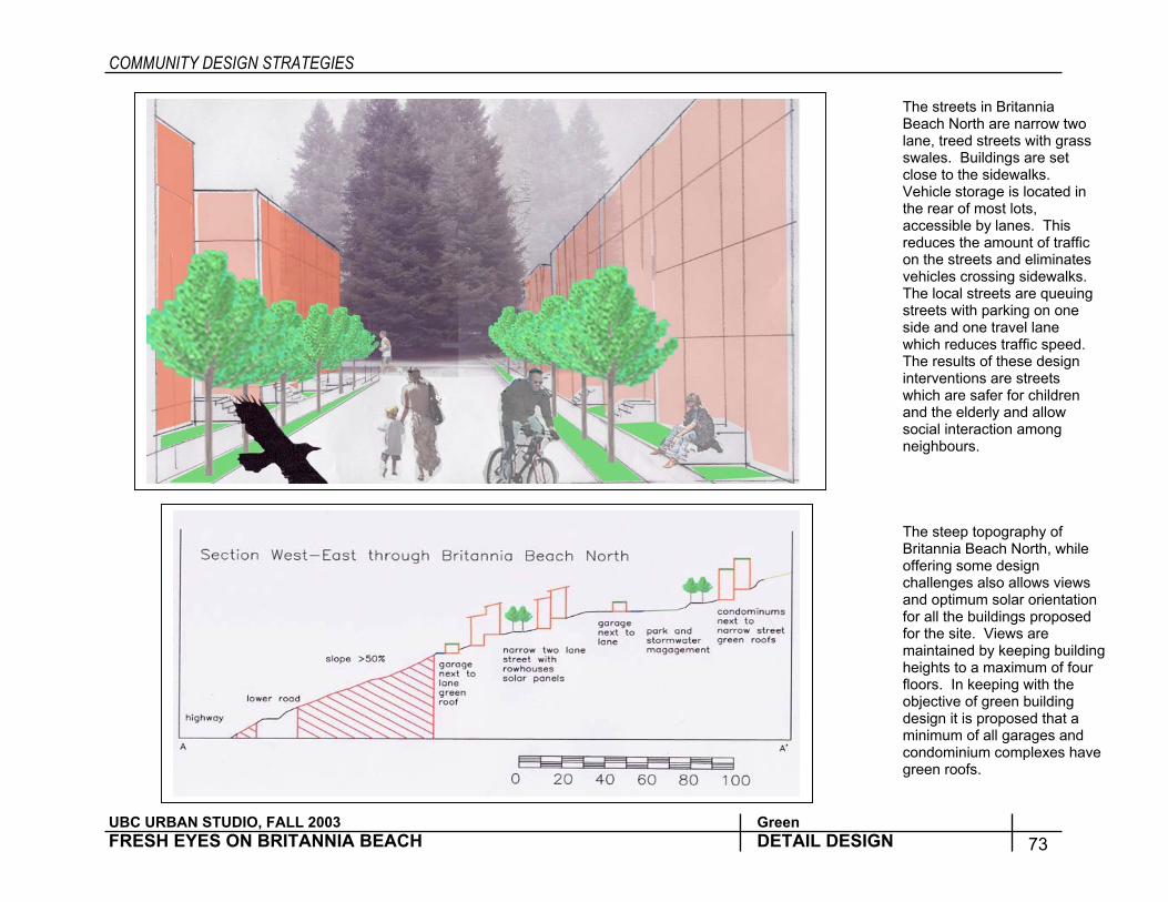
The streets in Britannia Beach North are narrow two lane, treed streets with grass swales. Buildings are set close to the sidewalks. Vehicle storage is located in the rear of most lots, accessible by lanes. This reduces the amount of traffic on the streets and eliminates vehicles crossing sidewalks. The local streets are queuing streets with parking on one side and one travel lane which reduces traffic speed. The results of these design interventions are streets which are safer for children and the elderly and allow social interaction among neighbours.
The steep topography of Britannia Beach North, while offering some design challenges also allows views and optimum solar orientation for all the buildings proposed for the site. Views are maintained by keeping building heights to a maximum of four floors. In keeping with the objective of green building design it is proposed that a minimum of all garages and condominium complexes have green roofs.

COMMUNITY DESIGN STRATEGIES
UBC URBAN STUDIO, FALL 2003 Green FRESH EYES ON BRITANNIA BEACH DETAIL DESIGN 74
South Britannia Center Theresa Cherniak
Plan for South Britannia community center area located at the existing gravel quarry.
The South Britannia center area was designed based particularly on Environmental and Community goals. Elements of the design include: • Community serving commercial
located just off the highway, • Higher density residential close to this
commercial area. • Diversity of housing types on same
street – mixed residential including townhouse, duplex, small lot single family and secondary suites.
• Multi-use pathways and sidewalks throughout community.
• Network of pathways across highway and along waterfront.
• Restaurant and look-out pier located on waterfront close to existing relics – help connect with remainder of waterfront to the north.
• A large community park is located centrally to neighborhood.
• “Green streets and lanes” which infiltrate stormwater and filter it before it reaches the Sound.
• Stormwater is also directed to the community park to infiltrate.
• Highway is ‘tamed’ by activity along the road, a light at main intersection and posted speed limit reduction.

COMMUNITY DESIGN STRATEGIES
UBC URBAN STUDIO, FALL 2003 Green FRESH EYES ON BRITANNIA BEACH DETAIL DESIGN 75
Perspective of Entry to Town Center. This perspective shows the entry to the new South Britannia community. Community related commercial uses such as groceries, shoe repair, dry cleaners, coffee shop, pizza shops and delis would be located in this area. The tree lined street and vegetated swale in the center median filter stormwater while also providing a green swath up to the hills. Narrow streets slow traffic through the area, making it more walking friendly. The community park is one short block behind this shopping area.
Townhouses to Park Section. This section demonstrates some of the green infrastructure used in the new community. Stormwater from the buildings and sidewalk is directed to a planted infiltration swale where is is treated and infiltrated. Stormwater from the streets is directed first to a gravel strip where parking is allowed, and then to the park, where it can be stored and slowly infiltrated. Wide sidewalks separated from the one-way traffic lane provide a pleasant walking experience.


![Town of Southampton: Town-owned Historic Cemeteries [revised] · 2009-10-19 · 2 of 66 [Town of Southampton: Historic Cemeteries/Town-owned/2] NORTH SEA BURIAL GROUND 16 Millstone](https://static.fdocuments.in/doc/165x107/5f584ac8442dc608ff7d67e1/town-of-southampton-town-owned-historic-cemeteries-revised-2009-10-19-2-of.jpg)