
BRIEF STATEMENT ON THE HYDROLOGY OF THE ... near Georgetown. The channel depth of the Sampit River...
17
BRIEF STATEMENT ON THE HYDROLOGY OF THE SAMPIT RIVER AREA NEAR GEORGETOWN, SOUTH CAROLINA By James M. Cahill U.S. GEOLOGICAL SURVEY Open-File Report 84-243 Columbia, South Carolina 1984
Transcript of BRIEF STATEMENT ON THE HYDROLOGY OF THE ... near Georgetown. The channel depth of the Sampit River...

BRIEF STATEMENT ON THE HYDROLOGY OF THE
SAMPIT RIVER AREA NEAR GEORGETOWN, SOUTH CAROLINA
By James M. Cahill
U.S. GEOLOGICAL SURVEY
Open-File Report 84-243
Columbia, South Carolina
1984

UNITED STATES DEPARTMENT OF THE INTERIOR
WILLIAM P. CLARK, Secretary
GEOLOGICAL SURVEY
Dallas L. Peck, Director
For additional information write to:
District Chief U.S. Geological Survey, WRD 1835 Assembly Street, Suite 658 Columbia, South Carolina 29201
Copies of this report can be purchased from:
Open-File Services Section U.S. Geological Survey Federal Center, Box 25425 Denver, Colorado 80225 (Telephone: 303/234-5888)

CONTENTS
Page
Abstract. .............................. 1
Introduction. ............................ 1
Description of study area ...................... 1
Stratigraphy. ............................ 3
Upper Cretaceous formations. .................. 3Tertiary formations. ...................... 5Quaternary sediments ...................... 5
Occurrence of ground water. ..................... 5
Impact of oil spills. ........................ 9
Seismicity. ............................. 9
References. ............................. 12
ILLUSTRATIONS
Figure 1. Map showing location of proposed plant site, pipelines,and observation wells near Georgetown, South Carolina. ,
2. Lithologic section along A-A* in vicinity of Sampit River near Georgetown, South Carolina. ............
3. Map showing seismicity in South Carolina and adjoiningStates, 1754-1975. ................... 11
TABLES
Table 1. Stratigraphic units of the lower Coastal Plain, Georgetown County, South Carolina. .................
2. Laboratory water analyses from selected wells in the shallow aquifer in the vicinity of Winyah Bay area, Georgetown County, South Carolina .........
111
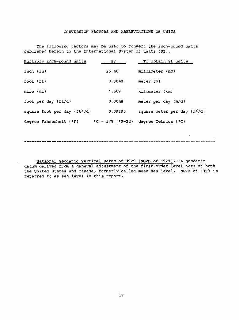
CONVERSION FACTORS AND ABBREVIATIONS OF UNITS
The following factors may be used to convert the inch-pound units published herein to the International System of units (SI).
Multiply inch-pound units By To obtain SI units
inch (in) 25.40 millimeter (mm)
foot (ft) 0.3048 meter (m)
mile (mi) 1.609 kilometer (km)
foot per day (ft/d) 0.3048 meter per day (m/d)
square foot per day (ft^/d) 0.09290 square meter per day
degree Fahrenheit (°F) °C = 5/9 (°F-32) degree Celsius (°C)
National Geodetic Vertical Datum of 1929 (NGVD of 1929). A geodetic datum derived from a general adjustment of the first-order level nets of both the United States and Canada, formerly called mean sea level. NGVD of 1929 is referred to as sea level in this report.
iv
BRIEF STATEMENT ON THE HYDROLOGY OF THE SAMPIT RIVER AREA NEAR GEORGETOWN, SOUTH CAROLINA
By James M. Cahill
ABSTRACT
The Carolina Refining and Distributing Company is planning to locate an oil-refining plant near Georgetown, South Carolina. To aid in the preparation of an environmental impact statement, a description of the stratigraphy, ground-water resources, and an assessment of possible seismic activity that may occur in the Winyah Bay vicinity has been prepared. Additional data will be required to quantitatively evaluate the impact of an oil spill on the shallow aquifer in the area.
INTRODUCTION
This report, based on available data, is a brief description of the stratigraphy and ground-water resources and an assessment of possible seismic activity that may occur in the Winyah Bay vicinity. The report was prepared in cooperation with the U.S. Army Corps of Engineers.
The study area includes a 14-square mile area bounded on the north by latitude 33°22'30", on the south by latitude 33°17'30", on the east by longitude 79° 17'30", and on the west by longitude 79°25'00'1 . Emphasis was placed on the area bounded by Pennyroyal Road, the north bank of the Sampit River, the South Carolina State Port Authority dock area, and the east bank of Turkey Creek (fig. 1).
DESCRIPTION OF STUDY AREA
Climate of the area is characterized by warm, humid summers and mild winters. Mean monthly precipitation varied from 7.29 inches in July to 2.38 inches in November during the 22-year period, 1959-81, at the National Weather Station near Georgetown, South Carolina. The mean annual precipitation for 1951-80 reported by the National Weather Service at the Georgetown station was 64.7 inches. Mean monthly temperatures range from about 47.8°F in January to 80.9°F in July.

33* 2 Z 33"
53* 17 30"
A* CITY OF GCORGCTOWN
Figure 1. Location of proposed plant site, pipe lines, and observation wells near Georgetown, South Carolina.

The main surface drainage in the area is the Sampit River which empties into Winyah Bay at Georgetown. The principal tributaries to the Sampit River in the study area are: Pennyroyal Creek and Turkey Creek which join together before entering the Sampit River, and Whites Creek which empties into the Sampit near Georgetown. The channel depth of the Sampit River at low tide ranges from about 25 to 35 feet in the lower 3 miles of the river (Johnson, 1978), and the width of the river is about 1,500 feet where it empties into Winyah Bay and narrows to about 500 feet about 6 miles inland.
The topography of the area consists of highlands that are nearly level to gently sloping having moderately to excessively well drained soils, and lowlands along the flood plain of the Sampit River that are nearly level and poorly drained (Stuckey, 1980). The forest cover in the highlands is predominantly pine and hardwood, whereas the lowlands consist of marshland and swamps. Agriculture in the area is minimal.
STRATIGRAPHY
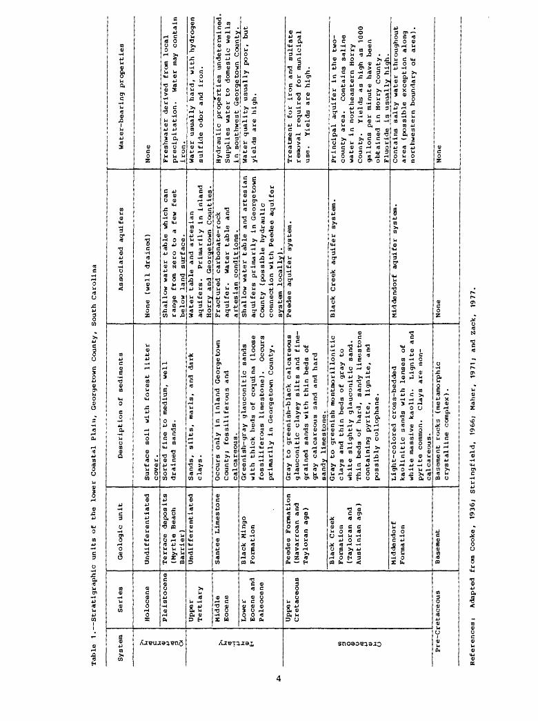
The surficial sediments consist of Pleistocene to Holocene age fluvial and marine deposits. The sedimentary sequence overlying basement rocks in the Winyah Bay area is composed of unconsolidated and consolidated sediments consisting of sand, clay, limestone, and sandstone that range in age from Upper Cretaceous to Holocene. Table 1 describes the stratigraphic sequence of the Winyah Bay area as discussed by Johnson and Du Bar (1964) and Zack (1977).
Upper Cretaceous Formations
The Upper Cretaceous formations in Georgetown County rest on the basement rock and consist, in ascending order, of the Middendorf Formation, the Black Creek Formation, and the Peedee Formation (Zack, 1977). The total thickness of the Upper Cretaceous section is about 1,800 feet.
The Middendorf Formation contains layers of medium to coarse sand and silty clay. An isopleth map by Zack (1977) shows the top of this formation at about 1,100 feet below sea level in the Winyah Bay area. The thickness of the formation in this area is about 700 feet.
The Black Creek Formation, which rests on the Middendorf, consists of about 700 feet of laminated, dark-gray clay interbedded with gray to white, fine to very-fine glauconitic, phosphatic, and micaceous quartz sand. The upper surface of this formation in the Winyah Bay area lies between 450 to 500 feet below sea level.
The Peedee Formation, about 250 feet thick, is composed of dark gray, fine, clayey sand with semi-consolidated interfingering sandstones and limestones. Glowacz and others (1980a, p. 13) report the base of this unit near the city of Georgetown to lie at a depth of about 726 feet below sea level. Zack (1977, fig. 4) indicates that the base of the Peedee Formation is about 480 feet below sea level at a test well drilled for the city of Georgetown.
T)hi fB
1nfBrrftnfBgCO
fflCOfB
13ft
n ffl k< coCO (Brr 3
P* 3P- rrp- 3 HfB C
no ?r
Cretaceous
n c(l> ''C(T Qfti ^oA
gto
"a 30 P-3 a.3 a ft »ft 3H* Qi-
0 03 H
Ml
ft »< sr B> p-P* H p- 0 kCO P- rr P- srB> rr ft P- ft h fB 31fB 3 P- O
C 0 Cfl P- P-co 3 co n o
§P* h{< W fB
3 a ft a> 3
* a> o"0 ft CO hiP- 3
1 (B fBi X ft
*^r ft)
0
fP- O
z03fB
Z03
o o c M p> C COft P- P- CO< 3 rr ICfl sr CT
fBft t_i p. hi tr1 a> aft P- 3 »
3 3 n0 P- Cfl3 ft
1 fB 0 Ml
pa
3p-aft,W
3O>0hi Ml
ft*Q&Ml (Bhi
COk<
COrr
i
3 fr OOHOH fB 3
fB rr ft rrZ -H.fB >n 3 K 0 Cflft CO(B CO CO i-i p- ft3 CT P"
P" ftcr ft <0c n t3 X BIa o rtft <B m< rr
p- fto o sr Ml 3 hi
cft ft Chi p- lOft 0 3" ft 3 C kO C
ft
S» ~ >fl B5C ^ 0 P1CO ft hi ftrr K 3 Op- p> ft * 3 0 rrp- H p- nft ft 0 H3 3 3 fB
fB
(S 3 *"(B &* *
fl O i-3 « O O 0 O 3" 3" p- h[ CO 3 p- p- ft ftco ft 3 rr i< »<O* p- CT ftp< 3 fB CO ft 0
3 CO P- O. vQ O lO vQ hjo o sr ft IBP< *0 "i rr sr IBp< < P1 P- 3C H 3- K 3 P-
"0 P- ft COsr rr hi (a o* srft ft & P1 ft3 - « ft C. 3ft C CO 0 P> Cfl n 3
P- ft C 0 ft vQ 3 3 Mi 33 a p- o P- K ft lO hift p- fl P-fB M O ft P1 » p- < p-
3 co 0ft (t ft ft 3 3 Cfl 3 0 P- a ft O> ft
0 p*3 OfB
COP1
Op^*
nfB
xftcp- HIft
CO*<
COft§
**J 0 uQ O 0 tjM CT ft) 0 &> 0 ^C rr H- c rr c H-0 ft) M 3 (l> 3 3
P- 3 3 K K P-a ft Cfl P- "0 fB O> 3 ft BI
*0 H P*P- P- fB >< 3 fB CO 3 hi p. C B> £
»3 ~ *ft Z (BK ft CBp- < a,0 (V IBhj h| (Bft h|3 0 ^
ft 0Bl 3 M
vfi 3CB ft ft ^ 3 ft
a* p*03
tt iQ vfi iQ Oft H hi ^ hj3 ft ft Bl fta. K p- c "<
>< 30 O m 0 rrP. ft g, 3 03 O CO rr vQ(B ft ft p- hiCO hi 3 O fBft a a. ft 0 0 CO n 33 C P> P- ft CO * SU CO
p- < srCO rt (B 1ft 3- < cr3 P*a> rr co ft
3" p- 0ft P- P; TT3 3 ft £u CO O
cr ftsr fB » p- ft a* 3 nH B & ftC. H
0 i-h (B"3^8
(B CO
Vn9. a.fBfB
Cp-MlfBnCO
urt
8
C H HCfl (j H
5 ft
ft s
P- 3(B h rr^"* fP
fB h| . tC i CO C CC SC 3 P* rr cco o P- a. 3- p-C H 3 CO n> O l-»>V hi C ft O ISp" < rr ft co 3 Hp< fB CO ft ft< O ft ft P-
0 ff 3" hi p. Ssr c ft P- 3 3p- 3 < vQ CO fta rr a 3- sc sr sr < o co » a* ft H a
fB CO hi M ftIB < P- *3 30
0 fB 1OO
r^* ^
ft H hi (B P-
03- M, gp- 0
uQ hj fty 3 3 »
3 COtr c n P* p- HI
"0 »& ft P- »
1
Tertiary
C W Fft 0 0 t-1 o «fB fB (B03".O fBfB3 &*ft 3
a.
v o0 P-hi ft3 nrrP- 20 P-3 3
U30
0 Hi £ On o p- HP- Cfl ft fB
§co 3* aP- 3
p- P- 3" Cfl
»< ft n iH*" 0 ^3 C O* ft
Cfl (B H;o a (B P- CO U3OP- P<H 3 o a> kC (B Mi Cft co nft rr n C0003
§3 *Q P-
£,£.£. n ~ 3 n"0 ft C CO3 O ftft 0 P1 3^ o o a. c o u hi CA
CO ft
co n n BI cfl< o o kQ srCO 3 C C ftft 3 3 P- P>
§fB rr MI p<n K ft o rr hi 4
p« p- ^. Cfl C 0 "0 £O 3 0 *D 0"ft CO hj rtP* £ Cfl P- (BP* P* P* 3 hi < ft cr ft _ S- M H rr' v n p §
ft sr >< P-(B K fta. a. P- ft hi g ftft ft" 3
c o a.ft p< ft
»C P- o ft»C O hi hip- kC rrHi ft fBft ft COh| O p-
5 3
K £p* ftft rrH1 (Ba H CO
a> "c
W 30 P-o a.3 P*ft ft
CflBI
pf
ftft
Fp-3ftCOft0
ft
o n ofr 0 O P* C On 3 c ft rr Hft * 0 0 C MI 3 CO 0 P1 CO <
up. p-P1 3p-Ml P-ft 3
P Q)8 3co a>ft O 3 fta> o
kCftff
ft ft "13ft c a>ft P- Oca MI rrp- ft Cft 11 H
OO £ O3 BI &*a> rt hip- ft crft hi 0P- 3 0 rr ft
§ &?* P* 1
ft h|0
» n3 ^a.
P- Cfl SC3 C <
Cfl »5 n0 P- ftC P- Cft fB P1=r co P-
hi ft £ Oft P1 |(B £
P- CO ft *D3* ft rr rt nP- K ft OiQ3- C CO
ftp>
^"80n
0"Cft
S11^0 £ S hi 0 ftiQ P-(P 0. (p
ff i " £ ft C3 CO 3
rr a>n P- ftS
O ft ft
3 £ a rr ft 3< p< p- P- 3
CO fta.
H Cft *OH ^0ft ftP- hiBlh{
fc<
C3a. p-MlMlfth|ft3rrp-BIft
&
O Cflp- ftK a.
CO CO
(0p-
ftCO
3(V
^CO«
fta>
frh{X
X ft £
hi c rrH P- ft< Ml hi
ftft h{ ft
s.? B;O n> n> *tj0 H fthi P- 3ic 3 a.ft »ft n »0 P- h| £ P- ftJ3 ^ jp
COn P- p-0 3 frC 3 3 P-rr 3p- Mft BICO 3. a.
CO £C BIp" ftMi fBSi *"*ft C
CO0 Ca, »0 P1
Quaternary
t)ftH>COrr05ft3ft
CD ~ i-3BI 3 ft
^ ^ *"^p- ft ftft p* 0hi ft ft««*
co a.ft ft ft b o 8 3" CO
p-rrCO
& Cfln o ft H p- rt3 ft ft a.&MlCO P-ft 3
CO ft c
8aP-c3
£ft
p>
cr H cflft ft 3* P> 3 ft0 lO P1£ (^ t~*
0P1 Ml Cft H 3 0 £asm
ftCfl N ftC ft hiR hiMI o rrft ^ 0 rr crft 0 P1
ftft*
Mil"
ft P-£ 0
Mlft Oft Blft 3
p- *o "dh{ hi hiC ft ft3 n co . P- y
"0 £p- ft ft rrft ftrr ^ p-o a
< 3 ftft3 srCb ft)
^*tH** Q.hf «
§ £ P-
ft3"
3"
&
O
ft3
p-
£ ft» a, rift iti
Q
ft
0 0 0O BI 3 HftftP-3
SC0P100ft3ft
C3ap-MlHifth{ft3ft P-BIft
8,
O CO
§ 5 ft Mlh| ft 0
ft
CO0p-p-
£ p-ftsrM^
0
ftCOrr
p-ftft ft
Z03ft
*«>^ftP1 P1
&
ft P-3 $a
z03ft
Cfl
COft13
enfthip-
ftCO
oft0p"Q
kJDp-
ncp-ft
D ftCOohi
D" ^p- i3
0Ml
COftap.3ft3ftCO
JJ>
CO
8op-ftrra.
JBcp-Mlft
CO
£
m ft i
7 '|hip-
3
»0hi
0
(l>
hi ftP- ft CO

Tertiary Formations
Throughout most of Georgetown County/ thin beds of fine clayey sand, fine calcareous sand, and coquinas of Tertiary age overlie the Peedee Formation (Zack, 1977). These Tertiary formations include the Black Mingo Formation, Santee Limestone, and Duplin Marl. At one time the Duplin probably covered the entire area, but transgressions of the sea across the land surface have eroded most of these sediments (Cooke, 1936).
Thickness of these formations is not available in the vicinity of Georgetown, South Carolina. Zack (1977) included the Tertiary and Holocene sediments with a thickness of 210 feet as one unit in his geologic cross section of the area.
Quaternary Sediments
Overlying the Tertiary formations are sands, marls, limestones, silts, and clays. These sediments make up terrace complexes which were deposited at different stands of the sea as sea level fluctuated during Pleistocene time (Glowacz and others, 1980a).
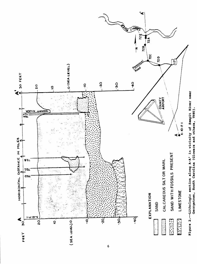
Fine-grained sands in the Winyah Bay area can be traced northeastward to the North Carolina state line. These sediments form a "dune belt" which was termed the Myrtle Beach Bar by Johnson and Du Bar (1964). Figure 2 shows a profile (section A-A') of Quaternary sediments across the Sampit River between Turkey Creek and Georgetown. This section shows that most sediments above sea level are sand. The sediments below sea level are fossiliferous sand, calcareous silt, marl, and limestone.
OCCURRENCE OF GROUND WATER
Large quantities of ground water are available in the saturated sediments at Georgetown County. Artesian conditions occur in the deep sediments, and a free water surface (water table) occurs in the shallow sediments. Only the shallow aquifers in the Winyah Bay area are recharged locally. Deeper artesian aquifers are recharged in outcrop areas near the Fall Line and have lenses or beds of clay that retard downward migration of contaminates from the surface.
The Middendorf encompasses several high-yielding aquifers, but the contained water is salty in the study area. Most of the potable water supply for municipal or industrial purposes in the area is withdrawn from the Black Creek aquifer (table 1). The aquifer responds as an artesian system, and the quality of the water is acceptable for most uses. Withdrawal of ground water in the Georgetown area has lowered water levels to 50 feet below sea level (Zack, 1977).
pee
rH
OR
IZO
NT
AL
- D
IST
AN
CE
|M
34
(SE
A
EXPLANATION
SAND
CA
LC
AR
EO
US
S
ILT
OR
M
AR
L
SA
ND
W
ITH
FO
SS
ILS
P
RE
SE
NT
LIM
ES
TO
NE
Figu
re 2. Lithologic section along
A-A*
in vicinity of
Sa
mpit
River near
Georgetown,
Sout
h Carolina (Glowacz and
others,
1980).
Another source of artesian water is the Peedee Formation. Although large quantities of water are available from the Peedee aquifer system, it is only used locally due to excessive concentrations of iron, hydrogen sulfide, and sulfate in the water (Zack, 1977).
In the Georgetown County area, both water table and artesian aquifers occur in the shallow Tertiary and younger sediments that supply potable water to private domestic wells. The water-bearing sands of these aquifers are often discontinuous and are recharged primarily by local precipitation.
The shallow water-table aquifer occurs in the near surface sandy sediments. Ground water is discharged from the shallow aquifer by evapotranspiration, pumping, and seepage to surface-water bodies. The greatest loss of water by evapotranspiration probably occurs between the months of May to September when ambient air temperatures are above 70*F. The general direction of water movement in the shallow water-table aquifer is to discharge points in low areas such as streams or swamps.
The shallow aquifer in the study area is composed of well sorted, fine to medium-grained sands. Glowacz and others (1980a) report that the transmissivity of the shallow aquifer is about 1,340 ft^/d in the very permeable sand and much less in finer soils. These authors also state that the rate of ground-water flow in the shallow aquifer is about 1 ft/d with a very low or nearly level hydraulic gradient.
South Carolina Department of Health and Environmental Control, Office of Environmental Quality Control, Ground-Water Protection Division, established a network of shallow water-quality monitoring wells in Georgetown County (Glowacz and others, 1980a). These wells were used to investigate potential pollution from land disposal of wastes. An evaluation, by this State agency, of the background water-quality data indicates that the shallow aquifer in several areas in Georgetown County has potential for drinking water supplies. One of these areas is located in the Pennyroyal Road section.
Table 2 lists chemical constituents and physical properties of water from wells (see fig. 1 for location) in the vicinity of Pennyroyal Road (Glowacz and others, 1980a). Water analyses from these three wells indicate that dissolved solids, hardness, specific conductance, and pH increase with depth. Well WlO-y1, which is screened at 42 feet, had the greatest amount of total dissolved solids. Total dissolved solids are less near land surface than at depth, an indication that local precipitation is the source of recharge to the shallow aquifer.
The shallow aquifer system south of Georgetown is important as a suitable source of water for domestic use. However, the chemical quality of the water is variable. Some water may need treatment for iron, but in most cases, the water is suitable for drinking supplies.

00
Table 2. Laboratory water analyses from selected wells in the shallow aquifer in the vicinity of
Winyah Bay area, Georgetown County, South
Carolina3
(results in parts milligrams per liter except specific conductance and pH
)
fk M 0) g @ rH rH
01 *
W10-y
1
W1
0-y
2
XlO
-f 1
^ .C ft «J TJ c o>
0)
01
0)
<4-<
H
U
£CD
-H 4
2
23 13
0 c a H o rt A
o <o
e<
o 5
<3
<3
0 0> ^
<0
.05
<0
.05
<0
.05
u j ,
0) i £ 0
M H
0.2
0.7
0.3
0) 4-* J2
TO
U
0 5
fH
ft
0.0
7
0.0
7
<0
.02
*-~ 10 O 1 H
U H O 50 9 10
£*
rj
CO 0) a
xs:
- 4 0.9
1.0
e d o tn
20 15
3.2
^~
l
^J -H
ro
58
rH
(0
rH
(0*C
10
17
4
31 34
_ ^ O " ' 0) 10 4-1
rH in < 10 10 10
_ , 1 O 0) o H O rH O 12
13.5
4
, .
ft. ^^ 4> O
H O rH t*
<0.
1
<0.
1
<0
.1
_ n O »_
0) 2 .tj 12 1.4
8
<0
.02
O 0> rH
(0O
t)
S
-H(0
rH
H
0Q
m
22
0
80
59
V) 10 (0 (0 0) c ro
10
10as
o
140
26
29
o0) o c
U
<0
H
4J
4-1
O-H
3
U
-O
0,
OM
U
300
11
5
85
^^ (0 4J H ac 7.1
6.0
6.2
aAnalyaes reported by Glowacz, M.
E.,
and others, 19
80a.
"Well locations on figure
1.
cln solution at time of analysis.
dMicromhos at 25
°C.

IMPACT OF OIL SPILLS
Oil spilled onto the ground will tend to flow downward, with some lateral spreading. The rate of oil movement in the soil will depend on oil viscosity/ soil properties/ and the rate at which the oil has been spilled. As oil moves downward through soils, some of it becomes trapped between individual soil particles and remains behind the main body of oil, which may eventually reach the water table. Thus, the volume of the original oil is continually depleted as it migrates through the soil. In some spills, the volume of the oil is insufficient to reach the water table and remains trapped in the soil. As rainwater later percolates through this zone, some droplets of oil that are weakly attached to the soil will break loose and flush away (American Petroleum Institute, 1980, p. 4, 6).
As the body of spilled oil moves downward, its course is affected by variations in permeability of the soil layers through which it passes. Should the oil encounter an impermeable layer, it will spread laterally, until it becomes immobile or until it comes to the surface where the layer outcrops. Downward movement may be additionally complicated by the presence of thin lenses of clay or other low-permeability material (American Petroleum Institute, 1980, p. 6).
Oil infiltration first occurs by gravity, and if the amount of oil is greater than the retention capacity of the sediments it will reach the capillary fringe of the ground water. A minimal thickness of oil must be established above the capillary zone before lateral migration can occur (Van Dam, 1967). As descending oil approaches the water table, it cannot displace much of the capillary water. Therefore, it will move downward around the water-filled pores and through the larger pores until it encounters water which it cannot bypass. The weight of the oil will depress the water table and the capillary zone will follow it downward, since each capillary must remain attached to its source. The amount of oil at any position in the capillary zone will depend on the amount of capillary water present. The least oil will be near the bottom of the zone, which is heavily saturated with water, and the most oil will be at the top, where there is less water saturation (American Petroleum Institute, 1980, p. 11).
The amount of water in the capillary zone inhibits the lateral movement of the oil. In the upper portion of the zone, where there is little water, the oil may move with only minor interference. Near the middle, movement will be greatly restricted. And, in the lower portion, movement may not be possible at all (American Petroleum Institute, 1980, p. 11).
Consequently, a body of spilled oil will spread over and through the capillary zone. Eventually, with enough time and no addition of new oil, the layer of oil will reduce to a critical thickness and stop moving. The thickness is determined by existing permeability and gradient. The ultimate thickness of the mobile oil will be only a fraction of the thickness of the capillary zone. A sudden, large-volume spill will depress the water table and spread in all directions in a layer above the water table. As the layer

becomes thinner, it will begin to move in the direction of ground-water flow. A slower leak will descend in a narrow cone and spread in the direction of water movement. Lateral spreading will usually be slower than the flow rate of the ground water (American Petroleum Institute, 1980, p. 7). The shallow aquifer in the study area consists of approximately 25 feet of sand underlain by at least an additional 20 feet of sand with shell (Glowacz, 198Gb, p. 56) and is recharged locally; therefore, the shallow ground-water system will probably behave similarly to the preceding discussion.
Fried and others (1979, p. 593) conclude by their experiments that the movement downstream of the oil is governed by dispersion-convection which carries, spreads, and diffuses the hydrocarbon traces. These authors stressed that a body of hydrocarbons which has reached the water table several meters below land surface will have a life time measured in tens of years. The water-table aquifer area as described by Glowacz (1980a) may react similarly. Much of the delay is due to chemical and physical phenomena which modify the purely dispersive movement of the pollution, through adsorption, biochemical decay, and evaporation (Fried and others, 1979, p. 592).
In order to evaluate the impacts that might result from an oil spill, more information would be necessary on the hydrology and hydraulic factors of the area and the use that is being made of the aquifer. The more important factors are the direction of ground-water flow in the shallow aquifer to the point of discharge, hydraulic gradient, porosity of sediments near the water table, hydraulic conductivity of the sediments, and the percolation rate from the land surface to the water table.
SEISMICITY
The characteristics of South Carolina seismicity may be explained by assuming that earthquakes occur when regional tectonic stress exceeds the shear strength of rock within zones of weakness. These weak areas are presumed to be zones of pre-existing failure in the basement rocks underlying the Coastal Plain (Tarr and others, 1981).
The Winyah Bay area has been defined by Tarr (1977) and Tarr and others (1981) to be within the Georgia-South Carolina seismic zone. Tarr (1977) defines a seismic zone approximately 500 km long and 350 km wide that extends on a northwest-southeast oriented longitudinal axis through the cities of Charleston, Bowman, and Orangeburg. This zone covers the entire State of South Carolina and the northeast edge of Georgia. Figure 3 shows that significant seismic activity nearest to the Georgetown area has occurred in the Charleston-Summerville and Orangeburg-Bowman areas.
From March 1973 through December 1979 significant activity occurred within the two areas just noted. In addition, seismic activity occurred in the vicinity of Clark Hill Reservoir on Aug. 2, 1974, as shown on figure 3. Major seismic activity has not been detected in the Georgetown area.
10

STUDIES RELATED TO CHARLESTON, SOUTH CAROLINA, EARTHQUAKE OF 1886
,,.84* 36 r
TENNESSEE
£ NOV. 30, 1973
3> O ,.
O _^-- -
o o
33«
PLARK HILL o RESERVOIR
GEORGIAO
o -V
O
EXPLANATION
MM lnt«naity /0
Macrot«i»mic
Magnitude*
FELT Ml III IV V VI VII VIII \X
oooooooO
1V3-2 1/, 3 3% 4'A 5 5% 6V, 7 7V,
,A *3 G
tfle 43^ T^^TT ^
\ ^o ^»^7
U 50I i i i i 1
/
EORGETOWIf
|ij -
100 KILOMETERS
|
Figure 3. Seismic!ty in South Carolina and adjoining states/ 1754-1975. Earthquakes are indicated by circles of varying sizes, which represent the maximum Modified Mercalli intensities shown in the explanation. Numbers beside the epicenter symbols show the number of events recorded. The macroseismic epicenters were determined from accounts of damage and felt reports, whereas instrumental epicenters were determined from seismographic data (Tarr, 1977).
11

REFERENCES
American Petroleum Institute, 1980, Underground spill cleanup manual: Washington, D.C., API Publication 1628, 34 p.
Cooke, C. W., 1936, Geology of the Coastal Plain of South Carolina: U.S. Geological Survey Bulletin 867, 196 p.
Fried, J. J., Muntzer, P., and Zilliox, L., 1979, Ground-water pollution bytransfer of oil hydrocarbons: _in Journal of Ground-Water, v. 17, no. 6, p. 586-594.
Glowacz, M. E., and others, 1980a, Economic and environmental impact of land disposal of wastes in the shallow aquifers of the Lower Coastal Plain of South Carolina: Volume IV, Summary, Georgetown County: South Carolina Department of Health and Environmental Control, Office of Environmental Quality Control, Ground-Water Protection Division, 100 p.
i 1980b, Economic and environmental impact of land disposal of wastes in the shallow aquifers of the Lower Coastal Plain of South Carolina: Volume V, Appendix: South Carolina Department of Health and Environmental Control, Office of Environmental Quality Control, Ground- Water Protection Division, 71 p.
Johnson, F. A., 1978, A tracer study of the flushing time of the Sampit River estuary, Georgetown, South Carolina: South Carolina Water Resources Commission Report No. 19, 40 p.
Johnson, H. S., Jr., and Du Bar, J. R., 1964, Geomorphic elements of the area between Cape Fear and Pee Dee Rivers, North and South Carolina: Southeastern Geology, v. 6, no. 1, p. 37-44.
Maher, J. C., 1971, Geologic framework and petroleum potential of the Atlantic Coastal Plain and Continental Shelf: U.S. Geological Survey Professional Paper 659, 98 p., 17 pis.
Stringfield, V. T., 1966, Artesian water in Tertiary limestone in the south eastern states: U.S. Geological Survey Professional Paper 517, 226 p.
Stuckey, B. N., 1980, Soil survey of Georgetown County, South Carolina: U.S. Department of Agriculture, Soil Conservation Service, 97 p.
Tarr, A. C., 1977, Recent seismicity near Charleston, South Carolina, and its relationship to the August 31, 1886, earthquake: in Rankin, D. W., ed., Studies Related to the Charleston, South Carolina, Earthquake of 1886 A Preliminary Report, U.S. Geological Survey Professional Paper 1028-D, p. 43-57.
Tarr, A. C., and others, 1981, Results of recent South Carolina seismological studies: Bulletin of the Seismological Society of America, v. 71, no. 6, pp. 1883-1902.
12

Van Dam, J., 1967, The migration of hydrocarbons in a water-bearing stratum, in Hepple, P., ed., Joint Problems of the Oil and Water Industries: Institute of Petroleum, London, 42 p. (Traduction francaise: Revue 1'Eau, Nov. etDec., 1969).
Zack, Alien, 1977, The occurrence, availability, and chemical quality of ground water, Grand Strand area and surrounding parts of Horry and Georgetown Counties, South Carolina: South Carolina Water Resources Commission Report No. 8, 100 p.
13


