Bridges and Tunnels - dallasfreeways.com
36
Transcript of Bridges and Tunnels - dallasfreeways.com

Bridges and Tunnels
Fifty miles inland, on a flat plain drained by small bayous, Houston in its early days did not seem destined to become a city of bridges. There were no rivers to cross and no nearby bays or lakes to block the city’s growth. Although Houston was free of impediments, the addition of a man-made barrier would be the event that propelled Houston into the ranks of the nation’s largest cities. Dredging of the Houston Ship Channel to a depth of 25 feet (7.6 m) was completed in June 1914, and the channel was officially opened by President Woodrow Wilson on November 10 of that year. The rest, one might say, is history, as the ship channel spurred Houston’s industrial boom.
The construction of one great work of infrastructure, the Houston Ship Channel, would ultimately necessitate other construction projects to bridge the man-made divide. Houston would not become a great bridge city on the order of New York City or San Francisco, but would still develop a nice collection of bridges and tunnels to complement its freeway system. In comparison to most cities in the United States, Houston’s major bridge crossings are a relatively modern development, with the first high-level bridge span opening in 1973. With newness comes better design and wider spans, but as this history shows, Houston’s bridges have all had their share of problems.
The complete history of Houston’s bridges, however, predates the construction of the modern Houston Ship Channel. While Houston was still a mosquito-infested outpost on Buffalo Bayou, one of the nation’s more prosperous cities was thriving just 50 miles (80 km) to the south—on Galveston Island. If there is anything that can spur bridge construc-tion, it is money. Bridging the mainland to the wealthy port city of Galveston marks the beginning of Houston’s bridge history.
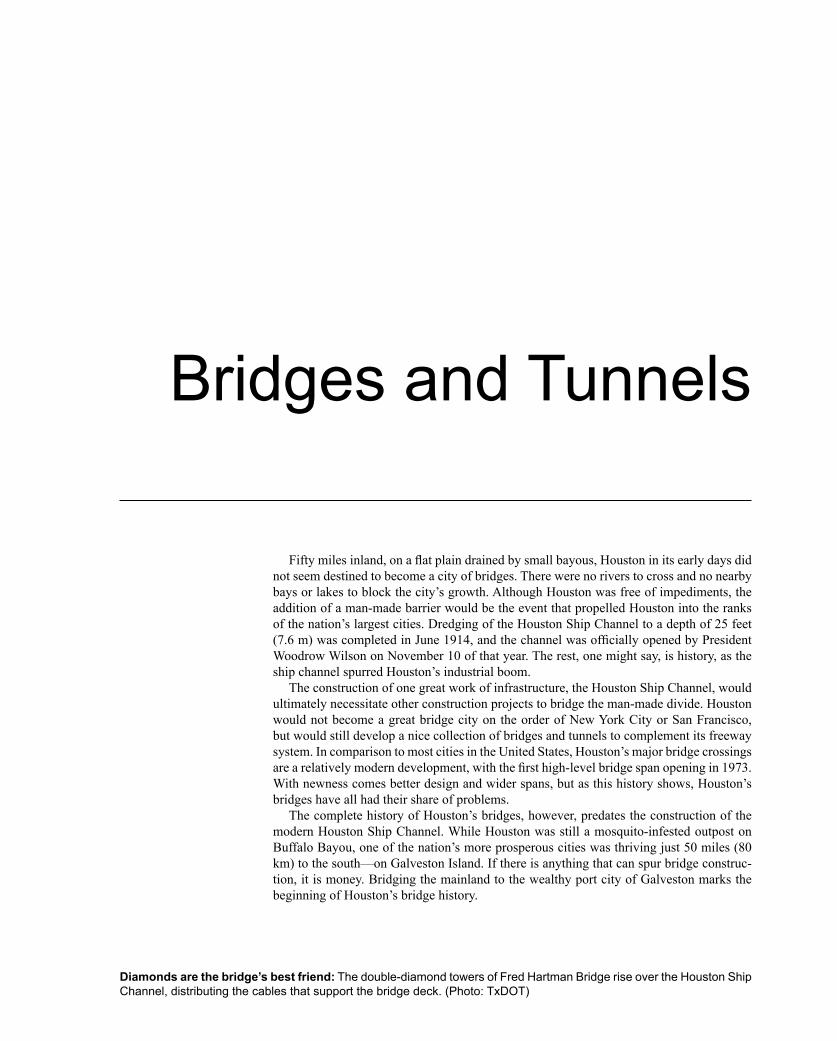
Diamonds are the bridge’s best friend: The double-diamond towers of Fred Hartman Bridge rise over the Houston Ship Channel, distributing the cables that support the bridge deck. (Photo: TxDOT)

342 Houston Freeways
Galveston CausewayFor an island city that has depended on its port and
tourism for economic livelihood, the connection to the mainland is a lifeline. In the 19th century, railroads made the vital connection and hurricanes were the biggest threat to the mainland link. As automobile ownership became widespread, the vehicular crossing became the key life-line, and bridge obsolescence became the biggest threat as traffic volumes rapidly increased. A succession of vehicu-lar crossings that started in 1893 culminated with the pres-ent-day structure, completed in 1964. The next chapter in the story of the Galveston Island crossing will unfold starting in 2003, when the existing structures are replaced by an all-new eight-lane, impact-resistant causeway.
Early CrossingsThe settling of Galveston and its use as a port had its
origins with Spain and Mexico in the late 1700s and early 1800s, but today’s city was begun by real estate investors in 1838, two years after Texas’ independence in 1836. Af-ter Texas entered the United States in 1845, Galveston’s growth was driven by its port, which focused on the cotton trade. Galveston’s population, 13,818 in 1870 and 22,248 in 1880, remained relatively small compared to large cities in the eastern United States. St. Louis, Missouri, completed the Eads Bridge over the Mississippi River in 1874, and New York City completed the landmark Brook-lyn Bridge in 1884. But for a city the size of Galveston still somewhat on the frontier of America, the Galveston Bay crossings were a big undertaking, especially in con-sideration of the challenges posed by hurricanes.1
As railroad construction gained momentum in Texas in the 1850s, the need for a fixed crossing to the mainland became increasingly urgent. In 1857 the city of Galves-ton approved $100,000 in bonds for the construction of a railroad bridge. The bridge was opened in 1860, and was seriously damaged by a hurricane in 1867.2
The first vehicular crossing of Galveston Bay was opened on November 15, 1893. The 2.14-mile (3.7 km) wagon bridge, as it was called, featured 80-foot (24 m) steel truss spans between concrete piers. By the turn of the century there were three railroad trestles and the wagon bridge connecting Galveston Island to the mainland. Then on Saturday, September 8, 1900, the “1900 hurricane” struck Galveston Island, resulting in the deadliest natural disaster in the history of the United States with an esti-mated 6,000 deaths. The wagon bridge was destroyed and all three railroad trestles were substantially damaged. The Santa Fe Railroad crossing was in the best condition and became the focus of an intensive repair operation which the Galveston Daily News described as the “greatest piece of hustling that has ever been witnessed in railroad con-struction.” 3
Every foot of the mainland Santa Fe track from the northern end of the Galveston Bay crossing, known as Virginia Point, to Hitchcock, eight miles (13 km) north-west, had been swept away by the storm. Crews strug-gling to restore the track to Virginia Point worked under extremely difficult conditions, with dead bodies of men and animals strewn along the right-of-way, ground con-sisting of slush and mud, and a shortage of food and sup-plies. Eight days later, on Sunday, September 16, the track had been restored to Virginia Point, and all efforts could be focused on the bridge repair. Most of the piling of the bridge itself remained intact, except for an 800-foot (244 m) section which had been torn out by a drifting steamer. Crews initially worked to build track on the existing pil-ing to the point of the 800-foot breach, then pile drivers went to work to close the gap. Just before dawn on Friday,
Galveston Causeway modern bridgeOpened Southbound: July 26, 1961
Northbound: April 29, 1964Type Pier and beam
Length 1.6 miles (2.6 km)
Vertical clearance 73 feet (22 m)Traffic volume, 2001 64,000 vehicles per dayFuture construction Remove existing bridge, build new
8-lane, impact-resistant structure. Construction starts in 2003.
���������
�������
������������
��������������
�������
������������������

Bridges and Tunnels 343
The wagon bridge: The first vehicular crossing of Galveston Bay was the wagon bridge, completed in 1893. The bridge consisted of 80-foot-long (24 m) steel truss spans on concrete piers. This photo shows two horse-drawn carriages on the bridge. The bridge was destroyed in the 1900 hurricane and was not replaced. (Photo: Rosenberg Library, Galveston)
Construction of the first concrete bridge, circa 1911: After the devastating 1900 storm, the need for a bridge capable of surviving hurricanes was clear. Work on a new concrete structure began in 1909 and was completed in 1912. (Photo: Rosenberg Library G-18221FF2, Galveston)

344 Houston Freeways
September 21, only 13 days after the storm, the first train crossed from the mainland to Galveston Island over the repaired Santa Fe trestle.4
After the 1900 storm, the need for an improved railroad bridge and a replacement vehicular crossing was widely recognized, but progress toward a steel or concrete cross-ing was slow. Finally in 1906 a causeway committee was established by Galveston County officials to move the project for a new crossing forward. In December 1908, an agreement was reached among all bridge users, including the steam railroads, the Galveston-Houston Electric Rail-way interurban, and Galveston County, which represented
automobile interests. In July 1909 a contract was awarded for the construction of the causeway and an official open-ing celebration was held for the completion on May 25, 1912. The Galveston Daily News reported that approxi-mately 30,000 people took part in the celebrations and 1,500 automobiles participated in the opening day parade. The causeway consisted of a drawbridge and 28 arched spans, each 70 feet (21 m) long, with a total bridge length of 2,455 feet (748 m). On both ends of the bridge were approach sections consisting of sand fill between paral-lel sheet piling rows 154 feet (47 m) apart. The causeway surface was 66 feet (20 m) wide, supporting two steam
The Galveston Causeway, circa 1912: The first concrete bridge structure was officially dedicated on May 12, 1912. The causeway had two steam railway tracks, one track with overhead electrical wires for the Galveston-Houston Electric Railway, and a vehicular roadway. (Photo: Rosenberg Library G-18221, Galveston)

Bridges and Tunnels 345
railroad tracks, one electrified track for the Galveston-Houston Electric Railway, and roadway surface suitable for automobiles and trucks.5
The new causeway would have a short life, however. Another major hurricane hit Galveston on Sunday, August 15, 1915, inflicting serious damage to the causeway. The concrete arches and drawbridge were “practically unin-jured,” but the 3,696-foot (1.13 km) northern approach and 2,000 feet (610 m) of the 4,500-foot (1.37 km) south-ern approach were destroyed, with all the fill sand washed away and only sheetpiling remaining. Once again the Santa Fe Railroad took the lead in restoring the crossing. Plans were made to build wooden trestles to the ends of the concrete structure. Construction on the trestle began with two pile drivers on Saturday, August 21, and by Wednesday five pile drivers were at work. On Thursday afternoon, September 2, just 12 days after construction
began, the trestle was completed. Later, a wooden vehicu-lar trestle was built to connect Galveston Island and the mainland with the ends of the concrete structure.6
The process of making permanent repairs to the cause-way turned out to be lengthy. In May 1917 specifications for the repairs were issued. The existing concrete arch structure would be lengthened on both ends with 28 new arches on the Galveston Island side and 51 new arches on the mainland side. The total bridge length was increased to about 1.6 miles (2.6 km). The roadway on the new structure would have a width of 20 feet, 6 inches (6.25 m). After delays in construction, the rehabilitated bridge was officially dedicated on April 21, 1922. The Galves-ton Daily News reported that approximately 2,000 autos participated in the opening day parade, which began in downtown Galveston and proceeded to the causeway.7
Repairing the damage from the 1915 hurricane: The bridge structure itself survived the hurricane with virtually no damage, but the earthfill sections leading to the bridge were washed away. Temporary wooden rail trestles from the shorelines to the bridge were immediately constructed to restore rail service. Permanent repairs extended the concrete bridge structure to replace the earthfill sections. This 1922 photograph shows the repair work nearing completion. Vehicular traffic used a temporary wooden bridge which connected to the unharmed 1912 structure in the distance. (Photo: Rosenberg Library G-18221FF2.12#7, Galveston)

346 Houston Freeways
Entering the Modern Bridge EraAs automobile ownership increased and highways
from the mainland improved, the need for a wider bridge exclusively for vehicles became more urgent. Whereas previous crossings had been locally funded, the new vehicular crossing would be financed by TxDOT and the federal Public Works Administration. Work commenced in 1936 and the new causeway was opened to traffic on November 30, 1938. An official dedication ceremony was held on August 15, 1939, when all work was completed. The causeway featured four lanes of traffic without emer-gency shoulders, and a drawbridge structure at the intra-coastal waterway crossing. Total cost after all items were included was approximately $3 million.8
By the 1950s, rapidly increasing highway traffic vol-ume and expanding use of the navigation channel for wa-terborne traffic was putting the bridge under increasing
pressure. When an accident closed the bridge for a short time in 1952, a delegation from Galveston first asked the Texas Transportation Commission to authorize the con-struction of a new causeway which would be wider and have sufficient vertical clearance to eliminate the need for the drawbridge. In 1954 TxDOT authorized the placement of warning signs at both ends of the causeway due to the high accident rate. In August 1956, the Texas Transporta-tion Commission directed the TxDOT Houston office to perform a study of the causeway to determine how needs could be met. The study recommended twin, high-level causeways with a total of six traffic lanes. A new span would be built for southbound traffic, and the existing crossing would have its drawbridge replaced with a high-level span. In October 1957, the commission directed the TxDOT Houston office to proceed with plans for the twin-bridge causeway. Dedication of the first high-level span,
Streamlining across the bridge: This photograph, dated 1934, shows a sleek diesel-electric Burlington Zephyr passenger train crossing the causeway. The first Zephyr was introduced into service on May 26, 1934, in Denver, Colorado. The train was known as a “streamliner” for its sleek design and stainless steel cladding. Its revolutionary compact diesel engine allowed it to reach speeds up to 100 miles per hour (160 km/hr). The Zephyr became a national sensation and its streamlined appearance influenced the design of many other products. Still, the Zephyr was competing with a much more powerful force—the developing automobile-oriented society. Big changes were on the way for Galveston Island transportation. The Galveston-Houston Electric Railway, which used the electrified track adjacent to the roadway, would cease operations on October 31, 1936. Work began on a new four-lane vehicular bridge in 1936, and the bridge was opened to traffic on November 30, 1938. Passenger rail service went into decline. (Photo: the Center for American History, University of Texas at Austin, CN 04421)

Bridges and Tunnels 347
Causeway with drawbridge: The first exclusive vehicular bridge opened on November 30, 1938, and featured a drawbridge at the intracoastal wa-terway. By the 1950s increasing au-tomobile traffic and frequent bridge openings to accommodate expand-ing waterborne traffic resulted in long backups at the drawbridge, as shown in the photo at right. Galveston author-ities began their efforts to build a high-level crossing in 1952, and in 1956 the Texas Transportation Commission au-thorized a study which recommend-ed the twin three-lane structures that were completed in 1961 and 1964. (Photos: upper, TxDOT, 1954; lower, TxDOT, circa 1957)

348 Houston Freeways
(Left) Dedication of the first high-level span, July 26, 1961: This view looks down on the drawbridge of the 1938 highway structure, which would be re-placed by a high-level span in the follow-ing years. The first high-level span shown in this photo was constructed with light-weight prefabricated concrete beams which deteriorated more rapidly than ex-pected. By the mid-1970s repairs were re-quired, and by the late 1990s replacement of the bridge became necessary. (Photo: TxDOT)
(Below) Hurricane Carla, 1961: Just two months after completion of the first new span, Hurricane Carla hit the Texas coast south of Galveston in September 1961. Carla was the most powerful hurricane to hit Texas since the Corpus Christi hur-ricane of 1919. Sustained winds of 115 mph (184 km/h) were reported south of Galveston in Matagorda, and sustained winds of 88 mph (141 km/h) were re-ported in Galveston. This photo, taken on September 15, 1961, shows the US 75 approach to the Galveston Causeway and large amounts of debris piled along the roadway. This section was upgraded to a freeway in 1965 and became Inter-state 45.9 (Photo: National Archives 30-N-61-339)

Bridges and Tunnels 349
a new 8,400-foot (2.6 km) structure, took place on July 26, 1961. Work then began on modification of the original 1938 vehicular crossing. The entire project was completed on April 29, 1964.10
More Bridges?With the twin-bridge causeway in place, it seemed that
Galveston had taken care of its bridge issues. Within a few years, however, proposals for additional crossings appeared. The 1969 Galveston County Transportation Plan called for not just one but two new crossings to Galveston Island from the Houston-side mainland, plus a bridge connecting the east end of Galveston Island to Bolivar Peninsula. The so-called Texas City Causeway was proposed to connect Texas City to the northern tip of Pelican Island (which is adjacent to Galveston Island), and a full freeway crossing to west Galveston Island was proposed as part of the West Bay Freeway. Neither of the two proposed crossings moved forward. By the mid-1970s, when the highway funding crisis fully impacted TxDOT, any thought of constructing these new crossings had vanished. In 1973, the more urgently needed cross-ing to Bolivar Peninsula east of Galveston had been ruled infeasible as a bridge, primarily due to prohibitive cost. In addition, the population increase predicted by the 1969 planning document did not materialize. Without a compel-
ling need, there would be no money forthcoming in the harsh new fiscal climate of the 1970s.11
Promoters of the proposed western crossing, how-ever, were not yet ready to give up their dreams. Political leaders and real estate interests envisioned the western crossing opening up rural western Galveston Island to development. In 1986 a preliminary study funded by the city of Galveston indicated there was a need for a second bridge. The proposed bridge began at Interstate 45 on the mainland, just north of the existing causeway, and proceeded in a southwesterly direction across the bay to 8 Mile Road on the island’s west end. In 1987 the city of Galveston provided funding to proceed with a preliminary engineering study for the estimated $116 million bridge. In 1989, Galveston officials asked for a study to determine the feasibility of constructing a toll bridge, since there was little hope of ever receiving conventional funding for the bridge, which then had an estimated cost of $145.5 mil-lion. The Texas Turnpike Authority studied the crossing and concluded that tolls would generate only 25% of the debt service requirement, so the project was not pursued further. Soon afterwards, the project was dropped due to a low cost-benefit ratio and environmental impacts. Promi-nent Galvestonian George Mitchell, a real estate devel-oper and leading proponent of the new crossing, looked back on the efforts and stated, “After three years of effort,
Proposed crossings: The 1969 Galveston County Transportation Plan recommended two additional crossings to Galveston Island from the Houston-side mainland. The eastern crossing appears to have faded away very quickly after the plan was published. Efforts to get the western crossing constructed continued until the late 1980s. In 1999 the final nails were put in the coffin of any new crossings to the Houston-side mainland when a study determined that the existing causeway would be reconstructed and expanded. (Source: Galveston County Transportation Plan, Volume 3, 1969)

350 Houston Freeways
Causeway disaster: The Queen Isabella Causeway in south Texas, linking Padre Island to Port Isabel, was struck by an errant barge on September 15, 2001, resulting in the collapse of two bridge sections and eight fatalities. The left photo above, taken on the morning of September 15, shows the center pier still standing. Later in the day it collapsed, shown in the right photo that was taken in the evening. (Photos: TxDOT)
The danger zone: Barge traffic passes underneath the Galveston Causeway at the intracoastal waterway. Barges straying from designated shipping channels and impacting bridge structures have been responsible for six major accidents in the United States since 1980. The collapse of the Sunshine Skyway Bridge in Tampa, Florida, in 1980 prompted the development of standards for impact-resistant bridge structures in the United States. The new Galveston Causeway will conform to the latest standards and will be designed to survive impact from the largest typical barge string. In addition to impact-resistant design, the new causeway will have a much longer main span over the intracoastal waterway, 350 feet (106 m) in comparison to the existing 150 feet (46 m) on the southbound span. (Photo: James Lyle, TTI, June 2001)

Bridges and Tunnels 351
we knew it was impossible to get done.” 12
In a separate effort, a group of landowners in Brazoria County, on the mainland to the west of Galveston, funded a study of a new facility called the Galveston-Alvin-Pearl-and Parkway, the GAP Parkway. The GAP Parkway was a resurrection of the cancelled West Bay Freeway. A prelim-inary engineering report was issued in November 1986, indicating the route was feasible and showing an all-new crossing to the west end of Galveston Island, terminating at the community of Jamaica Beach. After the release of the report, the project failed to gain momentum and soon disappeared from planning maps.13
The second crossing was looking increasingly unlikely but was not yet dead. In the 1990s TxDOT initiated ad-ditional studies in the region, including the option of im-proving the existing causeway and adding a new crossing at Offatts Bayou to provide better access to west Galves-ton Island. The Offatts Bayou crossing proved to be highly controversial in 1994 hearings and was not pursued.14
Key dates in the history of the Galveston Causeway
1860 First railroad bridge opens.
1893 First vehicular crossing, the “wagon bridge”
1900 Bridges destroyed by hurricane.
1912 Concrete bridge for railroads and vehicles opens.
1915 Bridge approaches destroyed by hurricane.
1922 Repairs and bridge extension completed.
1938 First dedicated vehicular crossing opens.
1961, 1964
Twin causeway bridges are completed.
2003 Construction begins on a new $136 million causeway with a 148-foot-wide (45 m) deck, 8 traffic lanes, and an impact-resistant structure. Existing bridges will be entirely removed.
The Galveston Causeway, October 2001: This view looks north, with Galveston Island in the foreground and the mainland in the background. The new causeway structure will be built on the same location as the existing causeway. (Photo: The Positive Image)

352 Houston Freeways
Fortress CausewayIn the meantime, age was taking a toll on the existing
causeway. As early as 1976, major repairs were required on the newer southbound span to fix the deteriorating bridge footings and pilings. The southbound span, completed in 1961, had been constructed with slender, lightweight prefabricated beams that were not holding up well. An engineering inspection report released in 1997 identified cracking of 50 concrete crossbeams on the span, specified $5 million in immediate repairs, and recommended the formulation of plans to replace the entire causeway.15
In 1998 TxDOT undertook a comprehensive study of the Interstate 45 corridor from south Beltway 8 in Hous-ton to Galveston, including the Galveston Causeway. With the recommendations of this study in the summer of 1999, the final nails were put into the coffin of a second bay crossing. The existing causeway was slated to be en-tirely rebuilt and expanded to eight lanes, providing the only crossing from the Houston-side mainland. Existing arterial streets on Galveston Island would be improved to better integrate local roads with the causeway.16
Since the construction of the modern causeway in the early 1960s, design standards for bridge and causeway structures had changed to recognize the risk and minimize the consequences of an all-too-frequent occurrence: barge collisions. Even as the design of the new bridge was un-derway, two major barge collisions occurred in the United States, resulting in total collapse of the impacted bridge structures and substantial loss of life. On September 15, 2001, a barge collided with the Queen Isabella Causeway near Brownsville in south Texas, collapsing the structure and causing 8 fatalities. On May 26, 2002, a barge struck the IH 40 Arkansas River crossing near Webbers Falls,
Oklahoma, collapsing the bridge and causing 14 fatali-ties.17
The development of standards for impact-resistant bridge structures in the United States began after an ocean freighter struck a bridge support of the Sunshine Skyway Bridge in Tampa, Florida, on May 8, 1980, resulting in the collapse of a long-span, high-level bridge. Florida became the leader in research efforts to develop the new bridge standards, and in 1991 the American Association of State and Highway Transportation Officials (AASHTO) published their Guide Specification and Commentary for Vessel Collision Design of Highway Bridges. The new Galveston Causeway design was guided by Florida De-partment of Transportation standards and will be the first in Texas to comply with the AASHTO standards.
The existing causeway will be entirely removed to two feet (0.6 m) below the mud line. In its place a new eight-lane causeway with a 148-foot-wide (45 m) deck will be built. The causeway length will remain at 1.6 miles (2.6 km). The crossing over the intracoastal waterway, where barge traffic passes, will be designed to survive an impact from the largest expected barge without collapsing. Adja-cent spans will also be collapse resistant. The main span will be a 350-foot-long (107 m) cast-in-place concrete structure with a 73-foot (23 m) vertical clearance at high tide. A $136 million construction contract was awarded in June 2003.
In a separate study concluded in November 2000, TxDOT identified the most feasible route for a new cross-ing from Galveston Island to Bolivar Peninsula, east of Galveston. If Galveston ever gets another bridge, it will be the long-studied crossing to Bolivar Peninsula.18

Bridges and Tunnels 353
In modern history, bridges and tunnels have been some of the most challenging and dramatic projects undertaken by man. The Brooklyn Bridge. The Golden Gate Bridge. The English Channel Tunnel. These projects often pushed technology, processes, and workers to their limits. The SH 146 ship channel crossing didn’t break new engineering barriers during its history, but it did push one thing to the limit: the patience of motorists who used the cross-ing. Motorists endured years of traffic congestion on the old Baytown Tunnel waiting for construction of the new bridge to begin. When bridge construction finally began in 1987, motorists endured another eight years of waiting before the bridge was completed. On September 30, 1995, the eight-lane cable-stayed span finally opened to traffic. Fittingly for Houston, the old Baytown Tunnel was sub-sequently sliced up into pieces and removed, its aggregate ground up to be recycled into new freeways.
OriginsAfter World War II there were no vehicular crossings of
the Houston Ship Channel. Harris County recognized the need and approached TxDOT in June 1945 for aid in the development of ship channel crossings. On May 15, 1946, an engineering study was completed. The Texas Transpor-tation Commission stated that TxDOT would not partici-pate in a crossing near Pasadena since it would serve local traffic only. That crossing would become the Washburn Tunnel and would be a Harris County project. The com-mission agreed to participate in the SH 146 crossing. The TxDOT study had concluded that both a high-level bridge and tunnel were feasible at the SH 146 location. The high-level bridge was estimated to cost $5,077,000 and
the tunnel was estimated to cost $7,900,000. This was a substantial cost difference. The commission stated, “From the standpoint of motor vehicle traffic movement at mini-mum cost, it is our opinion that the high-level bridge is the proper solution to the problem.” However, the Hous-ton Ship Channel Navigation District and Harris County felt that a high-level bridge “would be detrimental to the
SH 146 Ship Channel CrossingBaytown Tunnel and Fred Hartman Bridge
Baytown TunnelOpened September 22, 1953Length 4,110 feet (1,253 m)Removed from service September 30, 1995Demolished 1998
Fred Hartman BridgeOpened September 30, 1995Type Cable-stayedMain span length 1,250 feet (381 m)Main span rank, 2003cable-stayed bridges
United States: 2 (tie)World: 32
Vertical clearance 175 feet (53 m)Width 8 traffic lanes
Full inner and outer shouldersTraffic volume, 2001 62,000 vehicles per dayNamed after Fred Hartman, prominent
Baytown resident, publisher of the Baytown Sun newspaper, promoter of the bridge
Future construction None planned
��
��� �
���
�����
�������
��������
��������
� ������
���� �������
���������������������������������������������
���������������
�������������
������������������

354 Houston Freeways
Building the Baytown Tunnel: The underwater tunnel sections were fabricated at a steel mill in Orange, Texas. With the ends sealed, the floating tubes were towed 125 miles (200 km) along the intracoastal waterway and the Houston Ship Channel to the tunnel site. (Photo: TxDOT)
Construction of the approach tunnel. (Photo: TxDOT)
Opening day, September 22, 1953. (Photo: TxDOT)

Bridges and Tunnels 355
shipping interest using the channel” and preferred the tunnel. In the proposed agreement offered by the Texas Transportation Commission, TxDOT would contribute $5.0 million to the project and the local agencies would be responsible for all additional costs. This proposal was amended on October 15, 1946, fixing the Harris County contribution at $2.9 million and making TxDOT respon-sible for all remaining costs.19
A ground breaking ceremony was held on September 16, 1949. The main underwater sections of the tunnel were formed by 300-foot-long (91 m), 35-foot (10.7 m) diameter steel cylinders fabricated at the U.S. Steel subsidiary in Orange, Texas. The ends of the cylindrical sections were sealed, allowing the tunnel sections to float, and the sections were then towed 125 miles (200 km) on the intracoastal waterway to the tunnel location. The first section arrived in May 1950. The concrete roadways were built into the steel shells, and then each section was sunk separately into the channel. The sections were then joined, the end seals removed, and final interior concrete work completed. The tunnel was opened on September 22, 1953, with a large dedication ceremony. The total project cost was $8,701,138. The two-lane tunnel with its 22-foot-wide (6.7 m) road surface was the first tunnel on the Texas highway system, although Harris County’s Wash-burn Tunnel had opened previously on May 27, 1950. The SH 146 tunnel was 4,110 feet (1252 m) long and its bot-tom was 89 feet (27 m) below the surface of the water at mean tide. It was named the Baytown Tunnel.20
From Tunnel to BridgeDuring the 1950s and 1960s the Baytown Tunnel
served as the main vehicular crossing of the Houston Ship Channel. The only other crossing was the Washburn Tun-nel, 12 miles (19 km) to the west. The expansion of indus-try along the ship channel after World War II, combined with increased auto ownership and a growing population, soon put the two-lane tunnel under traffic pressure. By 1967 the tunnel was seeing regular traffic slowdowns, especially in the busy summer months when traffic counts exceeded 18,000 vehicles per day. The first efforts to build a bridge began in early 1967 when the Baytown Chamber of Commerce asked the community to join a campaign for a new bridge. Early bridge promoters surely did not anticipate the long road ahead to get the bridge built.21
The Texas Transportation Commission authorized pre-liminary engineering studies of the SH 146 crossing on August 31, 1977, and authorized preparation of detailed plans on November 29, 1982. The final environmental assessment for the project, completed in 1980, recom-mended an eight-lane structure with a vertical clearance of 175 feet (53 m), a minimum main span of 850 feet (259 m), and a recommended span of at least 1,000 feet (305 m). The bridge would use cable-stayed technology, a technique that was still relatively new in the United States. As of 1980, only one major cable-stayed span had been constructed in the United States—the 750-foot-long (229 m) Pasco-Kennewick span in Washington State. The bridge would be relatively new territory for American
The north portal ventilation structure, 1953-1998: This photograph of the art deco style ventilation structure at the north (Baytown side) portal was taken in 1967, the first year that major traffic backups were reported. It was also the year that local officials began the first serious efforts to replace the tunnel with a bridge. It would be a long road to get the replacement bridge constructed. This structure was demolished during the tun-nel removal in 1998. (Photo: TxDOT)

356 Houston Freeways
The tease: When the above photograph was taken in March 1990, motorists passing through the tunnel were surely excited to see the towers rising over the Houston Ship Channel. The excitement would turn into frustration as progress came to a near-halt after the tower construction. The towers would stand idle for years as the contractor struggled to obtain steel that met specifications and quality standards. In the meantime, huge traffic jams would develop during rush hour, and local citizens and politicians didn’t hesitate to vent their frustration to TxDOT. Construction started to gain momentum in 1994 when the steel fabrication problems were finally solved. The August 1994 photo below shows the bridge deck on the south tower nearly complete. (Photos: TxDOT)

Bridges and Tunnels 357
Emerging from the fog: This view shows the main bridge deck nearing completion in 1995. Around the time of this photo, the project schedule was also emerging from a fog, much to the relief of motorists. (Photo: Williams Brothers Construction)
358 Houston Freeways
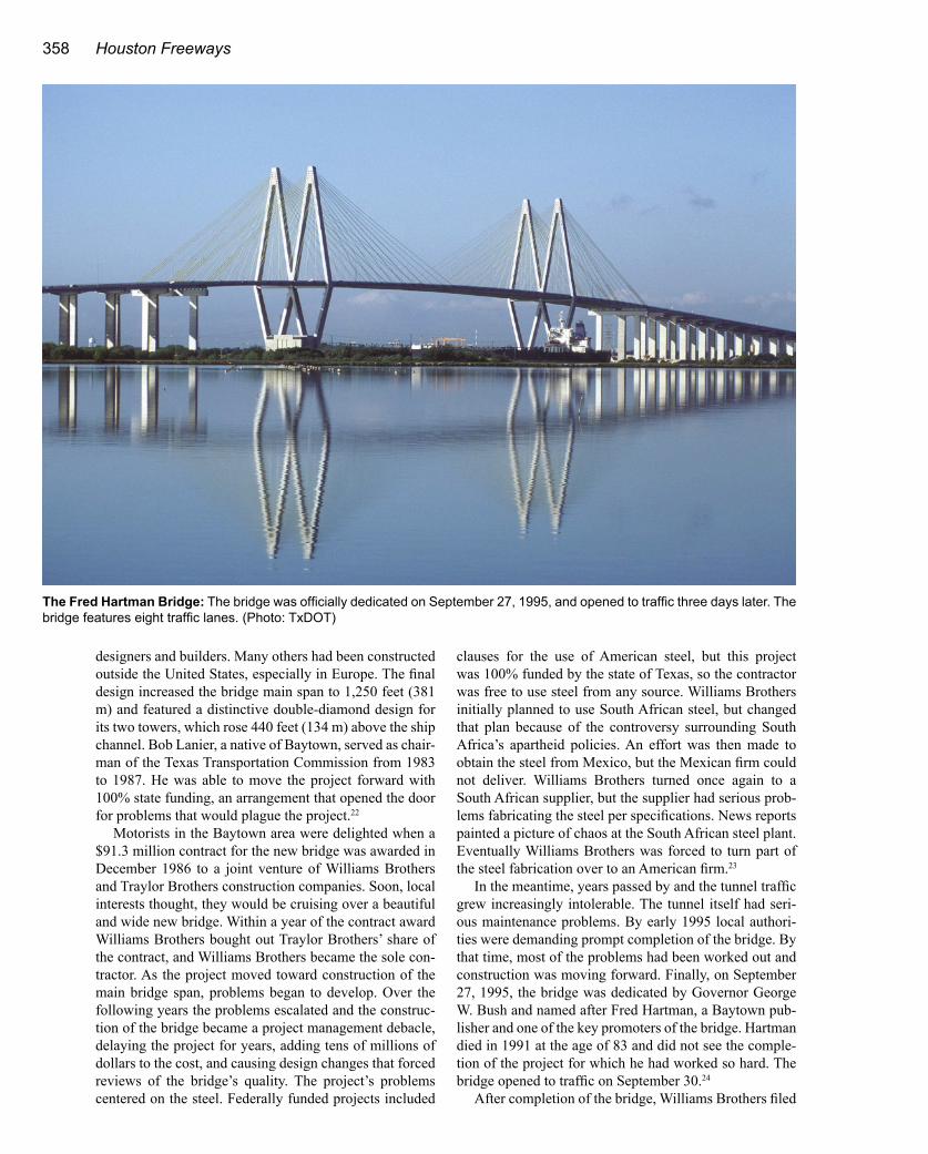
designers and builders. Many others had been constructed outside the United States, especially in Europe. The final design increased the bridge main span to 1,250 feet (381 m) and featured a distinctive double-diamond design for its two towers, which rose 440 feet (134 m) above the ship channel. Bob Lanier, a native of Baytown, served as chair-man of the Texas Transportation Commission from 1983 to 1987. He was able to move the project forward with 100% state funding, an arrangement that opened the door for problems that would plague the project.22
Motorists in the Baytown area were delighted when a $91.3 million contract for the new bridge was awarded in December 1986 to a joint venture of Williams Brothers and Traylor Brothers construction companies. Soon, local interests thought, they would be cruising over a beautiful and wide new bridge. Within a year of the contract award Williams Brothers bought out Traylor Brothers’ share of the contract, and Williams Brothers became the sole con-tractor. As the project moved toward construction of the main bridge span, problems began to develop. Over the following years the problems escalated and the construc-tion of the bridge became a project management debacle, delaying the project for years, adding tens of millions of dollars to the cost, and causing design changes that forced reviews of the bridge’s quality. The project’s problems centered on the steel. Federally funded projects included
clauses for the use of American steel, but this project was 100% funded by the state of Texas, so the contractor was free to use steel from any source. Williams Brothers initially planned to use South African steel, but changed that plan because of the controversy surrounding South Africa’s apartheid policies. An effort was then made to obtain the steel from Mexico, but the Mexican firm could not deliver. Williams Brothers turned once again to a South African supplier, but the supplier had serious prob-lems fabricating the steel per specifications. News reports painted a picture of chaos at the South African steel plant. Eventually Williams Brothers was forced to turn part of the steel fabrication over to an American firm.23
In the meantime, years passed by and the tunnel traffic grew increasingly intolerable. The tunnel itself had seri-ous maintenance problems. By early 1995 local authori-ties were demanding prompt completion of the bridge. By that time, most of the problems had been worked out and construction was moving forward. Finally, on September 27, 1995, the bridge was dedicated by Governor George W. Bush and named after Fred Hartman, a Baytown pub-lisher and one of the key promoters of the bridge. Hartman died in 1991 at the age of 83 and did not see the comple-tion of the project for which he had worked so hard. The bridge opened to traffic on September 30.24
After completion of the bridge, Williams Brothers filed
The Fred Hartman Bridge: The bridge was officially dedicated on September 27, 1995, and opened to traffic three days later. The bridge features eight traffic lanes. (Photo: TxDOT)
Bridges and Tunnels 359
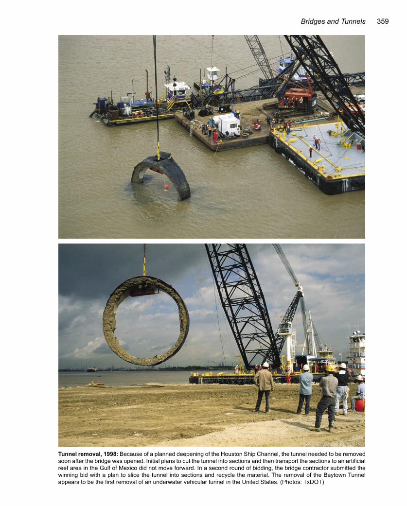
Tunnel removal, 1998: Because of a planned deepening of the Houston Ship Channel, the tunnel needed to be removed soon after the bridge was opened. Initial plans to cut the tunnel into sections and then transport the sections to an artificial reef area in the Gulf of Mexico did not move forward. In a second round of bidding, the bridge contractor submitted the winning bid with a plan to slice the tunnel into sections and recycle the material. The removal of the Baytown Tunnel appears to be the first removal of an underwater vehicular tunnel in the United States. (Photos: TxDOT)

360 Houston Freeways
a $70 million claim with TxDOT for compensation of costs associated with TxDOT errors. A consultant hired to sort out the claim ruled that Williams Brothers deserved most of the blame, but TxDOT bore some responsibility for the problems. The Texas Transportation Commission awarded Williams Brothers a $23.5 million settlement on February 28, 1996. Including an earlier $3 million change order, the total cost of the bridge was $117.5 million, 29% above the original bid.25
The Fred Hartman Bridge features the second longest cable-stayed main span in the United States as of 2003, just behind the 1,300-foot (396 m) Dame Point Bridge in Jacksonville, Florida, and the same length as the Sidney Lanier Bridge in Brunswick, Georgia. It is longer than the well-known Sunshine Skyway Bridge in Tampa, Florida, which has a main span of 1,200 feet (366 m). A surge of bridge construction in Europe and Asia in the 1990s has pushed the Fred Hartman Bridge back to number 32 inter-
nationally, with the 2,920-foot (890 m) Tatara Bridge in Japan taking the honor as the world’s longest cable-stayed span. The Hartman Bridge features two traffic decks, each with four main lanes and both interior and exterior shoul-ders. It is a bridge that any city would love to have in its freeway system, and the crown jewel of Houston’s bridge collection.
The End of the TunnelAccording to the terms of the original agreements to
construct the tunnel, the tunnel and associated buildings would be removed when they no longer carried traffic. Since there were plans to widen and deepen the Houston Ship Channel in the late 1990s, the tunnel removal would proceed promptly.
The tunnel removal appears to be the first and only removal of an underwater vehicular crossing in the United States. The original plan was to cut the tunnel into 350-foot (107 m) sections, float the tunnel sections to the sur-face, and move them to an artificial reef site in the Gulf of Mexico. After a contract award for the reef conversion, complications arose and the project went out for a sec-ond round of bidding. In the second round, the method of tunnel disposal was left up to the contractor. Williams Brothers, the bridge contractor, won with a $17.5 million bid, $4.3 million less than the next lowest bid. Williams Brothers cut the tunnel into sections and recycled the con-crete for use in other road construction projects. So rather than being entombed in the Gulf of Mexico, the tunnel material would wind up in another freeway, a fitting end in Houston.26
Fred Hartman, 1908-1991Fred Hartman was a prominent figure in the
newspaper and publishing industry in the Houston area for more than 50 years, serving as publisher of the Baytown Sun newspaper from 1950 to 1974. He was a community leader and served in various philanthropic organizations. He worked to pro-mote transportation improvements and was a key force in getting the SH 146 bridge built. Fred Hart-man presided over the opening ceremonies of the Baytown Tunnel in 1953, but died in July 1991 be-fore the bridge bearing his name was completed. In an interesting historical curiosity, Hartman was the first boss of Bob Lanier, a native of Baytown who went on to become a leading advocate of transpor-tation improvements in Houston and Texas. In this photo, Fred Hartman participates in the April 18, 1966, dedication of the inner loop section of the East Freeway, the final link connecting Baytown to Houston. Hartman is the third person from the left, wearing a bow tie. Also pictured, from left to right: Eldon Berry, president of the Baytown Chamber of Commerce; Louie Welch, mayor of Houston; Hartman; Earl Caulkins, chairman of the Houston Chamber of Commerce Highway Committee; Herbert Petry, chairman of the Texas Transportation Commission; and V. V. Ramsey, Harris County Commissioner. (Photo: TxDOT)
Key dates in the history of the SH 146 crossing1946 TxDOT approves tunnel and financial agreements.1949 Tunnel construction begins.1953 Baytown Tunnel is dedicated September 22.1967 Efforts begin to construct a bridge.1977 TxDOT authorizes engineering studies for the bridge.1986 Construction contract is awarded.Early1990s
Construction practically stops due to steel fabrication problems.
1995 Bridge is dedicated on September 27.1998 Baytown Tunnel is removed.

Bridges and Tunnels 361
Loop 610 Sidney Sherman BridgeThe Loop 610 ship channel bridge ushered Houston
into the era of high-level spans with its opening on March 2, 1973. With a 152-foot-wide (46 m) deck accommodat-ing 10 traffic lanes, it was an impressive structure. Un-fortunately, one of its other key dimensions—a vertical clearance of 135 feet (41 m)—was not very impressive. The inevitable major collision with an ocean vessel finally occurred 27 years later, only to be followed by an even worse collision just six months later. The bridge remained intact and was repaired in each case. But in 2001 the bridge may have finally earned a reputation as being a bridge too low.
Sidney Sherman BridgeOpened March 2, 1973Type Strutted girderMain span length 600 feet (183 m)Vertical clearance 135 feet (41 m)Width 10 traffic lanes
Full inner and outer shouldersTraffic volume, 2001 122,000 vehicles per dayNamed after Sidney Sherman, colonel in the Republic
of Texas Army, promoter of improvements to the Houston Ship Channel
Future construction None planned
Approach construction: This June 1971 view looking northeast shows the first “V” strut being positioned. (Photo: TxDOT)
��
���
���
�
���
�����
�������
��������
��������
� ������
���� �������
���������������
�������������
������������������
��������������������������

362 Houston Freeways
OriginsThe need for crossings of the Houston Ship Channel
was recognized by local authorities after World War II, and efforts were soon underway to get crossings in place. The immediate need would be satisfied by the Washburn Tunnel, opened in 1950, and the Baytown Tunnel, opened in 1953. These two-lane tunnels provided the needed relief, buying time for the first true freeway crossing over the ship channel. The same year as the opening of the Baytown Tunnel, 1953, officials were preparing Houston’s freeway master plan—a plan which included a full freeway loop and a crossing of the ship channel. By October 1954, the north, south, and west sections of the loop had been adopted into the state highway system, but not the east section which included the ship
channel bridge. Getting the east section adopted into the state highway system and then into the federal Interstate Highway System turned out to be a long, protracted effort for local officials, but by September 1962 the project was fully approved into the interstate system.27
By 1962 engineers at TxDOT had already formulated plans for the crossing. In the interest of saving money, TxDOT planned to make the main span as low and as short as possible with a vertical clearance of 135 feet (41 m) and a horizontal clearance between support piers of only 400 feet (122 m). The Navigation District of the Port of Houston objected to the narrow horizontal clearance, citing it as a navigation hazard, and won a victory when the Army Corps of Engineers rejected the proposed design on November 13, 1963. TxDOT then increased the main
Heavy lifting: A steel girder for the approach span is lifted into position in June 1971. (Photo: TxDOT)

Bridges and Tunnels 363
span to 600 feet (183 m) by using a strutted design with diagonal supports at each end. In early 1964 the Army Corps of Engineers issued a permit for the bridge. There were concerns that a 135-foot vertical clearance might be inadequate, but with the Army Corps approval, TxDOT had the green light to proceed. The final design for the bridge included a deck 152 feet wide (46 m), accommo-dating 10 lanes of traffic. The bridge wouldn’t be high and its span wouldn’t be long, but it would have a very wide deck in comparison to most high-level bridge crossings.28
Major work on the bridge was underway by September 1968. On February 19, 1972, the first girder fully spanning the channel was put into place. As soon as that first girder was in place, officials at the Port of Houston realized that the bridge clearance was going to be a problem. In a March 1972 Houston Post report, the chief engineer for the Port of Houston, Richard P. Leach, called the bridge’s low clearance “a mistake in judgment” and said the bridge would be a navigation hazard. Regarding a possible col-lision between a ship and the bridge, Leach stated, “I always take the view that if something can happen it will happen sooner or later.” Making matters worse were the V-struts at the sides of the span, which provided an even lower clearance for ships veering from the center of the channel. The presiding officer of the Houston Pilots, an association of navigators who guide ships travelling on the channel, lamented, “We protested the vertical clear-ance … but nobody listened to us.” 29
Still, TxDOT officials were confident that the clear-ance would be adequate. And it really was a matter of money. The bridge, as constructed, cost $19 million—ap-
proximately 63 million in 2003 dollars. A bridge with a 150-foot (46 m) clearance would have cost an extra $10 million, according to A. C. Kyser, head of the TxDOT Houston Urban Project Office and a key member of the design team for the bridge. Regarding the clearance, Kyser stated, “In our investigation on the 610 bridge we found that no ships were coming into Houston that needed more than a 120 foot clearance.” Perhaps TxDOT should have been more concerned. After all, it was their bridge, and if it would be struck by a ship, the liability and repair bill could also be theirs.
The 10-lane bridge was completed and opened to traf-fic on March 2, 1973. The bridge was recognized by the National Society of Professional Engineers as one of the nation’s top 10 outstanding engineering achievements for 1972. In 1974 Houston City Council named the bridge the Sidney Sherman Bridge. Sidney Sherman (1805-1873) was a colonel in the Republic of Texas Army and is cred-ited with shouting “Remember the Alamo” during the de-cisive defeat of the Mexican Army at San Jacinto on April 21, 1836. Sherman was instrumental in early efforts to
Key dates in the history of the Sidney Sherman Bridge1953 Houston officials propose a full loop around Houston
as part of a comprehensive freeway plan.1962 The East Loop 610 is adopted into the federal
Interstate Highway System.1969 Construction begins.
1973 The bridge is opened March 2.2000 The first major collision with a vessel occurs.
Closing the span: This view shows placement of the first main span girder for the bridge on February 19, 1972. As soon as this beam was in position, the low clearance of the bridge became painfully clear to officials at the Port of Houston. (Photo: TxDOT)

364 Houston Freeways
make the Houston Ship Channel a navigable waterway.30
A Bridge Too LowIt didn’t take long for ships to strike the bridge. In
fact, it was hit several times during construction, with the bridge structure sustaining minor damage. By 1976 more controversy erupted over the bridge’s low clearance. On June 23, 1976, the Houston Post reported that at least two ships had hit the bridge, causing minor damage. More significantly, a new class of cargo vessel, a roll-on/roll-off design that allowed cargo to be driven on or off the ship, had to be diverted away from the Port of Houston because it would not fit underneath the bridge. Fingers were point-ing at TxDOT. The article quoted a Port of Houston ship
pilot who said of TxDOT, “They knew it was too low when they built the thing. Who would OK a bridge 135 feet high? I don’t know.” The fact was that the Army Corps of Engineers had approved the 135-foot (41 m) clearance, a point that TxDOT emphasized.31
The Loop 610 bridge had luck on its side for its first 27 years. There was one minor collision with an oversized vessel in 1988, but the small hole in the bridge deck was repaired within days. The good luck finally ran out on De-cember 21, 2000. A cargo ship’s crane struck the bridge, tearing out a large hole in the concrete deck, severely damaging one steel beam underneath the deck and moder-ately damaging another steel beam. Repair took about six weeks. Three northbound lanes were closed for the entire period, and other major bridge closures were required to make the repair. On May 31, 2001, a freighter’s cargo boom struck the bridge, punching another hole in the pavement and causing a bridge girder underneath the deck to sustain extensive damage. Repairs would cost $1.25 million, require two months, and close four of the five northbound lanes. By that time, Houston motorists were hoping for another 27-year run of good luck.32
“They knew it was too low when they built the thing. Who would OK a bridge 135 feet high? I don’t know.”
Port of Houston pilot quoted in the Houston Post, June 23, 1976
Collision: On December 21, 2000, a crane on a cargo ship struck the bridge, causing this large hole in the bridge deck. No vehicles fell through the hole, and there were only three minor injuries. Most of the damage occurred to the bridge substructure underneath the deck. Five months later another major collision caused even more extensive damage to the bridge girders. (Photo: TxDOT)

Width is good: The bridge features a deck 152 feet (46 m) wide to accommodate 10 traffic lanes. This view looks south. (Photo: July 2002)
Height is bad: This view looks east along the Houston Ship Channel at the Sidney Sherman Bridge. The 135-foot (41 m) vertical clearance of the bridge caused controversy in the bridge’s early years and eventually resulted in collisions with vessels. (Photo: September 2002)
366 Houston Freeways
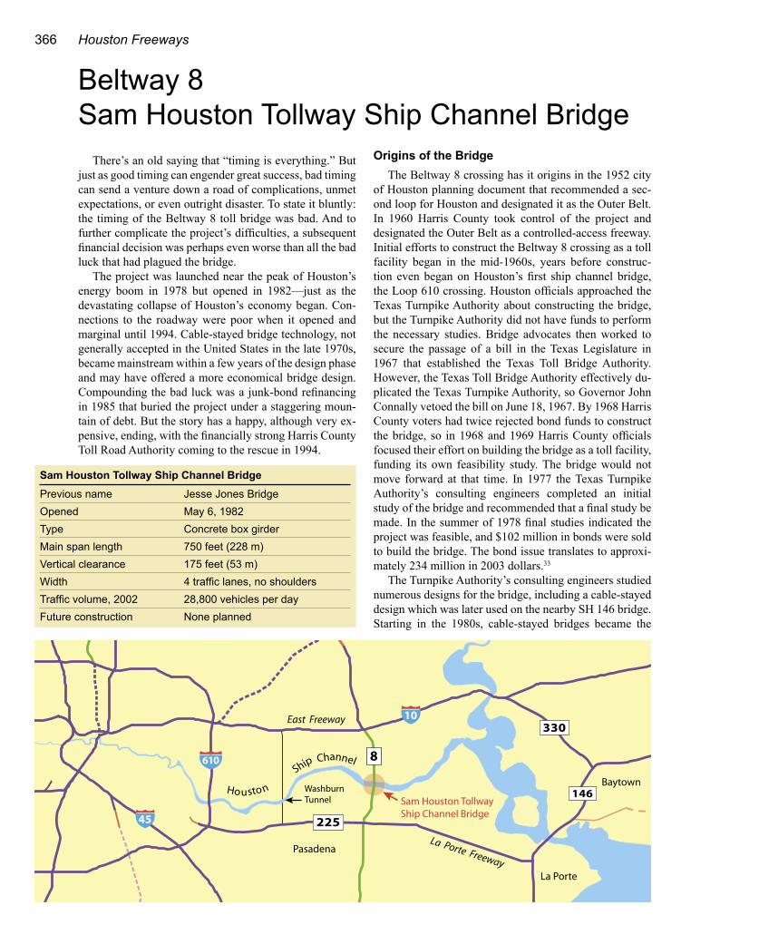
Beltway 8 Sam Houston Tollway Ship Channel Bridge
There’s an old saying that “timing is everything.” But just as good timing can engender great success, bad timing can send a venture down a road of complications, unmet expectations, or even outright disaster. To state it bluntly: the timing of the Beltway 8 toll bridge was bad. And to further complicate the project’s difficulties, a subsequent financial decision was perhaps even worse than all the bad luck that had plagued the bridge.
The project was launched near the peak of Houston’s energy boom in 1978 but opened in 1982—just as the devastating collapse of Houston’s economy began. Con-nections to the roadway were poor when it opened and marginal until 1994. Cable-stayed bridge technology, not generally accepted in the United States in the late 1970s, became mainstream within a few years of the design phase and may have offered a more economical bridge design. Compounding the bad luck was a junk-bond refinancing in 1985 that buried the project under a staggering moun-tain of debt. But the story has a happy, although very ex-pensive, ending, with the financially strong Harris County Toll Road Authority coming to the rescue in 1994.
Origins of the BridgeThe Beltway 8 crossing has it origins in the 1952 city
of Houston planning document that recommended a sec-ond loop for Houston and designated it as the Outer Belt. In 1960 Harris County took control of the project and designated the Outer Belt as a controlled-access freeway. Initial efforts to construct the Beltway 8 crossing as a toll facility began in the mid-1960s, years before construc-tion even began on Houston’s first ship channel bridge, the Loop 610 crossing. Houston officials approached the Texas Turnpike Authority about constructing the bridge, but the Turnpike Authority did not have funds to perform the necessary studies. Bridge advocates then worked to secure the passage of a bill in the Texas Legislature in 1967 that established the Texas Toll Bridge Authority. However, the Texas Toll Bridge Authority effectively du-plicated the Texas Turnpike Authority, so Governor John Connally vetoed the bill on June 18, 1967. By 1968 Harris County voters had twice rejected bond funds to construct the bridge, so in 1968 and 1969 Harris County officials focused their effort on building the bridge as a toll facility, funding its own feasibility study. The bridge would not move forward at that time. In 1977 the Texas Turnpike Authority’s consulting engineers completed an initial study of the bridge and recommended that a final study be made. In the summer of 1978 final studies indicated the project was feasible, and $102 million in bonds were sold to build the bridge. The bond issue translates to approxi-mately 234 million in 2003 dollars.33
The Turnpike Authority’s consulting engineers studied numerous designs for the bridge, including a cable-stayed design which was later used on the nearby SH 146 bridge. Starting in the 1980s, cable-stayed bridges became the
Sam Houston Tollway Ship Channel BridgePrevious name Jesse Jones BridgeOpened May 6, 1982Type Concrete box girderMain span length 750 feet (228 m)Vertical clearance 175 feet (53 m)Width 4 traffic lanes, no shouldersTraffic volume, 2002 28,800 vehicles per dayFuture construction None planned
��
���
���
�
���
�����
�������
��������
��������
�� ���� �
���� �������
���������������
�������������
������������������
��������������������������������������

Bridges and Tunnels 367
design used most frequently for spans of this length. In 1978 only one major cable-stayed span had been constructed in the United States, the 750-foot (229 m) Pasco-Kennewick span in Washington State. The consultant’s cost estimate reflected the lack of familiarity among U.S. con-struction firms with the construction techniques required to build cable-stayed spans and the en-gineering difficulty in analyzing the structures, since analytical tools were not yet available. Consequently, the cable-stayed design was esti-mated to be 15% more expensive than the most economical design, the concrete box girder.34
The plans for the concrete box girder bridge included a main span of 750 feet (229 m), a ver-tical clearance of 175 feet (53.3 m), and a total bridge length of 2.0 miles (3.2 km). At the time it was the longest concrete box girder span in the Western Hemisphere and the fifth longest in the world.* Construction was underway by 1979 and progressed well. The bridge, originally named the Jesse Jones Ship Channel Bridge, was opened to traffic on May 6, 1982. Jesse Jones (1874-1956) was probably the most influential individual in the development of Houston into a major city. He played an important role in the 1910 deepening of the ship channel by persuading Houston banks to purchase $1.25 million in Harris County port improvement bonds that previously could not find any buyers.35
The Financial Woes BeginTraffic volume on the new bridge immedi-
ately fell below projections. In 1982, projected traffic volume was 4 million vehicles, but actual traffic volume was only 1.69 million vehicles, 42% of the projection. At the end of 1983 the annual report of the Texas Turnpike Authority first reported on the traffic shortfall, attributing the lack of traffic to the delay in completion of the connections to the bridge. Moody’s Investors Service revised the bond rating to “B,” which is one level below the rating of the highest rated junk bonds, “Ba.” 36
In 1984, interchanges at the north and south ends of the Beltway 8 segment including the bridge were completed, but traffic increases were not suf-ficient to generate enough revenue to service the debt. The 1984 annual report of the Texas Turnpike Authority stated that “the lack of adequate revenue stems from the lack of adequate connections to US 90 at the north and IH 45 at the south, combined with a general recession in the Hous-ton ship channel area economy.” By May 1985 Merrill Lynch, principal underwriter of the bonds, was warning of
a possible default. In July 1985 Governor Mark White sent the Texas Turnpike Authority a letter urging the agency to “take all necessary action to avoid the possible default on these bonds.” That’s exactly what the agency did, but the price for avoiding default would be very, very high.37
The bridge debt was refinanced with a $27.9 million junk bond issue in December 1985. The terms of the junk bonds were indicative of just how risky this proposition
Pier construction: This 1980 photograph shows the piers for the main span taking shape. The reason for calling this type of bridge a concrete box girder can be seen in this photo. The “box” is the cross section of the bridge’s main span, visible at the top of the pier. In this bridge the box actually has the shape of a trapezoid. (Photo: North Texas Turnpike Authority)
* The Confederation Bridge at Prince Edward Island, Canada, with 43 820-foot (250 m) spans, displaced the Beltway 8 bridge as the longest concrete box girder span in the Western Hemisphere in 1997. After a surge of bridge construction in Europe and Asia in the 1990s, the bridge span no longer ranks in the top 20 internationally. The Stolmasundet Bridge in Norway, with a 988-foot (301 m) span, is the world’s longest concrete box girder.

368 Houston Freeways
was. The interest rate was 12.625%, and no payments of interest or principal would be made for 10 years. The junk bond refinancing bought the authority time, but amounted to a huge bet that traffic and toll revenue would dramati-cally increase in the future.
The long-term financial implications of the junk bonds were staggering. With no payments for 10 years, the $27.9 million would grow to $95.6 million by 1996 when in-terest payments would begin. Over its total life through
the year 2020, the $27.9 million junk bond issue would require $332 million in debt service payments. Prior to the junk bond financing, the 1984 annual report of the Texas Turnpike Authority listed total debt service obligations of the bridge at $223 million. After the junk bond financing in 1985, total obligations increased to $522 million.
But perhaps most financially devastating was the clause in the agreement that prevented repayment until July 1, 2002. This meant that the Texas Turnpike Author-ity was liable for $175.8 million in payments on the $27.9 million bond issue, with no option to call (refinance) the bonds. Only those closely involved with the junk bond market in 1985 may really know if such unfavorable bond terms were in fact necessary to obtain the financing. Perhaps the decision makers were content to pass this li-ability on to the next generation of politicians. Someone else would be in charge when the cards would be turned over on this huge bet.
Authorities would not have to wait until 1996 to know if their bet would succeed or fail, however. Toll-paying traffic on the bridge increased nicely over the next few years but at nowhere near the rate required to meet the obligations of the junk bonds. From 1989 to 1993, bridge patronage remained flat at about six million vehicles per year, generating approximately $10 million per year in revenue. This just met the $9.4 million annual obligation on the original bonds, but in 1996 annual payments of $12
A mountain of junk bond debtThe 1985 junk bond refinancing of the toll bridge was financially devastating and practically guaranteed a default or costly bailout when the first junk bond payment came due in 1996. (values in millions of dollars, except interest rates)Original bond issue, 1978 102Interest rate 7.54%Total debt service, interest and principal, 1984 223Junk bond financing, December 1985 27.9Interest rate 12.625%Junk bond total debt service 332Junk bond minimum liability, based on earliest bond refinance date of July 1, 2002 176
Total debt service, interest and principal, end of 1985 522
Building a concrete box girder bridge: This photograph taken near the end of 1981 shows the bridge main span about 75% complete. This view also illustrates the construction technique used for a concrete box girder bridge. The “box” is actually the hol-low, rectangular cross section of the main bridge span. After the bridge support towers are constructed, the bridge deck is gradu-ally built outwards from the towers in both directions to maintain balance. Each additional section of the bridge is “post-tensioned,” meaning that cables are used to put squeezing pressure, or compression, on the concrete. Concrete is strong in compression but weak when it is pulled on (in tension). The two sides meet in the middle, connecting the bridge sections. (Photo: North Texas Turnpike Authority)

Bridges and Tunnels 369
million per year would begin on the junk bonds. Default was a certainty if a bailout did not occur. But the savior of the Beltway 8 bridge would soon step forward.38
BailoutWhile the Texas Turnpike Authority’s Beltway 8
bridge had turned into a financial disaster, the Harris County Toll Road Authority (HCTRA) was faring much better. Although HCTRA’s Hardy Toll Road was also a financial underperformer, the Sam Houston Tollway had been phenomenally successful and had become a cash cow for the agency. HCTRA was formulating plans to expand its tollway network and there would be more bond issues in the future. A default on the Beltway 8 bridge had the potential to tarnish the image of Harris County in the eyes of bondholders, and this would result in higher inter-est rates and much higher costs in the long run.
Harris County Judge Jon Lindsay took the lead in negotiating the bailout, which turned out to be no easy task. Work on the bailout began in 1992. A ruling from the Texas attorney general’s office in 1992 stated that existing state legislation did not sufficiently define if the
Spanning the channel: This view looks east at the Sam Houston Tollway Ship Channel Bridge. (Photo: September 2002)
Traffic builds: Since the Harris County Toll Road Authority took ownership of the bridge in 1994, traffic volume has increased from 16,100 vehicles per day to 28,800 vehicles per day in 2002, a slight drop from the 2001 peak of 29,300 vehicles per day.
�
��
��
��
��
��
��������������������
���������������������
����������������������������������� ��������������������������������������������������������������

370 Houston Freeways
bridge could be transferred to Harris County. In May 1993 the Texas Legislature approved legislation permitting the transfer. Finally in 1994, everything was in place to make the bailout, and the official transfer occurred on May 5, 1994. Default was avoided, and the bridge became part of the Harris County toll road system. Surely with a big sigh of relief, the Texas Turnpike Authority stated in its 1994 annual report, “The Authority no longer has any financial obligation related to the bridge.” 39
But there was one expensive complication. Under the terms of the 1985 junk bonds, the earliest repayment date was July 1, 2002. The bondholders could have agreed to an earlier repayment, but once they realized that HCTRA had sufficient resources to pay interest through 2002, the bondholders would not compromise on the original terms. This meant an additional eight years of interest at an an-nual rate of 12.625% would have to be paid, amounting
to $12.1 million per year. But HCTRA had no choice—it had to pay.40
Why was HCTRA paying $225 million for a bridge that was generating about $10 million per year in rev-enue? Avoiding a default was one reason. Harris County also managed to negotiate some very attractive incentives for HCTRA. As part of the deal, TxDOT agreed to con-tribute $90 million towards the construction of the south Sam Houston Tollway between the bridge and the South-west Freeway, and to spend $120 million on interchanges at the Gulf and Southwest Freeways. The deal sweeteners made it possible to complete nearly all of Beltway 8 as a tollway. In May 1997 the south Sam Houston Tollway was completed. By 2002 bridge traffic volume had increased to 10.5 million vehicles per year, or 28,800 vehicles per day. At an average toll of approximately $2 per vehicle, this translated to a revenue stream of about $20 million per year, bringing the bridge revenue into the range need-ed to cover bond payments.41
The Beltway 8 ship channel bridge was perhaps a bridge that should not have been built. Surely, the timing was wrong when it was completed in 1982. As with any project where there is no obvious answer on whether or not to build, there is risk. But the Houston philosophy of building to meet future growth has always served it well, in spite of this one financial debacle. Because of the deci-sion to build in 1978, Houston has a distinctive structure in its collection of bridges. Compared to the nearby SH 146 cable-stayed bridge, the Beltway 8 bridge is under-stated and modest. It is a product of its time in history, a window where the concrete box girder structure was the superior design.
Key dates in the history of the Beltway 8 bridge1952 Beltway 8 is first proposed.1960s Harris County unsuccessfully tries to construct the
bridge.1977 Studies declare the project feasible as a toll bridge.1978 $102 million in bonds are sold. Construction begins.1982 The bridge opens May 6.1985 Bridge is refinanced with $27.9 million in junk bonds.1994 On May 5 the Harris County Toll Road Authority takes
ownership of the bridge and assumes all debt.2003 The bridge is near or has reached financial self-
sufficiency, based on originally scheduled bond payments.

Bridges and Tunnels 371
The Unbuilt: Galveston-Bolivar CrossingIn Houston, the list of projects that fall into the “un-
built” category is small and continues to become smaller as time passes. There remains only one large bridge proj-ect on that list: the Galveston-Bolivar crossing. But some-time before 2010, there is a good chance that this final ma-jor bridge crossing in the Houston area will be scratched off the unbuilt list, and an impressive new high-level span will rise on the east end of Galveston Island. Previous efforts to construct the crossing started in the 1940s but have been unsuccessful, primarily due to the low traffic volume and high cost. But this time things may be differ-ent because of advancing bridge construction technology. Cable-stayed designs have become very economical for crossings of this length and height. The advancing tech-nology has unleashed a wave of major bridge construction in Japan, Asia, and Europe. The United States has mostly been on the sidelines for the 1980s and 1990s worldwide bridge construction boom, mainly because most needed crossings in the United States have long been constructed. The forces that have made so many bridges around the world feasible may finally make even the most marginal of projects, such as the Galveston-Bolivar crossing, a reality.
If built, the Galveston-Bolivar crossing will not be a record-setting span. Its main cable-stayed span, recom-mended to be a minimum of 1,100 feet (335 m), will be among the longest in the United States. The span length will be similar to the Fred Hart-man Bridge on SH 146, but will be in the middle of the pack by worldwide standards. The vertical clearance, however, recom-mended to be 220 feet (67 m), will be among the tallest in the world.
The Galveston-Bolivar crossing has al-ways presented some serious challenges to a fixed crossing. The Houston, Texas City, and Galveston ship channels all pass through the gap between Galveston Island and Bolivar Peninsula, providing heavy ocean vessel traf-fic. Most significant is the need to bring jack-up offshore drilling rigs into the Galveston Ship Channel. These structures are typically 250–350 feet high (76–107 m) and can ex-ceed 400 feet (122 m) in height on the larger units. Strong currents exist in this area, since the entire Trinity and Galveston Bay waters are connected to the Gulf of Mexico through this location.42
Low traffic volume and high bridge cost have always diminished the cost effective-ness of a fixed crossing. In the late 1990s an average of approximately 5,800 vehicles per day used the ferry service. The ferry traffic is highly seasonal, with summer weekend
patronage between 9,000 and 10,000 vehicles per day and winter weekday patronage in the 4,000-5,000 range. Ferry service is normally adequate, but during busy summer weekends waiting time can exceed two hours.
History of the Bolivar CrossingPrivate operators began $1 toll ferry service in 1929
using the vessels Galveston and Jefferson. The ferries were purchased by Galveston County at the end of 1929, and were subsequently sold to TxDOT in April 1930. TxDOT took over ferry operation in July 1934 and kept the original vessels in service until 1950 when they were replaced by new ferries.
In 1944 Galveston County officials recognized the
Proposed Galveston-Bolivar crossingDesign type Cable-stayedMain span At least 1,100 feet (335 m)Total length Approx. 2.5 miles (4 km)Vertical clearance 220 feet (67 m)Traffic lanes 4Deck width 85 feet (26 m)Estimated construction cost (2000) $211 millionData: SH 87 Feasibility Study, TxDOT, November 2000
���������
�������
������������
��������������
����������������
��������������
�������������
372 Houston Freeways
need for improved service between Galveston and Bolivar Peninsula and began efforts to construct a fixed cross-ing. In July 1944 Galveston County filed an application with the Texas Transportation Commission for aid in the construction of a tunnel. The commission authorized ex-tensive studies, and on May 15, 1946, it submitted three different proposals to Galveston County officials for im-provement of the Bolivar crossing. The commission and Galveston County could not agree on terms for the tunnel construction, so on January 22, 1947, the commission submitted a final offer of three options. In option one, TxDOT would provide $5 million in funds for a toll-free tunnel with the remaining funding to be provided by Galveston County. The commission had recently agreed to contribute an estimated $5 million to the construction of the nearby Baytown tunnel, with the Port of Houston contributing the remaining $2.9 million to complete the estimated $7.9 million project, which had a final cost of $8.7 million. For option two, TxDOT would modernize the ferry service at its own expense. In the third option, TxDOT would participate in a toll tunnel, contributing annual funding in the amount of the cost of ferry service. Galveston County did not take action on the proposal, and
the offer for state participation in the tunnel was officially rescinded in September 1948. The Texas Transportation Commission then authorized the construction of two new ferry boats, the Ross Sterling and Cone Johnson, to re-place the old Galveston and Jefferson ferries. Tolls for the ferry service were removed when the new ferries began operating in 1950. A third vessel, the E. H. Thornton Jr., was commissioned into service in early 1959.43
In the late 1960s interest in the Bolivar crossing was revived. In response to a request from Galveston County, the Texas Transportation Commission authorized a study in 1968. In November 1968 the study found that a four-lane bridge with a 1,140-foot (347 m) main span and a vertical clearance of 138 feet (42 m) would cost an estimated $30 million—approximately 126 million in 2003 dollars. In July 1969 the commission indicated it could justify an expenditure of $25 million, with Galves-ton County paying the remaining $5 million. The 1969 Galveston County Transportation Plan included the crossing in its long-range recommendation. Concerns over possible bridge interference with maritime industries forced a reevaluation of the proposed bridge clearance in late 1969. In January 1972 the commission authorized a
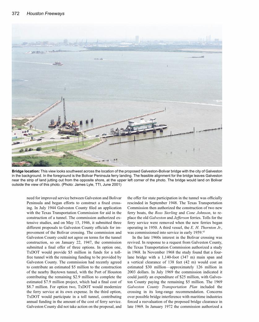
Bridge location: This view looks southwest across the location of the proposed Galveston-Bolivar bridge with the city of Galveston in the background. In the foreground is the Bolivar Peninsula ferry landing. The feasible alignment for the bridge leaves Galveston near the strip of land jutting out from the opposite shore, at the upper left corner of the photo. The bridge would land on Bolivar outside the view of this photo. (Photo: James Lyle, TTI, June 2001)

Bridges and Tunnels 373
new study of the crossing. The study was completed in September 1973. A fixed crossing was ruled infeasible, mainly because of rapidly escalating costs, and the com-mission reported that “construction of a bridge or tunnel is not economically feasible at present or in the foreseeable future.” The commission authorized improvements to the ferry service, including the purchase of an additional ferry boat. As the highway funding financial crisis escalated during the 1970s, any thought of building a fixed span had just about vanished.45
The ferry service operated by TxDOT was enhanced and by the mid-1990s there were six ferry boats, with up to five in service at any given time, and two landings at each end of the ferry route. Still, the ferry became known for lengthy delays during peak travel times, especially during summer weekends when waits often exceeded two hours. Heavy traffic was generated by the teenage and young adult crowds who favored the beaches on Bolivar Peninsula because of the lack of restrictions on alcohol. The ferry service was always susceptible to weather-re-lated disruptions. A report prepared for TxDOT in 1996 by
the Texas Transportation Institute identified future capital improvements that would be required for the ferry system, forecasted future traffic growth, and estimated operating costs. The 1996 study also recommended a feasibility study to determine if the ferry system could be replaced by a bridge or tunnel. The SH 87 feasibility study began in 1999 and was completed in November 2000.
The Bridge Gets New LifeThe 2000 study looked at all possibilities, including
improving the ferry service, building a bridge or tunnel on four possible crossing locations, or doing nothing. The four potential crossing locations included two from the eastern end of Galveston Island, one from Pelican Island (just north of Galveston Island), and one from the main-land at Texas City.
The conclusion: a bridge option is feasible and has a total cost comparable to the cost of needed ferry service improvements. The feasible bridge option was the route from Pelican Island, an alignment which does not obstruct the entrance to the Galveston Ship Channel. The bridge
Some things change, some things remain the same: This photo from circa 1950 shows the ferry landing at Bolivar Peninsula. Ferry facilities have been expanded and improved continuously since TxDOT began the modern ferry operation in 1950. But one thing hasn’t changed: teenagers and beach party-seekers go to Bolivar Peninsula looking for action, as these teenagers in the convertible were in 1950. In the 1990s a two-mile stretch of beach at the community of Crystal Beach became known as the “zoo” for its rowdy crowds and party atmosphere.44 (Photo: TxDOT)

374 Houston Freeways
cost was estimated to be $211 million, and its total cost, including improvements to access roadways from IH 45, was $243.5 million. The ferry service option needed to meet future needs was estimated to cost $207.6 million. The cost of the tunnel options was in the range of $1.1 to $1.3 billion. The crossings from the eastern end of Galveston Island would have blocked jack-up oil plat-forms from entering the Galveston Ship Channel, render-ing those crossing locations infeasible. The Texas City route would have required a long earthfill project along the Texas City Dike to widen it for a new access road, and the bridge would have been very close to the intersection
of the Texas City and Houston Ship Channels, where cur-rents provide hazardous navigation conditions.
The report recommended a cable-stayed main span with a minimum length of 1,100 feet (335 m). For com-parison, the nearby SH 146 Fred Hartman Bridge has a main span of 1,250 feet (381 m). The longest cable-stayed bridge in the United States in 2003 has a main span of 1,300 feet (396 m). The longest cable-stayed span in the world in 2003 has a main span of 2,920 feet (890 m), and the world’s longest bridge, a suspension bridge, has a main span of 6,532 feet (1991 m). But the proposed bridge will rank among the world’s best in terms of verti-cal clearance. The bridge study carefully investigated the height above water (“air draft”) of ships in the world’s maritime fleet and attempted to anticipate the future required clearance to ensure the bridge will not restrict waterborne commerce. Perhaps the study authors recalled the controversy surrounding the low, 135-foot (41 m) clearance of the Loop 610 bridge and the limitations it imposed. Within months of completion of the study, there were two major collisions between the Loop 610 bridge and oversized vessels.
The report found that the ocean vessels with the largest air drafts were cruise ships. The tallest vessel identified in the Gulf of Mexico-Caribbean region had an air draft of 228 feet (69 m). An air draft of 208 feet (63 m) seemed to be more typical of the biggest existing and planned cruise ships. The tallest cargo-container vessel identified had an air draft of 180 feet (55 m), and a height of 165 feet (50 m) was determined to be typical of the tallest anticipated future vessels. The recommended vertical clearance for
Key dates in the history of the Galveston-Bolivar crossing1929 Private ferry service is started. Ferries are purchased
by Galveston County at the end of the year and then sold to TxDOT in 1930.
1944 Galveston County officials begin efforts to get a tunnel built.
1948 Consideration of a tunnel ends. TxDOT agrees to modernize the ferry service.
1950 New ferries begin toll-free ferry service.
1968 Galveston County officials begin efforts to construct a bridge.
1973 A bridge is declared infeasible. Ferry service is improved.
1990s Long waiting times for ferry service at peak periods.
2000 A study determines that a bridge crossing is feasible.
2005- 2010
Possible construction of new bridge.
Alternatives studied:This map shows the crossing routes that were studied in the 1999-2000 study. The red and purple options from the east end of Galveston Island were infeasible because they would have blocked offshore jack-up rigs from entering the Port of Galveston. The routes from the mainland via the Texas City Dike were infeasible due the cost of widening the dike and navigation issues at the cross-ing location. A bridge cross-ing on the blue alignment via Pelican Island was determined to be feasible. (Source: SH 87 Feasibility Study, TxDOT)

Bridges and Tunnels 375
the proposed Bolivar bridge is 220 feet (67 m), which places it in the range of some of the world’s tallest and best-known crossings, including the Golden Gate Bridge (220 feet, 67 m), the Verrazano Narrows Bridge in New York City (229 feet, 70 m), the Great Belt Bridge in Den-mark (213 feet, 65 m), and the Akashi-Kaikyo Bridge in Japan (220 feet, 67 m). Even so, in early 2003 the Port of Houston was against a bridge with a 220-foot clearance, citing it as a potential navigation hazard. The proposed 85-foot-wide (26 m) bridge deck will support four traffic lanes and full shoulders. The total length of the proposed bridge is approximately 2.5 miles (4 km).46
The report studied the feasibility of using tolls to de-fray part of the cost of the bridge and concluded that toll financing was a viable option. In June 2001, the Harris County Toll Road Authority (HCTRA) released a map showing potential future toll projects in the Houston area.
Included in the map is the Bolivar crossing. In December 2001, the Texas Transportation Commission authorized TxDOT to enter into negotiations with HCTRA for the bridge construction. Legislation passed in the 2003 Texas legislative session resolved legal issues relating to HC-TRA’s building a project in Galveston County, removing a potential roadblock to the project.47
Will the Galveston-Bolivar bridge be built? Only time will tell. The project seems to be closer to moving for-ward than at any other time in its history. The possibility of industrial development on Pelican Island, the Galves-ton-side bridge location, will likely influence whether the bridge is built. The potential for an all-new, high-level crossing is something that few cities in the United States can look forward to. The Houston area may get one before 2010.
June 2005 Update: The crossing remains under study in June 2005, with no movement toward construction. In 2004 work began on an additional ferry landing and the addition of a new ferry vessel, which will likely postpone the need for a bridge.
Making a Jeffersonian crossing: These photos show the Jefferson, one of the two ferries which provided service between Galveston and Bolivar Peninsula from 1929 to 1950. The Jefferson and Galveston were retired in 1950 when the Ross Sterling and Cone Johnson entered service. (Photos: TxDOT)