BRIDGER-TETON NATIONAL FOREST - … NATIONAL FOREST ... Roadless areas were identified during the...
76
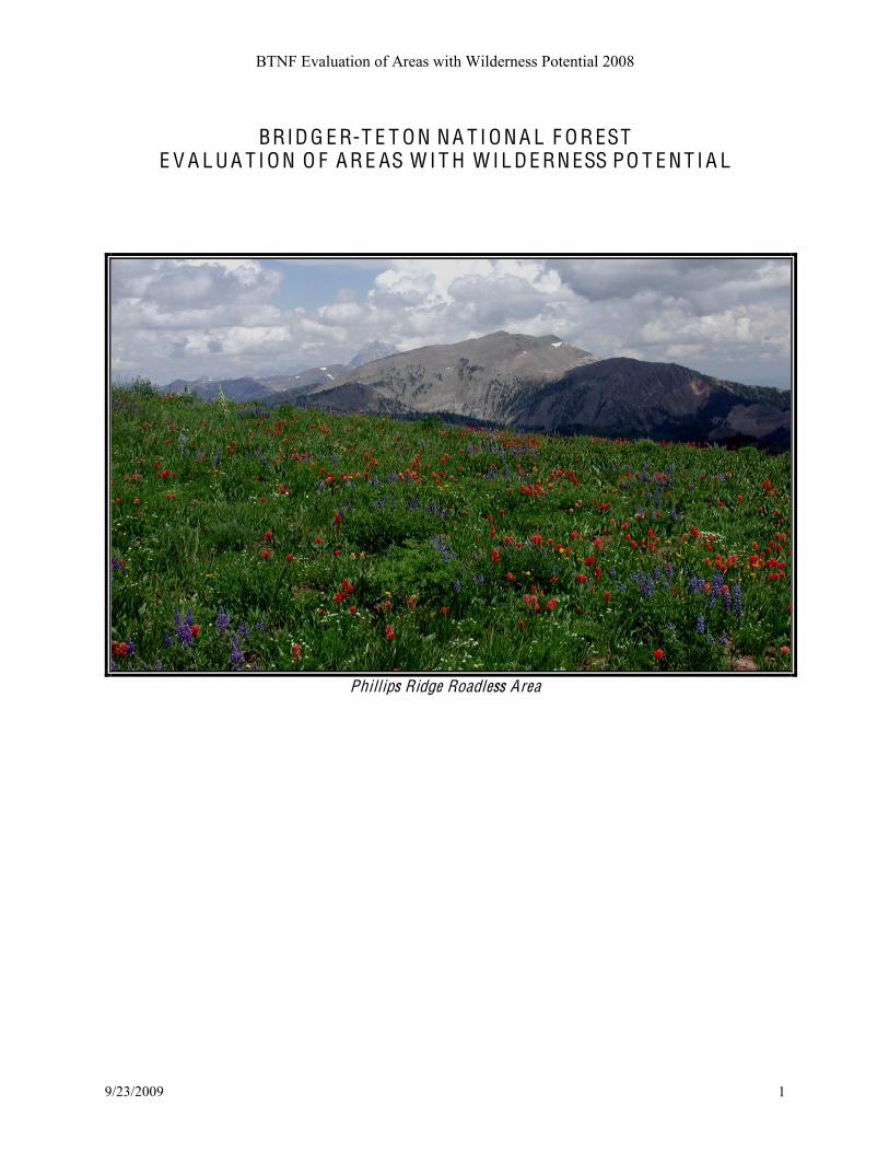
BTNF Evaluation of Areas with Wilderness Potential 2008 9/23/2009 1 BRIDGER-TETON NATIONAL FOREST EVALUATION OF AREAS WITH WILDERNESS POTENTIAL Phillips Ridge Roadl ess Ar e a
-
Upload
truongxuyen -
Category
Documents
-
view
215 -
download
0
Transcript of BRIDGER-TETON NATIONAL FOREST - … NATIONAL FOREST ... Roadless areas were identified during the...
BTNF Evaluation of Areas with Wilderness Potential 2008
9/23/2009 1
BRID G E R-T E T O N N A T I O N A L F O R EST E V A L U A T I O N O F A R E AS W I T H W I L D E RN ESS PO T E N T I A L
!Phillips Ridge Roadless Area

C O N T E N TS
Introduction ..................................................................................................................................2
The 2001 roadless rule, areas with wilderness potential, and process for integration .................2
Capability factors defined ............................................................................................................4
Availability defined .....................................................................................................................9
Need defined ................................................................................................................................9
BTNF areas with wilderness potential .........................................................................................11
Eligibility factors by area .............................................................................................................15
Summary of capability factors .....................................................................................................68
Areas with Wilderness potential and Forest Plan revision ..........................................................70
IN T R O DU C T I O N
Roadless areas were identified during the Roadless Area Review and Evaluation II (RARE II)
analysis conducted in 1978 and re-evaluated in 1983 to include all areas of at least 5,000 acres
without developments and substantially natural in character. The RARE II and subsequent
roadless area inventories and evaluations identified twenty roadless areas on the forest. In 1984
with the passage of the Wyoming Wilderness Act, most of the Gros Ventre roadless area became
the Gros Ventre Wilderness and Shoal Creek Wilderness Study Area; another became the
Palisades Wilderness Study Area.
Natural areas without roads or developments contribute to the BTNF!"#niche, character and sense
of place; they possess attributes of public interest that do not necessarily have to do with their
potential as wilderness; the state of $roadlessness! is valuable for recreation as well as its
influence on clean water and healthy watersheds, wildlife habitat, and biodiversity, among other
attributes. The purpose of this evaluation is not to determine the best future management of
undeveloped lands across the BTNF, but only to determine which, if any, of the areas of
potential wilderness will be recommended to Congress for future designation. Areas not
recommended may still be managed under forest plan direction as unroaded backcountry.
T H E 2001 R O A D L ESS RU L E A ND A R E AS O F PO T E N T I A L W I L D E RN ESS
Under the Roadless Area Conservation Rule of 2001 inventoried roadless areas of record were
fixed in time and place. National forest policy related to this rule holds that inventoried roadless
areas contain important environmental values that warrant protection. Accordingly, until a forest-
scale roads analysis is completed and incorporated into a forest plan, inventoried roadless areas
shall, as a general rule, be managed to preserve their roadless characteristics. However, where a
line officer determines that an exception may be warranted, the decision to approve a road
management activity or timber harvest in these areas is reserved to the Chief or the Regional
Forester. On a project-specific basis, the Chief, for good cause, may grant exceptions to the
reservations of authority upon the written request of a Regional Forester or Forest Supervisor.
This has never occurred on the BTNF.

BTNF Evaluation of Areas with Wilderness Potential 2008
9/23/2009
The BTNF has identified areas within the forest that might be potential additions to the national
wilderness preservation system. These are called A R E AS O F PO T E N T I A L W I L D E RN ESS instead of
$roadless!#%&'%" to avoid confusion between those areas legally bound by the 2001 rule and those
that result from the updated and corrected maps of forest roads and trails. Three primary data
layers were used to conduct the initial screening: (1) all BTNF lands outside of existing
wilderness; (2) all forest system roads managed by the BTNF as open roads or gated and used
administratively; and (3) facilities such as campgrounds, summer home areas, etc.
The inventory mapping process used is a two-step process.
Step 1 - GIS rendering
of polygons that meet
the wilderness potential
criteria for size, absence
of roads, and human
impacts.
Overlay roads layer and facilities layer to create a base map.
Apply size criteria to the polygons to determine which are greater
than 5000 acres. Review polygons less than 5000 acres as needed
to determine if they potentially qualify for further wilderness
potential consideration. Include as appropriate.
Identify and attribute all polygons that will be considered for
further wilderness suitability analysis.
Final product = map of areas with wilderness potential.
Step 2 - Refinement of
the GIS polygons.
Clean up the polygons to remove areas which do not meet the
intent of the wilderness potential criteria, such as narrow fingers,
heavily roaded areas which create ameoba-like polygons, and
other appendages, intrusions, and extensions.
Describe all rationale for excluding areas from the roadless
inventory.
Final product = areas identified for consideration as potential
wilderness).
Areas of potential wilderness that will be identified for future recommendation to Congress are
to be managed for desired conditions aimed at preserving wilderness characteristics, with the
following guidance:
! Motorized or mechanical transportation uses, as indicated in existing travel plans,
are allowed only if they do not compromise wilderness values.
! New roads or trails for motorized or mechanical transportation are prohibited.
! Mechanical vegetation treatments that would compromise wilderness values are
prohibited.
! Per the March 2006 Memorandum of Understanding between the Forest Service
and the State of Wyoming, areas are unavailable for new oil and gas leases until
forest plans are revised and leasing availability decisions are completed.
! Improvements to trails are allowed only if they do not compromise wilderness
values.
! New or expanded recreation uses, including special uses, are allowed only if they
do not compromise preservation of wilderness characteristics.
! Recreation settings will be managed either to maintain existing conditions or to
increase primitive character.

BTNF Evaluation of Areas with Wilderness Potential 2008
9/23/2009
C APA BI L I T Y F A C T O RS
Areas with wilderness potential have been evaluated according to attributes outlined in the tables
that follow. These attributes come directly from language in the Wilderness Act of 1964 and
include the degree of naturalness; the level of development in the area; opportunities for solitude
and primitive, unconfined recreation; special features and values; and manageability. Note that
narratives for each roadless area discuss their particular attributes; the tables have not been used
to arrive at a numerical rating but rather to summarize the attributes common to most roadless
areas that were considered during the evaluation.
Naturalness. ()'#*'+&''#,-#.)/0)#,)'#%&'%!"#'0-1-+/0%1#"2",'3"#%&'#"45",%6,/%112#7&''#7&-3#,)'#effects of modern civilization and generally appear to have been affected primarily by forces of
nature. Roadless areas may have high, moderate, or low degrees of naturalness, as described in
Table 1.
Naturalness H igh Moderate Low
Non-native species that alter
the composition of natural
plant and animal
communities are few or
absent.
Developments that degrade
the free-flowing condition
of rivers and streams are
absent.
Water quality is high and
watershed conditions are
healthy and functioning
properly.
Ecological communities or
species that are rare or at
risk find protection and
quality habitat in the area.
Light pollution that
degrades night sky quality
is absent.
Non-native species that alter the
composition of natural plant and animal
communities are few; plant communities
may show some effects of past alteration
but are trending toward a natural condition.
Developments that alter the free-flowing
condition of streams may be present but are
few and their effects are local.
High to good water quality; watershed
conditions mostly function properly; some
may be at risk.
Ecological communities or species that are
rare or at risk find some protection and
habitat in the area.
Light pollution that degrades night sky
quality is minor or restricted
geographically.
Non-native species have
clearly altered the
composition of natural plant
and animal communities.
Developments that alter the
free-flowing condition of
streams are present and their
effects are significant.
Fair water quality;
watershed conditions are at
risk or impaired.
Ecological communities or
species that are rare or at
risk find little habitat in the
area.
Light pollution that
degrades night sky quality is
evident to visitors in the
area.
Table 1. Summary of high, moderate, and low levels of naturalness that were applied to each inventoried roadless area in the analysis.

BTNF Evaluation of Areas with Wilderness Potential 2008
9/23/2009
Undeveloped character . The degree to which the area is undeveloped, free of permanent
structures or other signs of human occupation. Table 2 summarizes the evaluation factors used to
*','&3/6'#'%0)#&-%*1'""#%&'%!"#*'gree of development.
Undeveloped Character High Moderate Low
Most of the area can be classified
as Primitive of Semi-primitive
non-motorized using ROS
criteria. *
There is no evidence of
structures, construction, or
human habitation other than
historic remains. Minor
improvements such as trails and
established campsites are found.
Half or less of the area can be
classified as Primitive or Semi-
primitive non-motorized.
Evidence of structures,
construction, or human habitation
may include minor electronic
sites or fire lookouts.
While much of the area may be
classified as Semi-primitive,
none is Primitive, and there may
be facilities inconsistent with the
setting, such as power lines,
dams, and roads.
Area shows some signs of human
activity and there is evident
activity or development adjacent
to the area.
* ROS classes identified in this report are for the non-snow season unless otherwise noted.
Table 2. Summary of high, moderate, and low levels of undeveloped character that were applied to each inventoried roadless area in the analysis. Outstanding opportunities for solitude or primitive, unconfined recreation ! The degree to
which the area is capable of providing such opportunities is influenced by its remoteness and the
setting it offers for physical and mental challenge, adventure and self-reliance, feelings of
solitude, isolation, self-awareness, and
inspiration. Solitude is the opportunity to
experience isolation from sights, sounds,
and the presence of others from the
developments and evidence of humans.
The size of the area, presence of
screening, distance from outside impacts,
and degree of permanent intrusions all
contribute to this factor. Table 3
summarizes the various attributes that
contribute to ratings of high, moderate or
low opportunities for solitude and
primitive recreation.
Grayback area from Monument Ridge

BTNF Evaluation of Areas with Wilderness Potential 2008
9/23/2009
Opportunity for Solitude and Primitive and Unconfined Recreation High Moderate Low The area provides a feeling of being
alone or remote from civilization.
Away from trailheads and mainline
trails, there are places within the area
where there is little chance of
meeting another party.
Along trails, a visitor would
encounter fewer that five parties per
day 80% of the time. On peak use
days fewer than 10 other parties
would likely be encountered.
Terrain is rugged and assistance in
an emergency is far away. The area
demands physical ability,
orienteering, and outdoor skills to
safely recreate in the area.
Special features that contribute to
challenging recreation, such as high,
remote peaks, climbing walls,
technical rapids, etc. are attractions
that draw visitors seeking challenge
as a primary interest.
Over half the area can be classified
as Primitive using ROS criteria, and
the rest falls within the Semi-
primitive settings
Area is accessed by trail or a closed
and revegetated road; the adjacent
area has a quiet and natural-
appearing setting.
No active or obvious disturbance
near the area boundary that can be
seen or heard.
A feeling of being alone is
possible but signs of
civilization are likely.
Away from trails and
trailheads the possibility of
meeting other parties exists,
and along the trail, it is likely.
On mainline trails a visitor
would encounter no more than
5-10 other parties per day 80%
of the time, and on peak use
days the number could be
considerably more.
The area requires some degree
of physical ability, knowledge,
and outdoor skills for safe
travel.
Challenging features are part
of the overall appeal of the
area but do not contribute to
8/"/,-&"!#9&/3%&2#&'%"-6#7-&#
going to the area.
Less than half the area can be
classified as Primitive using
ROS criteria
May be accessed by narrow or
two-track open road that is
lightly traveled, minimal
human presence evident.
May have disturbance near
boundary but is short term,
e.g., logging operation.
There is little opportunity to
feeling alone and removed
from signs of civilization.
There are few accessible places
away from trails and trailheads
where others would not be seen
or heard.
On mainline trails a visitor
would encounter more than 10
other parties per day 80% of
the time, and on peak use days
the trail would feel crowded.
The area is easily accessible
and in an emergency assistance
would not be unduly delayed.
The area requires average
physical ability and limited
knowledge and skill for safe
travel.
There are no challenging
features such as peaks,
climbing walls, etc.
None of the area can be
classified as Primitive using
ROS criteria.
Boundary adjacent to heavily
used road or highway, along
area showing high human
presence, e.g., a number of
farmhouses with outbuildings,
pasture land, or towns.
Boundary is adjacent to long-
term disturbance, e.g., farm
land, town, or natural gas field.
Table 3. Summary of high, moderate, and low levels of solitude and primitive types of recreation applied to each inventoried roadless area in the analysis.

BTNF Evaluation of Areas with Wilderness Potential 2008
9/23/2009
Special features and values (geological, biological, ecological, educational, historical). These
include t)'# %&'%!"# 0%9%5/1/,2# ,-# 9&ovide values of ecologic, geologic, scientific, educational,
scenic, historical, or cultural significance. Examples include unique fish and wildlife species,
unique plants or plant communities, habitat connectivity, potential or existing research natural
areas, outstanding landscape features, and significant heritage resource sites, described in terms
of their contribution to wilderness character. Table 4 lists some of the unique values and features
that contribute to a high, moderate, or low rating for this factor.
Special Features High Moderate Low
Significant scientific,
educational, or historical
values have been identified in
the inventoried roadless area.
Identified values are unique to
the region.
Area has distinctive features
as compared with the forest
overall.
Area contains a designated
special area, e.g., wild and
scenic river, research natural
area, etc.
At least one significant or several
minor scientific, educational, or
historical values have been
identified in the inventoried
roadless area.
Identified values are common in the
region but uncommon on the
BTNF.
Area has at least one feature that
stands out from surrounding terrain
as a well-known landmark or
unusual example.
Area contains a candidate or
eligible special area, e.g., wild and
scenic river, research natural area,
etc.
No scientific, educational, or
historical value has been
identified in the inventoried
roadless area.
Any identified values are
common throughout the BTNF
and the region.
No features of particular
outstanding character.
Area does not contain an
established, candidate, or eligible
special area, e.g., wild and scenic
river, research natural area, etc.
Table 4. Summary of high, moderate, and low levels of special features that were applied to each inventoried roadless area in the analysis. Manageability. The ease with which it is possible to manage an area as wilderness as required
by the Wilderness Act. Such factors as size, shape, and juxtaposition to external influences are
considered. Table 5 displays high, moderate, and low levels of the main factors that determine
managability.

BTNF Evaluation of Areas with Wilderness Potential 2008
9/23/2009
Manageability High Moderate Low
Size, shape, and borders of the area
allow effective management. The
roadless area is exceptionally large
or located adjacent to existing
wilderness.
Topographic and vegetative
screening provides separation from
other forest areas and assists in
controlling prohibited uses.
Little in the way of incompatible
human activities is found in the
immediate area. Boundary locations
avoid conflict with uses outside the
boundary that might result in
demands to allow nonconforming
structures and activities in the
wilderness.
The vast majority of the boundary
follows features that can be easily
found and identified on the ground,
e.g., dominant ridge, creek, road, or
trail.
Boundaries provide adequate
opportunity for access and traveler
transfer facilities.
Size or shape of area is not ideal
for manageability but can be
mitigated by boundary changes.
The roadless area is located near
existing wilderness or other
inventoried roadless areas. May
be difficult to access.
Topography generally makes it
difficult to participate in
prohibited use.
Other activities nearby are
evident and ongoing but though
they may detract from visitor
experience they do not keep the
area from being managed.
More than half the boundary
follows a feature that can be
easily found and identified on
the ground.
Boundary can be adjusted to
follow locatable and identifiable
features but will modify the
general size and shape of the
inventoried roadless area.
Boundary may be identified
with minimal signing.
Size is small, has irregular
shape, and lacks topographic or
other separation from nearby
lands, thus making
management difficult.
Topography and vegetation
pattern is not a deterrent to
prohibited uses.
Activity in surrounding area
will affect the manageability of
the area, including noise, lights,
and traffic.
The area is an isolated and
relatively small parcel.
Boundary generally lies across
the hillside and can rarely be
located without equipment,
e.g., GPS unit.
Boundary cannot be adjusted to
follow locatable and
identifiable features, or
requires extensive signing.
Table 5. Summary of high, moderate, and low levels of manageability that were applied to each inventoried roadless area in the analysis.
BTNF Evaluation of Areas with Wilderness Potential 2008
9/23/2009
D E T E R M IN A T I O N O F A V A I L A BI L I T Y
All lands determined to meet wilderness capability requirements are considered potentially
available for wilderness designation. However, the determination of availability is conditioned
by the value of and need for the wilderness resource compared to the value of and need for other
resources. In evaluating availability, other resource demands and uses that the area under
evaluation could satisfy must be considered, including current and potential uses, outputs, and
trends.
Constraints and encumbrances that also govern the availability of lands for wilderness include
degree of Forest Service control over the surface and subsurface of the area, whether existing
rights to minerals for example exist, and whether development of unresolvable, incompatible
uses that would negatively affect wilderness character and potential can be avoided.
For each area with potential for wilderness, this document includes a discussion of resource uses
that would be facilitated by such designation as well as other resource uses that would not be
compatible should the area be added to the Wilderness system, constraints and encumbrances on
the land within this roadless area, and the effect that wilderness designation and management is
likely to have on adjacent lands, transportation systems outside the wilderness.
Availability criteria used for this process include the following: !!
1. Areas where desired management for wildlife or aquatic animals might conflict with
wilderness.
2. Areas needing active aquatic restoration activities.
3. Areas with identifiable fuels reduction needs to reduce the risk of wildfire.
4. Areas with concentrated recreation use and having a great deal of attraction for recreation
activities that would be incompatible with future wilderness management.
5. Lands committed through contracts, permits, or agreements that would be in conflict with
wilderness management.
D E T E R M IN A T I O N O F N E E D
Need is the degree to which wilderness designation would contribute to the local and national
distribution of wilderness. Factors considered in the discussion of need include:
1. The location, size, and type of other wildernesses in the general vicinity and their
distance from the proposed area, and accessibility from population centers.
2. Present visitor pressure on other wildernesses, the trends in use, changing patterns of
use, population trends and changes in transportation.
3. The extent to which non-wilderness lands are likely to provide opportunities for
unconfined outdoor recreation experiences.
4. The ability of certain biotic species to compete with increasing public use and
development that affects their habitats.

BTNF Evaluation of Areas with Wilderness Potential 2008
9/23/2009
5. The need to provide a sanctuary for those biotic species that have demonstrated an
inability to survive in less than primitive surroundings or the need for a protected area
for other unique scientific values or phenomena.
6. :6# %&'%!"# %5/1/,2# ,-# 9&-8/*'# 7-&# 9&'"'&8%,/-6# -7# /*'6,/7/%51'# 1%6*7-&3# ,29'"# %6*#
ecosystems.
The Bridger-Teton National Forest includes the Teton, Gros Ventre, and Bridger Wildernesses
for a total of approximately 1.3 million acres. Although these wildernesses differ from one
another in character, they primarily represent high mountain environments and rugged terrain.
The Teton Wilderness, known for its long distances and big game hunting opportunities, is
visited by people from the larger region and nation-wide; a large majority of recreation use is
guided and the major period of recreation use is late summer and fall. The Bridger Wilderness,
known for its mountain lakes, scenery, and climbing, also attracts visitation from all over the
nation and the world, with the high-use season being mid-summer. The Gros Ventre Wilderness
is smaller and lesser known than the other two and attracts mostly local and regional visitation,
although its proximity to Jackson Hole makes it attractive to national and international visitors as
well. During the 2002 national visitor use monitoring study in the Bridger-Teton National Forest,
wilderness visitors surveyed originated from over seventy zip codes. It was estimated that over
52,000 people visited one of the three wildernesses within the forest that year.
;6#%**/,/-6#,-#,)'#7-&'",!"#,)&''#./1*'&6'""'"<#,)'#=-9-#:+/'#%6*#>/,?9%,&/0@#A/1*'&6'""'"#./,)/6#
the Shoshone National Forest, the High Uinta Wilderness shared by three Utah national forests,
and areas managed as wilderness in Yellowstone and Grand Teton National Parks are located in
the general region of BTNF roadless areas. Two wilderness study areas are found within the
BTNF, and the BLM has several wilderness study areas and other primitive recreation areas
nearby.
Present visitor pressure on wilderness focuses on favored destinations. Particularly in the Bridger
Wilderness, mainline trails and lakeshores popular for camping can be crowded to the point that
set standards for the social setting are not met. Crowded conditions in other BTNF wildernesses
are generally found only during peak use periods and in the most popular destination areas.
Trends in wilderness use reflect trends in general forest use B stays are shorter than they once
were (although wilderness stays tend to be considerably longer than for other parts of the forest,
at an average of about 31 hours per stay). As the local and regional population increases
wilderness use also increases, though the stays are short and often limited to day use. On the
other hand there is an increase in more strenuous forms of backcountry recreation so that some
remote, off-trail areas in wilderness are seeing increases in day use by marathon hikers and trail
runners.
Nonwilderness lands within the Bridger-Teton National Forest, as well as nearby NPS and BLM
lands, provide opportunities for unconfined and primitive forms of outdoor recreation. The
7-&'",!"#1%&+'#&-%*less backcountry areas are valued by the citizens who use them because they
offer an alternative to over-crowded wilderness areas and are in some cases more primitive than
better-known areas within the wilderness system.

BTNF Evaluation of Areas with Wilderness Potential 2008
9/23/2009
A R E AS W I T H W I L D E RN ESS PO T E N T I A L A ND C H A N G ES F R O M R A R E-I I IN V E N T O R Y
The following summary compares the inventoried roadless areas (1983) with the current areas
with wilderness potential. Some RARE-II areas do not meet criteria for wilderness potential, due
to small size; Little Cottonwood Creek (3006) is an example (see page 62). The numbering
"2",'3# 7-11-."# %# &'+/-6%1# 9&-,-0-1# .)'&'52# ,)'# $CD!# &'7'&"# ,-# >-&'",# E'&8/0'# F'+/-6# D#
G;6,'&3-46,%/6H#%6*#,)'#$CI!#&'7'&"#,-#,)'#7-&'",#/*'6,/7/'&#./,)/6#,)'#&'+/-6#GJ&/*+'&-Teton NF).
04-03-01 Pacific ! Blackrock C reek
RARE-II area name: Pacific B Blackrock Creek
RARE II ID number: 3014
Acres from last inventory: 26,370 acres
Current area with Wilderness potential: 23,760 acres
04-03-02 Spread C reek ! G ros V entre River
RARE-II area name: Spread Creek B Gros Ventre River
RARE II ID number: 3013
Acres from last inventory: 172,821 acres
Current area with Wilderness potential: 205,117 acres
04-03-03 G rizzly Lake RARE-II area name: none
RARE II ID number: none
Current area with Wilderness potential: 3,955 acres (contiguous with Gros Ventre
Wilderness and therefore eligible; this is not part of a RARE-II area)
04-03-04 Phillips Ridge
RARE-II area name: Phillips Ridge
RARE II ID number: 3903
Acres from last inventory: 9,900 acres
Current area with Wilderness potential: 9,785 acres
04-03-05 Palisades RARE-II area name: Palisades (includes in Palisades WSA)
RARE II ID number: 3902
Acres from last inventory: 81,872 acres (BTNF only)
Current area with Wilderness potential: 80,307 acres
Comments:

BTNF Evaluation of Areas with Wilderness Potential 2008
9/23/2009
04-03-06 Curtis Canyon, 04-03-07 Cache C reek , 04-03-08 Camp C reek , 04-03-09 Shoal C reek (includes Shoal C reek WSA), 04-03-10 Raspber ry Ridge, and 04-03-11 T eepee C reek Ridge
RARE-II area name: Gros Ventre
RARE II ID number: 3010
Acres from last inventory: 435,320 acres
Current area with Wilderness potential: 149,531 acres total*
*286,413 acres became the Gros Ventre Wilderness (Wyoming Wilderness Act, 1984).
04-03-12 Monument Ridge RARE-II area name: Monument Ridge
RARE II ID number: 3008
Acres from last inventory: 17,380 acres
Current area with Wilderness potential: 17,581 acres
04-03-13 G rayback , 04-03-14 Muddy C r ! South F k F isherman, and 04-03-15 Noble Basin
RARE-II area name: Grayback
RARE II ID number: 3007
Acres from last inventory: 315,647 acres
Current area with Wilderness potential: 335,341 acres
04-03-16 Munger Mountain RARE-II area name: Munger Mountain
RARE II ID number: 3009
Acres from last inventory: 12,900 acres
Current area with Wilderness potential: 10,063 acres
04-03-17 Salt River Range RARE-II area name: Salt River Range
RARE II ID number: 3002
Acres from last inventory: 259,270 acres
Current area with Wilderness potential: 244,935 acres
04-03-18 Gannett H ills - Spring C reek RARE-II area name: Gannett Hills B Spring Creek
RARE II ID number: 3901
Acres from last inventory: 46,400 acres
Current area with Wilderness potential: 42,998 acres 04-03-19 Lake A lice - Commissary Ridge and 04-03-20 Pine K noll
RARE-II area name: Lake Alice - Commissary Ridge
RARE II ID number: 3001
Acres from last inventory: 179,920 acres
Current area with Wilderness potential: 155,142 acres
BTNF Evaluation of Areas with Wilderness Potential 2008
9/23/2009
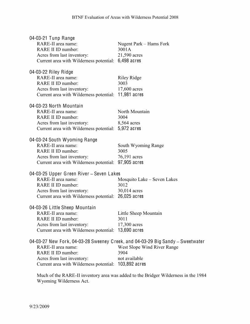
04-03-21 Tunp Range RARE-II area name: Nugent Park B Hams Fork
RARE II ID number: 3001A
Acres from last inventory: 21,590 acres
Current area with Wilderness potential: 6,498 acres
04-03-22 Riley Ridge RARE-II area name: Riley Ridge
RARE II ID number: 3003
Acres from last inventory: 17,600 acres
Current area with Wilderness potential: 11,981 acres
04-03-23 North Mountain RARE-II area name: North Mountain
RARE II ID number: 3004
Acres from last inventory: 8,564 acres
Current area with Wilderness potential: 5,972 acres
04-03-24 South Wyoming Range RARE-II area name: South Wyoming Range
RARE II ID number: 3005
Acres from last inventory: 76,191 acres
Current area with Wilderness potential: 97,905 acres
04-03-25 Upper G reen River ! Seven Lakes
RARE-II area name: Mosquito Lake B Seven Lakes
RARE II ID number: 3012
Acres from last inventory: 30,014 acres
Current area with Wilderness potential: 26,025 acres
04-03-26 L ittle Sheep Mountain
RARE-II area name: Little Sheep Mountain
RARE II ID number: 3011
Acres from last inventory: 17,300 acres
Current area with Wilderness potential: 13,690 acres
04-03-27 New Fork , 04-03-28 Sweeney C reek , and 04-03-29 Big Sandy ! Sweetwater
RARE-II area name: West Slope Wind River Range
RARE II ID number: 3904
Acres from last inventory: not available
Current area with Wilderness potential: 103,892 acres Much of the RARE-II inventory area was added to the Bridger Wilderness in the 1984
Wyoming Wilderness Act.

BTNF Evaluation of Areas with Wilderness Potential 2008
9/23/2009
E V A L U A T I O N O F E L I G IBI L T Y F A C T O RS B Y A R E A
BTNF Evaluation of Areas with Wilderness Potential 2008
9/23/2009
04-03-01 PA C I F I C - B L A C K R O C K C R E E K (23,760 A C R ES)
C APA BI L I T Y . Natural and undeveloped characterKhigh. Nearly all of this area lies within the SPNM
recreation setting. Non-native plant species are few and species at risk, including the gray wolf,
Canada lynx, and grizzly bear, find quality habitat here. U.S. 26 and the Buffalo Valley Road lie
south of the area and the sights and sounds of human activity are evident in some places; the
north boundary of the area is the Teton Wilderness.
Other than trails there is little evidence of human activity although adjacent developments such
as the dude ranches, private homes and associated roads are visible from some locations. Pacific
Creek is within a livestock grazing allotment but the cattle numbers are low and their use has not
created an obvious change in vegetation or watershed integrity. One intrusion into the
naturalness of this area is found on the far eastern marginKthe electronic reflector that stands on
the butte east of Breccia Peak.
Outstanding opportunities for solitude and primitive, unconfined recreationKthis varies widely
by season. For most of the summer, aside from mainline trails, the opportunity for solitude and
unconfined recreation is high. There is a good deal
of activity summer-long in the vicinity of Pacific
Creek and Turpin Meadows, especially along the
main trail corridors and the trails used by outfitters
and dude ranches. Away from these areas, the
opportunity for solitude is high. Davis Hill, Lava
Creek, the frontal hills of Mt. Randolph, the
Holmes Cave and Breccia Pass trails all receive
relatively low use in summer. Fall hunting season
brings more people to some of these areas, but the
highest use season is winter. Snowmobile use
occurs nearly everywhere except where terrain and
winter range closures do not allow it, and the
sights, sounds, and tracks of many snow machines
reduce the winter opportunities for solitude in
much of this area.
Although most of this area is close to roads and
settlements, the rugged terrain, opportunities for
cross-country travel, climbing and cave
exploration, and presence of grizzly bears add to the challenge and skills needed to travel in this
area. The sights and sounds of recreation complexes, a main highway, and private residences are
fairly evident and close to many parts of the area, yet forested draws have a remote feel. Since
this area is contiguous with the vast Teton Wilderness, there is a sense of remoteness possible
even in this relative front country.
!"#$%&$"''(#%)#**%
Near Breccia Pass

BTNF Evaluation of Areas with Wilderness Potential 2008
9/23/2009
Special features and valuesKhigh. Some of the largest spruce trees in the BTNF are found along
Pacific Creek. The Breccia Cliffs are regionally known for scenery and caves. The area is within
the grizzly bear primary recovery area and provides habitat for a number of other wildlife
species. Breccia Pass and Angles Mountain offer reasonably easy access to the Teton
Wilderness, with incredible views; these are popular areas for winter sports.
ManageabilityKmoderate. This area offers a transition zone between a highway corridor and the
Teton Wilderness. Parts could be managed as wilderness with definable boundaries (the area
north of Davis Hill, between Pacific Creek and the existing Teton Wilderness boundary). Much
of the area would be difficult to manage as wilderness because of the current recreation use
levels and types of use, large numbers of people per day
and large party sizes using some of the area, the proximity
of developments, and the long, narrow configuration.
!!
A V A I L A BI L I T Y . This area is available for wilderness designation. Resource
uses that would be facilitated by such designation include
non-motorized backcountry recreation, retention of
wildlife habitat, livestock grazing, natural scenery,
watershed values and water quality, and natural processes
that could change vegetation patterns, such as fire. Other
resource uses that would not be compatible should the area
be added to the Wilderness system include motorized
recreation, fuels treatments and prescribed fire, timber
harvest, and the construction of permanent facilities.
The land is entirely within the Bridger-Teton National
Forest. The Forest Service has a high degree of control
over the surface of the area to prevent incompatible uses that would lessen wilderness character
and potential.
Potential effects of wilderness designation on adjacent lands include limiting mechanical fuels
treatments to reduce the risk of fire near developments. Guided services relying on motorized
equipment and traveling with large parties would also be restricted.
N E E D . Wilderness for this area would contribute little to the local and national distribution of wilderness
but would add scenic features and additional wildlife habitat to the existing Teton Wilderness.
Wilderness designation would meet desires expressed by those seeking quiet sports in winter.
The area provides opportunities for unconfined outdoor recreation experiences already;
wilderness designation would assure that this would be the case all year. Wilderness designation
would help assure the ability of certain biotic species, including grizzly bear, to compete with
increasing public use and development that affects their habitats.
"#$%%&'!('))!*#'&+ +,-."*%/01,2#(,%3$04%25"%"#*2%

BTNF Evaluation of Areas with Wilderness Potential 2008
9/23/2009
04-03-02 SPR E A D C R E E K ! G R OS V E N T R E RI V E R (205,117 A C R ES)
C APA BI L I T Y . Natural and undeveloped characterKmoderate to high, depending on which part of this large and
diverse area is considered. The breakdown of acreage in each ROS physical setting shows that
30% of the area is Primitive, 50% SPNM and 15% SPM, the remainder being within areas of
influence of open forest system roads. Non-native species that alter the composition of natural
plant and animal communities are few or absent, as are any developments that degrade the free-
flowing condition of rivers and streams. Water quality is high and watershed conditions are
healthy and functioning properly. Ecological communities or species that are rare or at risk find
protection and quality habitat in the area, including grizzly bear, gray wolf, sage grouse, and
Canada lynx.
Outstanding opportunities for solitude and primitive, unconfined recreationKhigh in most of the
area. The opportunity for solitude is quite high in summer. During the deer and elk hunting
seasons considerable use takes place and motorized use of the backcountry is at its peak. Solitude
in winter is found away from the main trail system; the state of Wyoming grooms numerous
snowmobile trails, some of which are within the area.
Away from the main trails, there are places where there is little chance of meeting another party.
Terrain is rugged and assistance in an emergency is far away. The area demands physical ability,
orienteering, and outdoor skills to
safely recreate.
Because of the size and diversity of
the Spread Creek-Gros Ventre River
area the sense of remoteness is quite
variable from place to place. In
many places a feeling of remoteness
can be gained soon after leaving the
trailhead. Slate Creek is an example;
one must ford the Gros Ventre
River, which even in low water can
be a considerable task. Topographic
enclosure quickly places distance
between the sights and sounds of the
Gros Ventre Road and the
backcountry visitor. Distant views
of the high country within the Gros Ventre Wilderness further enhance this feeling. In other parts
of the area, the country is open and screening is slight, but there is little in the way of human
developments to screen. Some of the roads that give access to the area are many miles long and
fairly primitive, with native surface and one lane. By the time the visitor reaches one of the more
distant trailheads, he/she has driven the better part of an hour after leaving the pavement. The
primary access for this area is via the Gros Ventre Road on the south, Ditch Creek, Shadow
Moccasin Basin
BTNF Evaluation of Areas with Wilderness Potential 2008
9/23/2009
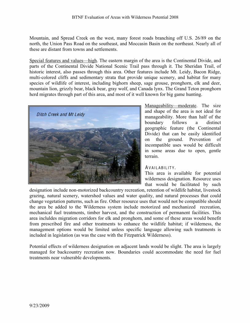
Mountain, and Spread Creek on the west, many forest roads branching off U.S. 26/89 on the
north, the Union Pass Road on the southeast, and Moccasin Basin on the northeast. Nearly all of
these are distant from towns and settlements.
Special features and valuesKhigh. The eastern margin of the area is the Continental Divide, and
parts of the Continental Divide National Scenic Trail pass through it. The Sheridan Trail, of
historic interest, also passes through this area. Other features include Mt. Leidy, Bacon Ridge,
multi-colored cliffs and sedimentary strata that provide unique scenery, and habitat for many
species of wildlife of interest, including bighorn sheep, sage grouse, pronghorn, elk and deer,
mountain lion, grizzly bear, black bear, gray wolf, and Canada lynx. The Grand Teton pronghorn
herd migrates through part of this area, and most of it well known for big game hunting.
ManageabilityKmoderate. The size
and shape of the area is not ideal for
manageability. More than half of the
boundary follows a distinct
geographic feature (the Continental
Divide) that can be easily identified
on the ground. Prevention of
incompatible uses would be difficult
in some areas due to open, gentle
terrain.
A V A I L A BI L I T Y . This area is available for potential
wilderness designation. Resource uses
that would be facilitated by such
designation include non-motorized backcountry recreation, retention of wildlife habitat, livestock
grazing, natural scenery, watershed values and water quality, and natural processes that could
change vegetation patterns, such as fire. Other resource uses that would not be compatible should
the area be added to the Wilderness system include motorized and mechanized recreation,
mechanical fuel treatments, timber harvest, and the construction of permanent facilities. This
area incluldes migration corridors for elk and pronghorn, and some of these areas would benefit
from prescribed fire and other treatments to enhance the wildlife habitat; if wilderness, the
management options would be limited unless specific language allowing such treatments is
included in legislation (as was the case with the Fitzpatrick Wilderness).
Potential effects of wilderness designation on adjacent lands would be slight. The area is largely
managed for backcountry recreation now. Boundaries could accommodate the need for fuel
treatments near vulnerable developments.
,+'*$!-#$$. Ditch Creek and Mt Leidy

BTNF Evaluation of Areas with Wilderness Potential 2008
9/23/2009
N E E D . If added to the National Wilderness Preservation System, this area would likely continue to
attract visitors from the local area and region, similar to the Gros Ventre Wilderness to the south.
The area is remote to large population centers and tourist destinations; access to it is by unpaved
roadway with few developments. Visitors without some sense of adventure would be unlikely to
seek it out. Existing winter trails within the groomed system would be reduced or relocated and
the opportunity for snowmobile use would be limited to areas adjacent to the Spread Creek-Gros
Ventre River. Wilderness here would contribute to the distribution of wilderness by providing a link between
the Teton Wilderness and other wild areas to the south. It offers different terrain and recreation
opportunities than nearby wilderness so it would not likely reduce visitor pressure on other
wildernesses. Parts of this area have become established as OHV areas, particularly Slate Creek
and its tributaries, so wilderness designation would eliminate that use; there are few
opportunities within the Jackson Hole area to replace these trails if closed to OHVs.
The area provides opportunities for unconfined outdoor recreation experiences already and will
likely continue to do so without wilderness designation. Wilderness designation would help
assure the ability of certain biotic species to compete with increasing public use and development
that affects their habitats, and would provide a sanctuary for those biotic species that have
demonstrated an inability to survive in less than primitive surroundings (grizzly bear and Canada
lynx among them).
04-03-03 G RI Z Z L Y L A K E (3,995 A C R ES) C APA BI L I T Y . Natural and undeveloped characterKmoderate. The
BTNF lands within the area are all SPNM; a number of
private parcels exist at the north margin of the area; most
of these are ranches with associated buildings and
activities.
Outstanding opportunities for solitude and primitive,
unconfined recreationKhigh. The trail to Grizzly Lake is
moderately used and it is possible to find no one else on
the trail except on high-season weekends; this trail also
gives access to Blue Miner Lake in the Gros Ventre
Wilderness. The area lies between the Gros Ventre
Wilderness and the river; although one is never far from
human activity along the Gros Ventre road or the ranches
in the area, the topography and forest cover in places lend
a sense of remoteness.
Grizzly Lake
BTNF Evaluation of Areas with Wilderness Potential 2008
9/23/2009
Special features and valuesKhigh. The Gros Ventre Slide geologic site lies partly within this
area; the south shore of Slide Lake is in the area, as well as part of the Gros Ventre River, a
Scenic River candidate. Grizzly Lake is a small, shallow lake; it and another small lake to the
east (during wet years) are used by nesting trumpeter swans and other waterfowl. Scenic views
include the Red Hills and Teton Range.
ManageabilityKhigh. This area could be managed as wilderness; it can be protected from
unauthorized uses and is sheltered from nearby developments. Its southern boundary meets the
Gros Ventre Wilderness. A V A I L A BI L I T Y . The area is available for potential wilderness designation. The area is already being managed for
non-motorized recreation and wildlife habitat. Resource uses that would continue as is or be
facilitated by designation include backcountry recreation, retention of wildlife habitat, current
levels of livestock grazing, natural scenery, watershed values and water quality, and natural
processes that could change vegetation patterns, such as fire. Land and resource uses that would
not be compatible should the area be added to the wilderness system include motorized
recreation, fuels treatments, timber harvest and salvage, commercial uses other than livestock
permittees, outfitter-guides, and other uses typically found in wilderness, the construction of
permanent facilities, and intensive resouce alterations that may be necessary for fish and wildlife
habitat.
N E E D . Public land values of interest are being protected in this area under current management, and
addition of the area would be unlikely to take pressure off popular recreation destinations
elsewhere in the Gros Ventre Wilderness. Addition of this area would add lower elevation
forests, sagebrush habitats and nesting areas for swans and other waterfowl to the wilderness
system (as well as to the Gros Ventre Wilderness). Fuels projects to help protect private parcels
would be restricted should this area be added to the wilderness.
04-03-04 PH I L L IPS RID G E (9,785 A C R ES)
C APA BI L I T Y . Natural and undeveloped characterKmoderate. The area is adjacent to the Jedediah Smith
Wilderness and Grand Teton National Park, and most of it is in a natural condition. A sheep
allotment (now closed) once included part of the area but the sheep were only driven through and
not left for long periods so the native vegetation is not altered here. Areas of lower natural
integrity are those that have a few site-specific alterations to the natural landscape: the avalanche
control devices on Mt. Glory, old roads and structures in Cody Bowl, and some primitive roads
near the power line (most of the line and its associated road access points are not within the
area). The Ski Lake/Phillips Pass area receives heavy recreation use year-round and trails have
been upgraded to handle this use, with bridges and other structures.

BTNF Evaluation of Areas with Wilderness Potential 2008
9/23/2009
Most of the area contains outstanding natural beauty, with extensive wildflower parks, views in
all directions, and little sign of human activity. The power line has become more visible since it
was upgraded in the mid-1990s, and the developed valleys on both sides of the Teton Range are
visibleKespecially at nightKbut within the area itself a natural setting prevails.
Outstanding opportunities for solitude and primitive, unconfined recreationKmoderate. As
suggested above, solitude is not something most people expect when traveling the main trails.
One can expect to encounter numerous other parties on trails during most of the summer. User
conflicts, especially between skiers and snowmobilers, occur in some areas, and are expanding as
machines become increasingly capable of using steep terrain. Noise from WYO 22 and
snowmobiles can be heard for considerable distances within this area. Some trails have become
popular for mountain biking; others are used mostly by hikers and horseback riders. Those who
travel off the beaten track will still find few others. Most use is day use; primitive overnight
facilities built for winter are fallen into disrepair or are now gone.
The area is large enough to include bowls and valleys without trails and small pockets that
receive little use most of the year, but for the major part of this area there is not a high degree of
remoteness. Access is from the Teton Pass highway and Jackson Hole Mountain Resort. An
extensive trail system gives access to most popular sites and destinations; views give orientation
and from many places it is easy to see the settlements of Jackson Hole, the LWE power line, and
hear the traffic on Teton Pass.
Special features and valuesKmoderate. Ski Lake is one of the most popular and easily reached
subalpine lakes in the area. Rendezvous Mountain is the main landmark on the south end of the
Teton Range; Mt. Glory is well known to winter and
summer visitors; Cody Bowl, accessed via the ski area
offers out-of-bounds skiing and a place to see
wildflowers in the alpine vegetation zone.
ManageabilityKmoderate. Because of its proximity to
an existing wilderness and Grand Teton National Park,
parts of the area could be managed as wilderness.
However, it currently serves as a suitable recreation area
that can handle large numbers and many kinds of use,
including uses and party sizes that would be
incompatible with wilderness, and thus it offers an
alternative to wilderness than many people value.
A V A I L A BI L I T Y . Most of this area is available for potential wilderness
designation. Resource uses that would continue as is or
be facilitated by designation include backcountry
recreation, retention of wildlife habitat, natural scenery,
watershed values and water quality, and natural
Ski lake area

BTNF Evaluation of Areas with Wilderness Potential 2008
9/23/2009
processes that could change vegetation patterns, such as fire. Land and resource uses that would
not be compatible should the area be added to the wilderness system include motorized
recreation, fuels treatments, timber harvest and salvage, commercial uses other than livestock
permittees, outfitter-guides, and other uses typically found in wilderness, the construction of
permanent facilities, and intensive resouce alterations that may be necessary for fish and wildlife
habitat. Current commitments to other resource use, such as powerlines, avalanche control, and
downhill ski area operations, could be accomodated through boundary adjustments.
N E E D . The need for wilderness designation in this area is probably not as great as the need for a scenic
backcountry recreation area that can handle large numbers of people near communities.
Wilderness designation would not be likely to reduce visitor pressure on other wildernesses or
meet a need for wilderness related uses. The area provides some opportunity for unconfined
outdoor recreation experiences already; wilderness designation would assure that some of this
use would continue while other activities would be displaced.
04-03-05 PA L ISA D ES (80,307 A C R ES, IN C L UDIN G T H E PA L ISA D ES WSA)
C APA BI L I T Y . Natural and undeveloped characterKhigh. The breakdown of acreage in each ROS physical
setting shows that 25% of the BTNF section of the area is Primitive, 60% SPNM, and 15% SPM
or within the area of influence of nearby roads.
The area near Teton Pass and Black Canyon is an
exception, due to the many structures, rights-of-
way, and high recreation use.
Long-term ecological processes are intact and
operating in this area, nearly all of which is part of
the Palisades Wilderness Study Area. For most of
the WSA alterations such as physical
developments (e.g. roads, utility rights-of-way) are
limited to the northern boundary. Some alteration
of native vegetation has occurred in places, mostly
along trails and old sheep bed grounds.
Constructed facilities for recreation, domestic
livestock grazing, and other activities are minor
and primitive in nature, and have no significant
influence on long-term ecological processes. A
high degree of natural integrity exists in the area.
Outstanding opportunities for solitude and
primitive, unconfined recreationKhigh. The WSA offers visitors outstanding opportunities to
Red Creek

BTNF Evaluation of Areas with Wilderness Potential 2008
9/23/2009
experience adventure, challenge, and to practice skills of self-reliance. The area is large enough
to accommodate multi-day trips; it offers a feeling of large size and remoteness. Although the
area is close to Jackson Hole and some trailheads originate along paved highways, it is distant
from large population centers and for much of the year receives low to moderate levels of
recreation use. The area has a high capability of providing primitive and unconfined types of
recreation, including camping, hunting, fishing, ski touring and winter camping, backpacking,
hiking, riding, photography, and other outdoor activities. Several outfitter-guides operate in the
area; their use, as well as most private recreation use is concentrated on certain trails during the
fall hunting season. In many parts of this area the opportunity for solitude is high, though one is
likely to encounter bands of domestic sheep.
A good trail system penetrates this area but there are many places where cross-country travel is
possible, with the need to route-find, ford creeks, and travel over rough and steep terrain. Some
trails are gentle and moderately used; others are steep and rarely used except during the fall
hunting season. Most of the peaks can be hiked up, though they are remote and steep enough that
these are long and challenging hikes.
Special features and valuesKhigh. The Palisades WSA includes high peaks (Indian, Wolf, and
Observation Peaks are the highest within the BTNF part of the WSA), with beautiful subalpine
terrain. A variety of plant communities and vegetation types exists in the area, including some
that are restricted to only a few places
within the BTNF (curl-leaf mahogany;
bigtooth maple). Among the peaks
that contain alpine plants, substantial
populations of uncommon species
exist. Aquilegia jonesii and
Lesquerella multiceps have been
documented on Ferry Peak.
From many high points in the WSA
there are views of distant mountain
ranges. Montane parklands in the mid-
to-upper elevations have a wide
diversity of forbs that create
spectacular wildflower displays all summer. Wolf Creek, Red Pass, and the head of Cabin Creek
contain scenic cliffs and colorful rock strata. Many places in the lower elevations of the WSA
have bigtooth maple, aspen, a variety of deciduous shrubs, all colorful attractions in the fall.
Wolf Creek is an eligible Wild River.
Wildlife includes several species of special interest: osprey and bald eagle near the Snake River,
wolverine, elk, moose, mule deer, bighorn sheep, and introduced Rocky Mountain goat.
Opportunities for seeing wildlife and hunting are outstanding.
"#$#%&#'()(*+!,(%,-!"#$%&'($)*%+$(,-.$/)%01-2-*3%*'%40506$%*#-)%0($0%*'%($*0-5%057%$5#05.$%*#$%
#**.('/*&0!1(02/00&1!#'34&! (0!,(%,! 53.!630*!35! *,&!7#)(0#1&0!89:-!;,&!#.&#! (0! )#.%&!#$1! ($*#2*!
Botany field trip, Dog Creek

BTNF Evaluation of Areas with Wilderness Potential 2008
9/23/2009
&$3/%,! #*! (*0! 23.&! *3! '&! �()+! 6#$#%&1! *3! .&*#($! #$1! &$,#$2&! (*0! '#2<23/$*.+! 0&**($%! #$1!
2,#.#2*&.!=,&*,&.!6#$#%&1!#0!(*! (0!3.!#0!>3*&$*(#)!5/*/.&!=()1&.$&00-!;,&!#.&#!'3/$1#.+!236&0!
?/(*&!2)30&!*3!&@(0*($%!.3#10!#$1!,(%,=#+0!'/*!*,&.&!(0!4&%&*#*(3$!#$1!*3>3%.#>,(2!02.&&$($%!($!
6#$+!#.�-
A V A I L A BI L I T Y . The area is available for potential wilderness designation. Resource uses that would continue as
is or be facilitated by designation include backcountry recreation, retention of wildlife habitat,
current levels of livestock grazing, natural scenery, watershed values and water quality, and
natural processes that could change vegetation patterns, such as fire. Land and resource uses that
would not be compatible should the area be added to the wilderness system include motorized
recreation, fuels treatments, timber harvest and salvage, commercial uses other than livestock
permittees, outfitter-guides, and other uses typically found in wilderness, the construction of
permanent facilities, and intensive resouce alterations that may be necessary for fish and wildlife
habitat.
The land is entirely within the Bridger-Teton National Forest. The Forest Service has a high
degree of control over the surface of the area to prevent incompatible uses that would lessen
wilderness character and potential. Highway and power line rights of way and an electronic site
exist on the margins of the area; wildland-urban interface areas that benefit from mechanical
treatments occur on the eastern margin of the area, this boundary has identifiable fuels reduction
needs to reduce the risk of wildfire to adjacent land and therefore is not available as wilderness.
However, small boundary adjustments could accommodate these uses and needs with little
reduction in the area of potential wilderness.
Some parts of the Palisades WSA area have concentrated recreation use (Teton Pass) and a great
deal of attraction for recreation activities that would be incompatible with wilderness. There are
also some lands committed through contracts, permits, and agreements that would be in conflict
with wilderness management. Boundary adjustments could accommodate some, but not all,
potentially conflicting uses.
N E E D . If added to the National Wilderness Preservation System, this area would likely continue to
attract visitors from the local area and region. Trails are primitive and some are not maintained;
visitors without some sense of adventure would be unlikely to seek this area. The Palisades area offers different terrain and recreation opportunities than nearby wilderness;
designation would not likely reduce visitor pressure on other wildernesses. Parts of this area have
established mountain bike trails, snowmobile areas, and the only heli-skiing operation on the
forest, so wilderness designation would eliminate these uses.

BTNF Evaluation of Areas with Wilderness Potential 2008
9/23/2009
The area provides opportunities for
unconfined outdoor recreation
experiences already and will likely
continue to do so without wilderness
designation. Wilderness designation
would help assure the ability of
certain biotic species to compete
with increasing public use and
development that affects their
habitats, and would provide a
sanctuary for those biotic species
that have demonstrated an inability
to survive in less than primitive
surroundings (wolverine).
04-03-06 C UR T IS C A N Y O N (9,580 A C R ES)
C APA BI L I T Y . Natural and undeveloped characterKmoderate. The breakdown of acreage in each ROS physical
setting shows that about half the area is SPNM, 20% SPM, and 30% roaded natural. Some non-
native grass species are found in the area, the result
of revegetation projects after disturbances in the past.
Water quality is high and the only impoundment that
affects a free-flowing stream is at Flat Creek Lake,
on private land. Lights and sounds of settlement
nearby are evident from most parts of this area.
Outstanding opportunities for solitude and primitive,
unconfined recreationKlow. The opportunity to be
alone, but sights and sounds of human activity are
evident in most places. Terrain is not highly
challenging or remote, though some features attract
recreationists seeking challenge; these are mostly
front-country rock faces favored by sport climbers.
Special features and valuesKmoderate. This area is
known for spectacular views of the Tetons, enjoyed
from the main road system that gives access to
campsites and trailheads. Other special values include wildlife, particularly elk, which move
across the area from the adjacent National Elk Refuge, bison, bears, falcons, and gray wolves.
Wolf Mountain, Salt River Range in the distance
Foothills north of Sheep Creek

BTNF Evaluation of Areas with Wilderness Potential 2008
9/23/2009
ManageabilityKlow. This area is contiguous with the National Elk Refuge on one side and the
Gros Ventre Wilderness on the other, but even so, it would be difficult to manage as wilderness,
given the configuration of popular open roads that create an irregular area. A V A I L A BI L I T Y . The area is unavailable for potential wilderness designation because of other resource values that
the BTNF has committed to (vegetation management, including prescribed fires, for wildlife
habitat enhancement purposes and to protect nearby private lands).
N E E D . The need for this area to be added to the Gros Ventre Wilderness is not apparent; its inclusion
would not be expected to reduce recreation pressure on the wilderness. The SPNM parts of the
area are already being managed for their natural attributes, and there may be some benefit to
vegetation treatments to enhance elk winter range that would not be appropriate in wilderness.
04-03-07 C A C H E C R E E K (14.866 A C R ES) C APA BI L I T Y . Natural and undeveloped characterKmoderate. The ROS physical setting is primarily SPNM; it
is contiguous with the west side of the Gros Ventre Wilderness. Most of the area is in a natural
condition. An old road exists in upper Cache Creek (Noker coal mine access), but it bears more
resemblance to a trail than a road; the coal quarry is small and inconspicuous. The main road in
Cache Creek from the trailhead to Gin Pole Draw is not part of area with wilderness potential.
Outstanding opportunities for solitude and
primitive, unconfined recreationKlow. The
area is readily accessed from a number of
locations and receives considerable recreation
in all seasons; along the main trail system
opportunity for solitude is rare. Views from
open areas and high points often include
developments on Snowking, the town of
Jackson, and the nearby valley.!
Special features and valuesKlow. The
opportunity to see wildlife is notable and the
area includes lovely wildflower parks, but these
features are typical for the surrounding area.
ManageabilityKlow. Parts of this area are
already being managed as non-motorized
backcountry, though the use level and
6#'7*0,%)"#7%3$04%30025(..*%
Cache Creek from Gros Ventre Wilderness

BTNF Evaluation of Areas with Wilderness Potential 2008
9/23/2009
concentration may not be compatible with wilderness purposes. Other parts of the area would be
difficult to manage as wilderness due to their location relative to the town of Jackson and the
greater Snowking area.
A V A I L A BI L I T Y . Much of the area is committed to concentrated recreation use since Cache Creek has a great deal
of attraction for recreation activities that would be incompatible with wilderness. The upper
elevations are available for potential wilderness designation. Resource uses that would continue
as is or be facilitated by designation include backcountry recreation, retention of wildlife habitat
and current levels of livestock grazing, retention of natural scenery, watershed values and water
quality, and allowance of natural processes that could change vegetation patterns, such as fire.
Land and resource uses that would not be compatible should the area be added to the wilderness
system include motorized recreation, fuels treatments, timber harvest and salvage, commercial
uses other than livestock permittees, outfitter-guides, and other uses typically found in
wilderness, the construction of permanent facilities, and intensive resouce alterations that may be
necessary for fish and wildlife habitat.
N E E D . The area is adjacent to the Gros Ventre Wilderness. Addition of this area would include some
habitats and plant communities that are considered underrepresented in protected areas, including
sagebrush, grasslands, and mountain shrubs. Most of the area is already committed to outdoor
recreation purposes for which there is a growing need and which is not in keeping with
wilderness management.
04-03-08 C A MP C R E E K (5,966 A C R ES) C APA BI L I T Y . Natural and undeveloped characterKmoderate. The ROS physical setting is primarily SPNM; it
is contiguous with the Gros Ventre Wilderness. Most of the area is in a natural condition, though
there are areas of non-native grass and evidence of heavy grazing and browsing by wildlife in the
Camp Creek area where two elk feed grounds contribute to an unnaturally high concentration of
elk for part of the year. An old road and stock tank exist in Little Horse Creek though the only
sign of the road is the smooth brome along its trace. A private communication tower exists on the
southern margin of the area and a power line ROW exists in a small part of the west side.
Outstanding opportunities for solitude and primitive, unconfined recreationKmoderate. The area
is readily accessed from the Camp Creek elk feed ground and receives considerable recreation
use in summer and fall. Views from open areas and high points include developments in the
nearby valleys and the sights and sounds of U.S. 191. Once north and east of Camp Creek
Saddle, the sights and sounds of nearby developments area mostly gone. Little Horse Creek is a
popular route into the upper elevations during hunting season; for much of the summer there is
little recreation use here.
BTNF Evaluation of Areas with Wilderness Potential 2008
9/23/2009
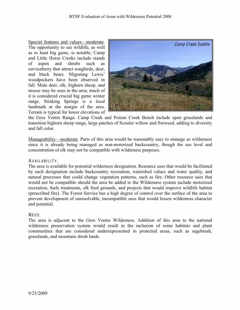
Special features and valuesKmoderate.
The opportunity to see wildlife, as well
as to hunt big game, is notable; Camp
and Little Horse Creeks include stands
of aspen and shrubs such as
serviceberry that attract songbirds, deer,
%6*# 51%0@# 5'%&"L# M/+&%,/6+# N'./"!#
woodpeckers have been observed in
fall. Mule deer, elk, bighorn sheep, and
moose may be seen in the area; much of
it is considered crucial big game winter
range. Stinking Springs is a local
landmark at the margin of the area.
Terrain is typical for lower elevations of
the Gros Ventre Range. Camp Creek and Poison Creek Bench include open grasslands and
transition bighorn sheep range, large patches of Scouler willow and fireweed, adding to diversity
and fall color.
ManageabilityKmoderate. Parts of this area would be reasonably easy to manage as wilderness
since it is already being managed as non-motorized backcountry, though the use level and
concentration of elk may not be compatible with wilderness purposes.
A V A I L A BI L I T Y . The area is available for potential wilderness designation. Resource uses that would be facilitated
by such designation include backcountry recreation, watershed values and water quality, and
natural processes that could change vegetation patterns, such as fire. Other resource uses that
would not be compatible should the area be added to the Wilderness system include motorized
recreation, fuels treatments, elk feed grounds, and projects that would improve wildlife habitat
(prescribed fire). The Forest Service has a high degree of control over the surface of the area to
prevent development of unresolvable, incompatible uses that would lessen wilderness character
and potential.
N E E D . The area is adjacent to the Gros Ventre Wilderness. Addition of this area to the national
wilderness preservation system would result in the inclusion of some habitats and plant
communities that are considered underrepresented in protected areas, such as sagebrush,
grasslands, and mountain shrub lands.
Camp Creek Saddle

BTNF Evaluation of Areas with Wilderness Potential 2008
9/23/2009
04-03-09 SH O A L C R E E K (105,467 A C R ES).
Originally part of the Gros Ventre RARE-II area; Shoal Creek Wilderness Study Area is inlcuded in this
area with wilderness potential.
C APA BI L I T Y . Natural and undeveloped characterKhigh. The breakdown of acreage in each ROS physical
setting shows that nearly all of the area is SPNM, though that mapping does not reflect the
presence of the contiguous Gros Ventre Wilderness, the inclusion of which would add some
Primitive setting to the core area. The only structures are trails, established campsites, range
allotment fences and minor structures in support of permitted activities such as outfitted hunting
trips. Salvage logging after forest fires in the
late 1980s and early 1990s has occurred in
Shoal and Dell Creeks and is visible from the
area. Fences and water developments for
cattle are minor and do not detract from the
natural integrity of the area.
Vegetation communities do not contain
evidence of overgrazing or changes in plant
diversity; riparian areas are mostly vigorous
and healthy in appearance. There is some
private land adjacent to the area; these lands
remain largely pastoral in nature, but near
Bondurant many of the larger ranchlands are
being subdivided and lights, noise and
structures on the periphery of the area are
increasing.
Outstanding opportunities for solitude and
primitive, unconfined recreationKmoderate.
The opportunity for solitude is quite high for
most of the summer. During hunting season
much more use takes place, especially along
the primary trails (and parts of the area near popular access roads such as North Fork Fisherman
Creek), and in the heavy-use campsites such as in West Dell and House Creeks. Much of the
hunting is from trailhead and roadside camps, so there is not a lot of crowding in popular
backcountry campsites. Though some destinations, such as Shoal Creek, Tin Can Park, and
Fisherman Creek Lake, can be easily reached as a day outing, much of the area is remote, with
little access through private inholdings.
Forest access roads in Dell Creek and North Fork Fisherman Creek pass nearby and lead to
access points; roads in Riling Draw, Granite Creek, Parody Draw, Rock Creek, and West Dell
Creek give access to trailheads leading into the backcountry. Because of topographic and
8'+',%,/-6#"0&''6/6+#,)'#5%0@0-46,&2#8/"/,-%2#5'+/6#,-#7''1#,)'#%&'%!"#&'3-,'6'""#O4/,'#"--6#
after leaving a trailhead.
Upper Shoal Creek
BTNF Evaluation of Areas with Wilderness Potential 2008
9/23/2009
Special features and valuesKhigh. Scenic views of the southern Gros Ventre Range are
outstanding. A&#*/.&0!35! ($*&.&0*! ($2)/1&!*,&!,(%,!23/$*.+!35! *,&!9,3#)!B.&&<!8()1&.$&00!9*/1+!
:.&#C!($2)/1($%!9,3#)!B.&&<!#$1!;($!B#$!7#.<C!&@*&$0(4&!'&.!>3$10!#$1!.(>#.(#$!#.�C!7#00!
7&#<C!1(4&.0&!4&%&*#*(3$!2366/$(*(&0C!($2)/1($%!63(0*!0,./'!)#$10!*,#*!>.34(1&!0/66&.!,#'(*#*!
53.! $/6&.3/0! $&3*.3>(2#)! 03$%'(.10C! #$1!6(@&1! #0>&$C! 23$(5&.! #$1! >#.<)#$10! *,#*! 355&.! 02&$(2!
4(&=0-!;,&!#.&#!>.34(1&0!(6>3.*#$*!,#'(*#*!53.!'(%!%#6&C!#0!&4(1&$2&1!'+!*,&!$/6'&.!35!,/$*($%!
3/*5(**&.0!/0($%!*,(0!#.&#-!7.3$%,3.$!#$1!6/)&!1&&.!0>&$1!0/66&.0!,&.&!#$1!6(%.#*&!*3!*,&!D.&&$!
E(4&.!'#0($!53.!=($*&.-!9,3#)C!/>>&.!F&))C!#$1!8&0*!F&))!B.&&<0!#.&!2#$1(1#*&!=()1!.(4&.0-!
ManageabilityKhigh. M30*! 35! *,(0! #.&#! =3/)1! '&! .$#')+! �+! *3! 6#$#%&! #0! =()1&.$&00!
'&2#/0&!(*!(0!23$*(%/3/0!=(*,!*,&!D.30!G&$*.&!8()1&.$&00-!;,3/%,!036&!#22&00!(0!.&0*.(2*&1!'+!
>.(4#*&!)#$10!630*!35!*,&!#.&#!2#$!'&!.,&1!4(#!.3#1!3.!*.#()-!
A V A I L A BI L I T Y . Most of this area is available for potential wilderness designation. Resource uses that would be
facilitated by such designation include non-motorized backcountry recreation, retention of
wildlife habitat, livestock grazing, natural scenery, watershed values and water quality, and
natural processes that could change vegetation patterns, such as fire. Other resource uses that
would not be compatible should the area be added to the Wilderness system include motorized
recreation, fuels treatments that are not directly related to wilderness values, timber harvest, and
the construction of permanent facilities. The far eastern part of the area, including Klondike Hill
and areas adjacent to the upper Green River, is part of the Grand Teton pronghorn herd migration
corridor. Vegetation projects such as burning to keep the corridor open may face constraints if
this area were designated wilderness.
Because of private land in the area the Forest Service has a moderate degree of control over
access. Development of more housing on adjacent private land could lessen wilderness character
and potential with more lights and more demand for recreation use in the area. In some parts of
the area subsurface rights are held by oil and gas leasees.
Potential effects of wilderness designation on adjacent lands: the area is largely managed for
backcountry recreation now, so expected changes after designated are slight.
N E E D . The Shoal Creek area offers moderate to high elevations, a mix of shrublands, riparian areas with
beaver ponds, sagebrush flats and forested land. If added to the National Wilderness Preservation
System this area would likely continue to attract local and regional visitors, as it does now. The
area is remote to large population centers and tourist destinations; access to it is by unpaved
roadway with few developments. Visitors without some sense of adventure would be unlikely to
seek it out. Wilderness for this area would contribute to the local distribution of wilderness by adding lower
elevation uplands, frontal hills, and riparian areas to the existing Gros Ventre Wilderness, which
lies mostly above 9,000 feet. Much of this area already provides opportunities for unconfined
outdoor recreation experiences; wilderness designation would assure that the settings for such

BTNF Evaluation of Areas with Wilderness Potential 2008
9/23/2009
recreation continues. Some parts near roads and
highways offer front-country recreation as well (Granite
Creek is an example).
Wilderness designation could help assure the ability of
certain biotic species to compete with increasing public
use and development that affects their habitats,
including amphibians that reply on wetlands and
riparian areas, various big game species, and species of
interest such as goshawks and harlequin ducks. It would
provide a sanctuary for species that have demonstrated
an inability to survive in less than primitive
surroundings.
04-03-10 R ASPB E RR Y RI D G E (9,410 A C R ES) C APA BI L I T Y . Natural and undeveloped characterKmoderate. The area is 85% SPNM and 15% SPM. A trail
that has evolved into a primitive jeep road (not on the forest transportation system) gives access
to the southern part of the ridge, ending at a high bench. An ATV trail has been established from
Highway 191 to the Raspberry Ridge road B neither of these motorized routes are formally
designated [but are proposed for adoption under current travel plan B which would change the
conformation of this area.] The area is natural in character with high water quality, native
vegetation that has not been substantially altered by weeds, and little evidence of human use
other than recreation and cattle grazing and associated structures.
Outstanding opportunities for solitude and primitive, unconfined recreationKmoderate. Sights
and sounds of activity along roads and the highway is evident from non-forested high points, yet
the area receives low use. Other than during hunting season and the winter snowmobile season
the opportunity for solitude is high; during those higher-use times of year this is not the case. The
area is bounded on one side by private ranchlands and grazing areas, the quiet and lack of human
presence on the private land makes the area seem more remote than it is. Activity along the
North Fork Fisherman Creek road and nearby areas is evident from Raspberry Ridge during the
fall and winter.
Special features and valuesKmoderate. Raspberry Ridge is a prominent mid-elevation ridge
north and east of the Hoback Basin. Views of adjacent mountains are outstanding, and the area is
Jack Creek basin
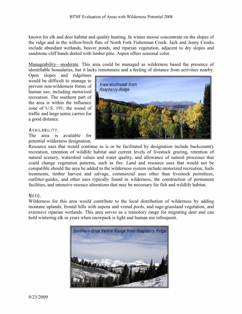
BTNF Evaluation of Areas with Wilderness Potential 2008
9/23/2009
known for elk and deer habitat and quality hunting. In winter moose concentrate on the slopes of
the ridge and in the willow/birch flats of North Fork Fisherman Creek. Jack and Jenny Creeks
include abundant wetlands, beaver ponds, and riparian vegetation, adjacent to dry slopes and
sandstone cliff bands dotted with limber pine. Aspen offers seasonal color.
ManageabilityKmoderate. This area could be managed as wilderness based the presence of
identifiable boundaries, but it lacks remoteness and a feeling of distance from activities nearby.
Open slopes and ridgelines
would be difficult to manage to
prevent non-wilderness forms of
human use, including motorized
recreation. The southern part of
the area is within the influence
zone of U.S. 191; the sound of
traffic and large semis carries for
a good distance.
A V A I L A BI L I T Y . The area is available for
potential wilderness designation.
Resource uses that would continue as is or be facilitated by designation include backcountry
recreation, retention of wildlife habitat and current levels of livestock grazing, retention of
natural scenery, watershed values and water quality, and allowance of natural processes that
could change vegetation patterns, such as fire. Land and resource uses that would not be
compatible should the area be added to the wilderness system include motorized recreation, fuels
treatments, timber harvest and salvage, commercial uses other than livestock permittees,
outfitter-guides, and other uses typically found in wilderness, the construction of permanent
facilities, and intensive resouce alterations that may be necessary for fish and wildlife habitat.
N E E D . Wilderness for this area would contribute to the local distribution of wilderness by adding
montane uplands, frontal hills with aspens and vernal pools, and sage-grassland vegetation, and
extensive riparian wetlands. This area serves as a transitory range for migrating deer and can
hold wintering elk in years when snowpack is light and human use infrequent.
View southwest from Raspberry Ridge
Southern Gros Ventre Range from Raspberry Ridge

BTNF Evaluation of Areas with Wilderness Potential 2008
9/23/2009
04-03-11 T EPE E C R E E K RID G E (4,242 A C R ES)
C APA BI L I T Y . Natural and undeveloped characterKmoderate. The area is entirely SPNM with access via the
Tosi trailhead and 4WD roads to the north and south. The area with wilderness potential is small
and views of nearby roads, old timber harvest areas, and developments in the upper Green River
valley are evident, but it is contiguous with the Gros Ventre Wilderness and thus connected to a
much larger wild area. Much of the ridge itself lies within the Gros Ventre Wilderness.
Outstanding opportunities for solitude and primitive, unconfined recreationKmoderate. Sights
and sounds of activity along the Green River Lakes and Union Pass Roads are evident from non-
forested areas, and this area is bounded on the north and south by open roads that receive light
use by 4WD and ATV traffic. Other than during hunting season and winter (the upper Green
being a popular snowmobile area) the opportunity for solitude is high.
Special features and valuesKmoderate. This area offers scenic views of the upper Green River,
the Wind River Range, and Tosi Basin. Tepee Creek Ridge is the primary feature.
ManageabilityKmoderate. This area is contiguous with the Gros Ventre Wilderness and is a
distinctive geographic feature, so from a boundary definition standpoint it could be managed as
wilderness. The proximity of
roads and other forest
management activities detract
from its manageability. A V A I L A BI L I T Y . The area is available for
potential wilderness designation.
Resource uses that would
continue as is or be facilitated by
designation include backcountry
recreation, retention of wildlife
habitat and current levels of
livestock grazing, retention of
natural scenery, watershed values and water quality, and allowance of natural processes that
could change vegetation patterns, such as fire. Land and resource uses that would not be
compatible should the area be added to the wilderness system include motorized recreation, fuels
treatments, timber harvest and salvage, commercial uses other than livestock permittees,
outfitter-guides, and other uses typically found in wilderness, the construction of permanent
facilities, and intensive resouce alterations that may be necessary for fish and wildlife habitat.
Teepee Creek Ridge area from lower Tosi Creek

BTNF Evaluation of Areas with Wilderness Potential 2008
9/23/2009
N E E D . Wilderness for this area would contribute to the local distribution of wilderness by adding lower
elevation uplands, frontal hills, and sage-grassland vegetation to the existing Gros Ventre
Wilderness, which lies mostly above 9,000 feet in this area.
04-03-12 M O NU M E N T RID G E (17,581 A C R ES)
C APA BI L I T Y . Natural and undeveloped characterKmoderate. The breakdown of acreage in each ROS physical
setting shows that about 90% of the area is SPNM and the rest lies within areas of influence of
roads and U.S. 191. The area includes a cattle grazing allotment, with associated fences and
minor facilities, but there is no obvious reduction in productivity or species diversity as a result
of grazing by either livestock or big game. The area includes year-round habitat for wildlife,
transitional range for migrating elk and deer, and important winter range on the west slope,
which are closed to human entry to provide refuge for big game. The area is also considered
good habitat for Canada lynx. The only human-created features that are easily noticed are some
pasture fences for livestock grazing and the old fire lookout on the summit.
Outstanding opportunities for solitude and primitive, unconfined recreationKmoderate.
Considering the size and proximity of this area to the highway and town of Bondurant, there is a
good opportunity for solitude with many isolated draws and ridge spurs. The area immediately
surrounding the old fire lookout is a scenic attraction with 4WD access from the south, and it
therefore invites more use (although the condition of the road does not). The opportunities for
solitude are high; other than hunting season there are usually few visitors on a given day.
This area is not large and has easy access from the town of Bondurant and nearby subdivisions
and settlements. A system trail provides non-motorized access to the top of the ridge and there
are numerous game trails with views for orientation. The area is relatively close to roads,
including U.S. 191, and
developments on nearby private
land. There is considerable
private land to the north and
east; in the Bondurant area many
of the larger ranchlands are
being subdivided and additional
lights, traffic, and structures
noticeable from Monument
Ridge are increasing. Because
adjacent developments are close
and highly visible from many
parts of the area, they have an
influence on the sense of
Little Cliff Creek and Hoback Range from top of Monument Ridge

BTNF Evaluation of Areas with Wilderness Potential 2008
9/23/2009
remoteness. On the other hand, the character of the Hoback Basin remains rural and
developments are dwarfed by the vista of wild mountains on all sides. The Monument Ridge area
is closed to motor vehicles (in summer) except along the road to the lookout; there is
considerable illegal use of motor vehicles and this is having an effect on the sense of remoteness.
There is a winter range closure at the head of Little Cliff Creek; otherwise the area is open to
snowmobile and ski use, both of which remain light.
Special features and valuesKmoderate. Features of interest include the Monument Ridge
summit, from which a panoramic view of the nearby Gros Ventre Wilderness and Hoback Range
can be had; diverse vegetation communities and extensive aspen stands that are spectacular
during the fall; and habitat for big game and other wildlife. This area has been noted as having
good habitat and a relatively high population of snowshoe hares and is thus of interest from a
lynx conservation standpoint. Pronghorns and mule deer summer in the area and migrate to the
upper Green River Basin for the winter. The historic Hoback Guard Station is available for
public rentals; it lies on the margin of this area.
ManageabilityKmoderate. This area would be somewhat difficult to manage as wilderness
because it is isolated from other backcountry areas by roads and is fairly small. As far as
definable boundaries are concerned, it would be relatively easy to use the surrounding road
corridors as margins. Topographic features are less obvious. Some boundaries, particularly those
near Cliff Creek, act as suitable shields from the sights and sounds of human activity, but most of
the area does not have topographic or vegetation screening from nearby development. Although parts of the north and east side of the area are not accessible because of private land or
the need to ford the Hoback River, most of the area is accessible, and it is small enough that
existing access points provide adequate means for reaching the area. A V A I L A BI L I T Y . This area is available for potential wilderness
designation. Resource uses that would be
facilitated by such designation include
backcountry recreation, retention of wildlife
habitat, livestock grazing, natural scenery,
watershed values and water quality, and natural
processes that could change vegetation patterns,
such as fire. Other resource uses that would not
be compatible should the area be added to the
Wilderness system include motorized recreation,
fuels treatments that are not directly wilderness-
related, and the construction of permanent
facilities.
The land is entirely within the Bridger-Teton
National Forest. The Forest Service has a high
degree of control over the surface of the area to
View north from Monument Ridge
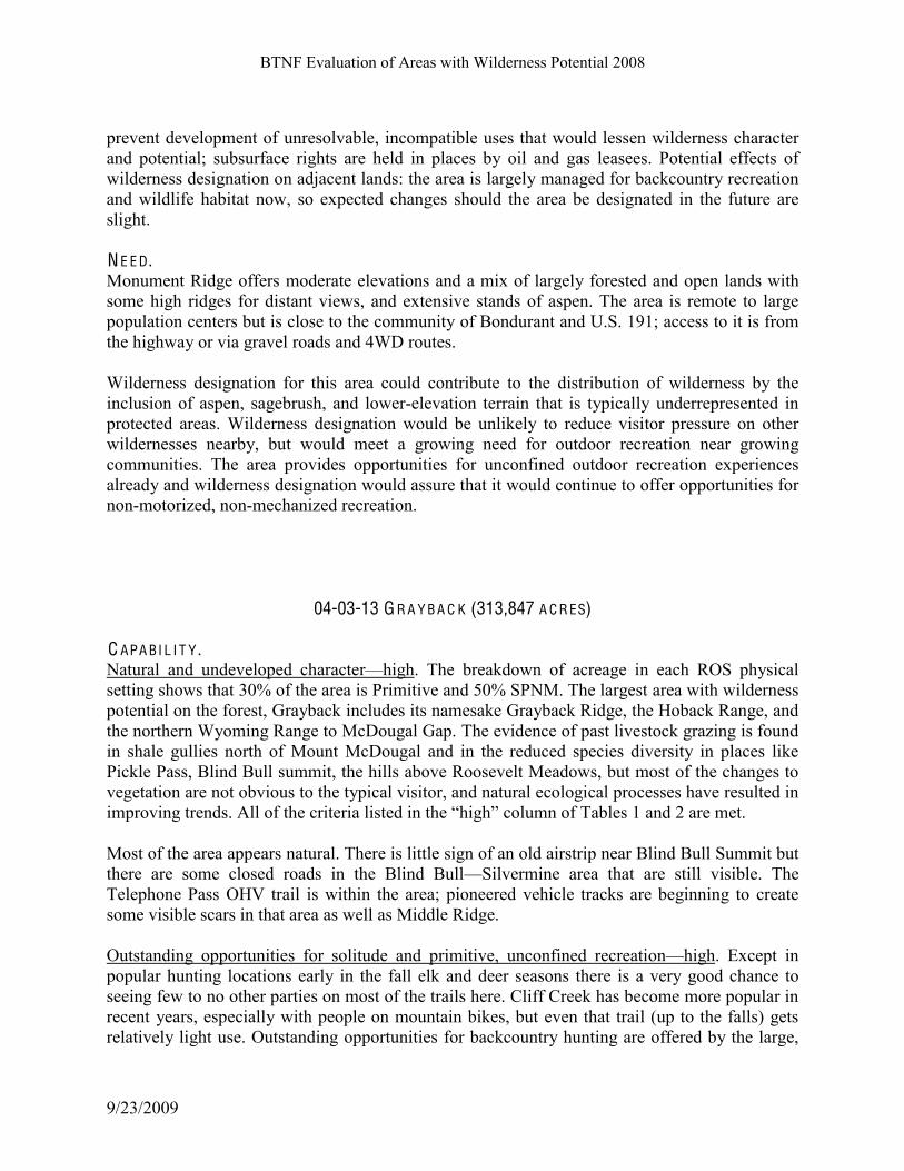
BTNF Evaluation of Areas with Wilderness Potential 2008
9/23/2009
prevent development of unresolvable, incompatible uses that would lessen wilderness character
and potential; subsurface rights are held in places by oil and gas leasees. Potential effects of
wilderness designation on adjacent lands: the area is largely managed for backcountry recreation
and wildlife habitat now, so expected changes should the area be designated in the future are
slight.
N E E D . Monument Ridge offers moderate elevations and a mix of largely forested and open lands with
some high ridges for distant views, and extensive stands of aspen. The area is remote to large
population centers but is close to the community of Bondurant and U.S. 191; access to it is from
the highway or via gravel roads and 4WD routes. Wilderness designation for this area could contribute to the distribution of wilderness by the
inclusion of aspen, sagebrush, and lower-elevation terrain that is typically underrepresented in
protected areas. Wilderness designation would be unlikely to reduce visitor pressure on other
wildernesses nearby, but would meet a growing need for outdoor recreation near growing
communities. The area provides opportunities for unconfined outdoor recreation experiences
already and wilderness designation would assure that it would continue to offer opportunities for
non-motorized, non-mechanized recreation.
04-03-13 G R A Y B A C K (313,847 A C R ES) C APA BI L I T Y . Natural and undeveloped characterKhigh. The breakdown of acreage in each ROS physical
setting shows that 30% of the area is Primitive and 50% SPNM. The largest area with wilderness
potential on the forest, Grayback includes its namesake Grayback Ridge, the Hoback Range, and
the northern Wyoming Range to McDougal Gap. The evidence of past livestock grazing is found
in shale gullies north of Mount McDougal and in the reduced species diversity in places like
Pickle Pass, Blind Bull summit, the hills above Roosevelt Meadows, but most of the changes to
vegetation are not obvious to the typical visitor, and natural ecological processes have resulted in
improving trends. :11#-7#,)'#0&/,'&/%#1/",'*#/6#,)'#P)/+)Q#0-1436#-7#(%51'"#R#%6*#S#%&'#3',L
Most of the area appears natural. There is little sign of an old airstrip near Blind Bull Summit but
there are some closed roads in the Blind BullKSilvermine area that are still visible. The
Telephone Pass OHV trail is within the area; pioneered vehicle tracks are beginning to create
some visible scars in that area as well as Middle Ridge.
Outstanding opportunities for solitude and primitive, unconfined recreationKhigh. Except in
popular hunting locations early in the fall elk and deer seasons there is a very good chance to
seeing few to no other parties on most of the trails here. Cliff Creek has become more popular in
recent years, especially with people on mountain bikes, but even that trail (up to the falls) gets
relatively light use. Outstanding opportunities for backcountry hunting are offered by the large,

BTNF Evaluation of Areas with Wilderness Potential 2008
9/23/2009
remote area and the wildlife it supports. A11#-7#,)'#0&/,'&/%#1/",'*#/6#,)'#P)/+)Q#0-1436#-7#(%51'#I#
are met.
There is a high degree of remoteness in much of this large area. Some of the most remote parts of
the BTNF backcountry are within the Grayback area, particularly in the central core where the
Little Greys and Hoback Rivers and Cliff and Willow Creeks begin. A good trail system
penetrates this area but there are many places where cross-country travel is possible, with the
need to route-find, ford creeks, and travel over rough and steep terrain.
Special features and valuesKhigh. ()/"# /"# ,)'# >-&'",!"# 1%&+'",# 9&/3/,/8'T"'3/-primitive area
outside of wilderness. The upper Hoback and Little Greys Rivers and several of their tributaries
are eligible for inclusion in the National Rivers System. The area includes Deadman Mountain,
Hoback Peak, and Mt. McDougal, high landmarks of
the northern part of the range.
Grayback Ridge is a landmark of scenic and historic
importance, associated with Theodore Roosevelt, who
once hunted in the area. The Wyoming Range National
Recreation Trail passes through the area from Bryan
Flat to McDougal Gap. Nearly all of the area has
distinctive scenic character, with ridges, cliffs, and
multi-colored rock formations, waterfalls, aspen stands,
and extensive subalpine wildflower parks. The area is
well known for big game, especially trophy mule deer,
and parts of it are home to scattered small bands of
bighorn sheep.
ManageabilityKhigh. This area is large and remote
enough to be managed as wilderness. The boundary
comes quite close to existing roads but there is some
vegetation and topographic screening. Most of the area is shielded from the sights and sounds of
human settlement. Forest system roads give access to many trailheads in the area and very little
of it is affected by lack of public access across private land. A V A I L A BI L I T Y . The area is available for potential wilderness designation. Resource uses that would continue as
is or be facilitated by designation include backcountry recreation, retention of wildlife habitat
and current levels of livestock grazing, retention of natural scenery, watershed values and water
quality, and allowance of natural processes that could change vegetation patterns, such as fire.
Land and resource uses that would not be compatible should the area be added to the wilderness
system include motorized recreation, fuels treatments, timber harvest and salvage, commercial
uses other than livestock permittees, outfitter-guides, and other uses typically found in
wilderness, the construction of permanent facilities, and intensive resouce alterations that may be
necessary for fish and wildlife habitat.
Cliff Creek
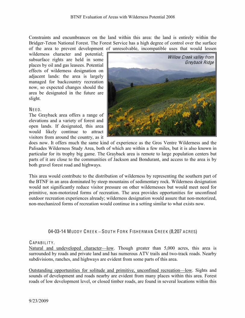
BTNF Evaluation of Areas with Wilderness Potential 2008
9/23/2009
Constraints and encumbrances on the land within this area: the land is entirely within the
Bridger-Teton National Forest. The Forest Service has a high degree of control over the surface
of the area to prevent development of unresolvable, incompatible uses that would lessen
wilderness character and potential;
subsurface rights are held in some
places by oil and gas leasees. Potential
effects of wilderness designation on
adjacent lands: the area is largely
managed for backcountry recreation
now, so expected changes should the
area be designated in the future are
slight.
N E E D . The Grayback area offers a range of
elevations and a variety of forest and
open lands. If designated, this area
would likely continue to attract
visitors from around the country, as it
does now. It offers much the same kind of experience as the Gros Ventre Wilderness and the
Palisades Wilderness Study Area, both of which are within a few miles, but it is also known in
particular for its trophy big game. The Grayback area is remote to large population centers but
parts of it are close to the communities of Jackson and Bondurant, and access to the area is by
both gravel forest road and highways. This area would contribute to the distribution of wilderness by representing the southern part of
the BTNF in an area dominated by steep mountains of sedimentary rock. Wilderness designation
would not significantly reduce visitor pressure on other wildernesses but would meet need for
primitive, non-motorized forms of recreation. The area provides opportunities for unconfined
outdoor recreation experiences already; wilderness designation would assure that non-motorized,
non-mechanized forms of recreation would continue in a setting similar to what exists now.
04-03-14 M UDD Y C R E E K ! SO U T H F O R K F ISH E R M A N C R E E K (8,207 A C R ES) C APA BI L I T Y . Natural and undeveloped characterKlow. Though greater than 5,000 acres, this area is
surrounded by roads and private land and has numerous ATV trails and two-track roads. Nearby
subdivisions, ranches, and highways are evident from some parts of this area.
Outstanding opportunities for solitude and primitive, unconfined recreationKlow. Sights and
sounds of development and roads nearby are evident from many places within this area. Forest
roads of low development level, or closed timber roads, are found in several locations within this
Willow Creek valley from Greyback Ridge

BTNF Evaluation of Areas with Wilderness Potential 2008
9/23/2009
area; the current forest visitor map and the new GIS roads layer do not agree.
Special features and valuesKlow . The area is typical for the lower elevations of the Hoback
Basin, with a mix of forest, aspen, and sagebrush parks. It offers scenic vistas to the Hoback and
Gros Ventre Ranges. It is a popular area for fall hunting and is increasingly used by OHVs.
Muddy Creek is recognized as an important spawning stream for Snake River fine-spotted
cutthroat trout. It is within a larger area of the Hoback Basin that provides habitat for snowshoe
hare (and, potentially, Canada lynx), and serves as big game habitat, both for migration and
winter range.
ManageabilityKlow. This area is
relatively small and isolated from
nearby wild areas and would thus be
difficult to manage as wilderness. Two-
tracks and ATV routes that exist would
be hard to close; roads coming off
nearby private land would make access
hard to manage. Open terrain further
complicates management as wilderness,
making it difficult to prevent
incompatible uses.
A V A I L A BI L I T Y . The area is largely unavailable for
potential wilderness designation; it is
subject to existing energy leases with pre-existing rights and is being managed for recreation
uses that are not compatible with wilderness.
N E E D . There is no apparent need for wilderness designation in this area; the area does not offer
recreation opportunities that are distinctly wilderness-related and its designation would be
unlikely to reduce pressure on other nearby wildernesses.
View toward Hoback Range
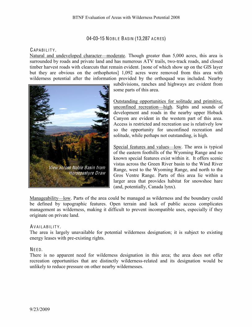
BTNF Evaluation of Areas with Wilderness Potential 2008
9/23/2009
04-03-15 N O B L E B ASIN (13,287 A C R ES) C APA BI L I T Y . Natural and undeveloped characterKmoderate. Though greater than 5,000 acres, this area is
surrounded by roads and private land and has numerous ATV trails, two-track roads, and closed
timber harvest roads with clearcuts that remain evident. [none of which show up on the GIS layer
but they are obvious on the orthophotos] 1,092 acres were removed from this area with
wilderness potential after the information provided by the orthoquad was included. Nearby
subdivisions, ranches and highways are evident from
some parts of this area.
Outstanding opportunities for solitude and primitive,
unconfined recreationKhigh. Sights and sounds of
development and roads in the nearby upper Hoback
Canyon are evident in the western part of this area.
Access is restricted and recreation use is relatively low
so the opportunity for unconfined recreation and
solitude, while perhaps not outstanding, is high.
Special features and valuesKlow. The area is typical
of the eastern foothills of the Wyoming Range and no
known special features exist within it. It offers scenic
vistas across the Green River basin to the Wind River
Range, west to the Wyoming Range, and north to the
Gros Ventre Range. Parts of this area lie within a
larger area that provides habitat for snowshoe hare
(and, potentially, Canada lynx).
ManageabilityKlow. Parts of the area could be managed as wilderness and the boundary could
be defined by topographic features. Open terrain and lack of public access complicates
management as wilderness, making it difficult to prevent incompatible uses, especially if they
originate on private land. A V A I L A BI L I T Y . The area is largely unavailable for potential wilderness designation; it is subject to existing
energy leases with pre-existing rights.
N E E D . There is no apparent need for wilderness designation in this area; the area does not offer
recreation opportunities that are distinctly wilderness-related and its designation would be
unlikely to reduce pressure on other nearby wildernesses.
View across Noble Basin from Horsepasture Draw

BTNF Evaluation of Areas with Wilderness Potential 2008
9/23/2009
04-03-16 M UN G E R M O UN T A IN (10,063 A C R ES)
C APA BI L I T Y . Natural and undeveloped characterKmoderate. The area is small and nearly all of it is within the
SPM setting due to the number of user-created vehicle trails. Some weed infestations have been
found and treated, including leafy spurge and musk thistle.
There was once a fire lookout on top of Munger Mountain; a remnant of the concrete pad and
some broken glass and other debris remain in a small area here. The 4WD road that gave access
to its summit has now reverted to a trail, although this and other trails have begun to receive
considerable OHV use and are therefore showing up more than they did before the mid-1990s.
Vegetation in most places is diverse and natural; exceptions exist in a few lower-elevation areas
where grazing by cattle has altered vegetation and there is obvious trampling (Rock Creek,
Squaw Creek) and increases in weeds.
For a relatively small area
surrounded by roads and housing
developments, Munger Mountain
appears quite natural. Its
proximity to the South Park elk
feed ground and lower elevations
of the Snake River Range make it
prime migration and winter habitat
for elk and moose. An increasing
level of trail use and pioneering by
motor vehicles is creating more
visible scars and a dense network
of trails in some parts of this area.
Small areas have been affected by
season-long cattle grazing, with damage to springs, introduction of weeds, and intense forage
utilization.
Outstanding opportunities for solitude and primitive, unconfined recreationKlow. As adjacent
private lands are developed, people are looking for somewhere to recreate in their back yards,
and Munger Mountain has become one of those places. Year round recreation includes skiing,
snowshoeing, snowmobiling, mountain biking, hiking and OHV riding. Although Munger
Mountain is not crowded, it is a rare day to see no one else on the trail. In recent years users have
been pioneering routes and constructing trails into parts of the area that were formerly distant
from the few established trails. The area is small and the numerous trails allow visitor use
without a great need for self-reliance. Many draws and small creeks, along with forest cover,
provide pockets where it is possible to feel quite remote from the sights and sounds of habitation
but the trails are increasingly popular for motorcycle riding and the noise travels into these off-
trail areas. Most of the scenic vistas of Jackson Hole from the high ridge of Munger Mountain
include highways, nearby subdivisions, and other signs that one is not far from civilization.
Along the summit ridge

BTNF Evaluation of Areas with Wilderness Potential 2008
9/23/2009
Special features and valuesKmoderate. Munger Mountain summit, site of the old lookout, offers
a 360-degree view. There are extensive wildflower parks along the ridge and stands of aspen on
the lower slopes. This area is of value for big game, especially elk, coming off the South Park
feed ground; a number of moose find winter range here.
"#$#%&#'()(*+!)3=-!;,(0!#.&#!(0!�()+!1&5($&1!#$1!23/)1!'&!6#$#%&1!*3!.&*#($!(*0!'#2<23/$*.+!
2,#.#2*&.! #$1! 3>>3.*/$(*(&0! 53.! 1(0>&.0&1! .&2.&#*(3$H! #0! 5#.! #0! '&($%! #! 2#$1(1#*&! 53.! 5/*/.&!
=()1&.$&00!1&0(%$#*(3$C! (*! (0!06#))C! (03)#*&1!5.36!3*,&.!=()1!#.�C!#$1!($2.�($%)+!>3>/)#.!53.!
*+>&0! 35! .&2.&#*(3$! *,#*! =3/)1! $3*! '&! #))3=&1! ($! =()1&.$&00-! I&2#/0&! 35! (*0! 06#))! 0(J&! #$1!
>.3@(6(*+!*3!($2.�($%!>3>/)#*(3$0!=(*,!*,&!0/'1(4(0(3$0!3$!#))!0(1&0C!*,(0!(0!.#>(1)+!'&236($%!#!
'#2<! +#.1! .&2.&#*(3$! #.&#C! #$1! =3/)1! '&! 1(55(2/)*! *3! 6#$#%&! 53.! =()1&.$&00! 4#)/&0-! K*! (0!
0/..3/$1&1!'+!53.&0*!.3#1C!L-9-!,(%,=#+C!#$1C!($2.�($%)+C!.&0(1&$*(#)!0/'1(4(0(3$0-!
The boundary of most of this area is densely vegetated and offers a shield from the sights and
sounds of human activity nearby; however, the upper elevations are open and views of
settlements, highways,
and adjacent industry
are evident.
Some parts of the area
are inaccessible due to
private land but there is
adequate access to
trails, and because the
area is small it is not
difficult to gain access
to most parts of it. A V A I L A BI L I T Y . This area is available
for potential wilderness
designation, but it increasingly serves as a recreation area close to town and has become heavily
used by mountain bikes and motor vehicles in the past decade. Resource uses that would
continue as is or be facilitated by designation include backcountry recreation, retention of
wildlife habitat and current levels of livestock grazing, retention of natural scenery, watershed
values and water quality, and allowance of natural processes that could change vegetation
patterns, such as fire. Land and resource uses that would not be compatible should the area be
added to the wilderness system include motorized recreation, fuels treatments, timber harvest and
salvage, commercial uses other than livestock permittees, outfitter-guides, and other uses
typically found in wilderness, the construction of permanent facilities, and intensive resouce
alterations that may be necessary for fish and wildlife habitat.
The land is entirely within the Bridger-Teton National Forest, although the area abutts private
and state lands. The Forest Service has a high degree of control over the surface of the area.
View east from Munger Mountain

BTNF Evaluation of Areas with Wilderness Potential 2008
9/23/2009
Potential effects of wilderness designation on adjacent lands: the area is largely managed for
motorized trail vehicles, skiing and snowmobiles, foot and horse traffic, and mountain bikes. As
the population in south Jackson Hole area continues to grow, Munger Mountain becomes more
attractive as a back yard recreation area for more people.
N E E D . Munger Mountain offers moderate elevations and a mix of forest and sagebrush with extensive
aspen stands. If added to the National Wilderness Preservation System this area would likely
continue to attract visitors from the local area. Though it is close to Jackson and the national
parks nearby, it does not offer the kind of backcountry destinations that would attract large
numbers of people. Access is somewhat restricted
due to private land on the north, east, and west
sides of the area, though several informal trailheads
exist. Visitors without some sense of adventure and
a desire to get away from the crowds would be
unlikely to seek it out. Wilderness designation for this area could
contribute to the distribution of wilderness by the
inclusion of aspen, sagebrush, and lower-elevation
terrain that is typically underrepresented in
protected areas. Wilderness designation here would
be unlikely to reduce visitor pressure on other
wildernesses and would eliminate uses that have
become established in the area.
Munger Mountain summit from the northwest

BTNF Evaluation of Areas with Wilderness Potential 2008
9/23/2009
04-03-17 SA L T RI V E R RA N G E (244,935 A C R ES) C APA BI L I T Y . M#*/.#)! #$1! /$1&4&)3>&1! 2,#.#2*&.!,(%,-! ;,&! '.&#<13=$! 35! #2.&#%&! ($! ,! EN9! >,+0(2#)!
0&**($%! 0,3=0! *,#*! #'3/*! OPQ! 35! *,&! #.&#! (0! 7.(6(*(4&! #$1! RPQ! 97M"C! *,&! .&6#($1&.! '&($%!
=(*,($! #.�! 35! ($5)/&$2&! 35! 97"! 23..(13.0! #$1!
.3#10-!;,&!9#)*!E(4&.!E#$%&!($2)/1&0!*,&!2.&0*!35!
*,&! .#$%&! 5.36! $3.*,! *3! 03/*,! #$1! 630*! 35! *,&!
,(%,&.!&)&4#*(3$0!3$! *,&!D.&+0!E(4&.! 0(1&!35! *,&!
.#$%&-! S@2)/1&1! 5.36! *,&! #.&#! =(*,! =()1&.$&00!
>3*&$*(#)! #.&! )3=&.! .,&0! 35! 9?/#=C! "/.>,+C!
M3.*,! A3.<! "/.>,+C! #$1! 8,(*&! B.&&<0H! *,&!
'&$2,)#$10! '&*=&&$! "
=! #$1! ;,.&&! A3.<0!
B.&&<0C! )3=&.! 9>.($%! B.&&<C! #$1! 73(03$!
"
=0T;.(TI#0($! F(4(1&C! =,&.&! 630*! 35! *,&!
>&.6#$&$*! 5#2()(*(&0! 0/2,! #0! .3#10! #$1! 3*,&.!
#)*&.#*(3$0! *3! *,&! $#*/.#)! )#$102#>&! &@(0*-!
K$2)/1&1! ($! *,&! #.&#! (0! *,&! B3..#)! B.&&<! *(6'&.!
0#)4#%&! 0#)&C! #).+! .&%.3=($%! #$1! $#*/.#)! ($!
#>>&#.#$2&-!:11#-7#,)'#0&/,'&/%#1/",'*#/6#,)'#P)/+)Q#
column of Tables 1 and 2 are met.
Some of the most scenic and undisturbed
backcountry areas within the BTNF are found in
this area. Alterations to the natural condition are
mostly the result of old grazing practices; natural
vegetation and soil have been altered in some areas and one can still see terracing that was
placed along steep denuded slopes fifty years ago. These effects are limited to a few areas and do
not seriously detract from the recreation experience of most visitors. Some of the J(U>!"#most
extensive tall forb plant communities are found in the high basins of this area; some of these are
in impaired condition with loss of soil and species diversity, but others are in excellent shape,
including the east slope of Stewart Peak, upper Murphy Creek, upper Bear Creek, the divide
between Strawberry and White Creeks, and parts of upper Corral Creek. The Swift Creek
Research Natural Area was designated to exemplify the tall forb cover type. Sheep Pass, at the
southern end of the area, has been treated with check dams and native planting to help restore a
severely eroded area, this slope is beginning to look natural again, as can be see in the
photograph above. Some pioneered ATV routes have created new scars on steep open slopes.
Outstanding opportunities for solitude and primitive, unconfined recreationKhigh, with the
exception of a few popular trails and!1&0*($#*(3$0!1/.($%!>&#<!/0&!*(6&0-!This is an outstanding
area for backcountry recreation. A good trail system and many access points exist. All of the
0&/,'&/%#1/",'*#/6#,)'#P)/+)Q#0-1436#-7#(%51'#I#%&'#3',L
The area has livestock grazing in summer, various forms of non-motorized recreation and some
motorized trails, as well as winter snowmobiling. Many of the major creek valleys that drain into
South end of the range, Sheep Pass

BTNF Evaluation of Areas with Wilderness Potential 2008
9/23/2009
the Greys and Salt Rivers contain system trails; if one avoids the most-used areas there is a high
probability of seeing few to no people.
There are many parts of the area without trails which offer cross-country travel and require
navigation skills; yet the trail system is adequate to give access to most destinations. Steep and
rough terrain, creek fords, and essentially wild country offer a high degree of challenge in most
areas, even where the destination (usually a high lake) is only a few miles from the trailhead.
Special features and valuesKhigh. Periodic Spring, in Swift Creek, is a cold water geyser and
well-known special feature; it provides culinary water for the town of Afton. Only a half-mile
from the trailhead, it is a popular destination for hikers. Swift Creek is also the location of one
research natural area; the Afton Front RNA, designated to represent mountain shrub land and
related communities, is also within the Salt River Range.
This area has distinctive scenic character, with a high degree of variety and features such as high
mountain lakes, subalpine wildflower parks, multi-colored cliffs and hogbacks, waterfalls, and
rock formations that include
caves and natural bridges. There
are extensive stands of
whitebark pine in the upper
elevations. The area includes
Mt. Fitzpatrick, highest peak in
the Salt River Range (left).
The headwaters of the Greys and
Salt Rivers, both eligible for
consideration under the Wild
and Scenic Rivers Act, are found
in this area. Other eligible
streams include Swift Creek,
Corral Creek, and Crow Creek.
ManageabilityKhigh. This area
is large and remote enough to be managed as wilderness. The boundary comes quite close to
existing roads but there is vegetation and topographic screening in many areas. Much of the area
is shielded from the sights and sounds of human settlement and from high points the sparsely
settled Star Valley appears distant. Forest system roads give access to many trailheads in the area
and relatively little of it is affected by lack of public access across private land. A V A I L A BI L I T Y . The area is available for potential wilderness designation. Resource uses that would continue as
is or be facilitated by designation include backcountry recreation, retention of wildlife habitat
and current levels of livestock grazing, retention of natural scenery, watershed values and water
quality, and allowance of natural processes that could change vegetation patterns, such as fire.
Land and resource uses that would not be compatible should the area be added to the wilderness

BTNF Evaluation of Areas with Wilderness Potential 2008
9/23/2009
system include motorized recreation, fuels treatments, timber harvest and salvage, commercial
uses other than livestock permittees, outfitter-guides, and other uses typically found in
wilderness, the construction of permanent facilities, and intensive resouce alterations that may be
necessary for fish and wildlife habitat.
The land is entirely within the Bridger-Teton National Forest and the Forest Service has a high
degree of control over the surface of the area to prevent development of unresolvable,
incompatible uses that would lessen wilderness character and potential.
Potential effects of wilderness designation on adjacent lands: the area is largely managed for
backcountry recreation now, so expected changes should the area be designated in the future are
slight.
N E E D . The Salt River Range, if added to the
National Wilderness Preservation
System, would likely continue to attract
visitors from the region, and also has
enough high mountain terrain, scenic
destination spots, and other attractors to
draw people from around the nation. It
offers similar kinds of recreation
opportunities as other existing
wildernesses in the area, including the
Gros Ventre Wilderness and the
Palisades Wilderness Study Area to the
north. The area is remote to large population centers and tourist destinations, but there are
numerous access points from Star Valley and the Greys River road. Wilderness designation for
this area would be unlikely to reduce visitor pressure on other wildernesses but would meet the
need for primitive recreation in this part of the forest.
The area provides opportunities for unconfined outdoor recreation experiences already;
wilderness designation would assure that the non-motorized and non-mechanized forms of
outdoor recreation would continue in a setting similar to what exists now. Wilderness
designation could help assure the ability of biotic species such as wolverine to compete with
increasing public use and development that affects their habitats. Wilderness designation here
would protect unique phenomena such as water quality in the recharge area for Periodic Spring
and other sources of community drinking water.
-/00&))'#1!2&34$ Upper E lk Creek

BTNF Evaluation of Areas with Wilderness Potential 2008
9/23/2009
04-03-18 G A NN E T T H I L LS - SPRIN G C R E E K (42,998 A C R ES)
C APA BI L I T Y . Natural and undeveloped characterKmoderate. The breakdown of acreage in each ROS physical
setting shows that 60% of the area is SPNM and 30% SPM, the remainder being within influence
zones of roads and highways. Natural ecological processes operate in most of this area, water
quality is high, and Spring Creek is known for its fishery. There are some places where the
native vegetation has been altered by past livestock grazing and trailing, and places where off-
route vehicle use has created established routes. The area includes some user-created roads and
structures, and there is evident activity or development adjacent to it.
Outstanding opportunities for solitude and
primitive, unconfined recreationKmoderate.
Although this area gets some use during the fall
hunting season, for most of the summer it retains a
high degree of opportunity for solitude. Lack of
public access except from Salt River Pass, Little
White Creek and Packstring Creek, as well as the
lack of major attractions such as high peaks or
lakes, tend to keep use levels low. Winter is a
higher-use season, with access via Salt River Pass
for groomed cross-country skiing. The trail in
Spring Creek is open to motorbikes but there is no
public access to the trail.
This area is distant from major population centers
but the access points for public use are along U.S.
89 and the proximity of the highway and nearby
farms and ranches makes some of the area less
remote. However, deep canyons and visual
screening give the visitor a sense of remoteness from the roadway and nearby settlements, so
there is a feeling of remoteness in many parts of this area. Ridgelines are open and views of
nearby settlements, roads, and distant phosphate quarries are obvious but from most parts of this
area they appear distant.
The area is isolated from other parts of the forest, topographically and by U.S. 89. Beyond the
main trail system travel is cross-country. Skills in travel over rugged terrain, creek fording, and
navigation are needed in much of the area.
Special features and valuesKmoderate. Places of interest within and adjacent to the area include
several with historic value: Salt Creek and the historic salt quarries nearby, Spring Creek, and
Salt River Pass. The area is important big game habitat, especially in winter and during
migration seasons. Spring Creek is known for its native trout fishery.
"#$#%&#'()(*+!631&.#*&-!"30*!35!*,&!#.&#!23/)1!'&!6#$#%&1!#0!=()1&.$&00-!K*0!'3/$1#.(&0!#.&!
View across Spring Creek valley

BTNF Evaluation of Areas with Wilderness Potential 2008
9/23/2009
$3*!(1&#)!'/*!*,(0!2#$!'&!6(*(%#*&1!'+!'3/$1#.+!2,#$%&0-!;,&!#.&#!(0!23$*(%/3/0!*3!'#2<23/$*.+!
3$!*,&!B#.('3/!M#*(3$#)!A3.&0*!*,#*!&@*&$10!=&0*!*3!*,&!B.3=!Creek road.
A V A I L A BI L I T Y . This area is partially available for potential wilderness designation; wildlife habitat management
projects (including burns), ski trail grooming, and existing uses allowed for adjacent landowners
would be incompatible with wilderness. Land and resource uses that would not be compatible
should the area be added to the wilderness system include motorized recreation, fuels treatments,
timber harvest and salvage, commercial uses other than livestock permittees, outfitter-guides,
and other uses typically found in wilderness, the construction of permanent facilities, and
intensive resouce alterations that may be necessary for fish and wildlife habitat. Existing projects
could be accomodated through boundary adjustments.
The land is entirely within the Bridger-Teton National Forest. The Forest Service has a high
degree of control over the surface of the area to prevent incompatible uses that would lessen
wilderness character. Potential effects of
wilderness designation on adjacent
lands: the area is largely managed for
backcountry recreation now, so
expected changes should the area be
designated in the future are slight.
N E E D . The area offers moderate elevations and
largely open land with pockets of forest
and mountain shrub lands, plant
communities that are considered
underrepresented in protected areas. If
added to the National Wilderness
Preservation System this area would be
unlikely to alleviate pressure on nearby wildernesses; it would continue to attract visitors from
the local area. The area is remote to large population centers and tourist destinations; access is
somewhat restricted except via U.S. 89 (Salt River Pass, Little White Creek and Packstring
Creek trailheads). Visitors without some sense of adventure would be unlikely to seek it out. Wilderness for this area would contribute to the local and national distribution of wilderness by
including landscapes not typically protected as wilderness B mountain shrub, sagebrush and
grass, and lower elevations. It would not likely reduce visitor pressure on other wildernesses.
The area currently provides opportunities for unconfined outdoor recreation experiences.
Little White Creek

BTNF Evaluation of Areas with Wilderness Potential 2008
9/23/2009
04-03-19 L A K E A L I C E!C O M M ISSA R Y RID G E (143,401 A C R ES) C APA BI L I T Y . Natural and undeveloped character B high. The breakdown of acreage in each summer/fall ROS
physical setting shows that about 30% of the area is Primitive and 60% SPNM, the remaining
10% within influence zones of nearby forest roads. There are some areas where the native
vegetation has been altered by past livestock grazing and trailing. Other criteria for these
capability facto&"#&%,'#./,)/6#,)'#P)/+)Q#0%,'+-&2L
Opportunity for solitude and primitive, unconfined recreationB high. The area offers much to the
visitor seeking a chance to use backcountry navigation skills. Though there are many trails in the
area, most are not highly developed or heavily used and there are many ridges and trailless areas
for cross-country travel. :11#-7#,)'#0&/,'&/%#1/",'*#/6#,)'#P)/+)Q#0-1436#-7#(%51'#I#%&'#3',L
Although this area gets
moderate use during the fall
hunting season, it is large
enough to absorb many
people while retaining a high
opportunity for solitude. Lake
Alice is a favorite
backcountry destination
throughout the summer and
early fall, but even here there
are ample opportunities for
solitude much of the time.
Primitive recreation activities
sought in the area include
hiking, horseback riding,
fishing, and hunting.
This area is distant from major population centers and most of the trailheads and other
backcountry entry points are themselves distant from paved highways. The roads that border the
area, with the exception of a few gravel-surfaced forest roads, are primitive, low volume roads.
Lake Alice is a major focal point for recreation in the area. Though a short, moderate hike from
the Hobble Creek trailhead to the lake, it is a long distance along the access road from the forest
boundary, and many more miles to the isolated community of Cokeville, so this area offers a
strong feeling of vastness and remoteness.
Special features and valuesKhigh. Lake Alice is a large natural lake impounded behind a
landslide. Its deep, clear water and scenic vistas, as well as its location a mile and a half from the
Hobble Creek campground and trailhead, make it a destination for fisherman, campers, and
hikers in the summer and early fall. Bonneville cutthroat trout inhabit the lake and its tributary
creeks; Lake Mountain (accessed via a closed road now serving as a trail) offers scenic views
above Lake Alice.
Lake Alice

BTNF Evaluation of Areas with Wilderness Potential 2008
9/23/2009
Commissary Ridge offers an environment and setting different from much of the forest; it is
gentler than the Wyoming and Salt River Ranges to the north, and has vegetation that is
important to wildlife, including aspen and curl-leaf mahogany.
Commissary Ridge is one of several high north-south trending ridges in the area; a trail runs
most of its length and gives access to high points such as Indian Mountain and Graham Peak, as
well as to basins holding small lakes and scenic campsites. Extensive stands of aspen, long
parallel ridges, and prime habitat for a variety of wildlife and sensitive fish species add to the
special nature of this area. The South Fork of Fontenelle Creek has been found eligible as a
potential Wild River. The Lander Cutoff of the Oregon Trail passes through the northern part of
the area; the wagon ruts from this historic immigrant route can still be seen in places. The Hams
Fork and Fontenelle River are known for their importance during the 1820-1840 fur trapping era.
ManageabilityKhigh. The area is large and remote enough to be easily managed to retain and
enhance its backcountry setting and character and is therefore manageable as wilderness. Most of
the area is shielded from the sights and sounds of human settlement. Forest system roads give
access to many trailheads at the margins of this area and very little of it is affected by lack of
public access across private land. V&/,'&/%#7-&#,)/"#7%0,-&#G(%51'#WH#&%,'#/6#,)'#P)/+)Q#0%,'+-&2L A V A I L A BI L I T Y . This area is available for potential wilderness designation. Resource uses that would be
facilitated by such designation include backcountry recreation, retention of wildlife habitat,
livestock grazing, natural scenery, watershed values and water quality, and natural processes that
could change vegetation patterns, such as fire. Land and resource uses that would not be
compatible should the area be added to the wilderness system include motorized recreation, fuels
treatments, timber harvest and salvage, commercial uses other than livestock permittees,
outfitter-guides, and other uses typically found in wilderness, the construction of permanent
facilities, and intensive resouce alterations that may be necessary for fish and wildlife habitat
(the recent fisheries treatments in LaBarge Creek, for example, would not be compatible with
wilderness designation).
Constraints and encumbrances on the land within this area: the land is entirely within the
Bridger-Teton National Forest. The Forest Service has a high degree of control over the surface
of the area to prevent development of unresolvable, incompatible uses that would lessen
wilderness character and potential; subsurface rights are held in places by oil and gas leasees.
The state of Wyoming manages surface waters in the state, and the use of small electric motors is
allowed on Lake Alice. The amount of motorized use on the lake is minimal, but the continuation
of this use could be considered incompatible with wilderness designation. A boundary
adjustment could resolve this issue.
Potential effects of wilderness designation on adjacent lands: the Lake Alice B Commissary
Ridge area is largely managed for backcountry recreation now, so expected changes should the
area be designated in the future are slight.

BTNF Evaluation of Areas with Wilderness Potential 2008
9/23/2009
N E E D . The area offers moderate to high elevations and largely forested land with some open slopes,
cliff bands, and ridges above treeline. It includes unique geographic features that are well known
by local and regional visitors, including Lake Alice and Commissary Ridge. If added to the
National Wilderness Preservation System this area would likely continue to attract visitors from
the local area and region. The area is remote to large population centers and tourist destinations;
access to it is by unpaved roadway with few developments. Visitors without some sense of
adventure would be unlikely to seek it out.
Proposed wilderness for this area would contribute to the local and national distribution of
wilderness by including lower-elevation habitats underrepresented in protected areas (including
sagebrush, grasslands, aspen, mountain shrub lands). Wilderness designation for this area would
be unlikely to reduce visitor pressure on other wildernesses but would meet the need for
primitive recreation in this part of
the forest.
The area provides fine opportunities
for unconfined outdoor recreation
experiences. Wilderness designation
would assure the non-motorized and
non-mechanized forms of outdoor
recreation would continue.
04-03-20 PIN E K N O L L (11,741 A C R ES) C APA BI L I T Y . Natural and undeveloped character B moderate; low in some places. The breakdown of acreage
in each summer/fall ROS physical setting shows that none of the area is Primitive; 80% is
SPNM, and the remaining 20% within influence zones of nearby forest roads. There are some
areas where the native vegetation has been altered by livestock grazing and trailing, and areas
with evident soil loss. Terraces on steep slopes exist in a few places and various installations
exist (electronic communications towers, livestock association corrals). Rights to mine salt have
been conveyed in the eastern part of this area near U.S. 89.
Opportunity for solitude and primitive, unconfined recreationBmoderate. The area has only one
Wyoming Peak from Commissary Ridge

BTNF Evaluation of Areas with Wilderness Potential 2008
9/23/2009
system trail, in Water Canyon, and there are many non-forested areas where nearby U.S. 89 is
evident in sight and sound. However, recreation use is low, and there are ridges and trailless
areas for cross-country travel where solitude can be found.
This area is distant from major population centers though accessible via improved forest road
and paved highway. This area does not offer a strong feeling of vastness and remoteness, but
there are places where one can feel entirely alone.
Special features and valuesKlow. Water Canyon and Pine Knoll are the major features of this
area; both are typical of the surrounding mountains. There are no known wildlife or plant species
of concern; the area is grazed by sheep and this use and its long-term effects are evident in most
of the area.
ManageabilityKmoderate. The area is not large; its borders include some areas of open terrain
that would be hard to secure from incompatible uses. The area boundary comes quite close to
some heavy-use forest roads (Smiths Fork) and U.S. 89, but there is vegetative and topographic
screening in places.
A V A I L A BI L I T Y . Part of this area is available for potential
wilderness designation. There is an existing
salt mining lease on the west side of the
area but this is only 160 acres. This area is
available for potential wilderness
designation. Resource uses that would
continue as is or be facilitated by such
designation include non-motorized
backcountry recreation, retention of wildlife
habitat, livestock grazing, natural scenery,
watershed values and water quality, and
natural processes that could change
vegetation patterns, such as fire. Other
resource uses that would not be compatible
should the area be added to the Wilderness system include motorized and mechanized
recreation, mechanical fuel treatments, timber harvest, and the construction of permanent
facilities.
Constraints and encumbrances on the land within this area: the land is entirely within the
Bridger-Teton National Forest. The Forest Service has a high degree of control over the surface
of the area to prevent development of unresolvable, incompatible uses that would lessen
wilderness character and potential.
Potential effects of wilderness designation on adjacent lands: There is no private land or other
jursidiction near the Pine Knoll area with the exception of the ROW for U.S. 89. Any
Water Canyon trail

BTNF Evaluation of Areas with Wilderness Potential 2008
9/23/2009
recommendation for wilderness in this area would omit the ROW or potential borrow pits, and
other areas needed for highway maintenance.
N E E D . The area offers moderate elevations and largely open slopes, forested hills, and sagebrush parks
./,/)# +&%""# %6*# ./1*71-.'&"<# %1,)-4+)# ,)'# %3-46,# -7# 341'!"# '%&# /6# "-3'# 91%0'"# /6dicates
disturbance and the non-forest veegetation is not in a pristine state. If added to the National
Wilderness Preservation System this area would likely continue to attract few visitors, and from
the local area, as it does now. Visitors in search of classic mountain scenery would be unlikely to
seek it out.
Proposed wilderness for this area would contribute to the local and national distribution of
wilderness by including lower-elevation habitats underrepresented in protected areas (sagebrush,
grasslands, aspen, mountain shrub lands). Wilderness designation for this area would be unlikely
to reduce visitor pressure on other wildernesses.
!
04-03-21 T UNP R A N G E (6,498 A C R ES)
C APA BI L I T Y . Natural and undeveloped character B moderate. The Tunp Range is primarily SPNM with areas
on the margins influenced by nearby forest roads and 4WD routes. Some of the old jeep trails in
the area that are now managed as non-motorized trails; much of the Tunp Range retains a
primitive character, although alterations to the native vegetation from livestock grazing can be
seen and there is evidence in places of illegal motor vehicle use.
N/*0*#$1($%!3>>3.*/$(*(&0! 53.! 03)(*/1&!#$1!>.(6(*(4&C!/$23$5($&1! .&2.&#*(3$!631&.#*&-!Except
during hunting season, there is a good chance of seeing no other parties. The degree of challenge
typical in the area is similar to other dispersed recreation areas on the forest.
!
9>&2(#)! 5&#*/.&0! #$1! 4#)/&0!)3=-
The open vistas from Tunp Ridge are
the primary features.
!
ManageabilityKmoderate. This area
would be reasonable to manage as
wilderness because it is remote and
far from high-development level
roads. It does contain many open
areas and the boundaries would be
difficult to secure.
Tunp Range

BTNF Evaluation of Areas with Potential as Wilderness 2008
9/23/2009 54
A V A I L A BI L I T Y . The Tunp Range is ava ilable for considera t ion as wilderness. Resource uses that would
continue as is or be facilitated by designation include backcountry recreation, retention of
wildlife habitat, current levels of livestock grazing, natural scenery, watershed values and water
quality, and natural processes that could change vegetation patterns, such as fire. Land and
resource uses that would not be compatible should the area be added to the wilderness system
include motorized recreation, fuels treatments, timber harvest and salvage, commercial uses
other than livestock permittees, outfitter-guides, and other uses typically found in wilderness, the
construction of permanent facilities, and intensive resouce alterations that may be necessary for
fish and wildlife habitat.
Constraints and encumbrances on the land within this area: the land is entirely within the
Bridger-Teton National Forest. The Forest Service has a high degree of control over the surface
of the area to prevent development of unresolvable, incompatible uses that would lessen
wilderness character and potential.
N E E D . This area would likely continue to attract a few visitors from the local area if designated
wilderness. It is remote to large population centers and tourist destinations; access is by unpaved
roadway. Proposed wilderness for this area would contribute to the local and regional
distribution of wilderness by including lower-elevation dry-site habitats underrepresented in
protected areas (sagebrush, grasslands, aspen, mountain shrub lands). This relatively /$1(0*/.'&1!
#.&#!355&.0!%331!=()1)(5&!,#'(*#*!*,#*!(0!(6>3.*#$*!53.!&)<!#$1!1&&.C!1/.($%!6(%.#*(3$!($!>#.*(2/)#.-!!
Wilderness designation for this area would be unlikely to reduce visitor pressure on other
wildernesses.
04-03-22 RI L E Y RID G E (11,981 A C R ES) C APA BI L I T Y . Natural and undeveloped characterKmoderate. The breakdown of acreage in each ROS physical
setting shows that 80% of the area is within the SPNM setting, 10% in SPM, and 10% in the
influence of open roads and classified as roaded natural. Numerous 4WD routes area found in the
area and nearby; energy exploration
and development has left its mark on
the area.
Outstanding opportunities for solitude
and primitive, unconfined recreationK
low. This is a small area from which
the sights and sounds of nearby gas
field development are evident, it is
isolated from larger wild lands by forest
roads, and there is existing motorized
-/00&))'#1!2&34$
Pines and sagebrush, southeast slope

BTNF Evaluation of Areas with Potential as Wilderness 2008
9/23/2009 55
trail use in the area.
Special features and valuesKlow. No special features or values related to wilderness have been
identified in this area. The area includes part of Deadline Ridge, north of LaBarge Creek, which
is of historic interest, and the headwaters of Big Fall Creek, a BTNF special area designated for
its hydrologic features.
ManageabilityKlow. This area would be difficult to manage as wilderness due to its small size
and proximity to areas with incompatible management (both within the BTNF and on nearby
private and BLM lands); open country and terrain would make it difficult to prevent
incompatible recreation uses or to screen visitors to the area from nearby oil and gas operations. A V A I L A BI L I T Y . The area is unavailable for potential wilderness designation because of commitments to other
uses (existing energy leases, long cherry stems surrounding existing forest system roads).
N E E D . Proposed wilderness for this area would contribute to the distribution of wilderness by including
habitats underrepresented in existing protected areas (sagebrush, grasslands, mountain shrub
lands). Wilderness designation for this area would be unlikely to reduce visitor pressure on other
wildernesses in the area.
04-03-23 N O R T H M O UN T A IN (5,972 A C R ES)
C APA BI L I T Y . Natural and undeveloped characterKmoderate. The breakdown of acreage in each ROS physical
setting shows that 85% of the area is SPNM, with one SPM corridor accounting for the rest of
the acreage.
Outstanding opportunities for solitude and primitive, unconfined recreationKlow. This is a small
area from which the sights and sounds of nearby gas field development are evident, it is isolated
from larger wild lands. There is a primitive road that leads to the summit (shown as a trail on
View from Snider Basin area

BTNF Evaluation of Areas with Potential as Wilderness 2008
9/23/2009 56
forest maps).
Special features and valueKmoderate. North Mountain is a local landmark with access to the
top; the area contains some crucial winter range for bighorn sheep. Views across the upper Green
River basin to the Wind River Range are outstanding.
ManageabilityKlow. This area would be difficult to manage as wilderness due to its small size
and proximity to areas with incompatible management (both within the BTNF and nearby private
and BLM lands. A V A I L A BI L I T Y . The area is unavailable for potential wilderness designation because of commitments to other
uses (existing energy leases).
N E E D . Proposed wilderness for this area would contribute to the distribution of wilderness by including
habitats underrepresented in existing protected areas (sagebrush, grasslands, mountain shrub
lands). Wilderness designation for this area would be unlikely to reduce visitor pressure on other
wildernesses in the area.
04-03-24 SO U T H W Y O M IN G R A N G E (97,905 A C R ES)
C APA BI L I T Y . Natural and undeveloped characterKhigh. The breakdown of acreage in each ROS physical
setting shows that 15% of the area is Primitive, 60% SPNM, and 20% SPM, with the remainder
included in zones of influence near roads. For the most part the area is natural and appears
undisturbed. Changes to vegetation vigor, species mix and amount of exposed soil in the higher
elevations (due to past sheep grazing) would not be evident to the casual visitor. The most
obvious alterations to the natural character of this area come from a few places where pioneered
ATV routes are creating permanent scars. Electronic structures are visible on Coffin Mountain.
The area extends from McDougal Gap to the southern end of the Wyoming Range and west to
the corridor of the Greys River. This area is steep and rugged, with a few trails giving access to
the crest. It is managed for sheep grazing, wildlife habitat, and backcountry recreation, including
a trail to Wyoming Peak, the highest point in the range. An exploratory oil and gas drill hole in
Marten Creek lies slightly within the area; the road has been closed and the drill pad has been
revegetated.
Outstanding opportunities for solitude and primitive, unconfined recreationKhigh. Except for
early in the hunting season there is a good chance of seeing no one else on all but the most
popular trails. There are some areas that offer cross-country travel and require navigation skills,
but these are high, open parks from which landmarks are easily seen. Steep and rough terrain,
creek fords, and essentially wild country offer a high degree of challenge in most areas, yet one
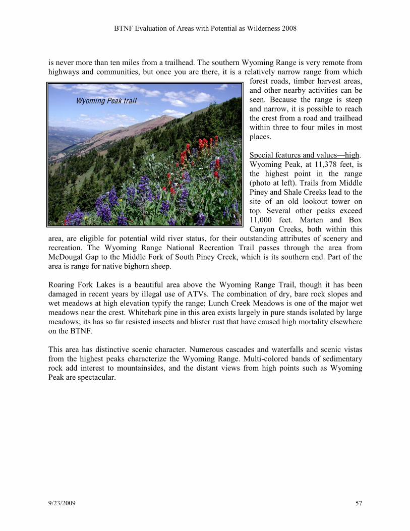
BTNF Evaluation of Areas with Potential as Wilderness 2008
9/23/2009 57
is never more than ten miles from a trailhead. The southern Wyoming Range is very remote from
highways and communities, but once you are there, it is a relatively narrow range from which
forest roads, timber harvest areas,
and other nearby activities can be
seen. Because the range is steep
and narrow, it is possible to reach
the crest from a road and trailhead
within three to four miles in most
places.
Special features and valuesKhigh.
Wyoming Peak, at 11,378 feet, is
the highest point in the range
(photo at left). Trails from Middle
Piney and Shale Creeks lead to the
site of an old lookout tower on
top. Several other peaks exceed
11,000 feet. Marten and Box
Canyon Creeks, both within this
area, are eligible for potential wild river status, for their outstanding attributes of scenery and
recreation. The Wyoming Range National Recreation Trail passes through the area from
McDougal Gap to the Middle Fork of South Piney Creek, which is its southern end. Part of the
area is range for native bighorn sheep.
Roaring Fork Lakes is a beautiful area above the Wyoming Range Trail, though it has been
damaged in recent years by illegal use of ATVs. The combination of dry, bare rock slopes and
wet meadows at high elevation typify the range; Lunch Creek Meadows is one of the major wet
meadows near the crest. Whitebark pine in this area exists largely in pure stands isolated by large
meadows; its has so far resisted insects and blister rust that have caused high mortality elsewhere
on the BTNF.
This area has distinctive scenic character. Numerous cascades and waterfalls and scenic vistas
from the highest peaks characterize the Wyoming Range. Multi-colored bands of sedimentary
rock add interest to mountainsides, and the distant views from high points such as Wyoming
Peak are spectacular.
51/0&64!($'.!*#'&+
Wyoming Peak trail
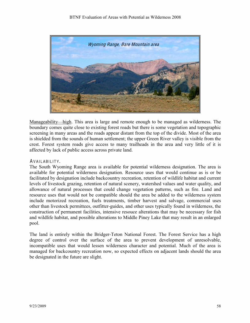
BTNF Evaluation of Areas with Potential as Wilderness 2008
9/23/2009 58
ManageabilityKhigh. This area is large and remote enough to be managed as wilderness. The
boundary comes quite close to existing forest roads but there is some vegetation and topographic
screening in many areas and the roads appear distant from the top of the divide. Most of the area
is shielded from the sounds of human settlement; the upper Green River valley is visible from the
crest. Forest system roads give access to many trailheads in the area and very little of it is
affected by lack of public access across private land. A V A I L A BI L I T Y . The South Wyoming Range area is available for potential wilderness designation. The area is
available for potential wilderness designation. Resource uses that would continue as is or be
facilitated by designation include backcountry recreation, retention of wildlife habitat and current
levels of livestock grazing, retention of natural scenery, watershed values and water quality, and
allowance of natural processes that could change vegetation patterns, such as fire. Land and
resource uses that would not be compatible should the area be added to the wilderness system
include motorized recreation, fuels treatments, timber harvest and salvage, commercial uses
other than livestock permittees, outfitter-guides, and other uses typically found in wilderness, the
construction of permanent facilities, intensive resouce alterations that may be necessary for fish
and wildlife habitat, and possible alterations to Middle Piney Lake that may result in an enlarged
pool.
The land is entirely within the Bridger-Teton National Forest. The Forest Service has a high
degree of control over the surface of the area to prevent development of unresolvable,
incompatible uses that would lessen wilderness character and potential. Much of the area is
managed for backcountry recreation now, so expected effects on adjacent lands should the area
be designated in the future are slight.
Wyoming Range, Bare Mountain area
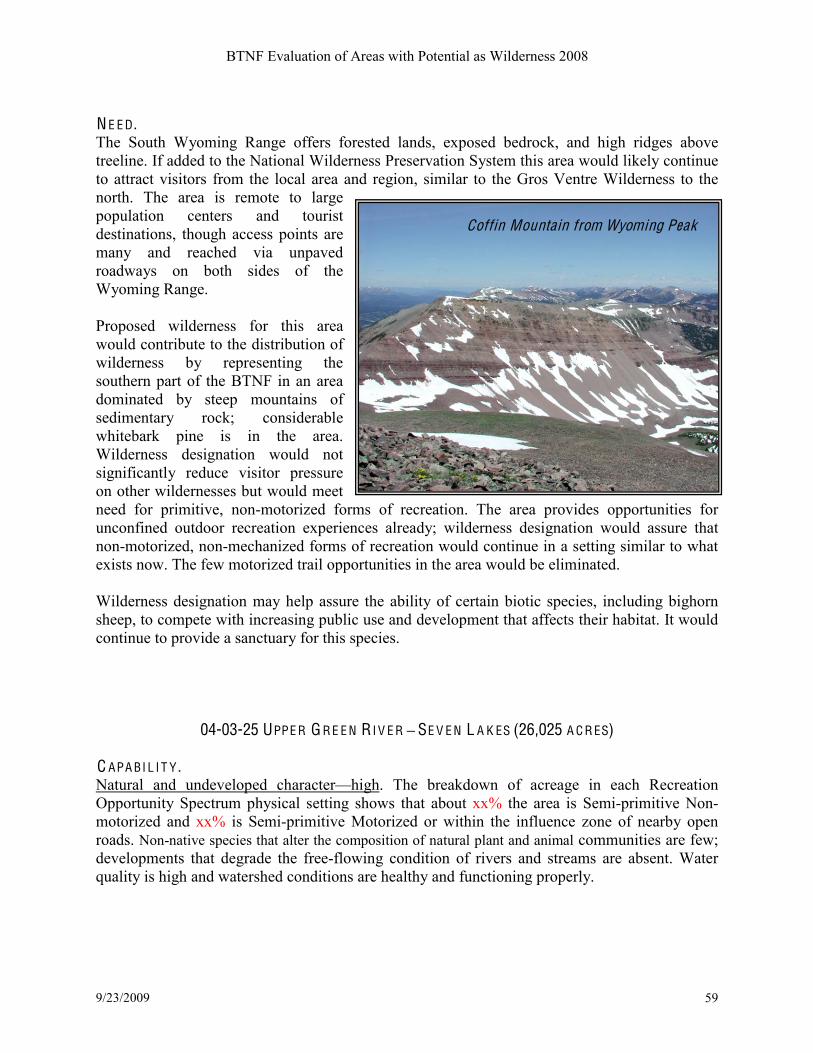
BTNF Evaluation of Areas with Potential as Wilderness 2008
9/23/2009 59
N E E D . The South Wyoming Range offers forested lands, exposed bedrock, and high ridges above
treeline. If added to the National Wilderness Preservation System this area would likely continue
to attract visitors from the local area and region, similar to the Gros Ventre Wilderness to the
north. The area is remote to large
population centers and tourist
destinations, though access points are
many and reached via unpaved
roadways on both sides of the
Wyoming Range. Proposed wilderness for this area
would contribute to the distribution of
wilderness by representing the
southern part of the BTNF in an area
dominated by steep mountains of
sedimentary rock; considerable
whitebark pine is in the area.
Wilderness designation would not
significantly reduce visitor pressure
on other wildernesses but would meet
need for primitive, non-motorized forms of recreation. The area provides opportunities for
unconfined outdoor recreation experiences already; wilderness designation would assure that
non-motorized, non-mechanized forms of recreation would continue in a setting similar to what
exists now. The few motorized trail opportunities in the area would be eliminated.
Wilderness designation may help assure the ability of certain biotic species, including bighorn
sheep, to compete with increasing public use and development that affects their habitat. It would
continue to provide a sanctuary for this species.
04-03-25 UPPE R G R E E N RI V E R ! SE V E N L A K ES (26,025 A C R ES) C APA BI L I T Y . Natural and undeveloped characterKhigh. The breakdown of acreage in each Recreation
Opportunity Spectrum physical setting shows that about xx% the area is Semi-primitive Non-
motorized and xx% is Semi-primitive Motorized or within the influence zone of nearby open
roads. Non-native species that alter the composition of natural plant and animal communities are few;
developments that degrade the free-flowing condition of rivers and streams are absent. Water
quality is high and watershed conditions are healthy and functioning properly.
Coffin Mountain from Wyoming Peak

BTNF Evaluation of Areas with Potential as Wilderness 2008
9/23/2009 60
Outstanding opportunities for solitude and
primitive, unconfined recreationKhigh. This area
is distant from major population centers and just
getting to the margins of the area requires a long
drive over gravel and dirt roads. The area
provides a feeling of being alone or remote from
civilization, and away from trailheads and
mainline trails, there are places within the area
where there is little chance of meeting another
party. It is contiguous with the Bridger and
Fitzpatrick Wildernesses. There is an opportunity
to use self-reliance skills in navigation and
backcountry survival. Physical ability,
orienteering, and outdoor skills are necessary to
safely recreate in much of the area.
Special features and valuesKhigh. A&#*/.&0! 35!
($*&.&0*! ($2)/1&! *,&! 6#$+! >3*,3)&0! #$1! >3$10C!
9&4&$! U#<&0C! %)#2(#))+! 023/.&1! %.#$(*(2! *&..#($C!
&@*&$0(4&! #.�! 35! ,(%,T&)&4#*(3$! %.#00)#$1C!
>3>/)#.!2#6>0(*&0!#$1!.3/*&0!($*3!9&4&$!U#<&0!I#0($!#$1!;.(>)&!F(4(1&!7&#<C!#$1!E3#.($%!A3.<!
I#0($-!E3#.($%!A3.<!B.&&<!(0!#!2#$1(1#*&!8()1!#$1!92&$(2!E(4&.-!L$(3$!7#00C!=,()&!$3*!>#.*!35!
*,&!#.&#!=(*,!=()1&.$&00!>3*&$*(#)C!(0!#!,(0*3.(2!)#$16#.<!$&#.'+-!7#.*!35!*,&!B3$*($&$*#)!F(4(1&!
M#*(3$#)!92&$(2!;.#()!>#00&0!*,.3/%,!*,(0!#.&#-!K6>3.*#$*!,#'(*#*!53.!'(%!%#6&!#$1!3*,&.!=()1)(5&!
(0!53/$1!,&.&-!D.(JJ)+!'&#.0!#$1!=3)4&0!#.&!'&%($$($%!*3!6#<&!/0&!35!*,&!#.&#C!634($%!5.36!*,&!
$3.*,!#$1!=&0*H!>.3$%,3.$0!/0&!*,&!#.&#!#0!0/66&.!.#$%&!#$1!#0!#!6(%.#*(3$!23..(13.!'&*=&&$!
*,&!/>>&.!D.&&$!E(4&.!#$1!*,&!8($1!E(4&.!4#))&+-!
ManageabilityKmoderate. The area is contiguous with two existing wildernesses on the east and
has topographic features that would be useful to help delineate any future wilderness. However,
much of the terrain and the open nature of the western part of the high country would make it
difficult to manage as wilderness and prevent illegal uses. Parts of the area are valued by 4WD
and ATV riders for its remoteness, scenery, and access to lakes; these uses would be displaced if
the area were made wilderness, but terrain features make it possible to designate part of the area
without changing motorized use on the most popular open routes.
A V A I L A BI L I T Y . The area is available for potential wilderness designation. Resource uses that would continue as
is or be facilitated by designation include backcountry recreation, retention of wildlife habitat
and current levels of livestock grazing, retention of natural scenery, watershed values and water
quality, and allowance of natural processes that could change vegetation patterns, such as fire.
Land and resource uses that would not be compatible should the area be added to the wilderness
system include motorized recreation, fuels treatments, timber harvest and salvage, commercial
uses other than livestock permittees, outfitter-guides, and other uses typically found in
Ponds near Union Pass
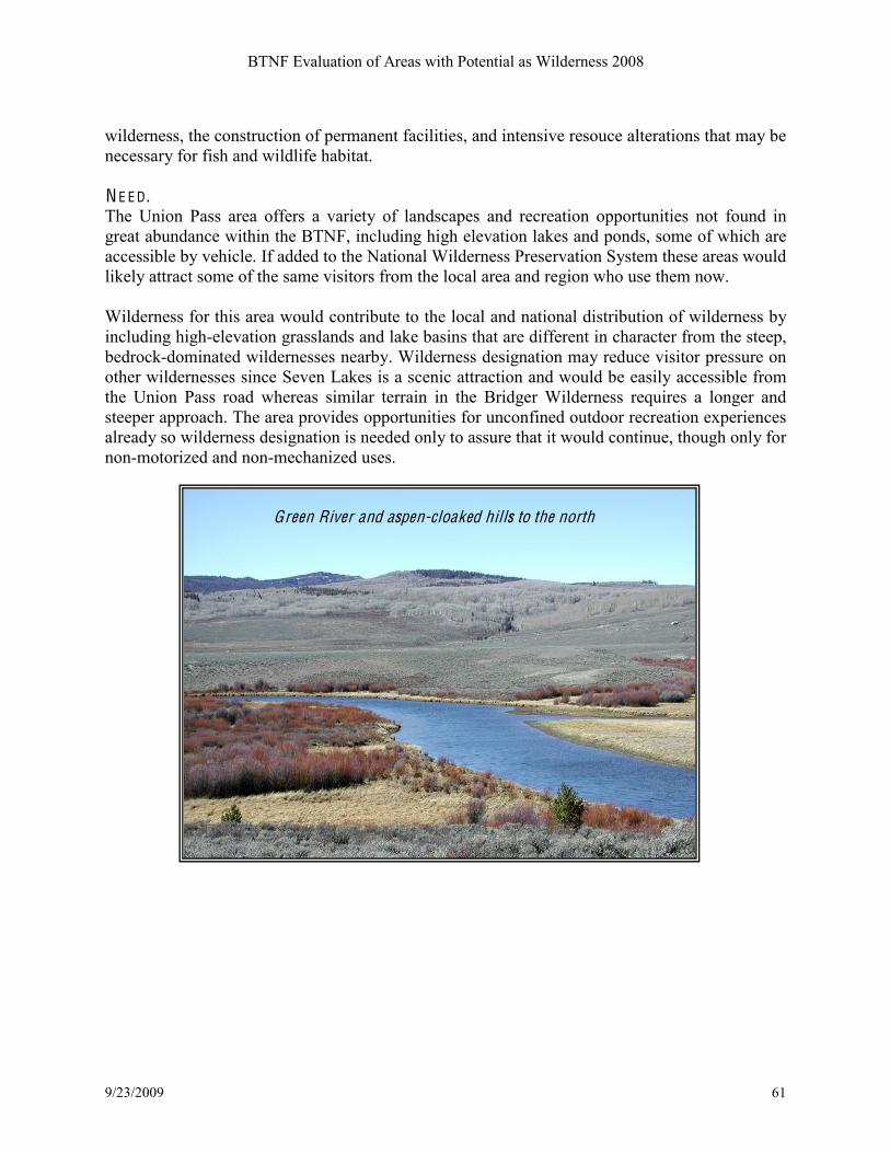
BTNF Evaluation of Areas with Potential as Wilderness 2008
9/23/2009 61
wilderness, the construction of permanent facilities, and intensive resouce alterations that may be
necessary for fish and wildlife habitat.
N E E D . The Union Pass area offers a variety of landscapes and recreation opportunities not found in
great abundance within the BTNF, including high elevation lakes and ponds, some of which are
accessible by vehicle. If added to the National Wilderness Preservation System these areas would
likely attract some of the same visitors from the local area and region who use them now. Wilderness for this area would contribute to the local and national distribution of wilderness by
including high-elevation grasslands and lake basins that are different in character from the steep,
bedrock-dominated wildernesses nearby. Wilderness designation may reduce visitor pressure on
other wildernesses since Seven Lakes is a scenic attraction and would be easily accessible from
the Union Pass road whereas similar terrain in the Bridger Wilderness requires a longer and
steeper approach. The area provides opportunities for unconfined outdoor recreation experiences
already so wilderness designation is needed only to assure that it would continue, though only for
non-motorized and non-mechanized uses.
Green River and aspen-cloaked hills to the north

BTNF Evaluation of Areas with Potential as Wilderness 2008
9/23/2009 62
04-03-26 L I T T L E SH E EP M O UN T A IN (13,690 A C R ES) C APA BI L I T Y . Natural and undeveloped characterKlow. The breakdown of acreage in each ROS physical
setting shows that about half of the area is SPNM and half is SPM or within the influence zone
of nearby roads. "/2,! 35! *,&! #.&#! (0!
/$1(0*/.'&1C!=(*,! )(**)&! .&2.&#*(3$! /0&! #$1! 5&=!
*.#()0-!;,&.&!(0!#!0*&&>C!>.(6(*(4&!.3#1!)($%!*3!
#! )33<3/*! 0(*&! #*! *,&! 0/66(*! 35! U(**)&! 9,&&>!
"3/$*#($C!2/..&$*)+!used as a hiking trail. None
of the area is far from an open forest road,
including the Green River Lakes road with its
attendant traffic.
Outstanding opportunities for solitude and
primitive, unconfined recreationKmoderate.
Considering the size of the area and its
proximity to roaded areas, the opportunity for
solitude is high and primitive recreation can be
found. Access is difficult; the Moose-Gypsum
Road is rough in places and trails are few. The
view from the summit of Little Sheep Mountain
is a spectacular attraction.
Special features and valuesKmoderate. ;,&!
>.(6#.+! 5&#*/.&! 35! ($*&.&0*! (0! *,&! 0/66(*! 35! U(**)&! 9,&&>!"3/$*#($! 5.36!=,(2,! 4(&=0! 35! *,&!
D.&&$!E(4&.C! ;30(! I#0($C! #$1! $3.*,&.$!I.(1%&.!8()1&.$&00! 2#$! '&! ,#1! #5*&.! #! .&)#*(4&)+! 0,3.*!
,(<&-!7#.*!35!*,&!D.&&$!E(4&.!23..(13.C!#!2#$1(1#*&!8()1!#$1!92&$(2!E(4&.C!(0!=(*,($!*,&!#.&#-
ManageabilityKlow. ;,(0! #.&#!=3/)1! '&! 1(55(2/)*! *3!6#$#%&! #0!=()1&.$&00! '&2#/0&! (*! (03)#*&1!
5.36!3*,&.!'#2<23/$*.+!#.�!'+!.3#10-
A V A I L A BI L I T Y . Parts of the area are not available for wilderness because of isolation from larger primitive areas,
and commitment by the BTNF to other resource values, including management of vegetation to
improve habitat for migrating pronghorns. This area offers a scenic viewpoint with views of the
nearby Green River and Bridger Wilderness and offers a counterpoint to the large, remote, and
rugged wilderness lands nearby.
N E E D . The need for wilderness designation in this area is not great; it would not reduce pressure on the
nearby Bridger Wilderness if designated. Wilderness for this area would not contribute unique
landforms or biotic communities nor add appreciably to the local and national distribution of
wilderness.
Little Sheep Mountain
BTNF Evaluation of Areas with Potential as Wilderness 2008
9/23/2009 63
04-03-27 N E W F O R K (10,186 A C R ES) C APA BI L I T Y . Natural and undeveloped characterKmoderate. The breakdown of acreage in each ROS physical
setting shows that about 40% of the area is SPNM, and 60% SPM or within the influence area of
nearby roads. Though this area is adjacent to the Bridger Wilderness, it is narrow and penetrated
by existing roads, some of which are being considered for future closure, but they remain open at
this time. Past timber sale areas are evident in some places, but they are growing back and for the
most part they do not detract from the natural appearance. The area includes foothills to the
Wind River Range, with open grassy slopes, aspen, and conifer forest; it is favored by elk for
calving and provides habitat for many other wildlife species, including grizzly bears. Non-native
species that alter the composition of the plant and animal communities are few; water quality is
high, and developments are absent outside of the road network. Lights, the sight of buildings,
and sounds of traffic on the nearby roads are evident from many parts of this area, but they are
not highly intrusive.

Outstanding opportunities for solitude and primitive, unconfined recreationKmoderate. The area
does not include mainline trails so recreation use is relatively light except for the area
immediately surrounding New Fork Lakes. Boulder Basin and other little-used parts of the
Bridger Wilderness are accessible
through this area.
Special features and valuesK
moderate. Other than the scenic
valley of New Fork Lake, most of
this area is typical for the west
slope of the Wind River Range. It
is known as a place for wildlife
and few people, and as a local
recreation area.
ManageabilityKlow. This area
would be difficult to manage as
wilderness because of its front country nature and proximity to the Green River Lakes Road and
New Fork Lake. A number of open roads penetrate the area, giving access to hunters, firewood
gatherers, and other recreation uses. There are not good topographic or vegetation screening
opportunities to describe a boundary for an area that could be managed as wilderness. A V A I L A BI L I T Y . Most of the area is available for potential wilderness designation. Resource uses that would
continue as is or be facilitated by designation include backcountry recreation, retention of
wildlife habitat and current levels of livestock grazing, retention of natural scenery, watershed
values and water quality, and allowance of natural processes that could change vegetation
patterns, such as fire. Land and resource uses that would not be compatible should the area be
added to the wilderness system include motorized recreation, fuels treatments, timber harvest and
salvage, commercial uses other than livestock permittees, outfitter-guides, and other uses
typically found in wilderness, the construction of permanent facilities, and intensive resouce
alterations that may be necessary for fish and wildlife habitat.
The land is entirely within the Bridger-Teton National Forest. The Forest Service has a high
degree of control over the surface of the area to prevent development of unresolvable,
incompatible uses that would lessen wilderness character and potential.
N E E D . The area is remote to large population centers and tourist destinations, but the high use levels in
the Bridger Wilderness indicate this is not a deterrent to recreation. Adding this sliver of country
to the Bridger Wilderness would not be expected to reduce crowding elsewhere. Though
important wildlife habitat, the area is already being managed to enhance the habitat, and fire
projects that could continue to benefit wildlife may be constrained if this area were added to the
wilderness. Part of this area is also considered wildland-urban interface and fuels treatment
necessary to protect private structures would be constrained by wilderness designation here.
New Fork area ( foothills) from Mosquito Lake
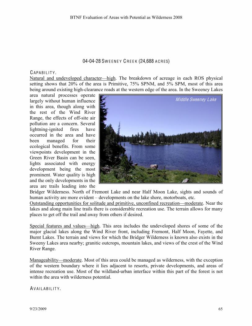
BTNF Evaluation of Areas with Potential as Wilderness 2008
9/23/2009 65
04-04-28 SW E E N E Y C R E E K (24,688 A C R ES)
C APA BI L I T Y . Natural and undeveloped characterKhigh. The breakdown of acreage in each ROS physical
setting shows that 20% of the area is Primitive, 75% SPNM, and 5% SPM, most of this area
being around existing high-clearance roads at the western edge of the area. In the Sweeney Lakes
area natural processes operate
largely without human influence
in this area, though along with
the rest of the Wind River
Range, the effects of off-site air
pollution are a concern. Several
lightning-ignited fires have
occurred in the area and have
been managed for their
ecological benefits. From some
viewpoints development in the
Green River Basin can be seen,
lights associated with energy
development being the most
prominent. Water quality is high
and the only developments in the
area are trails leading into the
Bridger Wilderness. North of Fremont Lake and near Half Moon Lake, sights and sounds of
human activity are more evident B developments on the lake shore, motorboats, etc.
Outstanding opportunities for solitude and primitive, unconfined recreationKmoderate. Near the
lakes and along main line trails there is considerable recreation use. The terrain allows for many
places to get off the trail and away from others if desired.
Special features and valuesKhigh. This area includes the undeveloped shores of some of the
major glacial lakes along the Wind River front, including Fremont, Half Moon, Fayette, and
Burnt Lakes. The terrain and views for which the Bridger Wilderness is known also exists in the
Sweeny Lakes area nearby; granitic outcrops, mountain lakes, and views of the crest of the Wind
River Range.
ManageabilityKmoderate. Most of this area could be managed as wilderness, with the exception
of the western boundary where it lies adjacent to resorts, private developments, and areas of
intense recreation use. Most of the wildland-urban interface within this part of the forest is not
within the area with wilderness potential.
A V A I L A BI L I T Y .
Middle Sweeney Lake

BTNF Evaluation of Areas with Potential as Wilderness 2008
9/23/2009 66
Most of the area is available for potential wilderness designation. Resource uses that would
continue as is or be facilitated by designation include backcountry recreation, retention of
wildlife habitat and current levels of livestock grazing, retention of natural scenery, watershed
values and water quality, and allowance of natural processes that could change vegetation
patterns, such as fire. Land and resource uses that would not be compatible should the area be
added to the wilderness system include motorized recreation, fuels treatments, timber harvest and
salvage, commercial uses other than livestock permittees, outfitter-guides, and other uses
typically found in wilderness, the construction of permanent facilities or expansion of existing
resort areas into the area, and intensive resouce alterations that may be necessary for fish and
wildlife habitat. Boundary adjustments could accommodate incompatible uses on the margins of
this area.
The land is entirely within the Bridger-Teton National Forest. The Forest Service has a high
degree of control over the surface of the area to prevent development of unresolvable,
incompatible uses that would lessen wilderness character and potential.
N E E D . The area is adjacent to the Bridger Wilderness, which receives high recreation use in spite of
being remote to large population centers. Adding parts of this area to the Bridger Wilderness
would be unlikely to divert use from other attractions; Sweeney Lakes are already popular for
camping and being outside the wilderness they allow for larger parties and thus provide an
opportunity for recreation that is not found in the wilderness. Much of the area is already being
managed for backcountry recreation, wildlife habitat and watershed purposes.
04-03-29 B I G SA ND Y ! SW E E T W A T E R (69,018 A C R ES) C APA BI L I T Y . Natural and undeveloped characterKhigh. The breakdown of acreage in each ROS physical
setting shows that 20% of the area is Primitive, 75% SPNM, and 5% SPM. In winter, most of the
area is SPM, with part of the Continental Divide Snowmobile Trail running from Irish Canyon to
Sioux Pass. Other than the Big Sandy area, this is a low-use part of the Wind River Range, and
much of it appears undisturbed. Exceptions exist in some where alterations to native vegetation
have occurred from domestic livestock grazing and where off-route use of motor vehicles has left
scars in wet meadows.
Outstanding opportunities for solitude and primitive, unconfined recreationKhigh. Much of the
area is remote and wild, especially between Sweetwater Needles and Sioux Pass on the south and
the canyon of the East Fork River on the north. The central part of this area is penetrated by
high-clearance roads and jeep trails, but these generally do not receive heavy use; once away
from the main roads and trails it is possible to gain a high degree of solitude. Challenge and the
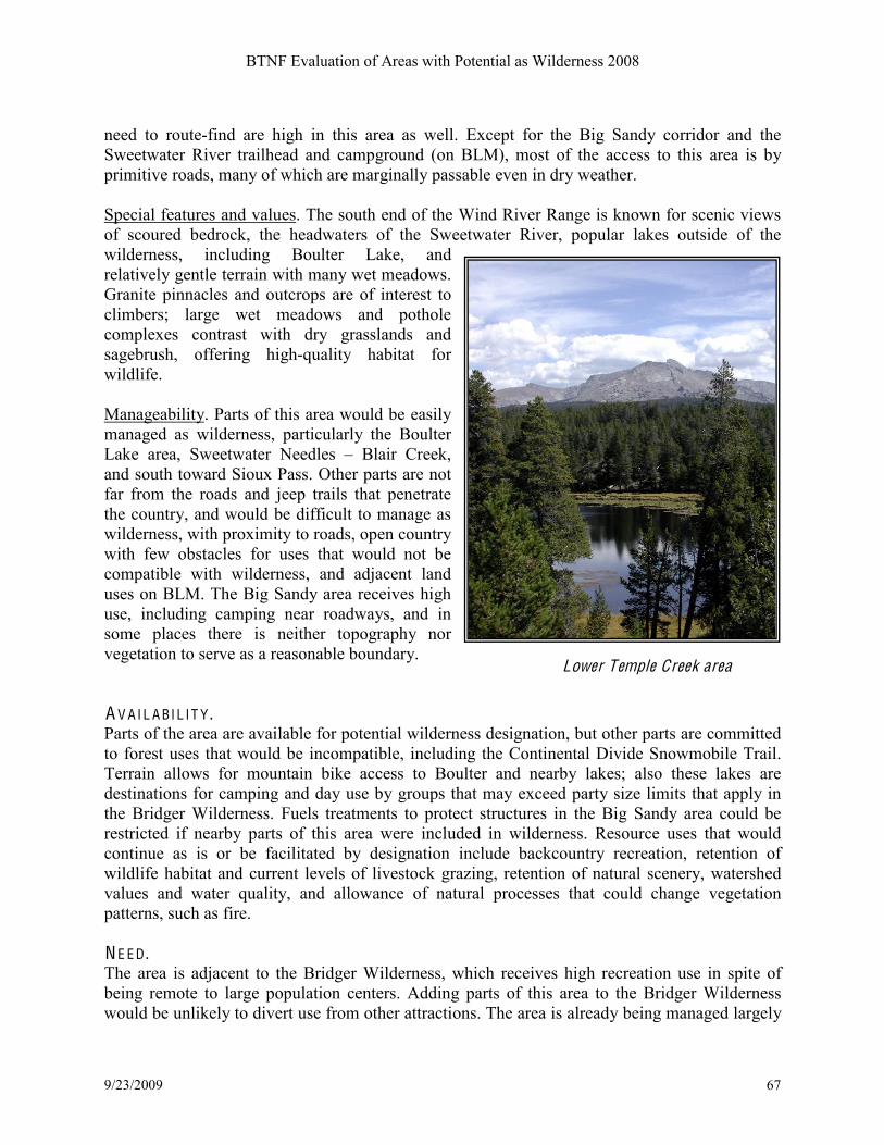
BTNF Evaluation of Areas with Potential as Wilderness 2008
9/23/2009 67
need to route-find are high in this area as well. Except for the Big Sandy corridor and the
Sweetwater River trailhead and campground (on BLM), most of the access to this area is by
primitive roads, many of which are marginally passable even in dry weather.
Special features and values. The south end of the Wind River Range is known for scenic views
of scoured bedrock, the headwaters of the Sweetwater River, popular lakes outside of the
wilderness, including Boulter Lake, and
relatively gentle terrain with many wet meadows.
Granite pinnacles and outcrops are of interest to
climbers; large wet meadows and pothole
complexes contrast with dry grasslands and
sagebrush, offering high-quality habitat for
wildlife.
Manageability. Parts of this area would be easily
managed as wilderness, particularly the Boulter
Lake area, Sweetwater Needles B Blair Creek,
and south toward Sioux Pass. Other parts are not
far from the roads and jeep trails that penetrate
the country, and would be difficult to manage as
wilderness, with proximity to roads, open country
with few obstacles for uses that would not be
compatible with wilderness, and adjacent land
uses on BLM. The Big Sandy area receives high
use, including camping near roadways, and in
some places there is neither topography nor
vegetation to serve as a reasonable boundary. A V A I L A BI L I T Y . Parts of the area are available for potential wilderness designation, but other parts are committed
to forest uses that would be incompatible, including the Continental Divide Snowmobile Trail.
Terrain allows for mountain bike access to Boulter and nearby lakes; also these lakes are
destinations for camping and day use by groups that may exceed party size limits that apply in
the Bridger Wilderness. Fuels treatments to protect structures in the Big Sandy area could be
restricted if nearby parts of this area were included in wilderness. Resource uses that would
continue as is or be facilitated by designation include backcountry recreation, retention of
wildlife habitat and current levels of livestock grazing, retention of natural scenery, watershed
values and water quality, and allowance of natural processes that could change vegetation
patterns, such as fire.
N E E D . The area is adjacent to the Bridger Wilderness, which receives high recreation use in spite of
being remote to large population centers. Adding parts of this area to the Bridger Wilderness
would be unlikely to divert use from other attractions. The area is already being managed largely
Lower Temple Creek area

BTNF Evaluation of Areas with Potential as Wilderness 2008
9/23/2009 68
for backcountry recreation and very low use; the few places that are popular for recreation offer a
contrast to the kinds of use acceptable in the wilderness (Boulter Lake). Addition of this area to
the Bridger Wilderness would not be likely to reduce the pressure on major destinations from
Big Sandy, but would include some features and habitats that are generally underrepresented in
protected areas, including sagebrush/grassland, potholes, and extensive riparian areas. R A R E-I I A rea 3006 L ittle Cottonwood C reek Little Cottonwood Creek was identified as
an Inventoried Roadless Area in 1983,
although at 4,874 acres it does not meet
size criteria for an area of wilderness
potential. It does include a unique and
special geologic feature, the Red Castles
(below). Although not eligible for
consideration as wilderness, this area could
be administratively designated as a way of
recognizing the area.
Red Castles. Note the primitive road on the right. %
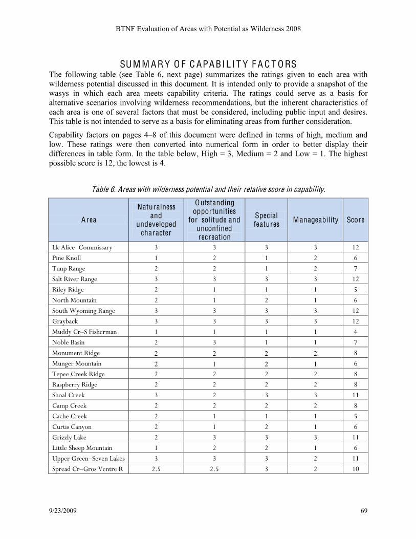
BTNF Evaluation of Areas with Potential as Wilderness 2008
9/23/2009 69
SU M M A R Y O F C APA BI L I T Y F A C T O RS The following table (see Table 6, next page) summarizes the ratings given to each area with
wilderness potential discussed in this document. It is intended only to provide a snapshot of the
wasys in which each area meets capability criteria. The ratings could serve as a basis for
alternative scenarios involving wilderness recommendations, but the inherent characteristics of
each area is one of several factors that must be considered, including public input and desires.
This table is not intended to serve as a basis for eliminating areas from further consideration.
Capability factors on pages 4B8 of this document were defined in terms of high, medium and
low. These ratings were then converted into numerical form in order to better display their
differences in table form. In the table below, High = 3, Medium = 2 and Low = 1. The highest
possible score is 12, the lowest is 4.
Table 6. Areas with wilderness potential and their relative score in capability.
A rea
Naturalness and
undeveloped character
Outstanding opportunities
for solitude and unconfined recreation
Special features Manageability Score
!"#$%&'(!)*++&,,-./## 0# 0# 0# 0# 12#
3&4(#54*%%## 1# 2# 1# 2# 6#
7849#:-4;(# 2# 2# 1# 2# <#
=-%>#:&?(.#:-4;(### 0# 0# 0# 0# 12#
:&%(/#:&@;(## 2# 1# 1# 1# A#
B*.>C#D*84>-&4## 2# 1# 2# 1# 6#
=*8>C#E/*+&4;#:-4;(## 0# 0# 0# 0# 12#
F.-/G-'"## 0# 0# 0# 0# 12#
D8@@/#).!=#H&,C(.+-4### 1# 1# 1# 1# I#
B*G%(#J-,&4## 2# 0# 1# 1# <#
D*48+(4>#:&@;(## 2 2 2 2 K#
D84;(.#D*84>-&4## 2 1 2 1 6#
7(9((#).(("#:&@;(## 2# 2# 2# 2# K#
:-,9G(../#:&@;(## 2# 2# 2# 2# K#
=C*-%#).(("## 0# 2# 0# 0# 11#
)-+9#).(("## 2# 2# 2# 2# K#
)-'C(#).(("## 2# 1# 1# 1# A#
)8.>&,#)-4/*4## 2# 1# 2# 1# 6#
F.&LL%/#!-"(## 2# 0# 0# 0# 11#
!&>>%(#=C((9#D*84>-&4## 1# 2# 2# 1# 6#
M99(.#F.((4!=(?(4#!-"(,## 0# 0# 0# 2# 11#
=9.(-@#).!F.*,#N(4>.(#:# 2OA# 2OA# 0# 2# 1P#

BTNF Evaluation of Areas with Potential as Wilderness 2008
9/23/2009 70
A rea
Naturalness and
undeveloped character
Outstanding opportunities
for solitude and unconfined recreation
Special features Manageability Score
3-'&Q&'#R#J%-'".*'"#).(("## 0# 2# 0# 2# 1P#
F-44(>>#S&%%,R=9.&4;#).## 2# 2# 2# 2# K#
3-%&,-@(,## 0# 0# 0# 0# 12#
3C&%%&9,#:&@;(## 2# 2# 2# 2# K#
B(T#H*."# 2# 2# 2# 1# <#
=T((4(/#).(("## 0# 2# 0# 2# 1P#
J&;#=-4@/#!#=T((>T->(.## 0# 0# 0# 2OA# 11OA#
Displaying the areas with wilderness potential in groupings by their cumulative ratings gives a
picture of the relatively large amount of non-wilderness backcountry within the BTNF that has
high capability as wilderness. Figure 1 below shows the total acreage and percent of the areas
with wilderness potential that fall into these high categories, as well as the smaller percentage of
acreage with wilderness potential that has low to moderate capability factors.
F igure 1. Areas with wilderness potential grouped into capability categories.
56%30%
9% 5%
Highest
High
Moderate
Low
Highest 880,395 acres H igh 458,030
Moderate 131,695 Low 74,359

BTNF Evaluation of Areas with Potential as Wilderness 2008
9/23/2009 71
The capability ratings show that naturalness and opportunities for solitude and unconfined
recreation are directly related to the size of the area. Those areas that scored highly are the
largest areas with wilderness potential, as illustrated in Figure 2. Most of the low to moderately
capable areas are relatively small, close to human activities, and isolated from other wild areas
by roads or other developments.
F igure 2. Comparison of average area size with its capability as wilderness.
0
20,000
40,000
60,000
80,000
100,000
120,000
140,000
160,000
180,000
Highest High Moderate Low
Average size (acres)
A R E AS W I T H W I L D E RN ESS PO T E N T I A L A ND F O R EST PL A N R E V ISI O N
Possible management scenarios for areas with wilderness potential under the revised forest plan
will respond to the inherent wilderness values of each area, public opinion, and prior existing
rights to permit holders or commitments made to other forest uses (availability). Desired
conditions from the draft plan revision document that would change the character of these areas
the least are shown in Table 7 below.
onds near Unio Pass

BTNF Evaluation of Areas with Potential as Wilderness 2008
9/23/2009 72
D ESIR E D C O NDI T I O N D ESC RIPT I O N
R E C O M M E ND E D W I L D E RN ESS
Those parts of the forest meeting national criteria for potential
wilderness and determined to be capable, available, and needed for
additions to the National Wilderness Preservation System. The
7-&'",!"#/68'6,-&/'*#&-%*1'""#%&'%"<#V-6+&'""/-6%112#*'"/+6%,'*#
Wilderness Study Areas (Palisades and Shoal Creek), and numerous
large backcountry areas are potential candidates.
A R E AS W I T H N O PUB L I C USE T O PR O T E C T SPE C I A L R ESO UR C ES
Seasonally closed big game winter ranges and the small area around
Kendall Warm Springs are currently the only areas closed for this
purposes.
UNR O A D E D B A C K C O UN T R Y
Remote, unmodified, natural areas with little obvious on-site
management other than signing, trail work and field patrols; no
motorized travel takes place here. High to moderate probability of
solitude; some evidence of others but these areas generally have an
open, uncrowded character.
E L I G IB L E W I L D A ND SC E NI C RI V E RS
Rivers found eligible through a systematic inventory for potential
designation as Wild, Scenic, or Recreational Rivers under the 1968
Wild and Scenic Rivers Act. Average corridor width is ! mile, " mile
on either side of the river.
R ESE A R C H N A T UR A L A R E AS
Areas designated for their research value as representations of specific
habitat types in the Middle Rocky Mountains. There are four RNAs
within the forest: Osborn Mountain, Gros Ventre, Afton Front, and
Swift Creek. Other areas on the forest could be considered.
N A T I O N A L N A T UR A L L A ND M A R KS
A nationally significant natural area that has been designated by the
Secretary of the Interior. To be nationally significant, the feature or
site must be a prime example of a type of biotic community or
geologic feature. The only National Natural Landmark within the
BTNF is Two Ocean Pass, in the Teton Wilderness. Several potential
landmarks have been identified within the Forest
B A C K C O UN T R Y A R E AS T H A T IN C L UD E SO M E O F F-R O A D V E H I C L E USE
Predominately natural areas with designated motor vehicle routes, on
forest system roads and trails. Not all trails within the area are
motorized and there are places within these semi-primitive motorized
areas where one can find quiet and solitude.
F R O N T-C O UN T R Y R E C R E A T I O N A R E AS N E A R C O M M UNI T I ES
Predominately natural in appearance with minor improvements to
accommodate significant recreation use. May have a dense trail
network or other facilities; semi-primitive in appearance but without
size or remoteness typical of such settingsKexamples are Cache
Creek, and some of the Teton Pass area.

A R E AS W I T H W I L D E RN ESS PO T E N T I A L BRID G E R-T E T O N N A T I O N A L F O R EST
Summary table 7/10/07
Are
a N
ame
RA
RE
II
num
ber
Cur
rent
ID
num
ber
Acr
es f
rom
la
st
inve
ntor
y [1
]
GIS
ca
lcul
ated
ac
reag
es
from
sam
e in
vent
ory
Diff
eren
ces
in a
cres
du
e to
GIS
Cur
rent
ar
ea w
ith
Wild
erne
ss
pote
ntia
l (a
cres
) [2]
Net
cha
nge
in a
crea
ge
due
to
man
agem
ent
act
ions
; ot
her
com
men
ts
Lake Alice -
Commissary
Ridge
3001
04-03-01,
04-03-02,
and 04-03-
05
179,920 156,305 and 10,243 -13,372 149,423 and
10,960
-6165 acres due to timber
harvest and map protocol
Nugent Park -
Hams Fork 3001A
04-03-03
and 04-03-
04
21,590 21,199 -391 6854
-14,345 acres due to correcting
open road layer and map
protocol
Salt River
Range 3002 04-03-06 259,270 238,766 -20,504 239,480
714 acres added due to
correcting road layer and map
protocol
Riley Ridge 3003 04-03-07 17,600 4,763 -12,837 14,090
9,327 acres added due to
correcting road layer and map
protocol
North
Mountain 3004 04-03-08 8,564 9,809 1,245 5,309
-4499 acres due to correcting
road layer and map protocol
South
Wyoming
Range
3005 04-03-09 76,191 85,706 9,515 96,538
10,832 acres added due to
correcting road layer and map
protocol
Little
Cottonwood Cr 3006 n/a 4,874 5,459 585 0
No area larger than 5,000
acres resulted upon applying
corrected road layer.
Grayback
3007 04-03-10 315,647 300,928 -14,719 318,466
17,538 acres added due to
correcting road layer and
mapping protocol.
Monument
Ridge 3008 04-03-11 17,380 17,706 326 16,419
-1,287 acres. Reflects buffer
around boundary roads and
private land
Munger Mtn. 3009 04-03-12 12,900 12,813 -77 9,834
-2,979 with the omission of
area south of Fall Creek Rd,
which bisects this area.

BTNF Evaluation of Areas with Potential as Wilderness 2008
9/23/2009 74
Gros Ventre 3010
04-03-13
04-03-14
04-03-15
04-03-32
04-03-33
435,320 139,133 includes
Shoal Creek WSA -35,011 140,704
1544 acres added to what
remains roadless; -285,413
acres from original mapping
due to legislation (Gros Ventre
Wilderness)
Little Sheep
Mtn 3011 04-03-16 17,300 14,851 -2,449 12,096
-2,755 acres due to timber
harvest and correction of map
layer
Mosquito Lake
B Seven Lakes 3012 04-03-17 30,014 51,967 21,953 11,993
-39,974 acres due to timber
harvest, exclusion of extrusion
and correction of road map.
Spread Creek B
Gros Ventre
River
3013 04-03-18 172,821 165,972 -6,849 215,146 49,174 acres added due to map
protocol
Pacific -
Blackrock Cr 3014 04-03-19 26,370 24,236 -2,134 22,100
-2,136 acres due to following
map protocol
Teton Corridor 3015 n/a 28,156 277 (TH areas) 0 0
All that remains of this area
are three trailheads. 27,879
acres added to Teton
Wilderness
Gannett Hills B
Spring Creek 3901 04-03-20 46,400 45,449 -951 38,443
Removed a non-contiguous
area
Palisades 3902 04-03-21 81,872 76,783 -4,984 80,903 4,015 acres added due to
corrected road layer.
Phillips Ridge 3903 04-03-22 9,900 10,110 210 9,433
-677 acres due to corrected
road layer and applying
protocol
West slope
Winds 3904
04-03-23
04-03-24
04-03-25
[3] 143,020 n/a 108,328
-34,692 acres; much of the
original RARE-II area is now
part of the Bridger Wilderness.
! Summary of inventoried roadless areas and areas with wilderness potential.
![1] All of these acreages are from the 1983 BTNF roadless area re-evaluation.
[2] Areas with wilderness potential determined using R4 protocol for inventory and refinement of GIS maps. Changes are still being made that will result in
new figures (for example, motorized lakes along Wind River front have not yet been removed from areas with wilderness potential).
[3] No acreage figure for this area was included in the 1983 document; however, most of the roadless area was added to the Bridger Wilderness (Wyoming
Wilderness Act, 1984).

BTNF Evaluation of Areas with Potential as Wilderness 2008
9/23/2009 75
IN V E N T O RI E D R O A D L ESS A R E AS ! R A R E-I I O N L Y BRID G E R-T E T O N N A T I O N A L F O R EST
Summary table
A rea Name R A R E I I number
G IS calculated acreages Notes and comments
Lake Alice - Commissary Ridge 3001 166,548 Excludes area east of Middle Ridge and a small area near Big Park, E side of Absaroka Ridge
and a wide corridor south of LaBarge Creek
Nugent Park - Hams Fork 3001A 21,199 Mapped as solid roadless except for formerly private lands
Salt River Range 3002 238,766
Excludes Poison Mdws, much of Clear Creek and lower Spring Creek, South Three Forks Cr to
Meadows Creek east of the Way Trail, lower White Cr, lower Murphy Cr, and Squaw Creek.
These are already mostly cut over.
Riley Ridge 3003 4,763 GIS acres show less than 5,000 B this may be a candidate for a technical correction.
North Mountain 3004 9,809 Mapped as solid roadless with no exclusions.
South Wyoming Range 3005 85,706 Excludes upper Greys from Tri-Basin Divide to lower Kinney Creek, and much of the east slope in
a wide corridor along the Bare Pass Road and the Cottonwoods.
Little Cottonwood Cr 3006 5,459 Mapped as solid roadless
Grayback 3007 300,928
Excludes Bug Creek, Blind Bull summit area, Blind Trail to Bull Hollow in the Little Greys, a
large area west of Cliff Creek from Lime to Cabin Creeks, and much of the east side from the
upper Hoback River to North Horse Creek, and Maki Creek.
Monument Ridge 3008 17,706 Mapped as solid roadless
Munger Mtn. 3009 12,813 Mapped as solid roadless
Gros Ventre 3010 139,133 includes
Shoal Creek WSA
Much of this area is now part of the Gros Ventre Wilderness (286,413 acres according to GIS);
another 32,374 is the Shoal Creek Wilderness Study Area. Excludes North Beaver Creek to the
Rim, N Fk Fisherman Creek, and south half of Curtis Canyon area.
Little Sheep Mtn 3011 14,851 Excludes private land and area already entered for timber via Moose-Gypsum Road
Mosquito Lake B Seven Lakes 3012 51,967 Excludes corridor of Green River Lakes Road and much of the cut areas between upper Bacon
Creek and Lake of the Woods
Spread Creek B Gros Ventre River 3013 165,972 Excludes large areas already entered for timber or oil/gas exploration, including closed roads in N
Fk Fish Creek, Spread Creek, etc.
Pacific - Blackrock Cr 3014 24,236 Mapped as solid roadless
Teton Corridor 3015 277 (TH areas) This RARE-II area essentially became part of the Teton Wilderness, except for trailheads
Gannett Hills B Spring Creek 3901 45,449 Mapped as solid roadless
Palisades 3902 76,873 Excludes lower N Fk Fall Creek (but not all cutover areas) and Mosquito B Mill Creek area
Phillips Ridge 3903 10,110 Excludes area SE of power line ROW
West slope Winds 3904 143,020 Some of this RARE-II area became part of the Bridger Wilderness, leaving scattered sections.
Exclusions from roadless in Boulder Basin, New Fork Lake area, and Sweetwater River.

R A R E-I I compared with C URR E N T IN V E N T O R Y BRID G E R-T E T O N N A T I O N A L F O R EST
Total acreage per area
A rea name
G IS calculated acreages from
R A R E-I I inventory
Cur rent area with
Wilderness potential
Lake Alice - Commissary Ridge 166,548 160,383
Nugent Park - Hams Fork 21,199 6854
Salt River Range 238,766 239,480
Riley Ridge 4,763 14,090
North Mountain 9,809 5,309
South Wyoming Range 85,706 96,538
Little Cottonwood Cr 5,459 0
Grayback 300,928 318,466
Monument Ridge 17,706 16,419
Munger Mtn. 12,813 9,834
Gros Ventre 139,133 140,704
Little Sheep Mtn 14,851 12,096
Mosquito Lake B Seven Lakes 51,967 11,993
Spread Creek B Gros Ventre River 165,972 215,146
Pacific - Blackrock Cr 24,236 22,100
Teton Corridor 277 0
Gannett Hills B Spring Creek 45,449 38,443
Palisades 76,873 80,903
Phillips Ridge 10,110 9,433
West slope Winds 143,020 108,328
1,535,600 1,506,519