Brian Hewes, 2012 Using GIS to Improve Sewer Line Maintenance
6
USING GIS TO IMPROVE SEWER LINE MAINTENANCE TO PREVENT SANITARY SEWER OVERFLOWS Brian Hewes, Department of Earth Sciences, University of South Alabama, Mobile, Al 36688. Email: [email protected] . Sanitary sewer overflows are extremely detrimental to a surrounding watershed. An overflow occurs when volume exceeds capacity. There are several causes of an overflow; one of these causes is poorly maintained sewer clean out stations, which lead to blockages. Blockages are caused by grease buildup or other foreign objects. These clean out stations need to be serviced regularly to avoid blockages and to provide a more free flowing system. By using GIS, with a network analyst extension, I was able to design routes for a fleet of MAWSS (Mobile Area Water and Sewer System) trucks to cover all of these sewer clean outs in the most timely efficient way. These routes were designed based on where the clean outs are and the number of trucks that will go out cleaning these stations. Historic traffic data was also gathered from the City of Mobile. By being more efficient cleaning the sewer lines, the number of sanitary sewer overflows should be reduced, thus improving the water quality of the surrounding watershed. Keywords: sanitary sewer overflow, network analyst, sewer system Introduction: Water quality has and will always be a major area of concern for Dog River Clearwater Revival. Any event that has a negative impact on the water also has a negative impact on the entire community. One of these negative events the city is currently trying to combat is sanitary sewer overflows (SSO). A sanitary sewer overflow is basically a raw sewage spill out of a manhole into streets or surrounding streams (Fig.1). This untreated sewage can be very detrimental to the water quality of the surrounding watershed along with the community associated with the watershed. Because SSO’s contain raw sewage, they can carry bacteria and viruses. The diseases they may cause range in severity from mild gastroenteritis (causing stomach cramps and diarrhea) to life-threatening ailments such as cholera, dysentery, infections hepatitis, and severe gastroenteritis (EPA, 1996). They are caused when the volume of water or sewage increases to a higher demand than the sewer systems capacity, or when the system fails to operate at full capacity due to a blockage or a break in the line. Jerrod Frederking showed
Transcript of Brian Hewes, 2012 Using GIS to Improve Sewer Line Maintenance

USING GIS TO IMPROVE SEWER LINE MAINTENANCE TO PREVENT SANITARY SEWER OVERFLOWS
Brian Hewes, Department of Earth Sciences, University of South Alabama, Mobile, Al 36688. Email: [email protected]. Sanitary sewer overflows are extremely detrimental to a surrounding watershed. An overflow occurs when volume exceeds capacity. There are several causes of an overflow; one of these causes is poorly maintained sewer clean out stations, which lead to blockages. Blockages are caused by grease buildup or other foreign objects. These clean out stations need to be serviced regularly to avoid blockages and to provide a more free flowing system. By using GIS, with a network analyst extension, I was able to design routes for a fleet of MAWSS (Mobile Area Water and Sewer System) trucks to cover all of these sewer clean outs in the most timely efficient way. These routes were designed based on where the clean outs are and the number of trucks that will go out cleaning these stations. Historic traffic data was also gathered from the City of Mobile. By being more efficient cleaning the sewer lines, the number of sanitary sewer overflows should be reduced, thus improving the water quality of the surrounding watershed. Keywords: sanitary sewer overflow, network analyst, sewer system
Introduction:
Water quality has and will always be a major area of concern for Dog River Clearwater
Revival. Any event that has a negative impact on the water also has a negative impact on the
entire community. One of these negative events the city is currently trying to combat is sanitary
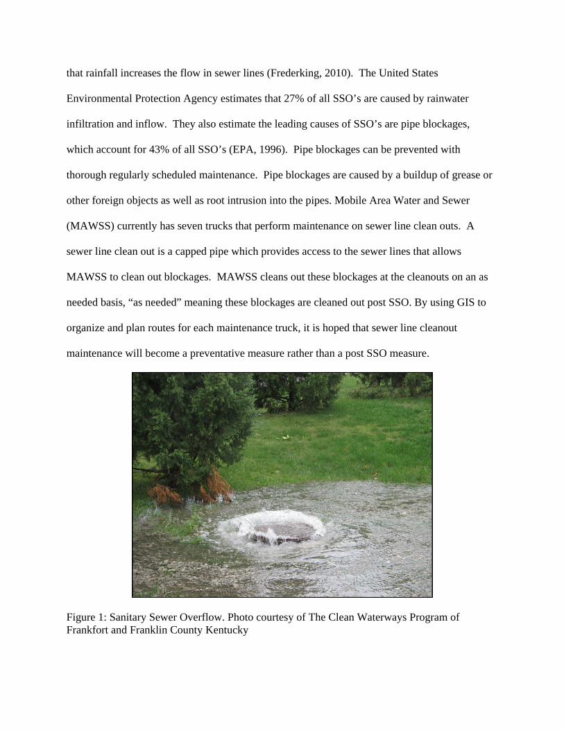
sewer overflows (SSO). A sanitary sewer overflow is basically a raw sewage spill out of a
manhole into streets or surrounding streams (Fig.1). This untreated sewage can be very
detrimental to the water quality of the surrounding watershed along with the community
associated with the watershed. Because SSO’s contain raw sewage, they can carry bacteria and
viruses. The diseases they may cause range in severity from mild gastroenteritis (causing
stomach cramps and diarrhea) to life-threatening ailments such as cholera, dysentery, infections
hepatitis, and severe gastroenteritis (EPA, 1996). They are caused when the volume of water or
sewage increases to a higher demand than the sewer systems capacity, or when the system fails
to operate at full capacity due to a blockage or a break in the line. Jerrod Frederking showed
that rainfall increases the flow in sewer lines (Frederking, 2010). The United States
Environmental Protection Agency estimates that 27% of all SSO’s are caused by rainwater
infiltration and inflow. They also estimate the leading causes of SSO’s are pipe blockages,
which account for 43% of all SSO’s (EPA, 1996). Pipe blockages can be prevented with
thorough regularly scheduled maintenance. Pipe blockages are caused by a buildup of grease or
other foreign objects as well as root intrusion into the pipes. Mobile Area Water and Sewer
(MAWSS) currently has seven trucks that perform maintenance on sewer line clean outs. A
sewer line clean out is a capped pipe which provides access to the sewer lines that allows
MAWSS to clean out blockages. MAWSS cleans out these blockages at the cleanouts on an as
needed basis, “as needed” meaning these blockages are cleaned out post SSO. By using GIS to
organize and plan routes for each maintenance truck, it is hoped that sewer line cleanout
maintenance will become a preventative measure rather than a post SSO measure.
Figure 1: Sanitary Sewer Overflow. Photo courtesy of The Clean Waterways Program of Frankfort and Franklin County Kentucky

Research Question:
Can GIS be used to better organize and more efficiently perform maintenance on sewer
lines in order to prevent sanitary sewer overflows?
Methods:
Arc GIS with a network analyst extension was used to determine the best route for each
truck to take in order to cover the entire sewer system. Throughout this project, I coordinated
with GIS Supervisor at MAWSS, Matt Sanders. First with the aid of Matt Sanders, a shape file
was made containing the exact coordinates and a history of SSO’s at each cleanout location.
Then it was determined under normal conditions that one truck could perform maintenance on
between 6-8 sewer cleanouts in a normal workday. A network data set was created using traffic
data gathered from the City of Mobile’s GIS data. Then a route was created for each truck that
encompassed between 6-8 cleanouts. Each route started and ended at 4725 Moffett Rd, which is
the MAWSS office for sewer operations.
Results:
Seven routes were designed, one for each truck. These routes cover all of the cleanout
locations. If the cleanouts are close in proximity, the route contains eight cleanouts. If the
cleanouts are widely dispersed, there were only six cleanouts within the route. A large map
containing all of the routes was generated (Fig.2), along with smaller more detailed maps for
each individual route (Fig.3). Driving directions with turn-by-turn images can also be generated
for each individual route. All of these routes have been approved by GIS supervisor Matt
Sanders along with the current sewer line maintenance supervisor of MAWSS.

Figure 2: Map of all seven sewer clean out routes.
Figure 3: Detailed map of Route 1.

Conclusion:
Sanitary sewer overflows are very hazardous to the water quality, and they can carry
diseases to those in the surrounding community. These overflows are caused when flow exceeds
capacity. This occurs when either the flow is increased by rain or the capacity is decreased by
blockages. Treatment companies like MAWSS try to combat these overflows caused by
blockages by performing maintenance on sewer line cleanouts. By utilizing the capabilities of
GIS, specifically the network analyst extension, this project has offered streamlined, productive,
thorough process by which the pipes can be cleaned and maintained. The sewer line cleanouts
will not only be used post SSO but these cleanouts will be utilized as preventative measures. If
SSO’s are reduced then the water quality in Dog River should improve.
There were 17 cleanouts with a documented history of SSO’s within the data I was given
by MAWSS. A majority of those cleanouts fall within the Dog River watershed. It would be
interesting to more closely monitor the number of SSO occurrences over time. That seems to be
the only true way of finding out if SSO’s are actually reduced due to an improved maintenance
schedule.
Bibliography:
Frederking, Jerrod. 2010. Analysis of Rainfall and its Inflow into Mobile, Alabama’s Eslava Sewer Shed. Mobile, Alabama
Mobile Area Water and Sewer System (MAWSS). 2008. Handbook 3 Section 3.16. Handbook.Mobile, Alabama. What causes sewer blockages? [online]. (2007) [Accessed 3 March 2012]. Available from: <http://www.ci.windsor.ca.us/
DocumentView.aspx?DID=967>. Sanitary Sewer Overflows [online]. (1996) [Accessed 29 February 2012]. Available from:
<http://www.epa.gov/npdes/pubs/ssodesc.pdf>. Two Creek’s Overflow (2007). [Print Photo]. Retrieved from
http://cwffc.mcallenweb.net/Portals/50/images/twocreeksov

United States Environmental Protection Agency. 1996. Sanitary sewer overflows what are they and how can we reduce them? Southcat Electronic Format.http://www.epa.gov/npdes/pubs/ssodesc.pdf 16 April 2010