Breccia-Pipe and Geologic Map of the Southwestern … and Geologic Map of the Southwestern Part of...
52
Breccia-Pipe and Geologic Map of the Southwestern Part of the Hualapai Indian Reservation and Vicinity, Arizona By G.H. Billingsley, K.J. Wenrich, P.W. Huntoon, and A.A. Young Prepared in cooperation with the U.S. Bureau of Indian Affairs and the Hualapai Tribe Pamphlet to accompany MISCELLANEOUS INVESTIGATIONS SERIES MAP 1-2554 1999 U.S. Department of the Interior U.S. Geological Survey
Transcript of Breccia-Pipe and Geologic Map of the Southwestern … and Geologic Map of the Southwestern Part of...

Breccia-Pipe and Geologic Map of the Southwestern Part of the Hualapai Indian Reservation and Vicinity, Arizona
By G.H. Billingsley, K.J. Wenrich, P.W. Huntoon, and A.A. Young
Prepared in cooperation with the U.S. Bureau of Indian Affairs and the Hualapai Tribe
Pamphlet to accompany MISCELLANEOUS INVESTIGATIONS SERIES MAP 1-2554
1999 U.S. Department of the Interior U.S. Geological Survey

CONTENTS Introduction 1 Geologic Setting 2 Structural Geology 4
Laramide Monoclines 4 Late Cenozoic Faulting 7
Cenozoic Uplift, Erosion, and Deposition 7 Mulberry Springs Uranium Mineralization 8 Breccia Pipes 8
Introduction 8 Cambrian and Devonian Collapse Features 12 Mineralized Breccia Pipes 12 Structural Control of Breccia Pipes 13 Discussion 16
Description of Map Units 16 Surficial and Volcanic Deposits 16 Sedimentary Rocks 17 Igneous and Metamorphic Rocks 18
Acknowledgments 18 References Cited 19 Appendix-Nomenclature and ages of Late Cretaceous(?)-Tertiary strata in the
Hualapai Plateau region, northwest Arizona by Richard A Young 21
FIGURES
1. Index maps of the study area showing 7X-minute quadrangles mapped in the southwestern part of the Hualapai Indian Reservation, Arizona. 2
2. Geographic map of the southwestern part of the Hualapai Indian Reservation, Arizona. 3 3a. Geologic map showing Western Nuclear, Inc., drill-hole locations for sec. 27, T. 26 N., R. 11 W.,
in the Peach Springs 7X' quadrangle. 5 3b. Geologic map showing Western Nuclear, Inc., drill-hole locations for sec. 26, T. 26 N., R. 11 W.,
in the Peach Springs 7X' quadrangle. 6 4a. Cross section showing drill holes and intervals of anomalous gamma radiation. 9 4b. Cross section showing drill holes and intervals of anomalous gamma radiation. 10 4c. Two cross sections, 60° and 120° to each other, showing drill holes and intervals of
anomalous gamma radiation. 11 Sa. Breccia-pipe alignments in the northeastern corner of the southwestern part of the
Hualapai Indian Reservation. 13 5b. Many of the collapse features appear to be at equally spaced intervals from each other 14 5c. Schematic diagram illustrating that two nearly orthogonal joint sets (N. 55° W. and N. 57° E.)
can create the appearance of more than two breccia-pipe alignment trends. 15

INTRODUCTION
The map area encompasses approximately 420 mi2 of the southwestern part of the Hualapai Indian Reservation (fig. 1) and minor tracts of U.S. Bureau of Land Management, State, and private land that border the southwestern Reservation boundary. The map area is within that part of the southwestern Colorado Plateau physiographic province that is dissected by the Colorado River and its tributaries to form the western Grand Canyon and its system of plateaus and tributary canyons. All of the map area is within Mohave County, Arizona, and most of the map area is on the Hualapai Plateau (fig. 2).
The Grand Canyon of the Colorado River separates the Hualapai Plateau from the Sanup and Shivwits Plateaus (north of the river). The Hualapai Plateau, bounded on the south and west by the Music Mountains, and by Peach Springs Canyon on the east, is an irregular-shaped plateau of low relief that is dissected by several deep tributary canyons to the Colorado River, most notably Spencer, Meriwhitica, Milkweed, Peach Springs, and Quartermaster Canyons (fig. 2). The Music Mountains are bounded on the west by the Grand Wash Cliffs (visible on the western edge of the map), which mark the break between the Colorado Plateau and the Basin and Range physiographic provmces.
Elevations in the map area range from about 1,400 ft at the mouth of Travertine Canyon (northeast corner of map) to 6,697 ft in the Music Mountains (northwest edge of map), a maximum relief of about 5,300 ft. The average elevation of the Hualapai Plateau is about 5,000 ft.
The Hualapai Plateau is underlain by nearly horizontal bedded Paleozoic rocks that have a regional dip of about 2° to the northeast. The Paleozoic rocks have been eroded to below the base of the Mississippian Redwall Limestone throughout most of the map area, although Mississippian and Lower Pennsylvanian rocks are preserved from the north-central part of the area to the eastern corner of the area.
Thousands of solution-collapse breccia pipes are found on the Hualapai Indian Reservation and adjacent areas in northwestern Arizona (Wenrich, 1985; Billingsley and others, in press; Billingsley and Huntoon, 1983; Huntoon and others, 1981, 1982; Wenrich and others, 1996, 1997). The breccia pipes originated from initial dissolution cavities in the Redwall Limestone, products of a regionally extensive paleokarst that developed to various depths during late Mississippian time when the Redwall Limestone was exposed as a surface of low relief. The pipes stoped upward from the Redwall through upper Paleozoic rocks as additional space was created through dissolution of limestone and carbonate cement of wall rocks and downdropped clasts. A typical breccia pipe in the Grand Canyon is approximately 300 ft in diameter and extends upward from the Redwall Limestone as much as 2,000 ft into upper Paleozoic rocks. The stoping process brecciated the rock, resulting in a breccia core between pipe walls that generally abuts against horizontally bedded, slightly disturbed strata (Wenrich, 1985; Van Gosen and Wenrich, 1989). Some breccia cores are
overlain by unbrecciated, infolded strata-these are referred to here as collapse features. It is rarely possible to determine from surface expression, except along canyon walls, whether a collapse is due to an underlying, deeply rooted breccia pipe or local more recent karst. The breccia pipes are genetically and temporally distinct from more modern karst features also found in the Grand Canyon region which include: ( 1) Collapses into space created by dissolution of gypsum within the Permian Kaibab and Toroweap formations, and (2) Collapses resulting from a modern system of caves in any of the Paleozoic carbonate sections.
A significant number of the pipes contain uranium-mineralized rock as well as anomalous concentrations of Ag, Co, Cu, Mo, Ni, Pb, V, and Zn. A detailed discussion of how breccia pipes formed with a description of the mineralization is provided by Wenrich (1985) and Wenrich and Sutphin (1989). On the Hualapai Reservation, 886 confirmed and suspected breccia pipes have been mapped. Of these, about 8 percent show exposed mineralized rock, either as recognizable copper-bearing minerals, most notably malachite, azurite, or brochantite, or gamma radiation in excess of 2.5 times background. In the southwest part of the reservation (this study) only 67 confirmed and suspected breccia pipes and 2 sinkholes have been mapped. Only 7 of these 67 emitted gamma radiation in excess of 2.5 times background and no copper-bearing minerals were observed. Because breccia pipes bottom in the Redwall Limestone, the sparsity of pipes on this part of the Reservation can be attributed to the depth of erosion, which is below the base of the Redwall Limestone on most of the Hualapai Plateau.
Numerous karst features have formed in many Paleozoic units of northwestern Arizona because these units contain abundant water-soluble carbonate and gypsiferous rock. For the purpose of breccia pipe studies in Arizona, we have defined "breccia pipe" as those solution features which (1) formed pipe-shaped breccia bodies, (2) bottom in the Mississippian Redwall Limestone, and (3) stoped upward through the overlying Paleozoic strata. Dissolution features whose origin or breccia content is unknown are referred to merely as "solution collapses," "solution" or "collapse structures," or "solution features." Those that form open holes in the present ground surface, but contain no breccia and probably do not penetrate any deeper, are termed sinkholes.
Despite periods of depressed uranium prices, the breccia pipes commanded considerable exploration activity in the 1980's because of their high-grade uranium ore deposits. Mining activity in breccia pipes of the Grand Canyon region of northern Arizona began during the nineteenth century, although at that time production was primarily for Cu with minor production of Ag, Pb, and Zn. It was not until 1951 that U was first recognized in the breccia pipes. During the period 1956-69, the Orphan Mine, about 50 mi east of the map area, yielded 4.26 million lb of U30 8 with an average grade of 0.42% U30 8 (Chenoweth, 1986). In addition to uranium, 6.68 million lb of Cu, 107,000 oz of Ag, and 3,400 lb of V20 5 were recovered from the ore (Chenoweth, 1986). Between 1980 and 1988 four breccia

·,
" ~e:, ·. ~,c.. ~Q ~~~
~~ '\ ~\:) ~e:, +'*\o~ e:,q ~ .P~·· ... ~~~ ~~~0 v~ ~4;.ro" ... ~~+~ 'i-~ ro" ·~~ OJro .p~ \: c.. ~ ro"
,OJ c.. ,OJ q~~ c..'~" ,OJ
·)r.··
-&·"· ., " ., ~
\. ~Q~ . ..«; ~
.. ~~Q~ " ~ 0~ (.,~ ~ .~v ~~ ro" '(,OJ ~ Cj
~~,ot'\ ~~ " q ~~ro" o+ ~-;: e:,q ,OJ
~· ·~·~ c..'~-~ ,OJ
.,~ ,.,.., ~ ... ~ ~ .
MAP AREA
35°30' ,
·~· '\ ./ '--··--··-- .. --.. --·· --·· __ .. __/.
RESERVATION BOUNDARY
Figure 1. Index maps of northern Arizona showing the locations of quadrangles mapped in this report.
pipes (Pigeon, Hack 1, Hack 2, Hack 3) were mined for uranium in northern Arizona with grades averaging 0.65% U30 8 and total production of 13 million lbs of U30 8 per pipe (I.W. Mathisen, oral commun., 1988).
All breccia pipes bottom in the Redwall Limestone and extend into the overlying strata with the exception of a few pipes in the Devonian Temple Butte Formation or Cambrian Muav Limestone in the area of Meriwhitica Canyon (see map A). Most of the pipes in the map area have been eroded down to the Middle and Lower Pennsylvanian Supai Group, or to the Redwall Limestone. It is impossible to determine if the Devonian or Cambrian pipes stoped above their host formation because the overlying strata have been eroded in the Meriwhitica Canyon area, which is the only place where such pipes have been recognized.
The entire 1,550 mi2 Hualapai Reservation has been mapped geologically at a scale of 1:48,000 and divided into 4 companion publications that cover the northeast (Wenrich and others, 1977), southeast (Billingsley and others, in press), northwest (Wenrich and others, 1996), and southwest (this map). Each publication contains two maps: one showing the geology, including the breccia pipes (map A) coded into categories, and the other (map B) showing the breccia pipes, with their respective pipe number and classification category, and structures, such as faults and monoclines. With the exception of the Supai Group, all formations have been mapped as individual units. Petrographic, mineralogic, and geochemical studies are being completed on all mineralized pipes. Initial mapping of the
2
pipes and collapse features was done on 1976 1 :24,000-scale color aerial photographs. Each feature mapped was visited and surveyed using a helicopter or four-wheel-drive vehicle for access. Radiometric traverses were completed on more than 90% of the mapped structures. Only where breccia was observed has the feature been referred to as a "breccia pipe;" all others are referred to as collapse features because shallow-rooted dissolution could not be eliminated as their genesis. The boundaries of all breccia pipes/collapse features on this map have been accurately mapped to scale (map B). The few collapse features which were not visited in the field are in the Redwall Limestone and have little economic potential. This research was funded by the U.S. Bureau of Indian Affairs in cooperation with the Hualapai Tribe in the hope that it would stimulate mining interest on Hualapai lands and would result in additional income for the Hualapai people.
GEOLOGIC SETTING
The oldest exposed rocks in the map area are Precambrian granite, schist, and gneiss that crop out in Milkweed, Travertine, and Peach Springs Canyons and the southwest slopes of the Music Mountains (fig. 2). The metamorphic Precambrian rocks are mostly of middle to upper(?) amphibolite facies (Clark, 1976). Pegmatite dikes also exist, mainly in the Milkweed Canyon area. The Precambrian

w
113° 52'30'' To Bat Tower Viewpoint 24 miles 113° 2 2130"
35°45' I ) :::;:;: 3JP E _; t: . I - 1£! SJI E I C::::Z:: .4--i--•=-- . .L I To Colorado
35°37'3d'
~ l-.~
~"f" ~~
~t#j ~
HUALAPAI
-f>B .r6
""v <>~. / o,
5 0 5miles
HUALAPAI
PLATEAU
¢·
~
Figure 2. Geographic map of the southwestern part of the Hualapai Indian Reservation, Arizona.
River 3rniles
~To Seligman 30 miles

basement in the Hualapai Plateau area is unconformably overlain by an eroded Paleozoic section.
Exposed in canyon walls and on the Hualapai Plateau are Paleozoic sandstone, shale, and limestone ranging from Early Cambrian to Late Pennsylvanian in age. The most widely exposed Paleozoic units are the Cambrian, Devonian, and Mississippian rocks which are partly covered by Cenozoic deposits. Strata of Ordovician and Silurian age are not present in the area. Their anticipated position in the section is marked by a regional disconformity that separates rocks of Cambrian and Devonian age.
The beveled surface of the Hualapai Plateau formed by erosion during and after the Laramide orogeny (Late Cretaceous to Eocene time; Young, 1987). The valleys resulting from this early erosion were subsequently partially filled with Tertiary and Quaternary sediments and volcanic rocks. These Cenozoic deposits were informally described by Young (1966), Young and Brennan (1974), Gray (1959), and Twenter (1962). The oldest Cenozoic deposits in the map area are the so-called "music mountain conglomerate" and "hindu fanglomerate" ofYoung (1966, p. 24). Together with the so-called "westwater formation" and the "buck and doe conglomerate" (Young, 1966, p. 28) these deposits occupy the floors of eroded Tertiary valleys in Milkweed, Hindu, Lost Man, and Peach Springs Canyons (fig. 2). All of these Cenozoic sediments are mapped here as undivided Tertiary sediments (Paleocene? to Miocene, see Appendix, this pamphlet).
Where detailed stratigraphy is clearly exposed in eastern tributaries to Peach Springs Canyon the basal conglomerate units (pre-Miocene) appear to be correlative with the Robbers Roost and Frazier Well Gravels that are east of the map area (described by Koons, 1948, 1964; Billingsley and others, in press). These two units are similar in lithology to the pre-Miocene conglomerate units on the Hualapai Plateau.
Deposits overlying the volcanic rocks are considered to be middle Miocene, Pliocene, and younger (Young, 1966, 1989; Twenter, 1962). These extensive gravel deposits contain mixed Precambrian, Paleozoic, and local volcanic clasts from reworking of older gravel deposits and local erosion of Paleozoic strata. These deposits are locally found in abandoned tributary drainages, as well as blanketing divides on the Hualapai Plateau, and they are widespread between Milkweed and Peach Springs Canyons (Coyote Spring formation, see Appendix, this pamphlet).
STRUCTURAL GEOLOGY
The generalized structural geology of the entire Hualapai Indian Reservation and vicinity is discussed in detail in the companion maps of the Hualapai Reservation (Wenrich and others, 1996, 1997; Billingsley and others, in press) and also by Huntoon ( 1989). This synthesis includes a tectonic overview and a discussion of the deformation of the Paleozoic section, Laramide monoclines, late Cenozoic faulting, and Cenozoic uplift and erosion.
4
LARAMIDE MONOCLINES
Laramide monoclines exist throughout northwestern Arizona. The principal monocline in the map area is the Meriwhitica Monocline (Huntoon, 1981). Laramide offset across this fold was down to the east, a maximum of about 1,000 ft. Most segments of the monocline developed over a single, reactivated, west -dipping Precambrian fault. As reverse motion occurred along the basement fault, displacement propagated a variable distance upward into the Paleozoic section as the Paleozoic sediments simultaneously folded, forming the monocline. Well-exposed outcrops of underlying basement rocks along the Meriwhitica Monocline in Milkweed Canyon have provided evidence for horizontal compression as the causative mechanism for emplacement of Laramide monoclines in the Grand Canyon region (Huntoon, 1981). Typical monocline geometry is shown in Wenrich and others (fig. 3, 1997).
The southern termini of the east-dipping Meriwhitica and Horse Flat Monoclines are in the map area (see map A). The Hurricane Monocline does not exist in Peach Springs Canyon, either having been eroded or having died out immediately to the north of this map. Minor eastward dips found in the southernmost Paleozoic exposures along the west wall in Peach Springs Canyon may have developed in response to subsidence associated with Late Tertiary extension across the Hurricane Fault. However, it is also possible that the "up-to-the-west" sense of displacement along the older monocline may have continued southward as a slight flexure along the trend of the present fault zone.
The west-trending segment of the Meriwhitica fold, west of Milkweed Canyon, links two north-striking, highangle, west-dipping, Precambrian faults that were reactivated during the Laramide. The linking, west-trending segment was not underlain by a pre-existing Precambrian fault, so the Laramide fault that developed under this segment caused deformation of previously unfaulted basement rocks. The result was a 30° west-dipping thrust fault in the basement rocks. The dip of this fault, coupled with numerous nearby small-scale conjugate thrust faults in both the Precambrian and Paleozoic sections, were used by Huntoon ( 1981) to deduce a horizontal orientation for the maximum principal stress tensors during monoclinal development.
Young (1979, p. 34) makes a case for recurrent Eocene(?) deformation along the Meriwhitica Monocline and at Peach Springs (also see fission-track ages of Naeser and others, 1989). He described lacustrine limestones (T g on map A) in a Laramide paleocanyon, presently being re-excavated as Milkweed Canyon, where the limestone facies are restricted to the upthrown blocks upstream from the anticlinal axes of the monoclines. He concluded that renewed folding or tilting caused the anticlinal hinges to rise sufficiently to pond water in the channel on the hanging wall blocks. If this interpretation is valid, these Eocene(?) limestones record the latest episode of monoclinal deformation known in the Grand Canyon region.
The Cenozoic rocks which bury the Paleozoic rocks in Truxton Valley south of Peach Springs Canyon obscure

113° 26' 55"
Tbm
EXPLANATION 0
Qal Alluvial deposits (Holocene) Qc Colluvium (Holocene and Pleistocene?) QTI Landslides (Holocene, Pleistocene, and Pliocene?) Tbm Buck and doe conglomerate, Milkweed Member (Miocene?) Th Hindu fanglomerate (Paleocene and Eocene?) Tm Music mountain conglomerate (Paleocene and Eocene?) Tl Landslides (Tertiary--exact age uncertain) Dtb Temple Butte Formation (Upper and Middle? Devonian) -€m Muav Umestone (Middle Cambrian) -£ba Bright Angel Shale (Middle Cambrian) e Drill-hole location ---Approximate axis of Tertiary channel system "+ Anticline showing direction of plunge
113° 25' 50"
500 1000ft
Figure 3a. Geologic map showing Western Nuclear, Inc., drill-hole locations for sec. 27, T. 26 N., R. 11 W., in the Peach Springs 7~"' quadrangle. This map is a larger scale than map A, and therefore has the units Tg and Qc divided into units Tm, Tbm, and Th of Young (1966). The holes were drilled between 1976-78; complete drill-hole designations consist of the numbers shown on map preceded by MS-. Heavy dashed line designates the line of section shown in figure 4a. Topographic contour interval 40 ft.
5

Figure 3b. Geologic map showing Western Nuclear, Inc., drill-hole locations for sec. 26, T. 26 N., R. 11 W., in the Peach Springs 7Y2" quadrangle. This map is a larger scale than map A, and therefore has the units Tg and Oc divided into units Tm, Tbm, and Th ofYoung ( 1966). See explanation for figure 3a for descriptions of geologic units. j The holes were drilled between 1976 and 1978; complete drill hole designations consist of the numbers shown on map preceded by MS-. 28
Heavy dashed line designates the line of section shown in figure 4a. Topographic contour interval 40 ft.
evidence for a southwestern segment of the Hurricane Monocline. Such a fold might exist under the Cenozoic rocks in Truxton Valley (fig. 2). Truxton Valley is a broad,
6
early Tertiary, erosional embayment along the largest valley eroded through the margin of the Colorado Plateau and continuing into Peach Springs Canyon (Young and Brennan,

1974). Erosion of this magnitude implies the presence of a structurally weak zone in early Tertiary time, such as a Laramide fault or monocline. A collinear Precambrian fault structure reappears from under Tertiary gravel at the south edge of Truxton Valley (Beard, 1985). Unfortunately, insufficient data are available from the drill holes that have penetrated deep enough in Truxton Valley to verify the nature of the existing structural relationships.
LATE CENOZOIC FAULTING
A horizontal, east-west, extensional-tectonic-stress regime was imposed on the southwestern Colorado Plateau following Laramide compression. Minor Cenozoic normal faulting on the Hualapai Plateau in the map area appears to have commenced after deposition of the Miocene Peach Spring Tuff because offsets of the tuff appear to be the same as offsets of the underlying Paleozoic rocks along the faults in areas to the east of this map. Extension resulted in normal faulting within the plateau and in tectonic differentiation of the plateau from the adjacent Basin and Range Province to the south and west along the Grand Wash Fault zone in the map area.
Some faults have an extensive record of recurrent movement. That of the Hurricane Fault Zone may be summarized as ( 1) Precambrian normal faulting of unknown complexity, (2) probable minor hinging of the fault zone during regional Paleozoic and Mesozoic subsidence and sedimentation, (3) Laramide reverse faulting to produce the east-dipping Hurricane Monocline north of this map area, and (4) late Cenozoic recurrent, west-down normal faulting. Much of the evidence for these events is north of this map area (Huntoon and others, 1981). However, early Tertiary arkoses (Young, 1982) and the Miocene Peach Spring Tuff (Young, see Appendix, this pamphlet; shown as Tg on map A) are faulted in Peach Springs Canyon with displac~ments equal to those of the underlying Paleozoic rocks. These outcrop relationships imply that Tertiary extension across the Hurricane Fault took place entirely after deposition of the Peach Spring Tuff in this region. Exposures of the Hurricane Fault in Precambrian basement rocks along the Colorado River immediately north of this map reveal that at this location the Tertiary normal displacement resulted from reactivation of a pre-existing Precambrian fault. Late Cenozoic west-down displacement across the Hurricane Fault diminishes from almost 1,000 ft to less than 200 ft from north to south across this map.
CENOZOIC UPLIFT, EROSION, AND DEPOSITION
No tectonic activity in the Hualapai Reservation since the close of Precambrian time has been as great as the regional uplift that took place during Late Cretaceous and early Cenozoic time. Vertical uplift along the southwestern margin of the plateau has been between 2 and 3 mi since Cretaceous sedimentation ceased. More than 3,000 ft of uplift at the Grand Wash Cliffs near Lake Mead may have
7
occurred in the last 5 million years (Lucchitta, 1979). Individual offsets along the largest faults and monoclines within the plateau are spatially restricted and relatively modest in comparison.
The primary result of the uplift has been erosion. It is possible that a minimum of a mile of rock was stripped from the surface of the Hualapai Plateau during Laramide (Late Cretaceous-Eocene) time. Drainage then was toward the northeast across what is now the Colorado Plateau margin (Young, 1982). The large volumes of Cretaceous(?) or older rocks eroded from the region between Late Cretaceous and Oligocene time were transported northeastward across the Hualapai Reservation into Utah by a system of pre-Colorado River streams that are incised on the Hualapai Plateau but become more shallow to the north (Young, 1982, 1987).
Examples of these north-draining pre-Colorado River paleocanyons are well preserved in several locations. They are exposed from the level of the Laramide erosion surface that is progressively bevelled southwestward across the Mississippian Redwall Limestone to the Precambrian rocks on the Hualapai Plateau. The paleocanyons are partially filled by remnants of formerly more extensive Laramide and post-Laramide sedimentary and volcanic deposits (Young, 1966, 1989). The earliest of these deposits is a series of deeply weathered arkose beds (T g-map A) containing Precambrian clasts derived from sources to the south and west of the present edge of the Colorado Plateau. These distinctive red arkose beds are characterized by pebble imbrications indicating northward flow in the major Laramide canyons during early Tertiary time.
The longest and most prominent of the paleocanyons on this map is a channel that strikes northeast-southwest through Milkweed Canyon, and turns east-west in Hindu and Lost Man Canyons to a point where it joins Peach Springs Canyon (fig. 2) as a hanging valley. A similar deeply incised channel, which formerly drained the area south of Truxton Valley, is best preserved in two prominent re-excavated meander loops on the east side of Peach Springs Canyon. The youngest identified paleocanyon coincides with present-day Peach Springs Canyon wherein remnants of the early Tertiary arkoses (T g-map A) are found at present stream levels on both the downthrown and upthrown blocks of the Hurricane Fault. The variable elevations of the Laramide arkoses and record of abandonment of canyons and meander cutoffs reveal a long and complex succession of incision and sedimentation during and following Laramide uplift in the region. This complex sequence is possibly a result of reversal~ in the sense of movement along the Hurricane Fault as Late Cenozoic extension supplanted Laramide compressional tectonism.
In order for the paleostreams to flow northward through Peach Springs Canyon, the regional dip in early Tertiary time had to be between 112 and 1 degree greater than at present in order for the streams to go beyond the north rim area of the present day Grand Canyon (Young and Brennan, 1974). The linearity of Peach Springs Canyon (paralleling the Hurricane Fault) suggests fracture control along the strike of the canyon; however, the

Hurricane Monocline is not strongly developed in this reach, and there is no evidence preserved for early Tertiary displacement along the Hurricane Fault. The record of recurrent tectonism along the Hurricane Fault provides a ready but hypothetical solution to explain the linearity. The Precambrian Hurricane Fault probably served as a structural hinge between the blocks that it separates. Minor flexing across this hinge in Laramide and pre-Laramide time probably increased joint densities in the Paleozoic rocks but did not necessarily cause measurable displacements. As erosion progressed in late Laramide time, this high joint density permitted alignment of the drainage channel parallel to the Hurricane Fault along the trend of present-day Peach Springs Canyon. Although speculative, this scenario is viable based on known Laramide monoclinal folding along the same zone to the north and early Tertiary erosion of the Truxton embayment to the south. Both of these features reveal the presence of probable fracture weaknesses that guided subsequent erosion along the extension of this zone at these two locations.
During Laramide time, the Mogollon Rim-defined as the erosional escarpment composed of a west- and south-facing erosional escarpment developed in the Permian section (Pierce, 1984)-occupied a position to the north of the map area approximately along or slightly north of the present canyon of the Colorado River. The escarpment was breached to the northeast by the early Tertiary drainage system. The combination of apparent down to the southwest back tilting of the Colorado Plateau during late Oligocene or Miocene time, tectonic differentiation between the Colorado Plateau and Basin and Range provinces in Miocene time, and Miocene volcanic burial of the drainage -system led to the final abandonment of the early Tertiary channels. The westward flowing Colorado River system became entrenched through the area in Pliocene(?) time (Young and Brennan, 1974; Young 1989). Continued uplift of the region probably resulted in the excavation of the Grand Canyon by the Colorado River to a depth of 3,500 ft below the surface of the Hualapai Plateau by the end of Pliocene time.
MULBERRY SPRINGS URANIUM MINERALIZATION
The Mulberry Springs prospect area is east of Peach Springs Canyon, just west of Mulberry Springs near the east boundary of the map. Tertiary sediments of the Buck and Doe Conglomerate, Music Mountain Formation, and the Hindu Fanglomerate (all mapped as unit Tg on map A) fill an ancient valley (see Appendix). These Tertiary gravel deposits lie directly on older landslide blocks composed of Middle Cambrian Bright Angel Shale.
At least one mineral prospect in the Mulberry Springs area was known prior to 1967, inasmuch as it is shown on the Peach Springs 1967 7~' quadrangle. Western Nuclear Incorporated drilled 48 holes into the Mulberry Springs
8
paleovalley; the lithologic and gamma-ray logs of these holes drilled between 1976 and 1978 are on file in the Hualapai Tribal Office. According to Andy Ruedi (oral commun., 1989), Western Nuclear Inc. geologist during the drilling operation, the Mulberry Springs area was explored in search of a uranium "roll front" within the Tertiary gravel. The drill hole locations (T. 26 N., R. 11 W.) are shown in figures 3a (section 27) and 3b (section 26). The gamma-ray anomalies are shown in three drill-hole cross sections (figs. 4a-4c ). An approximate contact between the Tertiary gravel and the underlying Bright Angel Shale was drawn on figures 4a and 4b based on the drilling logs; drill holes shown in figure 4c are entirely within the Tertiary gravel and landslide blocks. The highest gamma counts were 850 cps (0.047% U30 8) in holes MS-24 and MS-17 (see fig. 4c). Most holes had at least some intervals with gamma radiation between 100 and 200 cps, but mostly there were no highly anomalous areas, and no uranium concentrations that were of interest in the 1980's uranium market.
The anomalous areas do not appear to be concentrated at the base of the Tertiary gravel deposits just above the contact with the Bright Angel Shale as might be expected; uranium enrichments commonly are above an aquiclude (a shale) at the base of a conglomerate (or gravel) where organic debris tends to accumulate. The highest concentrations, those above 400 cps, are apparently all in the Tertiary gravel deposits or landslide blocks, although figures 4a and 4b show many small anomalous zones in the range of 100--200 cps, presumably within the Bright Angel Shale beneath the landslide blocks and Tertiary gravel deposits.
BRECCIA PIPES
INTRODUCTION
The southwestern part of the Hualapai Reservation contains few breccia pipes compared to other parts of the Reservation. This map contains only 69 breccia pipes and collapse features (2 are sinkholes) in contrast to 453 on the northwest map (Wenrich and others, 1996), 231 on the southeast map (Billingsley and others, in press), and 34 7 on the northeast map (Wenrich and others, 1997), for a total of 1,103 breccia pipes and collapse features mapped on the Hualapai Reservation. The paucity of pipes in the southwestern map area can be attributed to the depth of erosion of the Hualapai Plateau. As can be seen on map A, most of the Redwall Limestone, in which the breccia pipes bottom, has been stripped from the plateau surface. Remnants of the Mississippian Redwall Limestone and overlying Upper Mississippian Surprise Canyon Formation, along with Lower Pennsylvanian formations of the Supai Group, are found only in the northem part of this map, where the 69 breccia pipe/collapse features cluster.
Although rock exposure is excellent on the Hualapai Plateau, the massive bedding of the Redwall Limestone

ELEVATION IN FEET
3800-
NW
3750-
HOLE 7 I
3700-
3650-
3600-
3550-
3500-
3450-
0 100 200 FEET L-.....1....-..
TERTIARY STRATA
PALEOZOIC ROCKS
6 I
' ' '
'
D
/ /
/
[I] 200 - 400 CPS
• >400 CPS
/
/
SE
3 I
Figure 4a. Cross section showing drill holes and intervals of anomalous gamma radiation and the approximate contact of Tertiary gravel and landslide blocks with the Bright Angel Shale. Drill-hole locations are shown in figure 3a. Complete drill-hole designations consist of numbers shown in section preceded by MS-. CPS, counts per second.
makes it difficult to recognize the inward-dipping beds that reveal collapse features. Thus, some breccia pipe/collapse features may remain unmapped. Two of the 69 breccia
9
pipe/collapse features within the map area are sinkholes-one is exposed in the Middle(?) and Upper Devonian Temple Butte Formation and the other in the

N
HOLE
~ 100 - 200 CPS
I:·::~'J 200 - 400 CPS
0
34 I
100 FEET
s 32
33 I I ELEVATION
IN FEET
-3950
-3900
-3850
-3800
Figure 4b. Cross section showing drill holes and intervals of anomalous gamma radiation and the approximate contact of Tertiary gravel and landslide blocks with the Bright Angel Shale. Drill-hole locations are shown in figure 3b. Complete drill-hole designations consist of numbers shown in section preceded by MS-. CPS, counts per second.
Middle Cambrian Muav Limestone. They are both less than 50 ft in diameter, are bounded by vertical walls, contain angular blocks of rubble on their floors, and therefore are believed to be recent.
Of the 69 collapse features on this map, 7 emit surface gamma radiation in excess of 2.5 times background. No surface exposure of copper, lead, or zinc minerals was observed in any feature found on the Hualapai Plateau. Detailed discussions on the mineralogy, geochemistry, and origin of the breccia pipes can be found in Wenrich (1985, 1986) and Wenrich and Sutphin (1989). Further discussions of breccia pipes in this report will be limited to those observations pertinent to the southwestern part of the Hualapai Reservation.
All Permian strata have been eroded from the map area-hence, all breccia pipes/collapse features in this area are not related to the gypsum collapses within the Lower Permian Toroweap and Kaibab Formations discussed in Wenrich and others (1996, 1997) and Wenrich, Billingsley, and Van Gosen (1986). With the exception of the sinkholes, these features, according to the definition of a breccia pipe provided on p. 5, are probably breccia pipes because they bottom in the Redwall Limestone. However, we have retained the terminology applied to the companion maps
10
(Wenrich and others, 1996, 1997; Billingsley and others, in press) and refer to those without exposed breccia as collapse features. All mapped cirular features have been placed into categories based on physical characteristics (map B) such as: (1) the presence of concentrically inward-dipping beds, (2) altered rocks-specifically, bleached and limonite-stained, (3) brecciated rock, (4) mineralized rock, and (5) circular vegetal or topographic anomalies. Clasts ranging in size from millimeters to boulders, within a fine grained sandstone matrix, make up the brecciated rock. The clasts are always rock that has been dropped from an overlying stratigraphic horizon-none have come upward from lower units. Because considerable ground water and/or brines has circulated through the breccia pipes, the matrix is now generally composed of finely disaggregated sand grains resulting from dissolution of primary strata. These sands were subsequently recemented with minor carbonate cement.
Delineating the exact outline of the breccia pipe in the field is difficult unless the breccia column itself is exposed. Good exposures are common along the cliffs of the Grand Canyon and its tributaries, but are rare on the adjacent plateaus. Because the brecciated column of rock within each pipe abuts against generally well-stratified, relatively

SW HOLE 28 24
3950- I I ~ w w u.
~ z 0
~ > w _, w
3900-
14 17
I I
I I
NE
18 19
I I
0 100 FEET
Figure 4c. Two cross sections, 60° and 120° to each other, showing drill holes and intervals of anomalous gamma radiation. Drill-hole locations are shown on expanded insert map on figure 3 b. All drill holes in these two sections are entirely within Tertiary gravel or underlying landslide blocks. Complete drill-hole designations consist of numbers shown in section preceded by MS-. CPS, counts per second.
I I I I
I~<\) 100 - 200 CPS
~ 200 - 400 CPS I I I
- >400 CPS w I E
HOLE I 3950-
25 14f 11 12 13
I I I I I I ~ I w w u.
~ z 0 i= ~ w _, w
3900-
undeformed sedimentary rock, the plane demarking this contact is referred to here as the ring fracture. More properly, it should be termed the inner ring fracture, as the stratified sedimentary rock surrounding the breccia column commonly contains a series of concentric ring fractures (Verbeek and others, 1988), although these are not as well
11
defined as the inner ring fracture. Because the inner ring fracture is well exposed in fewer than half of the known collapse features on the Reservation, and in order to be consistent throughout the mapped area, the boundaries of the breccia pipes were mapped as the outer-most extent of inward-dipping strata.

CAMBRIAN AND DEVONIAN COLLAPSE FEATURES
Although no breccia pipes have been observed to extend below the base of the Whitmore Wash Member of the Redwall Limestone, three similar looking features were observed in this map area below the Redwall and 18 such features were in the area of the northwest map (Wenrich and others, in press a); all are along the rim of Meriwhitica Canyon. The three such collapse features shown on this map are all exposed within the Muav Limestone. Two of these three features, 722 and 724, merely show inward-dipping beds (category C2; map B), while the third shows some alteration as well as inward-dipping beds (category C 1; map B). On the northwest map, 7 of the 18 features contain collapse breccia (Wenrich and others, 1996).
Apparently, collapse into Cambrian and Devonian limestone caves did occur, although such collapse must not have been extensive because it is restricted to the Meriwhitica Canyon area. Unfortunately, in the case of all 21 features (3 on southwest map and 18 on northwest map), the overlying strata have been removed, so it cannot be determined whether any upward stoping into the overlying Pennsylvanian and Permian units occurred. Such continued stoping of these collapses is not believed probable by the authors. The timing of these collapses is not known, but they are probably not related to the breccia pipes that host high-grade uranium deposits, because no breccia pipes have been observed to go below the base of the Redwall and no radioactive or mineralized rock has been located in Cambrian or Devonian limestone.
MINERALIZED BRECCIA PIPES
None of the seven pipes that have been labeled as mineralized on this map (map B) contain exposed copper, lead, or zinc minerals. All of the pipes mapped as mineralized merely contain anomalous gamma radiation, and hence contain above-background levels of uranium. The anomalous gamma radiation reaches three times background in black shale of the Surprise Canyon Formation that is within breccia pipes. Each of these mineralized pipes contains some limonite alteration and bleaching of downdropped strata of Watahomigi or Surprise Canyon formations. The Surprise
Element Pipe 756 Pipe 770
As - 510 ppm
Mo 62ppm -
Ni 44ppm 54 ppm
Pb 34ppm -
v - 130 ppm
Zn - 14Qppm
Canyon rocks generally have a higher background radiation than any other Paleozoic formation in the Grand Canyon area. Thus, the gamma-ray anomalies associated with the Surprise Canyon strata within these pipes may not be related to pipe mineralization; it is difficult to determine background for the Surprise Canyon Formation because theSurprise Canyon deposits are frequently associated with breccia pipes (Wenrich, in press). Pipe 756 contains large calcite rhombs and travertine in vugs, and pipe 777 contains acicular and stalactitic calcite. In addition, 777 also contains abundant carbonaceous material.
Such mineralized pipes have been stripped of all overlying strata down to the Lower and Middle Pennsylvanian Watahomigi Formation. Hence, they offer little potential for economic uranium deposits, because all breccia pipes mined in the Grand Canyon region as of 1990 have their ore within the Upper Pennsylvanian and Permian sandstones. In addition, the total volume of rock remaining in these pipes is probably insufficient to provide an economic orebody even given the average grade of 0.65% U30 8 (Mathisen, 1987) for breccia pipe orebodies.
All except one of seven mineralized pipes are along the west rim of Travertine Canyon (fig. 2). Four of these seven pipes (770, 771, 777, and 779) contain downdropped Surprise Canyon Formation, and in the other three (756, 776, and 781) only Watahomigi clasts have been dropped down to the Redwall Limestone level. In pipe 777 the Surprise Canyon blocks have been downdropped at least 80 ft. Geochemical analyses were completed for surface samples collected from each of the mineralized pipes. Although many of the pipes emitted gamma radiation three times background at the surface, no sample from the southwestern part of the Hualapai Reservation exceeded 10 ppm uranium (the expected result, since background uranium concentrations are generally less than 3 ppm). Likewise, most other elements that are commonly enriched in breccia pipes were present only in low concentrations for all samples collected from these seven pipes (values in ppm): Ag<2, Cd<2, Cu<14, Co<9, S<200, and Se<l. The only elements exhibiting anomalous values, compared to background Grand Canyon metal concentrations, are as follows:
Pipe 771 Pipe 779 Pipe 781
830 ppm - -
- - -
72ppm - -
- - -
200 ppm - -
- 130 ppm 150 ppm
12

STRUCTURAL CONTROL OF BRECCIA PIPES
Structural control of the locations of breccia pipes has been a topic of debate since 1983, when Sutphin and Wenrich first proposed that many breccia pipes on the Marble Plateau (about 100 mi east of this map area) were aligned and equally spaced. Wheeler ( 1986) made a statistical analysis of the pipes and determined that these alignments were indeed real. Similar trends, however, have not been obvious in other parts of northwestern Arizona, perhaps in part because of inadequate mapping. Moreover, even in areas of detailed mapping, such as on the Hualapai Reservation (the southwestern part of which is shown on this map), the northwest and northeast alignments of Sutphin and Wenrich (1983) are nowhere on the Hualapai Reservation as pronounced as they are on the Marble Plateau. However, in the northeast map area (Wenrich and others, 1997), "pipes tend to cluster in bands or in some cases, as many as nine pipes are aligned parallel to the N. 50°E. and N. 51 °W. Redwall Limestone joint directions of Roller (1987, 1989).distinct northeast-trending alignments of pipes are
35°42'30"
~\
A1---
A2-----
/ /
/ ///
/ /
/ / / /
/ /
apparent when the map is studied. Although similar alignments can be drawn in other directions, this is the most pervasive trend. At least 14 parallel alignments containing four or more collapse features each (averaging 6.6 features per alignment) can be drawn between N. 46°E. and N. 48°E. One particularly interesting alignment extends through four mineralized breccia pipes in aN. 48°E. direction."
No obvious correlation exists between the locations or alignments of breccia pipes and the principal faults and folds which deform the Paleozoic host rocks in the map area. As pointed out previously (see section on structure), Laramide and Cenozoic structural trends presently exposed in the map area reflect or reveal the locations of the. underlying Precambrian tren<;ts because Laramide and Cenozoic activity reactivated the old faults that predated breccia-pipe formation. Careful examination of the map reveals that populations of pipes tend to cluster in bands that follow or parallel some of the existing fault trends. For example, one particularly strong alignment ("B 1" on fig. Sa) extends southwestward from Travertine Canyon, to the southeast of
•
•
t 0 1 MILE N
I 0 1 KM '-------l
• Figure Sa. Breccia-pipe alignments in the northeastern corner of the southwestern part of the Hualapai Indian Res
ervation. Dots represent actual collapse features that were traced directly from map A. The lines were drawn using the procedure discussed in the text. Alignments A 1 and A2 trend east-west, alignments B 1-B4 trend N. 63° E., alignments C 1-C3 trend N. 54° W., and alignments D1 and D2 trend N. 51° E. The D alignments are parallel to numerous late Cenozoic faults and the Laramide Meriwhitica monocline (map A), which represent reactivation of underlying Precambrian faults.
13
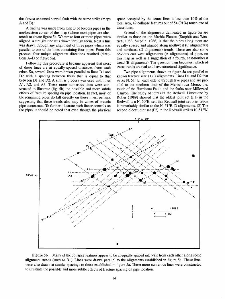
the closest unnamed normal fault with the same strike (maps A and B).-
A tracing was made from map B of breccia pipes in the northeastern corner of this map (where most pipes are clustered) to create figure Sa. Wherever four or more pipes were aligned, a straight line was drawn through them. Next a line was drawn through any alignment of three pipes which was parallel to one of the lines containing four pipes. From this process, four unique alignment directions resulted ( directions A-D on figure Sa).
Following this procedure it became apparent that most of these lines are at equally-spaced distances from each other. So, several lines were drawn parallel to lines D 1 and D2 with a spacing between them that is equal to that between D 1 and D2. A similar process was used with lines A1, A2, and A3. These more numerous lines were constructed to illustrate (fig. Sb) the possible and more subtle effects of fracture spacing on pipe location. In fact, most of the remaining pipes do fall directly on these lines, perhaps suggesting that these trends also may be zones of breccia pipe occurrence. To further illustrate such linear controls on the pipes it should be noted that even though the physical
A1----35°42'30"
space occupied by the actual lines is less than 10% of the total area, 49 collapse features out of 54 (91%) touch one of these lines.
Several of the alignments delineated in figure Sa are similar to those on the Marble Plateau (Sutphin and Wenrich, 1983; Sutphin, 1986) in that the pipes along them are equally spaced and aligned along northwest (C alignments) and northeast (D alignments) trends. There are also some obvious east-west alignments (A alignments) of pipes on this map as well as a suggestion of a fourth, east-northeast trend (B alignments). The question then becomes, which of these trends are real and have structural significance.
Two pipe alignments shown on figure Sa are parallel to known fracture sets: ( 1) D alignments. Lines D 1 and D2 that strike N. S1° E., each extend through five pipes and are parallel to the southern limb of the Meriwhitica Monocline, much of the Hurricane Fault, and the faults near Milkweed Canyon. ·The study of joints in the Red wall Limestone by Roller (1989) showed that the oldest joint set (Fl) in the Redwall is a N. 50°E. set; this Redwall joint-set orientation is remarkably similar to theN. 51 °E. D alignments. (2) The second oldest joint set (F2) in the Redwa11 strikes N. 51 °W.
113"27'30"
•
t 0 1 MILE N
I
• Figure Sb. Many of the collapse features appear to be at equally spaced intervals from each other along some
alignment trends (such as B 1). Lines were drawn parallel to the alignments established in figure Sa. These lines were also drawn at similar spacings to those established in figure Sa. These more numerous lines were constructed to illustrate the possible and more subtle effects of fracture spacing on pipe location.
14

(Roller 1989). Lines Cl, C2, and C3 (fig. 5a) strike N. 54°W. and go through four, five, and five pipes, respectively. Three other parallel-striking lines extend through nine additional pipes; these, along with lines Cl-C3, form alignments that have equal distance between them (fig. 5b).
Two other alignment directions appear on figure Sa: (1) A alignments. The alignment labelled "AI" strikes east-west, directly through five breccia pipes that are spaced roughly 1 ,SOO ft, or multiples of 1 ,SOO ft, apart; and (2) B alignments. Alignment "B 1" strikes N. 63° E. through six pipes tliat are spaced approximately 5,500 ft apart. Lines B2
and B3 intersect three pipes each, and trend parallel to B 1. These pipes are also equally spaced, or are spaced multiples of the equal spacing.
The series of lines drawn parallel to D 1 and D2, with a spacing equal to that between D 1 and D2, intersect lines B 1, A 1, and A2 at breccia-pipe localities (fig. Sb ). A similar scenario exists with the intersections of the various C lines. The geometry of the intersections of these alignments explains both the l,SOO ft equal spacing (or multiples of it) of pipes in the A-alignment set and the S,SOO ft equal spacing between pipes in the B-alignment set (figs. 5b and Sc).
N
l
• Pipes with an east-west alignment (set A on fig. Sa)
@ Pipes with a N62°E alignment (set B on fig. Sa)
Figure Sc. Schematic diagram illustrating that two nearly orthogonal joint sets (N. SSO W. and N. 5T E.) can create the appearance of more than two breccia-pipe alignment trends. Note: (1) the east-west trend similar to the A set in figure 5a, (2) the N. 62° E. trend similar to the B set in figure Sa, and (3) the north-south, N. 2S 0 E., N. 2S 0 W., etc. trends, which can be created here by placing more "pipes" at trend intersections, but are not developed in the map area (fig. Sa). Diagram is modified from Verbeek (written commun., 1988) and Roller (1989, fig. 22).
IS

Roller (1989) shows a fracture set that is almost east-west (A alignment) in the Redwall and younger strata, and Verbeek and others (1988) found a fracture set that has strikes of N. 60° E. 'tO N. 79° E. (B alignment); both sets were not active until after the Pennsylvanian and Permian strata were deposited-in fact, not until after the breccia pipes were formed and mineralized (therefore the east-west and N. 60-79° E. set are younger than 200 Ma and had no influence on breccia-pipe location). In contrast to these two orientations, the D alignment set of N. 51° E., which is the Fl direction in the Redwall Limestone of Roller (1989), is the orientation of many Laramide faults and monoclines (see map A), and a direction along which the Ridenour Mine and three other mineralized pipes are aligned (discussed in Wenrich and others, 1997). Likewise, the C alignment set of N. 50° W. follows the F2 direction in the Redwall Limestone of Roller (1989). If the C and D alignments of pipes appear to be related to Redwall fractures that controlled breccia-pipe locations, how did the A and B alignments form when no such fractures in the Redwall Limestone have been documented?
It is important to understand that the four distinct directions of breccia pipe alignments (A, B, C, and D) can be created by only two orthogonal (or nearly orthogonal) joint sets. Figure 5c shows a schematic diagram suggesting that when breccia pipes form at the intersections of N. 55° W.and N. 57° E.-trending fractures, as suggested by Sutphin and Wenrich ( 1983 ), multiple alignments of pipes, such as east-west and N. 62° E., can also appear. Thus, these east-west alignments on the southwestern Hualapai Reservation are real, as is the east-west alignment through Pinenut, Arizona 1, Lost Calf, Little Robinson, and June breccia pipes (located to the north of the map area on the Arizona Strip) discussed by Sutphin and Wenrich ( 1989). Also real is the regular spacing of these pipes. Nevertheless, these breccia-pipe locations need not be due to any "structural control" along an east-west strike. Instead they are due solely to N. 51_0 W. and N. 50° E. joint sets in the Redwall Limestone that were described by Roller (1989), and were derived in the manner described above and shown in figure 5c. In this report, such derived trends will be called "secondary alignments." Secondary alignments, particularly the N. 63° E.-striking B 1 alignment (fig. Sa), can exhibit equally spaced pipes when the fracture spacing is regular. Spacing of pipes is dependent on fracture spacing, and, if the fracture spacing becomes irregular, so will the spacing of the breccia pipes. Furthermore, if the fracture density is irregular in the northeast and northwest orthogonal directions, or the pipes form at random fracture intersections rather than routinely along specific northwest or northeast fractures, then recognition of alignments becomes difficult and breccia pipe locations appear random, as they do on much of the Hualapai Reservation.
What causes the fracture spacing and the breccia-pipe occurrences to become more regular in areas such as the Marble Plateau and the northeast part of this map area is still a mystery. It may be significant that both of these areas are near the intersection of large monoclines, which presumably are an indication of an underlying junction in basement blocks. Also, the monoclines on the Marble Plateau
16
(the Grandview, Coconino Point, and East Kaibab Monoclines) have orientations and shapes similar to those (the Horse Flat and Meriwhitica Monoclines) on the Hualapai Plateau (Wenrich and others, 1996). Both areas have apparently been repeatedly subjected, as discussed earlier through evidence of reactivation along faults such as the Hurricane, to more extension than other parts of northern Arizona with fewer faults and monoclines; such extension probably resulted in increased fracture density.
DISCUSSION
Most of the brecciation and mineralization of the pipes in this area predates the oldest of the folds and faults which deform the Paleozoic host rocks; that is, late PaleozoicTriassic pipe formation and mineralization predate Laramide and younger tectonism. The underlying Precambrian fault zones may have acted as structural hinges during the long Paleozoic through Cretaceous period of subsidence and sedimentation. Specifically, the pre-existing faults may not have produced sufficient displacement to appreciably deform the overlying Paleozoic and younger rocks, yet minor flexing along the Precambrian faults during Paleozoic time could have allowed for upward propagation of fractures into the overlying section. This would have increased fracture densities in the brittle carbonate rocks (such as the Redwall) along the strikes of the underlying fault zones. Such a scenario may have been observed by Roller (1989) who found anomalously closely spaced early-formed fractures in the Redwall Limestone adjacent to four breccia pipes. Localized dissolution of the carbonates aided by joint-enhanced permeability would then have created ideal sites for the nucleation of future pipes.
The entire process of pipe localization also predates even the Laramide monoclines. Consequently the presence of pipe alignments along Laramide and post-Laramide structures simply serves notice that the Precambrian faults underlying and controlling those younger structures aided the upward propagation of fractures important for pipe formation. Such fracturing took place long before the basement faults were reactivated to such an extent that the overlying sedimentary rocks failed through faulting or folding.
DESCRIPTION OF MAP UNITS
SURFICIAL AND VOLCANIC DEPOSITS
Oat Alluvial deposits (Holocene)-Unconsolidated fluvial deposits of silt, sand, and boulders; includes flood-plain deposits. Faults shown bounding alluvium do not offset alluvium, instead, alluvium is banked against exhumed fault scarps
Oc Colluvium (Holocene and Pleistocene?)-Con-sists of brecciated rock fragments, boulders, gravel, sand, and silt; partially consolidated with a gypsiferous or calcareous cement.

Ot
QTI
OTg
Ti
Tv
Tc
Tg
Includes alluvial-fan and landslide debris. Locally includes reworked Cenozoic gravel on Hualapai Plateau. Faults shown bounding colluvium do not offset colluvium
Travertine deposits (Holocene and Pleistocene)-Spring deposits of calcium carbonate. Includes angular boulders, gravel, sand, and silt derived from adjacent talus deposits
Landslides (Holocene, Pleistocene, and Pliocene?)-Unsorted and unconsolidated material; consists mainly of large blocks of Paleozoic sedimentary rock that have slid downward and rotated towards the base of the parent wall
Younger gravel, undivided (middle Miocene to Pliocene)-Reworked conglomerate, sand, gravel, and silt from older gravel deposits and volcanic units; also consists of locally derived Paleozoic clasts mixed and reworked with some Precambrian quartzite and volcanic (Miocene) clasts. Includes the Coyote Spring Formation of Young (see Appendix, this pamphlet). Clasts are matrix supported and cemented with calcium carbonate. Commonly covered by thin colluvium and caliche. Thickness ranges from 20 to 200ft
Intrusive volcanic rocks (early to middle Miocene)-Alkali-olivine basalt and andesitic basalt dikes and plugs
Volcanic deposits undivided (early to middle Miocene)-Volcanic deposits on the Hualapai Plateau; includes the Poeach Spring Tuff of Young (see Appendix, this pamphlet), basalt flows, agglomerate, and volcanogenic fluvial sediments. The Peach Spring Tuff is a gray welded rhyolitic ash-flow tuff that is thin-bedded; locally the tuff includes volcanic pebbles of various lithology. Dated at 18.3±0.6 Ma (Damon, 1966, p. 28; Valentine and others, 1989). Thickness averages about 30ft
Basaltic cinder deposits (early to middle Miocene)-Basaltic, coarse-grained pyroclastic deposits near vent areas. Sometimes gradational with the Buck and Doe Conglomerate (Young, 1966); some cinder deposits derived from an unknown source to the west. Thickness unknown
Undifferentiated gravel deposits (Pliocene to Late Cretaceous)-Mostly conglomerate, breccia, and faglomerate, with some gravel, sand, silt, and limestone. Fills older canyons and valleys on the Hualapai Plateau.
Tp
IPmw
Ms
17
Includes, undivided, Coyote Spring Formation, Buck and Doe Conglomerate, Hindu Fanglomerate, West Water Formation, Music Mountain Formation and Robbers Roost gravel as described by Young (see Appendix, this pamphlet). Poor exposures make it difficult to distinguish the correct stratigraphic sequence in areas of low relief. Thickness 10-700 ft. Thickest deposits in Milkweed, Hindu, Lost Man, and Peach Springs Canyons
Coarsely crystalline intrusive plutonic stock (Paleocene )-Coarsely crystalline· quartzfeldspar-hornblende-biotite-bearing pluton that intrudes Cambrian rocks on the Grand Wash Cliffs, northwest corner of map. Mapped by Young (1966) and dated at 65.5 Ma by E.H. McKee (Young, 1979, p. 44). Unconformably overlain by Tv
SEDIMENTARY ROCKS
Lower part of Supai Group: Manakacha and Watahomigi Formations undivided (Middle and Lower Pennsylvanian)
Manakacha Formation (Middle Pennsylvanian)-Reddish-brown, fine-grained, thickbedded sandstone and shale interbedded with gray, medium-grained, crossbedded dolomite and thin-bedded limestone; contains a few thin, red-brown shales. Mostly removed by Cenozoic erosion. Forms a sequence of slopes and ledges. Maximum thickness about 150 ft
Watahomigi Formation (Middle and Lower Pennsylvanian)-Purple-gray to gray, slope-forming, calcareous siltstone and finegrained sandstone, interbedded with gray, ledge-forming, thin- to medium-bedded limestone containing red chert lenses. Includes a few thin-bedded conglomerate and limestone units near the base. A thickbedded, gray, fossiliferous limestone ledge in the lower slope thickens westward and forms a small cliff. Average thickness is 180ft
Surprise Canyon Formation (Upper Mississippian)-Consists of a basal ledge of chert pebble conglomerate, clast -supported, that has a dark red-brown to black iron-stained sandy matrix; a middle cliff-forming, yellowish-gray, coarsely crystalline, silty, crumbly, thin-bedded, fossiliferous limestone; and an upper slope- and ledge-forming, dark-red- brown, thin-bedded, fine-grained siltstone and sandstone that

Mr
Dtb
£m
£ba
contains laminated beds of silty limestone; deposited within paleo-caves and paleo-val-leys eroded into the Redwall Limestone. Thickness ranges from a few ft to 75 ft; £t mostly removed by Cenozoic erosion in the
Tapeats Sandstone is arbitrarily placed at or near top of Tapeats Sandstone cliff. Forms slope; unit nearly 350 ft thick
Tapeats Sandstone (Lower Cambrian)Light-gray to light-brown, red-purple, medium- to coarse-grained, medium-bedded sandstone to quartzite, and small-pebble conglomerate. Has abundant low-angle crossbedding and thin, green shale partings between beds in upper part; forms cliff; ranges in thickness from 50 to 200 ft
map area Redwall Limestone (Upper and Lower Missis
sippian)-From top to bottom, includes the Horseshoe Mesa, Mooney Falls, Thunder Springs, and Whitmore Wash Members, undivided. Red wall forms a sheer cliff with a slight recess at the contact between the Horseshoe Mesa and Mooney Falls Members. All four members consist of a light-gray, thick-bedded, aphanitic limestone and dolostone that contains marine fossils throughout. White chert bands are common in the Thunder Springs Member. Thickness ranges to as much as about 650 ft; mostly removed by Cenozoic erosion in the map area
Temple Butte Formation (Upper and Middle? Devonian)-Dark-gray to purple-gray, medium-bedded dolostone, dolomitic sand-stone, and sandy limestone; interbedded with reddish-brown siltstone and gray siltstone. Forms a series of ledges; averages 400 ft thick; mostly removed by Cenozoic erosion
Tonto Group (Middle and Lower Cambrian) Muav Limestone (Middle Cambrian)-Mot
tled gray and purple, thin-bedded, dolomitic limestone that weathers rusty gray. Upper 450 ft includes a white to light-gray sequence of dolostones between Temple Butte Formation and Muav L:-imestone. Limestone ledges and small cliffs are sepa-rated by tongues of slope-forming green shale lithologically similar to underlying Bright Angel Shale. Lower contact with the Bright Angel Shale is at the base of the Ram-part Cave Member of the Muav Limestone (McKee and Resser, 1945). Averages 600-750 ft thick; mostly eroded by Cenozoic erosion
Bright Angel Shale (Middle Cambrian)Green and purplish-red, fissile siltstone; interbedded with rusty-brown and dark-gray dolostone tongues of the Muav Limestone in upper part; interbedded with· light-brown to reddish-brown, coarse-grained, thin-bedded sandstone beds of Tapeats lithology in lower part. A very coarse grained, purple-red sandstone (red-brown member of McKee and Resser, 1945) forms a cliff at about the middle of the unit. Lower contact with the
18
IGNEOUS AND METAMORPHIC ROCKS
Vishnu Group (Early Proterozoic) (Upper amphibolite facies)
Xgr Nonfoliated granitic plutons-Brown to light-red, holocrystalline, quartz-bearing granite plutons
Xg rf Foliated granitic plutons-Light-colored, coarse-grained, plutonic granite that contains feldspar and mafic minerals
Xvs Mica schist-Composed of mica and quartz; well-marked schistose foliation; mica is mainly muscovite and biotite
Xva Mafic schist and amphibolite-Very fine grained, foliated, contains dark-colored minerals; also contains amphibole and plagioclase and little or no quartz
Xvm Paragneiss-Granular feldspar and quartz parted by lenticular layers and fine-grained amphibole minerals
Xu Precambrian rocks, undivided-Brown to reddish-brown, holocrystalline, quartzbearing granite plutons; contains foliated schist and gneiss, and quartz-feldspar peg-matites
ACKNOWLEDGMENTS
The authors are indebted to Bradley S. Van Gosen for the care with which he compiled and plotted the brecciapipe data. Hoyt B. Sutphin provided mapping assistance in the early stages of this project. His continued assistance, enthusiasm, and exchange of ideas have helped to make this project a success. L. Sue Beard, Anthony Gibbon, Craig Bronstein provided reviews. I thank Denny Welp and Alice and Joe Springfield for color and layout design and map and pamphlet layout. Also a special thanks to Mike Bertoldi, Dana Morris, and Tim Wilkerson of Grand Canyon Helicopters for safely and competently transporting us in hazardous flying conditions to various locations in the study area. This project was funded by the U.S. Bureau of Indian Affairs in cooperation with the Hualapai Tribe. A special thanks goes to the Hualapai Tribe for their continued support of this

research and for permission to publish the Western Nuclear Inc. drilling data.
REFERENCES CITED
Beard, L.S., 1985, Precambrian geology of the Cottonwood Cliffs area, Mohave County, Arizona: Tucson, University of Arizona, M.S. thesis, 115 p., one map, scale 1:15,000.
Billingsley, G.H., and Huntoon, P.W., 1983, Geologic map of the Vulcan's Throne and vicinity, western Grand Canyon, Arizona: Grand Canyon Natural History Association, Grand Canyon, Arizona, scale 1:48,000.
Billingsley, G.H., Wenrich, K.J., and Huntoon, P.W., 1986, Breccia pipe and geologic map of the southeastern Hualapai Indian Reservation and vicinity, Arizona: U.S. Geological Survey Open-File Report 8~58-B, 26 p., 2 plates, scale 1:48,000.
---in press, Breccia-pipe and geologic map of the southeastern part of the Hualapai Indian Reservation and vicinity, northwestern Arizona: U.S. Geological Survey Miscellaneous Investigations Series Map 1-2643, 2 sheets, scale 1 :48,000. ·
Chenoweth, W.L., 1986, The Orphan Lode mine, Grand Canyon, Arizona, a case history of a mineralized, collapse-breccia pipe: U.S. Geological Survey Open-File Report 86-510, 126 p.
Clark, M.D., 1976, The geology and petrochemistry of the Precambrian metamorphic rocks of the Grand Canyon, Arizona: England, University of Leicester, Ph.D. Thesis, 216 p.
Damon, P.E., 1966, Correlation and chronology of ore deposits and volcanic rocks, Annual Progress Report No. C00-689-60 [Contract AT(11-1)-689] to Research Division, U.S. Atomic Energy Commission: Tucson, Ariz., Geochrono~ogy Laboratories, University of Arizona, 46 p.
Gray, R.S., 1959, Cenozoic geology of Hindu Canyon, Mohave County, Arizona: Tucson, University of Arizona, M.S. thesis, 64 p.
Huntoon, P.W., 1981, Grand Canyon monoclines, vertical uplift or horizontal compression?: Contributions to Geology, v. 19, p. 127-134.
---1989, Phanerozoic tectonism, Grand Canyon, Arizona, in Elston, D.P., Billingsley, G.H., and Young, R.A., eds., Geology of Grand Canyon, northern Arizona (with Colorado River Guides): 28th International Geological Congress Field trip guidebook T115/315, American Geophysical Union, Washington D.C. p. 76-89.
Huntoon, P.W., Billingsley, G.H., and Clark, M.D., 1981, Geologic map of the Hurricane Fault Zone and vicinity, western Grand Canyon, Arizona: Grand Canyon
19
Natural History Association, Grand Canyon, Arizona, scale 1:48,000.
Huntoon, P.W., Billingsley, G.H., and Clark, M.D., 1982, Geologic map of the Lower Granite Gorge and vicinity, western Grand Canyon, Arizona: Grand Canyon Natural History Association, Grand Canyon, Arizona, scale 1:48,000.
Koons, D., 1948, Geology of the eastern Hualapai Reservation: Museum of Northern Arizona Bulletin (Plateau), v.20,no.4,p.53-60.
---1964, Structure of the eastern Hualapai Indian Reservation, Arizona: Arizona Geological Society Digest, v. 7, p. 97-114.
Lucchitta, Ivo, 1979, Late Cenozoic uplift of the southwestern Colorado Plateau and adjacent lower Colorado River region: Tectonophysics, v. 61, p. 63-95.
Mathisen, I.W., Jr., 1987, Arizona Strip breccia pipe program: Exploration, development, and production [abs.]: American Association of Petroleum Geologists Bulletin, v. 7115, p. 590.
McKee, E.D., and Resser, C.E., 1945, Cambrian history of the Grand Canyon region: Washington, D.C., Carnegie Institute Publication 563, 232 p.
Naeser, C.W., Duddy, I.R., Elston, D.P., Dumitru, T.A., and Green, P.F., 1989, Fission-track dating: Ages for Cambrian strata, and Laramide and post-middle Eocene cooling events from the Grand Canyon, Arizona; in Field trip Guidebook T115/315, 28th International Geological Congress: Washington, D.C., American Geophysical Union, p. 166-173.
Nielson, J.E., Lox, D.R., Dalrymple, G.B., and Glazner, A.F., 1990, Age of the Peach Springs Tuff: Journal of Geophysical Research, v. 95, p. 571-580.
Pierce, H. W., 1984, The Mogollon Escarpment: Arizona Bureau of Geology and Mineral Technology Fieldnotes, v. 14, no. 2, p. 8-11.
Roller, J.A., 1987, Fracture history of the Redwall Limestone and lower Supai Group, western Hualapai Indian Reservation, northwestern Arizona: U.S. Geological Survey Open-File Report 87-0359, 33 p.
---1989, Fracture history of the Redwall Limestone, lower Supai Group, and Tertiary units on the Hualapai Indian Reservation, northwestern Arizona-Additional data to Open-File Report 87-359: U.S. Geological Survey Open-File Report 89-463, 42 p.
Sutphin, H.B., 1986, Occurrence and structural control of collapse features on the southern Marble Plateau, Coconino County, Arizona: Flagstaff, Northern Arizona University, M.S. thesis, 139 p.
Sutphin, H.B., and Wenrich, K.J., 1983, Structural control of breccia pipes on the southern Marble Plateau, Arizona: U.S. Geological Survey Open-File Report 83-908, 6 p., 2 plates, scale 1:50,000. [Superseded by Sutphin, H.B., and Wenrich, K.J., 1988, Map showing structural control of breccia pipes on the southern

Marble Plateau, north-central Arizona: U.S. Geological Survey Miscellaneous Investigations Series Map I-1778, 2 plates, scale 1:50,000.]
---1989, Map of locations of collapse-breccia pipes in the Grand Canyon region of Arizona: U.S. Geological Survey Open-File Report 89-550, 1 plate, scale 1:250,000.
Twenter, F.R., 1962, Geology and promising areas for groundwater development in the Hualapai Indian Reservation, Arizona: U.S. Geological Survey Water-Supply Paper 1576-A, p. 1-38.
Van Gosen, B.S., and Wenrich, K.J., 1989, Ground magnetometer surveys over known and suspected breccia pipes on the Coconino Plateau, northwestern Arizona: U.S. Geological Survey Bulletin 1683-C, p. 1-31.
Valentine, G.A., Buesch, D.C., and Fisher, R.V., 1989, Basal layered deposits of the Peach Springs Tuff, northwest Arizona, USA: Bulletin ofVolcanology 51, p. 395-414.
Verbeek, E.R., Grout, M.A., and Van Gosen, B.S., 1988, Structural evolution of a Grand Canyon breccia pipe-The Ridenour copper-vanadium-uranium mine, Hualapai Indian Reservation, Coconino County, Arizona: U.S. Geological Survey Open-File Report 88-006, 75 p.
Walcott, C.D., 1890, Study of a line of displacement in the Grand Canyon of the Colorado in northern Arizona: Geological Society of America Bulletin, v. 1, p. 49-64.
Wenrich, K.J., 1985, Mineralization of breccia pipes in northern Arizona: Economic Geology, v. 80, no. 6, p. 1722-1735.
---1986, Geochemical exploration for mineralized breccia pipes in northern Arizona, U.S.A.: Applied Geochemistry, v. 1, no. 4, p. 469-485.
---in press, Geochemistry and mineralogy of the Surprise Canyon Formation-its significance in the location of Grand Canyon ore deposits, in Billingsley, G.H., ed., Surprise Canyon Formation: U.S. Geological Survey Professional Paper, 22 ms p.
Wenrich, K.J., Billingsley, G.H., and Huntoon, P.W., 1996, Breccia-pipe and geologic map of the northwestern part of the Hualapai Indian Reservation and vicinity, northwestern Arizona: U.S. Geological Survey Miscellaneous Investigations Map I-2522, 57 p., 2 plates, scale 1:48,000.
---1997, Breccia pipe and geologic map of the northeastern part of the Hualapai Indian Reservation and vicinity, northwestern Arizona: U.S. Geological Survey
20
Miscellaneous Investigations Map I-2440, 60 p., 2 plates, scale 1:48,000.
Wenrich, K.J., Billingsley, G.H., and Van Gosen, B.S., 1986, The potential for breccia pipes in the National Tank area, Hualapai Indian Reservation, Arizona: U.S. Geological Survey Open-File Report 86-592-A, 45 p.
Wenrich, K.J., and Sutphin, H.B., 1989, Lithotectonic setting necessary for formation of a uranium rich, solution collapse breccia pipe province, Grand Canyon region, Arizona, in Metallogenesis of uranium deposits: Vienna, International Atomic Energy Agency Technical Committee Meeting, 9-12 March, 1987, IAEA-TC-542/20, p. 307-344 (Also released as U.S. Geological Survey Open-File Report 89-173, 33 p.).
Wheeler, R.L., 1986, Selecting reliable alignments of mapped points: Structural control of breccia pipes on the Marble Plateau, northern Arizona: Geological Society of America Abstracts with Programs, v 18, no. 5, p. 422.
Young, R.A., 1966, Cenozoic geology along the edge of the Colorado Plateau in northwestern Arizona: Washington University Ph.D. dissertation, 167 p.
---1979, Laramide deformation, erosion and plutonism along the southwestern margin of the Colorado Plateau: Tectonophysics, v. 61, nos. 1-3, p. 25-47.
---1982, Paleogeomorphic evidence for the structural history of the Colorado Plateau margin in western Arizona, in Frost, E.G., and D.L. Martin, eds., Mesozoic-Cenozoic tectonic evolution of the Colorado River region, California, Arizona, and Nevada: Cordilleran Publishers, San Diego, California, p. 29-39.
---1987, Landscape development during the Tertiary, in Colorado Plateau, in Graf, W.L., ed., Geomorphic systems of North America: Geological Society of America Centennial volume 2, p. 265-276.
---1989, Paleogene-Neogene deposits of western Grand Canyon, Arizona, in Elston, D.P., Billingsley, G.H, and Young, R.A., eds., Geology of Grand Canyon, northern Arizona; Fieldtrip Guidebook T115/315, 28th International Geological Congress: Washington, D.C., American Geophysical Union, p. 166-173.
Young, R.A., and Brennan, W.J., 1974, Peach Springs tuff, its bearing on structural evolution of the Colorado Plateau and development of Cenozoic drainage in Mohave County, Arizona: Geological Society of America Bulletin, v. 85, p. 83-90.

APPENDIX
NOMENCLATURE AND AGES OF LATE CRETACEOUS(?)-TERTIARY STRATA IN THE HUALAPAI PLATEAU REGION,
NORTHWEST ARIZONA
By
Richard A. Young1
1State University of New York at Geneseo, Geneseo, New York


APPENDIX CONTENTS Abstract 25 Introduction 25
Early Studies 25 Regional and Local Correlation Problems 25 Cretaceous to Eocene Rocks in Southern Utah and Eastern Arizona 28
Stratigraphy of the Hualapai Plateau: Previous Work 28 Music Mountain Formation 28
Background 28 Nomenclature of Koons, Eastern Hualapai Plateau 28 Nomenclature of Gray, Western Hualapai Plateau 29
1 )Mislocation of Sections 29 2)Hindu Canyon Formation 30 3)Buck and Doe Conglomerate of Gray (1964) 30 4 )Geologic Interpretations 31 5)Additional Concerns 31
Redefinition of Geologic Names 31 Revised Stratigraphy of Laramide-age Rocks 32
Music Mountain Formation 32 Environmental Interpretation 34
West Water Formation 35 Evidence for Age of Music Mountain and West Water Formations 36
Distribution and Regional Correlations 36 Regional Orogenic Events 36 Fission Track Uplift Data 37 Related Stratigraphic Sections: Coconino Plateau 37 Paleontology: Long Point Limestone Beds 38 Significance of Late Cretaceous-early Paleocene(?) Volcanism 38 Paleomagnetic Age Constraints 39 Summary of Age Data 39
Younger Lag Deposits Derived from Music Mountain Formation 39 Potential Confusion with other Gravel Types 40 Hindu Fanglomerate 40
Revised Stratigraphy: Post-Laramide-age Sediments 40 Buck and Doe Conglomerate 40
Variations across the Hualapai Plateau 41 Environment of Deposition 41
Miocene Volcanic Rocks 42 Peach Spring Tuff (Peach Springs Tuff ofYoung and Brennan, 1974) 43 Nomenclature Issues 43 Proposed Formal Name Change: Peach Spring Tuff 44 Type Locality 44 Relevance to Age of Music Mountain Formation 44
Coyote Spring Formation 45 Environment of Deposition and Age 45
Summary 45 Measured Stratigraphic Sections and Type Localities, Hualapai Plateau Cretaceous(?)
and Tertiary Rocks 46 Music Mountain Formation 46 West Water Formation 46 Hindu Fanglomerate 47 Milkweed Canton Section 47 Coyote Spring Formation 48
References 48

APPENDIX CONTENTS FIGURES
1 Hualapai Plateau and adjacent region. 26 2 Geographic map of major features on the southwestern part of the Hualapai Plateau. 27 3 Illustration of diagrammatic field relations of defined Tertiary rock units and equivalent map unit symbols
used on accompanying geologic map, I-2554. 34
TABLES
Existing informal names and proposed names of recognized Cretaceous(?)-Tertiary geologic units, Hualapai Plateau. 32
2 Age estimates and absolute age constraints for Cretaceous(?) and Tertiary rocks on the Hualapai Plateau. 33

ABSTRACT
The Hualapai Plateau in the western Grand Canyon region of northern Arizona contains one of the most complete and diverse Late Cretaceous(?) to Pliocene stratigraphic sections on the Colorado Plateau. The terrestrial sediments and volcanic rocks also partially fill and preserve a pre-Colorado River paleocanyon system of probable Late Cretaceous to Paleocene age. The Tertiary sections east and west of the Hurricane fault include eight distinct rock units that either have not been described using adequately designated type sections in the formal geologic literature, or whose published descriptions include incomplete, incorrect, or contradictory information. This compilation traces the evolution of the inadequate nomenclature in the geologic literature and proposes formal stratigraphic names to correct errors and inconsistencies. Wherever possible, names that have priority are retained or redefined.
Type sections or principal reference sections are designated for all but one of the Cretaceous(?)-Tertiary units appearing on the detailed maps of the Hualapai Indian Reservation by Young (1966), Wenrich and others (1986), Billingsley and others (1986), and this report. The Robbers Roost gravel (Koons, 1948a) at the base of the Cretaceous(?)-Tertiary sequence is retained as an informal name in order to complete the regional stratigraphy. However, th~ Robbers Roost gravel does not crop out in the area covered by the map accompanying this report (I-2554 ), and no locality that exposes both the upper and lower contacts of the Robbers Roost gravel has been studied in detail by the writer.
Map symbols for some Tertiary units on the published maps of the Hualapai Indian Reservation combine two or more of the formations described in this paper (table 1). This compromise is necessitated by the 1:48,000 scale used for the maps, by the small outcrop areas of individual Tertiary units in some localities, or by the poor quality of exposures in areas of low relief.
INTRODUCTION
EARLY STUDIES
Geologic reconnaissance studies of parts of the Hualapai Plateau region (as defined by Darton, 1925) were conducted by Marvine (1875), Lee (1908), Darton (1925), Davis, (1930), Blissenbach (1952), Koons (1948a, b), Gray (1959, 1964), and Twenter (1962). Collectively, these geologists recognized the presence of erosion surfaces and large paleocanyons that are filled with, and covered by, an assortment of Cretaceous(?)-Tertiary fluvial and volcanic sediments, which are older than the modern Colorado River (figs. 1 and 2). Only Gray (1964) and Koons (1948a, b; 1964) applied specific names to some of the Tertiary gravel units they described prior to the work ofYoung (1966).
Few of the early reports document either the antiquity or the diversity of the deposits within paleovalleys that contain sequences of fluvial, volcanic, and lacustrine sediments exceeding 1,200 vertical ft (366m) as described by Young
25
(1966). Workers prior to Young (1966) did not describe the existence of a significant disconformity marked by a thick weathering profile within the basal Cretaceous(?)-Tertiary sections. The reconnaissance studies by several geologists have resulted in stratigraphic nomenclature problems that include: (1) the usage of inadequate and misleading informal names, (2) improperly defined formation boundaries (Gray, 1964), (3) incorrect age assignments (Gray, 1964), (4) duplicate names for the same unit (Koons, 1948a, b), (5) incorrect correlations (Gray, 1964), and (6) inadequate or mislocated type localities for published descriptions of Ter-tiary units (Gray, 1964). '
Young attempted to resolve many of the discrepancies by mapping and defining nine distinct facies or formations that can be recognized discontinuously across the Hualapai Plateau (Young, 1966; Young and Brennan, 1974), and in adjacent areas (Young and others, 1987; Young, 1989). Recognition of the unique character and widespread distribution of an early Miocene ash flow, informally named the Peach Springs tuff (Young, 1966; Young and Brennan, 1974), permitted the establishment of a basic stratigraphic framework between key local sections, improved regional correlations, and pointed to a pre-Miocene, possible Laramide, age for the oldest units and associated paleogeography. Published descriptions of the Peach Springs tuff by Young (1966), by Young and Brennan (1974), and by later workers (Buesch and Valentine, 1986) failed to designate a formal type locality for the unit, despite its widespread importance as a regional stratigraphic marker (Glazner and others, 1986).
This paper summarizes the origins of the stratigraphic nomenclature currently in informal usage for Cretaceous(?) to Pliocene rock units on the Hualapai Plateau (table 1), documents the inadequacies of informal names already in use, designates formal type localities, and establishes revised formal names to eliminate the current inadequacies.
REGIONAL AND LOCAL CORRELATION PROBLEMS
The solution to the major stratigraphic correlation problem depends upon the acceptance of a Late Cretaceous(?) to Eocene (Laramide) age for the oldest arkosic sediments all around the western and southern edges of the Colorado Plateau. Limited regional correlations on and around the Hualapai Plateau are based on age data from the oldest interbedded fluvial and lacustrine sediments, which in many other places rest disconformably on the Kaibab or Moenkopi Formation. The arkosic sediments unconformably underlie Oligocene to Miocene volcanic rocks and associated gravel scattered across a broad region of northern Arizona. A few fossils and isolated volcanic ash beds (Potochnik, 1989) have provided a limited regional chronology whose extrapolation from northern and central Arizona into southern Utah depends on acceptance of a Laramide tectonic framework to link the widely scattered depositional sequences, which appear to have formed under relatively humid climatic conditions.
The clast rock types of all the Cretaceous(?) to Tertiary gravel and conglomerate units on and near the Hualapai

'
,. 'i
on.oJ..... '/ "'-Cataract
Ck. COCONINO
tc ~ O/ol'ct ~0
PLATEAU ~~
'--
3~-
• Wickenburg
-Basalt
-----· Fault
100 Km
• I
Figure Al. Hualapai Plateau and adjacent region. Filled arrows indicate Late Cretaceous(?)-Paleogene drainage directions. Open arrows indicate possible speculative continuation of equivalent drainage north of modern Grand Canyon.
Plateau exhibit systematic areal and vertical variations, a condition that complicates simple correlation between sections. Within the lowermost Tertiary gravel units these lithologic differences largely reflect the progressive
26
erosional unroofing of Paleozoic and Precambrian rocks cropping out in drainage basins that headed west and south of the present Colorado Plateau margin. Additional local lithologic differences among younger Tertiary gravel and

N -.]
113° 2 2'30" 113° 5 2'30'' To Bat Tower Viewpoint 24 miles
35°45' : ) :w to • • " : = s • • cc:. = · · ' To Colorado
35°37'3d'
~ !-..'0
~~ G:JI(;
~~
HUALAPAI
Jf>B ~6 ,.,
o~. "o/1
HUALAPAI
PLATEAU
To Kingman 38miles
!5 0 !5 mile•
Figure A2. Geographic map of the major features of the southwestern part of the Hualapai Plateau.
River 3miles
~To Seligman 30 miles
/

conglomerate reflect the diversity of local Paleozoic rock outcrops on the Colorado Plateau proper in the vicinities of the different paleochannels (fig. AI).
Reworking of the basal arkosic fluvial sediments has produced several generations of younger lag gravel dominated by those exotic clast rock types that are most resistant to weathering. Such reworked gravel is readily distinguished from weathered "parent" sediments by the high percentage of resistant quartzite clasts in the younger units and the absence of a highly weathered feldspathic matrix, which is -characteristic of the older sediments shed onto the Colorado Plateau.
Imprecise correlation of similar arkosic sediments and reworked lag gravel across northern and central Arizona has resulted in both the older parent deposits and some of their younger reworked derivatives being included in an informal category of Arizona "Rim gravels" mentioned in much of the previous literature on Arizona geology (Price, 1950; Cooley and Davidson, 1963). Careful field observations can distinguish true "Laramide" sediments from younger generations of reworked gravel, especially where the younger units incorporate clasts from local Oligocene or Miocene volcanic rocks.
CRETACEOUS TO EOCENE ROCKS IN SOUTHERN UTAH AND EASTERN ARIZONA
Late Cretaceous to Eocene terrestrial sequences that exhibit tectonostratigraphic relationships similar to those on the Hualapai Plateau are better dated along the edge of the Colorado Plateau in southern Utah (Goldstrand, 1990, I992, 1994). The Late Cretaceous to Eocene ages of these similar Utah deposits provide indirect support for the proposed Laramide origin for the oldest terrestrial sediments on the Hualapai Plateau. Regionally, the Hualapai Plateau sediments and their apparent correlatives rest on the erosion surface that bevels the Cambrian through Cretaceous rock section of northern and central Arizona (Reynolds, I988; Young and others, 1989; Young, 1987, 1993; Potochnik, 1989). -
In eastern Arizona, Potochnik (1989) bracketed the age of part of his Mogollon Rim Formation between 57 Ma and 37 Ma (Eocene) in an area along the Mogollon Rim near Fort Apache (fig. AI). The limited regional age constraints and the chronologie data in this paper are assumed to provide reasonable evidence for the existence of a widespread, lengthy, Laramide episode of uplift, erosion, and deposition extending at least from Late Cretaceous through middle Eocene time. Overall, the gradual upward changes in the local and regional Tertiary sections record (I) widespread Laramide uplift, erosion, and volcanism, accompanied by arkosic gravel deposition, (2) early to middle Miocene Basin and Range volcanism and tectonism, (3) a gradual change during middle or late Miocene time to the accumulation of sediments from nearby source rocks in local basins of deposition prior to Colorado River erosion, and ( 4) localized basaltic volcanism beginning in late Miocene time.
28
STRATIGRAPHY OF THE HUALAPAI PLATEAU: PREVIOUS WORK
MUSIC MOUNTAIN FORMATION
BACKGROUND
Koons (1948a, b; I964) described gravel deposits on the Hualapai Plateau east of the Hurricane Fault that previously had been mentioned by Darton (1925, p. I77), and which are included in the general category of widespread Arizona "Rim gravels" of Cooley and Davidson (I963). These fluvial deposits are generally accepted as a byproduct of the Late Cretaceous uplift of central Arizona, resulting in the spreading of fluvial sediments onto the eroded margin of the modem Colorado Plateau (Cooley and Davidson, I963; Potochnik, I989). Similar deposits on the Hualapai Plateau in Hindu Canyon (also mentioned by Darton, I925) were studied by Gray (1959, I964), who designated the oldest sediments in that canyon as the Hindu Canyon Formation (Gray I964). He stressed that the age relationships between similar deposits elsewhere on the Hualapai Plateau were not known, and thus the Tertiary stratigraphic units were not amenable to precise correlation. Unfortunately the proposed geologic names suggested by Koons (I948a) and by Gray (1964) are either incomplete or do not conform to the recommendations in the North American Stratigraphic Code (American Association of Petroleum Geologists, 1983). The names are further complicated by apparent errors and inconsistencies in the published descriptions.
NOMENCLATURE OF KOONS, EASTERN HUALAPAI PLATEAU
Koons (1948a, b) did not propose formal type sections, and subsequent mapping has demonstrated that there is no complete exposure of all the contacts within the sequence of gravel types he described east of the Hurricane Fault on the Hualapai Indian Reservation. The field relations between apparently similar rock units are better exposed beneath volcanic rocks on the adjacent Coconino Plateau (fig. AI), several miles to the east of Koons' original localities (Young, 1982; unpub. data, I995; Squires and Abrams, I975). Based on fieldwork in I946, Koons published two articles (Koons, I948a, b) in which he described two different gravel units, the older one locally derived, the other containing exotic igneous and metamorphic clasts. Koons named his oldest gravel unit, which is dominated by clasts of Paleozoic rocks, the Robbers Roost gravel, but published two different names for the younger unit, which is dominated by the igneous and metamorphic clasts derived from far to the south of the modem edge of the Colorado Plateau. Koons (I948a) first used the name, Blue Mountain gravel, for the younger, exotic unit. He noted that the gravel extended from Blue Mountain northward to Thornton Lookout on the eastern Hualapai Reservation, a distance of 32 km. However, in Koons (I948b), published a month later, the same gravel unit is referred to as the Frazier Well gravel

(spelled "Frazier's Well" on U.S. Bureau of Indian Affairs maps, but "Frazier Wells" on current U.S. Geological Survey topographic maps), named for a locality that is on the road between Blue Mountain and Thornton Lookout and within the outcrop area of the previously designated "Blue Mountain gravel." Only one gravel type. dominated by exotic clasts is present in this area, and no explanation is given for this obvious discrepancy.
Koons (1964) later described three gravel units in a report on reconnaissance fieldwork completed in 1949. He retained the terms Robbers Roost gravel and Frazier Well gravel, but added a "Cataract Creek gravel," described as "reworked Frazier Well gravel" (Koons, 1964). The article notes: "large deposits of Frazier Well gravel are found near Blue Mountain, surrounding Frazier Well and northward from Rose Well." The Cataract Creek gravel was said to be near and north of Rose Well and in Cataract Creek, which is several miles east of the Hualapai Reservation boundary on the Coconino Plateau (fig. Al). Koons, in McKee and others ( 1967), subsequently described the Robbers Roost deposits as "time transgressive" and possibly both older and younger than the "Blue Mountain Gravel." The confusion in name designations and overlapping of definitions in these several publications indicates that continued usage of these terms would require complete revision of the original definitions, establishment of adequate type localities, and descriptions of the specific differences between the units. Koons' data is limited to six published pebble counts, which were completed only for "Frazier Well gravel" and identified only on inadequate, small scale reconnaissance maps (Koons, 1964). Young (1966, 1993, and unpub. data, 1995) has completed multiple clast counts on all of the units described by Koons, as well as representative pebble counts on gravel units in many other previously described Tertiary(?) gravel localities in northern Arizona and in southern Utah. These additional.clast counts demonstrate both vertical and areal variations within broadly equivalent gravel units that occur across m\lch of the Colorado Plateau. The areal differences among gravel exposures are attributable to source region variations and the progressive exposure of uplifted basement rocks as the Paleozoic cover to the south was eroded away.
On the eastern Hualapai Plateau and the Coconino Plateau the basal arkosic sediments are underlain locally by Paleozoic-clast-bearing conglomerate units similar to the Robber's Roost gravel of Koons. These basal, typically well-cemented, conglomerate units represent the stripping of the Paleozoic cover rocks from the Colorado Plateau during the initial phases of Laramide(?) uplift of the Plateau margin before Precambrian sources were widely exposed nearer the heads of the north-flowing drainages. Such early deposits are not preserved in all stratigraphic sections; they appear more abundant and are better preserved in areas of significant paleorelief or where fortuitous burial by younger units has preserved them (Young and others, 1987). The Paleozoic rock clast assemblages of these conglomerate units vary· across the Hualapai and Coconino Plateaus and southward toward the Mogollon Rim. At isolated outcrops, their true relative ages can only be demonstrated where contact relationships with the younger, undisturbed arkosic
29
sediments are preserved. The clasts within the basal conglomerate units (Robbers Roost gravel equivalents) are less weathered than feldspar-rich clasts in the arkosic gravel overlying them. The predominance of local Paleozoic rock clasts in the basal conglomerate units gives them a superficial similarity to some post-Laramide conglomerate units, which are also dominated by Paleozoic source rocks (discussed below).
The name "Robbers Roost gravel" of Koons is presently retained as an informal name for the oldest conglomerate composed of clasts from local Paleozoic rocks on the eastern Hualapai Plateau (east of the Hurricane Fault). However, no adequate exposures of the upper and lower contacts of this gravel at a single locality have been examined by the writer. A more formal description of the unit requires additional work on the areal distribution of clast types and on possible vertical facies changes within the unit.
The younger gravel unit of Koons (1948a), which contains the exotic igneous and metamorphic clasts, is the equivalent of the Music Mountain conglomerate defined by Young (1966) on the eastern Hualapai Plateau. The confusion and inadequacies of Koons' names can be avoided by assigning all the basal arkosic units on the Hualapai Plateau to the Music Mountain Formation, defined in a following section.
NOMENCLATURE OF GRAY, WESTERN HUALAPAI PLATEAU
( 1) MISLOCATION OF SECTIONS
Gray (1964) defined the Hindu Canyon Formation as the deposits "in Hindu Canyon," based on work for his Master's thesis, which contains nine measured sections but no geologic map (Gray, 1959). The "type sections" for his defined units are identified as "in Hindu Canyon (sec. 20-25, T.27 N., R.12 W., Gila River and the Salt River Principal Meridian)" (Gray, 1964). Unfortunately, probably due to map location errors, the locations designated by Gray ( 1964) include only two of the actual measured section locations noted in his field work (Gray, 1959); both locations are relatively thin exposures in canyon bottoms with no upper or lower contacts exposed. When compared to the actual Township and Range section locations originally designated by Gray (1959), all the remaining sections were inaccurately located in the 1964 publication. An additional complication is introduced by an apparent error in the map locations of two additional sections from Gray's M.A. thesis. These sections are designated "HCVB" on Gray's outline map but are labeled HCVA and HCVA1 in the companion text (Gray, 1959). These problems can be resolved by a careful reading of the original M.A. thesis. However, the formal published descriptions of the units lack the information needed to actually locate the proposed type sections in the field (Gray, 1964).
Although Gray ( 1964) proposes formal names and type localities, he provides only a "generalized" composite

stratigraphic sketch of his intended units, and he includes neither the total thickness nor the thickness of the middle member of the Hindu Canyon Formation. The thickness of the Buck and Doe Conglomerate (overlying unit) is also missing from his published description and diagram. Neither the actual described sections contained in his M.A. thesis nor the section locations are provided for the units, and Gray's M.S. thesis is not listed in the reference list (Gray, 1964). Anyone not aware of the unlisted Master's thesis reference would not know the locations, numbers, or quality of the sections measured to produce the generalized, but incomplete published diagram (Gray, 1964, fig. A2).
(2) HINDU CANYON FORMATION
Gray ( 1964, p. 40) describes the Hindu Canyon Formation as "consisting of interbedded conglomerates, sandstones and siltstones which interfinger with the overlying Buck and Doe Conglomerate" (also first defined by Gray, 1959). In a self-contradiction a few paragraphs later Gray (1964) states: "This [Buck and Doe Conglomerate] formation rests unconformably on the upper member of the Hindu Canyon Formation." Elsewhere Gray ( 1964) adds, "Age relationships between the various Cenozoic deposits are not known for the most part. The Buck and Doe Conglomerate, however, overlies the Hindu Canyon Formation on the south side of Hindu Canyon and is therefore younger than that unit." Unfortunately, these errors and inconsistencies are incorporated in the published definitions of these units in the U.S. Geological Survey Lexicon of Geologic Names of the United States for 1961-1970 (Keroher, 1970).
The interfingering relationship between the Hindu Canyon Formation and the Buck and Doe Conglomerate proposed by Gray (1964) is incorrect. A distinct, regional unconformity of unknown, but potentially lengthy duration, separates Gray's Hindu Canyon Formation from the overlying Buck and Doe Conglomerate. The Buck and Doe Conglomerate was mapped and extended over a broader region by Young (1966), who demonstrated that the unit rests disconformably on Gray's Hindu Canyon Formation throughout the Hualapai Plateau. The unconformity between the Buck and Doe Conglomerate and underlying sediments is easily recognized by a sharp, distinct color change at the contact, by an obvious erosion surface developed between the units, and by the completely different clast composition of the units on either side of the contact.
(3) BUCK AND DOE CONGLOMERATE OF GRAY (1964)
Gray (1959, 1964) seems to have confused his Buck and Doe Conglomerate in some places with his older limestone "conglomerate" that interfingers with the Hindu Canyon Formation (his middle member), which is actually a fanglomerate. The fanglomerate does interfinger with the arkosic fluvial sediments of the Hindu Canyon formation at some localities, but is clearly distinguishable from the younger Buck and Doe Conglomerate by its lower stratigraphic position, redder matrix color, thicker bedding,
30
coarser texture, greater clast angularity, and more limited geographic distribution. The fanglomerate is usually near the bases of cliffs or scarps, its more massive beds dip more steeply than Buck and Doe Conglomerate bedding, and fanglomerate clasts indicate very local bedrock sources on adjacent canyon walls.
Gray ( 1964) complicates the correlation of the basal gravel units eastward into the area of the Hualapai Plateau described earlier by Koons by incorrectly stating that Koons (1948a) described the Robbers Roost gravel units as younger than the Blue Mountain gravel units (not actually stated in Koons, 1948a). Gray suggests that the Buck and Doe Conglomerate and the Robbers Roost gravel of Koons are stratigraphically equivalent, thereby reversing Koon's implied stratigraphic order, and correlating units of dissimi:. lar lithology (reflecting obvious differences in the local Paleozoic source rocks). It is curious why Gray chose not to correlate his Hindu Canyon Formation with the very similar Blue Mountain gravel of Koons. Both units have gravel beds containing similar varieties of igneous and metamorphic clasts interbedded with reddish, fine-grained silty to sandy arkosic beds.
Gray (1964) also suggests an incorrect correlation of the Buck and Doe Conglomerate in Hindu Canyon with a stratigraphically younger gravel in nearby Milkweed Canyon, along the Buck and Doe Road (fig. A2), despite his observation that the Milkweed Canyon gravel outcrops contain local basalt clasts and, therefore, must postdate local volcanism. This gravel unit (Willow Springs conglomerate of Young, 1966; Coyote Spring Formation of this report) locally overlies volcanic flows, including the Peach Spring Tuff, whereas the Buck and Doe Conglomerate in Hindu Canyon is stratigraphically beneath the Peach Spring Tuff. The correct stratigraphic relations are exposed in the lower part of Milkweed Canyon, where a thick stratigraphic section (1,200 ft; 366m) extends 3 mi northeast from the Buck and Doe Road and ends in rocks equivalent to Gray's (1964) Hindu Canyon Formation (see Music Mountain Formation measured section in this appendix). The lower Milkweed Canyon section clearly exposes all of the units described by Gray (1964) and by Young (1966) in a continuous sequence and is the general type locality and principal reference section for the majority of units defined in this paper. Individual formations can be traced discontinuously, but at consistent elevations from Milkweed Canyon into Hindu Canyon. Both localities are within the same, continuous paleochannel, currently being dissected by headward erosion of Colorado River tributaries.
Gray ( 1964) further misinterpreted additional exposures of gravel in upper Milkweed Canyon near the Grand Wash Cliffs (fig. A2) where he describes pink granite and basalt clasts in gravel outcrops he equates to the "Buck and Doe equivalent" unit he previously misidentified a few miles to the east within the same Milkweed Canyon drainage (Willow Springs Conglomerate ofYoung, 1966). However these more westerly outcrops referred to by Gray are stratigraphically below the Peach Spring Tuff and actually do represent a marginal facies of the Buck and Doe Conglomerate. The mapping of Young (1966) documents a local upward facies transition in the upper part of the Buck

and Doe Conglomerate, which was deposited in the buried paleocanyon (now Milkweed Canyon) that cuts through the Grand Wash Cliffs. The upward change in clast composition reflects both the contribution of local Precambrian outcrops near the present head of the paleocanyon as well as the onset of Basin and Range volcanism immediately to the west of the Hualapai Plateau in late Buck and Doe time. Facies differences based on clast types within the Buck and Doe Conglomerate were mapped by Young (1966). These more westerly gravel sections, in the uppermost reaches of Milkweed Canyon, are stratigraphically below the entire sequence of local volcanic rocks, which cap a series of small buttes within the paleocanyon (Young, 1966, plate I).
Miscorrelation of these separate gravel units, which are stratigraphically above and below the Miocene volcanic flows, thus led Gray ( 1964) to state that, "lava flows are interbedded with the Buck and Doe Conglomerate on the Plateau area south of Hindu Canyon." Gray's Buck and Doe Conglomerate, as found in Hindu Canyon, underlies the Peach Springs Tuff and associated basalts, which are exposed discontinuously along a 2-mi-long exposure of Tertiary rocks centered in sec. 4, T. 26 N., R. 12 W., of the Hindu Canyon, Arizona, 7.5 minute topographic quadrangle (a location 1 mi southwest of Section A of Gray's (1959) southeasternmost measured section) (Young, 1966, plate I). However, throughout the Hualapai Plateau, the gravel that overlies the volcanic rocks differs significantly in clast composition, age, and degree of cementation from the older, prevolcanic Buck and Doe Conglomerate.
(4) GEOLOGIC INTERPRETATIONS
Gray also assumed that the Hindu Canyon Formation sediments represent a former, west-flowing outlet for the Colorado River, which is contradicted by outcrop elevations, as well as pebble imbrication, cross bedding, and source rocks distributions for clasts in the sediments (Young, 1966,_1982, 1985, 1987, 1993, unpub. data, 1995).
Gray speculated that the Buck and Doe Conglomerate was deposited during Pleistocene time from a northeast source. However, a Miocene Kl Ar age was available for the Peach Spring Tuff (Damon, 1964). The stratigraphic position of Gray's Buck and Doe Conglomerate beneath conspicuously eroded Miocene volcanic rocks, the lack of local volcanic clasts in any gravel units at Hindu Canyon, and the extensive postvolcanic Colorado River tributary erosion throughout the region all preclude assignment of a Pleistocene age to the prevolcanic Buck and Doe Conglomerate. The pebble imbrication in the gravel units and the clast rock types both demonstrate that the deposits are not related to the much younger, west-flowing Colorado River.
(5) ADDITIONAL CONCERNS
The U.S. Geological Survey Lexicon of Geologic Names (Keroher, 1970) included Gray's description of the Buck and Doe Conglomerate with a Tertiary-Quaternary age
31
assignment, although a more complete description of the Tertiary stratigraphy on the Hualapai Plateau and the date on the Peach Springs tuff had already been published by McKee and others (1967), and had appeared in Young (1966).
At a later date all the units described and revised by Young (1966) with the exception of the Peach Springs tuff (locally mapped as "ash") were incorporated into the detailed maps of the region published by the Grand Canyon Natural History Association between 1971 and 1980. The legends on these maps did not include rock unit descriptions or reference citations (Huntoon and others, 1981, 1982).
The many errors and incomplete descriptions have created obvious difficulties with regard to the establishment of adequately defined formation names and with regard to straightforward resolution of name priorities. The erroneous information in the literature has created a situation in which errors of fact "regarding geologic age, correlations, correct field relationships, location of unconformities, paleocurrent directions, and the genesis of important units is contained in reference standards such as the U.S. Geological Survey Lexicon of Geologic Names (Keroher, 1970): Most of the errors could only be discovered from a careful reading of relatively unavailable sources combined with actual field investigation.
It would be simpler to establish priority among the existing names if fewer errors of fact were involved (such as two different names published for the same unit by Koons during the same year). The problems are ·compounded by the fact that none of the early authors established adequate type localities or useful reference sections. This raises the issue of whether inaccurate geologic names, containing serious errors or inconsistencies, deserve to have their priorities maintained at the expense of further potential confusion. Errors should be corrected without leaving open the possibility that researchers could inadvertently use the original (uncorrected) geologic names, based on accepted reference compilations (Keroher, 1970). The problems need to be resolved through replacement of the most inadequate published names and the retention of only those formation names whose published descriptions require simple corrections. Stratigraphic relationships among most of the formations are best exposed on the western Hualapai Plateau, and resolution of the use of dual or incorrect names for units should be based on exposures and appropriate geographic features associated with the superior localities.
REDEFINITION OF GEOLOGIC NAMES
The remainder of this paper redefines the imprecise names contained in all the references by Koons and Gray. This completes the naming and designation of appropriate type localities for all the Cretaceous(?) and Tertiary terrestrial sedimentary units on the Hualapai Plateau with the exception of the Robbers Roost gravel of Koons, which requires further study.
The Blue Mountain gravel and Frazier Well gravel of Koons (1948a, b) and the Hindu Canyon Formation (in part)

of Gray (1959, 1964) are renamed and equated with the Music Mountain conglomerate ofYoung (1966). The newly proposed name is the Music Mountain Formation, in recognition of the variety of fluvial facies contained within the broader area covered by the unit, its multiple source areas, and its probable time-transgressive nature.
The middle member of Gray's (1964) Hindu Canyon Formation is renamed the Hindu Fanglomerate, a locally-derived and genetically unrelated unit that formed contemporaneously with the Music Mountain Formation. Gray's type locality in Hindu Canyon is retained.
_ The West Water Formation of Young (1966) is formally defined as a lacustrine unit locally conformably overlying the Music Mountain Formation, but absent or unidentified in Gray's Hindu Canyon sections. The formal name does not conflict with any of the earlier work of Gray or Koons, neither of whom recognized the unit.
The name Buck and Doe Conglomerate from Gray's (1959) original study area at Hindu Canyon is retained and redefined to clearly separate it from exposures of the younger, locally-derived, postvolcanic gravel, which Gray (1964) mistakenly correlated with the Buck and Doe Conglomerate. A thicker, more complete principal reference section is proposed in Milkweed Canyon.
The Miocene volcanic rocks, now more adequately dated (Wenrich and others, 1995), remain formally unnamed and relatively unstudied, with the exception of the widespread Peach Springs tuff. A type locality at Kingman, Arizona, is designated for the Peach Springs tuff from the detailed studies by Buesch and Valentine (1986). The formal name is proposed to be changed from the Peach Springs tuff of Young and Brennan (1974) to Peach Spring Tuff (singular), due to the prior usage of "Peach Springs" for a Member of the Cambrian Muav Limestone.
The postvolcanic Willow Springs formation of Young ( 1966) is renamed the Coyote Spring Formation in recognition of the established usage of the name "Willow Springs" for several other rock units outside Arizona.
REVISED STRATIGRAPHY OF LARAMIDE-AGE ROCKS
MUSIC MOUNTAIN FORMATION
To avoid future confusion, it is appropriate to apply a single name to the basal arkosic gravel units described by
Table 1. Existing informal names and proposed names of recognized Cretaceous(?)· Tertiary geologic units, Hualapai Plateau
EXISTING INFORMAL NAMES* PROPOSED NAMES AND MAP SYMBOLS**
Willow Springs Formation (Young, 1966) Coyote Spring Formation QTg, Tg
Peach Springs Tuff (Young, 1966) Peach Spring Tuff Tv (Note singular form)
Buck and Doe Conglomerate (Gray, 1964) Buck and Doe Conglomerate QTg,Tg
West Water Formation (Young, 1966) West Water Formation Tg
Hindu Canyon Formatjon, Hindu Fanglomerate Tg Middle Member (Gray~ 1964)
Blue Mountain gravel (Koons, 1948a, b) Music Mountain Formation Tg,Tfw Frazier Well gravel (Koons, 1948a, b) Music Mountain Formation Hindu Canyon Formation:
Upper and Lower Members (Gray 1964) Music Mountain Formation Music Mountain Conglomerate (Young, 1966) Music Mountain Formation
Robbers Roost gravel (Koons, l948a, b) Robbers Roost gravel Tg, Trr (No type section; older than all above) (Not adequately defined;
informal name)
*Grouped in order of age, youngest at the top. See figure A3 for estimated age ranges. **Geologic units in table 1 (right column) in published maps of the Hualapai Plateau are generally included within the indicated
map unit designations, which include some units grouped together for simplicity, or because of small outcrop size and map scale. The broader designations, Otg and Tg, appear more often on maps in areas oflow relief, areas of thicker soil and vegetation cover, or areas where reworking of older units into hybrid deposits may have occurred. Although reasonable efforts were made to distinguish older and younger gravel units, some map units may unintentionally include outcrops of older or younger gravel types that went unnoticed during mapping due to the poor quality of some exposures. Individual units are all shown separately on the maps of Young ( 1966).
32

Gray, by Koons, and by Young, thereby allowing future researchers to avoid the problems introduced by the incomplete descriptions and erroneous correlations of the older literature. The name Music Mountain Formation (from Music Mountain Conglomerate of Young, 1966) is an appropriate name for the lowest arkosic sedimentary unit. Music Mountain is centrally located with respect to the main canyons where the oldest arkosic sediments are well exposed, and the former use of the name is not connected with errors in correlation as are the names chosen by Gray (Hindu Canyon Formation) or Koons (Blue Mountain and Frazier Well gravels). Arizona "Rim gravels," an alternative term appearing in the geologic literature of Arizona, is too imprecise and has been informally misapplied to a range of gravel deposits of probable Late Cretaceous through Pliocene age. It is equally inappropriate to extend the name, Mogollon Rim Formation (Potochnik, 1989), from deposits in eastern Arizona, due to the uncertainty of exact age equivalence. An unambiguous name is needed for the basal arkosic gravel on the Hualapai Plateau that can be applied to all the well-exposed reference sections in Milkweed, Hindu, and Peach Springs Canyons,
as well as to the Frazier Wells and Blue Mountain gravels mapped by Koons on the eastern Hualapai Plateau and their equivalents on the Coconino Plateau. Such descriptions can then be compared with those of other deposits considered to have similar origins across north-central Arizona. The sediments of Music Mountain "age" scattered throughout Arizona may range in age from Late Cretaceous to Eocene time (table 2).
The name Music Mountain Formation, rather than "conglomerate," is proposed because the bulk of the unreworked arkosic sediments consists of fluvial silt, sand, and clay, but includes a relatively small percentage of gravel beds. The gravel component is proportionately overrepresented in weathered surficial outcrops where surficial lag deposits accumulate as the fines are removed. The arkosic sediments are highly weathered, can commonly be excavated by hand, and are not sufficiently cemented or consolidated to form a true "conglomerate."
The designated type section for the Music Mountain Formation is in lower Milkweed Canyon (fig. A3). The exposed section was measured along the modern stream
Table 2. Age estimates and absolute age constraints for Cretaceous(?) and Tertiary rocks on the Hualapai Plateau.
ROCK UNIT PERMITTED RANGE SPECIFIC AGE CONSTRAINTS (Most likely range in parentheses)
Coyote Spring Formation middle Miocene to Overlies Miocene volcanic section; Predates incision of Pliocene Grand Canyon. (middle Miocene to early Pliocene)
Volcanic rocks early to middle Miocene Dated volcanic flows have ages between 14.6 Ma and 19.9 Ma (see text). Peach Spring Tuff is in many sec-tions.
Buck and Doe Conglomer- middle Eocene to early Capped by Miocene volcanic sequence; unconformably ate Miocene overlies Music Mountain Formation; deep weathering of
underlying rocks; lacks red color of older rocks. (Oli-gocene to early Miocene)
Hindu Fanglomerate Late Cretaceous to middle Interfingers with Music Mountain Formation; Underlies Eocene Buck and Doe Conglomerate in places; same red color
as lower sequences. (Paleocene to middle Eocene)
West Water Formation Late Cretaceous to middle Conformably overlies Music Mountain Formation; high-Eocene ly oxidized and weathered. (late Paleocene to middle
Eocene)
Music Mountain Formation Late Cretaceous to middle Postdates Cretaceous "long normal" magnetic interval; Eocene contains Late Cretaceous volcanic clasts; contains fossils
of probable early Eocene age; structural setting was like-ly the Laramide Orogeny; deeply weathered and oxi-dized. (early Paleocene to middle Eocene)
33
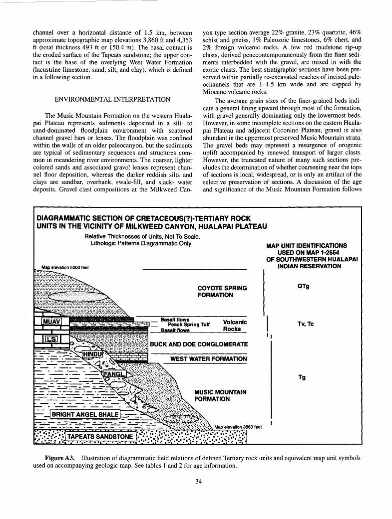
channel over a horizontal distance of 1.5 km, between approximate topographic map elevations 3,860 ft and 4,353 ft (total thickness 493 ft or 150.4 m). The basal contact is the eroded surface of the Tapeats sandstone; the upper contact is the base of the overlying West Water Formation (lacustrine limestone, sand, silt, and clay), which is defined in a following section.
ENVIRONMENTAL INTERPRETATION
The Music Mountain Formation on the western Hualapai Plateau represents sediments deposited in a silt- to sand-dominated floodplain environment with scattered channel gravel bars or lenses. The floodplain was confined within the walls of an older paleocanyon, but the sediments are typical of sedimentary sequences and structures common in meandering river environments. The coarser, lighter colored sands and associated gravel lenses represent channel floor deposition, whereas the darker reddish silts and clays are sandbar, overbank, swale-fill, and slack- water deposits. Gravel clast compositions at the Milkweed Can-
yon type section average 22% granite, 23% quartzite, 46% schist and gneiss, 1% Paleozoic limestones, 6% chert, and 2% foreign volcanic rocks. A few red mudstone rip-up clasts, derived penecontemporaneously from the finer sediments interbedded with the gravel, are mixed in with the exotic clasts. The best stratigraphic sections have been preserved within partially re-excavated reaches of incised paleochannels that are 1-1.5 km wide and are capped by Miocene volcanic rocks.
The average grain sizes of the finer-grained beds indicate a general fining upward through most of the formation, with gravel generally dominating only the lowermost beds. However, in some incomplete sections on the eastern Hualapai Plateau and adjacent Coconino Plateau, gravel is also abundant in the uppermost preserved Music Mountain strata.· The gravel beds may represent a resurgence of orogenic uplift accompanied by renewed transport of larger clasts. However, the truncated nature of many such sections precludes the determination of whether coarsening near the tops of sections is local, widespread, or is only an artifact of the selective preservation of sections. A discussion of the age and significance of the Music Mountain Formation follows
DIAGRAMMATIC SECTION OF CRETACEOUS(?)-TERTIARY ROCK UNITS IN THE VICINITY OF MILKWEED CANYON, HUALAPAI PLATEAU
Relative Thicknesses of Units, Not To Scale. Lithologic Patterns Diagrammatic Only
COYOTE SPRING FORMATION
Peach Spring Tuff Basalt flows
Volcanic Rocks
BUCK AND DOE CONGLOMERATE
WEST WATER FORMATION
MUSIC MOUNTAIN FORMATION
MAP UNIT IDENTIFICATIONS USED ON MAP 1-2554
OF SOUTHWESTERN HUALAPAI INDIAN RESERVATION
QTg
Tv, Tc
II
Tg
Figure A3. Illustration of diagrammatic field relations of defined Tertiary rock units and equivalent map unit symbols used on accompanying geologic map. See tables 1 and 2 for age information.
34

the description of the overlying West Water Formation, considered to be conformable with, and possibly gradational with, the underlying Music Mountain Formation
WEST WATER FORMATION
At the type locality for the Music Mountain Formation in Milkweed Canyon, the arkosic sediments grade upward into a 12-m-thick, white, lacustrine limestone, which is overlain by an interval of dark-red silt, clay, and sand. The fine-grained red sediments and white limestone were designated the West Water Formation by Young (1966). The apparently conformable contacts associated with the changes in facies and grain size suggest a ponding episode within the paleocanyon, accompanied by the permanent disruption of through-flowing drainage. The top part of the red sediments exhibits well-developed paleosol characteristics, including blocky to prismatic and columnar jointing (ped structures). In comparable stratigraphic sections where white limestone beds are absent (for example, Hindu Canyon), the upper red arkosic beds of the Music Mountain Formation appear to grade upward into similar dark-red, lacustrine(?), weathered clay and silt associated with a similar episode of drainage disruption. However, where the distinctive limestone beds are absent it is not always easy to distinguish between weathered sections of the fine-grained arkosic silt in the Music Mountain Formation and the similar-appearing, red sediments that may represent contemporaneous lacustrine deposition throughout the interconnected paleochannel system at the close of Music Mountain time (Milkweed, Hindu, Lost Man, and Peach Springs Canyons; fig. A2).
The white limestone facies on the Hualapai Plateau are confined to locations within the major known paleovalleys; localities include Milkweed Canyon, Peach Springs Wash, and beneath the town of Peach Springs, Arizona, as recorded in several well logs (Young, 1979). The thickest sections of the white limestone are within the paleovalleys at Milkweed Canyon and beneath the town of Peach Springs; both localities are immediately up gradient from the intersections of the ancient canyons with large monoclines. The locations of the thick limestone facies on the upstream sides of the monoclines suggest that the limestone beds probably formed as the result of structural damming of drainage during movement along the compressional Laramide structures (Young, 1979). The evidence for syndepositional deformation along the monoclines is especially compelling in the well logs at the town of Peach Springs where >100-m-thick limestone beds in four deep wells record apparent structural offsets of 23-35 mover a horizontal distance of 250m (Young, 1979). The thicknesses of the limestone beds recorded in the well logs also change abruptly across the projected axis of the buried Peach Springs monocline. One well log records a 1-m-diameter granite boulder within the limestone on the downthrown side of the structure and may be evidence of tectonism during limestone deposition (Young, 1979).
The West Water Formation is named for excellent exposures at and near the junction of West Water Canyon, a major tributary of Milkweed Canyon. Outcrops are scattered
35
throughout sec. 17, T. 26 N., R. 13 W., in the Milkweed Canyon, NW quadrangle. The most complete, best exposed, vertical section through the West Water Formation (with both upper and lower contacts clearly visible) is the section contiguous with the Music Mountain type locality described in this appendix.
The lacustrine origin of the red sediments that grade upward from the Music Mountain Formation is unclear at some other locations within the paleocanyon system, especially where limestone beds are absent. Perhaps the Iake(s) did not uniformly fill the entire paleocanyon system due to the presence of local structural barriers or landslides formed as a result of the tectonism inferred to have dammed the drainage. Alternatively, any relatively thin lacustrine facies may have been partially or completely eroded away during creation of the obvious disconformity between these older sediments and the overlying Buck and Doe Conglomerate. For example, -at the inferred stratigraphic position of the West Water Formation near Red Spring in Peach Springs Wash, (Upper Peach Spring on some older maps), two thin ( < 1 m) exposures of red and greenish claystone interbedded with a 20-cm-thick white marl bed exist within a thicker sequence of dark-red clay, silt, and sand. This local marl and claystone outcrop was later destroyed by road construction, but the remaining red silt and clay interval is approximately 32m thick (Young, 1966, p. 119; SE 114, sec. 11, T. 25 N., R. 11 W., Peach Springs, Arizona, 7.5-minute quadrangle).
Along the southern edge of Hindu canyon in poorly exposed outcrops, approximately 6-12 m of weathered, dark-reddish silt and clay are between the Buck and Doe Conglomerate and the underlying Music Mountain Formation. However, neither limestone nor marl facies have been identified in Hindu Canyon, and the poorer quality of exposures makes the study of the deeply weathered red sediments more difficult in Hindu Canyon. The dark-reddish lacustrine(?) silt and clay, which are in gradational contact with the Music Mountain Formation in Hindu Canyon, are assumed to represent the same transitional environment that appears to have signaled the end of through-flowing drainage throughout the Hualapai Plateau and the onset of an interval of localized ponding initiated by structural drainage disruption (Young, 1979).
Outside of the deep paleochannels on the surface of the Hualapai Plateau, ponding is less likely to have occurred·, and lacustrine sequences may not always mark the transition between the Music Mountain Formation and overlying units. On local divides between major paleodrainages very little sediment may have accumulated. A period of prolonged weathering and erosion appears to have followed the disruption of the drainage within the paleocanyons, during which time local sediments were reworked and transported from local divides toward adjacent depressions. This period of erosion, weathering, and reduced deposition was followed by an abrupt(?) influx of locally derived limestone pebble conglomerate (Buck and Doe), implying the passage of sufficient time to permit a significant climatic transformation. A marked transition to a drier climate would have been necessary to achieve the removal of any thick, protective soil cover that would have been present under humid conditions. Soil removal and the

displacement of established floral commumties, both of which would suppress the generation of gravel from the local limestone bedrock during the climate of Music Mountain time, would precede the gradual production of limestone-dominated gravel. The failure of some modern limestone terranes to produce coarse clastic debris is generally attributed to subtropical or tropical climatic conditions, which are characterized by efficient chemical weathering beneath thick, lateritic soils.
. Other evidence supportive of a marked change in climate following West Water time is the local abundance of fossilized indigenous trees in the Music Mountain Formation. Large silicified logs with delicate outer bark structures preserved are common in the middle of the formation in Peach Springs Wash. Some partially exposed fossil logs are over 40 em in diameter and exceed 2m in length (Young, 1966). Evidence of indigenous vegetation is missing from the poor fossil record in the coarser (Scott-type) braided channel gravel that dominates sediments deposited after West Water time.
The deep weathering of the West Water Formation probably continued during the inferred interval of post-Laramide structural quiescence (most likely some part of middle Eocene through middle Oligocene time) prior to the onset of middle Tertiary volcanism and associated Basin and Range extensional faulting. Disruption of through-flowing, northward drainage onto the Hualapai Plateau and the recognized worldwide change to cooler, drier, post-Eocene climates (Ridgway and others, 1995) may have _been associated with the change from continental red bed deposition and pronounced chemical weathering to carbonate-clast-dominated gravel deposition on the Hualapai Plateau.
EVIDENCE FOR AGE OF MUSIC MOUNTAIN AND WEST WATER FORMATIONS
The Music Mountain and West Water Formations represent sediment accumulation from sources external to the modern Colorado Plateau during an extended period of relatively uninterrupted deposition. This conclusion is supported by the lack of a significant unconformity separating the formations, the similar degree of weathering throughout both units, and the dominant red oxidation colors of the sediments. It seems reasonable to infer that structural disruptions of the magnitude required to block or divert the streams flowing through such large paleocanyons would probably result in local ponding of streams within such a deeply incised regional drainage system.
The interval of time during which these two related sedimentary units were deposited can be estimated by several methods: (1) age determinations on the oldest known overlying volcanic rocks, which provide an upper limit of late Oligocene time, (2) correlation with the most likely regional tectonic events known to predate the volcanic rocks and compatible with the depositional setting of the sediments, (3) measurement of radiometric ages of clasts within the deposits, which provide limits on the maximum age of the gravel units, ( 4) paleomagnetic poles recorded by the sediments, (5) fossils, (6) dating of volcanic ash interbeds, and (7) comparison of the sequence of tectonic events
36
recorded in the entire Hualapai Plateau sedimentary column with similar, better-dated fluviolacustrine and volcanic sequences in regions adjacent to the Hualapai Plateau in southwest Utah and eastern Arizona.
DISTRIBUTION AND REGIONAL CORRELATIONS
The Music Mountain Formation and its stratigraphic equivalents can be traced nearly continuously over a distance of more than 150 km from the Grand Wash Cliffs to the vicinity of Long Point on the Coconino Plateau (fig. AI; Geologic Map of Arizona, map unit Tso, Reynolds, 1988). Short gaps of less than 1 km separate some surficial outcrops over this broad region, but the extent of the arkosic sediments and related lag gravel is actually somewhat more continuous than can be accurately depicted on the relatively small-scale Geologic Map of Arizona (Reynolds, 1988). Detailed mapping of numerous gravel outcrops on the eastern Hualapai Plateau is contained on maps in U.S. Geological Survey Open-File Reports 86--458-A (Wenrich and others, 1986) and 86-458-B (Billingsley and others, 1986), companion reports to the present study. R.A. Young (1987, 1993, unpub. data, 1995) has completed field reconnaissance on a wide variety of undisturbed gravel exposures east and south of the Hualapai Reservation. From the range of exposures throughout this larger area the following age constraints for the basal arkosic units have been obtained: (1) Early Miocene and late Oligocene volcanic rocks rest unconformably on the arkosic sediments (Young and McKee, 1978), (2) Paleogene gastropods are in freshwater limestones interbedded with the arkosic sediments (Young and Hartman, 1984), and (3) K/Ar age determinations ranging between 65 Ma and 117 Ma (nine of the ages fall between 70 Ma and 83 Ma) were obtained from 13 exotic volcanic clasts collected from several gravel units, including localities on the Hualapai and Coconino Plateaus (Young, 1989; E.H. McKee, U.S. Geological Survey, written communs., 1988-94). The specific relevance of these scattered data sets to the probable age of the Music Mountain Formation on the Hualapai Plateau is discussed below.
REGIONAL OROGENIC EVENTS
The period representing channel erosion and subsequent deposition of the Music Mountain Formation and the closely related overlying West Water Formation probably is related to the lengthy period of regional tectonism, uplift, and thrust faulting associated with the Late Cretaceous to Eocene Laramide events that are documented south and west of the Colorado Plateau in Arizona, Nevada, Utah, and New Mexico (Goldstrand, 1992, 1994; Potochnik, 1989; Leventhal and others, 1995). This is the most obvious, pre-Oligocene, regional tectonic episode of sufficient magnitude that can account for: (1) the broad regional erosion surface preserved below the Cretaceous(?)-Tertiary sediments on the Colorado Plateau, (2) the deeper incision (uplift) of paleodrainages closer to the Colorado Plateau margin, (3) the Precambrian rock types of gravel clasts

derived from uplifted sources south and west of the modern Colorado Plateau boundary, and (4) the pervasiveness of Late Cretaceous exotic volcanic clasts in some of the gravel. The similar sequence of events in southern Utah between Late Cretaceous and middle Eocene time may have approximately paralleled the timing of similar events in Arizona (Goldstrand, 1990, 1992, 1994).
This lengthy interval of Laramide deformation is inferred to have included multiple pulses of tectonic deformation and volcanism, accompanied or separated by episodes of erosion and deposition. Areas such as the Hualapai Plateau, record the indirect effects associated with episodic uplift and deformation adjacent to such an orogenic environment. The most obvious evidence of Laramide compressional tectonism and uplift on the Hualapai Plateau are the prominent monoclines and the northeast-sloping erosion surface that bevels the northeast -dipping Paleozoic strata, whose dips steepen toward the Plateau margin. The Laramide uplift that bordered the Colorado Plateau margin also provided the relief needed to incise the northeast-trending paleocanyons, which deepen and widen in their headward reaches, closest to the former uplifts.
Music Mountain Formation gravel clasts on the Hualapai Plateau record (in ascending order) the unroofing of the Paleozoic platform sedimentary rocks, followed by younger Precambrian quartzites, then by metamorphic basement rocks, and finally, by an influx of silicic volcanic porphyry clasts that have yielded radiometric ages in the range from 63 Ma to 117 Ma on 13 widely spaced samples (Young, 1993). Published regional studies that contain syntheses of radiometric ages on potential igneous source rocks for the volcanic clasts give a range of ages between 65 Ma and 110 Ma for a Late Cretaceous magmatic episode in the Mohave Desert (Leventhal and others, 1995). A broadly similar range of ages for Cretaceous volcanic and plutonic rocks has been compiled from central Arizona (Reynolds and others, 1986). The similarities in ages between the Hualapai Plateau gravel clasts and volcanic rocks in adjacent provinces lend support to the interpretation that Laramide volcanic centers were the sources of the volcanic clasts shed from the uplifted terranes onto the Hualapai Plateau.
Numerous papers in the last decade have documented the general synchroneity of tectonic uplift and deposition of coarse clastic units adjacent to elevated source terranes in major orogenic belts (see Jacobson and Nichols, 1982). On the eastern Hualapai Plateau and Coconino Plateau, a significant influx of volcanic clasts appears high within some gravel sections. This relationship logically can be explained only if significant volumes of volcanic source rocks to the south were extruded late in a series of orogenic events that generated gravel and provided sufficient gradients for its northward transport. Otherwise, if erosion and gravel transport lagged significantly behind uplift and volcanism during orogenesis, the youngest volcanic rocks should have been among the first source rocks to be stripped from the uplifted region, and would be more abundant near the bases of the arkosic gravel sections, rather than near the tops, as observed.
The three volcanic clast ages obtained from the base, middle, and top of the Music Mountain Formation in Peach
37
Springs Wash show an increasing age trend upward through the section. Although any trend based only on three clasts must be considered preliminary data, taken at face value, the age trend supports a simple model whereby the youngest, highest rocks in the southwestern source region were eroded first, followed by older volcanic rocks, which then were deposited in reverse stratigraphic order. In any event the bulk of the volcanic clast ages, which are between 70 Ma and 83 Ma, suggest that much of the gravel deposition probably occurred no earlier than very latest Cretaceous or early Paleocene time.
FISSION TRACK UPLIFT DATA
Tectonic activity coincident with uplift and erosion along co-linear faults and monoclines in the western Grand Canyon has been described by Naeser and others (1989) from fission-track data. These events cluster around two maxima, one at 63 Ma and another between 35 Ma and 40 Ma, indicative of continuing middle- to late-Laramide regional uplift and erosion.
Limestone conglomerate units immediately overlying the Music Mountain Formation in Peach Springs Canyon contain small folds that are cut by a low angle reverse fault (S 112 sec. 35, T. 26 N., R. 11 W., Peach Springs, Arizona, 7.5 min. quad.). Such compressional structures, along with the evidence for syndepositional deformation of the West Water limestone during monoclinal disruption at the town of Peach Springs (Young, 1979), support the inference that compressional Laramide tectonism may have accompanied and followed the accumulation of Music Mountain and West Water sediments. Deformation of the gravel is compatible with the results of Naeser (1989) that suggest uplift continued through late Eocene time.
RELATED STRATIGRAPHIC SECTIONS: COCONINO PLATEAU
Arkosic, gravel-bearing sediments that apparently formed in identical environments to the Music Mountain Formation are traceable eastward onto the adjacent Coconino Plateau (fig. A1). Several thick, undisturbed sections of arkosic sediment and gravel, very similar in appearance to sections of the Music Mountain Formation in Milkweed and Peach Springs Canyons, are exposed in north-facing escarpments along the edge of the Mt. Floyd volcanic field near Long Point (50 km south of Grand Canyon National Park; fig. A1). The similar stratigraphy, sediment composition, weathering characteristics, and the presence of limestone beds within the Long Point deposits permit a tentative correlation of the arkosic sediments throughout the Hualapai and Coconino Plateaus. Some of the limestone-bearing Coconino Plateau sections were identified during a study focusing on the Kaibab Formation by Squires and Abrams (1975), who supplied the author with an unpublished map and field notes (R.A.Young, unpub. data, 1995).
Many arkose and gravel remnants that are in the flatter, more open terrain found on the eastern Hualapai Plateau

and adjacent Coconino Plateau are poorly exposed, and the ground surface is typically veneered with lag deposits derived from the most resistant rock types, typically quartzite, chert, silicic volcanic clasts, and silicic metamorphic rocks. It seems reasonable to assume that the weathered arkose and associated gravel deposits spread across this broad region represent very similar environments of deposition. The gravel represents a potentially lengthy period of time that was dominated by a uniformly humid climate and that was punctuated by Laramide tectonism. Thus, while similar in appearance, the arkose or gravel in specific localities might have quite different ages, ranging from Late Cretaceous to middle Eocene time.
PALEONTOLOGY: LONG POINT LIMESTONE BEDS
The arkosic sediments near Long Point contain fossiliferous lacustrine limestones bearing viviparid gastropods of probable pre-middle Eocene age that are well exposed at a locality named Duff Brown Tank, in sec. 28, T. 26 N., R. 3 W., on the Howard Spring, Arizona 7 .5-minute topographic quadrangle (Young and Hartman, 1984; Hartman, 1984). The fossil-bearing beds are near the middle of a >59-m section of exposed arkosic sediments, which are capped by middle Miocene basalts (McKee and McKee, 1972) and are obscured by colluvium near the base of the section. A well was drilled through the basalts that cap the viviparid-bearing section only 2.5 km northwest of Duff Brown Tank. The well penetrated 76.5 m of unconsolidated sediment beneath the basalts and ended in boulders, apparently close to the estimated top of bedrock, as projected from nearby bedrock outcrops (McGavock, 1968). The greater thickness of sediment measured at the well is assumed to be a better measure of the preserved local thickness of the arkose and gravel. Also, the well log may provide a better indication of the relative stratigraphic position of the limestone within the preserved sedimentary sequence than can be obtained from the partially obscurred section at Duff Brown Tank. The top of the limestone at the well site is 67 m below the basalt contact, and the well log indicates "lime" beds are in an interval of 9.5 m near the base of the boring. Most of the gastropods collected at Duff Brown Tank were from the lowermost of several thin limestone beds, which are within an interval of reddish arkose, silt, and clay.
Hartman (1984), who has extensively studied and revised the systematics of the middle Eocene and older Viviparidae in western North America, feels the Long Point specimens are most similar to Viviparus Meeki ( = V. trochiformis) and "probably part of a complex of related taxa" of "probably early Eocene" age (J.H. Hartman, written communs., 1983, 1984). The limestone beds also contained less well studied gastropods, including specimens from the genera Physa and Lioplacodes. All these gastropod genera are also found in the Flagstaff Member of the Wasatch Formation in Utah (La Rocque, 1960), formerly the Flagstaff Formation, and now known to be of late Paleocene age (Ryder and others, 1976). Goldstrand (1994) reported finding Viviparus trochiformis, Goniobasis sp., and Physa sp. in the Claron Formation in southwestern Utah, a formation he has recently determined to be late Paleocene to middle or late Eocene in age.
38
Charophytes are also present in the same limestones at Duff Brown Tank. They were identified by R.M. Forrester as a new species of nitellopsidoide charophyte, probably of the genus, Gyragona, presently known to range from lower Eocene to middle Oligocene time, but most common in lower to middle Eocene rocks (R.M. Forrester, U.S. Geological Survey, written commun., 1984).
Stromatolitic algal forms and vertical tube structures (presumed trace fossils) are very common in individual limestone beds, which average 10-40 em thick in the Long Point area. The thickest limestone outcrops are on the west side of Long Point at a map locality named Black Tank, where the thickness exceeds 15m, and may exceed 27m, at a partially covered section capped by basalt (NE 114, sec. 15, T. 26 N., R. 4 W., Black Tank, Arizona, 7.5-minute quadrangle, 1980 edition). However, only rare gastropod specimens from the genus, Physa, were collected from these thicker limestone beds.
All the fossil occurrences and their presumed affinities with better dated rocks in southwestern Utah suggest the upper part of the Long Point section is most probably late Paleocene to early Eocene in age. The gastropods noted above are typical of genera described in the literature from rocks on the Colorado Plateau no younger than Eocene in age (LaRoque, 1960; Hartman, 1984).
The limestone-bearing arkosic sections from Long Point westward to the Hualapai Indian Reservation are capped by middle Miocene basalts with an age of 14.0 Ma (McKee and McKee, 1972). Exotic volcanic clasts from gravel units in the same Long Point area have age ranges between 63 rna and 81 Ma (5 random samples). The radiometric ages on the flows and clasts limit the age of the arkosic units to between Late Cretaceous and Early Miocene time, an overly broad range that brackets the shorter, late Paleocene to early Eocene age estimate for the fossiliferous limestone within the Long Point section.
SIGNIFICANCE OF LATE CRETACEOUS-EARLY PALEOCENE(?) VOLCANISM
The stratigraphic sections from which clast counts were taken near Long Point and on the eastern Hualapai Reservation have the highest percentage of volcanic clasts in their uppermost beds of any of the sections studied. One Long Point section contains gravel with the following clast percentages: 56% exotic volcanic rocks, 25% quartzite, 13% schist and gneiss, 3% sandstone, and 3% chert (location: Little Baldy Tank; NE 1/4, sec. 33, T. 27 N., R. 3 W., Tin House, Arizona, 7 .5-minute quadrangle). A pebble count completed high in the stratigraphic section near the Thornton Lookout turnoff on the Supai Road (eastern Hualapai Reservation) has a similar clast distribution consisting of: 43% exotic volcanic clasts, 13% quartzite, 15% schist and gneiss, 6% sandstone, 14% chert, and 9% granite (location: sec. 9, T. 28 N., R. 7 W., Frazier Wells, Arizona, 7.5-minute quadrangle). The increase in the percentage of volcanic clasts upward in the two sections suggests that the uppermost beds of the Music Mountain Formation were derived from source rocks that were not present during

early erosional unroofing of the orogenic belt. It seems likely that the volcanic clasts represent a change in sourceland composition attributable to Late Cretaceous volcanism. This interpretation implies that, regionally, the gravel units reflect penecontemporaneous changes occurring in the orogenic belt, a relationship that can be presumed to restrict the age of the volcanic-clast-bearing gravel units to latest Cretaceous or early Paleocene time.
PALEOMAGNETIC AGE CONSTRAINTS
An attempt was made to obtain paleomagnetic pole positions from the sediments associated with the fossils near Long Point and by sampling other suspected early Tertiary localities in Arizona and southern Utah (Elston and others, 1989). Due to the weathered nature of most outcrops this effort was not entirely successful. However, some useful data were collected, and the overall results indicated a predominance of magnetically reversed samples (Elston and others, 1989). Such a result, in and of itself, implies a limit of 84 Ma (Late Cretaceous) for silty beds near the base of the Long Point sections, assuming any magnetically reversed strata must postdate the Cretaceous "long normal" magnetic polarity interval known to extend from about 118 Ma to 84 Ma.
The most stable, consistent paleomagnetic sample results, obtained from two beds near the base of a section west of Long Point, provided antiparallel (normal and reversed) anomalous, low inclinations, not compatible with the average pole positions normally recorded in Paleocene or Eocene rocks in North America. However, there are reported instances of reverse-polarity sediments with anomalously low inclinations during late Paleocene and early Eocene time. For example, the Black Peaks Formation in Texas (Rapp and others, 1983) has a similar paleomagnetic signature and has been assigned a Clarkforkian age (late Paleocene-early Eocene), compatible with the fossil evidence from the limestone section at Long Point.
SUMMARY OF AGE DATA
The similarities in the regional stratigraphy of arkose and gravel deposits from the Grand Wash Cliffs across the Hualapai Plateau to the Coconino Plateau (Long Point), the uniformly oxidized, deeply weathered character of the mostly fining-upward sequences, and the pervasive occurrence of lacustrine limestone, imply a generally compatible sequence of events across this broad region. Collectively, the clast compositions, the volcanic clast ages, the limited paleomagnetic data, and the fossil evidence all suggest that the uppermost parts of some arkosic sections between the Grand Wash Cliffs and Long Point may represent events that extend into middle or late Eocene time. However, the widespread erosion surface and paleocanyons beneath the older arkosic sediments may represent Late Cretaceous through Paleocene events. The history probably included the following sequence of events: ( 1) regional stripping of nearly all the Mesozoic rocks from the region by Late Cretaceous
39
time, (2) local deposition of Paleozoic-clast gravel units on some parts of the stripped surface accompanying widespread erosion (Robbers Roost gravels of Koons, 1948a, b), (3) incision of deep paleocanyons across the Hualapai Plateau contemporaneous with the regional erosion, ( 4) gradual filling and burial of the paleocanyons and intervening divides by arkosic sediments and gravel from sources south and west of the Colorado Plateau as older rocks were erosionally "unroofed" within the adja~ent orogenic belt, (5) structural deformation (including monoclines) accompanied by blockage of through-flowing, north-sloping paleocanyons and gradual, widespread drainage disruption, (6) deposition of limestone and fine-grained lacustrine sediments within disrupted paleocanyons (Peach Springs) or structural depressions (Long Point), and, lastly, (7) a period of undetermined length characterized by reduced tectonism and continued intense chemical weathering, probably corresponding to late Eocene through early Oligocene time. Events 2 through 6 may have overlapped temporally and spatially, depending on local conditions, such as distance from the Hualapai Plateau margin, the spatial distribution of structural deformation, and local relief.
YOUNGER LAG DEPOSITS DERIVED FROM MUSIC MOUNTAIN FORMATION
From latest Oligocene or Miocene time to the present, the weathered arkosic gravel and sediments of Late Cretaceous(?) to Eocene(?) age throughout the study area have been reworked into lag deposits, especially those outcrops that occupied high elevations. Although reworked gravel generally can be distinguished from parent deposits by careful field observations, the presence of multiple generations of reworked lag gravel complicates the establishment of an accurate geologic record. The key to distinguishing parent source beds from reworked younger lag deposits is the preservation (in the original deposits) of deeply weathered arkosic sediments, containing highly weathered and crumbling (but clearly visible) feldspathic clasts. These deeply weathered sediments record a Late Cretaceous-Eocene humid climatic interval and a probable depositional hiatus (unconformity) preceding mid-Tertiary extension and volcanism. By contrast, second (or higher) generation, reworked lag gravel deposits are conspicuously enriched in the most resistant rock types (quartzite, chert, pegmatitic quartz) and lack granite and other feldspar-bearing clasts seen in undisturbed, weathered outcrops of the original fluvial beds.
Direct confirmation of the long-term reworking of older gravel units on the eastern Hualapai Reservation was obtained from a road cut exposure that exhibits at least three generations of fluvial cut-and-fill gravel sequences. The base of the road cut exposed the Frazier Wells gravels of Koons, equivalent to the Music Mountain Formation. However, the uppermost channel in the sequence contained a fresh-appearing, interbedded ash that produced K-Ar ages between 1 and 3 Ma (R.A. Young and E.D. McKee, unpub. data, 1987; location: Supai Road, NW 1/4 sec. 1, T. 27 N., R. 8 W., Frazier Wells, Arizona, 7.5-minute quadrangle).

In many localities where only a thin veneer of re-sistant lag gravel remains, an accurate age assignment for such units may be impossible. A multigenerational origin for most surficial lag gravel, enriched in resistant clast rock types, should be assumed.
Other reworked gravel units that have similar compositions and origins are scattered across north-central Arizona (Young and others, 1987), as well as southern Utah. The problems associated with the establishment of an appropriate_ name for the so-called Rim gravels of Cooley and Davidson (1963) result, in part, from the confusion introduced by descriptions in the literature of reworked lag gravel units of uncertain affinities in several localities. An additional complication is caused by the original areal and vertical lithologic variations within the original gravel units themselves, which reflect the outcrop distributions of source rocks, and the progressive unroofing of uplifted Laramide terranes. It is unlikely that such widely dispersed sediments and reworked lag deposits can ever be adequately correlated or directly related in a detailed time sequence, given the fragmentary nature of the remaining undisturbed outcrops, and the difficulty of absolute age determination at any single outcrop.
POTENTIAL CONFUSION WITH OTHER GRAVEL TYPES
The characteristics of the Laramide arkosic deposits and their lag gravel derivatives cannot easily be confused with well-known lag deposits derived from the Shinarump Conglomerate Member of the Triassic Chinle Formation. Shinarump Conglomerate clasts have a very different appearance, a distinctive color (often yellowish) and a different surface texture (frosted patina common). Shinarump Conglomerate gravel units contain much higher percentages of quartz and chert, compared to the Cretaceous-Tertiary lag deposits. The gravel also contains distinctive and relatively abundant, well-rounded petrified wood clasts, and, most importantly, in northern Arizona the Shinarump lag gravel units have a significantly smaller mean pebble size (about 1-3 em; Stewart and other-§, 1972) than the Laramide gravel units. Even a cursory, visual comparison of Shinarump clasts with either the parent gravel or lag gravel from units like the Music Mountain Formation is sufficient to convince any skeptic that the two are very dissimilar.
HINDU FANGLOMERATE
The Hindu Canyon Formation of Gray (1964) included a "middle limestone conglomerate." The reddish-orange deposit is actually a poorly bedded, fanglomerate, which is commonly found along the walls of paleocanyons, near fault scarps, and along monoclines throughout the Hualapai Plateau. The unit is composed of locally derived colluvium and debris flows shed from paleocanyon slopes and tectonic scarps. It is distributed discontinuously in areas of relatively steep relief, and, for the most part, seems to have formed contemporaneously with the Music Mountain Formation, as demonstrated by sporadic interfingering between the two
40
units (see description of Music Mountain Formation measured section in this appendix). Although some isolated fanglomerate outcrops lack stratigraphic contacts with older or younger units, the reddish-orange color of the fine-grained matrix sandstone and mudstone indicates that the fanglomerate formed under the same humid climatic conditions that existed during the formation of the previously described lacustrine and fluvial deposits. The reddish hue and general appearance of the Hindu Fanglomerate are very dissimilar from the characteristics of the overlying (post-Laramide-age) buff to tan conglomerate units, all of which are dominated by clasts from the identical suite of Paleozoic limestones.
The distribution of the fanglomerate facies, its angular, locally derived clast rock types, and its association with steep slopes and tectonic scarps all indicate that it formed as debris flows, avalanche deposits, and mass-wasted colluvium. Deposition at the foot of steep slopes may have been enhanced during presumed episodes of active Laramide seismicity. Some Paleozoic limestone blocks derived from local bedrock exposures and incorporated in the fanglomerate exceed 2 m in their longest dimension. The steep walls that resulted from the incision of the paleocanyons would have produced occasional landslides or built debris fans into the adjacent fluvial channels, even in the presence of thick soils and dense vegetation.
Given the contrasting stratigraphy and local origin of the Hindu Fanglomerate, it should be mapped as a unit distinct from the Music Mountain Formation, in the same way that Recent colluvium (Qc) is mapped as distinct from Recent alluvium (Qal). The revised name, Hindu Fanglomerate, is chosen to recognize the work of Gray ( 1964) by retaining a part of his proposed terminology. Although Gray did not include detailed section descriptions in his 1964 paper, several section locations are contained in his thesis (Gray 1959). The Hindu Fanglomerate was not described previously by other workers on the Hualapai Plateau, and the "Fanglomerate" designation in the formal name clearly distinguishes the character of the unit from all the other Tertiary fluvial deposits redefined in this paper.
REVISED STRATIGRAPHY: POST -LARAMIDE-AGE SEDIMENTS
BUCK AND DOE CONGLOMERATE
The Buck and Doe Conglomerate as defined by Gray ( 1964) in Hindu Canyon is a coherent mapping unit, separated from the underlying Music Mountain and West Water Formations by a distinct disconformity. However, as mentioned above, Gray miscorrelated exposures of Buck and Doe Conglomerate in Hindu Canyon with a distinctly younger, post-Peach Spring Tuff gravel near Milkweed Canyon that is the most widespread, surficial Tertiary deposit present on the surface of much of the Hualapai Plateau. The Buck and Doe Conglomerate is readily distinguished from this younger, post-volcanic unit (Willow Springs Formation ofYoung, 1966; Coyote Spring Formation, this report, table

1) by the former's position beneath local basalt flows and the lack of Miocene volcanic clasts in most outcrops.
The name, Buck and Doe Conglomerate, as generally proposed by Gray ( 1964) in the Hindu Canyon region, is established and redefined as the formal name of the conglomerate normally found unconformably overlying the Music Mountain and West Water Formations. Because Gray (1964) did not correctly designate a formal type section for the Buck and Doe Conglomerate from among his several measured sections in Hindu Canyon, a principal reference section in Milkweed Canyon is selected. As noted above, Gray's (1964) designated section locations were found to be in error by Young (1966).
The most serious error by Gray (1964) is his statement that the Buck and Doe "overlies the Hindu Canyon Formation" (Music Mountain Formation), whereas, in a separate paragraph on the same page, he states that the Hindu Canyon Formation consists of "conglomerate, sandstone, and siltstone which interfinger with the overlying Buck and Doe Conglomerate." These statements cannot be reconciled with relationships as currently mapped across the Hualapai Plateau. Both of the statements and Gray's general description of the regional geology overlook the obvious unconformity between the Buck and Doe and underlying rocks.
The Buck and Doe Conglomerate name is formally redefined as a locally derived fluvial deposit that underlies all local volcanic rocks on the Hualapai Plateau. The unit has an upper gradational contact with local volcaniclastic sediments. The designated principal reference section in Milkweed Canyon is the same section used as the type locality for the Music Mountain Formation and the West Water Formation. The Buck and Doe Conglomerate occupies the same stratigraphic position in both Milkweed and Hindu Canyons, but both the lower and upper contacts are well exposed in Milkweed Canyon. In the thicker Milkweed Canyon exposures there is also a gradual upward change in clast composition within the unit. An influx of clasts from Precambrian rocks and Tapeats Sandstone is near the top of the unit in its westernmost outcrops, and the Buck and Doe Conglomerate generally grades upward into the overlying volcaniclastic beds within an interval of 1 or 2m.
VARIATIONS ACROSS THE HUALAPAI PLATEAU
The Buck and Doe Conglomerate is predominantly a carbonate-clast gravel dominated by material derived from Upper Cambrian through Mississippian formations, which crop out on nearby scarps and divides. Locally, the conglomerate may contain clasts derived from stratigraphically higher Pennsylvanian and Permian rocks. The clast compositions generally reflect the proximity of gravel outcrops to local bedrock divides or scarps. For example, outcrops of Buck and Doe in areas closer to the Grand Wash Cliffs contain more clasts from lower Paleozoic and Precambrian rocks (from Proterozoic granite and schist upward through Devonian dolostone). Outcrops to the north, nearer the Grand Canyon and Shivwits Plateau, contain a higher proportion of clasts from Mississippian through Permian rocks.
41
In upper Peach Springs Wash, the Buck and Doe Conglomerate consists of two distinct members, separated by a poorly exposed contact. The less-well-cemented upper member contains a significantly greater percentage of Precambrian clasts, reflecting the broader exposures of Precambrian crystalline rock types flanking the adjacent Truxton Valley (fig. A2), which was the headwaters for drainage entering Peach Springs Canyon. The upper member has an overall, more arkosic composition, similar to the Music Mountain Formation, but the clasts in the upper Buck and Doe Conglomerate are much less weathered, and the more exotic rock types seen in the underlying Music Mountain Formation are lacking. Individual clasts within the upper member of the Buck and Doe Conglomerate in Peach Springs Wash can be matched to distinctive rock types within the Truxton Valley area, such as the conglomeratic quartz mica schist of Slate Mountain and the granite near Valentine mapped by Beard and Lucchitta (1993).
The lower member of the Buck and Doe Conglomerate in Peach Springs Wash consists of approximately 14 m of well-cemented limestone conglomerate similar to that present in Milkweed and Hindu Canyons. The lower member unconformably overlies the red clay, mudstone, and arkose of the West Water and (or) Music Mountain Formations, and the contact relations are best exposed near Red Spring (sec. 14, T. 25 N., R. 11 W., Peach Springs, Arizona, 7.5-minute quadrangle).
ENVIRONMENT OF DEPOSITION
Textures and structures in the Buck and Doe Conglomerate indicate that the gravel was deposited in channels, gravel bars, and coarse sandbars in a braided river setting of the Scott type (Miall, 1977). Nearly all of the conglomerate was deposited as coarse to fine gravel beds with few sand lenses; clasts are subrounded to subangular. The unit is thickest within the paleochannels associated with the older Music Mountain Formation drainages (Young, 1989), but the unit also covers the intervening divides in areas of relatively low relief, especially around Hindu Canyon. The conglomerate appears first to have filled all the main channels and their local tributaries and then to have spread out to form a relatively uniform gravel blanket at elevations that range between 4,500 and 4,900 ft across the western Hualapai Plateau. At most outcrops the imbrication and cross bedding in the unit indicate stream flow away from areas of existing bedrock highs and toward adjacent areas of lower paleorelief.
On the Hualapai Plateau proper, the Buck and Doe drainages followed the already established, regional northeast dip from the western edge of the Hualapai Plateau toward the present position of the Colorado River. The inherited northeasterly direction of flow indicated by the paleochannels probably had been interrupted during West Water time, as earlier postulated, but local drainage appears to have been reestablished during late Buck and Doe time.
The influx ofPrecambian clasts toward the tops of stratigraphic sections, especially in the distinctive upper member in Peach Springs Wash, indicates the re-establishment of

limited northeast-directed, through-flowing drainage from west ofthe current Hualapai Plateau margin during late Buck and Doe time. The major difference between the westerly sources for the Buck and Doe Conglomerate and those for the older Music Mountain Formation is that local bedrock was the major source of clasts for the Buck and Doe, and few exotic clasts from great distances are present in the younger unit.
Deposition of the Buck and Doe Conglomerate documents a widespread, local aggradational episode across the entire plateau, in contrast to the regional incision of deep paleochannels prior to or during early Music Mountain time. The dark-orange-red soils, the conspicuous oxidation of fluvial sediments, and the advanced weathering of clasts seen in the older units are entirely lacking in the Buck and Doe Conglomerate. The character and distribution of the Buck and Doe indicate a drier climate, a lack of regional drainage incision, and the gradual burial of the local relief that existed at the close of Music Mountain time.
Deposition of the upper part of the Buck and Doe coincided with the onset of Miocene volcanism in areas west of the Hualapai Plateau, although some flows also erupted locally on the Hualapai Plateau proper. Basaltic volcanic clasts and sediments containing reddish cinders appear gradually in the upper gravel beds, followed by a sharp change to dominantly volcaniclastic sediments higher in local sections. Upsection these volcanic-bearing sediments give way, in turn, to coarser agglomerates and locally erupted basalt flows. At some localities the upper boundary of the Buck and Doe Conglomerate is gradational over a very short interval with the overlying Miocene volcaniclastic sediments. Based upon the appearance of isloated basaltic clasts in the Buck and Doe Conglomerate below any local basalt flows along the Grand Wash Cliffs, it appears that volcanism migrated from the west onto the present margin of the Hualapai Plateau. Regionally, the basalt flows on the Hualapai Plateau are dated between 14.6 Ma and 19.9 Ma (Wenrich and others, 1995; Reynolds and others, 1986; Young, 1989), consistent with the age and stratigraphic position of the Peach Spring Tuff (18.5 Ma), which is in most volcanic sequences. This short episode of early to middle Miocene volcanism seems to have marked the end of Buck and Doe Conglomerate deposition throughout the Hualapai Plateau, both within the paleochannels and on the intervening divides. Extensional faulting, assumed to have accompanied the Miocene volcanism immediately west of the Hualapai Plateau, may have locally severed the headward reaches of drainage basins that headed west of the present Hualapai Plateau.
Dated basalt flows, which cap the Buck and Doe Conglomerate north of Hindu Canyon, on the south edge of Grand Canyon demonstrate that the relief associated with the modern Grand Canyon and its major tributaries did not exist when the flows erupted about 19 Ma ago (Separation Hill basalt, Wenrich and others, 1995; Young, 1989). Some lavas flowed in an easterly direction down a shallow, gravel-filled paleochannel from a source west of modern Spencer Canyon (fig. A2). Both the Buck and Doe Conglomerate and the basalt flows that cap the exposure now are surrounded entirely by deep tributaries to the Grand
42
Canyon (Young, 1989). The existence of any channels, even with low relief, conforming to locations of existing tributaries to the modern Grand Canyon would have prevented either the gravel or the Miocene basalts north of Hindu Canyon from reaching their present location. Both the clast imbrication in the gravel and the elongate volcanic bubble cavities in the lavas demonstrate that paleogradients were toward the northeast at the very edge of the modern (west-flowing) Colorado River canyon (Young, 1989). Regionally, both the Buck and Doe Conglomerate and volcanic rocks into which they grade upsection, imply a lack of measurable erosion compatible with any Grand Canyon development in early Miocene time. In fact, deposition of the Buck and Doe Conglomerate demonstrates widespread fluvial aggradation, rather than drainage incision, at the very edge of the modern Grand Canyon, as well as throughout the area occupied by its modern tributaries on the Hualapai Plateau.
MIOCENE VOLCANIC ROCKS
The Miocene volcanic sequences, which provide an obvious upper limit on the time of cessation of Buck and Doe Conglomerate deposition, are largely the products of localized eruptions from vents on or immediately west of the Hualapai Plateau. No attempt is made in this article to comprehensively describe or correlate the dominantly basaltic volcanic flows and associated volcaniclastic sediments that are scattered across the Hualapai Plateau. The available whole-rock K-Ar ages for the Hualapai Plateau volcanic rocks associated with the sedimentary sequences described in this paper generally range in age from 14.6 Ma to 19.9 Ma (Wenrich and others, 1995; Reynolds and others, 1986; Young and McKee, 1978; Young, 1979; Young, 1989), but not all isolated outcrops have been radiometrically dated. The reader should consult Wenrich and others ( 1995) for a up-to-date, comprehensive compilation and discussion of the petrologic significance of the regional volcanic rocks.
The onset of more extensive local volcanism, accompanied by the breaching of the Hualapai Plateau margin by the Peach Spring Tuff and by basalts that originated from vents west of the present Hualapai Plateau temporarily reduced the relief between the modern Basin and Range province and the Hualapai Plateau. This is especially evident from the locations of sequences of basalt flows that fill former topographic low areas along the edge of the Grand Wash Cliffs between the mouth of Grand Canyon and the Truxton Valley (figs. 1 and 2). The vents for these flows have since been downfaulted and are at unknown distances to the west of the present Hualapai Plateau margin.
The thickest flow sequences are generally within the headward reaches of the old paleocanyons, and the Peach Springs Tuff of Young and Brennan (1974) (Peach Spring Tuff of this paper) thins to the northeast within the discrete lobes that flowed down individual canyons on the Hualapai Plateau. Field relations, a lack of erosional unconformities between volcanic units, and the similar weathered appearance of all the flows suggest they all have the same early to

middle Miocene age (as supported by the few radiometric ages available). All of the flows erupted prior to the erosion associated with the modern Colorado River tributaries. All of the basalt flows originally mapped by Young (1966) are stratigraphically between the Buck and Doe Conglomerate and the younger surficial gravel unit (Coyote Spring Formation, this report), all of which predate the main Colorado River erosion cycle.
Although Wenrich and others (1995) list late Miocene and Pliocene ages for small dikes and for flows within and north of Grand Canyon, it is doubtful that volcanic rocks younger than middle Miocene age are present in any signficant volumn on the south side of the Colorado River on the Hualapai Plateau proper. A small pluton of Laramide age (65.5 Ma, Young, 1979) is on the Grand Wash Cliffs at the head of Meriwhitica Canyon, where it is unconformably overlain by Miocene flows.
Volcaniclastic sediments, agglomerates, and cinder beds associated with local volcanic centers exist randomly across the Hualapai Plateau, but generally cannot be correlated to one another, except by their association with the Peach Spring Tuff. The period of basaltic volcanism on the Hualapai Plateau appears to have begun earlier immediately south of the Truxton Valley, where dates of latest Oligocene age are reported on flows bearing similar relationships to gravel sequences and to the Peach Spring Tuff in that region (Young, 1979; Young and McKee, 1978; Goff and others, 1983).
PEACH SPRING TUFF (PEACH SPRINGS TUFF OF YOUNG AND BRENNAN, 1974)
The most prominent rock unit in this volcanic section is the Peach Springs tuff (Young and Brennan, 1974), which provides a regional structural and stratigraphic datum for rocks throughout much of the lower Colorado River region. The informal name, Peach Springs tuff, has been widely used in the current literature for this key ash-flow tuff, which extends throughout the central Mohave Desert of California, into west central Arizona, and into southern Nevada, covering an estimated area of 35,000 km2 (Valentine and others, 1989). The unit was informally named by Young (1966) for its widespread occurrence on the western Hualapai Indian Reservation, in the Truxton Valley, and near the Town of Peach Springs, but no specific type locality was originally designated by Damon (1964) who dated the unit for Young, by Young (1966), or by Young and Brennan (1974).
Volcanic rocks mapped as Peach Springs tuff (Young, 1966; Young and Brennan, 1974) were included in the "Kingman rhyolite series" of Thomas (1953), who noted that in a key exposure, "all the rhyolite is pyroclastic." Nevertheless, Thomas described the Kingman Rhyolite series (TKr) on his map of the Chloride district as including "rhyolite flows, tuffs, and agglomerates," and incorrectly correlated the series with both the Antelope Rhyolite and the Sitgreaves Tuff of the Black Mountains (Lausen, 1931). He did not propose a more formal designation for the rocks he mapped near Kingman, presumably because he assumed they were equivalent to rocks already named, which were
43
also inadequately defined by current standards. Thorson ( 1971) has since demonstrated that the Sitgreaves Tuff interfingers with multiple flows of "Antelope Rhyolite," redefined as Antelope Quartz Latite in the Oatman area. Antelope Quartz Latite flows yielded a range of Kl Ar ages that overlap the age of the Peach Spring Tuff.
NOMENCLATURE ISSUES
Between 1962 and 1966, Young (1966) mapped many Peach Springs tuff outcrops on the Hualapai Plateau and completed field reconnaissance of additional outcrops westward to the Cerbat Mountains near Kingman, Arizona, and southward along the Colorado Plateau margin to ~he vicinity of the Aquarius and Mohon Mountains. Initially, it was unclear that the apparently complex "rhyolite series" described by -Thomas in the Chloride quadrangle represented the same single ash-flow tuff. Additional studies of Peach Spring Tuff outcrops between 1969 and 1973 by Young and Brennan (1974) extended its known outcrop area and confirmed that the tuff, including Thomas's "Kingman Rhyolite series," was a single pyroclastic unit that consists of a thin stratified ash (surge) deposit, from which the overlying ash flow is separated by a minor (nonerosional) hiatus (Valentine and others, 1989). Some tuff outcrops erode to form two or more "benches" as a result of cooling effects and related jointing within the unit (Valentine and others, 1989), thus explaining the pseudo-layered appearance of some outcrops. Since the ash flow tuff is apparently a trachyte and not a "rhyolite" nor a "series" of flows, the geographic name "Peach Springs" for the tuff adopted by Damon (1964) and by Young (1966) and adopted by subsequent workers between 1966 and 1995 is more appropriate than the imprecise lithologic designation of "Kingman Rhyolite series" by Thomas (1953).
Approximately 20 formal publications and numerous meeting abstracts have reported on studies of the Peach Springs tuff, defining its age (Nielson and others, 1990), composition (Buesch, 1993), mode of deposition (Valentine and others, 1989), paleomagnetic direction (Wells and Hillhouse, 1989), probable source (Hillhouse and Wells, 1991), and its significance to the structural history of the lower Colorado River region (Glazner and others, 1986). The name has become firmly entrenched in the recent voluminous literature on the central Mohave desert, despite the prior established use of the geologic name "Peach Springs Member," for a subdivision of the Cambrian Muav Limestone in the Grand Canyon section (McKee and Resser, 1945). The name, Peach Springs tuff, is so well-established in the existing literature at this juncture that a complete change of the entire name would only create needless confusion. It is also very unlikely that the similar geographic designations for the Miocene ash flow and the Cambrian marine member of the Muav Limestone will be confused.
In order to correct some earlier mapping problems, a regional synthesis of units under the name, Peach Springs tuff, was proposed by Glazner and others (1986) who correlated named and unnamed informal map units throughout much of the central Mopave Desert (Redfire tuff, tuff of

Kane Wash, and other informal map units) as outcrops of the Peach Springs tuff as defined in Young and Brennan (1974). The usage of the existing informal names was dropped in favor of Peach Springs tuff following confirmation of the similar mineralogy and paleomagetic signature of the individual tuff exposures (Gusa and others, 1987; Wells and Hillhouse, 1989; Buesch, 1993).
PROPOSED FORMAL NAME CHANGE: PEACH SPRING TUFF
The modified name, Peach Spring Tuff, for the widespread ash-flow tuff first described by Young (1966) on the Hualapai Plateau should be retained for reasons of convenience and because of widespread established usage in the recent literature from 1964 to the present. Justification for the continued use of a slight variation of the informally established name, "Peach Springs tuff," would seem to be permitted under the recommendations in Section 7c of the North American Stratigraphic Code, which states: "Stability of nomenclature is maintained by the use of the rule of priority and by preservation of well-established names. Priority in publication is to be respected, but priority alone does not justify displacing a well-established name by one neither well-known nor commonly used; nor should an inadequately established name be preserved merely on the basis of priority." In order to formally distinguish between the use of the name "Peach Springs" for the Peach Springs Member of the Muav Limestone as well as for the Peach Springs tuff ofYoung and Brennan (1974), a formal name change to "Peach Spring Tuff' (singular), is proposed from the location of a spring appearing on older maps of Peach Springs Wash. Recent U.S. Geological Survey topographic maps have changed the name, Peach Spring, that appears on older maps, to "Peach Springs." However, older map editions, including the 1941 map of the Hualapai Reservation by the Office of Indian Affairs, identified three separate springs, Peach Spring, Lower Peach Spring, and Upper Peach Spring (now called Red Spring) along the road from Peach Springs Wash to the Colorado River. An outcrop of the Peach Spring Tuff is immediately south of the three springs (N 112, sec. 14, T. 25 N., R. 11 W., Peach Springs, Arizona, 7 .5-minute quadrangle).
TYPE LOCALITY
The best described localities and potential reference sections for the Peach Spring Tuff are now known to be at Kingman, Arizona, as a result of detailed mapping by G. A. Valentine and D. C. Buesch (Valentine and others, 1989; Buesch and Valentine, 1986). The thickest and most proximal outcrops of the Peach Spring Tuff are described in detail for a 75-m-thick section at Cook Canyon in Kingman (Valentine and others, 1989; fig. 5). Their comprehensive discussion of the nature and distribution of the Tuff currently serves to define the range of textures, rock types, and the inferred emplacement mechanism of this ash-flow unit. The proposed type locality is the section illustrated and described in Valentine and others ( 1989; fig. 5) and in
44
Buesch and Valentine, (1986, p. 8-11). Additional detailed measured sections are contained in these references and in a companion article (Valentine and others, 1990), resulting from a "Comment and Reply" exchange in the Bulletin of Volcanology (Wilson and Self, 1990; Valentine and others, 1990). The latter reference more clearly identifies the precise location of the measured sections and proposed type locality at the intersection of Interstate Highway 1-40 with Cook Canyon on the Kingman, Arizona, 7.5 minute topographic quadrangle map, (UTM Grid: 11SQJ667967; Lat. 35°10' 45" N.; Long. 114° 04' 24" W; NW 114, SW 114 sec. 26, T. 21 N., R. 17 W.). The detailed descriptions of the petrologic subdivisions within the Tuff, their detailed structures, textures, and mineralogy, as well as their mode of origin are beyond the scope of the present article, and the original descriptions by Valentine and others ( 1989, 1990) should be consulted for several pages of detailed descriptions. Additional mineralogical properties of the Peach Springs Tuff were described by Gusa and others (1987) and by Buesch (1993).
RELEVANCE TO AGE OF MUSIC MOUNTAIN FORMATION
Recognition of the Peach Spring Tuff as a widespread, early Miocene unit (Young, 1966) on the Hualapai Plateau is critical to the observation that the highly weathered arkosic gravel units near the base of the Hualapai Plateau Cretaceous(?)-Tertiary section are much older than either the Peach Springs Tuff (18.5± 0.2 Ma; Neilson and others, 1990) or the late Oligocene volcanic flows which underlie the Tuff in the Aquarius Mountains (Young and McKee, 1978). This argument hinges on the fact that clasts from Precambrian rocks in Buck and Doe Conglomerate between the Music Mountain Formation and the Miocene-Oligocene volcanic rocks show little evidence of chemical weathering, whereas similar clast rock types in the basal arkosic gravel are so completely weathered they crumble easily in the hand. This implies that the Music Mountain Formation clasts must have weathered under very different conditions, or for a considerably longer time, than the 19-25-million-year interval that has produced little visible alteration of similar clast rock types in gravel found immediately beneath late Oligocene to early Miocene volcanic rocks. The contrast in the degree of chemical weathering of the older gravel units can either be ascribed to a significant age gap between the two deposits or to an early period characterized by a much more humid climate, either of which imply an Eocene or older age for the basal arkosic sediments, based on regional geologic studies of North America.
COYOTE SPRING FORMATION
Young (1966, 1989) assigned the name, Willow Springs Formation, to widespread, post-volcanic gravel deposits on the Hualapai Plateau, not realizing that the same geographic name previously had been used for several other formations (Keroher, 1970). A new name, Coyote Spring Formation (fig. A3 ), is proposed for the unit and a type locality is designated

from the description in Young (1966, p. 122). At the type locality (SW 114 sec. 33, T. 27 N., R. 13 W., Milkweed Canyon NW, Arizona, U.S. Geological Survey 7 .5-minute quadrangle), the lower contact of the formation with the Miocene volcanic rocks is reasonably exposed and there are three visible subdivisions within the formation. The Coyote Spring Formation covers many square miles of the Hualapai Plateau surface surrounding the type locality. The thickest outcrops of the unit are accessible along the Buck and Doe Road, and Coyote Spring is a well-known, local landmark on the adjacent Grand Wash Cliffs (sec. 20, T. 26 N., R. 14 W.). The gravel exists locally over an elevation range of at least 183 m (600 ft) adjacent to and west of the type locality, a figure which may be closer to the maximum existing thickness of the unit. However, relief is low and exposures are poor in the areas far from canyon margins where limited headward erosion has not created adequate exposures.
Surface outcrops of the Coyote Spring Formation are generally obscured by development of the local soil cover or by lag gravel. The Coyote Spring Formation is being actively eroded by local drainage development across broad areas of the Hualapai Plateau that are at some distance from areas of active bedrock canyon incision. Colluvium formed on the lower slopes of hillsides grades into modem stream beds and provides much of the modem alluvial sediment filling local stream courses.
ENVIRONMENT OF DEPOSITION AND AGE
The Coyote Spring Formation is a locally derived fluvial unit that covers many divides and fills local basins throughout the Hualapai Plateau. The sediments represent the re-establishment of a braided stream depositional environment following the main episode of Miocene volcanism, which earlier had disrupted the older drainage and nearly completed the filling of any paleochannel relief that remained -after deposition of the Music Mountain, West Water, and Buck and Doe Formations. Most areas of the Hualapai Plateau and the Truxton Valley show evidence of widespread fluvial aggradation in Coyote Spring time. Drill-hole data from several wells near Truxton (Young, 1979) show as much as 114m of Coyote Spring sediments overlying basalts that are interbedded with Peach Spring Tuff.
When Miocene volcanism ended, erosion of local bedrock divides was renewed in areas not covered by volcanic rocks. The Coyote Spring Formation records this significant interval of fluvial sedimentation and aggradation throughout the Hualapai Plateau, a condition seemingly incompatible with the headward erosion and rapid canyon incision that must have accompanied development of the younger Colorado River. However, Colorado River erosion may have begun near the modem canyon while the late stages of Coyote Spring Formation deposition were still continuing in upstream tributary reaches far removed from the Grand Canyon. Currently, all of the Coyote Spring Formation is undergoing incision and removal by downcutting and headward extension of Colorado River tributaries.
It appears likely that the Truxton Valley was a separate, enclosed drainage basin before it was breached by headward erosion from both the west (Red Lake drainage) and the east
45
(Peach Springs Canyon). Thus accumulation of the Coyote Spring Formation sediments in the Truxton Valley may have continued longer in that semi-isolated basin than in tributaries graded directly to the Grand Canyon. Twenter (1962) reported Pleistocene fossils within some of the uppermost fine-grained sediments of the Coyote Spring Formation near the center of the Truxton Valley.
The age of the lower Coyote Spring Formation cannot be older than middle Miocene time, because initial deposition appears to have accompanied or immediately followed the end of local volcanism. In theory the Coyote Spring Formation might directly overlie Buck and Doe Conglomerate in places where volcanic rocks are absent. However, exposures of such a theoretical contact relationship have not been found. It is equally likely that the widespread, regional volcanic activity would have left a veneer of airborne volcanic sediments over a broad region outside the limits of the existing volcanic flows. Thus, any hypothetical contact between the lithologically similar Buck and Doe and Coyote Spring Formations may have preserved evidence of original or reworked volcanic ash, lapilli, or cinders corresponding to the episode of regional volcanism. The Coyote Spring Formation accumulated for an undetermined period, eventually ending as the incision of the Colorado River system altered local base levels through headward erosion southward across the Hualapai Plateau. However, it is unlikely that the Coyote Spring Formation will improve our understanding of the nature and timing of the transition from local deposition on the Hualapai Plateau to the widespread tributary incision that accompanied the development of the Grand Canyon. The potential range in age of the Coyote Spring Formation from middle Miocene to Pliocene(?) time, and the difficulty of determining the age of such unfossiliferous gravel, make it unlikely that further study of the unit will significantly improve our understanding of the timing of the initiation of Colorado River erosion.
SUMMARY
The Late Cretaceous(?) to Pliocene sedimentary sequence on the Hualapai Plateau contains one of the most complete records of Tertiary climatic change and deposition in Arizona. It appears to extend from the Laramide Orogeny through the interval that initiated late Miocene(?) or Pliocene Grand Canyon erosion. Ironically, the best record of the geologic events leading to the formation of the Grand Canyon appears to be in an area generally assumed to have undergone the most intense erosion and destruction of the Cenozoic record. Fortuitous protection of the best Tertiary sections in deep paleocanyons by volcanic rocks, including the widespread Peach Spring Tuff, has provided an extended record of Late Cretaceous(?) through Miocene history possibly unmatched on the Colorado Plateau.

MEASURED STRATIGRAPHIC SECTIONS AND TYPE LOCALITIES, HUALAPAI
PLATEAU CRETACEOUS(?) AND TERTIARY ROCKS
MUSIC MOUNTAIN FORMATION
Type section for Music Mountain Formation: Milkweed Canyon, Mohave County, Arizona (UTM Grid 12STQ562468; lat. 35° 38' 00" N; long. 113° 41' 40" W; adjacent parts of sec. 16 and 17, T. 26 N., R. 13 W., on the Milkweed Canyon NW, Arizona, 7.5-minute quadrangle, 1967 edition). Upper contact: sharp, apparently conformable, contact of white limestone with reddish Music Mountain Formation sediments below. Lacustrine limestone at contact includes transported clasts of Paleozoic limestone. Lower contact: Tapeats Sandstone, disconformable.
Description of section (thickness in meters) Top.
1.8 m-Reddish to whitish, silty calcareous arkose; locally contains local gray carbonate clasts (to 20 em diameter) from Paleozoic limestone that crops out in adjacent canyon walls. Becomes whiter and more calcareous upward to contact with overlying limestone.
19.8 m-Alternating beds of pinkish-red arkose and darker reddish siltstone; individual beds as much as 1m thick. Coarser and finer grained layers contain numerous white concretions (2-3 em), which increase in number upward. Concretions appear to represent downward transport and redeposition of carbonate from overlying limestone lake beds.
21.7 m-Mostly dark-reddish siltstone and thin beds of finer-grained, lighter-colored, pink arkose. Undulatory contacts with units above and below. Individual beds and lenses show subdued erosional effects at some contacts (fluvial scour).
8.2 m-Lighter, reddish to pinkish arkose containing uncommon, thin beds of darker mudstone. Unit contains a thi1;1 pebble lens of igneous and metamorphic clasts 1 m from upper contact. Most arkosic units have isolated Precambrian rock clasts within the finer-grain sediment.
8.3 m-Mostly dark-reddish siltstone with occasional beds of lighter (coarser) pinkish arkose.
9.1 m-Wedge of reddish-orange Hindu Canyon Fanglomerate interfingers with arkosic sediments (thickens toward adjacent canyon wall). Angular clasts are mainly of Cambrian through Mississippian limestone and dolostone in reddish-orange matrix of silt, clay, and sand. Fanglomerate rock types are derived from local canyon-wall outcrops, and unit projects from canyon wall northwestward into contrasting arkosic channel deposits. Hindu Fanglomerate is separate unit defined and described in this appendix.
46.9 m-Reddish to pinkish beds of arkose containing isolated clasts of igneous and metamorphic rocks with a small proportion of Paleozoic rock clasts from local sources (mostly limestones). Intervals in upper part
46
partially covered; restricted sediment outcrops only visible in small gullies. Reddish beds are finer grained; lighter, pinkish-white beds are coarser grained. Contacts between beds show irregular scour surfaces.
3.1 m-Gravel lens of mostly granite, quartzite, schist, and gneiss pebbles with average diameters from 5 to 10 em. Rock types similar to clast counts in 6.1-m interval below.
0.3 m-Bed of reddish arkosic silt and sand. 0.91 m-Gravel lens of rock types and abundances similar
to 6.1-m interval below. 4.6 m-Pinkish arkose containing few scattered clasts of
rock types below. 6.1 m-Gravel bed including some boulders as much as 60
em in long diameter. Count of 100 clasts, including weathered specimens: granite 19, quartzite 24, schist and gneiss 53, limestone 2, exotic volcanic rock (not of local origin) 1, chert 1. Additional clast count in adjacent tributary at same approximate stratigraphic level: granite 26, quartzite 21, schist and gneiss 39, foreign volcanic 3, chert 11. Volcanic clasts are silicic porphyrys, dissimilar from local Miocene basalts.
9.1 m-Partially covered interval containing arkosic siltstone, sandstone, mudstone, and gravel similar to those intervals described above, (poorly exposed under and between large boulders in side of modern stream bed). Gravel beds include occasional rip-up clasts of finer (overbank?) red mudstone that match the composition of intervening fine-grained beds.
0.6 m-Gravel lens containing clasts similar to those in 6.1-m-thick bed above.
3.1 m-Covered interval, obscured by boulders in side of modern stream bed. Appears continuous with gravel lenses above and below.
3.1 m-Lens of large boulders as much as 50 em in long diameter; larger boulders are mostly quartzite. Other clasts present are similar to rock types in pebble counts above.
3.7 m-Contact interval with Tapeats Sandstone on floor of modern, scoured bedrock channel. Includes discontinuous, irregular masses of weakly consolidated arkosi,c sediment that contains small, included cobbles that adhere to original irregular Tapeats Sandstone surface, which formed the base of paleochannel. Modern alluvium partially obscures contact. Elevation of basal contact estimated from Milkweed Canyon NW, Arizona, 7.5-minutequadrangleis 3,860±20ft(1176.5 m). Base. Total thickness of section 150.4 m.
WEST WATER FORMATION
Type section for West Water Formation: same locality as Music Mountain Formation location above. Upper contact: disconformable, overlain by base of Buck and Doe Conglomerate (Gray, 1964). Basal contac~: gradati?nal (conformable) with Music Mountain FormatiOn, descnbed above.
Description of section (thickness in meters). Top.

3. 7 m-Dark-red to dark-reddish-orange siltstone and claystone that has crumbly to blocky and prismatic ped structure in upper third, grading downward to more massive appearance. Sediment has structural appearance of thick paleosol, but lacks distinct mottling or other discernible discolorations that normally might indicate discrete soil horizons. Lower massive part of silt and clay unit lacks discernible evidence of bedding. Gradational contact with limy beds below. Appears to be highly weathered clay and silt formed during waning phase of underlying lacustrine carbonate deposition.
1.8 m-Pinkish-white, massive limestone containing clasts from Paleozoic limestone and rarer sandstone or quartzite clasts that appear to "float" in the limestone matrix; clast diameters are as much as 8 em. Gradational contacts with overlying silts and clays, and with whiter limestone below. Clasts appear to be derived from talus or colluvial debris shed into carbonate-forming environment of restricted lake basin from steep adjacent paleocanyon slopes.
12.2 m-Hard, massive, white, microcrystalline limestone forming a single coherent cliff. Outcrop locally contains open, discontinuous, parallel, horizontal cracks or partings suggestive of former bedding structure. These open cracks are approximately 1-3 mm wide and commonly spaced at 3-5 em intervals when present. A single, centimeter-long gastropod specimen of the Genus, Physa (similar to specimens collected at Long Point), is the only fossil specimen found in this limestone unit during numerous visits to this and adjacent sections between 1962 and 1993. Base. Total thickness of formation 17.7 m.
HINDU FANGLOMERATE
Type section for Hindu Fanglomerate: Lost Man Canyon, Mohave County, Arizona (UTM Grid 12STQ749514; lat. 35° 40' 40" N., long. 113° 29' 00" W; NE 1/4, NE 114, SW 114, sec. 31, T. 27 N., R. 11 W., Peach Springs Canyon, Arizona, 7.5-minute quadrangle, 1967 edition). The thickest continuous outcrop of Hindu Fanglomerate described by Gray ( 1959) is in a tributary on the south side of Lost Man Canyon. The fanglomerate is the lowest exposed Tertiary unit in the section; the base is hidden beneath deposits of Recent colluvium, typical of outcrops in areas of moderately steep slopes. Upper contact: Buck and Doe Conglomerate. Lower contact: covered.
Description of section (thickness in meters). Top.
12.3 m-Buck and Doe Conglomerate (disconformable with underlying unit).
38.4 m-Music Mountain Formation (Upper member of Hindu Canyon Formation of Gray).
4.1 m-Hindu Fanglomerate ( disconformable with units ·above and below). See below.
24.5 m-Arkosic sandstone and siltstone of Music Mountain Formation (disconformable with units above and below)
47
39 m-Hindu Fanglomerate. Unit consists of reddish-orange sandstone and siltstone in beds 30-60 em thick that separate thicker lenses of coarse fanglomerate consisting mainly of angular to subangular chert and limestone clasts (Redwall, Devonian, and Kaibab Formations with some Coconino Sandstone?). Bedding within finer units is irregular to absent, and unit forms irregular slopes; ledges mark resistant units; base covered. (Modified after Gray, 1959). Base. Total thickness of section 118.3 m.
MILKWEED CANYON SECTION
Principal reference section for Buck and Doe Conglomerate (located in same section immediately above type localities for Music Mountain and West Water Formations as described above). Upper contact: gradational with overlying volcaniclastic sediments associated with Miocene basalt flows and Peach Spring Tuff. Principal reference section is in Milkweed Canyon channel and stratigraphically above type section of West Water Formation, where over 1 km of the formation is well exposed in the main channel of Milkweed Canyon (Nl/2 sec. 20, T. 26 N., R. 13 W., Milkweed Canyon NW, Arizona, 7 .5-minute quadrangle, 1967 edition). Basalts directly overlie conglomerate beds in some places, but elsewhere a gradual increase in volcaniclastic sediment is sometimes observed within the top meter of Buck and Doe Conglomerate. Lower contact: abrupt and disconformable on underlying West Water Formation. Sharp contrast between buff to tan color of Buck and Doe Conglomerate and reddish orange color of West Water Formation. Well-cemented Buck and Doe Conglomerate outcrops usually form a vertical cliff and may create a slight overhang above underlying, unconsolidated, red sediments of Music Mountain or West Water Formations.
Description of section (thickness in meters). Top.
5 m-Limestone pebble conglomerate with subangular to subrounded clasts. Similar to beds below, but clasts show upward increase in percentage of small (em- to mm-size) oxidized volcanic cinders and volcaniclastic sandstone beds. Conglomerate completely cemented with calcium carbonate so that rock breaks across clasts and matrix (with difficulty). Coarse sand component is slightly greater in uppermost beds than in majority of gravel units below.
28.5 m-Limestone conglomerate with slightly coarser clasts than overlying beds and no evident volcaniclastic component. Gravel-dominant bedding is Scott type of Miall (1977); many beds show clast-supported texture. Gravel clasts show obvious imbrication and some beds are crossbedded. Thin, coarse-grained sand beds are rare. Individual gravel beds average 20-60 em thick. Overall color of units is tan to buff with conspicuous gray limestone clasts. Clasts are mainly Cambrian through Devonian Paleozoic rocks with rare igneous clasts that resemble Precambrian rocks in outcrops 8 km to southwest on Grand Wash Cliffs near head of present drainage. Rare, but easily noted,

clasts of Precambrian quartzite beach pebbles (conspicuous, well-rounded, symmetrical oval shapes) are present and were traced to beach-pebble units within Tapeats Sandstone outcrops also present along the Grand Wash Cliffs near the head of the modem Milkweed Canyon drainage. Imbrication indicates flow of currents to northeast within paleochannel. Size range of larger clasts is typically 5-15 em, some larger. Base. Total thickness of unit 33.5 m.
COYOTE SPRING FORMATION
Coyote Spring Formation type section: (UTM Grid 12STQ571517; lat. 35° 40' 40"N., long. 113° 40' 30" W; SWl/4 sec. 33, T. 27 N., R. 13 W., Milkweed Canyon NW, Arizona, 7.5-minute quadrangle, 1967 edition). General location is one half mile north of Harding Spring tributary of Milkweed Canyon. Upper Contact: none; forms local surface of plateau. Coyote Spring Formation is the youngest formal Tertiary map unit on the Hualapai Plateau. Lower contact: Miocene basalt flows. ·
Description of section (thickness in meters). Top.
52 m-Light buff to tan conglomerate with clasts predominantly derived from Cambrian to Mississippian Paleozoic limestone. Bedding - appears intermediate between Scott and Donjek types of Miall (1977), consisting of alternating gravel and gravel-sandstone lenses. Most sandy beds also have significant pebble content. Abundant local basaltic clasts and lesser degree of calcium carbonate cementation readily distinguish this formation from the prevolcanic Buck and Doe Conglomerate. Formation generally forms gradual slope with thin lag gravel and (or) thin to moderately thick soil cover; some steeper ledgy outcrops exist in areas of active stream erosion.
15.2 m-Crumbly, light-reddish to brownish sandstone, siltstone, and mudstone with indistinct bedding.
24.4 m-Conglomerate sequence similar to upper unit, volcanic clasts obvious. Base. Total thickness 91.6 m.
REFERENCES
American Association of Petroleum Geologists, 1983, North American Stratigraphic Code: American Association of Petroleum Geologists Bulletin, v. 67, no. 5, p. 841-875.
Beard, L.S., and Lucchitta, 1., 1993, Geologic map of the Valentine Southeast Quadrangle, Mohave County, Arizona: U.S. Geological Survey Geologic Quadrangle Map GQ-1711, scale 1 :24,000.
Billingsley, G.H., Wenrich, K.J., and Huntoon, P.W., 1986, Breccia-pipe and geologic map of the southeastern Hualapai Indian Reservation and vicinity, Arizona: U.S. Geological Survey Open-File Report 86-458-B, scale ~:48,000.
48
Blissenbach, E., 1952, Geology of the Aubrey Valley, south of the Hualapai Indian Reservation, NW Arizona: Plateau, v. 24, no. 4, p. 119-127.
Buesch, D.C., and Valentine, G.A., 1986, Peach Springs Tuff and volcanic stratigraphy of the southern Cerbat Mountains, Kingman, Arizona, in Cenozoic Stratigraphy, Structure and Mineralization in the Mohave Desert: Guidebook and Volume, Trips 5 and 6, 82nd Annual Meeting, Cordilleran Section, Geological Society of America, Los Angeles, California, p. 7-14.
Buesch, D.C., 1993, Feldspar geochemistry of four Miocene ignimbrites in southeastern California and western Arizona: U.S. Geological Survey Bulletin 2053, p. 55-85.
Cooley, M.E., and Davidson, E.S., 1963, The Mogollon Highlands-Their influence on Mesozoic and Cenozoic erosion and sedimentation: Arizona Geological Society Digest, v. VI, p. 7-35.
Damon, P.E., 1964, Correlation and chronology of ore deposits and volcanic rocks: Annual Progress Report to U.S. Atomic Energy Commission, Geochronology Laboratories, University of Arizona, 28 p.
Darton, N.H., 1925, Resume of Arizona Geology: Arizona Bureau of Mines Bulletin 119, 298 p.
Davis, W.M., 1930, The Peacock Range, Arizona: Geological Society of America Bulletin 41, p. 293-313.
Elston, D.P., Young, R.A., McKee, E.D., and Dennis, M.L., 1989, Paleontology, clast ages, and paleomagnetism of upper Paleocene and Eocene gravel and limestone deposits, Colorado Plateau and Transition Zone, northern and central Arizona, in Elston, D.P, Billingsley, G.H., and Young, R.A., eds., Geology of the Grand Canyon, Arizona (with Colorado River Guides): 28th International Geological Congress Field Trip Guidebook T 115/315, American Geophysical Union, Washington, D.C., p. 155-165.
Glazner, A.F., Nielson, J.E., Howard, K.A., and Miller, D.M., 1986, Correlation of the Peach Springs Tuff, a large-volume Miocene ignimbrite sheet in California and Arizona: Geology, v. 14, p. 840-843.
Goff, F.E, Eddy, A.C., and Arney, B.H., 1983, Reconnaissance strip map from Kingman to south of Bill Williams Mountain, Arizona: Los Alamos National Laboratory Map A-9202-Map, scale 1:48,000.
Goldstrand, P.M., 1990, Stratigraphy and paleogeography of Late Cretaceous and Paleogene rocks of southwest Utah: Utah Geological and Mineralogical Survey Miscellaneous Publication 90-2, 58 p.
Goldstrand, P.M., 1992, Evolution of late Cretaceous and early Tertiary basins of southwest Utah based on clastic petrology: Journal of Sedimentary Petrology, v. 62, no. 3, p. 495-~07.
Goldstrand, P.M., 1994, Tectonic development of Upper Cretaceous to Eocene strata of southwest Utah: Geological Society of America Bulletin 106, p. 145-154.
Gray, R.S., 1959, Cenozoic Geology of Hindu Canyon, Mohave County, Arizona: M.S. Thesis, University of Arizona, 62 p.
Gray, R.S., 1964, Late Cenozoic Geology of Hindu Canyon, Arizona: Journal of Arizona Academy of Science, v. 3, no. 1, p. 39-42.
Gusa, S., Nielson, J.E., and Howard, K.A., 1987, Heavy-mineral suites confirm the wide extent of the Peac~ Springs Tuff in California and Arizona, USA: Journal ofVolcanology and Geothermal Research, v. 33, p. 343-347.
Hartman, J.H., 1984, Systematics, biostratigraphy, and biogeography of Latest Cretaceous and early Tertiary Viviparidae (Mollusca, Gastropoda) of southern Saskatchewan, western North Dakota, eastern Montana, and northern Wyoming: Ph.D. Dissertation, University of Minnesota, Minneapolis, 919 p.
Hillhouse, J.W., and Wells, R.E., 1991, Magnetic fabric, flow directions, and source area of the lower Miocene Peach Springs Tuff in Arizona, California, and Nevada: Journal of Geophysical Research, v. 96, p. 12,443-12,460.
Huntoon, P.W., Billingsley, G.H., and Clark, M.D., 1981, Geologic Map of the Hurricane Fault zone and vicinity, western Grand Canyon, Arizona: Grand Canyon Natural History Association, 1 sheet, scale 1:48,000.
Huntoon, P.W., Billingsley, G.H., and Clark, M.D., 1982, Geologic map of the lower granite gorge and vicinity, Western Grand Canyon, Arizona: Grand Canyon Natural History Association, 1 sheet, scale 1:48,000.
Jacobson, S.R., and Nichols, D.J., 1982, Palynological dating of syntectonic units in the Utah-Wyoming thrust belt-the Evanston Formation, Echo Canyon Conglomerate, and Little Muddy Creek Conglomerate: Rocky Mountain Association of Geologists, p. 735- 750.
Keroher, G.C., 1970, Lexicon of Geologic Names of the United States for 1961-1967: U.S. Geological Survey Bulletin 1350, 848 p.
Koons, E.D., 1948a, Geology ofthe Eastern Hualapai Reservation: Plateau, v. 20, p. 53-60.
Koons, E.D., 1948b, High-level gravels of western Grand Canyon: Science,v. 107,no. 2784,p.475-476.
Koons, E. D., 1964, Structure of the eastern Hualapai Indian Reservation: Arizona Geological Society Digest, v. VII, p. 97-114.
La Rocque, A., 1960, Molluscan faunas of the Flagstaff Formation of central Utah: Geological Society of America Memoir 78, 4 plates, 100 p.
Lausen, C., 1931, Geology and ore deposits of the Oatman and Katharine districts, Arizona: Arizona Bureau of Mines Bulletin 131, 126 p.
Lee, W. T., 1908, Geological reconnaissance of a part of western Arizona, U.S. Geological Survey Bulletin 352, 96 p.
Leventhal, J.A., Reid, M.R., Montana, A., and Holden, P., 1995, Mesozoic invasion of crust by MORB-source
49
asthenospheric magmas, U.S. Cordilleran interior: Geology, v. 23, no. 5, p. 399-402.
Marvine, A.R., 1875, Geology from St. George, Utah to the Gila River, Arizona: Geographical Surveys West of the 100th Meridian, v. 3, Ch. 7, p. 200-206.
McGavock, E.H., 1968, Basic ground-water data for southern Coconino County, Arizona: Arizona State Land Department Water-Resources Report 33, Prepared by U.S. Geological Survey, 50 p.
McKee, E.D., and Resser, C.E., 1945, Cambrian history of the Grand Canyon Region: Carnegie Institution of Washington, Publication 563, 232p.
McKee, E.D., and McKee, E.H., 1972, Pliocene uplift of the Grand Canyon Region-Time of drainage adjustment: Geological Society of America Bulletin v. 83, no. 7, 1923-1932.
McKee, E.D., Wilson, R.F., Breed, W.J., and Breed, C.S., 1967, Evolution of the Colorado River in Arizona: Museum of Northern Arizona Bulletin 44, 67 p.
Miall, A.D., 1977, A review of the braided-river depositional environment: Earth Science Reviews, v. 13, p. 1-62.
Naeser, C.W., Duddy, I.R., Elston, D.P. Dumitru, T.A., and Green, P.F., 1989, Fission-track dating-ages for Cambrian strata and Laramide and post-middle Eocene cooling events from the Grand Canyon, Arizona, in Elston, D.P, Billingsley, G.H., and Young, R.A., eds., Geology of the Grand Canyon, Arizona (with Colorado River Guides): 28th International Geological Congress Field Trip Guidebook T 115/315, American Geophysical Union, Washington, D.C., p. 139-144.
Nielson, J.E., Lux, D.R., Dalrymple, G.B., and Glazner, A.F., 1990, Age of the Peach Springs Tuff, southeastern California and western Arizona, Journal of Geophysical Research, v. 95, no. B1, p. 571-580.
Potochnik, A.R., 1989, Depositional style and tectonic implications of the Mogollon Rim Formation (Eocene), east-central Arizona: New Mexico Geological Society Guidebook, 40th Field Conference, Southeastern Colorado Plateau, p. 107-118.
Price, W.E., 1950, Cenozoic gravels on the rim of Sycamore Canyon, Arizona: Geological Society of America Bulletin v. 61, p. 501-508.
Rapp, S.D., MacFadden, B.J., and Schiebout, J.A., 1983, Magnetic Polarity of the early Tertiary Black Peaks Formation, Big Bend National Park, Texas: Journal of Geology, v. 91, p. 555-572.
Reynolds, S. J., Florence, F.P., Welty, J.W., Roddy, M.S., Currier, D.A., Anderson, A.V., and Keith, S.B., 1986, Compilation of Radiometric Age Determinations in Arizona: Arizona Bureau of Geology and Mineral Technology Bulletin 197, 258 p.
Reynolds, S.J., 1988, Geologic Map of Arizona: Arizona Geological Survey Map 26, Scale 1: 1 ,000,000.
Ridgeway, K.D., Sweet, A.R., and Cameron, A.R., 1995, Climatically induced floristic changes across the

Eocene-Oligocene transition in the northern high latitudes, Yukon Territory, Canada: Geological Society of America Bulletin v. 107, no. 6, p. 676-696.
Ryder, R.T., Fouch, T.D., and Elison J.H., 1976, Early Tertiary sedimentation in the western Uinta Basin, Utah: Geological Society of America Bulletin v. 87, no. 4, p. 496-512.
Squires, R.L., and Abrams, M.J., 1975, The Coconino Plateau, in Applications of ERTS images and image processing to regional geologic problems and geologic mapping in northern Arizona: Jet Propulsion Lab. Report 32-1597, p.73-80.
Stewart, J.H., Poole, F.G., and Wilson, R.F., 1972, Stratigraphy and origin of the Chinle Formation and related Upper Triassic strata in the Colorado Plateau Region: U.S. Geological Survey Professional Paper 690, 336 p.
Thomas, B.E., 1953, Geology of the Chloride Quadrangle, Arizona: Geological Society of America Bulletin v. 64, p. 391-420.
Thorson, J.P., 1971, Igneous petrology of the Oatman District, Mohave County, Arizona: Santa Barbara, University of California, Ph.D. dissertation, 170 p.
Twenter, F.R., 1962, Geology and promising areas for ground-water development in the Hualapai Indian Reservation, Arizona: U.S. Geological Survey Water-Supply Paper 1576-A, 38 p., with map, scale 1:125,000.
Valentine, G.A., Buesch, D.C., and Fisher, R.V., 1989, Basal layered deposits of the Peach Springs Tuff, northwestern Arizona, USA: Bulletin of Volcanology, v. 51, p. 395-414.
Valentine, G.A., Buesch, D.C., and Fisher, R.V., 1990, Reply to Wilson and Self's comments on: Basal layered deposits of the Peach Springs Tuff, northwestern Arizona, USA: Bulletin of Volcanology, v. 52, p. 565-569.
Wenrich, K.J., Billingsley, G.H., and Blackerby, B.A., 1995, Spacial migration and compositional changes of Miocene-Quaternary magmatism in the western Grand Canyon: Journal of Geophysical Research, v. 100, no. B7,p. 10417-10440.
Wenrich, K.J., Billingsley, G.H., and Huntoon, P.W., 1986, Breccia-pipe and geologic map of the northeastern Hualapai Indian Reservation and vicinity, Arizona, U.S. Geological Survey Open-File Report 86-458-A, scale 1:48,000.
Wells, R.E., and Hillhouse, J.W., 1989, Paleomagnetism and tectonic rotation of the lower Miocene Peach Springs Tuff: Colorado Plateau, Arizona, to Barstow, California: Geological Society of America Bulletin, v. 101, p. 846-863.
Wilson, C.J.N., and Self, S., 1990, Comments on: Basal layered deposits of the Peach Springs Tuff, Northwestern Arizona, USA: Bulletin of Volcanology, v. 52, p. 560-564.
Young, R.A., 1966, Cenozoic geology along the edge of the Colorado Plateau in northwestern Arizona: St. Louis,
ft U.S. GOVERNMENT PRINTING OFFICE: 1999 - 773-051 / 20164 Region No. 8
50
Washington University, Ph.D. dissertation, 167 p. with four maps, scale 1:31,680.
Young, R.A., 1979, Laramide deformation, erosion and plutonism along the southwestern margin of the Colorado Plateau: Tectonophysics, v. 61, p. 25-47.
Young, R.A., 1982, Paleogeomorphologic evidence for the structural history of the Colorado Plateau margin in Arizona, in Frost, E.G. and Martin, D.L., eds., Mesozoic-Cenozoic tectonic evolution of the Colorado River Region, California, Arizona, and Nevada: San Diego, California, Cordilleran Publishers, p. 29-39.
Young, R.A., 1985, Geomorphic evolution of the Colorado Plateau margin in west-central Arizona: A tectonic model to distinguish between the causes of rapid symmetrical scarp retreat and scarp dissection, in Hack, J. T. and Morisawa, M., Tectonic Geomorphology: Allen and Unwin, London, p. 261-278.
Young, R.A., 1987, Landscape development during the Tertiary on Colorado Plateau, in Graf, W.L., ed., Geomorphic Systems of North America: Geological Society of America Centennial (DNAG) Special Volume 2, p. 265-276.
Young, R.A., 1989, Paleogene-Neogene deposits of western Grand Canyon, Arizona, in Elston, D.P, Billingsley, G.H., and Young, R.A., eds., Geology of the Grand Canyon, Arizona (with Colorado River Guides): 28th International Geological Congress Field Trip Guidebook T 115/315, American Geophysical Union, Washington, D.C., p. 166-173.
Young, R.A., 1993, Cretaceous(?)-Paleocene uplift, drainage, and depositional basins along the southwestern margin of the Colorado Plateau, NW Arizona [abs]: Geological Society of America Abstracts with Programs, v. 25, no. 5, p. 168-169.
Young, R.A., and Brennan, W.J., 1974, The Peach Springs Tuff-Its bearing on structural evolution of the Colorado Plateau and development of Cenozoic drainage in Mohave County, Arizona: Geological Society of America Bulletin, v. 85, p. 83-90.
Young, R.A., and Hartman, J.H., 1984, Early Eocene fluviolacustrine sediments near Grand Canyon, Arizona: Evidence for Laramide drainage across northern Arizona into southern Utah [abs.]: Geological Society of America Abstracts with Programs v. 16, no. 6, p. 703.
Young, R.A., and McKee, E.D., 1978, Early and middle Cenozoic drainage and erosion in west-central Arizona: Geological Society of America Bulletin, v. 89, p. 1745-1750.
Young, R.A., Peirce, H.W., and Faulds, J.E., 1987, Geomorphology and Structure of the Colorado Plateau/Basin and Range Transition Zone, Arizona, in Davis, G .H., and VandenDolder, E.M., eds., Geologic Diversity of Arizona and its Margins-Excursions to Choice Areas: Arizona Bureau of Geology and Mineral Technology Special Paper 5, p. 182-196.