Talking Brazilian a Brazilian Portuguese Pronunciation Workbook
BRAZILIAN ATLAS FOR SOLAR ENERGY RESOURCE: SWERA RESULTS
Fernando Ramos Martins, Enio Bueno Pereira Center for Weather Forecasts and Climate Studies
Brazilian Institute for Space Research P.O. Box 515. São José dos Campos, 12245-970, Brazil
{fernando,enio}@dge.inpe.br
Samuel Luna de Abreu, Sergio Colle Federal University of Santa Catarina
Campus Universitário Trindade Florianópolis, 88040-900, Brazil
{samuel, colle}@emc.ufsc.br
ABSTRACT The solar energy assessment in SWERA project was prepared by using BRASIL-SR radiative transfer model and satellite database acquired from 1995 till 2005 – a full decade dataset. The annual and seasonal maps prepared were in 10X10km spatial resolution. In spite of the different climate characteristics along the Brazilian territory, one can observe that the annual average of daily solar irradiation is fairly uniform. The maximum daily global solar irradiation value (6.5 kWh/m2) occurs in the semi-arid climate area of Brazilian Northeastern region. The lowest daily global solar irradiation (4.25 kWh/m2) occurs on the shore of Southern region of Brazil. The Amazon region receives lower solar irradiation during the summer than the Southern region. The variation of the solar irradiation between winter and summer is smaller in the Northern region than in the Southern. The Central region of Brazil gets a larger incidence of solar radiation during the dry season when the precipitation is low and the number of clear sky days is larger. 1. INTRODUCTION The Solar and Wind Energy Resource Assessment (SWERA) was a international project financed by the United Nations Environment Program (UNEP) and the Global Environment Facility (GEF). The SWERA was carried out in developing countries (http:\\swera.unep.net\) in order to promote the creation of a reliable and high-quality database intended to help in planning and developing public policies to offer incentives to national solar and wind energy projects and attract capital investment from private sector in the renewable energy area. In Brazil, SWERA started in 2001 under the coordination of the
Climate and Environment Division of the Center for Weather Forecast and Climate Studies of the Brazilian Institute for Space Research (DMA/CPTEC-INPE). Several Brazilian and international institutions have collaborated providing data or working together to improve numeric models and to develop the GIS database. The final products of SWERA project include information that will be extremely useful within the aforementioned context (Pereira et al., 2006 and 2007). Such information includes maps and digital data of solar and wind energy as well as detailed infrastructure and socio-economic parameters. The resulting database is compatible with the Geographical Information Systems (GIS) and therefore may be easily employed in feasibility studies during renewable energy project development. All the information generated by SWERA in Brazil is available for free access in UNEP website (http:\\swera.unep.net\). 2. RADIATIVE TRANSFER MODEL BRASIL-SR. The radiative transfer model BRASIL-SR was used to obtain solar flux estimates at the surface. It combines the "Two-Stream" approach to solve the radiative transfer equation along with climate data and satellite images (Pereira et al., 2006). Fig. 1 shows the model flowchart. This procedure to get solar estimates is divided into three steps: a) assimilation of climate and satellite data; b) solution of the radiative transfer equation using the "Two-Stream" approach; c) calculation of each solar irradiation components (global, direct and diffused). The required database for first step comprises 6 variables: air temperature, surface albedo, relative humidity, atmospheric visibility, surface elevation and effective cloud coverage obtained from geostationary satellite images.
The diffuse solar radiation is determined by subtracting the direct component from the global solar radiation at the horizontal surface. The horizontal direct irradiation (DNI) is estimated assuming that the absorption by clouds is not significant and that the contribution of scattering of the solar radiation by clouds may be added to the atmospheric transmittance in clear sky conditions.
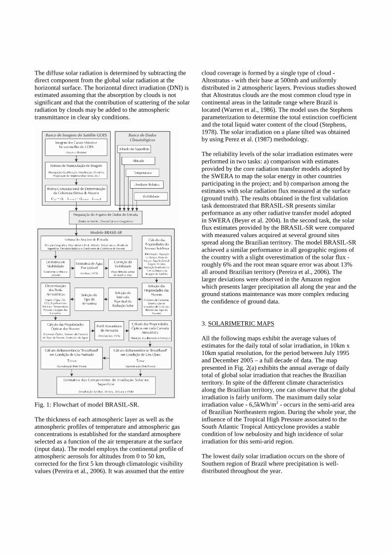
Fig. 1: Flowchart of model BRASIL-SR. The thickness of each atmospheric layer as well as the atmospheric profiles of temperature and atmospheric gas concentrations is established for the standard atmosphere selected as a function of the air temperature at the surface (input data). The model employs the continental profile of atmospheric aerosols for altitudes from 0 to 50 km, corrected for the first 5 km through climatologic visibility values (Pereira et al., 2006). It was assumed that the entire
cloud coverage is formed by a single type of cloud - Altostratus - with their base at 500mb and uniformly distributed in 2 atmospheric layers. Previous studies showed that Altostratus clouds are the most common cloud type in continental areas in the latitude range where Brazil is located (Warren et al., 1986). The model uses the Stephens parameterization to determine the total extinction coefficient and the total liquid water content of the cloud (Stephens, 1978). The solar irradiation on a plane tilted was obtained by using Perez et al. (1987) methodology. The reliability levels of the solar irradiation estimates were performed in two tasks: a) comparison with estimates provided by the core radiation transfer models adopted by the SWERA to map the solar energy in other countries participating in the project; and b) comparison among the estimates with solar radiation flux measured at the surface (ground truth). The results obtained in the first validation task demonstrated that BRASIL-SR presents similar performance as any other radiative transfer model adopted in SWERA (Beyer et al. 2004). In the second task, the solar flux estimates provided by the BRASIL-SR were compared with measured values acquired at several ground sites spread along the Brazilian territory. The model BRASIL-SR achieved a similar performance in all geographic regions of the country with a slight overestimation of the solar flux - roughly 6% and the root mean square error was about 13% all around Brazilian territory (Pereira et al., 2006). The larger deviations were observed in the Amazon region which presents larger precipitation all along the year and the ground stations maintenance was more complex reducing the confidence of ground data. 3. SOLARIMETRIC MAPS All the following maps exhibit the average values of estimates for the daily total of solar irradiation, in 10km x 10km spatial resolution, for the period between July 1995 and December 2005 – a full decade of data. The map presented in Fig. 2(a) exhibits the annual average of daily total of global solar irradiation that reaches the Brazilian territory. In spite of the different climate characteristics along the Brazilian territory, one can observe that the global irradiation is fairly uniform. The maximum daily solar irradiation value - 6,5kWh/m2 - occurs in the semi-arid area of Brazilian Northeastern region. During the whole year, the influence of the Tropical High Pressure associated to the South Atlantic Tropical Anticyclone provides a stable condition of low nebulosity and high incidence of solar irradiation for this semi-arid region. The lowest daily solar irradiation occurs on the shore of Southern region of Brazil where precipitation is well-distributed throughout the year.
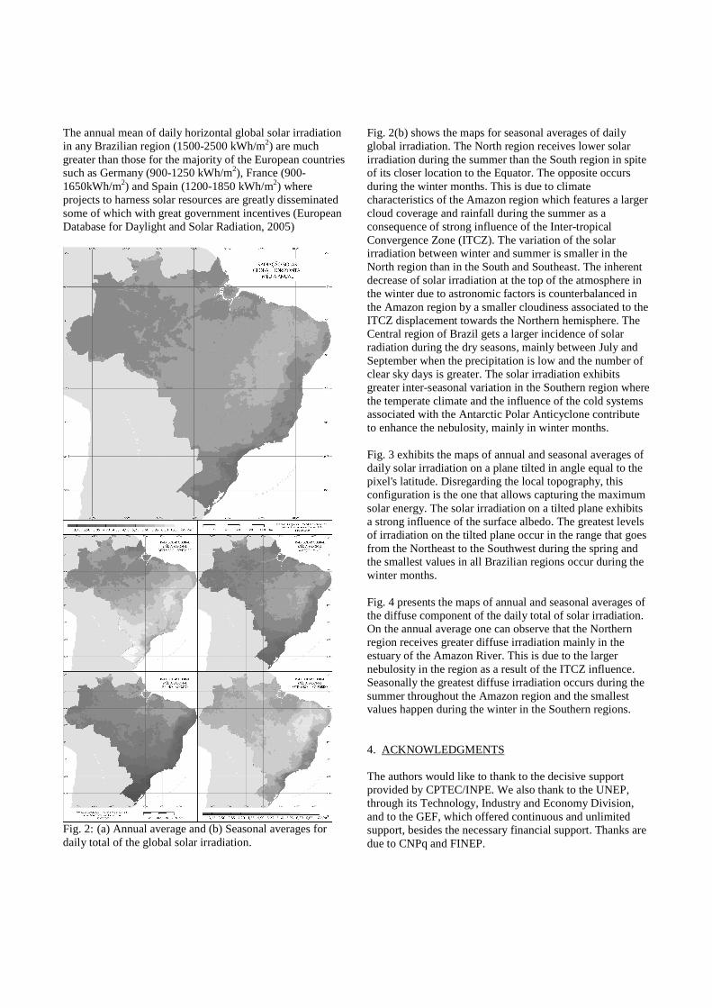
The annual mean of daily horizontal global solar irradiation in any Brazilian region (1500-2500 kWh/m2) are much greater than those for the majority of the European countries such as Germany (900-1250 kWh/m2), France (900-1650kWh/m2) and Spain (1200-1850 kWh/m2) where projects to harness solar resources are greatly disseminated some of which with great government incentives (European Database for Daylight and Solar Radiation, 2005)
Fig. 2: (a) Annual average and (b) Seasonal averages for daily total of the global solar irradiation.
Fig. 2(b) shows the maps for seasonal averages of daily global irradiation. The North region receives lower solar irradiation during the summer than the South region in spite of its closer location to the Equator. The opposite occurs during the winter months. This is due to climate characteristics of the Amazon region which features a larger cloud coverage and rainfall during the summer as a consequence of strong influence of the Inter-tropical Convergence Zone (ITCZ). The variation of the solar irradiation between winter and summer is smaller in the North region than in the South and Southeast. The inherent decrease of solar irradiation at the top of the atmosphere in the winter due to astronomic factors is counterbalanced in the Amazon region by a smaller cloudiness associated to the ITCZ displacement towards the Northern hemisphere. The Central region of Brazil gets a larger incidence of solar radiation during the dry seasons, mainly between July and September when the precipitation is low and the number of clear sky days is greater. The solar irradiation exhibits greater inter-seasonal variation in the Southern region where the temperate climate and the influence of the cold systems associated with the Antarctic Polar Anticyclone contribute to enhance the nebulosity, mainly in winter months. Fig. 3 exhibits the maps of annual and seasonal averages of daily solar irradiation on a plane tilted in angle equal to the pixel's latitude. Disregarding the local topography, this configuration is the one that allows capturing the maximum solar energy. The solar irradiation on a tilted plane exhibits a strong influence of the surface albedo. The greatest levels of irradiation on the tilted plane occur in the range that goes from the Northeast to the Southwest during the spring and the smallest values in all Brazilian regions occur during the winter months. Fig. 4 presents the maps of annual and seasonal averages of the diffuse component of the daily total of solar irradiation. On the annual average one can observe that the Northern region receives greater diffuse irradiation mainly in the estuary of the Amazon River. This is due to the larger nebulosity in the region as a result of the ITCZ influence. Seasonally the greatest diffuse irradiation occurs during the summer throughout the Amazon region and the smallest values happen during the winter in the Southern regions. 4. ACKNOWLEDGMENTS The authors would like to thank to the decisive support provided by CPTEC/INPE. We also thank to the UNEP, through its Technology, Industry and Economy Division, and to the GEF, which offered continuous and unlimited support, besides the necessary financial support. Thanks are due to CNPq and FINEP.
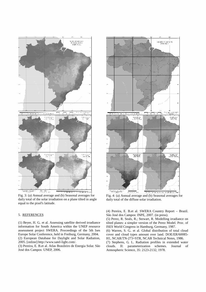
Fig. 3: (a) Annual average and (b) Seasonal averages for daily total of the solar irradiation on a plane tilted in angle equal to the pixel's latitude. 5. REFERENCES (1) Beyer, H. G.. et al. Assessing satellite derived irradiance information for South America within the UNEP resource assessment project SWERA. Proceedings of the 5th Ises Europe Solar Conference, held in Freiburg, Germany, 2004. (2) European Database for Daylight and Solar Radiation, 2005. [online]:http://www.satel-light.com/. (3) Pereira, E. B.et al. Atlas Brasileiro de Energia Solar. São José dos Campos: UNEP, 2006.
Fig. 4: (a) Annual average and (b) Seasonal averages for daily total of the diffuse solar irradiation. (4) Pereira, E. B.et al. SWERA Country Report – Brazil. São José dos Campos: INPE, 2007. (in press). (5) Perez, R. Seals, R.; Stewart, R. Modelling irradiance on tilted planes: a simpler version of the Perez Model. Proc. of ISES World Congress in Hamburg, Germany, 1987. (6) Warren, S. G.. et al. Global distribution of total cloud cover and cloud types amount over land. DOE/ER/60085-H1, NCAR/TN-273+STR, NCAR Technical Notes, 1986. (7) Stephens, G. L. Radiation profiles in extended water clouds. II: parameterization schemes. Journal of Atmospheric Science, 35: 2123-2132, 1978.