BP drilled 3 wells at the Macondo Prospect
19
BP drilled 3 wells at the Macondo Prospect Note to users of the info contained herein. You are welcome to use information here to write your own articles. We have done our best to double check the details but being an independent group compilation there will be occasional mixed up on the latest version. We request that you check with us for the latest updates or correction first before publications. We will update periodically as new info is added. Please send all inquiries to [email protected] 1. Labels and Clarification: Some clarifications are needed to avoid confusion with regard to the explosions, blowouts, sub-sea and sub-seabed (underground) detonations which had been used interchangeably in the past. (?) denote suspected time with margin of error +/-10-20 minutes. With the exception of these times, the macro parts of the giant jigsaw puzzle (aka BP's Gulf disaster) fit like a glove like only the truth can. Time zone when not denoted should refer to local time or CDT which was -5 GMT at the time of incident. 1.1 THWell-Blowout#1 - 21:45 CDT 20 April 2010. – occurred at 3 rd well (Well BE). First gas well blowout from shallow gas influx (<10,000 ft) through leaks in the top hole section of the well caused by replacing drilling mud with sea water at 8,367ft BSL The light hydrocarbon influx came directly from the shallow gas-saturated weak sub-formation (GWSF) zone less than 10,000 ft BSL. After the initial gas surge, the top hole section quickly settled into a steady in-flow state. Light hydrocarbons from the GWSF reservoir continued to flow into the top hole section of the well without affecting the stability of the lower section (bottom hole) of the well. Deep hydrocarbon influx was kept in check by the heavy column of mud weight remaining in the well from 10,000 ft to 18,360 ft BSL. With poor cementing and good vertical hydraulic connections to the shallow GWSF reservoir, hydrocarbons would flow the path of least resistance outside the well rather than into the well at deeper levels at higher mud weight. 1.2 SDWH-Explosions – from 21:49 CDT 20 April - 17:00 CDT 22 April 2010. – occurred at 3 rd well (Well BE). These were surface explosions on board the Deepwater Horizon (DWH) following THWell- Blowout#1. The initial surface explosions on board DWH at 21:49 CDT could have been set off deliberately or accidentally. There were other sporadic explosions witnessed by the fire fighters as DWH went down. We make no conclusions on these observed surface explosions nor any speculation how the first few explosions could have occurred. 1.2a RiserBreak-Explosion - 10:22 CDT 22 April 2010. – occurred at 3 rd well (Well BE). Underwater demolition charges used to break the riser at 460ft from the BOP#1 end; 4540ft below water surface. Total duration of the riser bending from 10:22:56 to 10:23:11 was just 15 seconds, an amazingly short duration to fall from a vertical stationary position. The explosive propulsion can only come from directional charges. 1.3 BSB-Detonation#1 – 17:22 (?) CDT 22 April 2010. – occurred at 3 rd well (Well BE). This was not an accidental explosion but again another deliberate demolition explosion set off within or around the well at sub-seabed level, probably just below the well head (WHD) cemented casings. Its main objective was to demolish the third well and to induce a second bottom hole well blowout – BHWell-Blowout#2. But the unintended consequence of this powerful explosion, tens of metres below the sea floor shook the shallow sub-seabed sediment resulting in a simultaneous massive discharge of hydrocarbons from very recent abnormal hydrocarbon accumulations within structural and stratigraphic traps at the edges of the continental shelf and salt domes. The fault controlled distribution of the first 580 sq miles oil slick captured on the 25 April Satellite photo, suggests that hydrocarbons from the Macondo reservoir might leaking through the myriad of faulted pathways since mid March 2010. Well B reached 13,305 ft BSL and encountered a serious out of well-control situation on 10 March 2010. These pathways were hydraulically connected (directly or indirectly) to Well B which continues to serve as a vertical conduit from the Rigel gas field to the shallow faults. Since these simultaneous massive discharges happened at deep water over a vast expense of water (as far as 30-50 miles NE from the seabed location of the Macondo wells) no one realised the slicks until after 24 April 2010. According to head of EPA, Lisa Jackson, the oil takes more than 4 hours to surface from a depth of 5,000 ft. This means the oil bubbles ascended at a speed of 0.347 ft/s or 0.2 knots. Some coast guards did notice a shallow water gas discharge right on the NW-SE fault line 55 miles away. At a speed of less than 0.33 km/s (speed of sound in air) it would have taken the slow shear waves (assumed 0.2km/s) a few seconds to reach the USCG home base 55 miles away and another few minutes for the gas to reach the sea surface. At 17:44 CDT, more than 20 minutes later, the gas was still bubbling away from the shallow gas accumulation beneath the recent (Quaternary) sediment cover. 1.4 BHWell-Blowout#2 - immediately after 17:22(?) CDT 22 April 2010. – occurred at 3 rd well (Well BE). This is the second well blowout that resulted from the total breach of the base cement plug at the bottom of the well (18,360 ft BSL) shortly after BSB-Detonation#1. Left on its own, the shallow gas from the GSWF zone would have depleted itself at the most after a month. This is the assured outcome of every shallow gas blowout where the oil/gas reservoir had not been breached. Suffice to say, there would have been no mega oil spill if BP just stood by and did nothing. BSB-Detonation#1 confirms the sinister agenda. The BHWell-Blowout#2 started the heavy hydrocarbons (oil) flow from the reservoir, directly into the well. It was the initial explosive hydraulic force that ejected the 40 tons Blowout Preventer out of the 3 rd well, if it wasn't already by BSB-Detonation#1. The original BOP is referred to as BOP#1 to differentiate it from the other two BOPs installed on well A. BOP#2 replaced the broken BOP#1 and is now standing at NASA warehouse facility. No wonder NDV (Det Norske Veritas) were confused in their forensic examination of the fake BOP#2. Although DNV did not exactly say it, even their computer simulations and modeling could not fit in micro-details of BOP#1's failure.
Transcript of BP drilled 3 wells at the Macondo Prospect
BP drilled 3 wells at the Macondo Prospect
Note to users of the info contained herein. You are welcome to use information here to write your own articles. We have done our best to double check the details but being an independent group compilation there will be occasional mixed up on the latest version.
We request that you check with us for the latest updates or correction first before publications. We will update periodically as new info is added. Please send all inquiries to [email protected]
1. Labels and Clarification: Some clarifications are needed to avoid confusion with regard to the explosions, blowouts, sub-sea and sub-seabed (underground) detonations which had been used interchangeably in the past. (?) denote suspected time with margin of error +/-10-20 minutes. With the exception of these times, the macro parts of the giant jigsaw puzzle (aka BP's Gulf disaster) fit like a glove like only the truth can. Time zone when not denoted should refer to local time or CDT which was -5 GMT at the time of incident. 1.1 THWell-Blowout#1 - 21:45 CDT 20 April 2010. – occurred at 3rd well (Well BE). First gas well blowout from shallow gas influx (<10,000 ft) through leaks in the top hole section of the well caused by replacing drilling mud with sea water at 8,367ft BSL The light hydrocarbon influx came directly from the shallow gas-saturated weak sub-formation (GWSF) zone less than 10,000 ft BSL. After the initial gas surge, the top hole section quickly settled into a steady in-flow state. Light hydrocarbons from the GWSF reservoir continued to flow into the top hole section of the well without affecting the stability of the lower section (bottom hole) of the well. Deep hydrocarbon influx was kept in check by the heavy column of mud weight remaining in the well from 10,000 ft to 18,360 ft BSL. With poor cementing and good vertical hydraulic connections to the shallow GWSF reservoir, hydrocarbons would flow the path of least resistance outside the well rather than into the well at deeper levels at higher mud weight.
1.2 SDWH-Explosions – from 21:49 CDT 20 April - 17:00 CDT 22 April 2010. – occurred at 3rd well (Well BE). These were surface explosions on board the Deepwater Horizon (DWH) following THWell- Blowout#1. The initial surface explosions on board DWH at 21:49 CDT could have been set off deliberately or accidentally. There were other sporadic explosions witnessed by the fire fighters as DWH went down. We make no conclusions on these observed surface explosions nor any speculation how the first few explosions could have occurred. 1.2a RiserBreak-Explosion - 10:22 CDT 22 April 2010. – occurred at 3rd well (Well BE). Underwater demolition charges used to break the riser at 460ft from the BOP#1 end; 4540ft below water surface. Total duration of the riser bending from 10:22:56 to 10:23:11 was just 15 seconds, an amazingly short duration to fall from a vertical stationary position. The explosive propulsion can only come from directional charges. 1.3 BSB-Detonation#1 – 17:22 (?) CDT 22 April 2010. – occurred at 3rd well (Well BE). This was not an accidental explosion but again another deliberate demolition explosion set off within or around the well at sub-seabed level, probably just below the well head (WHD) cemented casings. Its main objective was to demolish the third well and to induce a second bottom hole well blowout – BHWell-Blowout#2. But the unintended consequence of this powerful explosion, tens of metres below the sea floor shook the shallow sub-seabed sediment resulting in a simultaneous massive discharge of hydrocarbons from very recent abnormal hydrocarbon accumulations within structural and stratigraphic traps at the edges of the continental shelf and salt domes. The fault controlled distribution of the first 580 sq miles oil slick captured on the 25 April Satellite photo, suggests that hydrocarbons from the Macondo reservoir might leaking through the myriad of faulted pathways since mid March 2010. Well B reached 13,305 ft BSL and encountered a serious out of well-control situation on 10 March 2010. These pathways were hydraulically connected (directly or indirectly) to Well B which continues to serve as a vertical conduit from the Rigel gas field to the shallow faults. Since these simultaneous massive discharges happened at deep water over a vast expense of water (as far as 30-50 miles NE from the seabed location of the Macondo wells) no one realised the slicks until after 24 April 2010. According to head of EPA, Lisa Jackson, the oil takes more than 4 hours to surface from a depth of 5,000 ft. This means the oil bubbles ascended at a speed of 0.347 ft/s or 0.2 knots. Some coast guards did notice a shallow water gas discharge right on the NW-SE fault line 55 miles away. At a speed of less than 0.33 km/s (speed of sound in air) it would have taken the slow shear waves (assumed 0.2km/s) a few seconds to reach the USCG home base 55 miles away and another few minutes for the gas to reach the sea surface. At 17:44 CDT, more than 20 minutes later, the gas was still bubbling away from the shallow gas accumulation beneath the recent (Quaternary) sediment cover. 1.4 BHWell-Blowout#2 - immediately after 17:22(?) CDT 22 April 2010. – occurred at 3rd well (Well BE). This is the second well blowout that resulted from the total breach of the base cement plug at the bottom of the well (18,360 ft BSL) shortly after BSB-Detonation#1. Left on its own, the shallow gas from the GSWF zone would have depleted itself at the most after a month. This is the assured outcome of every shallow gas blowout where the oil/gas reservoir had not been breached. Suffice to say, there would have been no mega oil spill if BP just stood by and did nothing. BSB-Detonation#1 confirms the sinister agenda.
The BHWell-Blowout#2 started the heavy hydrocarbons (oil) flow from the reservoir, directly into the well. It was the initial explosive hydraulic force that ejected the 40 tons Blowout Preventer out of the 3rd well, if it wasn't already by BSB-Detonation#1. The original BOP is referred to as BOP#1 to differentiate it from the other two BOPs installed on well A. BOP#2 replaced the broken BOP#1 and is now standing at NASA warehouse facility. No wonder NDV (Det Norske Veritas) were confused in their forensic examination of the fake BOP#2. Although DNV did not exactly say it, even their computer simulations and modeling could not fit in micro-details of BOP#1's failure.
The Gulf was only flooded with massive amount of oil (confirmed by the satellite photo taken on 25 April 2010) after BSB-Detonation#1 and BHWell-Blowout#2. Earlier satellite photos before this two events showed only the smoke plume from the burning DWH. 1.4a How the top hole well blowout occurred? When the pressure within the well is lower than the outside formation pressure, gas if present, can enter the well through the open well bore (during drilling) or through leaks in the well on completion. The pressure within the well increases with depth due the weight of the drilling mud (quoted by their densities) plus whatever fluid above any depth point in the well. By standard practice, the top hole section had to be sealed tight to prevent hydraulic connection to the seabed, before proceeding to lower depths. In the Macondo case, BP was grossly negligent on this safety aspect. The evidence are all over the seafloor. The only way thick layers of cement and drilling mud can cover the surface of the seafloor is through abnormally massive circulation losses, not into the formation but upwards to the seabed. The observed “bladder effects” and abnormal negative pressure tests can be easily explained by the hydraulic connection between the GWSF (gas saturated weak sub formation) zone, top hole leaks in the well and the water column. (details in another series of articles)
The ECD (effective / equivalent circulation density) is always calculated to counter the expected formation pressure at the bottom hole section as the drilling progresses. This makes sense since formation pressure generally increases but not always. Geohazards surveys are conducted to detect abnormally pressurised zones because of this. BP apparently skipped this site specific geohazards investigation (another drilling risk aversion violation). Their drilling safety assessment was primarily based on 3D exploration seismic data which specifically focused on deep reservoir assessment and not the hazardous shallow zone (within the top hole section) which would be blind to any interpretation carried out using 3D deep seismic sections. It is akin to a long-sighted person reading a book without correction glasses. It is estimated that GWSF hazards occur in about 20% of all drilling locations. When drilling mud is replaced by seawater within the top hole section, the well pressure in the top hole section will drop by a relatively larger percentage compared to the bottom hole. If there is no GWSF hazards and the well is 100% sealed from top to bottom, there will be no gas influx at any level until the well pressure at the well bottom is significantly lower than the reservoir pressure. The volume of seawater required to displace the drilling mud before the breaking stress limit of the base cement plug is reached, can be accurately calculated by the well cement specialists assigned for the job. This is where the bad cement job by Halliburton is a significant factor. Few noticed (at least publicly) that the seawater replacement procedure was not yet completed before the first blowout occurred on 20 April. Either Halliburton miscalculated or the gas influx came from an unexpectedly shallower source like the GWSF. Was this shallow gas problem to be expected? Of course given the poor cement job from the very start, abnormally high loss of drilling fluid and stuck drill-strings (2 out of 3). But the most telling had been the numerous gas-related out-of-well-control situations. Inside the well, as the lighter gas bubbles rise the volume expands inversely proportional with the drop in pressure. Because gas is compressible, a shallow gas well blowout can never blow off the BOP even if the BOP is shut tight without bleed off. An oil well blowout is different because oil is incompressible. But BP said the BOP failed to shut and was freely flowing and feeding the rig fire. So even a second oil well blowout (on 22 April) could never blow off the wellhead if the BOP was never shut and the well freely flowing. BSB-Detonation#1 served 3 purposes. The first is to jam up the potential flow. Evidence: The jammed up 2 drill-pipes at the kink in the bent riser. It also weakened the well casing cement at the annulus. That is why the detonation had to be below the well casing level. The shock waves would also breach the base cement plug to unleashed the explosive hydraulic power of the reservoir. 1.5 RWell-Detonation#2 – 11:22(?) CDT 1 Aug 2010. – occurred at Relief Well C intersect with 3rd well (Well BE) 18000ft BSL. This was probably the last desperate effort (having to resort to using a nuclear device) to seal the gushing well after repeated failures in July using conventional means. As the generated shear waves radiated (at around 0.2 km/s) from the source point, they would trigger the release pent-up stresses in the shallow crustal zone. It was no coincidence a rare shallow quake occurred in Louisiana at 11:34:29 CDT (12 minutes later) on 1 Aug 2010. The epi-centre was 5 km deep on the NW-SE fault line 215 miles from the Macondo well. Given their penchant for certain easy to remember numbers, it would not be a surprise if the time 11:22 CDT was chosen as the designated detonation time. The more destructive shear waves would have reached the epicentre in less than 0.5 seconds. There is no better correlation than that. If that powerful detonation could trigger an earthquake at the stressed-up junction zone between the New Madrid and the NW-SE fault line, it would have ejected the wellhead at well A if the device was indeed detonated at that well. The fact that the wellhead at well A remained standing is another proof well A was not the rogue well Relief Well C intercepted. The oil-gushing well Relief Well C was trying to kill at 18,000 ft BSL was not well A but a 3rd well labelled as Well BE (mistakenly labeled in an early Rov video on 22 April 2010 before BSB-Detonation#1).
It is not a coincidence after that 1 Aug 2010 (Rwell-Detonation#2) there were increased ground activities in covering up or grouting the massive blow holes, gas vents and columns of oil discharges along long lines of fissures on the sea floor, some as long as a few km. After steadily leaking oil from the Macondo reservoir for 100 days, there would be no reason for this second round of sudden eruptions of gas and oil from the deep. The first round of massive oil/gas discharges from shallow abnormal accumulations occurred seconds after BSB-Detonation#1 on 22 April. The second and more powerful detonation at 18,000 ft BSL directly affected the deep rock formation and aggravated the faulted pathways leaking hydrocarbons from the reservoir. It is logical for such a powerful blast to have forced hydrocarbons which had earlier migrated and accumulated at traps above the blast depth, to the seafloor resulting in the
numerous blow holes, vents and columns. The scale of this second wave of hydrocarbon discharges certainly exceeded the massive oil spill seen on 23 April. The satellite photos would probably pass unnoticed, being masked by the earlier continuous spill unlike the satellite shot on 25 April 2010. While that nuclear detonation at depth, did not eject the wellheads off well A and B, there were considerable damages to the fragile geology and seafloor. BP had to intensify their recovery efforts by urgently grouting of the seafloor. The priority grouting was around well A due to the horrifying images of the seafloor cracking up and emitting huge bubbles of oil and gases. A nuclear detonation on 1 Aug would be the only logical answer to a new round of oil emanating from such a large area (est. > 10 sq miles) of the seafloor. After 101 days (since 22 April) of continuous oil gush, the Macondo reservoir pressure would have been depleted by one fifth. By conservative estimates, it would have leaked out 10.1 million barrels of oil (at 100,000 bbl/day). Forbes estimated Macondo's recoverable reserves to be 50 million barrels at the minimum. 1.6 Tar mats and sub seabed oil. (to be filled in later) 1.7 Some more confusing terms from different specialisation. Following terms are adopted (and continually updated) for those interested in writing their articles based on the explanations given here. Bear in mind this is an ongoing community compilation which is being updated continuously in the technical group. Please look for the most updated version. Blowout - A general term referred to any uncontrolled flow of gas, oil, or other fluids into the atmosphere, water column or into an underground formation. There is no distinction on the source of the blowout fluid. Well blowout - this specifically refers to a blowout in an oil well. There is normally no blown well crater since the fluid would be ejected out at the top opening of the drill-string at the drilling rig. The most common type of well blowout is the shallow gas blowout. Shallow gas blowout – any blowout caused by shallow gas (any accumulations or reservoir within the first 5,000 ft of the seabed). If it occurs in within a well, it would be better to term it as gas well blowout but the common usage is just gas blowout. You can have a gas blowout outside a well. To prevent confusion, we now use the term blow hole. Oil Well blowout - the fluid is mainly heavy hydrocarbon or oil. Blowout crater - this normally refers to any crater caused by a blowout. Blown well crater - This specifically refers to the crater left behind after the wellhead is blown off the well. Blow hole - in the normal sense same as blowout craters but happens outside the well. Instead of a well, the pressure builds up in a cavity / highly permeable fault or fracture zone / large gas pockets / structural traps, until it exceed the overburden or confining pressure. In very soft unconsolidated clayey sediment, pockmarks (circular depressions) are very common. As soon as the fluid pressure exceeds the confining pressure, fluid expulsion occurs resulting in the pockmark or circular depression. For the deeper blow holes which are more voluminous and higher pressure, the situation is more complex. Before the accumulating fluid pressure can even approach the limiting confining pressure, the weakest link in the sediment structure will leak first; forming fluid seeps or larger volume columnar discharge (gas/oil columns). Seeps can be periodic or continuous streaming bubbles. The trailing bubbles generally follow the prevailing under sea current. Thus, for a blow hole to occur, there must be a sudden increase in pressure (as in the sudden release of hydrocarbons from the reservoir) or a sudden decrease in the overburden/confining pressure or a combination of both. BSB-Detonation#1, BHWell-Blowout#2, RWell-Detonation#2 and Japan 9.0 Quake are some examples. Gas columns rise vertically above the seabed. The height of the column above the seabed provides an idea of the overpressure in the gas supply. Natural oil columns are very rare since there need to be a very permeable conduit (like a well) to provide the continuous oil supply. A second smaller oil blow hole (can be seen in videos at oilspillhub.org) spewing black oil plumes escape attention. This blow hole probably lies on a shallow fault which intercepted the 3rd well at shallow depth. Gas vents - more general term used when the limited Rov viewport cannot not see the extend of the column, seabed craters and other characteristics, only the upwelling of the particles in the water column. Top Hole - top section of the well normally above formation level, before the mud logs begins. BOP - blow out preventer. BOP#1 refers to the first BOP that was blown off the wellhead at well BE. BOP#2 refers to the 2nd BOP brought in later to masquerade as the original BOP at well A. BOP#2 was removed on 3 Sept 2010 for forensic examination at NASA facility. BOP#3 replaced BOP#2 upon its removal until 5 Nov 2010.
1.8 Evidence of extensive oil seeps on the seafloor over tens of miles from the Macondo wells A single gas well blowout as evident from tens of blowouts throughout the Gulf does not cause such extensive damage as the BP’s Gulf Blowout disaster. The many out-of-well control situations reported in the 3 wells before 20 April 2010, can be considered as gas well blowouts that had been brought under control. There was evidently no massive oil or gas spill from cracks on the seafloor beyond the 1 mile radius that caused visible oil slicks before the blowout incident on 20 April 2010. Besides the few spots of oil slicks several miles from DWH (reported by the USCG), there was no oil emanating from the seafloor surrounding the wellhead or BOP until the evening (before 1700 CDT) of 22 April 2010 (video evidence). In the hundreds of blowouts in wells around the world, less than 10% escalated into disastrous rig fire and explosions. All blowouts do not cause oil and gas to spill out of the seafloor for tens of miles away from the well. Gas (mainly) spewing out of fault fractures within 1 mile is common but rarely extends beyond 2 miles from the blowing well. The reasons for this are fundamental geophysics. Then suddenly on 24 April 2010, hundreds of square miles of oil slick were reported. The satellite photo on 25 April showed approximately 580 sq. miles of oil slick, much of it stretching to the north, north-east and east of the Macondo wells (which was actually at the south-western edge of the slick pattern. There are several obvious conclusions to the drawn here. 1.8.1 The Macondo wells (possibly all three of them) cannot be the only source of such a large area of massive oil leak. 1.8.2 The Macondo wells were not even the main source of the massive oil leak. There is no natural geological process to transfer all
that oil from the reservoir 18300ft below sea level all within a day. 1.8.3 Let’s discount BP’s official version of oil freely flowing from the reservoir on day 1. The oil actually started spewing from 17:22
CDT on 23 April, and by 25 April (assuming the satellite photo was acquired at 17:22 CDT) the max days is 3.
1.8.4 At the standard 1 micron thickness (used by oil companies to grossly underestimate the volume of oil spilled), the volume of oil spilled works out to be 9,450 barrels. But we know this cannot be true. How? Let’s work backwards.
1.8.5 A total of 9,450 barrels for 3 days’ spill = 3,150 bpd. That was how BP came up with the 5,000 bpd estimates after the 1,000 bpd and then 2,000 bpd estimates.
1.8.6 On 30 April 2010 the total spread area of slick was 3,850 sq. miles (10,000 sq km). That another 5 days from 25 April. 1.8.7 5 x 3,150 = 15,750 + 9,450 = 25,200 barrels at the most. At 1 micron thickness 3,850 sq miles would need 62,729 barrels of oil
or 37,528 barrels short. 1.8.8 The slick pattern analysis does not indicate a continuous flow of oil from a single source but periodic massive discharges from
seafloor cracks. 1.8.9 To be continued 2. Times Line & Logic of Drilling Operation (3rd party comments by a driller based on corrected BP time-line) This is not the detailed time line but an itemised summary of the key events. 2.1 Going by official records, 109 days is an extremely long period to drill one well. Most exploration wells are completed within a month including testing. For exploratory wells, you move on after 30 days or at the most 50 days due to a very problematic well. If it was a problematic well, you do not drill the next exploratory well less than a km from it. At a conservative drilling rate of 600 ft/day and 80% of the 109 days used for drilling progress, BP would have drilled at total length of 52,320 ft. The combined total drill depth of well A, Well B and Well BE = (5,000 + 8,305 + 13,360) = 26,665 ft. This is still 50% of 52,320 ft. With that amount of time, BP could have drilled 4 wells each 13,000 ft. bml. Drilling 3 wells as claimed by BK is not that far fetched. In fact the reverse is true. 2.2 With the initial reported shallow gas problems, it would be unlikely for BP to have a successful re-entry at well A which had been left unattended and unplugged for more than 3 months. It is thus not surprising for BP to encounter enormous gas problems on reentry which would have forced BP to abandon well or risk a gas blowout. Once the integrity of the seafloor around the wellhead is compromised, it would be logical to abandon the well for economic and safety reasons. Again no one can disagree with BK who is a known expert on the seafloor zone. 2.3 Well A had to be abandoned after more than 3,000/3,500 ft of drill string (drilling pipes) was cut. The drill-string was stuck after the open bore section (4000 – 5000 ft bml) collapsed into the well. According to the time line received, 16 Feb 2010 would be the likely date well A was abandoned. The well records would have shown operation time spent on attempting to recover and subsequently cutting the drill-string. If this is proven, then BP could not have continued drilling at well A, not with more than 3,000 ft of drill-pipes inside the well. This is the conclusive proof that well A was abandoned and did not continue down to the reservoir. Without the benefit of the drilling operation records, it appears that BK might be right on this account as well. His argument as follows:
During the recovery of BOP at well A in September 2010, it was reported that 3,000 / 3,500 ft of drill-pipes could be hanging from the BOP. We were amazed how BP could have known this before hand. The Rov video showed the recovery of a pipe

much shorter than that, probably less than 30 ft. The amazement was the expectation of a long pipe hanging from the BOP and the length of it. According to BP's report (p 82 of 192), “To temporarily abandon this well, mud had to be removed to a depth of 8,367ft and replaced with sea water.........” The hanging pipe must have been this length of drill pipe (8,367 ft less 5000 ft = 3,367 ft). To account for the abnormal “2 pipes in the riser” observation, BP reported that the drifting DWH must have pulled (lifted) the drill-pipe with respect to the BOP and riser (p 165 of 192), later broke and slid back into the BOP. Now if that was possible (despite the physics of impossibility) it would mean the BSR no longer had any tight grip on the drill pipe. Given the weight of >3000 ft of drill-pipe hanging on it, would the whole drill-string not drop to the bottom of the well? Which then means no hanging drill pipe of whatever length. Then why would BP suddenly announce the possibility of 3,000/3,500 ft of drill-pipe hanging from the BOP on the eve of removing the BOP for CSI investigation? It suddenly dawned on them that someone in the investigation team might want to send a probe into well A. A surprised discovery of the cut drill-string sticking out of a well (13,360 ft deep) would put BP in an impossible position to continue with the lie. How could 3,000/3,500 ft of drill-pipe be hanging in a well which had been freely flowing hydrocarbon for 87 days? It would prove that well A was indeed drilled to 5,000 ft and collapsed in at 4,000 ft or less from a high pressured fluid-saturated sand. To preempt this, BP announced the possibility of a hanging drill string first, forgetting what had been spun in their own report (it is difficult to cover a lie with many lies as they will soon trip over each other). If BP did not preempt a possible shock discovery of a “very long long drill pipe in the well” the field crew at site could run wild with the truth. Like previous “jump the gun” statements, this was design to keep the innocent crews in line and prevent the truth from escalating. The crew on the ground were already speculating on the truth exposed by various parties especially Matt Simmons and us. BP's official fabrication allowed them the excuse to keep their mouth shut in order to continue working for any oil company. As Simmons said, “...these are smart guys.” They know the truth but they love the money more. The well kill on well A was just a charade. The third well 720 ft NW of well A, was the one gushing and flooding the Gulf with massive oil. If the charade of well killing at well A is so obvious, why did the tens of crew at site who must have known, not tell? The combined effect of “carrot and stick”, oil corruption, the threat of being killed like the late Matts Simmons, the lack of conscience, the chance to milk from a disaster and the “better speak no evil” attitude, all make wilful blindness the preferred option for many in the industry.
2.4 BP applied for a by-pass but a side track at that shallow depth from the same seabed location would be the same as in 2.2. Besides it would have been more expensive than a simple vertical well. A deviated trajectory would be more hazardous with regard to drilling risks in the presence of shallow gas hazards. It appears that BP cheated MMS on this as well. 2.5 Logically BP would have taken the easier way out by drilling at the already approved well B location. By most accounts, BP did drill at well B. It is not clear why BP did not notify MMS on drilling Well B and even denied them officially after the explosion. They had legitimate clearance to drill well B. All they needed was a notification. It is giving us, the drillers a very bad reputation. Why deny the obvious even when BP had every right to drill well B? Something is very wrong here. We can see no practical benefit for denying well B when there are evidence for it. Unless admitting to well B would lead to the high probability of drilling the 3rd well since well B was widely known to have stopped at 13,305 ft on 11 March 2010. 2.6 Again the site drilling records would prove that BP drilled another well from 16 Feb to 15 March 2010. Assuming BP did continue drilling at well A. The total length drilled would have been (8,305 – 5,000) a measly 3,305 ft giving an absurdly low drilling progress of 122 ft/day. Alternatively, at a completely new hole 8,305ft. would give a progress rate of 307ft/day or about 50% of the normal rate. This would be more consistent with the crew's account of BP pushing for and getting a faster drilling progress.
2.7 In the Waxman Congressional Investigation, there were emails to show that BP asked for MMS's permission to use a cement plug 750 ft above the bottom of the hole on March 11, 2010. Normal requirement was 500 ft but because of the gas stringers and near-blowout situation, BP could only manage 750 ft above the problem interval.
On March 10, BP executive and regulatory adviser Scherie Douglas e-mailed Frank Patton, the MMS' drilling engineer for
the New Orleans district, telling him: “We’re in the midst of a well control situation on MC 252 #001 and have stuck pipe. We are bringing out equipment to begin operations to sever the drill-pipe, plug-back the well and bypass," Per Dr. Robert Bea, engineering professor at the University of California, Berkeley, who has consulted with the Interior Department on offshore drilling safety, this incident was a "showstopper... They damn near blew up the rig.”
The above recorded incidences meant that BP had to abandon the second well (well B) too. BP lost 1,159 ft of drill string (13,305 –
12,146). It would have been an impossible situation if they were actually drilling at well A. A patch up top hole section and a problem bottom hole would be like having your bottom and head burning at the same time. We would vote unanimously that this was a completely different hole (well B) and not well A.
2..8 On record BP applied for by-pass but the final well diagram shows a straight vertical well. From a drilling perspective, a by-pass would be more problematical than a vertical well. A by-pass well would have encountered the same near blowout situation as on 10-11 March 2010, a few days later when the by-pass reached the same gas stringers since they are part of the geological formation.
2.9 Again the site drilling records would prove that BP drilled another well from 16 March till 20 April 2010. Assuming BP did continue
drilling at well B. The total length drilled would have been (13,360- 8,305) or another 5,060 ft. At 30 days it would mean a low drilling progress of 170 ft /day. Alternatively, at a new hole 13,360 ft would give a reasonable drilling rate of 445 ft/day.
2.10 An electronic copy of the application for spudding a new location. The well request (API well number 608174116901) was dated
15 April and approved on the same day. The Req. Spud date was 16 March 2010. The spud date would have been 3rd February 2010 if this request was not for a new well location. Meaning this request on 15 April 2010 (5 days before the blowout) cannot be well A.
3. Oversights / Mistakes in the cover-up of the 3rd well (well BE). Some of the honest mistakes made, do point to the truth being covered up. Guilty conscience can sometimes jump the gun. It is impossible to cover such a big lie except by willful blindness. 3.1 Alleged drifting of the burning DWH by 714 ft NW of well A. BP made this “drifting” report within the first 12 hours of the blowout when the sea was flat calm. In the video accounts and USCG transcripts, experts kept stressing that the floating MODU was held in place (at the drilling location) by the riser. Which was the same point asserted by BK in his articles since August 2010. Why would BP make such a false report on 21 April 2010 when it was physically impossible for the rig to have drifted by 714 ft? At least not until the riser was broken at 1022 CDT 22 April 2010. If BP had kept quiet on the new location of the 3rd well, perhaps the mistake would not be so obvious. For what reasons did they jump the gun? BK had detailed out many reasons previously though not all are agreeable to us. Perhaps in August 2010, the “planned objective” was not very clear yet. We now think the most important reason is as follows:
The most important reason why BP jumped the gun was the fact that some of the crew knew they were on a different location after the “accident”. They might be called to testify. If by some “accident” the difference in the well location (coordinates) happened to surface, it would open a can of worms. BP would be at a loss to explain. The drift theory then in the hearing would be an after thought. So it was better to declare a “weak possibility” prior to its discovery rather than later and hoped that no one noticed. They did not anticipate a BK to enter the scene or to risk his life in pointing out the many discrepancies.
3.2 The odds for the “riser to fall 5000 ft, break and form an oil gushing crater” at exactly the same spot “the burning DWH drifted to in calm weather” must be at least 1 trillion to 1. The truth? The crater was in fact the blown 3rd well and the “3 leaks on the riser – crater” story, a fabrication based on distorted truths. Notice that there is always 3 in the story, “3 leaks, 3 wells, 3 BOPs, 3 drilling rigs (DD2, DD3 & DE), etc”. For a fabrication to appear credible, it has to be close to the truth. There were definitely 2 blown craters spewing oil plumes. BP could very well use 5 leaks, 2 rigs or 4 BOPs but the 3 wells would stick out like a sore thumb. If everything else is in three's, then perhaps the truth of the 3 wells would not be so obvious. With overwhelming evidence of the 3rd well, it is willful blindness not blind justice that continues to deny the true existence of 3 wells at the Macondo prospect. 3.3 For more elaborate explanation on the 3 leaks in the riser story refer to The Farcical 3 Leaks On The Broken Riser Story. To summarize, there are simply too many flaws in the “3 leaks on the riser” story which did not stand up to scrutiny. Why should there be so many serious flaws (>30)? The reason is simple. The degree of difficulty, inconsistencies and flaws increases for each well. It is impossible to make up a consistent story to cover 3 wells. 3.4 The first leak shown on the Rov video on 23 April (relabeled as 3rd leak) was an open ended naked drill pipe sticking vertically out of the crater. Looking at the other pieces of riser on the seabed (as field calibration) it would again be physically impossible for the 5½ drill-pipe to break independently of the encasing 21 riser pipe at mid water, discard the encasing 21 riser pipe to stand naked on the seafloor. It is also impossible to explain how the broken drill-pipe at mid-section to be leaking gas. The riser pipe from the source well can have only one open end, not 2 open ended pipes of different dimension (one 5½ inch and another at least 3 times larger in diameter). Thus the only way this could happen is at the blown well itself. These naked drill-pipes were inside the well and not inside the marine riser at the water column when BHWell-Blowout#2 occurred. The naked drill pipes were ejected out of the well by the same explosive hydraulic power which ejected BOP#1. The naked drill-pipe with gas/oil spewing from it, is the irrevocable proof that the “riser-crater” aka Leak#2 was the 3rd well after the second blowout BHWell-Blowout#2. 3.5 Why would BP show the secondary leak first (Leak#2 = “riser-crater” plume) and not the primary source (Leak#1 at well A) until 20 days later? BP had not been able to answer this intriguing question because the answer would implicate BP of the 3rd well. They needed the 20 days to set up another BOP (BOP#2) and reattached the broken riser at well A. The original BOP (BOP#1) was blown to pieces and lay scattered on the seafloor. For this to happen, the 3rd well had to be blown open like a crater because the cemented seafloor was much weaker than the steel BOP. 3.6 The Rov videos up to 11am 22 April 2010, show no leaks on BOP#1 at the 3rd well. The doctored Rov videos until late April showed no oil or gas emanating from BOP#1 or the seafloor surrounding BOP#1. Then 20 days later, the Rov videos show oil/gas
gushing at the kink on top of a new BOP (BOP#2) at an estimated rate of 20,000 to 70,000 barrels /day. This is an outrageous discrepancy which cannot be explained by a single well. How did a dormant well suddenly become an active gushing well 20 days later without an earth shattering event? There is no logical explanation unless that earth shattering event was a detonation within the 3rd well on the evening of 22 April 2010 (BSB-Detonation#1) which completely blew the 3rd well wide open as Matts Simmons had repeatedly asserted. BK cited several reasons why BSB-Detonation#1 had to happen within that narrow window of opportunity. See 1.3 3.7 BP had to broadcast the Rov videos under congressional pressure. BP also saw this as an opportunity to deceive the public en-mass. They thought it would be a simple matter of substituting the coordinates of well A onto the raw Rov video of BOP#1 at the 3rd well and the public would sheepishly believe BP's fabricated 1 well story. Unfortunately, there were insiders with conscience. While they could not speak, they could make “mistakes”. They had hoped some good Samaritans among the 6 billions inhabitants of this planet would pick up the discrepancies. Thus, you have Rov videos showing the same “spewing oil riser-crater” with their true coordinates (exactly as the drifted location 714 ft NW of Well A) and absurd coordinates hundreds / thousands of feet away. It is as plain as saying “look at this oil spewing crater, it is the 3rd well”. 3.8 The 3rd well was mistakenly (or intentionally) labelled as “Well BE” and “Well” before BSB-Detonation#1. In all subsequent ROV videos, the well A was always referred to as Macondo well #1, MC252-1 or simply well A. Well B was also labeled as “Well A”. The first 2 days of Rov operation were probably disorganized. Were the labels embedded? The truth can easily be proven with a congressional order to reveal the raw videos,. 3.9 Simple physics will show that a break in the riser with oil flowing does not make a symmetrically round deep crater. The only way to get an instant “blowout crater” as the name implies is through a forceful blow-out. The later videos showed that the crater had been excavated wider to give a gentler sloping depression. It showed that BP realised their mistake and tried to make amends, hoping no one noticed. Sorry, many of us did.
3.10 Again if the oil was really gushing through the “riser from well A” the simple solution would be to cut off the oil supply. BP did that but only some 40 days later (1 June 2010) after they had exhausted their silly junk shot games. Even then BP allowed the gas (less oil) to continue gushing for another 87 days before closing the cap. Why? Not because it could not be done earlier but because it would look silly if well A was shut tight and the sea was still flooded with new oil from the openly gushing 3rd well. It was such a shallow deception. Yet the whole government and industry swallowed it. No, as Simmons (and he should know) said, “they were not stupid”. They just went along. A high oil price fueled by fear of diminishing supply or disaster is good for them. More Oil Money. 3.11 So why did some of the Rov videos show glimpses of the wellheads at well A, well B and well BE (well no 3)? A mistake by some Rov operators or was it intentional? Intentional so that they could identify the insiders who squealed since only those inside the industry could tell the difference between one wellhead from the other. 3.12 Video evidence of BP extracting the casing from the 3rd well on 29 July 2010. Again the incriminating video was embedded in between the non-incriminating ones. This is a rare find. Copies had been downloaded and distributed. If you have not done so please contact Amin on his personal channel. 3.13 Three different BOPs (or parts of them). There were some videos showing removal of sections of the first BOP (BOP#1) near the 3rd well. That video showed a 13-day operation from 3 to 16 July 2010 while the world was still mesmerized with the oil/gas gushing out of the fake BOP#2 at well A. At the same time BP misled the world on the danger of premature removal of the BOP. Even shutting the “bogus” cap on well A was intensely debated for days before it was finally shut on 15 July. This is another clear proof of the 3rd well and 2 BOPs in play. If there was only one well and the BOP was still intact, what the hell were the crew doing with another broken BOP in the first half of July just 700 ft away from well A? In truth nothing they did on well A could adversely affect the leaking Macondo Reservoir 18,000 ft BSL. Well A was drilled to only a depth of 5,000 ft BML; 8,000 ft short. 3.14 As a final proof that BP drilled 3 wells, verify them at site. First locate the wellhead for Well A. Using the same positioning system and setup (this is to prevent adulteration of the coordinates) move 300 ft west to locate the wellhead at well B. Once the wellhead at well B is located move north by 800 ft to the approximate location of well BE (well#3). The blowout crater was already excavated into a shallow wide depression and the well itself marked by a rectangular steel reinforced cement plug. There is no reason to construct such a structure on the seabed except to plug an open well which has lost its wellhead. The survey of the wellheads must be carried out using AUV- mounted multibeam echo sounder (MBES) in addition to the pinger and side scan sonar equipment. You can easily cheat with one tool (Rov -video) but you cannot cheat with a 3-tool deployment. That is why 3-tool or 4-tool deployment is the standard industrial practice, not just Rov-video. There is a possibility that once this article is published and the information is out there, BP might remove the wellhead at well B and the cement plug at the 3rd well. It was for this reason this compilation was kept secret and never published. Now that the secret of the 3rd well is out, there is no reason to keep this secret any longer. The only way BP can remove the wellhead at well B and the cement plug at well BE is by explosive demolition. If the demolition is powerful enough, it should trigger a massive discharge of oil and gas into the Gulf water similar to the oil slick reported in late March 2011 following Japan's 311 quake-tsunami. After the demolition, well B and
well BE would be just blown well craters with hydrocarbon plumes. Whether BP would want to have another round of oil and blood on their hands is entirely up to their conscience. Whether the world would just stand by nonchalantly while BP commit murders is up to the world's collective conscience. ~~~ Some draft notes of interest for background understanding …NOT TO BE COPIED for posting without permission ~~~ being drafted for legal filing Since February 2010 and continuing now through the close of 2011, we have witnessed at least a five-fold average yearly increase in
the numbers of beached dead dolphin and sea turtles, decimation and disease of oyster, shrimp and other fisheries, poisoning and
death of vegetation in coastal wetlands, deaths and illness to hundreds of oil workers, volunteers, and residents, and economic ruin for
Gulf seafood and tourism industries. In an effort to understand what really happened and its ramifications, we have tried to make
sense of the facts, videos, and descriptions made available to the public by BP, Transocean, the US Coast Guard, and our
government. That study at first turned up more questions than answers, but slowly facts have led to a plausible, consistent, and
compelling description of events and actions that occurred leading up to and following the April 2010 sinking of the Deepwater Horizon
platform in the Gulf of Mexico (GOM). This description, offered herein, is deduced entirely from verifiable facts provided here as
evidence. In view of the deliberate or negligent criminal nature of some of these actions and their extremely deleterious ramifications
for the safety of the marine life, coastal ecosystems, and human communities affected, we are asking the Courts to demand full and
truthful explanations of the facts and to hold the appropriate persons or entities responsible for these criminal actions.
We assert that various representatives of BP, Transocean, the US Coast Guard, state and federal agencies (including what then was
called the Mineral Management Services), and other persons or entities to be determined, are guilty of the wrongful acts listed in
Section 1. We offer supporting descriptions, timelines, documents, official footage, and other evidence for these arguments in Section
2. Additional references for supporting information are provided in Section 3.
Section 1. We allege that BP and other persons or entities whose identities are to be determined are guilty of the following wrongful acts:
a. Illegal drilling of a third well at a third distinct seabed location approximately 720 ft northwest of Well A (MC252_A on BP's permit application to MMS) and 800 ft north of Well B (MC252_B on same permit application). This third well at a new seabed location was not approved by the Mineral Management Service (MMS) for exploration drilling in the Macondo Prospect of the GOM and does not qualify as a bypass from Well A or from Well B. The seabed locations of Wells A and B are the only ones which BP specifically applied for and received approval from the MMS for drilling. (Exhibit 1) Based on ROV video footage and other evidence provided in Section 2 (Exhibits 2,3,4), we posit that this third undisclosed well, referred to as "well BE" in the ROV video evidence, was the only one of the three vertical wells to have reached BP’s target depth (TD) of 18,360 ft below sea level (bsl). Hence it was the only well deep enough to have reached the Macondo Reservoir and thence to have suffered the disastrous gas blowout which set the Deepwater Horizon (DWH) rig on fire on 2010 April 20 at approximately 2200 CDT according to the media-publicized recorded sequence of events. b. Perjury before Congress by giving false evidence that BP had drilled only one well (well A); thus implying the gas blowout on 2010 April 20 had occurred at well A when in truth the blowout had happened at the third well (well BE). Based on Exhibits 2.5 and 5, we posit that well A was drilled to a depth of only 5,000 ft (±50 ft) bml, and that it could not be drilled deeper because its drill-string was jammed by a high-pressured formation collapse at the open section of the well bore. The high-pressured cave-in that jammed the drill-string at this shallow depth was likely caused by geohazards such as a gas-saturated weak sub-formation (GWSF) zone or water-bearing sand lenses, or both. Per record provided herein (Exhibit 5), on 2010 February 13, BP informed MMS that well A was leaking oil and gas into the seafloor. In Exhibit 5 it is noted that BP had tried to seal the cracks in the well for ten (10) days without success. BP had to cut and leave behind 3,500 ft of drill pipes in the well bore when well A was abandoned for safety reasons. Therefore, the gas blowout of 2010 April 20 could not physically have occurred at well A. Based on Exhibits 2.6 and 6, we posit that well B was drilled to a depth of only 13,305 ft (±50 ft) bsl, and that it could not be drilled any deeper because of a similar drill-string jam problem and because of even more hazardous gas strata problems encountered below 12,900 ft. (A pending lawsuit against BP by Transocean alleges that BP failed to inform Transocean of the latter problems; see Exhibit 7). Although records show that BP applied to MMS for a by-pass (which would have had the same seabed location but deviated at
some point from the original vertical well trajectory), we posit that BP never drilled such a by-pass from either well A or well B, for the following reasons:
a) all BP and investigation reports show only vertical well trajectories;
b) such a by-pass would have exposed the well to a greater risk of a catastrophic blowout from a regional gas hazard
at that depth, and,
c) a well deviation at such shallow depth would have been too far off target at 18,000 ft bsl and also would have been
insufficient to ensure safe distance from the gas hazards.
A deviated well trajectory (Exhibit 6.4) was documented in some technical forums (The Oil Drum, Drilling Ahead) but
removed soon after it was found to be technically impractical. Because well B also did not reach the Macondo
reservoir at 18,000' bsl, the 2010 April 20 gas blowout also could not physically have occurred at Well B.
c. Withholding of vital information prior to the second explosion on April 22 which would have otherwise led to the speedy and safe control of the well, including but not limited to the following: 1. The cement plug at the base of the well had not failed completely; 2. The high-pressure oil was not gushing out of the reservoir at 18,360 ft bsl directly into the well; 3. The gas blowout on April 20 was caused by shallow gas influx within the first 10,000 ft bml; 4. As the shallow hydrocarbon influx into the upper section of the well had settled into a steady inflow state there was no immediate danger of a second blowout or of a complete failure of the base cement plug;
If BP had only divulged the above key information (which have now been shown to be in their knowledge) the outcome of the blowout on April 20 would have been much different and less disastrous Exhibit 8. This is explained further in item (e) below.
d. Perjury before Congress with the false claim that a second explosion on 2010 April 22 at 10:22 CDT caused the Deepwater Horizon rig to sink and take with it a riser pipe that remained attached to the blowout preventer (BOP#1); and that the riser pipe, which normally goes from the wellhead to the drilling rig, broke as the DWH sank. (Exhibit 9) BP claimed that oil spewed out of well A through the blowout preventer (herein referred as BOP#1) onto the broken riser. In particular, they claimed that Leak#1 was at the bent riser on top of BOP#1, the largerLeak#2 was at the broken end of the riser approximately 460 ft to the north within a large blown crater at the seabed, and Leak#3 was a smaller leak from the Riser on the seafloor. In reality, the series of ROV videos from April 22---24 (Exhibits 9.2,9.3) show no significant leaks on the broken riser, and all of the gushing oil seemed to be coming from isolated seafloor craters with no apparent connection to the risers. The scenario they depict is not physically consistent with the postulate of a single leaking well at the position of well A. We posit that the marine riser attached to BOP#1 at well A was bent prior to a second explosion (sub seabed below the wellhead) and prior to the sinking of the DWH rig. Evidence to support this includes but not limited to the following: 1) The ROV footage showed the riser bending on top of BOP#1 between 10:23 and 10:24 CDT on April 22 -- after the alleged second explosion -- with the BOP still standing, no visible sign of leaks at the bent riser on top of the BOP, and no visible sign of any explosion at the well at that time (Exhibits 9.2 to 9.6). 2) Immediately after showing the riser was fully bent, the ROV videos still showed no oil or gas leaking out of the bent riser on top of BOP#1 -- the alleged source of Leak#1. Note that if the riser at the top of BOP1 -- Leak#1 -- was not leaking oil or gas, there is no physical way that there could be significant continuing leaks further along the riser that BP alleges to be the sources of Leaks#2 and #3. These two facts show that the riser bending on top of BOP#1 occurred prior to the purported “Second Explosion (?) at 10:22hrs on April 22”. 3) According to the Control Center log, the US Coast Guard Vessel CG6540 arrived at the scene of the burning Deepwater Horizon (DWH) rig at 12:30z on April 22 and commenced its search for survivors. Later, at 13:20z while refueling at the Na Kika rig -- 16 miles southeast (162º) from the burning DWH -- the record states that the Coast Guard was notified that the DWH rig was about to sink (Exhibit 9.9). After that time, the crew observed that they could no longer see smoke and that the DWH was no longer visible. Thus, by the USCG crew account on CG6540, the burning DWH rig sank just after 13:20z (8:20 CDT) well before 1748z (12:48 CDT) their relaunch from Nakika rig. Were the crew of CG6540 informed DWH was about to sink almost 2 hours before it reportedly “began to sink” at 10:11 CDT, 11 minutes before BP's reported explosion at 10:22 CDT which was the event that brought the rig down? We posit the explosion never happened as none of the eye-witnesses' account mentioned a single major explosion that brought the rig
down in an instance. The rig sank gradually over several hours as shown by photo evidence. Item LA at 221511z (10:11 CDT) MODU began to Sink. Item LB at 221522z (10:22 CDT) The Deepwater Horizon appears to have sunk. The command post recommended all assets remain south of the rig due to pollution and debris concerns. Item LC at 221526z (10:26 CDT) MODU was submerged with fire still coming from the water. We posit the 10:22 CDT time of explosion refers to an underwater demolition explosion that broke the marine riser at 460 feet from the top of BOP#1 on 22 April 2010. From video evidence, the riser at BOP#1 started bending at 10:22:56 was fully bent at 10:23:11CDT (15 seconds later). DWH could not have sunk 5,000 ft to the sea bottom in such a short time. Even if the DWH wreck were to sink at a speed of 2 knots, it would have taken at least 39 minutes to reach the bottom. To account for that short duration, the marine riser had to break first at mid-water the shorter the higher speed of descent. Using BP's reported 460 ft length (for the first unbroken segment), it would still take a full 1.5 minute for the neutrally buoyant marine riser with the attached floats to slice through the water at 5 knots. An impossible task unless the floaters had been deliberately removed first. Without the floaters, the 460 ft length of riser could slice through 754 ft of water (calculated circumference) at 30 knots to fully bend in 15 seconds. We posit the only way a stationary, vertically inclined pipe could propel itself at such an incredible speed in that short 15 seconds is through demolition shape charges at 4,520ft below the sea surface. We posit that the sinking DWH rig did not cause the riser to break and bend. We further posit this sinking of the DWH rig event occurred at least ?? hours before the alleged second explosion shortly after 1700 CDT (the one below seabed???) on 2010 April 22. These recorded events prove that the marine riser was not broken by the sinking DWH or by the second blowout (or explosion). Note that this marine riser had withstood one of the strongest cyclones of the 2009 season -- Hurricane Ida with wind speeds of over 80 mph. Between April 21 and 23, the Coast Guard recorded variable wind speeds between 0 and 25 mph but predominantly less than 10 mph. What, then, caused the riser to bend, break, and fall? We note the following mysterious facts, obtained from video of the ROV inspection of the DWH rig wreck on April 24, between 00:24 and 00:30 CDT: Video of the apparently-intact inner hull of the pontoon revealed two open hatches without covers (their covers missing) in between hatches that were still sealed tightly. Video of the outer compartments showed two partially-opened hatches (their covers still attached) which appeared to have been forced open due to the crushing effect on the hull at depth. (See Exhibit 9.11) This, together with the fact that the "breaking and bending of the riser event" at 10:23-10:24 CDT and the "sinking of he DWH rig" at least three hours later were two independent events associated with different causes, contrary to BP's claim of a single explosion that broke the riser and sank the DWH simultaneously; begs the following questions: 1. How is it that the ROV operators happened to be looking at the riser pipe just at the minute during which it happened? Did someone know the riser pipe was going to break before it happened? 2. Why did BP claim that the second explosion occurred at 10:22 CDT on 22 April 2010?
3. How did all the ROVs working in the vicinity of BOP#1 and the riser pipe manage to escape harm’s way?
4. Were the two open hatches (the two with missing covers) opened deliberately (in order to cause the DWH rig to sink)?
5. Why is there a lapse in ROV video recording from April 22 at 1400 CDT to April 23 at 0600 CDT?
Publicly misleading Congress, Federal investigators, and mainstream media that Leak#2 was caused by "a leak on the riser at the
seafloor 460 ft away from BOP#1 " (Exhibit 10)
BP posted the controversial videos of Leak#2 with its misleading description on their official website in order to misinform. We posit
that BP made such false claims in order to disguise the fact that the "crater with the spewing black plume of oil" was in reality well BE,
whose wellhead and BOP#1 previously sitting on it had been blown off completely by a detonated massive explosion that occurred in
the evening of April 22 -- i.e., more than ten (10) hours after the bending of the riser that occurred at 1023--1024 CDT April 22.
We further posit that it was this detonated explosion that triggered the second, more powerful oil blowout by breaching the base of this
well below 18,000 ft bsl and allowing high-pressure oil from the Macondo reservoir to gush directly into the well. It was this detonated
explosion at shallow depth that started the chain of events that led to the uncontrollable massive oil spill that poisoned the Gulf with oil
from the Macondo reservoir. The first gas blowout, which set the DWH rig on fire April 20, was caused by gas influx from the shallow
gas-saturated weak subformation (GWSF) zone. After that initial gas surge into the well, the shallow section of the well (down to
10,000 ft bml) appeared to have stabilized into a constant steady flow state with the GWSF zone. At that point there was no
immediate danger of another gas blowout from within the well, neither from the shallow section with a stable incoming leak from the
GWSF zone nor from the deep end of the well which had not been breached by virtue of being suppressed under heavy mud weight.
Well A, which is located 720 ft southeast of the blown well BE crater, had been spewing gas from the same GWSF zone since 2010
February and had not been plugged, a violation of MMS regulations regarding abandoned wells. At the time of the first gas blowout on
April 20 until at least April 24, well A and well B were left abandoned and had no manmade connection (riser pipe or any pipeline) to
well BE or to BOP#1 sitting on well BE's wellhead. The second detonated explosion, however, did aggravate the gas leaks at both
wells A and B, due to the inter-connecting faults and the same GWSF occurrence at all three wells.
Several pieces of evidence support strongly this contention of a second underwater explosion occurring in the evening of April 22
(Exhibits 3.1, 9.2 – 9.13): Perhaps the most critical is ROV video of the blown crater recorded on 2010 April 23 at 16:00 CDT (Exhibit
3.1). That video shows clearly that the riser pipe was dipping northward into the crater floor with the oil flowing from the north and
forming a plume directed southward. Thus, BP’s claim that the oil was gushing out of the broken riser connected to the blowout
preventer at well A to the south cannot be true. The source of the oil was evidently beneath the crater itself -- i.e., the location of the
illegal third well. The video clearly shows no riser pipe connection coming out of the crater. Thus , how could the yellow pipe (the well
liner?) be supplied with oil from outside the crater, let alone an unbroken riser connection to the abandoned well A, 720 ft away? Even
the long trench leading to well BE's blowout crater -- which is a clear evidence of the completely sunken well casing ejected from that
well -- shallows out just before reaching the crater. The trench caused by the sunken well casing and the broken twisted lengths of the
riser on the seafloor gave a good field calibration of the impact of falling elongated objects. Evidence of the riser pipe on the seafloor
show that the marine riser was not heavy enough to sink completely into the seafloor, unlike the well casings which sank completely
into the clay seabed. The video of the trench and highly ruptured seafloor in the vicinity of the well BE crater and the DWH wreckage
also prove that an enormous amount of drilling cement and drilling mud covered a large area of the seafloor and the vicinity of the
blown crater. With such unprecedented heavy drilling mud and cement loss, it is inconceivable that BP's exploration management was
not aware of the dire consequences of their indiscriminate drilling activities.
We note also that it seems strange that BP was able to warn the Coast Guard Command Center of a second blowout a day before it
happened (Exhibits 12) Preparation for an anticipated big explosion at shallow sub-seabed depth could be seen in the precautionary
shutdown of two live pipelines which were at least 2 miles away. Any oil or gas blowout deep within the cased well with a riser to the
sea surface would not affect anything on the seabed within 1000 ft. The wellhead at the seabed level is protected with several layers of
cemented casings. Much of the blast energy would have been directed vertically towards the lowest pressure point which is the sea
level opening at the rig derrick. That is why you can still hold the barrel of a shot gun during fire. Is this one the key reasons for cutting
and bending the riser so that the drill-pipes and liners within the well would act like pistons rather than ejected projectiles. Even then a
wider vertical angle of fallout from such a massive explosion just beneath the seabed would be far more damaging, surface area-wise.
Flying metal debris could accidentally puncture the pipelines causing undesirable collateral economic damage to BP. A ballistic
analysis of the pipeline damage would also incriminate BP of intentional rather than accidental disaster.
e. Falsification of ROV videos to cover up the fact that the "real" BOP#1 was blown apart and lay partially buried on the seafloor together with the sunken wellheads and casings from well BE. (Exhibit 3.2, 13_) These fake videos were manufactured using previously live recording by the ROVs with new timestamps and fictitious coordinates, heading, altitude, depths, and job description. Their purpose was to misinform, confuse, and to create the illusion that the well that blew on April 20 and April 22 was the one and only well (well A) drilled by BP throughout the entire exploration program from 2009 October until 2010 April. The fact that BP intentionally falsified this visual evidence suggests some degree of pre-meditation rather than last-minute cover-up of an accidental disaster. At the very least, the pattern of massive sell-off of BP shares by BP directors suggests concerned awareness that the exploration drilling was heading for some accidental disaster. But if it were that innocent, why did BP lie before Congress and say that the executive directors knew of no unusual safety hazards with the way the exploration was proceeding. This smacks of cover-up and even conspiracy.
f. Creation of false videos (studio production) outside the deep water the Macondo site and presenting them as actual ROV video recordings that depicted oil and gas they claimed to be spewing from well A together with various underwater operations and installations associated with well A. (Exhibit 14) g. Fraudulently substituting a second blowout preventer (referred to here as BOP#2) at well A and representing it as being the original BOP#1. We posit that the real BOP#1 was intact and still standing at well BE after the first gas blowout on the evening (21:45 CDT) of 2010 April 20, that it was still intact after the riser broke and bent by 10:23 CDT on the morning of April 22, and that BOP#1 was blown off the BE wellhead by the second explosion on the evening of April 22. The resulting massive flooding of the Gulf with oil induced panic and permitted the use of Corexit without objection. Millions of gallons of Corexit were on ready standby for immediate sub-sea, coastal and aerial dispersant operations as early as the first day after the disaster struck. Parts of the broken BOP#1 and BE wellhead were scattered all over the seafloor, completely or partially buried. More than two weeks then passed (until mid-May), during which the public saw no live feed of ROV video footage of the BOP-well A assembly. During that time, the world was entertained with 24-hour/day live video of gas and oil spewing out of Leak#1 (claimed to be from the bent riser on top of BOP#1 at well A). We posit that, wanting the world to believe that the blowout preventer and wellhead were intact, BP installed a second blowout preventer (BOP#2) at well A, removed the bent riser from the fallen BOP#1 at well BE and reattached it to BOP#2 at well A, and then showcased this propped-up fake BOP#2-bent-riser assembly to the world. During this time, BP covertly recovered the scattered parts of the badly damaged BOP#1and the BE wellhead from the seafloor, as shown in ROV footage of the recovery operations (see Exhibit 3.2, 13). Exhibit _14 shows some staged video recorded outside the deep water Macondo site (studio production) but broadcast as deepwater ROV operations during this time. BP continued the charade by recovering BOP#2 from well A on 2010 September 3 for forensic examination and investigation. A forensic examination on this fake BOP#2 naturally raised more questions than answers and left many important questions unanswered. In a press conference on May 10, BP's Tony Hayward announced that BP had another blowout preventer at site ready to be used if necessary. BP launched the live webcam of the riser flow at the BOP#2-well A assembly on 2010 May 21. h. Perjury by BP's directors, in particular Tony Hayward, involving the deliberate giving of false testaments, denials, or omissions in their testimonies before Congress as pertains to the above posits. Section 2. Evidence Exhibit 1 Public Information (MS 5030) Initial BP Exploration Plan dated 2009 March 10. - 2 pages showing the coordinates of well A and Well B. Exhibit 2 Evidence in support of the claim that there were three distinct wells in three distinct seabed locations, and that the illegal third well (well BE) was the only one to reach target depth of 18,000' below mud level (bml) and thus to reach the Macondo reservoir. Exhibit 2.1 Still photos taken from publicly available ROV footage which show what we posit were three distinct wellheads at three distinct seabed locations shown in the accompanying diagram (wells A, B, and BE). The photos labeled BE and B came from Oceaneering ROV footage on dates 20100423 (falsified date) and 20100718, respectively; the photo labeled A is dated 20100914. The BE photo was downloaded for Purdue University's website (oilspillhub.org). Photos A and B were dowloaded from youtube and are of lesser quality.
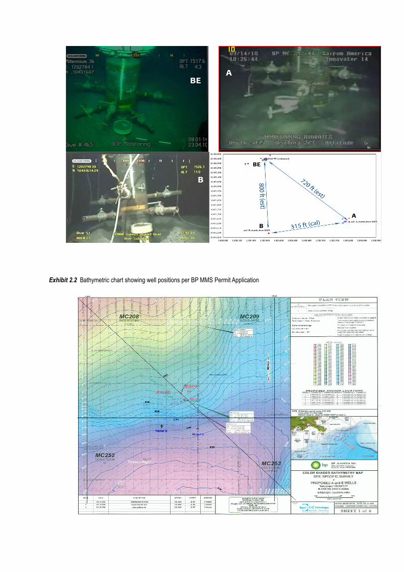
Exhibit 2.2 Bathymetric chart showing well positions per BP MMS Permit Application
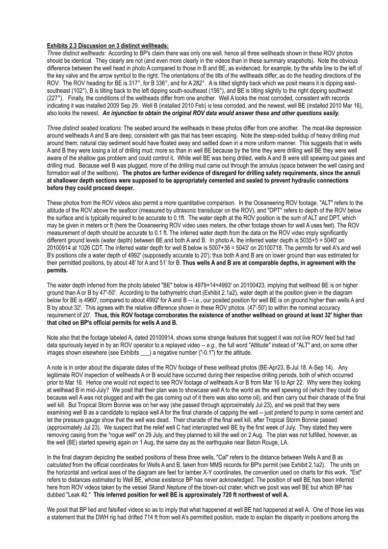
Exhibits 2.3 Discussion on 3 distinct wellheads: Three distinct wellheads: According to BP's claim there was only one well, hence all three wellheads shown in these ROV photos should be identical. They clearly are not (and even more clearly in the videos than in these summary snapshots). Note the obvious difference between the well head in photo A compared to those in B and BE, as evidenced, for example, by the white line to the left of the key valve and the arrow symbol to the right. The orientations of the tilts of the wellheads differ, as do the heading directions of the ROV: The ROV heading for BE is 317°, for B 336°, and for A 282°. A is tilted slightly back which we posit means it is dipping east-southeast (102°), B is tilting back to the left dipping south-southeast (156°), and BE is tilting slightly to the right dipping southwest (227°). Finally, the conditions of the wellheads differ from one another. Well A looks the most corroded, consistent with records indicating it was installed 2009 Sep 29. Well B (installed 2010 Feb) is less corroded, and the newest, well BE (installed 2010 Mar 16), also looks the newest. An injunction to obtain the original ROV data would answer these and other questions easily. Three distinct seabed locations: The seabed around the wellheads in these photos differ from one another. The moat-like depression around wellheads A and B are deep, consistent with gas that has been escaping. Note the steep-sided buildup of heavy drilling mud around them; natural clay sediment would have floated away and settled down in a more uniform manner. This suggests that in wells A and B they were losing a lot of drilling mud; more so than in well BE because by the time they were drilling well BE they were well aware of the shallow gas problem and could control it. While well BE was being drilled, wells A and B were still spewing out gases and drilling mud. Because well B was plugged, more of the drilling mud came out through the annulus (space between the well casing and formation wall of the wellbore). The photos are further evidence of disregard for drilling safety requirements, since the annuli at shallower depth sections were supposed to be appropriately cemented and sealed to prevent hydraulic connections before they could proceed deeper. These photos from the ROV videos also permit a more quantitative comparison. In the Oceaneering ROV footage, "ALT" refers to the altitude of the ROV above the seafloor (measured by ultrasonic transducer on the ROV), and "DPT" refers to depth of the ROV below the surface and is typically required to be accurate to 0.1ft. The water depth at the ROV position is the sum of ALT and DPT, which may be given in meters or ft (here the Oceaneering ROV video uses meters, the other footage shown for well A uses feet). The ROV measurement of depth should be accurate to 0.1 ft. The inferred water depth from the data on the ROV video imply significantly different ground levels (water depth) between BE and both A and B. In photo A, the inferred water depth is 5035+5 = 5040' on 20100914 at 1026 CDT. The inferred water depth for well B below is 5007+36 = 5043' on 20100718. The permits for well A's and well B's positions cite a water depth of 4992' (supposedly accurate to 20'); thus both A and B are on lower ground than was estimated for their permitted positions, by about 48' for A and 51' for B. Thus wells A and B are at comparable depths, in agreement with the permits. The water depth inferred from the photo labeled "BE" below is 4979+14=4993' on 20100423, implying that wellhead BE is on higher ground than A or B by 47'-50'. According to the bathymetric chart (Exhibit 2.1a2), water depth at the position given in the diagram below for BE is 4960', compared to about 4992' for A and B -- i.e., our posited position for well BE is on ground higher than wells A and B by about 32'. This agrees with the relative difference shown in these ROV photos (47'-50') to within the nominal accuracy requirement of 20'. Thus, this ROV footage corroborates the existence of another wellhead on ground at least 32' higher than that cited on BP's official permits for wells A and B. Note also that the footage labeled A, dated 20100914, shows some strange features that suggest it was not live ROV feed but had data spuriously keyed in by an ROV operator to a replayed video -- e.g., the full word "Altitude" instead of "ALT" and, on some other images shown elsewhere (see Exhibits ___) a negative number ("-0.1") for the altitude. A note is in order about the disparate dates of the ROV footage of these wellhead photos (BE-Apr23, B-Jul 18, A-Sep 14). Any legitimate ROV inspection of wellheads A or B would have occurred during their respective drilling periods, both of which occurred prior to Mar 16. Hence one would not expect to see ROV footage of wellheads A or B from Mar 16 to Apr 22. Why were they looking at wellhead B in mid-July? We posit that their plan was to showcase well A to the world as the well spewing oil (which they could do because well A was not plugged and with the gas coming out of it there was also some oil), and then carry out their charade of the final well kill. But Tropical Storm Bonnie was on her way (she passed through approximately Jul 23), and we posit that they were examining well B as a candidate to replace well A for the final charade of capping the well -- just pretend to pump in some cement and let the pressure gauge show that the well was dead. Their charade of the final well kill, after Tropical Storm Bonnie passed (approximately Jul 23). We suspect that the relief well C had intercepted well BE by the first week of July. They stated they were removing casing from the "rogue well" on 29 July, and they planned to kill the well on 2 Aug. The plan was not fulfilled, however, as the well (BE) started spewing again on 1 Aug, the same day as the earthquake near Baton Rouge, LA. In the final diagram depicting the seabed positions of these three wells, "Cal" refers to the distance between Wells A and B as calculated from the official coordinates for Wells A and B, taken from MMS records for BP's permit (see Exhibit 2.1a2). The units on the horizontal and vertical axes of the diagram are feet for lamber X-Y coordinates, the convention used on charts for this work. "Est" refers to distances estimated to Well BE, whose existence BP has never acknowledged. The position of well BE has been inferred here from ROV videos taken by the vessel Skandi Neptune of the blown-out crater, which we posit was well BE but which BP has dubbed "Leak #2." This inferred position for well BE is approximately 720 ft northwest of well A. We posit that BP lied and falsified videos so as to imply that what happened at well BE had happened at well A. One of those lies was a statement that the DWH rig had drifted 714 ft from well A's permitted position, made to explain the disparity in positions among the
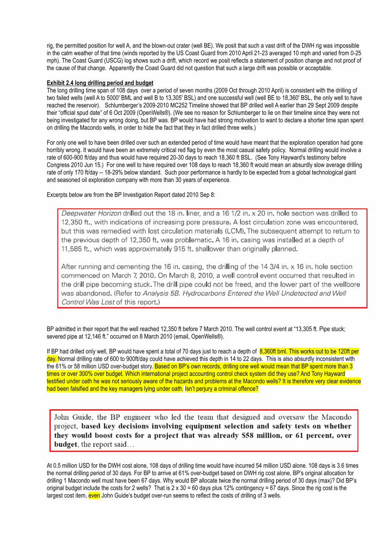
rig, the permitted position for well A, and the blown-out crater (well BE). We posit that such a vast drift of the DWH rig was impossible in the calm weather of that time (winds reported by the US Coast Guard from 2010 April 21-23 averaged 10 mph and varied from 0-25 mph). The Coast Guard (USCG) log shows such a drift, which record we posit reflects a statement of position change and not proof of the cause of that change. Apparently the Coast Guard did not question that such a large drift was possible or acceptable. Exhibit 2.4 long drilling period and budget The long drilling time span of 108 days over a period of seven months (2009 Oct through 2010 April) is consistent with the drilling of two failed wells (well A to 5000' BML and well B to 13,305' BSL) and one successful well (well BE to 18,360' BSL, the only well to have reached the reservoir). Schlumberger’s 2009-2010 MC252 Timeline showed that BP drilled well A earlier than 29 Sept 2009 despite their “official spud date” of 6 Oct 2009 (OpenWells®). (We see no reason for Schlumberger to lie on their timeline since they were not being investigated for any wrong doing, but BP was. BP would have had strong motivation to want to declare a shorter time span spent on drilling the Macondo wells, in order to hide the fact that they in fact drilled three wells.) For only one well to have been drilled over such an extended period of time would have meant that the exploration operation had gone horribly wrong. It would have been an extremely critical red flag by even the most casual safety policy. Normal drilling would involve a rate of 600-900 ft/day and thus would have required 20-30 days to reach 18,360 ft BSL. (See Tony Hayward's testimony before Congress 2010 Jun 15.) For one well to have required over 108 days to reach 18,360 ft would mean an absurdly slow average drilling rate of only 170 ft/day -- 18-29% below standard. Such poor performance is hardly to be expected from a global technological giant and seasoned oil exploration company with more than 30 years of experience. Excerpts below are from the BP Investigation Report dated 2010 Sep 8: BP admitted in their report that the well reached 12,350 ft before 7 March 2010. The well control event at “13,305 ft. Pipe stuck; severed pipe at 12,146 ft.” occurred on 8 March 2010 (email, OpenWells®). If BP had drilled only well, BP would have spent a total of 70 days just to reach a depth of 8,360ft bml. This works out to be 120ft per day. Normal drilling rate of 600 to 900ft/day could have achieved this depth in 14 to 22 days. This is also absurdly inconsistent with the 61% or 58 million USD over-budget story. Based on BP’s own records, drilling one well would mean that BP spent more than 3 times or over 300% over budget. Which international project accounting control check system did they use? And Tony Hayward testified under oath he was not seriously aware of the hazards and problems at the Macondo wells? It is therefore very clear evidence had been falsified and the key managers lying under oath. Isn’t perjury a criminal offence?
At 0.5 million USD for the DWH cost alone, 108 days of drilling time would have incurred 54 million USD alone. 108 days is 3.6 times the normal drilling period of 30 days. For BP to arrive at 61% over-budget based on DWH rig cost alone, BP’s original allocation for drilling 1 Macondo well must have been 67 days. Why would BP allocate twice the normal drilling period of 30 days (max)? Did BP’s original budget include the costs for 2 wells? That is 2 x 30 = 60 days plus 12% contingency = 67 days. Since the rig cost is the largest cost item, even John Guide’s budget over-run seems to reflect the costs of drilling of 3 wells.
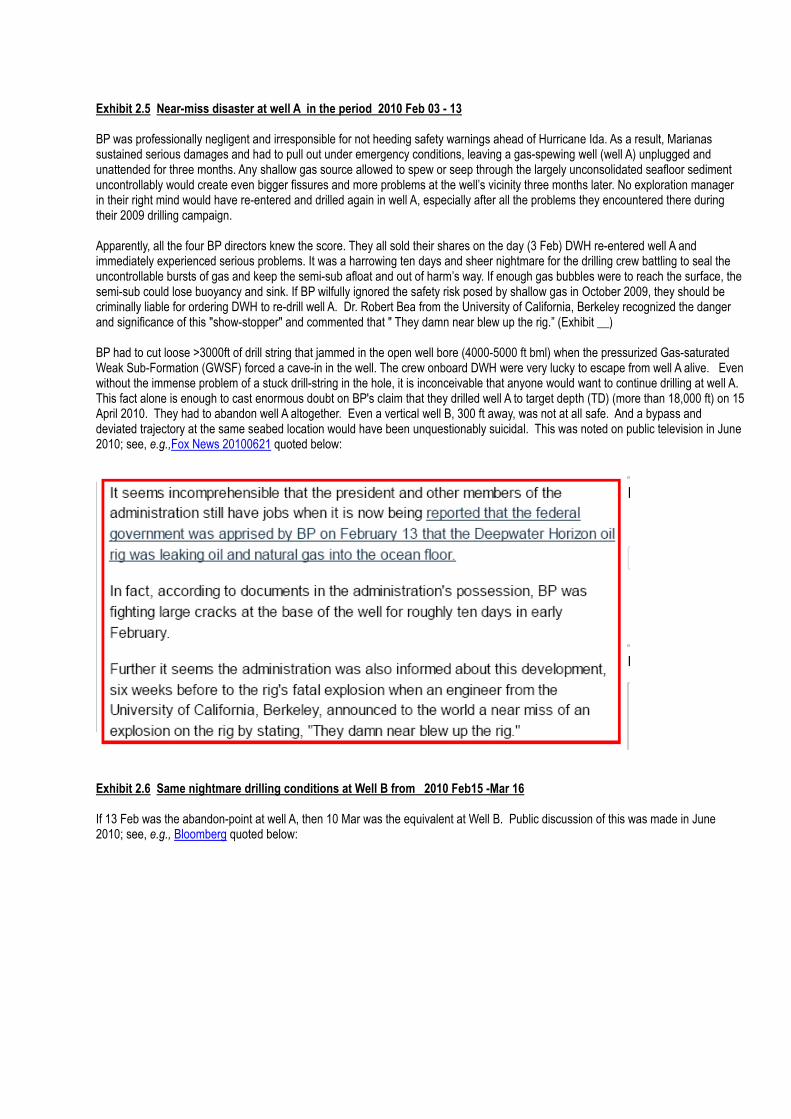
Exhibit 2.5 Near-miss disaster at well A in the period 2010 Feb 03 - 13 BP was professionally negligent and irresponsible for not heeding safety warnings ahead of Hurricane Ida. As a result, Marianas sustained serious damages and had to pull out under emergency conditions, leaving a gas-spewing well (well A) unplugged and unattended for three months. Any shallow gas source allowed to spew or seep through the largely unconsolidated seafloor sediment uncontrollably would create even bigger fissures and more problems at the well’s vicinity three months later. No exploration manager in their right mind would have re-entered and drilled again in well A, especially after all the problems they encountered there during their 2009 drilling campaign. Apparently, all the four BP directors knew the score. They all sold their shares on the day (3 Feb) DWH re-entered well A and immediately experienced serious problems. It was a harrowing ten days and sheer nightmare for the drilling crew battling to seal the uncontrollable bursts of gas and keep the semi-sub afloat and out of harm’s way. If enough gas bubbles were to reach the surface, the semi-sub could lose buoyancy and sink. If BP wilfully ignored the safety risk posed by shallow gas in October 2009, they should be criminally liable for ordering DWH to re-drill well A. Dr. Robert Bea from the University of California, Berkeley recognized the danger and significance of this "show-stopper" and commented that " They damn near blew up the rig.” (Exhibit __) BP had to cut loose >3000ft of drill string that jammed in the open well bore (4000-5000 ft bml) when the pressurized Gas-saturated Weak Sub-Formation (GWSF) forced a cave-in in the well. The crew onboard DWH were very lucky to escape from well A alive. Even without the immense problem of a stuck drill-string in the hole, it is inconceivable that anyone would want to continue drilling at well A. This fact alone is enough to cast enormous doubt on BP's claim that they drilled well A to target depth (TD) (more than 18,000 ft) on 15 April 2010. They had to abandon well A altogether. Even a vertical well B, 300 ft away, was not at all safe. And a bypass and deviated trajectory at the same seabed location would have been unquestionably suicidal. This was noted on public television in June 2010; see, e.g.,Fox News 20100621 quoted below:
Exhibit 2.6 Same nightmare drilling conditions at Well B from 2010 Feb15 -Mar 16 If 13 Feb was the abandon-point at well A, then 10 Mar was the equivalent at Well B. Public discussion of this was made in June 2010; see, e.g., Bloomberg quoted below:
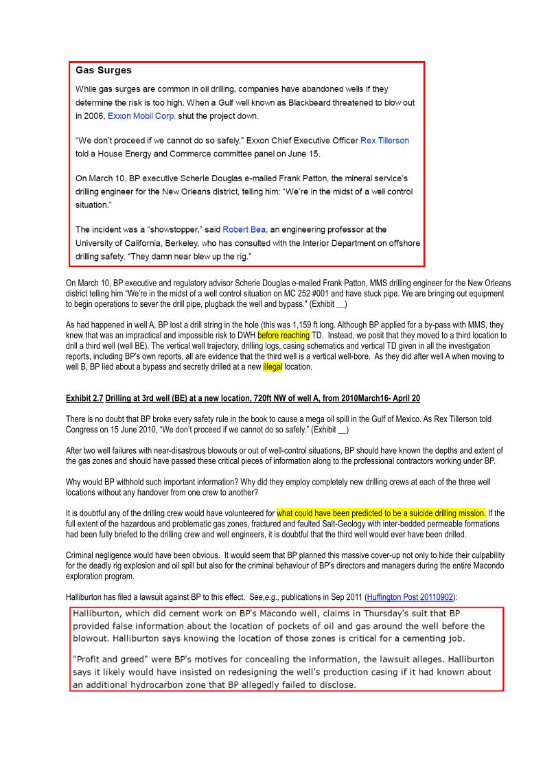
On March 10, BP executive and regulatory advisor Scherie Douglas e-mailed Frank Patton, MMS drilling engineer for the New Orleans district telling him “We’re in the midst of a well control situation on MC 252 #001 and have stuck pipe. We are bringing out equipment to begin operations to sever the drill pipe, plugback the well and bypass." (Exhibit __) As had happened in well A, BP lost a drill string in the hole (this was 1,159 ft long. Although BP applied for a by-pass with MMS, they knew that was an impractical and impossible risk to DWH before reaching TD. Instead, we posit that they moved to a third location to drill a third well (well BE). The vertical well trajectory, drilling logs, casing schematics and vertical TD given in all the investigation reports, including BP’s own reports, all are evidence that the third well is a vertical well-bore. As they did after well A when moving to well B, BP lied about a bypass and secretly drilled at a new illegal location. Exhibit 2.7 Drilling at 3rd well (BE) at a new location, 720ft NW of well A, from 2010March16- April 20 There is no doubt that BP broke every safety rule in the book to cause a mega oil spill in the Gulf of Mexico. As Rex Tillerson told Congress on 15 June 2010, “We don’t proceed if we cannot do so safely.” (Exhibit __) After two well failures with near-disastrous blowouts or out of well-control situations, BP should have known the depths and extent of the gas zones and should have passed these critical pieces of information along to the professional contractors working under BP. Why would BP withhold such important information? Why did they employ completely new drilling crews at each of the three well locations without any handover from one crew to another? It is doubtful any of the drilling crew would have volunteered for what could have been predicted to be a suicide drilling mission. If the full extent of the hazardous and problematic gas zones, fractured and faulted Salt-Geology with inter-bedded permeable formations had been fully briefed to the drilling crew and well engineers, it is doubtful that the third well would ever have been drilled. Criminal negligence would have been obvious. It would seem that BP planned this massive cover-up not only to hide their culpability for the deadly rig explosion and oil spill but also for the criminal behaviour of BP's directors and managers during the entire Macondo exploration program. Halliburton has filed a lawsuit against BP to this effect. See,e.g., publications in Sep 2011 (Huffington Post 20110902):
Exhibit 2.8 Not possible for DWH to have moved 714 ft northwest, as noted on 21 Apr at2204 CDT
On 21 Apr at 2204 CDT BP first reported that the DWH rig (aka MODU for mobile offshore drilling unit) had moved by 714 ft northwest.
At 2205 the Coast Guard log reported: “JH briefed by MSU Morgan city that DWH was reported to have moved by 714 ft NW held in
place by marine riser”.
In such calm weather, it was unlikely that the MODU would have moved by 714 ft in any direction. Moreover, a semi-sub constrained
by the marine riser is unlikely to move 714 ft without sinking an equivalent of 52 ft to compensate for the vertical height reduction from
a fixed seabed base. We posit that DWH was at its original position of 714 ft northwest of well A when it started drilling the third well
(well BE) on 16 March 2010 and remained at this location until it sank on 22 April after 1320 CDT as witnessed and recorded by the
US Coast Guard in their vessel log.
In the heat of emergency fire fighting and rescue operations, why was it necessary for BP to measure the “shift” (if indeed DWH had
moved) so accurately to 1ft? An estimate of 700 ft would have sufficed and would not have any difference to the fire fighting or rescue
efforts. And how could BP measure rig position to an accuracy of 1 ft on an intensely burning rig? They would either have had to send
an ROV to the underside of the rig to get a position fix or have calculated the distance from well A using already known (existing)
coordinates. Why would BP expose a multimillion ROV to unnecessary risks beneath a burning rig surrounded a floating pool of
burning fuel, just to measure a meaningless position shift accurate to 1 ft? Unless the ROV was sent there for another covert purpose
and the measurement of the shift was just a by-product of that covert mission.
Or if that accurate distance was calculated from existing coordinates. How could there have been such known coordinates prior to the
first gas blowout on 20 April at 2200 CDT unless the rig had been there since the third well was spudded on 16 March 2010?
We posit that this fake "documentation" of a wind-induced drift in rig position was BP's ploy to prevent the public from noticing that the
DWH rig was actually at a different location and that the blowout had occurred at a different well (well BE).
1b. Sequence of the first gas blowout, broken riser, sunken DWH and second explosion
How could a marine riser pipe falling through the water column bury itself completely beneath the seafloor into a trench several
hundred meters (m) long and yet show no visible connection to an even deeper pipe within a steep-sided crater more than 5 m deep?
Further, the ROV tracking trench (and the pipe) was generally heading NW (approximately 330-3450), which means that the sunken
pipe was oriented NW-SE. The pipe in the crater was spewing oil toward the south and was clearly dipping into the ground towards the
north. For the oil-spewing pipe to be connected to well A in the south, it had to dip southward and not northward. Clearly Well A cannot
be connected to a pipe (720 ft north of it) that is dipping northward, away from Well A. If Well A and the oil-spewing pipe were not
physically connected, how did the oil from well A flow to the blown crater north of it? This is a physical impossibility. This evidence
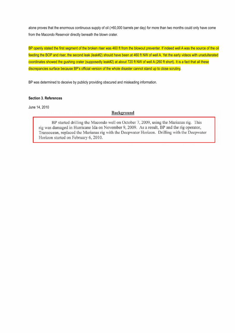
alone proves that the enormous continuous supply of oil (>60,000 barrels per day) for more than two months could only have come
from the Macondo Reservoir directly beneath the blown crater.
BP openly stated the first segment of the broken riser was 460 ft from the blowout preventer. If indeed well A was the source of the oil
feeding the BOP and riser, the second leak (leak#2) should have been at 460 ft NW of well A. Yet the early videos with unadulterated
coordinates showed the gushing crater (supposedly leak#2) at about 720 ft NW of well A (260 ft short). It is a fact that all these
discrepancies surface because BP’s official version of the whole disaster cannot stand up to close scrutiny.
BP was determined to deceive by publicly providing obscured and misleading information.
Section 3. References June 14, 2010