Botanical Survey - planning.org.uk
34
Botanical Survey Site: Compass Point, Bude Client: Devon and Cornwall Ecology Date: July 2021 Trewetha Port Isaac Cornwall www.ecologypartners.co.uk
Transcript of Botanical Survey - planning.org.uk

Botanical Survey
Site: Compass Point, Bude
Client: Devon and Cornwall Ecology
Date: July 2021
Trewetha Port Isaac
Cornwall www.ecologypartners.co.uk

EP21/203 Compass Point, Bude. Botanical Survey
2
July 2021
Document Control
Jo
b R
ef.
EP21203
Ve
rsio
n
01
Iss
ue
da
te
20th July 2021
Su
rvey
or
John Sproull MSc, MCIEEM
Au
tho
rs
John Sproull MSc, MCIEEM
Disclosure
The information and advice presented within this report is based on the professional and true
opinions of Ecology Partners and is written in accordance with the CIEEM Code of
Professional Conduct.

EP21/203 Compass Point, Bude. Botanical Survey
3
July 2021
Table of Contents
Page
1. Introduction 4
2. Methodology 4
2.1 Personnel 4
2.2 Review of existing data 4
2.3 NVC survey 4
2.4 Limitations 5
3. Results 5
3.1 Designation 5
3.2 Habitat descriptions 5
3.3 Notable species 14
4. Proposed works and recommendations 16
5. References 20
Appendix 1: Maps 21
Map 1: Site location
Map 2: Habitat mapping
Map 3: Notable species
Appendix 2: Species list & quadrat data 27

EP21/203 Compass Point, Bude. Botanical Survey
4
July 2021
1. Introduction
Ecology Partners were commissioned by Devon and Cornwall Ecology on behalf of Bude - Stratton Town Council (BSTC) in May 2021 to carry out a botanical survey of land surrounding the Storm Tower on Compass Point, Bude. Built as a lookout in 1835, the tower is a Grade II listed stone structure approximately 3.7m wide and just under 7m tall and a prominent local landmark. Due to coastal erosion the cliff edge is c.4 metres away and it is proposed to dismantle the tower and rebuild it on a new site c.100m further inland (at grid reference SS2015106378).
The Storm Tower is situated within Efford Down which is designated as part of both a Special Area of Conservation (SAC) and Site of Special Scientific Interest (SSSI) and supports important areas of maritime grassland and heathland as well as a number of notable species. The purpose of this contract is to survey and assess the habitats present within the areas likely to be affected by the works. The proposals are reviewed and recommendations are made as to how impacts might be minimised.
The survey area focuses on Compass Point, where the tower is situated and the promontory of high ground behind it including the site to which the tower will be relocated c.100m to the east and immediate surrounding areas as well as the proposed access route which follows an existing public footpath along the valley bottom immediately to the south.
The site location and survey area is shown on Map 1, Appendix 1.
2. Methodology
2.1. Personnel
This project has been undertaken by John Sproull MSc, MCIEEM. John is a trained field botanist with over 15 years experience of working as an ecological consultant regularly undertaking NVC and other specialist plant survey and habitat assessment work in Cornwall and other parts of the UK.
2.2. Review of existing data
Prior to undertaking the survey work existing data relating to the site (as listed below) was reviewed to inform the survey:
Information relating to SSSI and SAC designation available on the MAGIC Mapping website (DEFRA, 2021).
Notable vascular plant species recorded within the 1km grid square SS2006 as held by the Environmental Records Centre for Cornwall and the Isles of Scilly (ERCCIS). These records were previously supplied by the client to inform a survey of a nearby site (a proposed new cycle path between Summerleaze – Crooklets also for BSTC).
Cornwall Biodiversity Network desk study data (CBN, 2021).
2.3. NVC survey
A targeted National Vegetation Classification (NVC) survey was undertaken on Tuesday 15th June 2021 to sample and map the main vegetation communities on the headland. A series of quadrats was taken within representative homogeneous stands of vegetation across the

EP21/203 Compass Point, Bude. Botanical Survey
5
July 2021
site. Habitats along the proposed access route either side of an existing public footpath leading up to the tower from Church Path along the valley bottom immediately to the south were also assessed but not surveyed in detail.
A list of the vascular plant species occurring within the main vegetation communities was recorded and records made of any notable species seen during the survey. Point data, including quadrat locations and other notable features were recorded using a Garmin Oregon 750 GPS unit and representative digital photographs were taken. Quadrat data were tabulated in Excel and assigned to community types by reference to the vegetation keys and floristic tables in Rodwell, (1991 et seq) and digitised in QGIS version 3.12.3-București at 1: 5000.
2.4. Limitations
The survey was undertaken at an appropriate time of year during appropriate dry, warm weather and with free access to all parts of the site.
The NVC system seeks to assign vegetation samples (quadrats) to (sub) communities by assessing the degree to which samples match published descriptions based upon species composition, constancy and abundance. In reality vegetation communities exist on a continuum grading into one another with floristics moderated by a range of factors (such as soil type, altitude, prevailing weather patterns etc.) as well as human intervention. The vegetation at Compass Point shows varying degrees of maritime influence moving inland from the cliff edge with transitions in part mediated by varying degrees of exposure to salt spray deposition and the effects of heavy foot-fall in areas associated with footpaths. Consequently it can be difficult to identify boundaries on the ground, to separate and assign communities within the NVC. As a result it is sometimes necessary to take a ‘best-fit’ approach and / or to map transitional habitats (where elements of more than one NVC community are present).
As per the specification for this contract representative quadrats only were taken of each
dominant habitat type to allow determination of the main plant communities within the NVC using the judgement of the surveyor. The full NVC methodology (Rodwell, 1991 et seq) requires that a minimum of 5 quadrats are taken per (sub) community (this also enables data analysis using appropriate software such as MAVIS).
Notable species were comprehensively sought within quadrats and within areas likely to be impacted by the proposed work but could not be exhaustively searched for across the entire area within the time available. It is also acknowledged that some flowering plant species may not have been visible or readily identifiable at the time of the survey. It remains possible therefore that further notable species, not identified during the survey, may exist within the vicinity.
Given the extent of the site, the nature of the habitats present and the work proposed these are not considered to represent significant limitations to the findings of this report.
3. Results
Findings are presented below with a brief description of each of the sub -communities identified within the main habitat types and illustrative photos.
Habitat distribution is shown on Map 2 in Appendix 1 along the locations of quadrats and target notes.

EP21/203 Compass Point, Bude. Botanical Survey
6
July 2021
Quadrat data and a species list of the dominant vascular plant species within each habitat type is included in Appendix 2
3.1. Designation
Both the main NVC survey area and the proposed access route lie within the following statutory sites of nature conservation interest:
Tintagle-Marsland-Clovelly Coast SAC This 60km long site comprises of mostly
hard, vertical, strongly maritime coastal cliff with intervening slumped sections. It is designated for the occurrence of the Annex 1 habitats1 Vegetated sea cliffs of the Atlantic and Baltic Coasts, Old sessile oak woods with Ilex and Blechnum in the British Isles and European dry heaths.
Bude Coast SSSI The cliffs within this site which stretches from Furzey Cliff to the
north of Bude to Efford Cliff to the south exhibit a number of important geological features associated with the Bude Formation including Carboniferous sandstone which (unusually in Cornwall) gives rise to the local occurrence of herb rich calcareous grassland species including a number of rare and locally restricted plants.
3.2. Habitat descriptions
Maritime grassland
Compass Point and the promontory behind it including the Storm Tower and the site to which it will be relocated (shown as the NVC survey area on Map 2 ) are dominated by a mixed grassland assemblage, showing declining maritime influence moving inland from the cliff edge. For the most part the area is referable to different sub-communities of MC8 Festuca rubra-Armeria maritima maritime grassland. This community is characterised by a generally closed sward dominated by red fescue (Festuca rubra) with a wide range of associates depending upon the form it takes but typically including species such as thrift (Armeria maritima), plantains (Plantago species), creeping bent (Agrostis stolonifera) and here varying amounts of Yorkshire fog (Holcus lanatus).
MC8 is the most maritime of the grasslands proper found on coastal cliffs in the UK typically occupying a zone above rock-crevice communities on cliffs below and more mesic grassland communities as one moves inland and maritime influence declines.
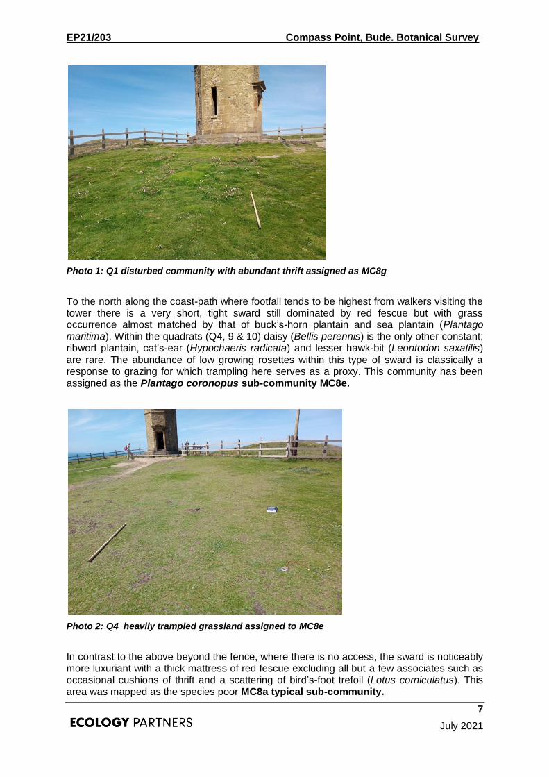
Immediately to the south of the Storm Tower quadrats 1 and 2 were taken within a dry, disturbed area where thrift is more or less co-dominant with red fescue with very few associates other than occasional – locally frequent buck’s-horn plantain (Plantago coronopus) and ribwort plantain (P. lanceolata), occasional hawk-bit (Leontodon saxatilis) and scattered white clover (Trifolium repens). This area has been mapped as MG8g the Armeria maritima-dominated sub-community which is typical of more maritime exposures where drainage is excessive and there may be some degree of erosion (as here, presumably resulting from footfall) such that thrift gains a competitive advantage with its deep fleshy rootstock.
1 As listed on Annex 1 of the EC Habitats Directive (CEC, 1992) and are therefore recognised as
being habitats of European nature conservation importance
EP21/203 Compass Point, Bude. Botanical Survey
7
July 2021
Photo 1: Q1 disturbed community with abundant thrift assigned as MC8g
To the north along the coast-path where footfall tends to be highest from walkers visiting the tower there is a very short, tight sward still dominated by red fescue but with grass occurrence almost matched by that of buck’s-horn plantain and sea plantain (Plantago maritima). Within the quadrats (Q4, 9 & 10) daisy (Bellis perennis) is the only other constant; ribwort plantain, cat’s-ear (Hypochaeris radicata) and lesser hawk-bit (Leontodon saxatilis) are rare. The abundance of low growing rosettes within this type of sward is classically a response to grazing for which trampling here serves as a proxy. This community has been assigned as the Plantago coronopus sub-community MC8e.
Photo 2: Q4 heavily trampled grassland assigned to MC8e
In contrast to the above beyond the fence, where there is no access, the sward is noticeably more luxuriant with a thick mattress of red fescue excluding all but a few associates such as occasional cushions of thrift and a scattering of bird’s-foot trefoil (Lotus corniculatus). This area was mapped as the species poor MC8a typical sub-community.

EP21/203 Compass Point, Bude. Botanical Survey
8
July 2021
Photo 3: cliff edge near to Q5
Red fescue remains dominant across the bulk of the central part of the promontory (Q3 and Q8) the sward varying in stature and species richness. The occurrence of species characteristic of inland neutral grassland at moderate levels of abundance, most notably Yorkshire fog but also cock’s-foot (Dacylis glomerata) and crested dog’s-tail (Cynosurus cristatus) suggests MC8d the Holcus lanatus sub-community.
Photo 4: Q3 ranker intermediate sward with Yorkshire fog treated as MC8d
This transition toward more mesic grassland is further consolidated moving south toward the fence (Q6 and Q7) with fewer maritime obligates, increased abundance of the grasses above and the addition of species such as common bent (Agrostis capillaris) and bulbous buttercup (Ranunculus bulbosus) as well as increased amounts of clover (Trifolium repens and T.pratense). This area has been mapped as transitional between MC8d and MC9b
EP21/203 Compass Point, Bude. Botanical Survey
9
July 2021
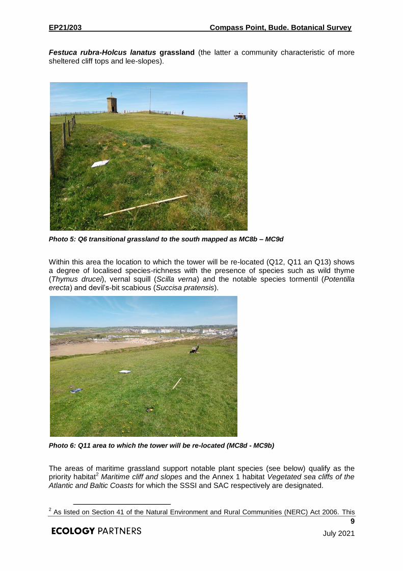
Festuca rubra-Holcus lanatus grassland (the latter a community characteristic of more sheltered cliff tops and lee-slopes).
Photo 5: Q6 transitional grassland to the south mapped as MC8b – MC9d
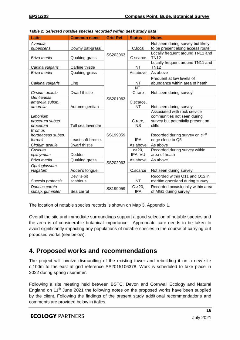
Within this area the location to which the tower will be re-located (Q12, Q11 an Q13) shows a degree of localised species-richness with the presence of species such as wild thyme (Thymus drucei), vernal squill (Scilla verna) and the notable species tormentil (Potentilla erecta) and devil’s-bit scabious (Succisa pratensis).
Photo 6: Q11 area to which the tower will be re-located (MC8d - MC9b)
The areas of maritime grassland support notable plant species (see below) qualify as the priority habitat2 Maritime cliff and slopes and the Annex 1 habitat Vegetated sea cliffs of the Atlantic and Baltic Coasts for which the SSSI and SAC respectively are designated.
2 As listed on Section 41 of the Natural Environment and Rural Communities (NERC) Act 2006. This

EP21/203 Compass Point, Bude. Botanical Survey
10
July 2021
Without appropriate care and mitigation it is considered that movement of the tower has the capacity to impact on areas of maritime grassland as follows:
Disturbance to / degradation of areas around existing location of tower as required to establish a working area / compound and facilitate dismantling (of tower as well as associated hard-standing / paved surround) including lay down / storage / loading area for transit to new site – size of area required to be confirmed. Potential for ground disturbance and compaction due to machinery and vehicle movements and dust / rubble deposition or release of other pollutants within the area.
Disturbance to / degradation along c.100m x c.2m wide transit route between existing and new site – ground disturbance and compaction due to vehicle movements used to transport stone and other materials.
Habitat loss at the new site to accommodate the footprint of the relocated tower and disturbance to / degradation of the surrounding area as required to establish a working area / compound and facilitate re-construction (of tower as well as any associated hard-standing / paved surround) including lay down / storage area – size of area required to be confirmed. Potential for ground disturbance and compaction due to machinery and vehicle movements and dust / rubble deposition or release of other pollutants within the area.
A precautionary approach should be followed and a methodology developed to minimise potential impacts upon the maritime grassland habitat as discussed in Section 4 below.
Heath
Within the extreme eastern end of the NVC survey area (Q14 and Q15) Western gorse (Ulex gallii) dominates a heathland assemblage with frequent heather (Calluna vulgaris) at low levels of abundance. Associated species are few: toward the edges and within openings in the canopy wild thyme, betony (Stachys officinalis), common dog violet (Viola riviniana) and green-ribbed sedge (Carex binervis) add some diversity and the notable species dodder (Cuscuta epithymum), parasitic on gorse is locally frequent. This community matches the species-poor sub-community of Calluna vulgaris –Ulex gallii heath H8a.
The area of heath supports notable plant species (see below) and qualifies as both the priority habitat Lowland heathland and the Annex 1 habitat European dry heath.
Although this habitat should not be directly impacted by the proposal the tower will be relocated to an area close to the area of heathland. Without appropriate care it is considered that re-construciton has the capacity to impact on areas of heath as follows:
Direct disturbance as a result of vehicle movements, storage of materials etc. resulting in damage to vegetation and ground compaction
Habitat degradation due to dust / rubble deposition or release of other pollutnats within the area
See Section 4 for discussion of precautionary approach to be followed and methodology to be adopted to minimise potential impacts upon this habitat.
legislation requires the Secretary of State to publish a list of species of flora and fauna and habitats considered to be of principal importance for the purpose of conserving biodiversity. It is the duty of Local Authorities to further the conservation of NERC / Section 41 (S41) habitats and species under section 40 of NERC Act and in accordance with the National Planning Policy Framework (NPPF, 2012).

EP21/203 Compass Point, Bude. Botanical Survey
11
July 2021
Photo 6: Q14, H8 heath
Semi-improved grassland
The access route follows an established pedestrian access track running roughly east-west along the valley bottom from Church Path to a gate c.40m from the tower.
The track itself is well used up to c.2m wide and supports a short, compacted sward dominated by varying amounts of red fescue and common bent with frequent-locally abundant perennial rye-grass (Lolium perenne), occasional Yorkshire fog and crested dog’s-tail and locally abundant rosette forming species such as ribwort plantain and daisy.
Alongside the access route grassland within the valley bottom and surrounding gentle slopes is varied both physiognomically and in terms of species composition appearing in places rank and rather poor, elsewhere more open and species-rich. Cock’s-foot and Yorkshire fog tend to be abundant throughout, the former dominating locally; red fescue too is abundant, false oat-grass (Arrhenatherum elatius), smooth meadow-grass (Poa trivialis), common couch (Elymus repens), crested dog’s-tail and soft brome (Bromus hordaceous) are all locally frequent. Black knapweed (Centaurea nigra) and bird’s-foot trefoil are frequent often with white and / or red clover (Triflolium repens and / or T. pratense). Restharrow (Ononis repens) is locally frequent on richer south-facing slopes and hogweed (Heracleum sphondylium) becomes frequent within ranker stands with occasional creeping thistle (Cirsium arvense).
This assemblage, although not sampled in detail resembles MG1 Arrhenatherum elatius grassland with probable stands of both the species-poor Festuca rubra sub-community (MG1a) and the richer Centaurea nigra sub-community (MG1e). MG1 is characteristic of
irregularly grazed / cut grassland over circumneutral soils in the British lowlands and is often found at the landward end of maritime grassland successional sequences.

EP21/203 Compass Point, Bude. Botanical Survey
12
July 2021
Photo 7: access track looking east with semi-improved grassland (MG1) either side
Photo 8: as above looking north west
Within a flushed area in the valley bottom (at target note 7) tufted hair-grass (Deschampsia cespitosa) is locally abundant with a suite of poor-fens species including hairy sedge (Carex hirta), common sedge (C. nigra) and glaucous sedge (C. flacca), fleabane (Pulicaria dysenterica) and silverweed (Potentilla anserina). This community appeared fragmented and was not assessed in detail but bears some affinity to MG9 Holcus lanatus – Deschampsi cespitosa grassland.
Within the valley bottom at the eastern extent of the area to the north of the gate leading to Church Path (target notes 11 and 12) there is a community featuring a suite of species associated with calcareous grassland. Whilst red fescue remains more or less dominant the sward is markedly more open and species-rich with locally abundant carices (including glaucous sedge); quaking grass (Briza media), carline thistle (Carlina vulgaris), ladies-bedstraw (Galium verum), betony, devil’s-bit scabious, greater knapweed (Centaurea scabiosa), restharrow, wild thyme and south-marsh orchid (Dactylorhiza praetermissa) are
all locally frequent. There is a further colony of southern marsh orchid at target note 10.

EP21/203 Compass Point, Bude. Botanical Survey
13
July 2021
Although not quantitatively sampled this assemblage bears elements of CG1 Festuca ovina – Carlina vulgaris grassland very unusual in Cornwall and of considerable interest.
Whilst the grassland assemblage along the established track itself is of relatively low
intersest more species rich areas of semi-improved grassland support a number of notable
species (see below) and may qualify as the priority habitat Lowland meadow. Areas
supporting calcareous species may also qualify as Lowland calcareous grassland for which
the SSSI is in part designated.
Although there should be no direct impact to these areas during work a precautionary
approach should be followed to ensure that species rich areas supporting notable species
are protected to prevent degradation associated with vehicle movements and storage of
materials etc. during work. See Section 4 below.
Photo 9: showing area of species-rich calcareous grassland north of access track (TN12)
Photo 10: southern marsh-orchid with quaking grass within species rich grassland at TN12

EP21/203 Compass Point, Bude. Botanical Survey
14
July 2021
Photo 11: looking north toward TN11. Carline thistle, quaking grass and greater knapweed
locally frequent in this area
Scrub
Scrub is a very minor component of the survey area and was not looked at in any detail
during the survey. Several scattered stands have been mapped along the eastern half of the
access roué as shown on Map 2. Bramble (Rubus fruticosus) dominates with locally
abundant common nettle (Urtica dioica), cleavers (Galium aparine) and coarse grasses such
as false oat-grass and cock’s-foot.
This assemblage may offer some habitat for faunal species such as nesting birds but
otherwise is of no particular value and has the potential to spread at the expense of
surrounding more species-rich areas of grassland if left unchecked and might be targeted in
future management of the site.
3.3. Notable species Notable species recorded during the survey are shown in Table 1 overleaf:

EP21/203 Compass Point, Bude. Botanical Survey
15
July 2021
Table 1: Notable species recorded during the survey
Latin Common name Grid Ref. Status Notes
Briza media Quaking grass SS20380636 SS20350637 C.scarce
Locally frequent at TN11 and TN12
Bromus hordeaceus subsp. ferronii Least Soft-brome SS20040632 IPA
Recorded on cliff edge near to TN5
Calluna vulgaris Ling SS2018606383 SS2018406394 NT
Recorded within heath at Q14,Q15
Carlina vulgaris Carline thistle SS20380636 SS20350637 NT
Locally frequent within TN11 and TN12
Cuscuta epithymum Dodder SS2018606383
C.>20, IPA, VU
Locally frequent within heath at Q14
Daucus carotta ssp gummifer Sea carrot N/a
IPA, C.>20
Occasional within area of MG1
Potentilla erecta Tormentil
SS2011406350 SS2014706572 SS2016506331 SS2015406390 SS2015406390 SS2018606383 NT
Locally frequent in maritime grassland. Recorded in Q6, Q7, Q11, Q12, Q13 and Q14
Succsia pratensis Devil's-bit scabious
SS20380636 SS20350637 NT
Recorded in maritime grassland at Q11 and Q12
Status key (CBN, 2021)
Abb. Status
C.rare Cornwall rare: in 1-3 tetrads
C.local Cornwall local: in 4-10 tetrads
C.scarce Cornwall scarce: in 11-20 tetrads
C.>20 Cornwall >20 tetrads but included within Rare Plant Resister
NS Nationally scarce: occurring within 16-100 tetrads within the UK
NT Near threatened (Stroh et al, 2014)
VU Vulnerable (Stroh et al, 2014)
IPA Important Plant Area species (Pantlife, )
Selected notable species recorded in desk study data within close proximity to the survey
area and access route are shown in table 2 below. Note that only species considered likely
still to be present and for which suitable habitat is present have been included: older records
and records for species associated with habitats not present within the site (such as aquatic
habitats and arable) have been excluded.
EP21/203 Compass Point, Bude. Botanical Survey
16
July 2021
Table 2: Selected notable species recorded within desk study data
Latin Common name Grid Ref. Status Notes
Avenula pubescens Downy oat-grass
SS203063
C.local Not seen during survey but likely to be present along access route
Briza media Quaking grass C.scarce Locally frequent around TN11 and TN12
Carlina vulgaris Carline thistle NT Locally frequent around TN11 and TN12
Briza media Quaking-grass
SS201063
As above As above
Calluna vulgaris Ling NT Frequent at low levels of abundance within area of heath
Cirsium acaule Dwarf thistle NT,
C.rare Not seen during survey
Gentianella amarella subsp. amarella Autumn gentian
C.scarce, NT Not seen during survey
Limonium procerum subsp. procerum Tall sea lavendar
C.rare, NS
Associated with rock crevice communities not seen during survey but potentially present on cliffs
Bromus hordeaceus subsp. ferronii Least soft-brome
SS199059 IPA
Recorded during survey on cliff edge close to Q5
Cirsium acaule Dwarf thistle
SS202063
As above As above
Cuscuta epithymum Dodder
c>20, IPA, VU
Recorded during survey within area of heath
Briza media Quaking grass As above As above
Ophioglossum vulgatum Adder's tongue C.scarce Not seen during survey
Succsia pratensis Devil's-bit scabious NT
Recorded within Q11 and Q12 in maritim grassland during survey
Daucus carota subsp. gummifer Sea carrot
SS199059 C.>20, IPA
Recorded occasionally within area of MG1 during survey
The location of notable species records is shown on Map 3, Appendix 1.
Overall the site and immediate surroundings support a good selection of notable species and
the area is of considerable botanical importance. Appropriate care needs to be taken to
avoid significantly impacting any populations of notable species in the course of carrying out
proposed works (see below).
4. Proposed works and recommendations
The project will involve dismantling of the existing tower and rebuilding it on a new site
c.100m to the east at grid reference SS2015106378. Work is scheduled to take place in
2022 during spring / summer.
Following a site meeting held between BSTC, Devon and Cornwall Ecology and Natural
England on 11th June 2021 the following notes on the proposed works have been supplied
by the client. Following the findings of the present study additional recommendations and
comments are provided below in italics.

EP21/203 Compass Point, Bude. Botanical Survey
17
July 2021
Access
Access from the private road Church Path will be through the field gate. The route then follows the established grassland path to the top gate and will then cross c. 40m of maritime grassland to reach the existing tower. The new location is c.100m to the east across maritime grassland as described above.
Due to the extent of public access it is considered to be impractical to seal off the route to the public. The route will be marked out with discrete signage and pins such as electric fencing stakes (or similar) to alert people of construction activity and demarcate the route for contractors. The exact route should be chosen to follow
existing paths and barer areas where they already exist but care must be taken not to add to existing areas of erosion. Appropriate trackway should be used when periods of vehicular movement are predicted and where there is potential for this to create rutted tracks along access routes. Impacts should be carefully monitored and trackway left in place only for as long as it is needed to avoid prolonged shading leading to dying back of the sward. Trackway should be appropriately stored within a designate compound when not in use.
At tender Contractors will be advised that all site traffic is to be managed carefully both for health and safety as well as overseeing driving. There will be a strict speed limit imposed. The importance of sticking to demarcated routes and not cutting corners or taking short-cuts must be stressed to contractors in order that sensitive areas of habitat and areas with notable species can be avoided. Consideration to the need for passing places and turning areas must be given in planning and marking out of access routes.
The Contractors will be obliged to state the plant vehicles they propose as part of a tender method statement and to avoid high impact vehicles in favour of load spreading. Every effort must be made to keep vehicle movements to a minimum with access gained on foot wherever possible
It is anticipated that the following operations will apply:-
- Delivery and removal of scaffolding and compound materials such as fencing.
- General material deliveries such as mortar, pavings, bedding sand, roofing and some stone for replacements.
- Concrete supply for the new base foundation. This is a small quantity and likely to be delivered pre-mixed for quality control and brought up to the new tower site in a shuttle action using a dumper.
- General material movement will be restricted to low impact vehicles including the use of tracked excavators.
- Parking will be off site.
Site Compounds
Both the existing tower and the new location will require a site working area. As the existing site has already been affected by pedestrian wear and tear this will probably be the main compound for stone storage and cleaning. The sites will be restricted to need and work outside of these controlled areas will not be permitted.
The size of areas required to establish compounds and working areas (for dismantling, stone-cleaning, lay down, storage, loading / unloading and re-building etc.) should be determined and areas demarcated on the ground avoiding areas supporting notable species as far as possible. Compounds should be fenced off with a secure fencing type suited to the exposed location throughout the period of work to avoid impacts to surrounding areas.

EP21/203 Compass Point, Bude. Botanical Survey
18
July 2021
Post the site visit meeting it has been suggested that a small compound may be located at the lower gate if a suitable spot can be found. There has been notice of potential issues using the private road and so storage here of the site dumper may be advantageous. An appropriate species poor area avoiding the area of calcareous grassland around target notes 11 and 12 should be identified for this purpose. It is suggested that the area of calcareous grassland is cordoned off to prevent degradation during works.
If vegetation trimming / clearance is required to establish compounds regard should be paid to the potential presence of protected faunal species (such as reptiles and nesting birds) in carrying out the clearance.
Damage & Pollution Measures
The impact of site traffic will be monitored closely with daily visits by the council’s staff and further measures such as matting will be considered if the ground condition becomes a problem. (See above)
In operations that involve waste material (dust from stonework) and potentially harmful materials (lime and concrete) protective measures will be employed including geotextile protection. In the event of spillage the Contractor will revert to mitigation based on a pre-planned risk response. All mortar cleaned from stones, rubble and other building waste should be collected and removed from the site. Damp down dusty areas if required. Avoid work during windy, dry conditions when dust is likely to be a problem and stop work if dust levels are high. Re-fuelling to be carried out off site to eliminate the risk of direct pollution of the designated site.
There will be no disposal or burning of materials on site. In the unlikely event of the need for hot work a permit will be sought. Appropriate provision to be made for fire prevention (particularly in the vicinity of areas of heathland).
New Location
Over the footprint of the tower and paving the turf will be carefully lifted and placed without delay on the site of the existing now removed tower. This will require careful coordination with the Contractor and Archaeologist who will be interested in both sites before covering up commences. A specification will be researched for the operation and maintenance thereafter. This specification is the preferred option for translocating existing turves from the proposed tower location. Provided that translocation can be successfully carried out it should be possible to ensure that there is no net loss of priority maritime grassland habitat as a result of the proposed work. However, depending on the findings of archaeological surveys and given the logistical considerations of storage, cleaning and transportation of the stone blocks, it may be necessary to identify alternative suitable receptor sites for the translocated turves. This should be undertake prior to works commencing and be guided with the input of a suitably experienced ecologist. For either the proposed or alternative receptor sites, translocation of turves should be carefully timed so as to maximise the chances of success. Turves should be appropriately mown if required prior to lifting and the receptor site appropriately remediated such that turves can be relocated as soon as possible without the need for storage. Where possible soils excavated for foundations at the new site should be translocated too (proper provision should be made for the re-use of any surplus soil as required). Turves may need securing to the ground at their new location with
EP21/203 Compass Point, Bude. Botanical Survey
19
July 2021
appropriate ground anchors (tent pegs or similar) and provision should be made for appropriate aftercare and monitoring.
Site Investigations
Ahead of the main contract it is intended to carry out some modest trial pits to inform foundation design. These will require a Section 28 approval which if not part of the planning application will need to be obtained separately before works commence. This work should be carried out with supervision and in such a way as to minimise potential impacts on important areas of habitat and notable species following the recommendations in this report. The location of trial pits should be demarcated on the ground and turves, top-soil and sub-soil (as required) removed and re-instated in sequence such that the sward is left in-tact and still available for subsequent translocation when the work is undertaken. If vehicular access is required a demarcated access route should be followed as described above.
Main Contractor Supervision
The contract will specify that the works have full time site supervision by the Main Contractor. They will be tasked with providing adequate tool box instruction to all operatives on environmental protection. Council staff and their consultants will be regularly visiting site. It is recommended that the input of an ecologist is sought when setting out the site (eg, demarcating access routes and compounds) and during ecologically sensitive stages of the work (such as translocation of the maritime grassland turves).
On completion the site areas will be inspected and remedial measures undertaken to reinstate disturbance by the works. The contract includes a 12 month defects period at which further review can be taken. This should include follow up monitoring of the areas of translocated turf.
Report ends.

EP21/203 Compass Point, Bude. Botanical Survey
20
July 2021
5. References
Cheffings, C.M. & Farrell, L. (Eds), (2005) The Vascular Plant Red Data List for Great Britain. Species Status 7: 1-116. Joint Nature Conservation Committee, Peterborough.
CISBFR [Cornwall and the Isles of Scilly Federation of Biological Recorders] (2009) Red Data Book for Cornwall and the Isles of Scilly 2nd edition. Croceago Press, Praze-an-Beeble
CBN, (2021) Cornish Biodiversity Network, desk study data, procured July, 2021
Defra, 2021 Magic Map https://magic.defra.gov.uk/magicmap.aspx
ERCCIS [Environmental Records Centre for Cornwall and the Isles of Scilly] Erecords computer database. Cornwall Wildlife Trust. Unpublished.
French, C. (2020) A Flora of Cornwall, Wheal Seton Press, Camborne.
JNCC [Joint Nature Conservation Committee] (2016) UK BAP Priority Species and Habitats. http://jncc.defra.gov.uk/page-5718
Poland, J. & Clement, E. (2019) The Vegetative Key to the British Flora. Second Edition Poland & BSBIO, Southampton.
Preston, C. D., Pearman, D. A. & Dines, T. D. (2002) New Atlas of the British and Irish Flora. Oxford Unity Press Inc., New York
Rodwell, J.S. (Ed.) (1991 et seq) British Plant Communities, Vols 1-4, Cambridge University Press.
Stace, C. (2019) New Flora of the British Isles – Fourth Edition. C&M Floristics, Suffolk.
Stroh et al: Stroh, P.A., Leach, S.J., August, T.A., Walker, K.J., Pearman, D.A., Rumsey,
F.J., Harrower, C.A., Fay, M.F., Martin, J.P., Pankhurst, T., Preston, C.D. & Taylor, I. 2014. A Vascular Plant Red List for England. Botanical Society of Britain and Ireland, Bristol.

EP21/203 Compass Point, Bude. Botanical Survey
21
July 2021
Appendix 1: Maps
Map 1: Site location
Map 2: Habitat mapping
Map 3: Notable species

EP21/203 Compass Point, Bude. Botanical Survey
22
July 2021
Approximate tower
relocation area

EP21/203 Compass Point, Bude. Botanical Survey
23
July 2021

EP21/203 Compass Point, Bude. Botanical Survey
24
July 2021
Target Notes relating to Map 2
1. Storm Tower and immediate surrounds. Bare ground and harstanding (paved
area) supports scattered rock crevice species including thrift, sea plantain,
ribwort plantain and red fescue.
2. Similar trampled grassland to that at Q4, Q9 & Q10 (MC8e) with bare patches
exists along path running beside fence in this area.
3. Tower to be re-located here on area of maritime grassland and close to areas
of heath. Grassland is locally species-rich with notable species (see quadrats)
but also includes poorer areas locally dominated by creeping bent. Exact
footprint of tower and construction area should be demarcated to conserve
richer areas and turves under new footprint to be translocated to existing
tower site.
4. Heathland area vulnerable to trampling and impact from machinery
movements, storage of materials and release of pollutants etc. Works should
be confined within demarcated compound to avoid impacting this habitat.
5. Species rich fragmented marine therophyte communities referable to MC5
present on cliff edge – beyond the limit of works and not safe to survey.
Bromus hordaceus ssp. feronii recorded here – potential for other notable
species to be present.
6. Predominantly rank grassland dominated by varying amounts of red fescue,
Yorkshire fog and cock’s-foot. (MG1)
7. Flushed area locally dominated by Deschampsia cespitosa with carices,
fleabane and silverweed – some potential for notable species but none
recorded during survey.
8. Mammal hole within track considered to be of a size and shape
characteristically made by badger but no signs of active badger use (tracks,
hair, dung etc.) visible at time of survey. On-going monitoring recommended
with a view to filing in prior to work being undertaken. (Note: badgers and
their setts are protected and appropriate protocol to be followed).
9. Track itself is heavily trampled and compacted and of limited interest such
that use for access is unlikely to cause significant impact provided that
vehicles follow the existing path – dandelion and bulbous buttercup locally
frequent
10. Southern marsh orchid locally frequent at SS2028106328
11. Species-rich calcareous grassland with locally frequent notable species
including quaking grass, carline thistle and devil’s-bit scabious. Southern
marsh orchid locally frequent. Should be avoided and protected during works
to avoid any impact.
12. As above
13. Rank vegetation by gateway – MG1-type grassland with false oat-grass,
cock’s-foot, smooth meadow grass and greater knapweed transitional to
bramble scrub with common nettle and cleavers. Some clearance likely to be
required and potentially surfacing with gravel / hardcore to address uneven
camber – proper regard should be paid to the potential presence of faunal
species such as nesting birds and reptiles and contractors to be told of the

EP21/203 Compass Point, Bude. Botanical Survey
25
July 2021
importance of not disturbing areas of species rich calcareous grassland at
TN11 and TN12 nearby.

EP21/203 Compass Point, Bude. Botanical Survey
26
July 2021

EP21/203 Compass Point, Bude. Botanical Survey
27
July 2021
Appendix 2: Species list & quadrat data
Table x plant species recorded during the survey
Common Name Latin Name
Ma
riti
me
gra
ssla
nd
He
ath
Sem
i-im
pro
ved
gra
ss
lan
d
Sc
rub
Common bent-grass Agrostis capillaris R F
Creeping bent Agrostis stolonifera LF
Barren brome Anisantha sterilis R
Thrift Armeria maritima LF
False oat-grass Arrhenatherum elatius LF LA
Aster species Aster sp R
Daisy Bellis perennis R LA
Betony Betonica officinalis R
Common quaking-grass Briza media R
Soft brome Bromus hordeaceus LF
Dwarf soft brome Bromus hordeaceus ssp feronii R
Heather/ ling Calluna vulgaris LF
Green-ribbed sedge Carex binervis R R
Glaucous sedge Carex flacca R O/LA
Hairy sedge Carex hirta LF
Common sedge Carex nigra LF
Carline thistle Carlina vulgaris R
Black knapweed Centaurea nigra F
Greater knapweed Centaurea scabiosa R
Sea mouse-ear Cerastium diffusum R
Common mouse-ear Ceratium glomeratum R
Creeping thistle Cirsium arvense R O
Common dodder Cuscuta epithymum O
Crested dog's-tail Cynosurus cristatus R LF
Cock's-foot Dactylis glomerata LF A/LD LAe
Southern marsh orchid Dactylorhiza praetermissa O
Wild carrot Daucus carota R O
Tufted hair-grass Deschampsia cespitosa LF
Common couch Elymus repens LF
Sheep's fescue Festuca ovina R
Red fescue Festuca rubra D A
Cleavers Galium aparine LA
Lady's bedstraw Galium verum O O
Ground ivy Glechoma hederacea O
Hogweed,cow parsnip Heracleum sphondylium LF O
Yorkshire fog Holcus lanatus LF A
Common cat's ear Hypochaeris radicata O O
Lesser hawkbit Leontodon saxatilis O O
Perennial rye-grass Lolium perenne O
Bird's-foot-trefoil Lotus corniculatus F F

EP21/203 Compass Point, Bude. Botanical Survey
28
July 2021
Common Name Latin Name Ma
riti
me
gra
ssla
nd
He
ath
Sem
i-im
pro
ved
gra
ss
lan
d
Sc
rub
Field woodrush Luzula campestris R O
Restharrow Ononis repens LF
Large-leaved timothy-grass Phleum pratense O
Buck's-horn plantain Plantago coronopus LA
Ribwort plantain Plantago lanceolata LA F/LA
Sea plantain Plantago maritima LA
Smooth meadow grass Poa pratensis O LA
Rough meadow grass Poa trivialis LF
Common milkwort Polygala vulgaris LF
Silverweed Potentilla anserina LF
Common tormentil Potentilla erecta LF O
Blackthorn Prunus spinosa R(sd)
Common fleabane Pulicaria dysenterica R R
Meadow buttercup Ranunculus acris R
Bulbous buttercup Ranunculus bulbosus R O
Blackberry/bramble Rubus fruticosus agg. O O D
Curled dock Rumex crispus O
Spring squill Scilla verna R
Ragwort Senecio jacobaea R R
Betony Stachys officinalis R
Devil's-bit scabious Succisa pratensis R
Dandelion Taraxacum officinale agg. O
Wild thyme Thymus drucei R R
Red clover Trifolium pratense R O
White clover Trifolium repens R O/LF
European gorse Ulex europaeus LF
Western gorse Ulex gallii D
Common nettle Urtica dioica LA
Common dog-violet Viola riviniana LF R
DAFOR is a nominative scale where: D = Dominant, A = Abundant, F = Frequent, O =
Occasional and R = Rare. L = Locally (e = edge, sd = seedling)
EP21/203 Compass Point, Bude. Botanical Survey
29
July 2021
Quadrat Data
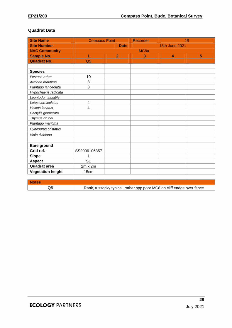
Site Name Compass Point Recorder JS
Site Number Date 15th June 2021
NVC Community MC8a
Sample No. 1 2 3 4 5
Quadrat No. Q5
Species
Festuca rubra 10
Armeria maritima 3
Plantago lanceolata 3
Hypochaeris radicata
Leontodon saxatile
Lotus corniculatus 4
Holcus lanatus 4
Dactylis glomerata
Thymus drucei
Plantago maritima
Cynosurus cristatus
Viola riviniana
Bare ground
Grid ref. SS2006106357
Slope 1
Aspect SE
Quadrat area 2m x 2m
Vegetation height 15cm
Notes
Q5 Rank, tussocky typical, rather spp poor MC8 on cliff endge over fence

EP21/203 Compass Point, Bude. Botanical Survey
30
July 2021
Site Name Compass Point Recorder JS
Site Number Date 15th June 2021
NVC Community MC8a - MC8d
Sample No. 1 2 3 4 5
Quadrat No. Q3 Q8
Species
Festuca rubra 9 9
Armeria maritima 1
Plantago lanceolata 4 2
Hypochaeris radicata 1 3
Leontodon saxatile 4
Lotus corniculatus 3 3
Holcus lanatus 3
Dactylis glomerata 3
Thymus drucei 4
Plantago maritima 2
Cynosurus cristatus 3
Viola riviniana 1
Bare ground
Grid ref. SS2008406348 SS2012606370
Slope 2
Aspect SE SE
Quadrat area 2m x 2m 2m x 2m
Vegetation height 20cm 5cm
Notes
Q3 plus Dactylis glomerata and Holcus lanatus, minus Agostis stolonifera
Q8
Short. Tight sward, less trampled intermediate between ranker vegetation and less maritime grassland toward fence

EP21/203 Compass Point, Bude. Botanical Survey
31
July 2021
Site Name Compass Point Recorder JS
Site Number Date 15th June 2021
NVC Community MC8g
Sample No. 1 2 3 4 5
Quadrat No. Q1 Q2
DOMIN
Species
Festuca rubra 7 9
Armeria maritima 8 5
Plantago lanceolata 3 5
Plantago coronopus 3
Hypochaeris radicata 3
Leontodon saxatile 3 3
Agrostis stolonifera 4 2
Trifolium repens 2 3
Cerastium sp 1
Lotus corniculatus 3
Holcus lanatus 1
Dactylis glomerata
Bellis perennis
Plantago maritima
Thymus praecox
Plantago maritima
Cynosurus cristatus
Viola riviniana
Bare ground
Grid ref. SS2005606342 SS2006706344
Slope 2 2
Aspect SE SE
Quadrat area 2m x 2m 2m x 2m
Vegetation height <5cm 10cm
Notes
Q1 MC8g Immediately south of tower
Q2
MC8g Less Armeria, more lush + Plantago lanceolata, - Plantago coronopus

EP21/203 Compass Point, Bude. Botanical Survey
32
July 2021
New Compass Point Recorder JS
Site Number Date 15th June 2021
NVC Community New area
Sample No. 1 2 3 4 5
Quadrat No. Q11 Q12 Q13 Q6 Q7
DOMIN
Species
Festuca rubra 9 9 6 10 9
Carex flacca 3 3 1 2
Holcus lanatus 4 2 3
Cynosurus cristatus 3 3
Lotus corniculatus 4 3 3 3 3
Ranunculus bulbosus 3 2 3
Plantago lanceolata 4 3 3 3 3
Achillea millefolium 3 1
Thymus drucei 3 5
Scilla verna 3 3
Succsia pratensis 1 1
Trifloium repens 3 3
Festuca ovina 3 3
Viola riviniana 4 4 4 6
Leontodon saxatile 4 3 3
Trifolium pratense 2
Potentilla erecta 2 3 3 2 1
Hypochaeris radicata 3 3
Agrostis stolonifera 8
Luzula campestris 1
Dactylis glomerata 3 3
Galium verum 3 3
Cirsium arvense 2
Agrostis capillaris 3
Bare ground
Grid ref. SS2016506331 SS2015406390 SS2015406390 SS2011406350 SS2014706572
Slope 1 1 1
Aspect N N SE
Quadrat area 2m x 2m 2m x 2m 2m x 2m 2m x 2m 2m x 2m
Vegetation height 5 <5 10 20cm 20cm
Notes
Q11 Quite spp rich c.12 paces from bench at proposed tower location
Q12 As Q11
Q13 Not overtly maritime
Q6 More rank grassland toward fence
Q7 Transitional to other less maritime grassland (probably MG1) beyond fence

EP21/203 Compass Point, Bude. Botanical Survey
33
July 2021
Site Name Compass Point Recorder JS
Site Number Date 15th June 2021
NVC Community MC8e
Sample No. 1 2 3 4 5
Quadrat No. Q4 Q9 Q10
DOMIN
Species
Festuca rubra 7 8 7
Plantago coronpus 8 6 6
Dactylis glomerata 3
Bellis perennis 1 1 4
P. maritima 6 5 4
P. lanceolata 1 3
Leontodon saxatile 3
Hypochaeris radicata 1
Bare ground 4 4 3
Grid Ref. SS2007506362 SS2009006363 SS2012606385
Slope
Aspect
Quadrat area 2m x 2m 2m x 2m 2m x 2m
Vegetation height 1cm 1cm 1cm
Notes
Trampled grassland along paths leading out to headland

EP21/203 Compass Point, Bude. Botanical Survey
34
July 2021
Site Name Compass Point Recorder JS
Site Number Date 15th June 2021
NVC Community H8a
Sample No. 1 2 3 4 5
Quadrat No. Q14 Q15
DOMIN
Species
Ulex gallii 7 9
Calluna vulgaris 4 3
Cuscuta epithymum 3
Potentilla erecta 3
Glechoma hederacea 3
Senecio jocobaea 2
Prunus spinosa 2
Dactylis glomerata 3
Thymus drucei 2
Carex binervis 3
Viola riviniana 2
Stachys officinalis 2
Ulex europaeus 3
Bare ground
Grid ref. SS2018606383 SS2018406394
Slope 1 3
Aspect N N
Quadrat area 2m x 2m 2m x 2m
Vegetation height 40cm 50cm
Notes
Q14 Wind pruned
Q15 Wind pruned, more exposed and further into stand - species poor