Borough of Deal - nj.gov · BOROUGH OF DEAL— STRATEGIC RECOVERY PLANNING REPORT PAGE I Executive...
48
Borough of Deal Strategic Recovery Planning Report
Transcript of Borough of Deal - nj.gov · BOROUGH OF DEAL— STRATEGIC RECOVERY PLANNING REPORT PAGE I Executive...

Borough of Deal
Strategic Recovery Planning Report

Borough of Deal Strategic Recovery Planning Report
DRAFT- August 15, 2014
Prepared by:
T&M Associates 11 Tindall Road
Middletown, NJ 07748
______________________ Stan Slachetka, PP, AICP NJ Professional Planner No.: 03508
The original of this document was signed and sealed in accordance with New Jersey Law.

BOROUGH OF DEAL— STRATEGIC RECOVERY PLANNING REPORT
PAGE I
Executive Summary When Superstorm Sandy struck the coast of New Jersey on October 29, 2012, it brought extensive damage to the Borough of Deal from both storm surge and wind damage. The Borough lost electricity service for 10 days. Other damages that the Borough sustained include the following: Damage beyond repair to two oceanfront homes; destruction of Conover Pavilion; washing away of the pier at the eastern end of Phillips Avenue; damage to eight private bulkheads and one municipal bulkhead; damage to seawalls and outfalls; damage to four beach access points; extensive erosion of the shoreline and damage to its dunes; damage to the Borough’s Sewage Pump House; and damage to the Deal Casino Beach Club. This list of Superstorm Sandy impacts that the Borough of Deal sustained is not exhaustive; the impacts are extensive and will be identified and discussed throughout this Strategic Recovery Planning Report.
Both in preparation for and in response to Superstorm Sandy, the Borough of Deal’s actions have been comprehensive. The Borough posted mandatory evacuations for residents living to the east of Ocean Avenue and broadcasted NIXLE messages keeping the community informed of the storm. In the days and weeks immediately following Superstorm Sandy, the Borough officials communicated and coordinated very well in order to provide recovery and response services to Borough residents. The Borough also deposited debris at a temporary management site located at the Deal Casino, including 6,099 cubic yards of vegetative debris and 1,287 of construction and demolition debris
In the weeks and months following Superstorm Sandy, the Borough of Deal has taken the following recovery actions (some of which are ongoing and continue to date): adopted FEMA Advisory Base Flood Elevations; provided assistance to residents in determination of base flood and flooding data; provided information to residents about County data and its website with mitigation plan information; contracted professionals to repair the pump station structure at 2 Roosevelt Avenue; repaired all damaged bulkheads; and completely rebuilt the Poplar Bridge, among other activities.
The Borough of Deal’s recommended actions to promote recovery from Superstorm Sandy and to reduce vulnerabilities from future storms include the following resiliency actions: updating the Borough’s Master Plan Elements; reevaluating and updating the Borough’s Emergency Operating Plan and Hazard Mitigation Plan; automating and updating the zoning and construction permit process; preparing a Capital Improvement Plan; preparing a Debris Management Plan; and developing a GIS database to support future planning efforts.

BOROUGH OF DEAL— STRATEGIC RECOVERY PLANNING REPORT
PAGE II
Acknowledgements
Mayor and Commission
Morris Ades, Mayor
Samuel M. Cohen, Borough Commissioner
Virginia S. Wiener, Borough Commissioner
Borough Officials
Stephen R. Carasia, Borough Clerk/Administrator
Michael W. Egan, Deputy Clerk
Joseph Hagerman, Department of Public Works Superintendent
Ronen Neuman, Chief of Police
Earl Alexander, Captain of Police
Jim Rogers, Special Projects Manager
Peter R. Avakian, P.E., Borough Engineer
T&M Associates Project Team:
Stan Slachetka, PP, AICP
Jeffrey Cucinotta
Stephanie McAlary

BOROUGH OF DEAL— STRATEGIC RECOVERY PLANNING REPORT
PAGE III
Table of Contents Introduction ............................................................................................................................................................................................................................ 1
Description of the Borough of Deal ................................................................................................................................................................................... 2
Assessment of Existing Planning Documents ................................................................................................................................................................... 5
Borough of Deal Master Plan, 1983 ............................................................................................................................................................................... 5
Master Plan Reexamination Report, 1999 ..................................................................................................................................................................... 5
Stormwater Management Plan, 2005 .............................................................................................................................................................................. 5
Flood Damage Prevention Ordinance, 2009, 2014 ...................................................................................................................................................... 6
Emergency Operating Plan, 2013 ................................................................................................................................................................................... 7
Monmouth County Growth Management Guide, 1982 .............................................................................................................................................. 7
Monmouth County Master Plan Draft, 2013 ................................................................................................................................................................ 9
Coastal Monmouth Plan, 2010 ...................................................................................................................................................................................... 10
Monmouth County Multi-Jurisdictional Natural Hazard Mitigation Plan, 2009, 2014 ........................................................................................ 11
Deal Lake Master Plan, 2013 ......................................................................................................................................................................................... 12
Coastal Area Facility Review Act (CAFRA) ................................................................................................................................................................ 13
Evaluation of Superstorm Sandy’s Impacts on the Borough of Deal .......................................................................................................................... 15
Damage to Homes .......................................................................................................................................................................................................... 20
Damage to the Conover Pavilion .................................................................................................................................................................................. 21
Damage to the Deal Casino Beach Club ..................................................................................................................................................................... 22

BOROUGH OF DEAL— STRATEGIC RECOVERY PLANNING REPORT
PAGE IV
Damage to the Sanitary Pump Station Site .................................................................................................................................................................. 24
Community Vulnerabilities Exacerbated by Superstorm Sandy ............................................................................................................................... 25
Community Opportunities Created by Superstorm Sandy ....................................................................................................................................... 25
Current Status of Post-Sandy Recovery Efforts .............................................................................................................................................................. 26
Beach Erosion Control Project ..................................................................................................................................................................................... 28
Improvements to the Roosevelt Avenue Pump Station Site .................................................................................................................................... 29
Improvements to Stormwater Infrastructure .............................................................................................................................................................. 30
Small Business Administration Disaster Loans .......................................................................................................................................................... 30
Community Outreach and Involvement ...................................................................................................................................................................... 30
Monmouth County Long Term Recovery Group ...................................................................................................................................................... 30
Rebuilding Approaches That Will be More Resistant to Damage from Future Storms....................................................................................... 31
Recommended Municipal Actions to Promote Recovery from Superstorm Sandy and to Reduce Vulnerabilities to Future Storms .............. 32
Summary of Actions and Priorities ................................................................................................................................................................................... 38
BOROUGH OF DEAL— STRATEGIC RECOVERY PLANNING REPORT
PAGE V
List of Figures Figure 1: Regional Location ................................................................................................................................................................................................. 3
Figure 2: Key Community Facilities and Preliminary Flood Insurance Rate Map (FIRM) ........................................................................................ 4
Figure 3: CAFRA Boundary ............................................................................................................................................................................................... 14
Figure 4: Damage at the Poplar Brook Bridge ................................................................................................................................................................ 15
Figure 5: Damage to the end of Roseld Avenue, Looking East ................................................................................................................................... 16
Figure 6: Damage to the end of Roseld Avenue, Looking West .................................................................................................................................. 16
Figure 7: The Deal Coastline (From the Border with Long Branch South to Phillips Avenue) Before and After Superstorm Sandy ............. 17
Figure 8: The Deal Coastline (From the Deal Casino South to Roseld Avenue) Before and After Superstorm Sandy ...................................... 18
Figure 9: The Deal Coastline (From Roseld Avenue South to the Border with Allenhurst) Before and After Superstorm Sandy ................... 19
Figure 10: Debris and Erosion of the Shoreline at 10 Roosevelt Avenue................................................................................................................... 20
Figure 11: The Destroyed Conover Pavilion ................................................................................................................................................................... 21
Figure 12: Flooding at the Conover Pavilion ................................................................................................................................................................... 21
Figure 13: Destruction of the Conover Pavilion Wooden Pier..................................................................................................................................... 22
Figure 14: Damage at the Conover Pavilion Snack Bar ................................................................................................................................................. 22
Figure 15: Damage at the Deal Casino (1 of 3) ............................................................................................................................................................... 23
Figure 16: Damage at the Deal Casino (2 of 3) ............................................................................................................................................................... 23
Figure 17: Damage at the Deal Casino (3 of 3) ............................................................................................................................................................... 23
Figure 18: A Concrete Wall at the Deal Casino that was Knocked Over ................................................................................................................... 23
Figure 19: Damage to the Pump Station Site (1 of 2) .................................................................................................................................................... 24
Figure 20: Damage to the Pump Station Site (2 of 2) .................................................................................................................................................... 24
Figure 21: Hazardous trees are removed post-Sandy. .................................................................................................................................................... 26

BOROUGH OF DEAL— STRATEGIC RECOVERY PLANNING REPORT
PAGE VI
Figure 22: Debris is placed at the Deal Casino parking lot............................................................................................................................................ 26
Figure 23: Debris is hauled away from the Deal Casino lot. ......................................................................................................................................... 27
Figure 24: Poplar Brook Bridge during Repairs .............................................................................................................................................................. 28
Figure 25: Repairs to the Pump Station Building’s Eastern Wall ................................................................................................................................. 29
List of Tables Table 1: Recommended Actions to Recover from Superstorm Sandy and to Improve Response and Increase Resiliency to Future Storms 33

BOROUGH OF DEAL— STRATEGIC RECOVERY PLANNING REPORT
PAGE 1
Introduction This Strategic Recovery Planning Report (SRPR) will serve as a blueprint to guide the Borough of Deal’s recovery from the effects of Superstorm Sandy and to reduce vulnerabilities to future storms. Accordingly, the report:
Evaluates the impacts on affected community features in Deal and addresses the conditions created or exacerbated by the storm;
Articulates the planning goals, strategies, and priority actions that are most urgently needed to improve public safety, increase resistance to damage from future storms, and stimulate economic recovery; and
Contains detailed descriptions of each of the projects proposed; a statement of need that demonstrates how each project relates to the impacts of Superstorm Sandy; why the project is important to the economic and environmental health of the community; the major tasks associated with each project; identification of potential or actual funding sources to pay for project implementation; and estimated implementation dates.

BOROUGH OF DEAL— STRATEGIC RECOVERY PLANNING REPORT
PAGE 2
Description of the Borough of Deal The Borough of Deal is located along the Atlantic Ocean in eastern Monmouth County. It is bordered to the north by Long Branch City, to the west by Ocean Township, to the south by Allenhurst Borough, and to the east by the Atlantic Ocean (as seen in Figure 1). The Borough has approximately 1.7 miles of coastline on the Atlantic Ocean, most of which is private access. A portion of Deal Lake borders the Borough of Deal to the southwest. The Borough also includes the Poplar Brook, which runs west to east through the Borough, until its outfall at the Atlantic Ocean just south of Roosevelt Avenue.
The Borough of Deal’s land area consists of approximately 1.2 square miles. The Borough is nearly fully developed and has very little land available for development (approximately 10% of the land area is devoted to open space use). Land use in Deal is mainly residential (approximately 81% of the land area) with single family homes being the predominant residential building type. In the Borough there is only one multi-family condo on the ocean front, and there is no potential for additional multi-family developments near the oceanfront. The remainder of the land area in Deal is devoted to commercial/mixed uses (about 9%).
According to the U.S. Census Bureau’s American Community Survey 2012 estimate, the Borough of Deal has a population of
934 and 376 households. In comparison, in the 2000 Census the Borough’s Population was 1,070 and in the 2010 Census it was 750. The population of the Borough increases to approximately 10,000 people during the summer months, as many homeowners and visitors capitalize on the Borough’s location on the Atlantic Coast.
Although the Borough of Deal is a coastal community, most of the Borough is located out of flood zones. However, the coastal area of the Borough is characterized by eroded beach. Significant erosion has necessitated construction of bulkheads to reduce risk to the remaining shoreline. Many of the groins that exist along Deal’s coastline are in disrepair due to impacts from constant wave action. Most of the Borough’s buildings are located outside of flood hazard areas, as seen in Figure 2. Figure 2 uses FEMA’s Preliminary Flood Insurance Rate Map (FIRM) data.
Furthermore, approximately 90 percent of the Borough’s land area is in the Coastal Area Facility Review Act (CAFRA) zone. The CAFRA zone applies to development projects near coastal waters, and generally the closer that an area is to the coast, the more heavily it is regulated by CAFRA. CAFRA regulates almost all development activities involved in residential, commercial, or industrial development, including construction, relocation, enlargement of buildings, excavation, grading, shore protection structures, and site preparation.

BOROUGH OF DEAL— STRATEGIC RECOVERY PLANNING REPORT
PAGE 3
Figure 1: Regional Location

BOROUGH OF DEAL— STRATEGIC RECOVERY PLANNING REPORT
PAGE 4
Figure 2: Key Community Facilities and Preliminary Flood Insurance Rate Map (FIRM)

BOROUGH OF DEAL— STRATEGIC RECOVERY PLANNING REPORT
PAGE 5
Assessment of Existing Planning Documents This SRPR will examine the adequacy of the Borough’s existing planning documents. More specifically, this section will describe the Borough of Deal’s planning needs and goals found in its various planning documents that relate to post-storm recovery and mitigation of future storm impacts.
Borough of Deal Master Plan, 1983 Upon the adoption of the 1983 Borough of Deal Master Plan, the Borough was already completely built-up and fully developed. The Plan outlined land use planning recommendations that at the time were meant to “simplify future development in harmony with existing patterns.”
One recommendation in this Plan was to consolidate the Borough’s previous ten zoning districts into five proposed districts. These five zoning districts currently remain in place and include Residential (R-1, R-2, R-3, and R-4), and Commercial (C) zones.
Another recommendation in the 1983 Plan was to limit development intensity and population density, as the Borough was already fully developed at the time. This is consistent with current planning objectives of the Borough that seek to limit the intensity of development, as stated in Borough ordinances and also in the Borough’s participation in the Monmouth County
Multi-Jurisdictional Natural Hazards Mitigation Plan, which will have an impact on stormwater infiltration.
In terms of population density, the Master Plan recommended that the Borough maintains its population density, subject to natural growth consistent with the land use proposals in the Plan.
Master Plan Reexamination Report, 1999 The 1999 Master Plan Reexamination Report was adopted by the Planning Board in November 1999. The Report notes that the Borough is fully developed and has no vacant lands available for potential development. No major zoning changes had occurred, only modifications to zoning district regulations. This Report also highlights the need to control over-development of residential lots in the Borough of Deal.
Stormwater Management Plan, 2005 This Plan identifies the following recommendations and goals:
Reduce flood damage, including damage to life and property.
Minimize, to the extent practical, any increase in stormwater runoff from any new development.
Reduce soil erosion from any development or construction project.
Assure the adequacy of existing and proposed culverts and bridges, and other in-stream structures.
Maintain groundwater recharge.

BOROUGH OF DEAL— STRATEGIC RECOVERY PLANNING REPORT
PAGE 6
Prevent, to the greatest extent feasible, an increase in nonpoint pollution.
Maintain the integrity of stream channels for their biological functions, as well as for drainage.
Minimize pollutants in stormwater runoff from new and existing development in order to restore, enhance, and maintain the chemical, physical, and biological integrity of the waters of the State, to protect public health, to safeguard fish and aquatic life and scenic and ecological values, and to enhance the domestic, municipal, recreational, industrial, and other uses of water.
Protect public safety through the proper design and operation of stormwater management basins.
Flood Damage Prevention Ordinance, 2009, 2014 This ordinance was first adopted in August of 2009 and was replaced in early 2014 with the Flood Prevention Ordinance recommended by the State of New Jersey, Department of Environmental Protection to ensure that it would be able to remain in effect if new mapping/ data was adopted in the future. The purpose of this ordinance is to promote the public health, safety, and general welfare, and to minimize public and private losses due to flood condition in specific areas by provisions designed:
To protect human life and health;
To minimize expenditure of public money for costly flood control projects;
To minimize the need for rescues and relief efforts associated with flooding and generally undertaken at the expense of the general public;
To minimize prolonged business interruptions;
To minimize damage to public facilities and utilities such as water and gas mains, electric, telephone and sewer lines, streets, bridges located in areas of special flood hazard;
To help maintain a stable tax base by providing for the second use and development of areas of special flood hazard so as to minimize future flood blight areas;
To ensure that potential buyers are notified that property is in an area of special flood hazard; and
To ensure that those who occupy the areas of special flood hazard assume responsibility for their actions
In order to accomplish its purposes, the Flood Damage Prevention Ordinance includes methods and provisions for reducing flood losses. This ordinance however, is not a complete Floodplain Management Plan and would not qualify for credit under the Community Rating System Program.

BOROUGH OF DEAL— STRATEGIC RECOVERY PLANNING REPORT
PAGE 7
Emergency Operating Plan, 2013 This manual, approved in 2013, sets forth the general policies and procedures to be carried out by municipal and volunteer entities (such as the Fire Department and EMS) in order to provide the citizens of the Borough with an effective integrated emergency response plan designed to minimize the loss of life and property during an emergency. The manual is comprised of the Basic Plan and the following accompanying annexes: Alerting, Warning, and Communications; Damage Assessment; Emergency Medical; Emergency Operations Center; Emergency Public Information; Evacuation; Fire and Rescue; Hazardous Materials; Law Enforcement; Public Health; Public Works; Radiological Protection; Resource Management; Shelter, Reception, and Care; Social Services; and Terrorism Incident Annex.
The purpose of the Emergency Operations Basic Plan is to protect life and property in emergencies by coordinating response activities of municipal and volunteer entities to ensure their optimum use. It provides for actions to be taken to mitigate, prepare for, respond to, and recover from the effects of an emergency. The plan is an “all-hazards” approach to emergency management and covers natural disasters, technological disasters, and national security crises.
Monmouth County Growth Management Guide, 1982 The Growth Management Guide (GMG) is the main planning tool used in Monmouth County. In 1982 it was adopted as the
Monmouth County Master Plan. The GMG is intended to be a framework for other planning and decision making, and is a point of departure and a catalyst for an ongoing dialogue between the County and its municipalities.
The Guide categorizes the Borough of Deal as primarily a Suburban Settlement Growth Area, while the Borough’s frontage on the Atlantic Ocean is located in both the Proposed Protection Area and the Environmentally Sensitive Area.
Suburban Settlement policies in this plan include:
Encourage a variety of residential types in the suburban settlement.
Encourage the use of the neighborhood unit in the suburban settlement.
Encourage the use of cluster development in all parts of the county.
Proposed Protection Area policies in this plan include:
Encourage public acquisition of unique freshwater wetlands for conservation and groundwater recharge.
Continue the policy or supporting a county-wide system of linear greenbelts along primary and secondary streams.
Encourage public acquisition of lands that are geologically unstable and unsuitable for development.
Environmentally Sensitive Area policies in this plan include:

BOROUGH OF DEAL— STRATEGIC RECOVERY PLANNING REPORT
PAGE 8
Restrict non-water related development in coastal flooding and high-risk erosion areas.
Establish a coastal development district to set density, location, and use standards for areas adjacent to the Atlantic Ocean and the Sandy Hook and Raritan Bays.
Prohibit high-rise structures from all areas east of the first public roadway from the Bay and discourage structures within 1,000 feet of the Bay shoreline.
Allow for oceanfront development of beach-related commercial and recreational activities where such uses have been traditionally located.
Encourage new coastal development compatible with the surrounding environment.
Continue to protect tidal wetlands through state and federal wetlands management programs.
Encourage municipalities to adopt ordinances providing for the protection and conservation of freshwater wetlands.
Encourage municipalities to adopt and enforce floodplain ordinances to protect life and property against floodwaters, and to protect floodplains from development.
In 1995, the Monmouth County Planning Board adopted the Goals, Objectives, and Policies as an element of the GMG. Goals of the GMG relevant to this SRPR include the following:
Air Resources: To promote land use planning that encourages the use of transit, walking and cycling, and the
creation of centers in order to improve air quality by reducing automobile trips and congestion.
Centers: To promote new and revitalize older urban areas into well designed mixed use centers with an easily accessible compact but varied core of residential, commercial, and community services which provide employment and create a specific identity.
Comprehensive Planning: To promote comprehensive planning among all levels of government as well as the private sector by sharing information and developing a continuing dialogue on regulations, plans, policies, and issues.
Economic Development: To promote managed growth by providing a suitable long-term economic climate and preserving and enhancing the quality of life in Monmouth County for the attraction of new businesses and the retention of existing businesses.
Historic, Cultural, Natural, and Scenic Resources: To preserve the valuable historic, cultural, natural, and scenic resources of Monmouth County.
Housing: To provide housing opportunities for all residents of Monmouth County.
Transportation: To plan for a comprehensive and reliable intermodal transportation system that properly provides for public safety and meets the needs of the County’s workers, residents, and visitors as well as respects the environment.

BOROUGH OF DEAL— STRATEGIC RECOVERY PLANNING REPORT
PAGE 9
Water Resources: To provide all of Monmouth County with a safe and pollution-free water environment, and conserve valuable water-oriented resources.
Monmouth County Master Plan Draft, 2013 The Monmouth County Planning Board is in the process of undergoing a comprehensive update to the County Master Plan, with drafts of its vision statement as well as goals, principles, and objectives available on the Monmouth County Division of Planning website.
The Plan’s draft principles that are relevant to this SRPR include the following:
Comprehensive Planning: Planning issues are to be addressed from interdisciplinary perspectives to identify and assess both interdependent and collective impacts and opportunities. This will minimize adverse impacts while maximizing benefits for all parties.
Coordination: Effectual planning requires integration and coordination both internally (horizontally) and with other levels of government (vertically).
Approach: Comprehensive planning relies on the use of new and emerging technologies as well as traditional methods of input from stakeholders and citizens.
Natural Resources: Natural resources are life supporting infrastructure that all human and built environments are dependent upon to function and prosper.
Investments in Preservation Areas: Aligning state, local, and county preservation strategies improves efficiency and reduces cost in protecting natural and unique resources.
Preservation of Community Character: Protect and strengthen the established character of municipalities and their unique, individual qualities.
Recovery and Community Resiliency: Promote planning, land use, and design strategies that increase the capacity to adapt physically and economically to long-term environmental changes and natural hazards. – Objectives:
Participate in long-term recovery, mitigation, and resiliency efforts to better protect people, businesses, and resources against environmental damage and natural disasters.
Assist in the coordination of the County’s long-term disaster recovery planning initiatives.
Provide assistance to other County agencies involved in disaster response and emergency management.
Provide technical assistance to municipalities in disaster recovery efforts.
Investment in Growth Areas: Aligning state, local, and county investment strategies improves efficiency and reduces cost in repairing, and expanding systemic infrastructure.

BOROUGH OF DEAL— STRATEGIC RECOVERY PLANNING REPORT
PAGE 10
The Plan will be a vital coordinating tool used by municipalities, school boards, businesses, and other government agencies to help guide efforts and actions that contribute to a strong, stable, and sustainable prosperity for those that call Monmouth County home.
Coastal Monmouth Plan, 2010 The Coastal Monmouth Plan was initiated by the Monmouth County Planning Board to construct a plan for the future development of natural resource conservation of the County’s Atlantic coastal region, which includes the Borough of Deal and 29 other municipalities.
The Plan’s goal is: To create a vision and planning strategy for the Coastal Monmouth Region (CMR) to cooperatively address development issues on a regional scale in a manner that is sensitive to the area’s unique coastal setting, diverse community character and critical environmental, cultural, and aesthetic resources.
The Plan was also developed with the following objectives:
To preserve and enhance the character and quality of life in the CMR.
To identify and assess current and future land use, economic development, public services, transportation, and design issues within the CMR.
To identify development, redevelopment, and revitalization opportunities within the CMR.
To identify and address conservation strategies to aid in the preservation, protection, and accessibility to the region’s sensitive environmental, cultural, and aesthetic resources.
To identify and asses transportation strategies that provide safe, efficient, and enhanced multimodal mobility for the CMR.
To identify and assess public infrastructure (water, sewer, schools) capacities to ensure sustainable development within the region.
To identify and assess community design strategies that will provide alternative models to address specific design issues identified in the CMR.
To identify and assess regional mechanisms that will encourage regional cooperation to address multi-municipal concerns.
To cooperatively prepare a regional plan for submittal to the State Planning Commission for Plan Endorsement.
Monmouth County’s engagement with the Borough of Deal (including through the public visioning process) took place in 2007 and identified some planning priorities for the Borough as it relates to the Coastal Monmouth Region. This planning process identified the following:
The Borough’s long-term vision is to maintain its present residential character.
The top planning issues included:

BOROUGH OF DEAL— STRATEGIC RECOVERY PLANNING REPORT
PAGE 11
o Maintaining the Borough’s present residential character; and
o Accommodating dramatic seasonal changes in population.
The Borough identified no redevelopment/revitalization needs.
Active conservation projects included: o Working with the US Army Corps of Engineers
Beach Replenishment Program; o Working with FEMA regarding flooding issues; o Maintaining impervious surface coverage limits to
reduce runoff; and o Maintaining a recycling program.
Transportation concerns included: o Signalizing the intersection of Phillips and Route
71 (has since been completed), o Implement a bicycle-only lane on Ocean Avenue
to facilitate local pedestrian/bicycle accessibility and safety (has since been completed),
Goals regarding infrastructure include: o Adequate water and sewer capacity for current
and future demand; o Upgrading sanitary sewer lines to reduce
infiltration; and o Completing the upgrade on municipal pumping
station.
The Borough also identified as a design concept concern the need to develop standards for building heights and setbacks.
Monmouth County Multi-Jurisdictional Natural Hazard Mitigation Plan, 2009, 2014 The Monmouth County Multi-Jurisdictional Natural Hazard Mitigation Plan (HMP) was adopted in 2009 to meet the requirements of the Disaster Mitigation Act (DMA) of 2000. The HMP’s development was led by the County and was funded through a FEMA planning grant. Monmouth County employed a multi-jurisdictional approach to develop the plan, and every municipality in the County was invited to participate as an equal partner with the County.
The HMP represents the collective efforts of citizens, elected and appointed government officials, business leaders, volunteers of non-profit organizations, and other stakeholders. It identifies natural hazards that could affect the County’s jurisdictions, evaluates the risks associated with these hazards, identifies the mitigation actions to lessen the impacts of a disaster on Monmouth County communities, and prioritizes them based on the municipal master plans and other planning documents.
The successful implementation of the HMP will result in an increasingly resilient Monmouth County. In addition, the HMP ensures that Monmouth County and its jurisdictions are compliant with the Disaster Mitigation Act of 2000 (DMA),

BOROUGH OF DEAL— STRATEGIC RECOVERY PLANNING REPORT
PAGE 12
which makes the County and its jurisdictions eligible to apply for Federal aid for technical assistance and post-disaster hazard mitigation project funding.
To remain compliant with the DMA, the HMP must be updated every five years. The County is currently undertaking a comprehensive update of the HMP, with a draft expected to be completed in 2014. The FEMA approval and jurisdictional adoptions of the updated plan are anticipated thereafter. The Borough of Deal is actively participating in the update process and has provided progress reports to the County regarding mitigation and resiliency measures undertaken since the HMP’s adoption in 2009.
As part of its participation in the HMP update process, The Borough of Deal noted that Superstorm Sandy has shifted most attention to rebuilding and reinforcing the beachfront areas that were so dramatically impacted. In addition, two municipal mitigation priority actions that were identified in the 2009 HMP have been updated by the Borough, as follows:
Action 1: Set up a detention pond and berm system to prevent future flooding for Poplar Brook between Norwood Avenue and Ocean Avenue. On this task, some work has been done in both Deal and upstream in Ocean Township, which has improved the situation. The berm system and retention pond has been determined by engineers not to be a benefit and has been abandoned.
Action 2: Widen culverts under roadways in three different streets for Poplar Brook (Norwood Avenue,
Almyr Avenue, and Ocean Avenue). Ocean Avenue has been completed. Almyr Avenue is owned by the County and Norwood Avenue is owned by the State, so no funding has been provided yet and no work has been completed. The Borough will keep these two locations pending for possible future completion.
Deal Lake Master Plan, 2013 In addition to the Municipal and County plans that guide development in the Borough of Deal, the Borough is also a part of the Deal Lake Commission. This is because the southern half of the Borough is located in the Deal Lake drainage basin, as approximately 1,800 feet of land in the Borough of Deal fronts on a portion of the Deal Lake.
The Deal Lake Commission’s Master Plan focuses on solving the problems of Deal Lake, its tributaries, and its 4,400 acre watershed. The Plan highlights important issues for the watershed area, including the following: New Jersey Department of Environmental Protection restrictions and permitting issues, dredge material disposal solutions, storm water management, and storm drain issues, among others.

BOROUGH OF DEAL— STRATEGIC RECOVERY PLANNING REPORT
PAGE 13
Coastal Area Facility Review Act (CAFRA) Coastal Area Facility Review Act (CAFRA) regulations apply to development activities near coastal waters. Generally, the closer the project is to the water, the more likely it will be regulated. The CAFRA law regulates almost all development activities involved in residential, commercial, or industrial development, including construction, relocation and enlargement of buildings, excavation, grading, shore protection structures, and site preparation.
Approximately 90% of the Borough of Deal’s land area is located within the coastal zone boundaries. This includes all land located to the east of the New Jersey Transit North Jersey Coast Line. Any regulated development within the CAFRA area requires a CAFRA permit. In the Borough of Deal, as well as areas in other municipalities located within the CAFRA boundary, development is regulated and therefore a permit shall be required for:
Any development on a beach or dune
Any development located in the CAFRA area between the mean high water line of any tidal waters, or the landward limit of a beach or dune, whichever is most landward, and a point 150 feet landward. This includes single family homes, commercial, industrial, and public development.
Residential development within the CAFRA area has varying regulation depending on how many dwelling units it has and the development’s location in relation to the mean high water line.
Commercial development within the CAFRA area has varying degrees of regulation depending on the number of parking spaces and the development’s location in relation to the mean high water line.
Furthermore, CAFRA separates the coastal region into zones and centers where development is regulated by varying degrees. The Borough is located within the Coastal Metropolitan Planning Area. This area within the CAFRA boundary guides development and redevelopment to ensure efficient use of scarce land while capitalizing on the inherent public facility and service efficiencies of concentrated development patterns.

BOROUGH OF DEAL— STRATEGIC RECOVERY PLANNING REPORT
PAGE 14
Figure 3: CAFRA Boundary

BOROUGH OF DEAL— STRATEGIC RECOVERY PLANNING REPORT
PAGE 15
Evaluation of Superstorm Sandy’s Impacts on the Borough of Deal Superstorm Sandy brought high winds, heavy rains, and a record tidal surge and waves to the Borough of Deal. Inundation was less of a problem to the Borough in general due to the existing high ground. Impacts on Deal include (but are not limited to) the following:
Loss of electricity service for 10 days;
Damage beyond repair to two oceanfront homes that were subsequently demolished;
Destruction of Conover Pavilion and its pier;
Damage to eight private bulkheads and one municipal bulkhead;
Damage to seawalls and outfalls;
Damage to four beach access points (Roosevelt Avenue, Darlington Road, Deal Esplanade, and Phillips Avenue);
Extensive erosion to the shoreline (as seen in Figures 7, 8, and 9);
Damage to dunes, including 36,000 cubic yards of sand;
A washed-out revetment at the south end of the Deal Casino Beach Club;
Damage to the Borough’s Sewage Pump House located at 2 Roosevelt Avenue;
Forced evacuation of Borough residents residing to the east of Ocean Avenue;
The Police Department’s firearms qualification range was completely destroyed and has not yet been rebuilt;
Damage to the bridge at Poplar Brook; and
Roads across the Borough were covered in debris following the storm, but they did not sustain damage. However, the roadway at the eastern end of Roseld Avenue had collapsed as a result of the storm and had to be repaired.
Figure 4: Damage at the Poplar Brook Bridge

BOROUGH OF DEAL— STRATEGIC RECOVERY PLANNING REPORT
PAGE 16
Figure 5: Damage to the end of Roseld Avenue, Looking East
Figure 6: Damage to the end of Roseld Avenue, Looking West

BOROUGH OF DEAL— STRATEGIC RECOVERY PLANNING REPORT
PAGE 17
Figure 7: The Deal Coastline (From the Border with Long Branch South to Phillips Avenue) Before and After Superstorm Sandy

BOROUGH OF DEAL— STRATEGIC RECOVERY PLANNING REPORT
PAGE 18
Figure 8: The Deal Coastline (From the Deal Casino South to Roseld Avenue) Before and After Superstorm Sandy

BOROUGH OF DEAL— STRATEGIC RECOVERY PLANNING REPORT
PAGE 19
Figure 9: The Deal Coastline (From Roseld Avenue South to the Border with Allenhurst) Before and After Superstorm Sandy

BOROUGH OF DEAL— STRATEGIC RECOVERY PLANNING REPORT
PAGE 20
Damage to Homes As a result of the destruction and damages from Superstorm Sandy, the Borough of Deal faces a significant financial burden. The Borough as a whole has sustained a 0.2% loss in home values and tax revenue, a $3,836,300 reduction in assessment from 2012 to 2013 as a result of Superstorm Sandy. 12 properties faced reduced property values.
In particular, the residence located at 9 Monmouth Terrace faced extensive damage to the rear of the property along the waterfront. 17 Monmouth Terrace sustained damages to the extent that it had to be demolished, and the lot still has not been redeveloped. In addition, 8 Neptune Avenue also was demolished, resulting from storm damage, and also remains undeveloped.
In the months following Superstorm Sandy, the New Jersey Department of Community Affairs compared 2011 American Community Survey 5-Year Survey Data and FEMA Individual Assistance Data (effective March 12, 2013) with observed storm-related damage in order to identify damages and to determine the most efficient use of Community Development Block Grant Disaster Recovery (CDBG-DR) funds. This effort resulted in the completion of a Statewide CDBG Disaster Recovery Action Plan.
The CDBG Disaster Recovery Action Plan identifies one census tract in the Borough of Deal (census tract 34025812400) where homes sustained “severe” or “major” damage according to classifications made by HUD. This does not include dwelling
units that sustained minor damage, which was far more common. The median household income in this census tract is $99,545. This census tract has 1,058 households, and 2% of these households faced severe or major damage.
Figure 10: Debris and Erosion of the Shoreline at 10 Roosevelt Avenue.

BOROUGH OF DEAL— STRATEGIC RECOVERY PLANNING REPORT
PAGE 21
Damage to the Conover Pavilion The Conover Beach area sustained damages from Superstorm Sandy as well. The W. Stanly Conover Pavilion, a public beachfront located at 125 Ocean Avenue, was destroyed by the storm surge. The Pavilion was an all wood construction complex that was built in 1933 with two additions dating back to the 1960s. It provided individual changing rooms, showers, lockers, bathrooms, a snack bar, a sun bathing courtyard, and two ocean view front covered sitting areas. The entire complex sat on a wooden deck floor, elevated above the beach by wooded piles.
During Superstorm Sandy, the facility was shifted off of its pilings and had its structural system severely damaged, and this included two clusters of one-story frame buildings that house changing areas lockers, and a refreshment stand. The complete list of destruction and damages to the facility has been outlined by the Borough in its FEMA Project Worksheet. Some of the destruction to the pavilion includes (but is not limited to) the following: wooden foundation piles; building sewer pipe public street connections; deck flooring; shingles; roofing; doors; windows; counter tops; lockers; various kitchen equipment and appliances; plumbing throughout the facility; water heaters; a swing set; and numerous tables and chairs.
In addition to the aforementioned damages, the pavilion also posed a threat to public health and safety during the aftermath of the storm, as the yellow and white siding/panels on the outside of the destroyed structure contained asbestos.
Figure 11: The Destroyed Conover Pavilion
Figure 12: Flooding at the Conover Pavilion

BOROUGH OF DEAL— STRATEGIC RECOVERY PLANNING REPORT
PAGE 22
Figure 13: Destruction of the Conover Pavilion Wooden Pier
Figure 14: Damage at the Conover Pavilion Snack Bar
Damage to the Deal Casino Beach Club The Casino Beach Club is a beachfront property that originated in 1957, with additions in 1972 and 1977. The Club is a recreational built-up complex of single-story, wood-framed buildings, which house a casino administration office, changing rooms and showers, a salt water swimming pool, snack bars, and ancillary facility storage.
Superstorm Sandy’s surge removed sand from the beach, washing out the underground water lines and electrical conduit for the portable beach cabanas. In addition, the club originally had a three-foot built-up stone wall that separated the complex from the beach area. The storm surge reached over the stone wall, completely destroying the galvanized fence and snow fence that surrounds the Casino beach area, flooding the complex, and depositing sand residue throughout the grounds (including in the sea water swimming pool).
Superstorm Sandy’s winds removed roofing off of a number of the buildings at the facility. An entire roof was removed from one building and collapsed onto an adjacent building, damaging much of the wall structure on that side of the building.

BOROUGH OF DEAL— STRATEGIC RECOVERY PLANNING REPORT
PAGE 23
Figure 15: Damage at the Deal Casino (1 of 3)
Figure 16: Damage at the Deal Casino (2 of 3)
Figure 17: Damage at the Deal Casino (3 of 3)
Figure 18: A Concrete Wall at the Deal Casino that was
Knocked Over

BOROUGH OF DEAL— STRATEGIC RECOVERY PLANNING REPORT
PAGE 24
Damage to the Sanitary Pump Station Site This structure is located at 2 Roosevelt Avenue, at the eastern end of the street along the Atlantic Coast. The pump station was constructed in 1929. It was established in the Borough’s low line area to provide gravity sewer service to the entire municipality. Prior to Superstorm Sandy’s landfall, this sanitary pump station served 1,173 residential units, 59 businesses with 457 employees, 1 elementary school, and 5 churches/houses of worship. Due to the site’s location and proximity to the Atlantic Ocean, the revetment was established during the construction of the pump station to protect it from storm damage.
The facility building is composed of a single story structure above grade with two sublevels of basement below the building. Superstorm Sandy’s storm surge and waves destroyed the protective wall, and floodwaters completely inundated the lowest subbasement level. The water level on the first basement sublevel was approximately five to six feet deep.
During Superstorm Sandy, the unprotected section of the shoreline was breached and eroded away from storm surge, winds, and wave action. This caused approximately $1,426,167.28 in damage to the shoreline and the sanitary pump station.
Identified damages to the pump station building occurred to the following: the roof; the reinforced concrete eastern wall; the entrance hall; the bathroom; the control room; the generator room; the furnace room; two offices; and the main hall.
Damages that occurred to the sewage lift station system’s equipment include the following: one HVAC unit; four submersible pumps; one control panel; 12 different types of valves; four variable frequency drives; one flow meter transmitter; one flow chart recorder; and one generator and other associated components.
Figure 19: Damage to the Pump Station Site (1 of 2)
Figure 20: Damage to the Pump Station Site (2 of 2)

BOROUGH OF DEAL— STRATEGIC RECOVERY PLANNING REPORT
PAGE 25
Community Vulnerabilities Exacerbated by Superstorm Sandy Superstorm Sandy exacerbated the vulnerability of homeowners and business owners in the following ways:
The loss of fuel exposed residents to the dangers of cold fall nights;
The loss of power and cell phone service impacted the communication between emergency personnel;
Regular moon tide inundation has increased as a result of stream siltation from Superstorm Sandy;
Beach and dune erosion resulted in an immediate threat of additional damage or destruction to improved property and the general public in the vicinity of the coastline;
Oceanfront private properties face beach erosion;
Residential properties along the Poplar Brook are affected by flooding and bank overflow caused by runoff from severe rain. Although damage from Superstorm Sandy was mostly related to storm surge, if a future storm were to bring high rains and storm surge to the Borough, the area along the Poplar Brook would at risk; and
Loss of service of sanitary pump station for 18 months caused health risks. While no one has killed or become deathly ill from the sanitary pump station being offline, the fact remains that non-sanitary conditions pose a direct health concern for the immediate municipality, as well as for surrounding hospitals and residents within the adjoining area.
Community Opportunities Created by Superstorm Sandy The impacts of Superstorm Sandy have shed light on the ways in which the Beach of Deal may improve its resiliency in future storm events. As such, the Borough may improve its resiliency by implementing the following opportunities that have been created:
Promoting public awareness of hazard mitigation and resiliency issues;
Focusing public agencies on community vulnerabilities to hazards such as flooding;
Encouraging regional solutions to flood- and storm-related impacts;
Ensuring that future capital projects are designed and constructed to incorporate features that are resilient to storm- and flood-related impacts;
Encouraging/supporting the use of sustainable development techniques and green building design in future development and redevelopment; and
Improving the water flow at Poplar Brook, and in general drainage throughout the Borough.

BOROUGH OF DEAL— STRATEGIC RECOVERY PLANNING REPORT
PAGE 26
Current Status of Post-Sandy Recovery Efforts Both in preparation for and in immediate response to Superstorm Sandy, the Borough of Deal took the following emergency protective measures:
Issued mandatory evacuations for homes to the east of Ocean Avenue;
Broadcasted NIXLE messages keeping the community informed of the status of the storm;
Police officers and the Department of Public Works personnel communicated and coordinated very well in order to provide recovery and response services to Borough residents;
Deposited debris at a temporary management site located at the Deal Casino, amounting to approximately 6,099 cubic yards of vegetative debris, 1,287 cubic yards of construction and demolition debris, which was later hauled to the Monmouth County Landfill for final disposal;
Removed nine hazardous leaning trees greater than six inches and deposited them in the temporary debris site at the Deal Casino; and
Loaded and transported 259.51 tons of additional construction and demolition debris to the Ocean County Landfill.
Figure 21: Hazardous trees are removed post-Sandy.
Figure 22: Debris is placed at the Deal Casino parking lot.

BOROUGH OF DEAL— STRATEGIC RECOVERY PLANNING REPORT
PAGE 27
Figure 23: Debris is hauled away from the Deal Casino lot.
In the weeks and months following Superstorm Sandy, the Borough of Deal has taken (and continues to take) the following recovery actions:
Provided assistance to residents in determination of base flood and flooding data;
Provided information to residents about County data and its website with mitigation plan information;
Provided a temporary bathroom facility for beach patrons at the Conover Beach Pavilion as it underwent improvements;
Hired North American pipeline Services LLC to use a clean jet pumping system to remove flood water and waste from the wet well to gain access to the main sewer line coming into the pump station structure;
Contracted construction, architecture, and engineering services to repair the pump station structure at 2 Roosevelt Avenue. Although the public (fishing) access at this location has not been restored to date;
Repaired all damaged bulkheads;
Completely rebuilt the Poplar Brook Bridge (near 60 Ocean Avenue);
Repaired the roadway at the eastern end of Roseld Ave.;
Secured an insulation company to remove and dispose of an estimated 5,400 square feet of the hazardous asbestos from the W. Stanley Conover Pavilion;
Passed Ordinance 1084 on February 7, 2014 amending Chapter XIX Flood Damage Prevention, which adopted FEMA Advisory Base Flood Elevations; and
Passed additional ordinances and resolutions in order to: o Require all future oceanfront constructed homes
and new construction along Poplar Brook to build the residence at a certain elevation above seawater; and
o Require newly constructed homes to have electric run underground in order to reduce the number of fallen power lines during a storm.

BOROUGH OF DEAL— STRATEGIC RECOVERY PLANNING REPORT
PAGE 28
Figure 24: Poplar Brook Bridge during Repairs
Beach Erosion Control Project In February of 2014, U.S. Army Corps of Engineers (USACE), in partnership with the New Jersey Department of Environmental Protection (NJDEP), released a draft Hurricane Sandy Limited Reevaluation Report (HSLRR). This is an erosion control project, spanning from the Elberon neighborhood in Long Branch southward along the coastline of Deal, Allenhurst, and Loch Arbour. The Elberon to Loch Arbour Reach is approximately 3.5 miles in length along the Atlantic Coast. A lack of public access has stalled this process in the past.
Planning objectives of the study include the following:
Reduce the threat of potential future damages due to the effects of storms, with an emphasis on inundation, wave impacts, and shoreline recession.
Manage the risk of the long term erosion that is currently experienced.
Provide an economically justified plan.
Preserve and maintain existing environmental resources and habitats to fish and wildlife, where possible.
Preserve cultural resources within the project area.
The HSLRR recommends constructing a 100 foot wide beach berm, consisting of approximately 4,450,000 cubic yards of sand. In addition, six existing groins will be modified in order to allow sediment to pass through, and 16 existing outfalls will be modified as a result of the beach berm construction. The proposed beach berm will be constructed on existing beachfront property that is privately owned, as well as public properties owed by Long Branch, Deal, Allenhurst, Loch Arbour, Asbury Park, and the State of New Jersey. Construction is scheduled to begin in October of 2014 and to be completed in November of 2015.

BOROUGH OF DEAL— STRATEGIC RECOVERY PLANNING REPORT
PAGE 29
Improvements to the Roosevelt Avenue Pump Station Site The pump station has been offline since sustaining damages from Superstorm Sandy. In May of 2014 the Borough of Deal submitted a Hazard Mitigation Grant Program application to fund recovery and protection of the site. The Borough has proposed to mitigate the southern shoreline of the site that was eroded during Superstorm Sandy.
In addition, the stone revetment will be constructed to increase protection by providing approximately 90 linear feet of shoreline protection. The shoreline area was the remaining beach area unprotected by stone. The wall will be approximately 35 feet wide by 19 feet in height. A ten foot top width will be provided to establish a flat surface area to provide better access for future maintenance as necessary.
In addition to the proposed stone revetment, the entire revetment system will be raised to an elevation of 20.4 feet. The proposed stone revetment will join the adjoining properties to provide one complete system.
This project will mitigate natural and hydrologic risks, including extreme wind, hurricanes and tropical storms, nor’easters, coastal erosion, flood, storm surge, and wave action. The Borough of Deal anticipates this project will be completed by May 2016.
Figure 25: Repairs to the Pump Station Building’s Eastern Wall
BOROUGH OF DEAL— STRATEGIC RECOVERY PLANNING REPORT
PAGE 30
Improvements to Stormwater Infrastructure The Borough of Deal has applied for a FEMA grant to fund stormwater infrastructure and drainage improvements along the Brighton Avenue and Marine Place outfalls. The capacity of the system is extremely limited and does not meet the current NJDOT standards. The two stormwater infrastructure systems serve 263 residential units, four businesses, two critical municipal structures (the Deal Fire Company No. 2 and the Deal First Aid Squad), and St. Mary’s Church.
The proposed stormwater infrastructure improvements will be constructed to increase protection by providing approximately 6,000 linear feet of drainage mitigation and increasing the storm sewer size. This work will provide a safe transfer of stormwater from the roadways to the piped stormwater system.
Small Business Administration Disaster Loans In the months following Superstorm Sandy, the Small Business Administration (SBA) has been issuing loans to homeowners and businesses in New Jersey to aid in their recovery and reconstruction efforts. NJ.com has compiled data from the SBA and made it available on their website. The Borough of Deal received two loans for protective measures totaling $164,328.
Community Outreach and Involvement As part of its effort to provide community involvement opportunities to Borough residents in its response to and recovery from Superstorm Sandy, The Borough of Deal will hold a public hearing before the Borough Commission on August 22, 2014. This will include discussion with residents of the Borough on inputs for this SRPR.
Monmouth County Long Term Recovery Group The Monmouth County Long Term Recovery Group (MCLTRG) seeks to assist all Monmouth County residents and homeowners in recovery from disasters by addressing and prioritizing unmet needs.
MCLTRG’s priorities include:
Individuals and families who: need assistance to maintain or obtain safe, sanitary, and secure housing; are not served, or who are underserved, by other existing aid programs, including those who are ineligible for FEMA; are experiencing economic hardship in pursuing a plan for recovery; are isolated or have difficulty accessing services; have begun the recovery process but have encountered a setback and need assistance with their continued recovery; and need assistance in order to prevent deterioration in their continued recovery.
Landlords of owner-occupied residential rental property of four units or less (or non-owner occupied residential rental property of three tenants or less) where assistance
BOROUGH OF DEAL— STRATEGIC RECOVERY PLANNING REPORT
PAGE 31
will provide safe, sanitary, and secure housing that will be affordable and permanent for the owner-occupant and residential tenants.
In October of 2013, the American Red Cross awarded a grant to the MCLTRG in the amount of $1.1 million. With this grant, the MCLTRG plans to prioritize 150 Monmouth County residents who have exhausted other available resources, but still face unmet needs in terms of home repair and rebuilding assistance. As of August 2013, the Red Cross had received $308 million in donations for its Hurricane Sandy emergency relief and recovery efforts, with $272 million spent or committed.
There is no publicly available data regarding MCLTRG’s recovery aid in the Borough of Deal, but aid from this group remains available for Borough residents.
A Monmouth County resident seeking support from this MCLTRG must submit an intake form, will be assigned a case manager, and will be designated to a tier level of need according to MCLTRG priorities. From there, the case manager will review the intake, contact the client where necessary, and establish the range of services available.
Rebuilding Approaches That Will be More Resistant to Damage from Future Storms The recovery efforts previously mentioned all serve as rebuilding approaches that the Borough of Deal is taking to be more resilient in the future. They serve to protect residents from the dangers of potential storm events by providing a solution to damaged services.
The Borough also requests a stormwater management component to accompany each site plan application, when residential properties apply for pools, basketball courts, tennis courts, recreation facilities, or other accessory structures. Furthermore, the Borough enforces a 40% impervious coverage restriction on development to support its efforts to protect wet lands, streams, lakes, and ocean front through zoning regulations.
In addition to the aforementioned recovery and rebuilding efforts, the Borough of Deal may also consider the following:
Rebuilding and renovating homes and structures in accordance with flood hazard and construction codes.
Elevating key community facilities above the base flood elevation.
Educating residents and builders about flood hazards and flood-resistant provisions in codes.
Protecting natural areas that currently buffer developed areas from storm damage and storm surge.
Improving drainage throughout the Borough.
Completing beach replenishment projects.

BOROUGH OF DEAL— STRATEGIC RECOVERY PLANNING REPORT
PAGE 32
Recommended Municipal Actions to Promote Recovery from Superstorm Sandy and to Reduce Vulnerabilities to Future Storms This Strategic Recovery Planning Report recommends that the Borough of Deal promote recovery from Superstorm Sandy and resiliency to future hurricanes and storms by taking the actions that are detailed in Table 1 below. These actions have been developed in consultation with the officials from a variety of Borough offices, and are intended to promote recovery from Superstorm Sandy and resiliency to future hurricanes and storms. They are classified in order of priority, where short-term priority means that the particular action should be implemented within 12 months, mid-term priority within 24 months, and long-term priority within 36 months. The prioritization could shift depending on available funding. Actual costs of each project will be prepared at the time that the specific scope of work is determined.

BOROUGH OF DEAL— STRATEGIC RECOVERY PLANNING REPORT
PAGE 33
Table 1: Recommended Actions to Recover from Superstorm Sandy and to Improve Response and Increase Resiliency to Future Storms
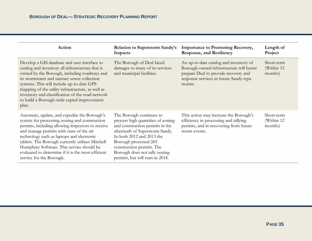
Action Relation to Superstorm Sandy’s Impacts
Importance to Promoting Recovery, Response, and Resiliency
Length of Project
Reexamine the Borough’s Master Plan elements and prepare a sustainability element to address post-Sandy strategies and policies related to hazard mitigation, community resiliency, and forecasted sea level rise and its impacts. This should involve amending the goals and objectives, integration of assessment of community vulnerabilities exacerbated by Superstorm Sandy from this SRPR, as well as up-to-date mapping of current land uses, new FEMA mapping, community facilities, and important natural resources areas.
The last time the Master Plan was reexamined was in 1999. However, after Superstorm Sandy, it is important that planning documents address natural resources and recovery, response, and resiliency, especially issues dealt with in the aftermath of Superstorm Sandy.
Planning can mitigate risks and vulnerabilities, and protect property and safety.
Short-term (Within 12 months)
Reevaluate the Borough’s Emergency Operating Plan to incorporate updates and revisions based on key lessons learned from Sandy and related post-storm response efforts.
Superstorm Sandy required an immediate emergency response.
Planning can mitigate risks and vulnerabilities, and protect property and safety. An updated emergency operating plan will help to improve efficiency of future emergency responses.
Short-term (Within 12 months)

BOROUGH OF DEAL— STRATEGIC RECOVERY PLANNING REPORT
PAGE 34
Action Relation to Superstorm Sandy’s Impacts
Importance to Promoting Recovery, Response, and Resiliency
Length of Project
Prepare a Borough Debris Management Plan and provide the Department of Public Works with an emergency staging facility and a designated debris management area.
Superstorm Sandy required a significant response by the Department of Public Works. Debris was deposited at a temporary management site at the Deal Casino. Had the storm occurred in the summer months, the Borough would have had limited options for debris management sites.
An efficient response of the Department of Public Works, including a proper staging facility, is critical during times of emergency and will help to increase response and protect lives and property. The DPW has to be property staffed and equipped to remove any debris from the roadways and to reduce hazardous conditions.
Short-term (Within 12 months)
Update the Borough’s Capital Improvement Plan identifying needed capital improvements to improve local resiliency.
The Borough of Deal sustained damages to many of its services and municipal facilities.
An up-to-date catalog and inventory of Borough-owned infrastructure will better prepare the Borough of Deal to provide recovery and response services in future Sandy-type storms
Short-term (Within 12 months)
BOROUGH OF DEAL— STRATEGIC RECOVERY PLANNING REPORT
PAGE 35
Action Relation to Superstorm Sandy’s Impacts
Importance to Promoting Recovery, Response, and Resiliency
Length of Project
Develop a GIS database and user interface to catalog and inventory all infrastructure that is owned by the Borough, including roadways and its stormwater and sanitary sewer collection systems. This will include up-to-date GPS mapping of the utility infrastructure, as well as inventory and classification of the road network to build a Borough-wide capital improvement plan.
The Borough of Deal faced damages to many of its services and municipal facilities.
An up-to-date catalog and inventory of Borough-owned infrastructure will better prepare Deal to provide recovery and response services in future Sandy-type storms
Short-term (Within 12 months)
Automate, update, and expedite the Borough’s system for processing zoning and construction permits, including allowing inspectors to receive and manage permits with state of the art technology such as laptops and electronic tablets. The Borough currently utilizes Mitchell Humphrey Software. This service should be evaluated to determine if it is the most efficient service for the Borough.
The Borough continues to process high quantities of zoning and construction permits in the aftermath of Superstorm Sandy. In both 2012 and 2013 the Borough processed 269 construction permits. The Borough does not tally zoning permits, but will start in 2014.
This action may increase the Borough’s efficiency in processing and tallying permits, and in recovering from future storm events.
Short-term (Within 12 months)

BOROUGH OF DEAL— STRATEGIC RECOVERY PLANNING REPORT
PAGE 36
Action Relation to Superstorm Sandy’s Impacts
Importance to Promoting Recovery, Response, and Resiliency
Length of Project
Update the Borough’s current development ordinances and tax maps, and codify all Borough ordinances to reflect recommendations and changes to the Master Plan. The Borough started the codification process and has completed this for Development Regulations Chapter XXX, but no other ordinances have been codified.
Post-Sandy planning work has brought necessary changes to the tax map and Borough ordinances.
These are necessary for the Borough to be able to provide planning services and improve community resiliency after future storms.
Short-term (Within 12 months)
Install a Borough-wide Supervisory Control and Data Acquisition (SCADA) system in conjunction with the Borough’s owned and operated facilities (including Borough Hall and Police Department, fire houses, etc.) to communicate critical alarms to a centralized location or operational personnel.
The Borough of Deal sustained damages to various services and municipal facilities.
This can: provide the Borough accurate information on water and wastewater collection, pump control and station performance; provide alarm notifications of system failure and emergency levels; protect quality of environment by preventing sewer spills into local waterways; and monitor fire, security, power failures, and generator operations.
Short-term (Within 12 months)
Participate in FEMA’s Community Rating System (CRS).
FEMA’s CRS promotes recovery from Sandy-type storms.
CRS participation results enhanced public safety, reduced property damage, and discounted flood insurance premium rates, among other benefits.
Short-term (but ongoing for longer than 12 months)

BOROUGH OF DEAL— STRATEGIC RECOVERY PLANNING REPORT
PAGE 37
Action Relation to Superstorm Sandy’s Impacts
Importance to Promoting Recovery, Response, and Resiliency
Length of Project
Purchase more SUVs for the Police Department and higher wheeled vehicles for emergency response, including 6x6 military vehicles or similar style trucks for storm and snow emergency response.
Some areas of the Borough faced issues with stormwater drainage, which hindered the capacity of emergency response vehicles.
This will allow Borough personnel involved in emergency response to provide a quicker response through flooded roadways.
Short-term (Within 12 months)
Provide emergency generators at key community facilities, including at the municipal building, the fire house, and at the Borough garage. Back-up systems need to be implemented in case of a generator malfunction.
Power outages after Superstorm Sandy caused delays in providing emergency services to residents.
This could improve reliability in service, response time, and access for emergency services post-storm.
Mid-term (Within 24-months)
Purchase generator-powered portable lighting to be utilized during power outages.
Power outages after Superstorm Sandy caused left residents and businesses vulnerable to unsafe activity.
Having certain areas throughout the Borough properly illuminated during power outages and in the aftermath of Sandy-type storms will enhance the safety of the community and deter crime.
Mid-term (Within 24-months)
Improve the drainage problem throughout the Borough to relieve flooding from flood prone areas (Example: Stratford Avenue and Brighton Avenue), as suggested by the Borough’s participation in the FEMA Flood Mitigation Assistance Funding Opportunity.
These areas of the Borough flooded during Superstorm Sandy. In addition, they are already prone to regular flooding during high tide and full moon events.
This will help alleviate flooding during Sandy-type events, will reduce recovery time, and will allow for easier emergency service access.
Long-term (Within 36 months)

BOROUGH OF DEAL— STRATEGIC RECOVERY PLANNING REPORT
PAGE 38
Summary of Actions and Priorities The recommended actions for the Borough of Deal serve as a comprehensive approach to both recovering from Superstorm Sandy and reducing vulnerabilities to future storms.
Immediate/Short-term needs include:
Reexamining the Borough’s Master Plan Elements;
Reevaluating the Borough’s Emergency Operating Plan;
Preparing a Debris Management Plan and providing the Department of Public Works with an emergency staging facility and a designated debris management area;
Updating the Borough’s Capital Improvement Plan;
Developing a GIS database and user interface to catalog all Borough-owned infrastructure;
Automating and updating the zoning and construction permit process;
Updating the Borough’s current development ordinances and tax map, and codify all Borough ordinances to reflect recommendations and changes to the Master Plan;
Installing a Borough-wide Supervisory Control and Data Acquisition (SCADA) system;
Participating in FEMA’s Community Rating System (CRS); and
Purchasing more SUVs for the Police Department and higher wheeled vehicles for emergency response.
Mid-term needs include:
Providing backup power at key community facilities; and
Purchasing generator-powered portable lighting to be utilized during power outages.
Long-term needs include:
Improving the drainage problem throughout the Borough to relieve flooding from flood prone areas.
In addition to the above recommended actions, this SRPR also recommends that any new development within the Borough of Deal employ storm-resistant infrastructure and building strategies. Potential examples include: landscaped streetscape improvements; rain gardens; the use of berms or levees to protect capital facilities; and raising electrical equipment, HVAC units, meters, and other appliances and utilities at key community facilities. Green infrastructure and resilient design are encouraged for future developments. Deal should prioritize and assess the use of sustainable building design and techniques as they relate to housing and infrastructure in the Borough.

BOROUGH OF DEAL— STRATEGIC RECOVERY PLANNING REPORT
PAGE 39
Deal will be seeking additional funding from the NJ Department of Community Affairs as part of the Post Sandy Planning Assistance Grant Program (PSPAGP) for the following activities eligible for funding under the program:
Reexamining the Borough’s Master Plan Elements;
Reevaluating the Borough’s Emergency Operating Plan;
Automating and updating the zoning and construction permit process;
Updating the Borough’s current development ordinances and tax map, and codify all Borough ordinances to reflect recommendations and changes to the Master Plan;
Preparing a Capital Improvement Plan identifying needed capital improvements to improve local resiliency as described above;
Preparing a Debris Management Plan; and
Developing a GIS database to support future planning efforts
All of the foregoing will help the Borough improve resiliency by improving the Borough’s knowledge base, establishing clear procedures and protocols for addressing future emergencies and facilitating restoration, and creating a comprehensive planning framework that will enhance the resiliency and sustainability of the Borough and minimize the impacts of future storm events.

BOROUGH OF DEAL— STRATEGIC RECOVERY PLANNING REPORT