Borehole BH-46 – Runway (Pavement Thickness: 0.9 m...
23
Section VI. Works Requirements WKR-101 101 Borehole BH-46 – Runway (Pavement Thickness: 0.9 m + Subgrade/Slope: 1.0 m) Existing Grade: 8.0 m Finished Grade: 9.3 m Subgrade Elevation: 7.4 m Cut height: 0.6 m Pictures of disturbed soil samples Moisture contents of disturbed soil samples Location SS1 SS2 SS3 SS4 SS5 Can Number 1 2 3 4 5 Weight of can & wet soil, g. 228.09 159.56 126.42 163.79 118.55 Weight of can & dry soil, g. 203.40 141.23 115.21 153.17 109.21 Weight of water, g. 34.69 18.33 11.21 10.62 9.34 Weight of can, g. 21.79 21.06 24.90 23.06 22.13 Weight of dry soil, g. 181.61 120.17 90.31 130.11 87.08 Moisture Content, % 19.10 15.25 12.41 8.16 10.72 Subgrade Cut 0.6m
Transcript of Borehole BH-46 – Runway (Pavement Thickness: 0.9 m...
Section VI. Works Requirements WKR-101
101
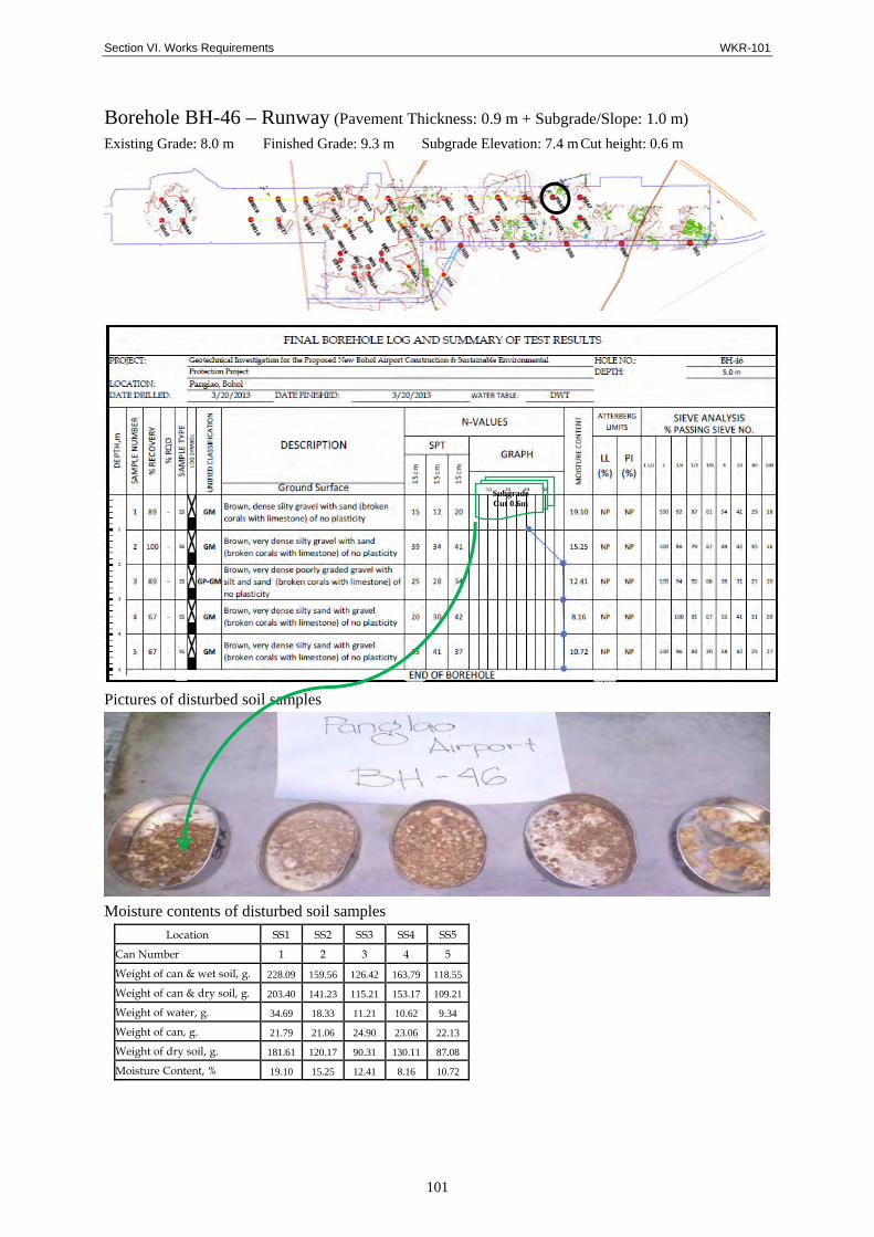
Borehole BH-46 – Runway (Pavement Thickness: 0.9 m + Subgrade/Slope: 1.0 m)
Existing Grade: 8.0 m Finished Grade: 9.3 m Subgrade Elevation: 7.4 m Cut height: 0.6 m
Pictures of disturbed soil samples
Moisture contents of disturbed soil samples
Location SS1 SS2 SS3 SS4 SS5
Can Number 1 2 3 4 5
Weight of can & wet soil, g. 228.09 159.56 126.42 163.79 118.55
Weight of can & dry soil, g. 203.40 141.23 115.21 153.17 109.21
Weight of water, g. 34.69 18.33 11.21 10.62 9.34
Weight of can, g. 21.79 21.06 24.90 23.06 22.13
Weight of dry soil, g. 181.61 120.17 90.31 130.11 87.08
Moisture Content, % 19.10 15.25 12.41 8.16 10.72
Subgrade Cut 0.6m
Section VI. Works Requirements WKR-102
102
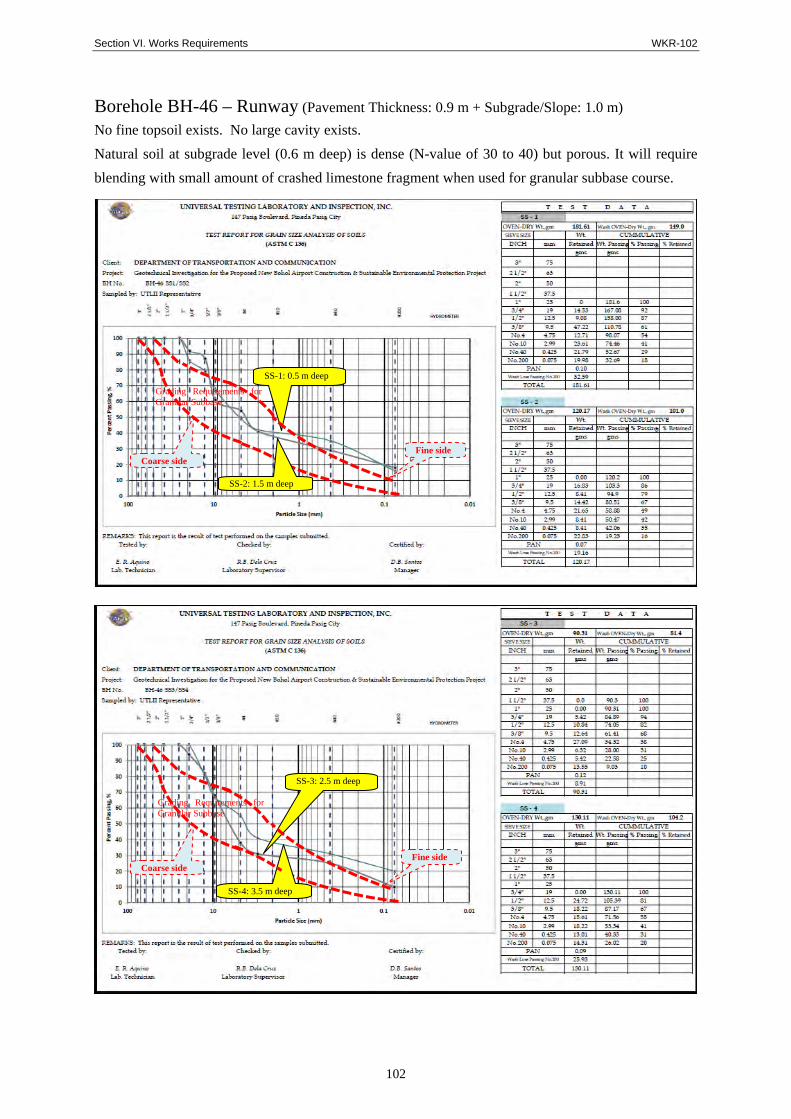
Borehole BH-46 – Runway (Pavement Thickness: 0.9 m + Subgrade/Slope: 1.0 m) No fine topsoil exists. No large cavity exists.
Natural soil at subgrade level (0.6 m deep) is dense (N-value of 30 to 40) but porous. It will require
blending with small amount of crashed limestone fragment when used for granular subbase course.
Coarse side Fine side
SS-1: 0.5 m deep
Grading Requirements for Granular Subbase
SS-2: 1.5 m deep
SS-3: 2.5 m deep
Grading Requirements for Granular Subbase
SS-4: 3.5 m deep
Fine side Coarse side

Section VI. Works Requirements WKR-103
103
Borehole BH-47 – Runway (Pavement Thickness: 0.9 m + Subgrade/Slope: 1.0 m)
Existing Grade: 8.2 m Finished Grade: 9.5 m Subgrade Elevation: 7.6 m Cut height: 0.6 m
Pictures of disturbed soil samples
Moisture contents of disturbed soil samples
Location SS1 SS2 SS3 SS4 SS5
Can Number 1 2 3 4 5
Weight of can & wet soil, g. 174.63 171.52 197.38 132.74 134.59
Weight of can & dry soil, g. 154.30 148.37 162.21 122.42 122.20
Weight of water, g. 20.33 23.15 35.17 10.32 12.39
Weight of can, g. 20.21 21.17 23.86 20.97 25.06
Weight of dry soil, g. 134.09 127.20 138.35 101.45 97.14
Moisture Content, % 15.16 18.20 25.42 10.17 12.75
Subgrade Cut 0.6m
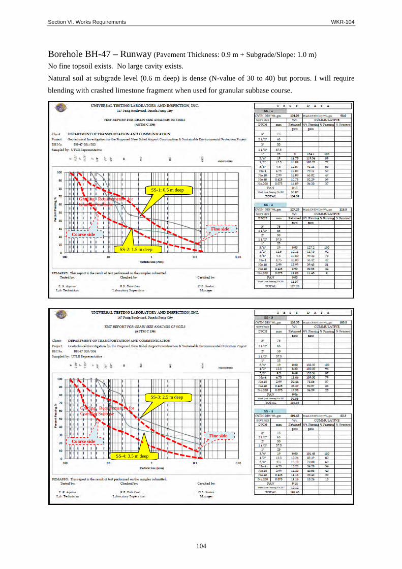
Section VI. Works Requirements WKR-104
104
Borehole BH-47 – Runway (Pavement Thickness: 0.9 m + Subgrade/Slope: 1.0 m) No fine topsoil exists. No large cavity exists.
Natural soil at subgrade level (0.6 m deep) is dense (N-value of 30 to 40) but porous. I will require
blending with crashed limestone fragment when used for granular subbase course.
Coarse side Fine side
SS-1: 0.5 m deep
Grading Requirements for Granular Subbase
SS-2: 1.5 m deep
SS-3: 2.5 m deep
Grading Requirements for Granular Subbase
SS-4: 3.5 m deep
Fine side Coarse side

Section VI. Works Requirements WKR-105
105
Borehole BH-48 – Runway (Pavement Thickness: 0.9 m + Subgrade/Slope: 1.0 m)
Existing Grade: 9.0 m Finished Grade: 9.5 m Subgrade Elevation: 7.6 m Cut height: 1.4 m
Pictures of disturbed soil samples
Moisture contents of disturbed soil samples Location SS1 SS2 SS3 SS4 SS5
Can Number 1 2 3 4 5
Weight of can & wet soil, g. 122.86 144.75 129.83 131.68 122.08
Weight of can & dry soil, g. 113.90 129.87 120.58 115.25 109.10
Weight of water, g. 8.96 14.88 9.25 16.43 12.98
Weight of can, g. 25.40 24.92 25.40 24.75 28.80
Weight of dry soil, g. 88.50 104.95 95.18 90.50 84.30
Moisture Content, % 10.12 14.18 9.72 18.16 15.40
Subgrade Cut 1.4m

Section VI. Works Requirements WKR-106
106
Borehole BH-48 – Runway (Pavement Thickness: 0.9 m + Subgrade/Slope: 1.0 m) No fine topsoil exists. No large cavity exists.
Natural soil at subgrade level (1.4 m deep) is dense (N-value of 60 to 70) but porous. It will require
blending with large amount of crashed limestone fragment when used for granular subbase course.
Coarse side Fine side
SS-1: 0.5 m deep
Grading Requirements for Granular Subbase
SS-2: 1.5 m deep
SS-3: 2.5 m deep
Grading Requirements for Granular Subbase
SS-4: 3.5 m deep
Fine side Coarse side

Section VI. Works Requirements WKR-107
107
Borehole BH-49 – Runway (Pavement Thickness: 0.9 m + Subgrade/Slope: 1.0 m)
Existing Grade: 8.0 m Finished Grade: 9.3 m Subgrade Elevation: 7.4 m Cut height: 0.6 m
Pictures of disturbed soil samples
Moisture contents of disturbed soil samples
Location SS1 SS2 SS3 SS4 SS5
Can Number 1 2 3 4 5
Weight of can & wet soil, g. 170.11 170.80 145.65 167.22 188.26
Weight of can & dry soil, g. 154.06 146.33 133.57 115.25 158.28
Weight of water, g. 16.05 24.47 12.08 141.29 29.98
Weight of can, g. 22.31 20.18 21.17 20.13 23.12
Weight of dry soil, g. 131.75 126.15 112.40 95.12 135.16
Moisture Content, % 12.18 19.40 10.75 21.40 22.18
Subgrade Cut 0.6m

Section VI. Works Requirements WKR-108
108
Borehole BH-49 – Runway (Pavement Thickness: 0.9 m + Subgrade/Slope: 1.0 m) No fine topsoil exists. No large cavity exists.
Natural soil at subgrade level (0.6 m deep) is not much dense (N-value of 30). It will require blending
with large amount of crashed limestone fragment when used for granular subbase course.
Coarse side Fine side
SS-1: 0.5 m deep
Grading Requirements for Granular Subbase
SS-2: 1.5 m deep
SS-3: 2.5 m deep
Grading Requirements for Granular Subbase
SS-4: 3.5 m deep
Fine side Coarse side

Section VI. Works Requirements WKR-109
109
4.1.3 Observations and Findings
The Geological Survey Report (in Apr 2013; by Universal Testing Laboratory and
Inspection) recommends that:
Plasticity Index (PI) of soil is 6 to 10
Bearing capacity is 500 kPa (50 ton/ m²)
Slope gradient should not steeper than 1(V) : 1(H)
Subgrade Reaction (K) is 54 MN/m³ (200 pci ) for pavement or slab-on grade
Among 91 boreholes in total, only one (1) cavity happened to be detected, horizontal
distribution of which was unknown, and possibly another cavity may exist.
Therefore, several engineering practice shall be exercised during construction stage,
as follows:
a) Upon commencement, 5-m deep borehole investigation to the location of
footings for PTB, control tower and administration building would be carried out.
When excavation to the pavement subgrade level is completed, 2-m deep
borehole investigation would be carried out. Those are incorporated in the
specifications, BOQ and drawing of General Requirement so as to dictate
possible cavity.
b) When cavity is found during the course of earthwork, the cavity should be
removed to the bottom irrespective of the designed subgrade thickness.
c) Suspected weak soil underneath, if found, should be replaced, or grouted or
covered by concrete slabs when necessary, subject to further Engineers’
solution.

Section VI. Works Requirements WKR-110
110
4.2 Weather Conditions
Monthly rainfall recorded from 1998 to 2008 is summarized as shown in Table 4.2-1.
Table 4.2-1 Number of rainy days in each month of the year
MONTH 1998 1999 2000 2001 2002 2003 2004 2005 2006 2007 2008 AVERAGE
JANUARY 35.50 177.80 64.10 85.30 52.40 78.50 64.40 26.20 95.70 185.50 264.70 102.74FEBRUARY 0.60 182.00 312.91 63.30 85.50 64.60 97.70 1.30 130.70 25.10 202.80 106.05MARCH 5.00 166.10 206.30 83.90 79.00 18.00 79.30 78.80 183.60 31.80 236.50 106.21APRIL TRACE 173.40 110.90 82.70 99.50 24.90 12.40 60.10 41.50 26.20 107.10 73.87MAY 8.40 73.00 71.00 77.90 47.30 207.20 185.50 42.90 66.80 124.10 179.20 98.48JUNE 52.70 173.10 125.50 193.60 197.90 196.00 148.00 137.50 125.00 244.10 294.00 171.58JULY 71.80 183.60 69.00 152.70 131.70 230.90 116.60 133.10 103.60 141.30 155.30 135.42AUGUST 83.40 219.90 96.40 117.90 130.90 179.00 109.40 129.50 111.50 50.50 241.00 133.58SEPTEMBER 36.80 81.10 67.30 62.10 57.60 122.10 109.40 81.30 72.60 154.20 131.10 88.69OCTOBER 177.40 189.10 301.50 187.40 156.50 266.20 102.10 92.50 140.50 214.60 176.20 182.18NOVEMBER 253.20 158.90 279.40 447.50 148.40 107.20 111.50 204.50 170.00 161.30 120.90 196.62DECEMBER 66.20 162.60 284.40 182.90 82.30 372.10 73.20 269.60 157.90 170.40 NA 182.16
YEARLY TOTAL 791.00 1,940.60 1,988.71 1,737.20 1,269.00 1,866.70 1,209.50 1,257.30 1,399.40 1,529.10 2,108.80 1,577.58
YEARLY AVERAGE 71.91 161.7 165.7 144.8 105.8 155.6 100.8 104.8 116.6 127.4 191.7 131.52
C A L E N D A R Y E A R S 1 9 9 8 - 2 0 0 8 (figures are in millimeters)
The Table shows that annual rainfall volumes are largely varying from 791 mm (in
1998) to2108 mm (in 2008).
The latest weather conditions daily recorded at Tagbilaran City from June 2010 to May
2011, i.e. for atmospheric pressure, temperature, humidity, rainfall, wind speed and
direction are shown in the subsequent pages.
During the same period, annual total rainfall was 2,400 mm. The most rainfall recorded
was in the month of January (i.e. 364 mm), and maximum rainfall was 94.6 mm in
October 2010. Judging from the 1-year record that air pressure of lower than 1000
hPa was not in the record, no tropical depression nor typhoon seemed to hit the area
Unlike Manila or other areas in the Philippines, Visaya area has an average rainfall
through the year (i.e., no distinguished rainy or dray seasons), and numbers of the day
on which more than 5-mm rain falls is 183. Those features in each month of the same
year are shown in Table 4.2-1.
Table 4.2-2 Number of rainy days in each month of the year

Section VI. Works Requirements WKR-111
Tab
le 4
.2-3
(1)
Dai
ly W
eath
er D
ata
at T
agb
ilar
an C
ity
in J
un
e 20
10

Section VI. Works Requirements WKR-112
Tab
le 4
.2-3
(2)
Dai
ly W
eath
er D
ata
at T
agb
ilar
an C
ity
in J
uly
201
0
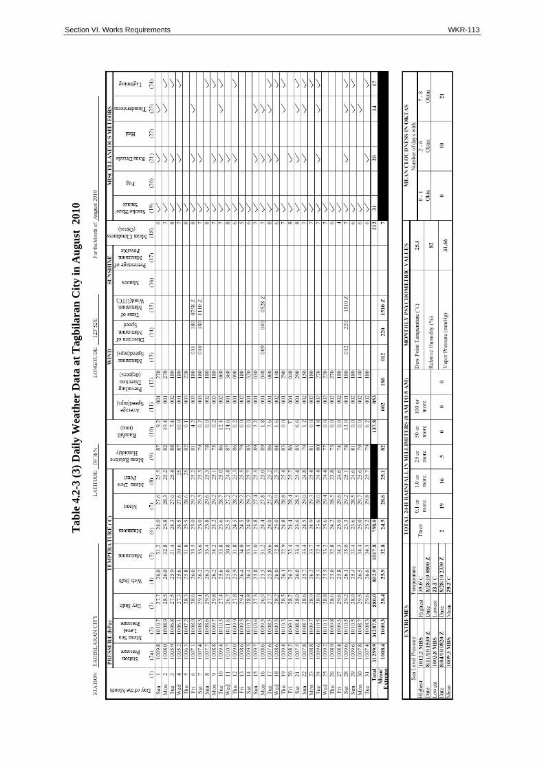
Section VI. Works Requirements WKR-113
Tab
le 4
.2-3
(3)
Dai
ly W
eath
er D
ata
at T
agb
ilar
an C
ity
in A
ugu
st 2
010
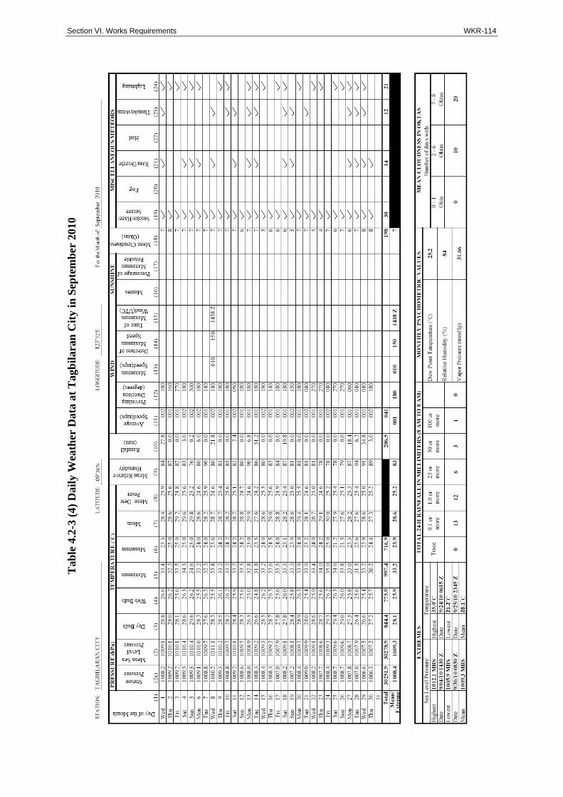
Section VI. Works Requirements WKR-114
Tab
le 4
.2-3
(4)
Dai
ly W
eath
er D
ata
at T
agb
ilar
an C
ity
in S
epte
mb
er 2
010

Section VI. Works Requirements WKR-115
Tab
le 4
.2-3
(5)
Dai
ly W
eath
er D
ata
at T
agb
ilar
an C
ity
in O
ctob
er 2
010

Section VI. Works Requirements WKR-116
Tab
le 4
.2-3
(6)
Dai
ly W
eath
er D
ata
at T
agb
ilar
an C
ity
in N
ovem
ber
201
0
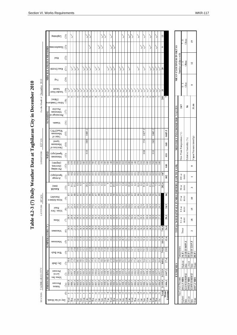
Section VI. Works Requirements WKR-117
Tab
le 4
.2-3
(7)
Dai
ly W
eath
er D
ata
at T
agb
ilar
an C
ity
in D
ecem
ber
201
0

Section VI. Works Requirements WKR-118
Tab
le 4
.2-3
(8)
Dai
ly W
eath
er D
ata
at T
agb
ilar
an C
ity
in J
anu
ary
2011

Section VI. Works Requirements WKR-119
Tab
le 4
.2-3
(9)
Dai
ly W
eath
er D
ata
at T
agb
ilar
an C
ity
in F
ebru
ary
2011

Section VI. Works Requirements WKR-120
Tab
le 4
.2-3
(10
) D
aily
Wea
ther
Dat
a at
Tag
bil
aran
Cit
y in
Mar
ch 2
011

Section VI. Works Requirements WKR-121
Tab
le 4
.2-3
(11
) D
aily
Wea
ther
Dat
a at
Tag
bil
aran
Cit
y in
Ap
ril 2
011

Section VI. Works Requirements WKR-122
Tab
le 4
.2-3
(12
) D
aily
Wea
ther
Dat
a at
Tag
bil
aran
Cit
y in
May
201
1

Section VI. Works Requirements WKR-123
4.3 Land Acquisition and Resettlement
4.3.1 History
Land acquisition of the Right-of-Way (ROW) for the airport project in Panglao Island
already commenced as early as 1990s. Bohol Provincial Government (BPG) had been
entrusted by DOTC, DOT (Department of Tourism) and the Civil Aviation Authority of
the Philippines (CAAP) to conduct the acquisition of the ROW for the project by virtue
of a Memorandum of Agreement (MOA) dated 23rd January 1994. However, the new
project had not been materialized for two decades. During the non-materialization of
the project, another F/S was conducted in 2007, which realigned the project site
bearing North 30 degrees East. As a result, 32.6 ha out of 62.4 ha-land already
acquired became outside of the ROW.
From April to July 2012, under the Preparatory Survey assisted by JICA, a resettlement
action plan (RAP) for the project was prepared in accordance with JICA Guidelines for
Environmental and Social Considerations.
4.3.2 Scale and Status of Land Acquisition and Resettlement
As shown in Table 4.3-1, as of end of June 2013, the total area of the ROW is 223 ha,
which equivalents to 407 lots. Out of the total 407 lots in the ROW, 358 lots, 88.0 %,
are already acquired. Out of the remaining 49 lots, 40 are still for acquisition (under
negotiation), and 9 are for expropriation.
For the 40 plots still for acquisition, ‘Entry Permits’ obtained from the landowners are
necessary to enter the lands, which is under process by the BPG. For the 9 lots for
expropriation, the cases are under study by the Office of Solicitor General before filing
with the Court. Only after the permission by the Court (issuance of ‘Writ of Possession’),
the government agencies can enter the land and demolish houses if necessary. Out of
the 9 lots for expropriation, 4 lots are owned by one landowner, and two houses remain
in these 4 lots. According to DOTC officials, expropriation of the 9 lots including two
houses is most likely to complete within 2013.
Table 4.3-1 Status of Land Acquisitions as of June 2013
Lots Area (sq.m) Lot-wise ratio (%) Area-wise ratio (%)
Acquired through Purchase after Realignment 222 1,436,365 54.5% 64.4% Acquired through Purchase Before Realignment 32 298,639 7.9% 13.4% For Barter 99 321,978 24.3% 14.4% Government Owned ( Road) 5 18,635 1.2% 0.8%Sub-total: Acquired 358 2,075,617 88.0% 93.1% Still for Acquisition (Negotiation) 40 111,383 9.8% 5.0% For Expropriation 9 42,849 2.2% 1.9%Sub-total: Not Yet Acquired 49 154,232 12.0% 6.9%Total 407 2,229,849 100.0% 100.0%
Source: BPG