
BMP Guidebook, Intro - michigan.gov · Michigan NPS BMP Manual Page 3 of 31 Rev 2017.6.27 Foreword...
31
Rev 2017.6.27 Michigan Nonpoint Source Best Management Practices Manual Michigan Department of Environmental Quality Environmental Assistance Center 800-622-9278 www.michigan.gov/deq
Transcript of BMP Guidebook, Intro - michigan.gov · Michigan NPS BMP Manual Page 3 of 31 Rev 2017.6.27 Foreword...

Rev 2017.6.27
Michigan Nonpoint Source Best Management
Practices Manual
Michigan Department of Environmental Quality Environmental Assistance Center 800-622-9278 www.michigan.gov/deq

www.michigan.gov/deq Michigan NPS BMP Manual Page 2 of 31 Rev 2017.6.27
Michigan Nonpoint Source Best Management Practices Manual
Table of Contents
Foreword ................................................................................................................................... 3 Introduction ............................................................................................................................... 3 Storm Water Management Approach....................................................................................... 9 Treatment Train Approach ....................................................................................................... 9 Storm Water BMPs .................................................................................................................. 10 Watershed Planning ................................................................................................................ 11 Hydrology ................................................................................................................................ 12 Fluvial Geomorphology .......................................................................................................... 19 BMPs in the Site Development Process ................................................................................ 23 Local Storm Water Ordinances .............................................................................................. 27 Individual BMPs ...................................................................................................................... 28 References .............................................................................................................................. 30 List of Figures 1. Michigan Laws Administered by the MDEQ Water Resources Division ....................... 7 2. 100% Annual Exceedance Probability, 24 Hour Precipitation .................................... 14 3. 50% Annual Exceedance Probability, 24 Hour Precipitation ...................................... 14 4. 20% Annual Exceedance Probability, 24 Hour Precipitation ...................................... 14 5. 10% Annual Exceedance Probability, 24 Hour Precipitation ...................................... 14 6. 4% Annual Exceedance Probability, 24 Hour Precipitation ........................................ 15 7. 2% Annual Exceedance Probability, 24 Hour Precipitation ........................................ 15 8. 1% Annual Exceedance Probability, 24 Hour Precipitation ........................................ 15 9. Representative 10% Exceedance Precipitation Events for Individual Gages ............. 18 10. Stream Pattern, Dimension, and Profile ................................................................... 20 11. Meander Migration in a Floodplain ........................................................................... 21 List of Tables 1. Standard BMP Elements ........................................................................................... 29

www.michigan.gov/deq Michigan NPS BMP Manual Page 3 of 31 Rev 2017.6.27
Foreword This document supersedes the 1998 Guidebook of Best Management Practices for Michigan Watersheds ('Guidebook'). From its inception, the Guidebook was almost universally referred to as the 'BMP Manual'. Therefore, the name of the document has been changed to be consistent with that usage, to the Michigan Nonpoint Source Best Management Practices Manual ('BMP Manual'). This revised document provides guidance on dealing with nonpoint source (NPS) pollution to restore impaired waters and protect high-quality waters in Michigan. While much of the information from the 1998 Guidebook on the planning, design, construction, and maintenance, of storm water BMPs has been retained, and updated as necessary, this revised manual attempts an increased emphasis on pollution prevention, to minimize the amount of subsequent storm water management or treatment required, as well as storm water infiltration practices and natural channel design. The BMP Manual consists of two parts: 1. This document, containing introductory, background material. 2. Individual BMPs, arranged alphabetically, available on the BMP web page, the
address of which is given below. In the past, the Guidebook was published and distributed exclusively in hard copy. With the advent of electronic content and internet-based distribution, hard copies are no longer published. The BMP Manual is located at the top of a dedicated web page titled BMP Design, Pollutants Controlled Calculation Assistance, and other Technical Manuals. Distributing the manual electronically also allows increased flexibility and quicker turnaround times on corrections or updates. This document and all individual BMPs are given an appropriate version number, based on the last revision date, placed in the lower right corner of each page.
Introduction Origins of NPS Program and Guidebook The 1987 amendment to the Clean Water Act recognized that most point sources were being controlled, and that NPS pollution was causing most of the remaining water quality problems. The amendment required all states to conduct NPS assessments, and develop strategies to address all problems identified. Michigan conducted its assessment in 1987 by distributing surveys statewide to the personnel of various agencies to obtain any information on local NPS problems. The results of this assessment were published in Michigan’s 1988 Nonpoint Pollution Assessment Report. Michigan’s Nonpoint Pollution Control Management Plan, which was also developed in 1988, described program elements necessary to prevent and reduce NPS pollution, many of which were implemented. One aspect of the NPS program, the NPS Watershed Initiative, further promoted the identification of NPS problems at the watershed level and the implementation of BMPs to address them.

www.michigan.gov/deq Michigan NPS BMP Manual Page 4 of 31 Rev 2017.6.27
Out of these initial assessment and planning efforts, the first Guidebook—containing 51 individual BMPs—was published in 1992. In September 1997, three of the BMPs were updated, and two new BMPs were added, bringing the total number of BMPs to 53. An October 1998 reprint of the Guidebook included minor corrections to reflect program and personnel changes. Updating the Guidebook Because of the increased effort at NPS pollution control since the original Guidebook was published, there is perhaps a higher expectation of background knowledge of the average reader of this manual, than with earlier versions, especially among storm water practitioners, who comprise the primary target audience of this manual. Also, in the time since the first Guidebook was published, the amount of NPS pollution control literature has increased greatly. Therefore, as compared to earlier versions, this manual sometimes only very briefly describes subjects regarding NPS pollution sources and causes, perceived threats, and priorities. It will generally refer the reader to other, more detailed external references, such as Section 319 of the Clean Water Act, Michigan's NPS Program Plan, the Integrated Report, and other Michigan Department of Environmental Quality (MDEQ) and U.S. Environmental Protection Agency (USEPA) watershed planning material. Target Audience The manual's target audience includes:
- The storm water practitioner, at any of various levels of involvement and knowledge, including, architect, consultant, contractor, developer, engineer, landowner, planner, or regulator, who is searching for technical information regarding the deployment or installation of specific practices.
- NPS stakeholders seeking more general information on the types of practices available,
to make them aware of potential ways to control NPS pollution.
- The general public, for certain informational and educational (I&E) practices, usually managerial (versus physical) in nature.
Programs, Activities, and Industries that Rely on BMPs Listed below are some programs, activities, and industries that rely on BMPs, including those in this manual, plus from some other sources mentioned in the brief descriptions provided. Agriculture As part of its responsibilities of overseeing the environmental aspects of the agriculture industry, the Michigan Department of Agriculture and Rural Development develops and publishes “generally accepted agricultural management practices.” The current list of practices, which are reviewed and updated annually, includes: Animal Care, Cranberry Production, Farm Markets, Irrigation, Manure, Nutrients, Pesticide Utilization and Pest Control, and Site Selection.

www.michigan.gov/deq Michigan NPS BMP Manual Page 5 of 31 Rev 2017.6.27
The U.S. Department of Agriculture Natural Resource Conservation Service (NRCS) provides technical information on agricultural BMPs for the conservation of soil, water, air, plant, and animal resources, through its electronic Field Office Technical Guide (FOTG). BMPs are customized to the local level so that they apply specifically to the geographic area for which they are prepared. Finding and fixing agricultural-related problems has been a priority of the MDEQ NPS Program since its inception. Construction Storm Water Program The MDEQ is responsible for administering the state and federal construction storm water statutes. Any earth change activities (clearing, grading, excavating, stockpiling, etc.) that disturb one (1) or more acres of land or are within 500 feet of a lake or stream are regulated under the Part 91 Soil Erosion and Sedimentation Control (SESC), of the Natural Resources and Environmental Protection Act, 1994 PA 451, as amended (NREPA), and Construction Storm Water programs. Owners of properties on which regulated earth changes will occur must obtain an SESC permit from the appropriate Municipal or County Enforcing Agency (MEA or CEA). Earth change activities on regulated sites can also be conducted by Authorized Public Agencies (APAs), which are given the authority to self-regulate. As part of their certification, APAs are required to submit to the MDEQ SESC Procedures, which include BMPs that cover their agency’s activities. The MDEQ, Water Resources Division (WRD), has adopted a process called "Permit-by-Rule" (Rule 2190 (R 323.2190), promulgated under Part 31, Water Resources Protection, of the NREPA) for issuing the necessary storm water coverage. Permit-by-Rule streamlines the permitting process and is dependent upon the applicant first obtaining Part 91 coverage (i.e., obtaining an SESC permit from the appropriate Part 91 permitting agency, or being designated an APA). For the disturbance of sites from one to five acres in size, the permit applicant receives automatic storm water coverage upon the applicant obtaining a Part 91 permit (or undertaking the project as an APA). Although the coverage is automatic, the permittee must comply with the requirements of Permit-by-Rule. For the disturbance of sites five or more acres in size, the permit applicant must obtain a Part 91 permit (or undertake the project as an APA), and submit an application for Notice of Coverage (NOC) to the MDEQ, WRD. Along with the NOC application, the permit applicant must submit a copy of the SESC permit, approved SESC plan, site location map, and the appropriate permit fee. When MDEQ NOCs are issued, or when earth change activities carried out on sites between one and five acres in size receive automatic coverage under Michigan's Permit-by-Rule, landowners must, in implementing SESC plans, ensure that sites are inspected by the specified certified construction storm water operator at least weekly, and within 24 hours of any precipitation events that result in site discharges, and that any necessary corrective actions are carried out.

www.michigan.gov/deq Michigan NPS BMP Manual Page 6 of 31 Rev 2017.6.27
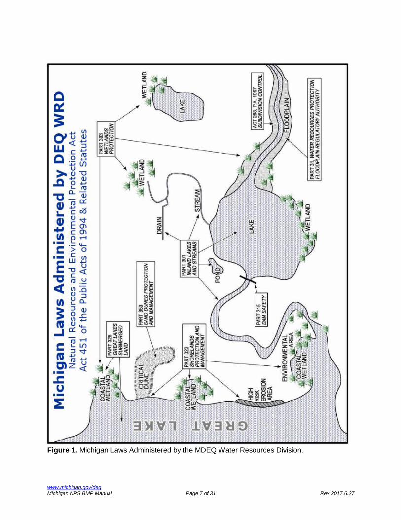
Forestry The Michigan Department of Natural Resource (MDNR) oversees and regulates both public and private forestry operations in the state. The MDNR/MDEQ manual Sustainable Soil and Water Quality Practices on Forest Land (2009) describes a set of voluntary forestry BMPs for protecting soil and water, while allowing appropriate use of forest resources. The manual is targeted at everyone involved with growing, managing, and harvesting trees, including foresters, loggers, and forest landowners. Great Lakes Shorelands Management Program The MDEQ Great Lakes Shorelands Management Program administers statutes dealing with shorelands protection and management, Great Lakes submerged lands, and sand dune protection and management. This program provides protection from the natural hazards of coastal erosion and flooding, and environmental protection of fragile coastal areas. The program also provides grants to state and local units of government. Figure 1 graphically depicts the locations where the statutes administered by this program apply. Industrial Storm Water Program The MDEQ began issuing industrial storm water permits in 1994, as a result of the federal National Pollutant Discharge Elimination System (NPDES) regulations governing such discharges. The three types of permits are: the generic baseline general permit, the generic general permit with monitoring requirements, and the site-specific individual permit. There are currently approximately 4,000 facilities statewide with industrial storm water discharge permits. Industrial storm water permit authorization requires applicant facilities to have a certified operator who supervises and controls storm water operations, and who develops and implements a storm water pollution prevention plan, which must include appropriate structural and non-structural BMPs. Inland Lakes and Streams Program The MDEQ Inland Lakes and Streams Program is responsible for the protection of the natural resources and the public trust waters of the inland lakes and streams of the state. The program oversees activities including dredging, filling, constructing or placing structures on bottomlands, constructing or operating marinas, interfering with the natural flow of water, or connecting ditches or canals to inland lakes or streams. Figure 1 graphically depicts the locations where the statutes administered by this program apply. Municipal Separate Storm Water (MS4) Program The goal of the Municipal Separate Storm Sewer System (MS4) program is to reduce the discharge of pollutants from storm water collection and drainage systems to surface waters of the State. An MS4 is a drainage system (including roads, storm drains, pipes, ditches, etc.) that is neither a combined sewer, nor part of a sewage treatment plant. During wet weather, pollutants can be transported through MS4s to local water bodies.
www.michigan.gov/deq Michigan NPS BMP Manual Page 7 of 31 Rev 2017.6.27
Figure 1. Michigan Laws Administered by the MDEQ Water Resources Division.

www.michigan.gov/deq Michigan NPS BMP Manual Page 8 of 31 Rev 2017.6.27
The municipal storm water program requires owners of MS4s serving communities over a certain population to obtain permits to be able to discharge municipal storm water. MS4 permittees include cities, townships, villages, county agencies, universities, and school districts. Most permittees are covered under a general permit, based on their storm water management approach. In October 2000, the USEPA published the National Menu of Best Management Practices for Stormwater Phase II, in which has been continually updated since then (USEPA, 2012). The Menu of BMPs is based on the Stormwater Phase II Rule's six minimum control measures, which are:
1. Public Education: For MS4 owners to inform individuals and households about ways to reduce storm water pollution.
2. Public Involvement: For MS4 owners to involve the public in the development,
implementation, and review of an MS4's storm water management program.
3. Illicit Discharge Detection and Elimination: For identifying and eliminating illicit discharges and spills to storm drain systems.
4. Construction: For MS4 owners and construction site operators to address storm water
runoff from active construction sites.
5. Post-Construction: For MS4 owners, developers, and property owners to address storm water runoff after construction activities have completed.
6. Pollution Prevention/Good Housekeeping: For MS4 owners to address storm water
runoff from their own facilities and activities. NPS Program The MDEQ NPS Program assists local governments, nonprofits, and other state, federal, and local partners in reducing NPS pollution. The program operates on a watershed basis, as it works with stakeholders in developing and implementing plans to protect waters of the state. The program consists of the following major activities:
1. Technical Assistance: Helping develop and implement watershed management plans, selecting BMPs, and reviewing site plans.
2. Information and Education (I&E): Educating the public about NPS pollution, including
actions to reduce or eliminate it.
3. Grants: Funded by the Clean Water Act, the Clean Michigan Initiative, and other sources, for watershed plan development, BMP implementation, and I&E. BMPs funded by the NPS Program are to be included in the BMP Manual.
4. Compliance and Enforcement: Responding to and investigating complaints, corrective
actions follow up, and sometimes assisting with escalated enforcement actions.
www.michigan.gov/deq Michigan NPS BMP Manual Page 9 of 31 Rev 2017.6.27
5. Monitoring and Field Investigations: Determining BMP effectiveness, whether watershed planning efforts are protecting or improving water quality, and overall NPS program effectiveness; Total Maximum Daily Load (TMDL) related monitoring.
Sand Dune Protection Program The MDEQ is responsible for protecting Michigan's most unique and fragile sand dunes, by minimizing the impacts of development within designated critical dune areas along the Great Lakes shoreline. Earthmoving, vegetation removal, and construction activities within a critical dune area are regulated through a permit program. Wetlands Program The MDEQ Wetlands Program is responsible for protecting Michigan's wetlands, which are defined as lands characterized by the presence of water at a frequency and duration sufficient to support wetland vegetation or aquatic life, and are commonly referred to as bogs, swamps, or marshes.
Storm Water Management Approach The preferred steps in storm water management, in descending order, are: 1. Prevention/Minimization/Infiltration 2. Treatment 3. Mitigation The priority to infiltrate, or prevent or minimize the generation of, storm water makes sense for various reasons. If no storm water is generated, no further steps are needed—no treatment of contaminated storm water prior to discharge, nor the mitigation of any downstream impacts, such as erosion or sedimentation. This is beneficial not only to receiving water quality; it is also economical, in that it can save capital and operation and maintenance costs, of any management practices that would otherwise be required. Additional steps in the storm water management approach, which are sometimes required—alone or in combination—are:
4. Conveyance 5. Storage
Prevention/minimization can also reduce the need for these steps at or downstream of a given site. The increasingly popular concept of "low-impact design" (referred to as LID) is based on a similar approach to storm water management, with the emphasis on minimization or prevention.

www.michigan.gov/deq Michigan NPS BMP Manual Page 10 of 31 Rev 2017.6.27
Treatment Train Approach When the generation of storm water is inevitable, it should be managed with the "treatment train" approach, which is treating runoff using storm water management practices placed in series, where each practice targets specific pollutants, and/or regulates a specific aspect of the runoff hydrology. The treatment train approach should, to the extent possible, follow the "storm water management approach" described in the previous section, which emphasizes minimization or prevention, over any subsequent steps that may need to be taken (treatment, etc.). An example treatment train for a paved surface parking lot could include any of the following:
1. Minimizing impervious area through "low-impact design" (mentioned in the previous section), including such practices as:
- Instead of a surface parking lot, using either a stand-alone or integrated parking
structure.
- Minimizing parking lot bay size and number (which can require a zoning variance), through (a) smaller bays identified for compact cars, (b) parking space "sharing" with adjacent, complementary land uses, etc.
- Optimizing site traffic flow (by using one-way driving lanes, minimizing driving lane
widths, etc.).
2. Infiltrating runoff volume by using modular, porous asphalt, or porous concrete pavement, instead of standard (impervious) asphalt or concrete pavement.
3. Minimizing potential pollutants with regular pavement cleaning (either through sweeping,
or vacuuming of porous pavement), and careful use of de-icing chemicals.
4. Minimizing runoff volume and pollutants by treating storm water runoff within on-site parking lot island bio-retention cells or rain gardens.
5. Minimizing erosion, filtering runoff, and slowing runoff velocity by conveying site storm
water runoff through vegetated or rip rapped channels, to any subsequent off-site treatment, or ultimate discharge.
6. Minimizing runoff volume and pollutants by infiltrating runoff with off-site infiltration
practices, such as infiltration trench, infiltration basin, bio-retention, or rain garden.
7. Minimizing runoff volume and/or pollutants by treating runoff off-site with any of various retention or detention practices, such as basins, or constructed wetlands.

www.michigan.gov/deq Michigan NPS BMP Manual Page 11 of 31 Rev 2017.6.27
Storm Water BMPs The individual BMPs that comprise the second part of this manual are used to deal with storm water, snowmelt, other sources of NPS runoff, and associated pollutants. There are many ways in which practices can be grouped or categorized, including:
- General type: physical, vegetative, or managerial. - Time scale: temporary (i.e., construction- or ’earth change’-related) versus permanent. - Function: prevention/minimization, storage, treatment, conveyance, or mitigation.
Although the BMPs in this manual provide general, relevant design and implementation information, (1) no single practice is necessarily applicable to every site; and (2) no single practice standard can include sufficient specification to cover all possible uses, conditions, or variations. Each site should be evaluated individually, and specific practices should be selected accordingly. The BMPs in this manual, which are arranged alphabetically, were developed specifically for use in Michigan. BMPs developed for other states may not necessarily work in Michigan. For example, vegetation listed in standards for other states may not apply in Michigan, and in extreme cases may be considered invasive species. The list of practices in this manual is not all-inclusive. There is constant innovation in the storm water field, and new practices for which there are not yet standard or accepted specifications are constantly being developed. Consider these and other lesser-known practices only on a practice- or site-specific basis. It is important to follow all relevant specifications when designing and installing practices. It is also critical that all practices be maintained; lack of maintenance is frequently the shortcoming of storm water management practice performance. Although the listed practices are expected to work when correctly designed, installed, and maintained, creativity and innovation are encouraged. Refer to the external sources cited throughout the manual, and those listed on the manual web page.
Watershed Planning Watershed management plans in Michigan are developed primarily by local groups or agencies. An organization seeking MDEQ implementation grant funds must submit their watershed plan to the MDEQ for review. To be approved, the plan must meet criteria established by Section 319 Federal Register guidance or Clean Michigan Initiative (CMI) rules. More recent watershed planning efforts have included TMDLs developed by the MDEQ, and storm water pollution prevention initiatives developed by some NPDES municipal storm water permitees. All of these planning efforts entail BMP selection to some extent.

www.michigan.gov/deq Michigan NPS BMP Manual Page 12 of 31 Rev 2017.6.27
For in-depth information on the watershed plan development process, please refer to the following references, the summaries of which indicate what sections refer specifically to BMP selection and other related topics: MDEQ. 2000. Developing a Watershed Management Plan for Water Quality: An Introductory
Guide. Chapter 7 of the guide, titled “Identifying Systems of Best Management Practices (BMPs) Needed”, discusses the relationship of BMP selection and cost estimation with respect to the watershed planning process. The guide describes various ways in which potential individual or systems of BMPs can be identified, and suggests ways of compiling, tabulating, and presenting the relevant information in the watershed plan.
USEPA. 2008. Handbook for Developing Watershed Plans to Restore and Protect Our Waters. Office of Water, Nonpoint Source Control Branch. EPA 841-B-08-002.
This approximately 300-page handbook provides an in-depth explanation of the watershed planning process, including further details on the nine minimum required elements first introduced by the USEPA in 2003, and described in the paragraph above. While there is material throughout the handbook relating to the various aspects of BMPs, the handbook presents a specific, two-step process for BMP selection in the watershed planning context—first, the identification of possible BMPs (described in chapter 10), then an evaluation of those possibilities, and selection of final BMPs (described in chapter 11).
USEPA. 2013. Nonpoint Source Program and Grants Guidelines for States and Territories.
These Guidelines include the required nine minimum elements of a watershed management plan. In general, the USEPA requires that nine-element watershed management plans be developed prior to implementing projects funded with Section 319 or matching funding.
The MDEQ NPS program web site is a good source of information on watershed planning. It lists NPS program staff (including the current watershed planning coordinator), graphically depicts (through an interactive statewide watershed map) and lists all previously approved watershed plans, provides links to electronic versions of most of those plans, and provides links to various reference material. Before undertaking the development of a watershed management plan (including BMP selection), it is recommended that the MDEQ watershed planning coordinator be contacted, to obtain all current requirements and relevant guidance.
Hydrology Hydrology is defined as the occurrence, distribution, and movement of water both on and under the earth's surface. This movement of water is known as the hydrologic cycle, where water falls on the ground as rain, a portion soaks into the ground, more is taken up by plants, and another portion runs off the surface into drainage ways. Throughout this process water evaporates into the atmosphere, where it becomes rain, and the cycle starts over.

www.michigan.gov/deq Michigan NPS BMP Manual Page 13 of 31 Rev 2017.6.27
NPS pollution is often driven by hydrology. Pollutants sitting on the ground are picked up by the runoff generated by rainfall, and can be carried into surface waters or percolate into groundwater. When local hydrology is modified through landscape changes, degradation may occur due to landforms adapting to changing runoff patterns and groundwater movement. Hydrologic changes can cause loss of habitat, excess erosion, flooding, reduction of stream base flow, and significant modification of river channels. Site hydrology is defined by groundwater recharge, stream channel protection, and flooding. Additionally, site hydrology must be known to properly select, size, and place BMPs to treat storm water runoff. BMP design is based on removing pollutants carried in runoff, or on maintaining or restoring local hydrology, to prevent impairments caused by changing flow patterns. The recommended hydrologic baseline condition used in this manual is the presettlement hydrology of the site. This means BMP design should attempt to restore or maintain the volume and rate of runoff from the site to what it would have been if no human development had ever occurred there. This condition would normally be a meadow or forest. This is often difficult to achieve in areas where heavy urbanization has occurred. In some cases it will not be possible to restore a site to the presettlement hydrologic conditions at a reasonable cost. In these cases, volume and rate should be controlled to the extent possible. In no case should the runoff volume or rate of a site be increased over the existing hydrologic state. 24-Hour Precipitation Amounts of Various Annual Exceedance Probabilities for BMP Design One of the steps in the design of structural BMPs is determining the appropriate precipitation design event(s), from which expected runoff volumes and flow rates can be calculated. Precipitation events are defined by:
(a) Intensity—The rate at which precipitation falls during an event;
(b) Duration—The length of an event; and
(c) Frequency—How likely an event of a given size or larger is expected to occur in any year, referred to as the annual exceedance probability (AEP). Precipitation frequency has also historically been (and continues to be) described by the average recurrence interval, which can be calculated by taking the inverse of the decimal form of the AEP.
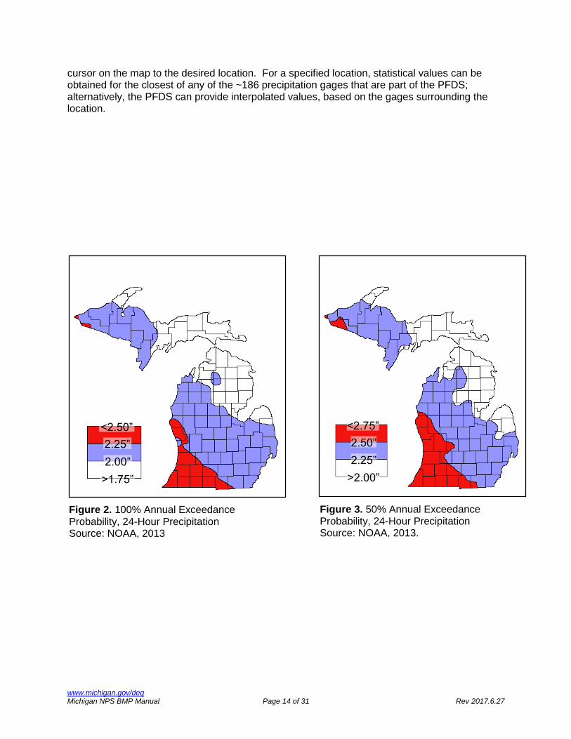
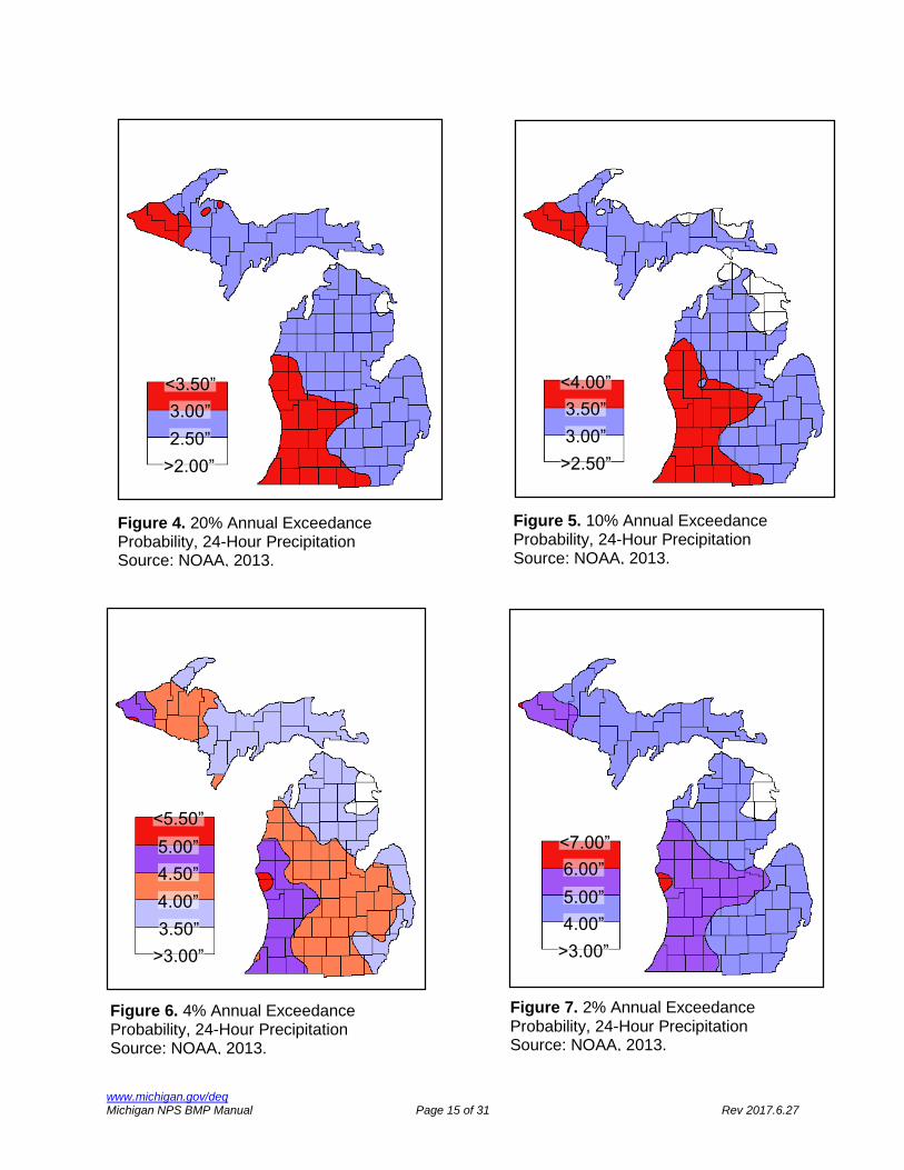
Precipitation amounts can be estimated for selected storm durations and AEPs using statistical analysis of rainfall gage data. The design specifications in this manual utilize storms of 24-hour duration, with AEPs of 99.9%, 50%, 20%, 10%, 4%, 2%, and 1%; the corresponding average recurrence intervals of these AEPs are one (1), two (2), five (5), 10, 25, 50, and 100 years. Figures 2 through 8 depict these expected 24-hour precipitation depths statewide, for each AEP mentioned above. These figures are provided for illustrative purposes only, to give a general idea of the magnitude of these events; the figures should absolutely not be used to determine design precipitation events for specific locations or projects. When design precipitation events are required for a specific project or BMP location, it is recommended that such values be obtained from a published, recognized source, such as the National Oceanic and Atmospheric Administration’s (NOAA) Precipitation Frequency Data Server (PFDS), which provides a very intuitive, user-friendly, map-based interface. Locations can be specified either by directly entering latitude and longitude coordinates, or by moving a
www.michigan.gov/deq Michigan NPS BMP Manual Page 14 of 31 Rev 2017.6.27
cursor on the map to the desired location. For a specified location, statistical values can be obtained for the closest of any of the ~186 precipitation gages that are part of the PFDS; alternatively, the PFDS can provide interpolated values, based on the gages surrounding the location.
Figure 2. 100% Annual Exceedance Probability, 24-Hour Precipitation Source: NOAA, 2013
>1.75”
2.00”
2.25”
<2.50”
Figure 3. 50% Annual Exceedance Probability, 24-Hour Precipitation Source: NOAA, 2013.
>2.00”
2.25”
2.50”
<2.75”
www.michigan.gov/deq Michigan NPS BMP Manual Page 15 of 31 Rev 2017.6.27
Figure 4. 20% Annual Exceedance Probability, 24-Hour Precipitation Source: NOAA, 2013.
>2.00”
2.50”
3.00”
<3.50”
Figure 5. 10% Annual Exceedance Probability, 24-Hour Precipitation Source: NOAA, 2013.
>2.50”
3.00”
3.50”
<4.00”
Figure 6. 4% Annual Exceedance Probability, 24-Hour Precipitation Source: NOAA, 2013.
4.00”
4.50”
5.00”
<5.50”
>3.00”
3.50”
Figure 7. 2% Annual Exceedance Probability, 24-Hour Precipitation Source: NOAA, 2013.
4.00”
5.00”
6.00”
<7.00”
>3.00”

www.michigan.gov/deq Michigan NPS BMP Manual Page 16 of 31 Rev 2017.6.27
Unified Sizing Criteria The goal of unified sizing criteria is to use a consistent approach to sizing practices that perform effectively and efficiently, are simple to administer, promote better site design, and are flexible enough to respond to special site and receiving water conditions. The unified sizing criteria are intended to be applied to the design of a site so that the criteria may be achieved through a combination of BMPs and not necessarily a single BMP. Development of designs using these criteria is expected to address all aspects of runoff control. The following five unified sizing criteria are presented for use in the design of storm runoff BMPs in this manual:
- Infiltration - Water quality volume - Channel protection - Over bank flooding - Extreme flooding
The unified sizing criteria are defined as: Infiltration – Maximize the infiltration of storm water runoff as appropriate for the site. The minimum infiltration volume goal should be the additional volume of runoff generated over the calculated presettlement volume of runoff up to the 2-year, 24-hour event. Site constraints may limit the ability to fully achieve this goal at all sites. Use of increased interception,
5.00”
6.00”
7.00”
<8.00”
Figure 8. 1% Annual Exceedance Probability, 24-Hour Precipitation Source: NOAA, 2013.
>4.00”
www.michigan.gov/deq Michigan NPS BMP Manual Page 17 of 31 Rev 2017.6.27
evapotranspiration, or reuse to achieve other criteria may reduce the volume of water available for infiltration. Water Quality Volume - Also referred to as the "first flush" volume. Treatment of runoff produced by all storm events up to and including the 10 percent exceedance runoff-generating storm event, as described in the following section, titled “10 Percent Exceedance Precipitation Events”. A conservative alternative is treatment of 1.0 inches of runoff over the entire site. Channel Protection – Maintain the calculated presettlement runoff volume and peak flow rate for all storm events up to the 2-year, 24-hour event. On most sites, meeting the volume requirement of channel protection will also meet the peak flow rate requirement. Additionally, meeting the volume reduction requirement through infiltration, vegetative BMPs, or reuse will also meet the water quality volume requirement. Runoff volume reduction can be achieved through infiltration, interception, evapotranspiration, and reuse. In cases where site constraints prevent control of the full channel protection volume, volume control should still be maximized, and the 1-year, 24-hour storm should be captured and released over a 24-hour period. Controlling the volume of runoff is critical to channel protection. When volume control is not possible, the more restrictive criteria for controlling runoff rate partially compensates for the lack of volume control. Over bank Flooding - The design storm for overbank flooding is based on local design standards and storm sewer or drain capacity, and is typically a 10- to 25-year, 24-hour event. Maintain the calculated presettlement runoff volume as much as is practicable up to the local design standard. Maintain the calculated presettlement peak flow rate for all storm events up to the local design standard. Extreme Flooding – The design storm for extreme flooding is based on local design standards, storm sewer or drain capacity, and the safe conveyance of runoff through secondary pathways when primary pathways are full. It is typically the 100-year, 24-hour storm event. Maintain the calculated presettlement runoff volume as much as is practicable up to the local design standard. Maintain the calculated presettlement peak flow rate for all storm events up to the local design standard. 10 Percent Exceedance Precipitation Events The 10 percent exceedance precipitation event is a presumptive criterion based on the assumption that ambient water quality is protected from the majority of storm water impacts through the mitigation (by interception, detention, retention, treatment, and/or controlled release) of runoff from 90 percent of all runoff producing events, which has been defined as those greater than 0.1 inches of precipitation. Because it’s assumed that events less than or equal to this threshold do not produce any runoff (even from completely impervious surfaces), they’re omitted from all calculations of the 10 percent exceedance precipitation event. A statistical analysis was first done in 2006 (MDEQ, 2006), on available data for 13 individual gages across the state, to determine representative 10 percent exceedance precipitation event values. The analysis was repeated in 2015 on the same set of gages, with revised gage record data. Figure 9 depicts the results of this revised analysis. Across the state, the 10 percent exceedance precipitation event values range from 0.77 inches, to 1.00 inches.

www.michigan.gov/deq Michigan NPS BMP Manual Page 18 of 31 Rev 2017.6.27
Comparing the results of the 2015 analysis with those from 2006 showed that six (6) of the gages had the same value as before, two (2) gages had values 0.01 inches lower, two (2) gages had values 0.01 inches higher, and three (3) gages had values 0.02 inches higher. When the 10 percent exceedance precipitation event is required for a specific project or BMP location, it is recommended that precipitation data from the nearest gage(s) be used. It is recommended that such data be obtained from a published, recognized source, such as NOAA. Acceptance and use of particular precipitation data sets for NPS grant projects is subject to MDEQ review and approval. In general we would like to see gage records of at least 20 years, or longer.
Figure 9. Representative 10% Exceedance Precipitation Events for Individual Gages
!
!
!
!
!
!
!
!
!
!
!
!
!
0.95”
0.89” 0.85
”
0.77”
0.78”
0.94”
0.93” 0.91
”
0.86”
0.92”
0.91”
0.92” 1.00
”

www.michigan.gov/deq Michigan NPS BMP Manual Page 19 of 31 Rev 2017.6.27
Fluvial Geomorphology Fluvial geomorphology is the study of stream channel formation. Note that fluvial geomorphology is sometimes referred to in this manual simply as 'geomorphology'. Channel erosion control should always begin with a stream channel evaluation using geomorphological methods, to determine if the erosion is a natural stream process, or if not, to identify the causes of the erosion. Several BMPs in this manual address excess sediment from eroding stream channels. Unnatural or excessive stream channel erosion is not always obvious. Channel erosion that appears to be excessive could still be a natural process. The causes of channel erosion are often due to watershed-wide influences that must also be addressed for any channel restoration to be successful. Controls applied to natural erosion processes, or that fail to address the root cause of the erosion, can be a waste of money, be prone to failure, or cause additional channel instabilities in other parts of the stream. Stream channels form over time, through continuous interaction between the water and sediment moving through a watershed. The process can be affected by variables such as watershed size, climate, topography, soil type, and vegetation. A stable stream channel form is identified at the 'bankfull' flow, which is defined as the point at which the flow of a stream just begins to spill out of the channel into the floodplain. The 'bankfull' flow is also referred to as either the 'channel-forming' or 'effective' flow, and is the state where the stream does the most work. In Michigan, the channel-forming flow is typically equivalent to the 1.5-year flow. A stable stream transports water and sediment while maintaining its pattern, dimension, and profile (see Figure 10). A stable stream is said to be in dynamic equilibrium when the pattern, dimension, and profile remain constant, even if the stream’s position changes as it moves down the floodplain (see Figure 11). This action results in erosion and deposition which, while possibly appearing as signs of instability, actually maintain the balance of water and sediment moving through the channel. Stream instability is characterized by failure of a channel to maintain its pattern, dimension, and profile, resulting in either aggradation (deposition) or degradation (scouring). Localized channel instabilities have causes that are generally easily identified, such as channel misalignment, obstructions, improperly designed crossings, livestock access, or All-Terrain Vehicle access. Localized erosion is limited to a single site, or at most a small number of sites. Examples of systemic causes of instability include increases in runoff volume or rate due to urban development, channelization, loss of stream bank vegetation, or increases in sediment load from construction or farming. System-wide stream instability is manifested through numerous erosion sites distributed throughout a stream reach, or through dramatic, large-scale erosion resulting in significant channel widening or down-cutting, and downstream deposition.

www.michigan.gov/deq Michigan NPS BMP Manual Page 20 of 31 Rev 2017.6.27
Figure 10. Stream Pattern, Dimension, and Profile

www.michigan.gov/deq Michigan NPS BMP Manual Page 21 of 31 Rev 2017.6.27
Applying Channel Erosion BMPs Step 1. Identify whether stream channel is stable or unstable. If a stream channel is stable, the observed erosion is either natural, or is a localized instability. Stream Stability Assessment Guidelines for NPS Grant Applications (Rathbun, 2008) describes five rapid stream channel stability assessment tools. Watershed Assessment of River Stability and Sediment Supply (WARSSS) (Rosgen, 2006) presents a more thorough method of channel stability assessment.
Figure 11. Meander Migration in a Floodplain Localized erosion is generally easy to identify, the causes can be easily determined and addressed, and BMPs can be quickly designed and implemented. Systemic instabilities are indicated by widespread or extreme erosion. Suspected systemic channel instability should be verified by multiple rapid quantitative assessment techniques, or a complete geomorphic assessment, using WARSSS or comparable approach. Step 2. Identify the causes of instability. The causes of localized bank failures are generally easy to identify. Some common causes are fallen trees or log jams; human, livestock or vehicle access; and vegetation removal. If the cause of an isolated bank erosion site cannot be easily determined, and the stream is otherwise stable, the erosion may be natural. Before applying BMPs to an erosion site that may be stable, it should be evaluated to determine if it is at risk of significant additional erosion, or if it will heal on its own.

www.michigan.gov/deq Michigan NPS BMP Manual Page 22 of 31 Rev 2017.6.27
The most common cause of systemic instability is the hydrologic response from land use changes that increase the amount of impervious surfaces. A watershed-scale analysis of changing land use, drainage patterns, and runoff is necessary to determine if hydrologic changes are a cause of channel instability. One indicator of changing hydrologic response is 'flashiness', defined as the increase in the rate of rise and fall of stream flow in response to storm events. One of the five rapid assessment tools mentioned in Step 1 above is an analysis of flashiness at 279 United States Geological Survey stream gages in Michigan, documented in Application of the Richards-Baker Flashiness Index to Gaged Michigan Rivers and Streams (Fongers, 2012). Other common causes of systemic instability are widespread loss of streamside vegetation, channelization, and large-scale or widespread channel or upland sediment loss. Systemic instabilities often have multiple causes. Identifying the underlying causes of widespread channel instability often requires a combination of desktop evaluation of existing and historical data; hydrologic modeling or stream gage analysis; stream channel and watershed inventories; and geomorphic stream channel measurements. The WARSSS, mentioned in Step 1 above, provides a methodical way of identifying causes of stream bank instabilities. The Part 654 National Engineering Handbook: Stream Restoration Design (NRCS, 2007) also provides methods for determining causes of stream channel instabilities. Step 3. Identify and design stream restoration measures. When a stream evaluation indicates that a channel is unstable and erosion is impairing the stream, select BMPs that address either the stream channel instability, the underlying causes of instability, or both. When a stream channel reach is otherwise stable, repair localized bank or channel erosion consistent with a stable pattern, dimension, and profile, as determined in a stable portion of the reach, and with appropriate vegetative or structural practices to protect the bank. Additional upland measures such as restricting access, moving cattle, or vegetating buffer zones may be necessary to address the causes of the localized erosion. Applying proper controls to systemic stream channel instability and its causes is more complicated. Where systemic stream channel instabilities have been identified, assess the stream to determine if it is evolving toward stability or away from it, and if channel reconstruction or stabilization is necessary. If the source of the instability can be controlled, the stream channel can often recover on its own. Stream stabilization and rehabilitation BMPs are applied with techniques referred to as 'natural channel design', which is based on an understanding of geomorphology. The goal of natural channel design is to develop or maintain a stable pattern, dimension, and profile. Natural channel design can be applied to either rebuilding an entire stream reach, or stabilizing individual erosion sites. When practiced correctly, natural channel design provides channel stability by helping the stream transport water and sediment without aggrading or degrading. A more thorough explanation of natural channel design can be found in the Part 654 National Engineering Handbook: Stream Restoration Design (NRCS, 2007) mentioned above. The USEPA and US Fish and Wildlife Service have jointly developed the Natural Channel Design

www.michigan.gov/deq Michigan NPS BMP Manual Page 23 of 31 Rev 2017.6.27
Review Checklist (Harman and Starr, 2011), which contains important items to consider when developing or reviewing natural channel designs. Stream restoration can require aspects of biology, hydrology, geology, botany, or engineering. As the magnitude and complexity of natural channel design projects increase, it is prudent to use a team of individuals trained in the disciplines necessary to achieve the desired outcome.
BMPs in the Site Development Process Step 1: Evaluate Site and Collect Data Evaluate the proposed site, and consider collecting any of the information listed below, if relevant. If necessary, conduct a professional topographic survey of existing conditions at the site. Elevations/Grades/Earth Changes
- Existing elevations, and proposed elevations after any grading;
- Areas of proposed earth changes. Soils
- Soils types. Soil tests provide the most accurate information for proper BMP selection. If soil tests cannot be done, use soil surveys, either the USDA Web Soil Survey, or other sources (NRCS, 2013);
- Soil nutrient/organic content; and
- Using the NRCS Revised Universal Soil Loss Equation (RUSLE), estimate any potential
soil loss resulting from proposed earth change activities. Vegetation
- Location of trees and other vegetation; determine what vegetation will be preserved;
- Location of any threatened or endangered species, which absolutely require special protection.
Drainage and Hydrology
- All on-site surface waters--streams, lakes, or wetlands
- Drainage characteristics, including:
- Drainage area sizes, and directions of surface water flow, which will be needed in the design of most BMPs.

www.michigan.gov/deq Michigan NPS BMP Manual Page 24 of 31 Rev 2017.6.27
- Hydrologic calculations for the design storm(s) used, including precipitation, infiltration, and runoff.
- If insufficient hydrologic information is available, a study is recommended.
Water Quality
- Identify any existing or potential on-site ground or surface water quality problems, and the causes. For example, if stream banks are sloughing, it may be necessary to consider upstream influences, such as changes in hydrology due to recent land development.
- If insufficient water quality information is available, a sampling program to establish a
baseline is recommended. Consider biological surveys, in additional to water chemistry. Consult the MDEQ's Michigan Surface Water Information Management System (MiSWIMS) for any existing water quality data (MDEQ and MDNR, 2014).
- Where possible, obtain either from direct measurement (i.e., monitoring), or otherwise
estimate, the expected pollutant loadings from the site. Permits
- Consider any necessary permits, which may require information beyond what's listed above. Refer to Figure 1 for activities that may require permits.
Step 2. Review Water Quality Goals or Requirements Ensure that the proposed development is consistent with the goals of the applicable watershed plan, if one exists. In the absence of a watershed plan, consider the following water quality goals as the site is developed:
- Reproducing pre-development hydrologic conditions.
- Limiting activities to the least critical areas of a site.
- Minimizing the amount of runoff generated by preserving as much existing vegetation as possible.
- Minimizing the amount of disturbance caused by grading, cutting, or filling, by fitting the development to the terrain.
- Preserving and utilizing the existing natural drainage system to convey any storm water across the site.
- Considering 'good housekeeping' practices to keep pollutants out of storm water. Step 3. Develop Site Base Map Develop a site base map which, at a minimum, contains the relevant information obtained in the previous two steps. Use this map as the basis for all other components of the site plan.

www.michigan.gov/deq Michigan NPS BMP Manual Page 25 of 31 Rev 2017.6.27
Step 4. Develop SESC Plan For projects that disturb more than one acre or are within 500 feet of a lake or stream, develop an SESC plan to cover the construction period, until the site is fully stabilized. Pursuant to Rule 1703 promulgated under Part 91, Soil Erosion and Sedimentation Control, of the NREPA, all SESC plans must contain, at a minimum, the following information:
- A map with a scale drawing of not more than 200 feet to the inch (or as required by the county or municipal enforcing agency) that includes: - A legal description.
- A site location sketch.
- The proximity of the proposed earth change to lakes and streams.
- Predominant land features.
- Contour intervals or slope description.
- A soils survey or written description of the soils of the anticipated land area exposed through proposed earth change activities.
- Details of the proposed earth change activities, including all of the following: - A description and the location of the physical limits of each proposed earth change. - A description and the location of all existing and proposed on-site drainage and
dewatering facilities. - The timing and sequence of each proposed earth change. - The location and description for installing and removing all proposed temporary
SESC measures. - A description and the location of all proposed permanent SESC measures.
- A program for the continued maintenance of all permanent SESC measures that
remain after project completion, including the designation of the person responsible for the maintenance. These maintenance responsibilities shall become part of any sales or exchange agreement for the land on which the permanent soil erosion control measures are located.
- Any other information required by the Part 91 agency that has jurisdiction over the
project. On the SESC plan include all temporary and permanent practices needed to keep soil from leaving the construction site. On the grading portion, show all pre- and post-construction ground elevations, noting any cut-and-fill areas. On the storm water management portion, include all temporary and permanent practices that will be used to manage storm water.

www.michigan.gov/deq Michigan NPS BMP Manual Page 26 of 31 Rev 2017.6.27
Step 5. Obtain All Necessary Permits Obtain all necessary permits, identified previously at the end of Step 1. above. Under the Michigan Soil Erosion and Sedimentation Control Program (Part 91, Soil Erosion and Sedimentation Control, of the NREPA, an SESC permit is required for all earth changes one acre or more in size, or of any size within 500 feet of a lake or stream. Under the NPDES Construction Storm Water Program, construction activities on sites five (5) acres or larger, and with a point source discharge to a surface water of the state, require the prior submittal of a NOC to obtain coverage under Permit-by-Rule. Prior to submitting the NOC, the permittee must have already obtained a Part 91 permit from their local municipal or county enforcing agency. When a permittee applies for an NOC, they must include a site location map, a copy of the SESC permit, a copy of the SESC plan, and the appropriate application fee. As the NOC will not be issued if one of these four items is missing, it is very important to submit an administratively complete NOC application. Submittal of the NOC is not required for regulated construction activities on sites that are one (1) to five (5) acres. Those sites receive automatic coverage under Permit-by-Rule upon obtaining coverage under Part 91. Regardless of the size of the site (one to five acres, or five acres and larger), permittees must comply with all requirements of Permit-by-Rule, including inspections at least weekly, and within 24 hours of any rain or snowmelt events that result in storm water discharge from the site. The inspections must be conducted by an MDEQ-certified storm water operator, and documented on an inspection report or log. More information regarding Michigan's Permit-by-Rule and NOC can be found at the MDEQ Construction Storm Water web page (MDEQ, 2014a). Examples of other permits that may be necessary include Part 301 permits for in-stream BMPs, and Part 303 permits for work in wetlands. Step 6. Install SESC BMPs Prior to any site work, implement the SESC plan, and protect all natural features with appropriate practices, including but not limited to construction barriers, tree protection, silt fencing, and sediment basins. For all earth work, follow appropriate land clearing and grading BMPs. Conduct all construction using staging, scheduling, and other appropriate BMPs. Step 7. Stabilize Site After Construction Install permanent BMPs, stabilize the site with vegetation, and remove temporary BMPs. SESC rules require either permanent site stabilization within five (5) days of achieving final grade, or continued maintenance of temporary measures until such time that permanent stabilization can occur. Step 8. Maintain Permanent BMPs Maintenance is critical to ongoing BMP functionality. Every BMP in the second part of this manual specifies the recommended maintenance and frequency particular to each practice. To ensure long-term BMP operation, a maintenance plan can codify the maintenance details, including the responsible party.

www.michigan.gov/deq Michigan NPS BMP Manual Page 27 of 31 Rev 2017.6.27
Local Storm Water Ordinances Ordinances provide local governments a way to account for and manage potential erosion and storm water problems from site planning and land development activities. Ordinances can, among other things, prohibit indiscriminate land clearing, require natural buffer setbacks along surface water bodies, or specify minimum acceptable storm water controls and runoff release rates. While ordinances are principally intended to be preventative, they can also include enforcement provisions. Prior to adoption, local governments should perform legal reviews of draft ordinances, focusing on the consistency with relevant enabling legislation, potential conflict with existing ordinances or legislation, and ensuring that ordinances will not violate the rights of property owners or land developers. Adoption dates should be set to allow sufficient time for familiarization with and response to the requirements of new ordinances. Ordinances typically include the following elements:
1. Statement of authority to regulate—citing the statute that gives the community authority to enact the ordinance.
2. Goals and objectives of the storm water management program.
3. Definition of terms used in the ordinance.
4. Relationship with any previously existing legislation, to avoid any conflicts.
5. Storm water management plan review:
a. Specifications b. Plan evaluation c. Zoning approval d. Review fee
6. Permits:
a. When required b. Exemptions and waivers c. Appeals d. Expiration and renewal e. Suspension or revocation f. Fee g. Performance bond h. Compliance and enforcement i. Liability insurance; j. Applications

www.michigan.gov/deq Michigan NPS BMP Manual Page 28 of 31 Rev 2017.6.27
7. Design criteria:
a. Acceptable methods of storm water management b. Performance standards c. Acceptable methods of evaluating storm water management facilities d. Technical reference list e. Safety and aesthetics f. Emergency spillways;
8. Maintenance and inspection:
a. Site access b. Pre- and post-construction inspections c. Maintenance responsibility d. Maintenance fund collection
9. Severability—if one portion of the ordinance is deemed unenforceable, the other
provisions will remain in effect. Model ordinances are available in Appendix 'H' of the Low Impact Development Manual for Michigan (Southeast Michigan Council of Governments, 2008). The appendix contains examples that cover:
- Flood prevention.
- Native vegetation.
- Natural feature setbacks.
- Resource protection overlay districts.
- Storm water from low impact design.
- Tree and woodland protection.
- Wetland and watercourse protection and restoration.
Individual BMPs Standard BMP Elements As BMPs are added or updated, they will include the applicable elements listed in Table 1, which categorizes practices as either physical/vegetative, or managerial. Some BMPs may not include certain elements, either because the elements don’t apply, or because no reliable information exists for a given practice.

www.michigan.gov/deq Michigan NPS BMP Manual Page 29 of 31 Rev 2017.6.27
Table 1. Standard BMP Elements
Element
General Practice Type
Physical/Vegetative Managerial
Definition
Description and Purpose Pollutant(s) Controlled Treatment Mechanism(s) Pollutant Removal Efficiency(ies)
Companion and Alternate Practices
Advantages and Disadvantages
Location
General Characteristics
Materials
Design
Performance Enhancers
Construction Guidelines
Monitoring
Maintenance
References
Additional Resources
Current BMPs The MDEQ BMP Web site (MDEQ, 2014b) lists in alphabetical order the current BMPs with associated version numbers.
www.michigan.gov/deq Michigan NPS BMP Manual Page 30 of 31 Rev 2017.6.27
References Fongers, Dave. 2012. Application of the Richards-Baker Flashiness Index to Gaged Michigan
Rivers and Streams. MDEQ Water Resources Division. MI/DEQ/WRD-12/028. Harman, W., R. Starr. 2011. Natural Channel Design Review Checklist. US Fish & Wildlife
Service, Chesapeake Bay Field Office, Annapolis, MD and US Environmental Protection Agency, Office of Wetlands, Oceans, and Watersheds, Wetlands Division. Washington, DC. EPA 843-B-12-005.
Huff, Floyd A. and James R. Angel. 1992. Rainfall Frequency Atlas of the Midwest. Illinois State
Water Survey, Champaign IL, Bulletin 71. MDEQ. 2000. Developing a Watershed Management Plan for Water Quality: An Introductory
Guide. MDEQ. 2006. 90-Percent Annual Non-Exceedance Storms. Internal memo from Dave Fongers
to Ralph Reznick. MDEQ. 2014a. Soil Erosion and Construction Storm Water Web Page.
MDEQ. 2014b. BMP Design, Pollutants Controlled Calculation Assistance, and other Technical
Manuals Web Page. MDNR and MDEQ. 2009. Sustainable Soil and Water Quality Practices on Forest Land. MDEQ and MDNR. 2014. Michigan Surface Water Information Management System. NOAA. 2013. Atlas 14. Precipitation-Frequency Atlas of the United States. Volume 8 Version
2.0: Midwestern States (Colorado, Iowa, Kansas, Michigan Minnesota, Missouri, Nebraska, North Dakota, Oklahoma, South Dakota, Wisconsin).
NRCS. No date. Field Office Technical Guide (FOTG). NRCS. 2007. Part 654 National Engineering Handbook: Stream Restoration Design. USDA. NRCS. 2013. Web Soil Survey. Rathbun, Joseph E. 2008. Stream Stability Assessment Guidelines for NPS Grant Applicants.
MDEQ Water Resources Division. Rosgen, Dave. 2006. Watershed Assessment of River Stability and Sediment Supply
(WARSSS). Wildland Hydrology. Fort Collins, CO. Southeast Michigan Council of Governments. 2008. Low Impact Development Manual for
Michigan: A Design Guide for Implementers and Reviewers. USEPA. 2008. Handbook for Developing Watershed Plans to Restore and Protect Our Waters.
Office of Water, Nonpoint Source Control Branch. EPA 841-B-08-002.

www.michigan.gov/deq Michigan NPS BMP Manual Page 31 of 31 Rev 2017.6.27
USEPA. 2012. National Menu of Stormwater Best Management Practices. USEPA. 2013. Nonpoint Source Program and Grants Guidelines for States and Territories.
The Michigan Department of Environmental Quality (MDEQ) will not discriminate against any individual or group on the basis of race, sex, religion, age, national origin, color, marital status, disability, political beliefs, height, weight, genetic information or sexual orientation. Questions or concerns should be directed to the Quality of Life – Office of Human Resources, P.O. Box 30473, Lansing, MI 48909-7973.
This publication is intended for guidance only and may be impacted by changes in legislation, rules, policies, and procedures adopted after the date of publication. Although this publication makes every effort to teach users how to meet applicable compliance obligations, use of this publication does not constitute the rendering of legal advice.
For information or assistance on this publication, please contact the Water Resources Division, Nonpoint Source Program, through the MDEQ Environmental Assistance Center at 800-662-9278. This publication is available in alternative formats upon request.