blaeu
96
923
-
Upload
kuzairi-tokmahraja -
Category
Documents
-
view
333 -
download
9
Transcript of blaeu

923


WILLEM JANSZOON BLAEU
1571-1638
BY
EDWARD LUTHER STEVENSON, PH.D.


PUBLICATIONS OF
THE HISPANIC SOCIETY OF AMERICA
No. 85


Willem Janszoon Blaeu. 1571-1638

V J
WILLEM JANSZOON BLAEU1571-1638
A SKETCH OF HIS LIFE AND WORKWITH AN ESPECIAL REFERENCE TO HIS
LARGE WORLD MAP OF 1605
FACSIMILE
OF THE UNIQUE COPY BELONGING TO
THE HISPANIC SOCIETY OF AMERICAEIGHTEEN SHEETS WITH KEY PLATE
BY
EDWARD LUTHER STEVENSON, PH.D.
NEW YORK1914

4
Copyright, 1914, by
THE HISPANIC SOCIETY-
OF AMERICA

TABLE OF CONTENTSPAGE
WILLEM JANSZOON BLAEU 11
WORLD MAP OF 1605 51
BIBLIOGRAPHY 61
BIBLIOGRAPHY OF BLAEU'S PRINCIPAL GEOGRAPHICALPUBLICATIONS . . 65


LIST OF ILLUSTRATIONS
Willem Janszoon Blaeu. 1571-1638 (J. Falck, sculp.) . FrontispiecePacing Page
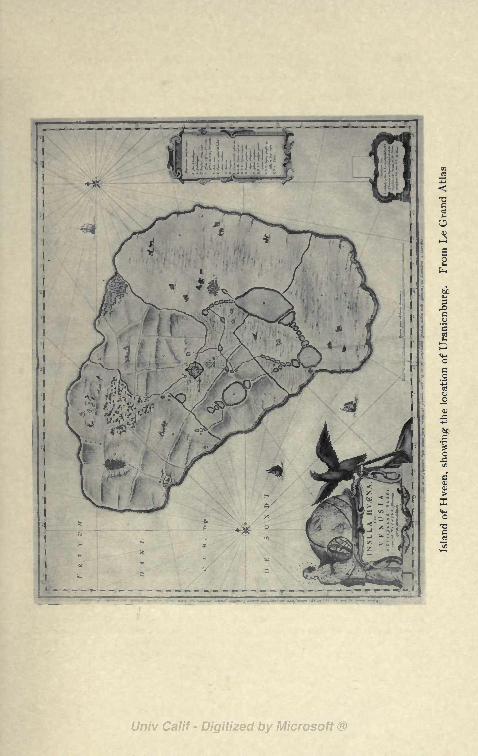
Island of Hveen, showing the location of Uranienburg. From Le
Grand Atlas ,12
Press invented by Blaeu. From Johnson, J. Typographia ... 16
Interior of Tycho Brahe's Observatory at Uranienburg. FromLe Grand Atlas 30
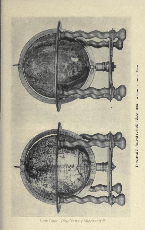
Terrestrial globe and celestial globe, 1616. Willem Janszoon Blaeu 44
World Map from Toonneel des Aerdrycx, by Willem Janszoon
Blaeu 52
Printer's mark of the Blaeu Press [tail-piece, page 59].

WILLEM JANSZOON BLAEU1571-1638

WILLEM JANSZOON BLAEUAND HIS
WORLD MAP OF 1605
WILLEMJANSZOON BLAEU, one of
Holland's most distinguished map and globemakers of the early seventeenth century, was
born at the village of Alkinaar in the year 1571; such is
the record which finds general acceptance.1
Of his childhood nothing is known. It was some time in
his early boyhood days that he went to Amsterdam, where
he found employment, it appears at first, in the house of a
Holland merchant, and later as a joiner's apprentice. Wecan be certain neither of the time when he decided to leave
Amsterdam, nor of the circumstances which induced him to
visit the island of Hveen, then belonging to Denmark,2 an
event of much significance in his life. We, however, can-
not be far wrong in asserting the promptings for this visit
to have been his early liking for mathematical, geograph-ical and astronomical studies. On this island he was
iAn exhaustive study of the life debtedness to Baudet's work for in-
and work of Willem Janszoon Blaeu valuable aid in the preparation of this
does not exist. One of great value and brief biography.interest is that by Baudet, P. J. H. 2 See illustration, p. 12. This, it
Leven en werken van Willem Jansz. will be noted, is a map signed "InsulaBlaeu, uitgegeven door het Provincial Hvaena sive Venusia a GviljelmoUtrechtsch genootschap van kunsten Blaev cum sum Tychone Astronomiaeen wetenschappen. Utrecht, 1871. operam daret delineata."The author acknowledges here his in-
11

brought into intimate relations with Tycho Brahe, the
famous Danish astronomer, who, in 1576, established here
his observatory at the Castle of Uranienburg.3 For near a
quarter of a century, this was one of the most famous cen-
ters in all Europe for the study of astronomical science and
of its practical applications. Blaeu, let it be noted, was
not the first of the young Netherlanders who found his wayto Uranienburg that he might receive astronomical in-
structions from the great master. As early as 1591, Jacob
Florent van Langren of Amsterdam sent his son Arnold
to the Danish astronomer with a request that he might be
allowed to copy the catalogue of the stars which had been
located at his observatory, wishing to make use of the same
in the new celestial globes which he proposed to construct.
This special request, we are informed, was not granted,for Brahe's records were not yet complete, but young van
Langren was given permission to see the large celestial
globe which was in the observatory, and on which at the
time of the visit 800 stars had been represented.4
It is
3 See illustration, p. 30. taken from Brahe: Astronomiae in-
August 8, 1576, the corner-stone of stauratae mechanica. 1598.
the Castle of Uranienburg was laid 4 This great copper globe, whichwith much ceremony, and the comple- Picard describes as having a diametertion of the building was made possible of 4 feet 7 inches and 1 line, con-
through the generous contributions structed in Augsburg under the direc-
and patronage of Frederick II of tion of Paul Hainzel, appears to haveDenmark. See, for a brief description, been sent to Uranienburg about 1584.
Wolf: Geschichte der Astronomie, In the course of succeeding yearsMunchen, 1877, p. 277; Picard, J. more than one thousand stars were
Voyage d'Uranibourg, ou observations represented on its surface accordingastronomiques faites en Dannemarck. to the observations of Tycho Brahe.
(Mem. de I'Acad. royale des sci- In 1597 the great astronomer left Den-ences depuis 1666 jusque a 1699, torn. mark to find a home in Prague, takingVII, p. j?7); Blaeu: Atlas Major, with him his astronomical instruments,vol. I, pp. 61-101. Twelve illustra- including his celestial globe. Aftertions of the Island of Hveen, and of Brahe's death in 1601, these instru-
the observatory of Uranienburg, with ments were purchased by Rudolph II,
brief description, may here be found. but on the capture of the City ofThese illustrations, it appears, were Prague in 1623 by the Danish Prince
12


stated that Tycho often had as many as ten or twelve boysat his observatory as his assistants.
We have but little direct information concerning Blaeu's
sojourn at Uranienburg. It appears certain that he passedat least two years with Brahe, engaged the while in studyand in the construction of mathematical and astronomical
instruments. May 21, 1596, the day of the young Holland-
er's departure for his native land, Brahe made the follow-
ing entry in his day-book, which book may be found in the
Imperial Library of Vienna, "Abiit domum in JEollan-
diam, Vilhelmus Batavius cum per integram hyemen his
fuisset," and by Gassendi we are told that Guilielmus
Janssonius had been with Tycho for two years, althoughhe does not make it certain that it was for two consecutive
years. That the relations between the two distinguished
scientists continued to be of the most friendly character
long after the date given above is very certain, as not a few
of those who in later years in praising Blaeu's scientific
attainments refer to him as "the pupil and longtime friend
of Brahe," yet neither of them appears in his writings to
have made more than a passing allusion to their relations.5
It cannot be doubted that Blaeu owed to his abode on
the island of Hveen the real foundation of his scientific
knowledge, both in the field of geography and of astron-
omy, as well as his knowledge of the construction and the
skilful use of mathematical instruments. We have reason
for believing that a number of the instruments which
served the great astronomer in his investigations, were the
Ulrich the globe with other objects of 5 John Blaeu, son of Willem, tells
interest was taken to Copenhagen. us that in 1591 his father was amanu-Here it remained until 1728, when it ensis of Tycho Brahe. See Blaeu: At-was destroyed by fire together with las Major, 1662, vol. I, p. 63.
the castle in which it had so long been
kept.
13
work of Blaeu, and it is an interesting fact, as we 1
that Brahe's observations, here made, formed the has
Kepler's calculations, leading him to the discovery (
laws which immortalized his name.
It was perhaps late in the year 1596, or early in
that Blaeu returned to Amsterdam where he soon <
lished himself as a maker of mathematical instrumen
maps and of globes, and as an engraver and printer.
Before the close of the seventeenth century, the N(
lands had moved into the first rank of European sta
which the art of engraving and of printing flour
Nothing perhaps contributed more to this end, espe
in the north, than the freedom which there prevails
trammeled by the restraints of the Index.
As for the particular art of map engraving and
printing, the work of Mercator, of Ortelius, of Wnaer, had centered the attention of those interested ii
field upon the Low Countries. As early as 1541, r
mention his work of the preceding decade, Mercator i
his terrestrial globe gores, which mark a decided ad
in the art of map engraving, and this was followed 1
large map of England, of Europe, and of the Worl<
latter setting forth the new method of projection
known as Mercator's projection. Ortelius's great we
1570, with its numerous succeeding issues, WagheiMirror of Navigation of 1585, and Mercator's bo<
maps of 1585, for which collection as a title the name .
was first used, were superior productions, models for
who followed closely within the same field.
Blaeu acknowledged these men to be his masters, th<
as was also frequently the case with other map maker
map engravers of his day, he occasionally forgot to a
14

proper credit to those from whom he borrowed in the car-
tographical work that issued from his press.
We are told that Tycho had given to Blaeu a copy of
his astronomical observations before their publication,
that this copy was carried to Amsterdam, and that on the
record contained therein the latter began the practice of
globe making. The implication contained in this refer-
ence is that his first work as a globe maker was the prepara-
tion of material for a celestial globe, but no such globe of
his is known bearing date earlier than 1602. His first
dated work appears to have been a terrestrial globe of the
year 1599. It was as a maker and vender of mathematical
instruments, as a collector and close student of maps geo-
graphical and astronomical, he probably found his chief
employment during the first years after his return to the
Netherlands. There is good reason for thinking that from
the first he prospered in his undertakings, and that he was
soon in a position to establish an independent business. It
may be inferred from incidental references that it was not
long after 1600 he was in his own fully equipped house
engaged in the business of engraving and printing.
Blaeu seems not to have become a member of any of the
guilds in his adopted city, and we, therefore, cannot turn
to their records for any information concerning his activi-
ties. His name first publicly appears in the records of the
States General for the year 1605, in a resolution proposingthat a sum of money should be granted to him for printingand publishing a NIEUW GRAETBOUCK, a name given at
that time in the Netherlands to a book containing declina-
tion tables. This resolution reads as follows: "19 Maart1605. Is Willem Jansz Blaeu tot Amsterdam geaccor-deert octroy, omme voor den tyt van 6 jaren naestcomende
15

alleene in de vereenichde provincien in druck vuyt to geveneen bouxken, geintituleert: Nieuw graetbouck, nae den
ouden styl vuyt de aldercorrecste observatien van den ver-
maerden astronomo Tycho Brahe, gecalculeert ende ge-
stelt op ten meridiaen deser Nederlanden, enz."( A copy
of this work does not appear to be extant, but we may be
able, as Baudet suggests, to obtain something of an idea
of its character from later publications of Blaeu, as for
instance from his "Licht der Zeevaert."
On his "Paescarte," one of his early publications, and
usually referred to the year 1606, we read that it was "Ghe-
druckt t5 Amsterdam bij Willem Janssoon op't Waeter
inde Sonnewijser," a location often referred to in certain
later publications as "op' t water In de vergulde Sonne-
wyser," reference being to the gilded sun-dial which as a
business sign adorned the gable of his establishment. 7 It
appears that in this originally selected locality his work
was carried on until the year 1637, when his entire plantwas moved into more commodious quarters in the Blumen-
gracht, one year only before his death. On the death of
Willem Blaeu, in 1638, the business passed into the hands
of his sons John and Cornelius Blaeu. In 1672 practically
the entire establishment was destroyed by fire.
For his ability and attainments as a practical printer
Willem Blaeu is especially entitled to great honor. He
6 Given by Baudet, p. 154- resented as the heavier and having the7 On the title-page of many of the word "Praestat" printed below it. In
books published by Blaeu, as on many certain later publications this markof the maps which he issued, appears was replaced by an armillary sphere,the expression "Sub signo solarii deau- at the left of which is an allegoricalrati." Most of the works printed by figure representing Time and on the
Blaeu before 1619 have as his print- right a figure representing Hercules
er's device a balance with a terrestrial with the inscription "Indefessus
globe in the right scale and a celestial agendo." See p. 59.
globe in the left, the latter being rep-
16

PUEH8 INVENTED BY BLAEW.
From Johnson, J. Typographia


labored on for many years in Amsterdam, making use of
such presses as were commonly to be found in the printing
houses of his own and of other lands. Finding, however,
numerous inconveniences attending the structure of these
oldtime presses, he was induced, about 1620, to contrive
remedies. 8 In this, we are told, he succeeded beyond his
expectations, so much indeed that he had nine of the new
presses constructed, each of which he called by the nameof one of the Muses. The excellence of Blaeu's improve-ments soon becoming known to other printing houses, their
proprietors were induced to follow his example, and presses
of his design became, in the course of a few years, almost
general throughout the Low Countries, and were intro-
duced into England, though at first there was here much
opposition to his new ideas. While the description below
is that of the Blaeu establishment as it was under the man-
agement of the son John, yet as it presents to us the print-
ing house founded by the father, Willem Blaeu, and
describes a printing house of the middle of the seventeenth
century, it is here cited in free translation.
"On the Blumengracht," says Filips von Zesen, in his
description of the city of Amsterdam,9 "near the third
bridge, and the third alley, may be found the greatly re-
nowned printing house of John Blaeu, Counsellor and
Magistrate, of this city. It is furnished with nine type
presses, named after the nine Muses, six presses for copper-
plate printing, and a type foundry. The entire establish-
s See, for brief descriptions of graphia, or the Printer's Instructor.
Blaeu's press, Stower, C. Printer's London, 1824, vol. II, pp. 500-551. It
Grammar. London, 1808, pp. 303-304; is from this last named work that il-
Hansard, Typography: an historical lustration p. 16 is taken.
sketch of the origin and progress of Filips von Zesen: Beschreibungthe art of printing. London, 1825, p. der Stadt Amsterdam, 1664, PP-550; and especially Johnson, J., Typo- 216.
17

ment on the canal, with the adjoining house, in which the
proprietor lives, is 75 feet in breadth, and stretches alongthe east side of a cross street 135 feet, or with the attached
house 150 feet. Fronting on the canal is a room with cases
in which the copper plates are kept, from which the Atlases,
the Book of the Cities of the Netherlands and of foreign
countries, also the Mariners' Atlases and other choice books
are printed, and which must have cost a ton of gold. Nextto this first room is a press room used for plate printing,
and opening upon the cross street referred to above is a
place where the type, from which impressions have been
made, are washed;then follows in order the room for book
printing, which resembles a long hall with numerous win-
dows on either side. In the extreme rear is a room in
which the type and certain other materials used in printingare stored. Opposite this store room is a stairway leadingto a small room above which is set apart for the use of the
proof-readers, where first and second impressions are care-
fully looked over, and the errors corrected which have been
made by the typesetters. In front of this last designatedroom is a long table or bench on which the final prints are
placed as soon as they are brought from the press, and
where they are left for a considerable time. In the storyabove is a table for the same purpose just indicated, at the
extreme end of which, and over the room occupied by the
proof-readers, is the type foundry wherein the letters used
in the printing of the various languages are moulded.
The foundation of this splendid building was laid in the
year 1636, by John Blaeu's oldest son Willem Blaeu,10
and on the 13th of the fall month of the following year the
10 John Blaeu's oldest son Willem it perhaps points us to an interestingwas at this time about one year old. exhibition of parental pride.If the statement by Zesen is correct,
18

printing establishment was here set in order. The original
founder of the printing house, who died in the following
year, was John Blaeu's art loving father Willem, who, for
a considerable time, had been a pupil of the great astron-
omer Tycho Brahe, whom he zealously followed, construct-
ing many instruments for the advancement of astronomical
studies, for the promotion of the art of navigation, and of
other sciences of like character, an interest in all of which
he revived and furthered while at the same time he madenew discoveries, as has become widely known from the
publications which have issued from this printing house.
But why should we here give to them such unbounded
praise? Since father and son without eulogy from us are so
well known to the entire learned world, to which they have
presented such treasures of inestimable value through their
incomparable pains and at great cost, and are so far ad-
vanced on the road to immortality, it is more becoming in
us to remain silent than to speak further concerning them."
Before turning for a reference more in detail to the pub-lications which were issued by the Blaeu press, to a con-
sideration of Willem Blaeu's most important work as
engraver, as globe maker, as printer and publisher of mapsand navigators' charts, a further brief word may be said
touching certain general interests and activities of his,
touching certain personal relations and individual charac-
teristics, which support the conclusion that he was a man
justly held in the highest esteem by men of science of his
day, and that he was interested in whatever pertained to
his great field of study.
Reference has been made to Blaeu's ability as a makerof mathematical and astronomical instruments, which workclaimed more or less of his attention to the end of his days.
19
The fact, however, is a very remarkable one that from the
many years of activity as an instrument maker with TychoBrahe, and independently at Amsterdam, but one exampleof his should have come down to us. Vossius says that "no
other scholar ever deserved so much praise as Blaeu on ac-
count of an extraordinary and beautiful quadrant, which
can be seen at Leyden in the tower, where astronomical
observations are being made." n His reference is to a quad-
rant now kept in the Leyden Observatory. It is described
by Kayser in his Annals of the Observatory as a wooden
quadrant, with a brass rim, having a radius of seven feet.12
In the year 1632 it was purchased from the estate of Wille-
brod Snellius, and may be said to have induced the found-
ing of this observatory in the year 1633.
With the conscientious map makers the problem was
ever present, how shall accuracy in space relations, accu-
racy in location of places on the map be attained. Ptolemyhad been a guide in the earlier years of great geographical
discoveries and explorations, but geographical knowledgesoon extended to regions beyond those known to Ptolemy,and the inaccuracies of his records, even for those regions
more or less familiar to the ancients, became very apparent.
In the maps of the seventeenth century we have interest-
ingly exhibited the tortuous advance of geographical
knowledge. They do not show a steady and continuous
progress toward accuracy. Information which may have
been accepted as truth respecting certain regions or geo-
graphical areas, and have been recorded as such by one or
by many of the map makers, would often be held as doubt-
ful by those of succeeding years, to be accepted and
rejected again in turn. Blaeu's intimate acquaintance
11 See Baudet, p. 15. 12 See Baudet, p. 14.
20

with mathematics and astronomy as related to geography,
particularly as related to cartography, admirably fitted
him for a certain leadership in this field. We have from
Vossius the information that Blaeu undertook the meas-
urement of a degree on the surface of the earth to the end
that he might aid the map maker in improving his work
and serve especially the cause of navigation. In his at-
tempts to find a new and better method for terrestrial
measurements, it seems probable that he anticipated the
work of the great mathematician Snellius, whose results
were first published in the year 1617, and to whom credit is
generally given for having employed a new method of
procedure based upon triangulation.13 Blaeu's measure-
ments, made along the coast of the Netherlands from the
mouth of the Meuse to the Texel, were never published,
probably for the reason, as suggested by Vossius, that he
may have distrusted their accuracy. The mathematician
Picard, in his Voyage d'Uranibourg,14
writes in the monthof July, 1671, a brief word concerning Blaeu's contribu-
tions toward the solution of problems having to do with
terrestrial measurements, giving us in this word practically
the only information we have concerning the matter. Ac-
cording to Picard, Blaeu's measurements gave results with
an error of but 66 meters, whereas for the same measure-
ments, Snellius's results gave an error of no less than 3880
meters. Had Blaeu more persistently carried on his studies
in this particular branch of mathematical geography, his
name doubtless would have been with the very first in a
list of those who have made contribution to the science of
is The report of this survey may be 1* Picard, J. Ouvrages de mathe-found in Snellius, W. Eratosthenes matique. A la Haye, chez P. Gossv
Batavus, de terrae ambitus vera quan- et J. Neaulme, 1731.
titate, a Willebrordi Snellio suscitatus.
Lugd. Batav., 1617.
21
terrestrial measurement and to a reform of the maps. His
aim was set in the right direction, and we are safe in sayingthat none, in his day, made greater contribution toward the
attainment of accuracy in map drawing than did he. Tobe able to understand the nature of the errors so commonin chart making and to be able to correct the same were
two very different matters, and although Blaeu was able
to point out many errors, such, for example, as pertainedto latitude and longitude, his maps do not indicate that he
was able to overcome all difficulties. His was not the dayfor scientifically accurate results. Years had yet to passbefore that end could be attained. To some of his errors,
and to certain improvements of his, attention will be di-
rected later. He appears to have been especially desirous,
at all times, of acquiring detailed geographical and astro-
nomical information from navigators who visited distant
regions, making request of them that their observations
should be reported to him. In a letter to W. Schickard,
dated June 24, 1634, Blaeu wrote, "When the directors of
the East India Company placed me at the head of their
department of hydrography a year ago, I requested themto charge all pilots and masters who sailed for India to
observe all eclipses, in whatever part they might be seen,
and this has been done." 15 His desire to be of assistance to
others in giving out such information as might come into
his possession is made evident by the further word in his
letter to Schickard assuring him that "if observations of
eclipses from India or other places on the way are sent to
me, I shall be pleased to inform you of them."
The determination of longitude, particularly at sea, re-
mained for more than a century and a half after Blaeu's
IB This letter is quoted by Baudet,pp. 172-174.
22

a most perplexing problem, a problem, however, of the
greatest significance in the art of navigation, miscalcula-
tions being often the cause of most serious disasters. The
rulers of the maritime states of western Europe not infre-
quently offered liberal reward for its solution. Philip III
of Spain, for instance, promised an annuity of 6000
ducats to the one who would first devise a method for deter-
mining longitude.16 Numerous attempts were made in
Spain and Portugal, as a result of the promised reward,
but the problem remained unsolved. The States General
of Holland, for instance, offered a liberal reward to Plan-
cius should a plan he submitted prove to be of value, which
plan he had based upon the declination of the needle ; and
in the records of that body, bearing date May 21, 1601, weread that a reward of 150 pounds was promised to any one
who, having made an expedition for the purpose of deter-
mining longitude and latitude, could obtain the support of
six or eight sea captains that his method was of real value. 17
Blaeu often figured somewhat conspicuously as an expertin passing upon the solution of certain problems which
were offered. Resolutions of the States General, for exam-
ple, make mention of a plan submitted by Thomas Learner,
an Englishman residing in Amsterdam, but it appears that
no satisfactory agreement could be entered into with himon his first plans, and it was, therefore, decided to submit
his subsequent propositions to the College of Admiraltyof Amsterdam, authorizing this body to ask for a demon-stration of the new invention in its presence, to have it
investigated by Willem Jansz. Blaeu and other masters
is See Lelewel, J. Geographic du if See De Jonge, J. K. J. De op-Moyen Age, Bruxelles, 1852-1857, vol. komst van het Nederlandsch gezagII, p. 194. in Oost-Indw, 1862-1909, vol. I, pp.
88-89.
23

in this art together with such experienced navigators and
pilots as the College might see fit to choose, to examine it
carefully and impartially with especial reference to its
practical value, and to follow their best judgment as to the
advisability of attempting to make use of the invention. 18
On July 3, 1612, the Council of the Admiralty sent word
to the States General that the aforesaid Learner had been
examined, in accord with the letter of December 21, 1611,
at different times, and at his request again and again in its
presence, by "Willem Jansz," and by many other persons
experienced in mathematics and navigation, in order to
find out the truth relative to his proposition ;that they had
charged the judges to examine honestly, and that it had
been unanimously concluded the invention was wholly
worthless.19 It is not without interest to note that Learner
made an especial appeal to the Admiralty of Amsterdam,
charging the committee with partiality and with inability
to judge the case, but we are not informed that the Ad-
miralty altered its opinion.
Taking into consideration the extensive commerce and
interest in navigation of the United Provinces in this pe-
riod, it does not occasion surprise that Galileo, after havingoffered in vain to Philip III his plan for a new method of
determining longitude, should decide to present the same
to the States General of the Provinces.20 This plan he
based upon his discovery in 1610 of the satellites of Jupiter
and the valuable data furnished him through a study of
is See Baudet, p. 18. be found in Kastner, A. G. Ge-19 See Baudet, pp. 18-19. schichte der Mathematik, 1796, vol.
20 Reference to Galileo and his at- IV, p. 207; Galileo Galilei: Opere,
tempts to solve the problems relative III, p. 1^2; Baudet, pp. 131-145.to the determination of longitude may
24

the eclipses of these satellites. Galileo himself tells us of
his negotiations with Philip of Spain, stating that the Kinginformed him of the many inventions which had been sent
to him, and which he had accepted, only to find afterward
that they were of no practical value. Having been so often
deceived, he had come to the conclusion that a great deal of
money had been wasted, and had, therefore, decided to be
more careful in future. It was not until August, 1636,
that Galileo decided upon presenting his plan to the States
General, as he informed Hugo Grotius, then Swedish con-
sul at the French Court, and not until November of that
year that Laurens Reael handed to the States a letter from
him containing an explanation of his method, with an offer
of the plan to that distinguished body. Blaeu is againchosen as one of four experts to examine and report on the
invention. Galileo's plan was well adapted for the deter-
mination of longitude on land, but because of the ship's
motion on the high seas it did not prove to be practical
for navigators, though he suggested the placing of his
instruments and the observer in a vessel of water on the
ship's deck, thinking thus to counterbalance the ship's mo-
tion. By resolution of April 25, 1637, he was to receive
a reward for the new method he had suggested, but it does
not appear that it was paid to him.
Blaeu's training admirably fitted him to serve his coun-
try in matters pertaining to its maritime interests, and its
calls as well as its rewards for his services were not infre-
quent. As further proof of the confidence that his con-
temporaries had in his knowledge of geography and
navigation, the States General of Amsterdam, January 3,
1633, by resolution appointed Blaeu map maker of the
Republic, an honorable position held by him until his
25

death, being then successively passed on to his son and to
his grandson. In a resolution of October 23, 1666, we read
that no house engaged in commerce will be allowed to send
any marine maps to India, or have them taken by captains
of vessels, except those made by Blaeu; and in a resolution
of 1670 it is stated that to Willem Jansz. Blaeu, mapmaker in ordinary of the Company, instruction has been
given to examine the journals of the pilots and to correct
and improve the maps.It is not easy at this date to determine the justice of the
several complaints which we find were occasionally made
by certain map makers of the Netherlands in the early
seventeenth century against fellow countrymen. There
was so much borrowing one from the other without credit
that it would be an exceedingly difficult, if not impossible,
task to give a complete catalogue of any one of the several
map makers' work. Rivalry often ran strong, and the
authorities not infrequently were urged to exercise special
diligence to prevent the infringement of a copyrighted
plate, or one that was protected, as they at that time ex-
pressed it, by an octroi. Between Willem Blaeu and
Joannes Janssonius this rivalry was particularly marked,each claiming at times an infringement by the other.
Whether it was for protection against Janssonius that
Blaeu in 1608 presented a special plea to the States of
Holland and West Friesland, asking that he be madesecure against the loss caused by pirated editions of works
published by him, is not certain. He informed the States
that he had given himself hope of being able to support his
family in an honest way, and that he would have succeeded
with God's mercy and blessing, if certain individuals en-
gaged in the same business had not undertaken to copy his
26

new works, as well as his enlarged and improved works.21
This rivalry between Blaeu and Janssonius continued for
many years, involving in some degree Jodocus Hondius,
the father-in-law of Janssonius. It seems probable that
Blaeu's complaint of 1608 touched in some manner his
large World Map of 1605, since, as before stated, there is a
striking resemblance between this and the World Map of
Hondius issued about 1611, on which he must have been at
work for some years, a similarity in which the very differ-
ences and slight variations cannot be without peculiar sig-
nificance.22
If Blaeu won deserved renown through his scientific at-
tainments, so the Blaeu press became renowned for the
excellence of the work which bore its imprint. Its mapengravers were among the most skilful employed in the
workshops of the Netherlands, its types were unexcelled in
simple but artistic form, unless perchance one may accord
first place to the Elzevir press. His good work, as we
know, was a spur to others, as, for example, to Hondius
and Janssonius in the issue of their Atlas of 1633.
The list of works which issued from this famous printinghouse in so far as we have accurate information, is an ex-
ceedingly long one, and the titles include many which do
not touch upon matters geographical, hence do not call for
consideration in this brief sketch. We may, therefore, passto a more detailed word concerning those works which bear
particularly upon geography and navigation, to his mapsand globes.
21 See Extract uit de Resol. der to some of the many striking similari-
Staten van Holland en West-Vries- ties, which seem to give conclusive evi-
land, 5 Aug., 1608, given by Baudet, dence that Hondius borrowed from
pp. 156-158. Blaeu.22 See p. 58 for specific reference
27

IT does not seem possible at this date to enumerate all
the maps which might properly be called the special work
of Blaeu, and it is doubtful if it could have been done in
Blaeu's day, since he so often borrowed here a little and
there a little which he incorporated in his maps. Refer-
ence has before been made to the practice of map makers
borrowing one from the other, sometimes more, sometimes
less, without credit. Not all of Blaeu's maps are signed,
and but comparatively few of them are dated. He did not
consider it essential always to employ the same name when
affixing his signature. Sometimes he gave his name as
Guilielmus Janssonius Blaeu, Guil. Jansz. Blaeu, Guilj el-
mus Blaeuw; sometimes as Guil. Jansz. Alcmar, Guiliel-
mus Janssonius Alcmarianus; sometimes as Guiljelmus
Caesius, or G. J. Caesius, in which, in accord with a prac-tice of the time, he had classicized his name Blaeu; some-
times the name is coupled with that of the son as Guil. et
Johan. Blaeu, and on certain maps we find the names J. or
Joan. Blaeu, Johannes et Cornelius Blaeu, maps which
were wholly or in part the work of the sons, but were
drawn after the manner of the father.
Next to his terrestrial globe maps of 1599 and 1602, his
oldest known map is that of 1605, here issued in facsimile,
and described below. His "Nywe Paskaerte" of 1606, of
which but few copies are now known, appears to have been
the first which he especially designed for navigators. Bau-
det gives a somewhat enthusiastic description of a copy of
this map printed on parchment, which at the time of his
writing was in the possession of Mr. Tiele.23 It is drawnwith the west at the top, having a width of 76 cm. and a
23 See Baudet, P. J. H. Naschrift op. Leven en werkenvan W. Jz. Blaeu, pp. 15-18.
28

breadth of 59 cm., extending from 25 30' to 75 north
latitude, or from the Canary Islands on the south to the
Beeren Island on the north, from Terceira on the west to
and including the Ionian Islands on the east. In a car-
touche at the bottom of the map is the following inscrip-
tion, given here in free translation:24 "Willem Jansz. to
the kind reader : In this map, dear reader, you will find all
the sea coasts of Europe carefully drawn by Cornelius
Doedsz. of Edam, according to true directions and eleva-
tions, except for the Mediterranean, in which the author
has purposely omitted the elevations from Malta eastward,
and has only given direction, according to our commonDutch compasses, which, in the vicinity of Candia and
Cyprus point a little too much toward the northwest, as is
shown by the fact that Malta, the south shore of Candia
and of Cyprus are all situated in latitude 36, although it
is impossible to reach them sailing west-east, as this mapclearly shows." To the right of the above inscription weread: "Ghedruct t' Amsterdam bij Willem Janssoon op'tWaeter inde Sonnewijser," and to the left, given here in
translation: "Since on account of the limited space the
entire Mediterranean Sea could not be given, we have
therefore decided, for the use of seamen, to add also the
part from the coasts of Barbary, Sicily, and Malta, passingthe Grecian Islands, Candia, and Cyprus to the coast of
Syria." Of the two small inset maps, one represents the
Azores, the other the Beeren Island and the west coast of
Spitzbergen. The eastern part of the Mediterranean,Greece and the Ionian Archipelago, the coast of AsiaMinor and Syria, have been placed in the Sahara Desert.
24 The inscriptions in the original Dutch are given byBaudet: Naschrift, pp. 16-17.
29

Longitude is not indicated, but latitude is given on the
border, each degree being divided into thirds. In this mapnorthern Europe is brought too far to the west, and, in
accord with the general representations of the time, the
Mediterranean is given too great an extent in longitude.
The errors in latitude are comparatively insignificant. Asone of the first examples of the work of Blaeu's printing
house, it is deserving the special mention given above, par-
ticularly so by reason of the distinctness of its boundarylines, the excellent form of its letters, and the care with
which geographical details have been indicated.
A resolution of the States General dated April 25, 1608,
gives us the information that to Willem Jansz., map maker
of Amsterdam, the sum of 200 gl. is to be given for the
dedication and presentation of a book of sea charts, entitled
"Het Licht der Zeevaert," which lays down the coasts and
harbors of the Western, Northern and Eastern Seas. In
this we appear to have first reference to Volumes I and II
of an important work by Blaeu, of which work a third vol-
ume appeared in 1621, protected by an octroi of the States
General for six years, expressed in a resolution bearingdate August 13, 1618.25 This resolution of the States in-
forms us that to Willem Jansz., a citizen of Amsterdam,an octroi is granted for the period of six years, to make,
print, and publish in the United Netherlands, the third
part of his book entitled "Het Licht der Zeevaert," con-
taining a description of the sea-coasts of the Mediterranean
Sea. Copies of the first two volumes, printed in accord
with the indication contained in the resolution referred to
above, that is, in 1608, appear not to be known, but there
exists a French edition of 1619, bearing the title "Le flam-
25 An extract from the Resolution is given by Baudet, p. 156.
30

Interior of Tycho Brahe's Observatory at UranienburgFrom Le Grand Atlas


beau de la navigation . . . Chez Guilliaume Jeansz. de-
meurant sur 1'eau, a 1'ensigne du Solaire Dore. 1'An 1619,"
which title is often found in the volume pasted over an
original Dutch title dated 1620. In translation this Dutch
title, being practically the same as that in French, reads,
"The Light of Navigation in which are plainly drawn and
described all the Coasts and Harbours of the Western,
Northern, Eastern and Mediterranean Seas. Also manycountries, islands and places of Guinea, Brazil, East and
West Indies. Partly taken from the works of the best
writers on marine matters [as Lucas Jansz. Waghenaerand others] but improved through the writings of experi-
enced seamen, and by making use of their statements and
explanations; enlarged by many new descriptions and
maps. All divided into four books, each volume having its
own index. Hereto have been added [besides a course in
the art of navigation] new tables of the declination of the
sun, derived from the observations of Tycho Brahe, and
calculated from the meridian of Amsterdam. Also newtables and instructions in the right use of the Pole Star and
other Stars, for the benefit of all navigators." In 1627 the
Dutch edition seems to have been issued by "Jan Janssoon
wonende op 't water," the first part being dated 1626, and
the second part dated 1625.
In the dedication of his third volume to the States Gen-eral and to Prince Maurice, a dedication dated September1, 1618, there is to be found a statement by Blaeu which
shows his own opinion of the importance of the first twovolumes. He writes he is "assured without boasting that
this third volume will be as useful as the two preceding,
containing the description of Eastern and Western Navi-
gation, of which Your Honorable Body [States General]
31

and Your Excellency [Maurice] at other times have had
sufficient proof from trustworthy certificates of well known
navigators, and also from the statements of the famous
pilot Lucas Waghenaer." To have from Lucas Jansz.
Waghenaer a favorable criticism concerning a work which
was destined to be considered superior to his own, is of no
little importance. Blaeu further acknowledges in his in-
troduction the influence of Willem Barentszoen's mapsupon his own, for he states "to the kind reader" that "we
have for some years past collected very carefully all obser-
vations and plans, by means of which we have improvedand enlarged in many respects the descriptions of Willem
Barentsz., whose writings have been of much value to us in
this work. Besides, we have added the descriptions of all
the sea-coasts in the east which were not laid down by him,
as of the islands of Candia, Cyprus, the coasts of Syriaand Egypt, and also of the Greek islands ; and how one in
this way can sail even to Constantinople ; and we have putthis all together." "The uses of this Book" he sets forth in
six brief introductory chapters, in which he treats of "1
The difference between the Dutch and the Italian marine
maps; 2 Why the compass needle is not laid directly un-
der the compass lily; 3 Why the marine charts of the
Mediterranean Sea are not drawn showing the degrees of
latitude; 4 How to reckon latitude; 5 How the declina-'
tion of the compass needle or the variation of the compass
may be determined; 6 How to find the elevation of the
sun from its shadow."
Blaeu's reference to the declination of the needle in this
introduction is of considerable scientific importance and
interest. In his day the compass makers found the needle's
declination for Holland to be from about 7 45' to about
32

8 26' eastward. They were, therefore, accustomed to lay
the compass lily a corresponding number of degrees to the
left or westward from the direction in which the needle
pointed that this lily might turn to the true north. Hefound that in the Adriatic the declination of the needle
was 0, and that in the Italian compasses the direction of
the needle and of the lily agreed. Compass roses on Italian
portolan or sailors' charts, therefore, indicated no declina-
tion as the Italian compasses indicated none, and the com-
pass lily simply marked the true meridian. As distances
to be sailed in the Mediterranean were not great, latitude,
therefore, was not laid down, and longitude was omitted,
by reason of the fact that there was no accurate method of
determining the same, consequently vessels sailed from
port to port directed only by the compass. Blaeu wrote
that "since the skies are there [in the Mediterranean] al-
most always clear, and the land high, and places are not
far distant one from another, one losing sight of one partof the coast will be in sight of another part, and the major-
ity make very little use of latitude. The seamen and those
who have navigated these parts have not taken into con-
sideration the latitudes, and follow only general direction."
This being Blaeu's observation, which is practically taken
word for word from Barentszoen's introduction to his
"Caertboeck," one would not, therefore, expect to find
either parallels or meridians laid down on his maps. Hegives only compass roses and direction for sailing in accord
with the Dutch compass. On the maps of Barentszoen,
which maps Blaeu closely followed in many respects, the
directions for sailing are given in accord with the Dutchand with the Italian compasses. Blaeu could not have, fol-
lowed a better master in plan and purpose, and while not
33

always indicating just what he borrowed, he seems to have
been inclined to give adequate praise to the work of his
predecessor. It cannot be without interest to cite here a
brief word from Barentszoen's introduction to his "Caert-
boeck," as indicating his spirit and method. He says "that
not only being urged by my many good friends, but also
feeling inclined myself to do so, since I always have been
accustomed from my boyhood up to draw as many mapsas I found it possible to draw of the countries which I vis-
ited, or around which I sailed, giving the seas, the waters
and the directions, I have decided to publish certain mapsof the sea-coast of the Mediterranean Seas [which I have
collected for some years past] into book form, for the use
and the benefit of all navigators, and persons interested in
navigation. In part, I describe what I myself have seen on
my journeys, in part what I have learned from other ex-
perienced navigators and pilots, who have sailed throughthe Strait of Gibraltar to Italy and the surrounding coun-
tries. And this I have carefully arranged, showing all
harbors, roads, bays, courses and directions ; giving myselfa great deal of trouble, and incurring a great deal of ex-
pense. Since I did not like to rely alone upon myself, I
invited to my home several seamen and pilots, who sailed
the Mediterranean Seas, with whom I have communicated
about my work. I made corrections whenever I found that
their observations had been more exact than my own, that
it might not seem as if I, being proud, intended to make a
name for myself, and as if I had done this work carelessly,
but that it should be clear I had gone to much trouble."
A resolution of the States General, dated March 9, 1623,
granted to Willem Jansz. Blaeu, for a period of ten years,
the exclusive right to print and publish a work referred to
34

in the resolution as "een compendium van den Zeespiegel."
It appears, however, that this was not issued until 1625,
and under the title "Tafelen van de declinatie der Sonne,
ende der voornaemste vaste sterren, Mitsgaders van 't
verscheyden gebruyck der Noordsterre Nieulycx, alien
Zeevaerenden ten dienst, ghecalculeert door Willem
Jansz. Blauw," or "Tables of the declination of the sun
and of the most important planets with the different uses
of the North Star calculated anew for the use of all navi-
gators by Willem Jansz. Blauw." On the title-page ap-
pears a representation of the cross-staff and the astrolabe,
with the imprint "f Amsterdam By Willem Jansz. Blauwin de guide Sonnewyser, Met privilegie, Anno 1625." Thestatement is made in the preface that "from the exact
observations of Tycho Brahe, we have calculated newtables of the declination of the sun." These same tables
are to be found in the Zeespiegel of 1627, and were in-
tended to replace the old tables of the "Nieuw Graetbouck"
of the year 1605.
A second privilege granted by the States General, dated
March 9, 1623, as the preceding, gives us the first word
concerning another work by Blaeu intended especially for
the use of seamen. This work, apparently not issued until
the following year, though a copy dated 1624 does not
seem now to be known, bears the following title taken
from the issue of 1627: "Zeespiegel, Inhoudende een korte
Onderwysinghe in de Konst der Zeevaert, en Beschry-
vinghe der Seen en Kusten van de Oostersche, Noordsche
end Westersche Schipvaert. Wt ondervindinghen van
veel ervaren Zeevaerders vergadert, en t' samen ghestelt.
Door Willem Jansz. Blaeuw Tot Amsterdam. Ghedruckt
by Willem Jansz. Blaeuw, in de vergulde Sonnewyser
35

1627. Met Privilegie voor thien Jaren"; or, "Mirror of
the Sea, containing brief instruction in the art of Naviga-
tion, and a description of the seas and coasts of the East-
ern, Northern and Western Navigation. Collected and
arranged from the experiences of numerous Navigators.
By Willem Jansz. Blaeuw, At Amsterdam. Printed byWillem Jansz. Blaeuw, in the gilded Sun-dial, 1627. Witha privilege for ten years."
Blaeu figures his declination tables from the years 1624,
1625, 1626 and 1627, on a parallel of the earth from the
meridian of the west point of England, since this longitude
was most frequently used by the Dutch navigators in sail-
ing the Channel, as well as in sailing the coasts of France,
Portugal or Spain. The work is divided into two parts,
the first being a short treatise on the art of navigation, and
the second a collection of maps or sea charts. We have in
this work a striking illustration of the lingering influence
of Ptolemy, for he takes as a basis of many of the ideas he
presents the work of Ptolemy. The book does not under-
take, as Baudet points out, to add to or improve the
methods of defining geographical location. It does not
undertake to correct what were the known errors in his
day. He treats in his first part of the several spheres; he
presents what he considers to be acceptable proof that the
earth is in the center of the universe, as the stars appear at
all times to be of the same size, in whatever part of the
heavens they may be ; he explains the construction and the
use of the cross-staff by means of which the observer de-
termines the altitude of the sun; he points out that in deter-
mining latitude by observing the altitude of the Pole Star,
2 42' should be taken as the distance from the star to the
pole; he discusses the subject of atmospheric refraction,
36

basing his observations on those of Tycho Brahe, which
discussion is of special interest since it sets forth the atti-
tude of seamen of that day toward this subject, and the
difficulty they had in meeting it by reason of the imperfect
instruments with which they made their calculations.
Blaeu's charts are drawn on a plane or cylindrical pro-
jection, although the projection of Mercator had been
known for more than half a century. This fact seems to
suggest the idea that in publishing his book he had not so
much in view the question of the advance of the art of
navigation as to meet a desire for a work in agreement
scientifically with the knowledge of seamen of his day. In
point of accuracy, Blaeu's charts in this work are wanting
much, but we must not forget the imperfect methods em-
ployed in his day for obtaining geographical location. If
accuracy was wanting in the land maps, much less could
we expect to find accuracy in the marine charts. Seamen
in part were accustomed to estimate longitude and distance
from change in latitude, and the direction in which theysailed. The speed of a ship was often estimated from the
size and the number of sails used. It was not until about
the middle of the seventeenth century that the log was
brought into common use, consequently Blaeu makes no
reference to it. It is interesting to note that a somewhat
similar instrument was employed about the middle of the
sixteenth century for measuring the angle which the axis
of the ship made with its track as observed on the surface
of the water. In his "Spieghel der Zeevaert" of 1584,
Waghenaer states that for measuring this angle, "it is nec-
essary to let the plumb line log behind with a piece of woodattached or otherwise." A comparison of the maps of
Blaeu with those of his distinguished predecessors, Lucas
37

Jansz. Waghenaer and Willem Barentszoen, warrants our
assigning to him first place, both in point of execution
and in the nearer approach to correctness in his drawing.John Blaeu, in his Atlas of 1664, referring to the maps of
Waghenaer and Barentszoen, says that "my late father
not only greatly improved both of these, but also enlargedthem for the benefit of navigation, adding to them so muchthat was lacking that his may justly be called a new work."
In 1646, John Blaeu printed a fourth part of the Zee-
spiegel, bearing the title "Vierde deel der Zeespiegel, in-
houdende eene beschryvinge der See-havenen, Reeden, en
Kusten van de Middelandsche Schipvaert. Uyt onder-
vindingen van vele ervaren Zeevaerders by een vergadert,
en t' sameiigestelt, door Willem Jansz. Blaeu, t' Amster-
dam. Gedruckt by Johan Blaeu, op 't Water, in de ver-
gulde Zonnewyser. 1646," or "Fourth Part of the Mirror
of the Sea, containing a description of the Harbors, Road-
steads, and Coasts of the Mediterranean Navigation.Collected from the experiences of famous Navigators, and
arranged by Willem Jansz. Blaeu at Amsterdam. Printed
by John Blaeu on the Water in the gilded Sun-dial, 1646."
There is included in this fourth part the third part of the
"Licht der Zeevaert" of 1621, with the arrangement of the
contents and the size of the volume somewhat altered. That
which is true of certain map publishers in this day, in their
attitude toward their own publications, was true of the
publishers of these Willem Blaeu maps after his death. So
long as there were publishers for them, it was not thoughtto be necessary to improve them, especially so since John
Blaeu, who had succeeded his father in charge of the busi-
ness, had taken up what he thought to be more profitable
printing than the issue of charts for seamen. Other pub-
38

lishers, after the middle of the century, were entering the
field, and the Blaeu marine maps in course of time came to
be regarded as obsolete.
What we may call his first Atlas of land maps appearedin 1631, with the title "Appendix Theatri Ortelii et Atlan-
tis Mercatoris." It contains maps which had been pre-
viously issued, some by himself, many by other map mak-
ers, while in numerous instances he left it difficult to decide
both date and origin. We know that as early as 1605 he
was issuing maps and charts in single sheets, following the
example of Ortelius, Mercator, Judeus and others. Bau-
det, it may be noted, expresses himself as being unable to
decide whether the World Map of 1605, referred to in the
resolution of the States General of the 23d of April of
that year, was of this character, not knowing of the exist-
ence of a copy of the map here reproduced in facsimile
from that belonging to the Hispanic Society of America.
"My belief," he says, "is that the World Map of 1605 is
the Nova totius terrarum orbis geographica ac hydrogra-
phica tabula, auct. Guiljelmo Blaeuw," according to Mer-cator's projection, to be found in the "Toonneel des
Aerdrycx."26 Not unlike Ortelius, Blaeu often selected
for addition to his own original land maps the best which
he found it possible for him to use, redrafting them on a
scale to fit his own Atlas. In general, he greatly improved
26 Baudet says: "I am unable to de- tor's projection, to be found in the
termine whether the World Map of 'Toonneel des Aerdrycx.' It is not
1605 and the Mappa Mundi, in two dated, but apparently was printed
hemispheres, of that year, as referred from a plate which had been used in
to in the resolution of the States 1606, though improved somewhat, but
General, are the same. I believe, how- from it the date had been erased, which
ever, that the World Map is the 'Nova however, according to Lelewel, is
totius terrarum orbis geographica ac slightly visible "on some copies." See
hydrographica tabula, auct. Guiljelmo Baudet, pp. 85-86. The "Nova totius
Blaeuw,' drawn according to Merca- terrarum" is reproduced, p. 52.
39

their character by his own re-engraving, giving us maps of
superior excellence in line, in letter, and in ornamentation.
He was not unmindful of the high favor in which the
Atlases of Ortelius and of Mercator were held. He, there-
fore, shrewdly calls attention to their work by giving to his
own a title which suggests a connection, though in fact he
was scarcely justified in calling his Atlas an Appendix to
Ortelius and Mercator. This Atlas of 1631 contains one
hundred and three maps, with text in Latin usually printedon the back of each. Seven of his maps are dated, twenty-seven have the names of the original maker, and many of
them are signed Guilj. Blaeu, G. J. Caesius or GuiljelmusJanssonius et Joannes Blaeu.
He begins his preface with much praise of Ortelius and
Mercator, observing that Mercator died untimely for his
work, after finishing Europe except Spain, and he as-
sumes it as his task to publish an Appendix to the Atlases
of these great men. He states that his Atlas will contain
maps of countries already drawn by them, but he promisesto improve them. That he did improve not a few of them
is made evident by a close comparison, yet he left manyfeatures uncorrected, which easily could have been broughtto date.
He often intimated to his friend, W. Schickard, his ever
present desire to improve his maps, in which references wefind the first promises of his work issued in 1634 under the
title "Toonneel des Aerdrycx." In a letter dated Amster-
dam, November 22, 1633, he tells his friend of his prepara-tion for this new Atlas,
27expressing the hope that he
would be able to complete the first part during the winter,
and accepting from him an offer for a new map of Wiir-
2T See Baudet, pp. 96-98, for extracts from his letters to Schickard.
40

temberg, for which he was ready and willing to pay the
price asked. This map he thought would add much to his
maps of Germany. December 6, 1633, he writes again to
Schickard: "The esteemed gentleman, Hugo Grotius, has
informed you that I am planning a new Atlas, and that a
considerable part of it is already completed, in addition to
my Appendix Theatri Ortelii et Atlantis Mercatoris,
which has been published, so that I will be able to issue yet
this winter two parts of reasonable size, one part of which
will contain maps of upper and lower Germany, and as I
should like to add this map of Wurtemberg which youhave drawn, and which you have promised me, I therefore
wish to postpone the publication a little longer. Youwrite that this map of Wurtemberg which you have drawn
on twenty sheets can be reduced to four of common size.
If, however, you deem it better to make use of more sheets,
you may follow your pleasure. Whatever your decision, I
will pay the price which you ask for it." On January 12,
1634, Blaeu writes Schickard again: "I am pleased to
learn you agree with my opinion in regard to the number
of maps. It is my intention to place two or three provinceson one sheet, but it will be necessary, however, to leave some
open space in which I can write the titles of the maps, arms
of the country, and the scale of miles. Do not let this worry
you, however, but follow the divisions which are most easy
for you. In the case of maps so carefully drawn, it seems
to me the larger the number, the better it will be. Forests,
buildings, etc., may be but roughly marked. If you will
give the size and exact location, I will take care that the
emblematical figures are properly represented"; and he
adds that "in order to make sure that the completed work
is well done, I shall let you correct the plates one at a
41

time." Somewhat later Blaeu writes again that "I shall
give especial attention to the engraving of the plates,
printing lightly from them at first, in order that changes
may be made before the final engraving is done. . . . Takeas much time as you may need, and in case you are un-
able to finish them during the summer, you may also have
the winter." June 24, 1634, he writes to Schickard: "I
have published the first part of my Atlas, containing one
hundred and sixty maps, with descriptive text in Ger-
man, translated from Latin. In the Fall I shall publishthe Latin, French and Dutch texts," these titles being, re-
spectively, "Theatrum Orbis Terrarum," but dated 1635;
"Le theatre du monde ou nouvel atlas," but issued in 1634;
"Toonneel des Aerdrycx," 1634. The arrangement and
number of maps in the several issues do not agree, but in
the main features they are the same. The "Toonneel" maybe considered an enlargement of his "Appendix" done in
practically the same manner, but with the addition of
numerous details, and ornamented with additional illus-
trations. That he borrowed from the "Nieuwen Atlas"
of Joannes Janssonius and Henricus Hondius becomes
evident in a comparison of the descriptions of "Germany,"the "Netherlands," and of certain other parts.
The "Appendix" and the first two parts of the "Toon-
neel," published by Willem Blaeu and his son John, maybe regarded as the beginning of the large Blaeu Atlas first
issued in 1662 in eleven volumes, a work of unsurpassedexcellence ; indeed, we may refer to it as the foremost atlas
produced by the great Dutch atlas makers of the seven-
teenth century. Its completion and issue, after the death
of the father, Willem, places it therefore without the scopeof this sketch, yet as he had contributed so much to insure
42
its success by his own early activities, a word of reference
to it is here fitting. Editions of this work appeared in
rapid succession in the Dutch, the French, the Latin and
the Spanish language, the number of volumes being either
nine, ten, eleven or twelve in each edition, varying other-
wise but little in the essential features. As numerous copies
of the work were printed in each edition, it is therefore not
a publication which can be called rare even in this day.Most of these editions were printed from the superior typeand copper plates of the Blaeu printing house, and on
paper of fine quality ; some were issued in costly bindings,
having their maps, coat of arms and emblems of states and
of royalty exquisitely colored. Copies of the atlas were
especially prepared for rulers and for statesmen of re-
nown. We are informed that to Admiral de Ruyter an
especially fine copy was presented after the two days' bat-
tle of 1666, and that in the name of the States General a
copy bound in royal purple was presented to the Sultan
Mohammed IV, with which he was so well pleased that he
ordered its translation into the Turkish language.
IN Blaeu's day globes were held to be of the highest
value as aids in the study of geography and astronomy.28
Seamen engaged in transoceanic navigation counted on a
terrestrial and a celestial globe as essential to a navigator's
complete outfit of instruments, and as Blaeu was especially
desirous of making his scientific knowledge serve the cause
of navigation, it was but natural that he should turn his
attention to globe making.
28 See Fiorini, Matteo. Sfere Ter- Erd- und Himmelsgloben, ihre Ge-restri e Celesti di autore Italiano op- schichte und Konstruktlon, nach dempure fatte o conservate in Italia. Italienischen Matteo Fiorinis frei
Roma, Presso la Societa Geografica bearbeitet. Leipzig, 1895.
Italiana, 1898; Gunther, Sigmund.
43

Among those skilled in the art of globe construction in
the late sixteenth and the early seventeenth century, the
Low Countries could claim such distinguished men as Ger-
hardus Mercator, Jacobus [Florentius] van Langren and
Arnoldus [Florentius] van Langren, father and son,
Jodocus Hondius and Guilielmus Jans. Blaeu, and none
of these was more skilful than the last named. Both for
the number constructed and for the quality of the work, his
globes are cartographical and astronomical treasures of
the first value.
The oldest known terrestrial globe extant is that con-
structed by Martin Behaim of Nuremberg in the year in
which Columbus made his first momentous voyage across
the Atlantic.29 It is a manuscript globe, that is, a ball cov-
ered with irregular strips of parchment on which the world
map has been drawn by hand and elaborately colored. In
the first decades of the sixteenth century, numerous globes
were made either of copper on which themap was engraved,
of wood, or of a composition on which an engraved or hand
drawn map was pasted. Some of these globe maps, as for
example that attributed to Martin Waldseemiiller and
supposed to have been drawn in the first decade of the six-
teenth century, hence the oldest known of this character,
were engraved and printed on gores or bi-angles, and were
so fashioned mathematically that they would completely
cover a ball when pasted over its surface,30 but not until
Mercator, in 1541, engraved and printed his famous globe
gore map can such a method be said to have proved itself to
2 Ravenstein, E. G. Martin Behaim; Prof. Franz V. The Oldest Map with
his life and his globe. London, George the name America of the year 1507
Philip $ Son, Ltd., 1908. Contains a and 'the Carta Marina of the year 1516
facsimile of the globe printed on four by M. Waldseemiiller (Ilacomilus) ,
sheets. Innsbruck, 1903. See p. 14.
so Fischer, Jos. S. J. and Wieser,
44
i


be thoroughly practical. From this time on, with now and
then a slight modification of the number of gores employedand of the method of fitting them on the ball near the poles,
globes have been constructed in much the same manner as
Mercator had constructed his first example. That he made
many globes is very certain, yet it appears that all of these
were long thought to have been destroyed, until about forty
years ago, when a complete set of his gores was found, and
at present no less than six others, either mounted or un-
mounted, can be located.31 In 1551, Mercator prepared in
the same manner a celestial globe map, all examples of
which likewise had been thought to have disappeared until
the discovery of the set referred to above, and of this globea number of copies are now known to exist.
Quite as successful as Mercator were the van Langrens,father and son, the first globe of the father dating as earlyas 1585.32 Before the close of the sixteenth century,Jodocus Hondius became interested in the construction of
globes, and, like the van Langrens, continued his work in
the first decade of the following century, his workshop then
falling into the hands of his sons, who for many yearsfound the manufacture of globes to be a profitable busi-
ness.33
Blaeu, as before stated, must have obtained much of his
early knowledge of map and of globe construction while a
pupil of Tycho at the Castle of Uranienburg, for it was
not long after his return to Amsterdam that we find him
actively engaged in this work, perhaps in his own work-
si Van Raemdonck, D. J. Les fuseaux originaux, graves par Merca-
spheres terrestre et celeste de Gerard tor et conserves a la Bibliotheque Roy-Mercator [1541-1551]. Notice publics ale a Bruxelles. Saint-Nicolas, 1875.
a I'occasion de la reproduction de ses 32 Fiorini, op. cit., pp. 192-199.
spheres a I'aide de facsimile de leurs 33 Fiorini, op. cit., pp. 262-272.
45

shop.34 His first globe is dated 1599. The world map
here represented is, so far as we have definite knowledge,his first cartographical publication, and in many of its
features it gives evidence that Mercator was the master
followed, notably in the representation of the loxodrome
lines which radiate from the wind or compass roses, or from
the centers regularly placed on the surface of the globe. It
has a diameter of 34 cm., which is less than that of Mer-cator's globe of 1541 but greater than that of van Langrenof 1585. The gores, twelve in number, have been cut seven
degrees from each pole, the polar space being covered with
a circular disc. Blaeu, as many other globe makers of his
period, found that by thus dividing the engraved globe
maps a more nearly perfect covering for the ball could be
obtained. Meridians and parallels are drawn at intervals
of ten degrees, the prime meridian crossing the island of
Santa Maria in the Azores group. In conspicuously placed
legends he presents his address to the reader, that is, to the
one who may have occasion to make use of his globe, a
dedication to the United Provinces of the Netherlands,
which, like the first, is signed Guilielmus Janssonius Alcma-
riensis, and in separate inscriptions he calls attention to the
great discoveries and explorations as, for example, those
of Christopher Columbus, of Amerigo Vespucci, of Ferdi-
nand Magellan, of Caspar Cortereal, and of the Dutch
navigators, with a brief mention of others. All legends are
in Latin except those referring to the discoveries of his
own countrymen in the far north, in which he has employedthe Dutch language.As in the issue of his sheet maps, Blaeu was not always
careful to add an exact date, in the majority of instances
a* Fiorini, op. cit., pp.
46

omitting the date altogether, so in the issue of his globes he
either omitted the date or frequently gave one later than
was that of the original issue. His geographical records
serve us, however, as very accurate guides in the determina-
tion of dates, and what was so frequently true of the globes
he constructed in the last years of his life was true of this,
his first. We have, for example, one fine copy of his work,
bearing date 1599, which contains geographical records of
1616, indicating, therefore, a late reprint with a few altera-
tions.
Three years later, that is, in 1602, Blaeu issued a terres-
trial and a celestial globe, each having a diameter of 23 cm.
He refers to his terrestrial globe as an improvement uponthat of 1599, referring doubtless to its geographical details
and not to its size. He dedicates his work to the three
provinces, Holland, Zeeland and West Friesland, calls
especial attention to the recent expedition of Olivier van
der Noort, the course of whose expedition around the world
he lays down on his map, and signs himself Guilielmo Jan-
sonio Blaeu, substituting his family name for the name of
his birthplace. On his celestial globe of 1602 he located
the stars in accord with the reckoning of the year 1600,
making use, as he states, of the observations of his friend
and teacher, Tycho Brahe, but for the southern constella-
tions the observations of the explorer Fredrik Houtman.35
By reason of the fact that so few copies of these globes of
1602 are known to exist, it has been thought that for some
reason Blaeu issued a very limited number. We know,
however, that his terrestrial globes were highly valued andmuch in demand, because of the care with which they had
ss Fredrik Houtman, astronomer Cornelius Houtman to the East Indiesand navigator, sailed with his brother in the years 1599 and 1600.
47

been prepared, because of his effort to give information
concerning the latest discoveries, and because of his repre-
sentation of the loxodrome lines which made them of spe-
cial service to navigators; that his celestial globes found
favor by reason of the fact that he was known to be a pupiland friend of Tycho Brahe ; and that he himself was knownto be a mathematician and astronomer of distinction.
In 1603, he undertook the preparation of a celestial
globe to be considered a companion of his first globe of
1599. From the observations of Brahe and of Houtmanhe tells us as in his work of the preceding year, that he de-
rived many of his details, and he honors the former by
giving his portrait a conspicuous position in his map,
adding his master's favorite motto: "Non haberi, sed esse."
The Hispanic Society of America possesses a fine exam-
ple of Blaeu's early globe work. It is small in size, havinga diameter of 13 cm., and is well preserved. Near the upper
part of North America is the legend inscribed in a neat
cartouche, "NOVA et accurara Terra mariscg Sphera,denuo recognita et, correcta a Guilielmo Blaeu," and in a
second legend placed to the south of "Nova Guinea," which
is represented as a part of the great south polar continent
of "Magallanica," he inscribes his name with date, "Gui-
lielmus Blaeu Anno D. 1606." There may likewise be
found in this Society's rich collections a terrestrial and a
celestial globe by Blaeu which clearly are companion pieces
and which appear to be unique, the latter dated 1616, the
former undated.36 These globes have a diameter of but
36 Baudet quotes an interesting res- deelen des aertsbodens, die tot dese
olution of the States General, dated tyden toe ontdeckt ende bekent ge-December 10, 1616: "Opte requeste maect syn, mitsgaders eene hemelsche
van Willem Jansz., haere Ho. Mo. sphera van gelyche groote, is den sup-
gedediceert hebbende eenen aertscloot pliant voor deselve dedicatie toegeleetvan grooter formen, inhoudende die vyftich guldens eens." See p. 156.
48
10 cm., a substantial and artistic mounting of brass, in-
cluding meridian circle, horizon circle, four twisted sup-
port columns and a circular base plate. In geographicaland astronomical details they are remarkably full, a fact
especially noteworthy when their size is taken into con-
sideration. The first he designates as "NOVA ORBISTERRARVM DESCRIPTIO" and adds to this merelythe name "Blaeu" ; the second he calls a "Sphaera stellata,"
and in a legend he honors his teacher Tycho Brahe by mak-
ing special mention of his name, signing himself "Guiliel-
mus Blaeu Auctor excudit 1616." Fiorini refers to a Blaeu
celestial globe in the Barberini Palace at Rome dated 1616,
but his description of the same shows conclusively that it is
very different from the one referred to above, and he ap-
pears to consider its map a print of later date, though per-
haps in its main features it was originally engraved in the
year designated.
The next dated and signed globes of Blaeu appear to
be of the year 1622, numerous copies of which the author
has been able to locate, but in which, however, slight varia-
tions appear. From this time until his death in the year
1638, our globe maker seems to have applied himself most
diligently to this work, the globes of his later years beingmuch larger than were those of his early years. This So-
ciety possesses a well preserved example of his 1622 ter-
restrial globe which has a diameter of 69 cm. Its mapgives us excellent proof of Blaeu's superior merit in this
field. Its geographical details are most numerous, makingit an object of great scientific value. Among the records
of special interest, omitting for obvious reasons at this time
any extended reference to the work, is the representation
49

of Manhattan as an island, apparently the earliest on a
dated map.Vossius tells us that in addition to terrestrial and
celestial globes, Blaeu also made a planetarium and a
tellurium. In the first, the sun is placed in the center of the
system, about which revolve Venus, the Earth and the
Moon, Mars and Jupiter. The second represents the dou-
ble motion of the Earth, that is, its daily rotation and its
annual revolution. He remarks that nothing like it has been
seen since the time of Archimedes. Blaeu himself refers
to these instruments in his work first issued probably in
1620 with the title, "Tweevoudigh onderwys van de
Hemelsche en Aerdsche Globen," as of value for the studyof cosmography. In connection with his description of
them, he interestingly observes that the celestial heavens
are at least 20,000 times greater in diameter than is the
circle of the terrestrial globe's course, and this in his plane-
tarium is 2^/2 inches. He adds that the diameter of the
terrestrial globe's course is 1142 times the celestial globe's
diameter.
A very considerable number of his globes, doubtless con-
structed subsequent to 1622, can now be located, though at
the time of writing his biography in 1872, Baudet could
find trace of but five or six, including those of earlier date.
In a searching study of the history of early globes, it mayhere be stated that the author of this monograph has nowbeen able to locate no less than sixty Blaeu globes.
50

WORLD MAP OF 1605
AMONG the treasures of The Hispanic Society of America
may be found a unique copy of Willem Janszoon Blaeu's
engraved World Map in two large hemispheres, issued in
the year 1605. Stretching across its upper border is the
title, "NOVA UNIVERSI TERRARUM ORBISMAPPA EX OPTIMIS QUIBUSQUE GEOGRA-PHICIS HYDROGRAPHICISQ} TABULIS SUMMA INDUSTRIA AOCURATISSIME DELINEATA, DUOBUS PLANISPHERIIS GRAPHICE
DEPICTA A GULIEL jANSSONio ALOMAR," a title which in
its special arrangement and in the form of its letters strik-
ingly recalls the World Map of Jodocus Hondius of the
year 1611, which, with Professor Joseph Fischer, the editor
of this World Map of Blaeu recently issued in facsimile.37
Here is a second fine example of Holland's contribution to
the cartography of a period particularly rich in this field of
geography. Mounted on the coarse linen so frequentlyused for such purposes at that early day, and attached to a
rough wooden frame, it is not a little surprising that it
should have come down to us through these many years.
The old mounting has not been disturbed for this reproduc-
37 Stevenson, Edward Luther, Ph.D., plate, issued under the joint auspicesand Fischer, Joseph, S. J. Map of the of The American Geographical So-World by Jodocus Hondius, Facsimile ciety and The Hispanic Society ofin eighteen sheets with text and key America, New York, 1907.
51

tion, and with all of its suggestions of age, it hangs on the
walls of The Hispanic Society's Museum amidst other rich
cartographical material of the period.
No reference to this great work of Blaeu appears in the
literature of cartography, and it seems probable that wehave here the only copy extant. In the records of the
States General of Amsterdam may be found, however, the
entry, "23 April 1605. Is W. Jansz. [Blaeu] van Alc-
maer, ende Herman Alartsz, die de heren Staten gepresen-teert hebben een grote Werelts Caerte, voor een gratuiteyt
toegelegt 25 gl.," and of the same date, "Id. Is W. Jz. van
Alcmaer, wonende te Amsterdam, geaccordeert octroy,voor den tyt van 6 jaren etc. te mogen doen drukken ende
vuyt geven een groote mappam mundi in twee ronden, byhem yerst uitgegeven." These passages are cited by Bau-det in his "Leven en werken van Willem Jansz. Blaeu"
without comment other than a very brief word which wouldseem to indicate that the author had no definite knowledgeof the map or maps to which reference is made in the above
record.38 It is altogether probable that we have in these
entries a reference to this particular map.
Curiously and somewhat vexatiously, one finds in the
reference to the copyright privilege, granted by the au-
thorities, appearing on sheet thirteen, the date "23 April," the numbers designating the year wanting because
of the injured condition of the map. Some wonder is oc-
casioned by the appearance of the French lilies in the
elaborately engraved cartouche on sheets thirteen and four-
teen, and by the dedication to Henry IV of France, which
reads, "Serenissimo Christianissimo ac potentissimo D. D.Henrico IIII Franciae et Navarre Regi. Domino suo . . .
ss See note, p. 39.
52

I


entissimo hanc Universi orbis terrarum Mappam I. M. Q.dat di . . . dedicat." Close examination, however, discloses
the fact that both the lilies and the dedication were skilfully
pasted on the map after its completion, though by whomand on what particular occasion remain matters of conjec-
ture. The attachment of the coat of arms and the dedica-
tion must have occurred before 1610, the date of KingHenry's death, and the fact serves at least to fix the time
when the map was engraved as prior to that year, or in all
probability in 1605.
The map is 244 x 134 cm. in size, including the border.
The two large hemispheres, each 116 cm. in diameter, pre-
sent the world, as then known, in stereographic projection.
An ornamental border surrounds it, and all available spaceoutside the great hemispheres and within this border is filled
with pictures of cities, rulers in martial array, representa-
tions of the typical races of men, while in the angles formed
at the top and at the bottom of the map, between the two
hemispheres, appear the north and the south celestial hemi-
spheres, each 26 cm. in diameter.
The map is not well preserved, a fact easily recognizedin the reproduction. Certain parts, it will be noted, are
entirely wanting, having fallen away from the old mount-
ing, but there is little missing that is of the first importance
excepting the northwest section of South America, the
western Mediterranean lands and portions of the island
region southeast of Asia. Though many of the names are
illegible by reason of discoloration, it was thought inad-
visable to attempt the cleaning of the surface on account of
the brittle condition of the old paper. The eighteen sheets
in the facsimile, corresponding to the eighteen sheets of the
original, together with the key plate much reduced but
53

showing the entire map, have been printed on a fine qualityof Van Gelder hand-made paper. Care has been exercised
to have each of the sheets appear in the reproduction as in
the original, in so far as has been possible, no attempt beingmade to remedy defects.
Blaeu's map may be considered a remarkably excellent
record of geographical knowledge to date. Most of his
striking errors in continental outlines are the commonerrors of the day. In the Old World, for example, Africa
has a breadth of more than eighty degrees, and the east coast
of Asia, particularly its northern half, is far from accurate,
but he has given us a representation of the extreme north-
east section which is superior to that laid down on the large
world map of his fellow countryman Hondius. The latter
clearly suited his representation to a belief in a perfectly
open sea route to China and the distant Orient, showing a
great breadth of sea between Asia and America in the re-
gion of Bering Strait, while Blaeu has here a fairly
accurate record of the geographical features of the region,
inserting the name "Streto de Anian." The Mediterranean
has much too great an extension in longitude, and is too
narrow; the Caspian Sea and the Black Sea have each a
strikingly erroneous representation as well as location.
The great austral continental land called "Magallanica,"
in the New World hemisphere, is that which so commonly
appears in the world maps of the day. In the NewWorld, North America is made to extend through more
than one hundred and sixty degrees of longitude, while
South America is given a breadth of more than sixty de-
grees, and its general outline is not well done, though there
is here clearly an improvement over the maps of Mercator
and of Ortelius. Blaeu has retained the erroneous repre-
54

sentation of the "Martin Forbischers Strata" at the south-
ern extremity of Greenland; he includes "Frislandia"
south of "Islandia"; "I dos Demonios" east of "Terra de
Labrador"; "Brasil" west of "Hibernia al Yrlandia," "AsMann" to the southwest; "S. Brandan" near "C. d. Bre-
ton." For the region north of Europe and Asia, the mapis especially interesting, making record here of the latest
attempts under Willem Barentszoen and other less distin-
guished explorers from Holland who undertook to find a
northeast passage to China before 1605. That part of
"Nova Zemla" which was visited is laid down, as are also
"Nieuland" and "Beeren Eylandt," the names of all places
designated being in the Dutch language, though an exten-
sive legend north of Nova Zemla, calling attention to the
efforts of his countrymen to find a northeast passage, is
given in Latin, as are all the more lengthy legends. Acomparison of the maps of Hondius and Blaeu in this par-
ticular region is interesting, the latter preparing his mapbefore the voyage of Henry Hudson, the former makingrecord of Hudson's attempt to sail through this Arctic sea
and noting that he had discovered a great ice barrier,
"Glacies ab Hudsono detect anno 1608." Finding it im-
possible to make this passage, it will be recalled that Hud-son decided to turn his expedition to the west and the
northwest, reaching in due course of sailing the east coast
of North America, which he explored in his two voyagesfrom Hudson River to Hudson Bay, losing his life in this
great northern sea, which bears his name, in the year 1611.
Blaeu has inscribed numerous legends in the northern and
northeastern sections of North America, calling attention
in one of these to the expeditions of Columbus, Vespucci,Cortereal and Verrazano, in another to the expedition of
55

Forbischer in 1577, and in yet another to the explorationsof Davis in 1585, 1586, 1587. Numerous legends, it mayhere be noted, appear in different parts of the map, either
descriptive of the region in which they respectively appearor calling attention to certain astronomical and geograph-ical questions, as, for example, the lengthy legend on sheets
fourteen-fifteen, sheet seventeen and sheet eighteen. In a
map of this character one may say the particular scientific
and historical value lies in the latest records it contains
relative to exploration and discovery. Without givinghere the numerous specific references to such events, or to
their results as they relate to the expansion of geograph-ical knowledge, it may be stated that Blaeu's map is one
of the richest of the period. His geographical names in
the Old World alone extend into the thousands, and for the
New World those both of coast and of interior are exceed-
ingly numerous.
Blaeu has called especial attention to the four distin-
guished explorers who prior to the time of the issue of his
map had circumnavigated the globe, placing their portraits
in an elaborate cartouche south of South America and call-
ing attention to their success in a somewhat elaborate leg-
end. The four represented are "Ferdinandus Magallanes,""Franciscus Dracus," "Thomas Candish" and "Oliverus
van der Nort," the course of the latter being conspicuouslytraced on the map, his circumnavigation at this time at-
tracting considerable attention, particularly in the Nether-
lands. The artistic adornment of Blaeu's map is not its
least attractive feature. Its elaborate border, so much of
it at least as remains, there being evidence that at both topand bottom much has been cut away, alone gives it almost
first place among the fine examples of copper engraving
56

of the period. On the right and the left we find represen-
tations of "London," "Hamburgh," "Mexico," "Cusco,"
"Dantzik," "Moskow," "Bergen," "Stockholm," alter-
nating with representations of typical people of the earth,
such as "Greenland!," "Chilienses et Peruvian!," "Brasi-
lienses," "Moscovitae," "Chinenses et Japonenses." The"Rex Hispania," "Imperator Romanorum," "ImperatorTurcarum" and "Rex Chinarum" appear in martial arrayand are given places of special prominence near the top of
the map, while the "Rex Abissinorum," "Rex Persearum,"
"Magnus Cham Tartarorum" and "Magnus Dux Mosco-
viae" command in corresponding positions at the bottom.
In his representations of the celestial hemispheres he gives
special credit to Tycho Brahe and to Frederik Houtmanfor his information. Parallels and meridians are drawn at
intervals of ten degrees, the prime meridian passing
through the islands of "S. Michiel" and "S. Maria." Com-
pass roses are numerous, two of these being especially con-
spicuous by reason of the fact that with them appear the
Dutch names of the thirty-two compass points or directions,
and the radiating lines serve as loxodrome lines. No less
than thirty ships are represented sailing the oceans in all
parts of the world, carrying either the pennant of Spain,of Portugal, of Holland or of England. A few of these
are curiously interesting, there having been an attempt to
fashion them after the manner of the countries to which
they belong, as, for example, a Japanese vessel off the coast
of Japan, "Navis qua Japonenses utuntur quae illis Cham-
pan dicitur," and an open boat in the Pacific near the Strait
of Magellan, "Huiusmodi navicularunt forma freti magel-laniei accolis in usu est." Sea monsters are numerous, and
Neptune is represented in certain parts carrying either a
57

trident, a pennant of Spain or one of Portugal. Blaeu has
not omitted the representation of numerous land animals
thought to be native to the regions in which they appear, as
in Africa the lion, the tiger, the elephant, the camel, the
ostrich, the crocodile; in South America the llama, the
alpaca, the monkey, the armadillo, the parrot; in North
America the bison, the opossum which is curiously fash-
ioned, the fox and the bear.
Reference has been made to the striking similarity in
arrangement and style of the descriptive titles of the
Blaeu and the Hondius large World Maps. This simi-
larity is further traceable literally in hundreds of de-
tails, forcing upon us the suggestion that Hondius
borrowed extensively from Blaeu, since the map of
the latter is of the earlier date. To but a few of the more
striking evidences of borrowing, however, can attention
here be directed. The fact is exceedingly interesting
that many of the objects otherwise similarly drawn
are reversed in position as represented on the maps. Blaeu
turns the faces of his portraits of Magellan and Drake to
their left, of Van der Noort and Candysch to their right;
Hondius has reversed the position. Most of Blaeu's ships
sail in a direction opposite to that in which the ships of
Hondius are made to sail, the location of the several ships
being, however, practically the same on the two maps ; the
most ornamental compass roses are placed in identically
the same positions; the dedications of the maps and the
addresses to the reader are similarly placed in ornamental
cartouches, which, however, in the details of their decora-
tions differ slightly; each has a somewhat elaborate repre-
sentation of the cannibals in eastern South America, but in
their details the pictures are reversed. The line of the eclip-
58

tic passes south of the equator in the western hemisphere,and northward in the eastern hemisphere on the Blaeu map,and this Hondius has reversed ; the position of Blaeu's grif-
fin and tiger in the heart of Africa has been reversed byHondius. Not to extend such comparisons further, it maybe stated that a study of the two maps with these similari-
ties, even in minute details in view, can not fail to interest.
May there not, therefore, have been good reason for
Blaeu's complaint expressed to the States General in 1608?
In this, as before stated, he prayed for protection againstthose who were taking from his work without credit.
[PRINTER'S MARK OF THE BLAEU PRESS]
59


BIBLIOGRAPHY
AA, ABRAHAM JACOB VAN DER. Biographische woordenboek der Ne-
derlanden. Haarlem, 1853. Vol. II, pp. 578-580.
ANONYMOUS. W. J. Blaeu's Antheil an der Bestimmung der Erdlan-
gen. (Das Ausland. November, 1875. Stuttgart, 1875. Vol.
XLVIII, No. 44, pp. 865-867.)
ANONYMOUS. A Bibliographical Curiosity. (Chambers's EdinburghJournal. New Series. May 31, 1851. Edinburgh, W. & R. Cham-
bers, 1851. Vol. XV, pp. 374-376.)
Notice of Blaeu's Atlas, 12 vols., 1667.
BARENTSZOEN, Wi. Nieuwe beschryvinghe ende Caertboeck vande
Midlandtsche Zee waerin meercklick afgebeeld en beschreven worden
alle custen vande Midlandsche Zee . . . W. B. Amst., Corn. Claesz
. . . 1595.
BAUDET, P. J. H. Leven en werken van Willem Jansz. Blaeu. Uitge-
geven door het Provincial Utrechtsch genootschap van kunsten en
wetenschappen. XIII, 178 pp. Utrecht, C. van der Post, Jr., 1871.
-Naschrift, 30 pp. 1872.
BAUDET, P. J. H. Notice sur la part prise par Willem Jansz. Blaeu
(15711638) dans la determination des longitudes terrestres.
Utrecht, K. A. Manssen, 1875.
BAUMGARTEN, JOHANNES. Zwei alte Globen von Blaeu. Erdkugel von
1599 und Himmel-Globis von 1603. (Das Ausland, 13. April, 1885.
Stuttgart, 1885. No. 15, pp. 299-300.)
61

CLEMENT, DAVID. (Bibliotheque Curieuse. Gottingen, 1750-1760.
Vol. IV, pp. 267-276.)
A bibliography of the Blaeu Atlases.
Dozy, CHARLES M. Willem Janszoon Blaeu. (Tijdschrift van het
Nederlandsch aardrijkskundig genootschap, gevestigt te Amsterdam
1887. 2de Serie. Amsterdam, C. L. Brinkman, 1887. Vol. IV, pp.
206-215.)
FIORINI, MATTEO. Sfere terrestri e celesti di autore italiano oppurefatte o conservate in Italia. Roma, Presso la Societa Geografica Ita-
liana, 1898.
See especially pp. 229-262, for a reference to the globes of Blaeu.
FOPPENS, J. F. Biblioteca Belgica. Brux., 1680. Vol. I, p. 582.
GENARD, PIERRE MARIE NICOLAS JEAN. Les globes de Guillaume
Blaeu. (Societe Geographic d'Anvers. Bulletin. 1883-84. Anvers,
1883. Tom. VIII, pp. 159-160.)
HUES, ROBERT. Tractatus de Globis. Londinum, 1594.
JONGE, DE, J. K. J. De opkomst van het Nederlandsch gezag in Oost-
Indie. Verzameling van onuitgeg. stukken in het Oud-koloniale
archief. Met Register I-XIII. Gravenhage, 1862-1909- 16 vols.
KASTNER, A. G. Geschichte der Mathematik seit der Wiederherstel-
lung der Wissenschaften bis an das Ende des achtzehnten Jahrhun-
derts. Gottingen, 1796. 2 vols.
LOWENBERG. Allgemeine deutsche Biographic. Leipzig, 1875. Vol.
II, pp. 686-688.
LOWERY, WOODBURY. Descriptive List of Maps of Spanish Posses-
sions in the United States, 1502-1820. Edited by Philip Lee Phil-
lips. Washington, Government Printing Office, 1912.
See pp. 133-135 for valuable bibliographical references.
MAXWELL, SIR HERBERT EUSTACE. Rainy Days in a Library. New
York, F. P. Harper, 1896, pp. 123-129.
A reference to Blaeu's Atlas, 12 vols., ed. 1667.
62

MERCATOR, GER. Atlas sive cosmographicae meditationes de fabrica
mundi et fabricati figura . . . Duisburgi Cliviorum, 1595.
We are informed on the title-page that the first and second parts appearedin 1585 or 158G, the third in 1589, and the fourth in 1595.
MOXON, J. (i.e., W. BLAEU.) A Tutor to Astronomy and Geography,or the use of the Copernican Spheres. London, 1665.
ORTELIUS, A. Theatrum Orbis Terrarum. Antverpiae, 1570.
PHILLIPS, PHILIP LEE. List of Geographical Atlases in the Libraryof Congress, with bibliographical notes. Compiled under the direc-
tion of Philip Lee Phillips. Washington, Government Printing Office,
1909. Vol. I, pp. 196-197.
See, for a list of Blaeu's Atlases, taken from Tiele: Niederlandsche
Bibliographic, 1884.
PICARD, M. Voyage d'Uranibourg, ou observations astronomiquesfaites en Dannemarck. (Mem. de 1'Acad. Royale des Sciences de
Paris depuis 1666 j usque a 1699, torn. VII.)
RAEMDONCK, J. VAN. Gerard Mercator, sa vie et ses oeuvres. St.
Nicholas, 1869.
STEVENSON, EDWARD LUTHER, PH.D., and FISCHER, JOSEPH, S.J.
Map of the World by Jodocus Hondius. Facsimile in eighteen sheets
with text and key plate, issued under the joint auspices of The Amer-
ican Geographical Society and The Hispanic Society of America.
New York, 1907.
STOWER, C. The Printer's Grammar. London, 1808, pp. 303-304.
"T." Erste uitgave van Blaeu's Licht der Zeevaert. (Bibliogra-
phische Adversaria. Gravenhage, M. Nijhoff, 1883-86. Vol. V,
pp. 293-295.)
TIELE, PIETER ANTON. Leven en werken van Willem Jansz. Blaeu,
door P. J. Baudet . . . 1871. (De Gids. 1872. Amsterdam, P. N.
Van Kampen, 1872. Derde Serie, Vol. I, pp. 356-367.)
TIELE, PIETER ANTON. Nederlandsche Bibliographic van Land- en
Volkenkunde. Amsterdam, 1884.
See for bibliography of works of Blaeu, Mercator, Ortelius, et al.
63

UFFENBACH, VON, ZACHARIAS CONRAD. Merkwiirdige Reisen durch
Nieder-Sachsen, Holland und Engelland. Ulm, 1753. Vol. Ill,
p. 600 et seq.
Vossius, G. J. De Scientiis mathematicis. 1660. Pp. 199, 263.
Quoted by Baudet.
WAGHENAER, LUCAS JANSZ. Spieghel der Zeevaerdt van de navigatie
der Westersche Zee. Leyden, 1584.
WAGHENAER, LUCAS JANSZ. Spieghel der Zeevaert inhoudende de
geheele Noordtsche ende Oostersche Scheepvaert. Leyden, 1585.

BIBLIOGRAPHY OF BLAEU'S PRINCIPALGEOGRAPHICAL PUBLICATIONS
Nova Universi Terrarum Orbis Mappa ex Optimis Quibusque Geogra-
phicis hydrographicisqj Tabulis Summa Industria Accuratissime
Delineata et Duobus Planisphaeriis Graphice Depicta a Guliel
Janssonio Alcmar. Amsterdam, 1605.
It is this unique map which has been here reproduced.
Nieuw graetbouck, nae den ouden styl vuyt de aldercorrecste obser-
vaten van den vermaerden astronomo Tycho Brahe, gecalculeert ende
gestelt op ten meridiaen deser Nederlanden.
Baudet finds that, from the octroi or patent, this was probably issued in
1605. There does not appear to be a copy of this work extant.
Le Flambeau de la navigation, monstrant la description et delineation
de toutes les costes et havres de la Mer Occidentale, Septentrionale
et Orientale . . . Par Guilliaume Janszoon. Amst., Guill. Jansz . . .
1619-
Het Licht der Zee-vaert daerinne claerlijck beschreven ende auf-
ghebeeldet werden alle de custen ende havenen vande Westersche,
Noordsche, Oostersche ende Middelandsche Zeen. . . . Door Willem
Janszoon. Amst., ghedr. bij Willem Janszoon . . . 1620.
Baudet finds that the first and second volumes of this work must have
been issued first in 1608, there being a reference to the same in a resolu-
tion of the States General of that year.
Tweevoudigh onderwys van de Hemelsche en Aerdsche Globen; Het
een na de meyning van Ptolemeus met een vasten Aerdkloot; het
65

ander Na de natuerlycke stalling van N. Copernicus met een loopen-den Aerdkloot. Beschreven door Willem Jz. Blaeu. En gevoeghtna de Globen en Sphaeren by hem uytgeven.
Date of original issue is not known; between 1620 and 1669 there were five
issues in Dutch, five in Latin, and three in French.
'T Derde deel van 't Licht der Zeevaert, inhoudende de Beschryvingheder Zee Custen van de Middelandtsche Zee. Byeenvergaedert ende
in 't licht ghebracht door Willem Janssen tot Amsterdam by Willem
Jansz. op't Water in de Vergulde Sonnewyser Anno 1621.
Baudet finds that the first issue of this was in 1618.
Zeespiegel, inhoudende een korte onderwysinghe in de konst der zee-
vaert, en beschryvinghe der seen en kusten van de Oostersche, Noord-
sche en Westersche schipvaert . . . door Willem Jansz. Blaeuw . . .
Amsterdam, W. Jz. Blaeuw . . . 1623.
Reissued by John Blaeu, corrected and enlarged, in 1650.
Tafelen van de declinatie der Sonne, ende der voornaemste vaste
sterren Mitsgaders van 't verscheyden gebruyck der Noordsterre
Nieulycx, alien Zeevaerenden ten dienst, ghecalculeert door Willem
Jansz. Blauw. t' Amsterdam. By Willem Jansz. Blauw in de guide
Sonnewyser met Privilegie Anno 1625.
Appendix Theatri A. Ortelii et Atlantis G. Mercatoris continens tabu-
las geograph. diversarum orbis regionum nuiic. prim, editas cum
descriptionibus. Amst., apud Guilj. Blaeuw, 1631.
Het nieuwe Licht der zeevaert ofte havenwyser van de Oostersche,
Noordsche en Westersche zeen. Amst., W. Jz. Blaeu . . . 1634.
Toonneel des aerdrycx ofte nieuwe Atlas, dat is beschryving van all
landen; nu nieulycx uytgegeven . . . Amst., Guilj. et Joh. B., 1635.
Two parts, with third part added in 1642. June 24, 1634, Blaeu wrote to
his friend Schickard: "I have published the first part of my atlas, con-
taining 160 maps, with the description in German, translated from the
Latin. Next fall, I shall publish the Latin, French and Dutch text."
Theatrum orbis terrarum, sive Atlas novus, in quo tabulae et descrip-
tiones omnium regionum . . . Amst., Guil. et Joa. Blaeu, 1635. 2
vols.
66
A French edition was issued in 1638; a Latin, Dutch, French and German
edition, in three volumes, in 1640; a Dutch edition in 1642; a fourth vol-
ume in Latin, Dutch, French and German in 1646; a six-volume edition in
1649-1655.
De groote Zee-spiegel. inhoudende een korte Onderswij singe in de
konst der zeevaert en eene beschrijvinge der seekusten van de Ooster-
sche, Noordsche en Westersche schipvaert enz . . . Door W. Jz. B.
Niewelijcx . . . verbetert en vermeerdert. Amst. Joan Blaeu . . .
1655, 1658.
Atlas major sive Cosmographia Blaviana, qua solum, salum, coelum
accuratissime describuntur. Amst., Joa. Blaeu, 1662. 11 vols.
A second edition of the first part in 1665.
Grooten Atlas oft Werelt-beschryving, in welcke 't aertryck, de zee en
hemel wordt vertoont en beschreven. Amst., J. B., 16641665. 9
vols.
Le grand Atlas ou Cosmographie Blaviane. 12 vols. Issued also in
the Latin, the Dutch and the Spanish language.
Globes dated:
Terrestrial, 1599 Celestial, 1606
Terrestrial, 1602 Celestial, I6l6
Celestial, 1602 Terrestrial, 1616
Celestial, 1603 Terrestrial, 1622
Terrestrial, 1606 Celestial, 1622
Globes undated are numerous. Blaeu's name appears on his globes as
Guilielmus Jansonius Alcmariensis, Guilielmus Jansonius Blaeu,
Guilielmus Jansonius Alcmarianus, Guiljelmus Blaeuw, GuiljelmusCaesius.
No attempt has been made in the foregoing list to include a reference
to all known editions.
67