Black Rock Exploration Target* updated for Mahenge ... · 10/19/2015 · The Company’s...
14
Black Rock Mining Limited Suite 1, Level 1, 35 Havelock Street, West Perth WA 6005 | +61 8 9320 7550 | www.blackrockmining.com.au Black Rock Mining Limited (ASX.BKT) (“Black Rock Mining” or “the Company”) is pleased to announce an updated the Mahenge exploration target which incorporates this year’s exploration data (mapping, trench, pit and drill results). The Exploration Target is tabled below, divided into specific prospect areas and using two total depth projections. The new Exploration Target range clearly demonstrates the positive impact of the Ulanzi and Cascade discoveries on tonnage potential, accounting for over 70% of the total. Table1: Exploration target tonnage range *The Exploration Target’s potential quantity and grade is conceptual in nature, there has been insufficient exploration to estimate a mineral resource and it is uncertain if further exploration will result in the estimation of a mineral resource. Black Rock Exploration Target* updated for Mahenge, Tanzania 19 October 2015 For personal use only
Transcript of Black Rock Exploration Target* updated for Mahenge ... · 10/19/2015 · The Company’s...

Black Rock Mining Limited
Suite 1, Level 1, 35 Havelock Street, West Perth WA 6005 | +61 8 9320 7550 | www.blackrockmining.com.au
Black Rock Mining Limited (ASX.BKT) (“Black Rock Mining” or “the Company”) is pleased to announce an updated the Mahenge exploration target which incorporates this year’s exploration data (mapping, trench, pit and drill results). The Exploration Target is tabled below, divided into specific prospect areas and using two total depth projections. The new Exploration Target range clearly demonstrates the positive impact of the Ulanzi and Cascade discoveries on tonnage potential, accounting for over 70% of the total.
Table1: Exploration target tonnage range
*The Exploration Target’s potential quantity and grade is conceptual in nature, there has been insufficient exploration to estimate a mineral resource and it is uncertain if further exploration will result in the estimation of a mineral resource.
Black Rock Exploration Target* updated for Mahenge, Tanzania
19 October 2015
For
per
sona
l use
onl
y

Black Rock Mining Limited
Suite 1, Level 1, 35 Havelock Street, West Perth WA 6005 | +61 8 9320 7550 | www.blackrockmining.com.au
2
Exploration Target update
The Company’s exploration consultants recently reviewed the 2015 Mahenge dataset and updated the Exploration Target to incorporate the recent Ulanzi and Cascade discoveries. The Exploration Target tonnage range has increased significantly to:
• 84 -115 million tonnes* with a graphite grade range of 8.66%-10.34% TGC
The Exploration Target is based upon the Ulanzi, Cascade and Epanko north lodes. It does not include the Kituti prospect. Refer to Appendix 1 for further details relating to the Exploration Target.
Table 2. Exploration target showing tonnage and grade range summary
The Company wishes to state that the Exploration Target’s potential quantity and grade is conceptual in nature, there has been insufficient exploration to estimate a mineral resource and it is uncertain if further exploration will result in the estimation of a mineral resource.
The Exploration Target range is useful to reference the positive impact of the recent Ulanzi and Cascade discoveries to the Company’s graphite tonnage potential at Mahenge. The following table shows that 72% to 75% of the total exploration target can be attributed to Ulanzi and Cascade.
The Company has designed the Ulanzi drill programme (seventeen completed drill holes and thirty planned drill holes to December) with the intention of delineating an initial 20-30Mt Ulanzi resource by the end of 2015.
An aerial survey is underway to capture high resolution contour data and photo imagery of the northern half and western flank of Ulanzi. The expanded contour map is required for the Ulanzi resource calculation which is planned to be released in December this year.
Drill pad preparation for the next phase of Ulanzi and Cascade drilling is progressing steadily. Drilling of the next 30 Ulanzi drill holes is expected to commence by the end of October.
For
per
sona
l use
onl
y

Black Rock Mining Limited
Suite 1, Level 1, 35 Havelock Street, West Perth WA 6005 | +61 8 9320 7550 | www.blackrockmining.com.au
3
Figure 1. Location of the Exploration Targets for the Ulanzi and Cascade prospects. Grey outlines represent graphite schist lodes and green outlines represent the mineralised footprint. The blue dashed lines represent the locations of the Exploration Targets.
For
per
sona
l use
onl
y

Black Rock Mining Limited
Suite 1, Level 1, 35 Havelock Street, West Perth WA 6005 | +61 8 9320 7550 | www.blackrockmining.com.au
4
Figure 2. Location of the Exploration Targets for Epanko North Prospects in relation to Kibaran Resources resource outlines. Grey outlines represent graphite schist lodes and green outlines represent the mineralised footprint. The blue dashed lines represent the locations of the Exploration Targets.
For
per
sona
l use
onl
y
Black Rock Mining Limited
Suite 1, Level 1, 35 Havelock Street, West Perth WA 6005 | +61 8 9320 7550 | www.blackrockmining.com.au
5
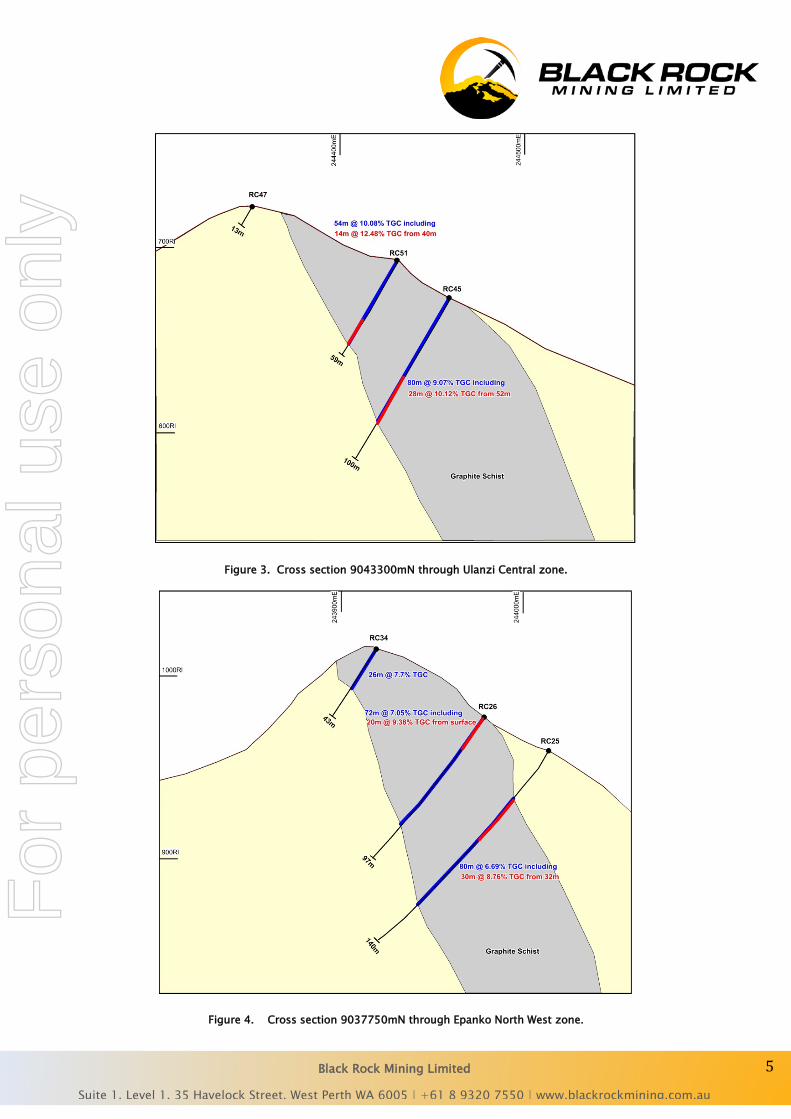
Figure 3. Cross section 9043300mN through Ulanzi Central zone.
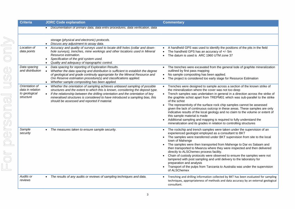
Figure 4. Cross section 9037750mN through Epanko North West zone.
For
per
sona
l use
onl
y

Black Rock Mining Limited
Suite 1, Level 1, 35 Havelock Street, West Perth WA 6005 | +61 8 9320 7550 | www.blackrockmining.com.au
6
Summary
• The updated Mahenge Exploration Target range of 84-115 million tonnes utilises the considerable amount of trench, pit and drill hole data that the Mahenge exploration team has generated this year.
• Of particular note is that Ulanzi and Cascade contribute more than 70% of this Exploration Target range.
• The new aerial survey covers Ulanzi north and west, to generate a high-resolution contour map to be used for the Ulanzi resource estimation expected in December.
• Drilling is expected to resume at Ulanzi by the end of October.
“The revised Exploration Target of 84-115Mt provides perspective on the potential of the Company’s Mahenge project, with over 70% derived from the new Ulanzi and Cascade discoveries. With drilling to resume by the end of the month at Ulanzi and a field programme commencing at the new Bagamoyo graphite discovery, our exploration team will have significant news to report through to Christmas.” Commented Steve Tambanis, Managing Director.
Black Rock Mining looks forward to updating shareholders as the Ulanzi drill programme continues together with updates from our recently acquired Bagamoyo graphite project.
For further information please contact:
Mr. Steven Tambanis Mr Gabriel Chiappini
Managing Director, Melbourne Director, Perth
Office: +61 8 9320 7550 +61 8 9320 7550
Email: [email protected] [email protected]
About Black Rock Mining Limited
Black Rock Mining Limited is an Australian based company listed on the Australian Securities Exchange. The Company has graphite tenure in the Mahenge and Bagamoyo regions, Tanzania, a country which hosts world-class graphite mineralisation. Drilling of the Epanko north prospect was completed in August 2015 and drilling of two new graphite discoveries, the Ulanzi and Cascade prospects, is currently underway. The Company plans to announce a Mahenge JORC compliant resource by the end of 2015. The newly discovered Bagamoyo project in Tanzania hosts very coarse flake graphite and is being mapped and sampled in preparation for a drilling. The company is building a skill and knowledge base to become an explorer, developer and diversified holder of graphite resources. Shareholder value will be added by:
• identifying and securing graphite projects with economic potential • focussing on tenure that can be commercialised quickly by converting into JORC compliant resources; and • taking these resources into production
Our focus is on establishing a JORC resource from three advanced prospects at Mahenge, whilst further adding resource upside through exploration at both Mahenge and Bagamoyo.
For
per
sona
l use
onl
y

Black Rock Mining Limited
Suite 1, Level 1, 35 Havelock Street, West Perth WA 6005 | +61 8 9320 7550 | www.blackrockmining.com.au
7
Competent Person Statements The information in this report that relates to Exploration Results is based on information compiled by Steven Tambanis, who is a member of the AusIMM. He is an employee of Black Rock Mining Limited. Steven Tambanis has sufficient experience which is relevant to the style of mineralisation and type of deposit under consideration and to the activity which he is undertaking to qualify as a Competent Person as defined in the 2004 and 2012 Edition of the ‘Australasian Code for Reporting of Exploration Results, Mineral Resources and Ore Reserves’. Steven Tambanis consents to the inclusion in the report of the matters based on their information in the form and context in which it appears, including the exploration target assessment. The information in this report that relates to Exploration Results is based on information compiled by Brendan Cummins, who is a member of the Australian Institute of Geoscientists. He is a consultant to Black Rock Mining Limited. Brendan Cummins has sufficient experience which is relevant to the style of mineralisation and type of deposit under consideration and to the activity which he is undertaking to qualify as a Competent Person as defined in the 2004 and 2012 Edition of the ‘Australasian Code for Reporting of Exploration Results, Mineral Resources and Ore Reserves’. Brendan Cummins consents to the inclusion in the report of the matters based on their information in the form and context in which it appears, including the exploration target assessment.
Appendix 1: JORC tables attached
Photo 5. Creek outcrop showing flat lying graphite mineralised rock
For
per
sona
l use
onl
y

1
JORC Code, 2012 Edition – Table 1 report template Section 1 Sampling Techniques and Data (Criteria in this section apply to all succeeding sections.)
Criteria JORC Code explanation Commentary
Sampling techniques
• Nature and quality of sampling (eg cut channels, random chips, or specific specialised industry standard measurement tools appropriate to the minerals under investigation, such as down hole gamma sondes, or handheld XRF instruments, etc). These examples should not be taken as limiting the broad meaning of sampling.
• Include reference to measures taken to ensure sample representivity and the appropriate calibration of any measurement tools or systems used.
• Aspects of the determination of mineralisation that are Material to the Public Report.
• In cases where ‘industry standard’ work has been done this would be relatively simple (eg ‘reverse circulation drilling was used to obtain 1 m samples from which 3 kg was pulverised to produce a 30 g charge for fire assay’). In other cases more explanation may be required, such as where there is coarse gold that has inherent sampling problems. Unusual commodities or mineralisation types (eg submarine nodules) may warrant disclosure of detailed information.
• Rock chip samples taken from outcrop of from surface float thought to be derived from shallow buried cover within 15m radius
• Pit samples are excavated to in-situ basement rock where possible. If the pit did not reach basement and sampled cover/float/scree, then this is noted in the sample log.
• Trench samples were taken at 1-3m intervals along the floor of the trench • Trenches range in depth from 1.0m to 2.5 with an average depth of 1.8m.
Trenches have an average width of 1m • Surface rockchip and trench samples range between 0.5kg and 2.5kg in
weight • The Company has taken all care to ensure no material containing additional
carbon has contaminated the samples • All samples are individually labeled and logged • Drill sampling consisted of quarter core sampling of diamond core on a 2m
sample interval. RC samples were riffle split on an individual 1m interval then composited as two x 1m samples per sample submitted to the laboratory.
Drilling techniques
• Drill type (eg core, reverse circulation, open-hole hammer, rotary air blast, auger, Bangka, sonic, etc) and details (eg core diameter, triple or standard tube, depth of diamond tails, face-sampling bit or other type, whether core is oriented and if so, by what method, etc).
• Both diamond core (HQ double tube) and reverse circulation (5” face sampling) drilling methods have been used
Drill sample recovery
• Method of recording and assessing core and chip sample recoveries and results assessed.
• Measures taken to maximise sample recovery and ensure representative nature of the samples.
• Whether a relationship exists between sample recovery and grade and whether sample bias may have occurred due to preferential loss/gain of fine/coarse material.
• Drill sample recoveries have been measured for all holes and found to be good
Logging • Whether core and chip samples have been geologically and geotechnically logged to a level of detail to support appropriate Mineral Resource estimation, mining studies and metallurgical studies.
• Whether logging is qualitative or quantitative in nature. Core (or costean, channel, etc) photography.
• The total length and percentage of the relevant intersections logged. • Drill logging of diamond core and RC
• Surface rockchip samples were described in basic terms – lithology, degree of weathering, flake size and an estimate of grade
• Trench rockchip samples were described in basic terms – lithology, degree of weathering, flake size and an estimate of grade in 1m intervals
• All drill holes have been comprehensively logged for lithology, mineralisation,
recoveries, orientation, structure and RQD (core). All drill holes have been
For
per
sona
l use
onl
y

2
Criteria JORC Code explanation Commentary
photographed. Sawn diamond core has been retained for a record in core trays. RC
chips stored in both chip trays and 1-3kg individual metre samples as a record.
Sub-sampling techniques and sample preparation
• If core, whether cut or sawn and whether quarter, half or all core taken. • If non-core, whether riffled, tube sampled, rotary split, etc and whether
sampled wet or dry. • For all sample types, the nature, quality and appropriateness of the sample
preparation technique. • Quality control procedures adopted for all sub-sampling stages to maximise
representivity of samples. • Measures taken to ensure that the sampling is representative of the in situ
material collected, including for instance results for field duplicate/second-half sampling.
• Whether sample sizes are appropriate to the grain size of the material being sampled.
• The surface rockchip samples have not undergone any field splitting or composition • Trench samples were taken in 1m intervals with sampling techniques used to ensure
representivity of the target rocktype. • No splitting or compositing of the trench samples was undertaken • Diamond core samples were halved with one half then quartered. A quarter core
sample was taken for laboratory analysis. The remaining quarter core sample is retained for a record and a half core sample retained for metallurgical testwork.
• RC samples were collected for every down-hole metre in a separate RC bag. Each metre sample was split through a three-tier riffle splitter and a 1.5kg sample taken of each meter. Two one-metre samples, totaling 3kg in weight were composited for assay submission.
Quality of assay data and laboratory tests
• The nature, quality and appropriateness of the assaying and laboratory procedures used and whether the technique is considered partial or total.
• For geophysical tools, spectrometers, handheld XRF instruments, etc, the parameters used in determining the analysis including instrument make and model, reading times, calibrations factors applied and their derivation, etc.
• Nature of quality control procedures adopted (eg standards, blanks, duplicates, external laboratory checks) and whether acceptable levels of accuracy (ie lack of bias) and precision have been established.
• The samples were sent to Mwanza in Tanzania for preparation and pulps were then sent to Brisbane for TGC analysis for Total Graphitic Carbon (TGC) C-IR18 LECO Total Carbon.
• Graphitic C is determined by digesting sample in 50% HCl to evolve carbonate as CO2. Residue is filtered, washed, dried and then roasted at 425C. The roasted residue is analysed for carbon by high temperature Leco furnace with infra red detection. Method Precision: ± 15% Reporting Limit: 0.02 - 100ppm
• Some of the surface rockchip samples were analysed for Multi-elements using ME-ICP81 sodium peroxide fusion and dissolution with elements determined by ICP.
• Some of the surface rockchip samples were analysed for Multi-elements using ME-MS61 for 48 elements using a HF-HNO3-HClO4 acid digestion, HCl leach followed by ICP-AES and ICP-MS analysis.
• Some of the surface rockchip samples were analysed for Multi-elements using ME-MS81 using lithium borate fusion and ICP-MS determination for 38 elements.
• All analysis has been carried out by certified laboratory – ALSchemex. TGC is the most appropriate method to analyse for graphitic carbon and it is total analysis. ALSChemex inserted its own standards and blanks and completed its own QAQC for each batch of samples
• BKT inserted certified standard material at a rate of 5%. BKT inserted a field duplicate at a rate of 5%
• BKT is satisfied the TGC results are accurate and precise
Verification of sampling and assaying
• The verification of significant intersections by either independent or alternative company personnel.
• The use of twinned holes.
• The data has been manually updated into a master spreadsheet which is considered to be appropriate for this early stage in the exploration program
•
For
per
sona
l use
onl
y
3
Criteria JORC Code explanation Commentary • Documentation of primary data, data entry procedures, data verification, data
storage (physical and electronic) protocols. • Discuss any adjustment to assay data.
Location of data points
• Accuracy and quality of surveys used to locate drill holes (collar and down- hole surveys), trenches, mine workings and other locations used in Mineral Resource estimation.
• Specification of the grid system used. • Quality and adequacy of topographic control.
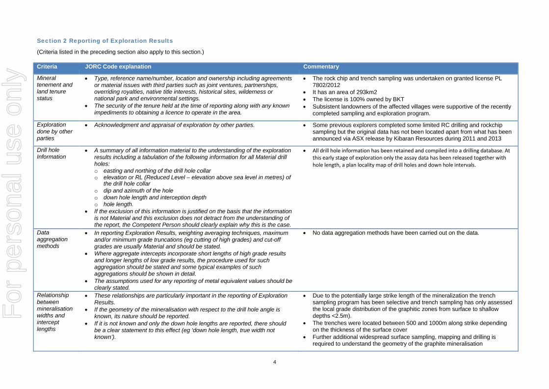
• A handheld GPS was used to identify the positions of the pits in the field • The handheld GPS has an accuracy of +/- 5m • The datum is used is ARC 1960 UTM zone 37
Data spacing and distribution
• Data spacing for reporting of Exploration Results. • Whether the data spacing and distribution is sufficient to establish the degree
of geological and grade continuity appropriate for the Mineral Resource and Ore Reserve estimation procedure(s) and classifications applied.
• Whether sample compositing has been applied.
• The trenches were excavated from the general lode of graphite mineralization outlined by first pass mapping
• No sample compositing has been applied. • The project is considered too early stage for Resource Estimation
Orientation of data in relation to geological structure
• Whether the orientation of sampling achieves unbiased sampling of possible structures and the extent to which this is known, considering the deposit type.
• If the relationship between the drilling orientation and the orientation of key mineralised structures is considered to have introduced a sampling bias, this should be assessed and reported if material.
• Trenches were designed to sample across a section of the known strike of the mineralization where the cover was not too deep
• Trench samples was undertaken in general in a direction across the strike of the graphite schist apart from TREPM01 which was sub-parallel to the strike of the schist
• The representivity of the surface rock chip samples cannot be assessed given the lack of continuous outcrop in these areas. These samples are only indicative results of the local geology and no claim to the volume or extent of this sample material is made
• Additional sampling and mapping is required to fully understand the mineralization and its grades in relation to controlling structures
Sample security
• The measures taken to ensure sample security. • The rockchip and trench samples were taken under the supervision of an experienced geologist employed as a consultant to BKT
• The samples were transferred under BKT supervision from site to the local town of Mahenge
• The samples were then transported from Mahenge to Dar es Salaam and then transported to Mwanza where they were inspected and then delivered directly to ALSChemex process facility.
• Chain of custody protocols were observed to ensure the samples were not tampered with post sampling and until delivery to the laboratory for preparation and analysis
• Transport of the pulps from Tanzania to Australia was under the supervision of ALSChemex
Audits or reviews
• The results of any audits or reviews of sampling techniques and data. • Trenching and drilling information collected by BKT has been evaluated for sampling techniques, appropriateness of methods and data accuracy by an external geological consultant.
For
per
sona
l use
onl
y
4
Section 2 Reporting of Exploration Results
(Criteria listed in the preceding section also apply to this section.)
Criteria JORC Code explanation Commentary
Mineral tenement and land tenure status
• Type, reference name/number, location and ownership including agreements or material issues with third parties such as joint ventures, partnerships, overriding royalties, native title interests, historical sites, wilderness or national park and environmental settings.
• The security of the tenure held at the time of reporting along with any known impediments to obtaining a licence to operate in the area.
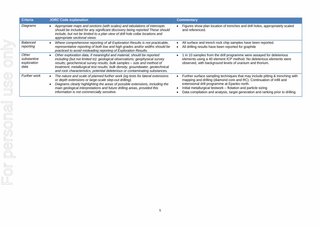
• The rock chip and trench sampling was undertaken on granted license PL 7802/2012
• It has an area of 293km2 • The license is 100% owned by BKT • Subsistent landowners of the affected villages were supportive of the recently
completed sampling and exploration program.
Exploration done by other parties
• Acknowledgment and appraisal of exploration by other parties. • Some previous explorers completed some limited RC drilling and rockchip sampling but the original data has not been located apart from what has been announced via ASX release by Kibaran Resources during 2011 and 2013
Drill hole Information
• A summary of all information material to the understanding of the exploration results including a tabulation of the following information for all Material drill holes: o easting and northing of the drill hole collar o elevation or RL (Reduced Level – elevation above sea level in metres) of
the drill hole collar o dip and azimuth of the hole o down hole length and interception depth o hole length.
• If the exclusion of this information is justified on the basis that the information is not Material and this exclusion does not detract from the understanding of the report, the Competent Person should clearly explain why this is the case.
• All drill hole information has been retained and compiled into a drilling database. At this early stage of exploration only the assay data has been released together with hole length, a plan locality map of drill holes and down hole intervals.
Data aggregation methods
• In reporting Exploration Results, weighting averaging techniques, maximum and/or minimum grade truncations (eg cutting of high grades) and cut-off grades are usually Material and should be stated.
• Where aggregate intercepts incorporate short lengths of high grade results and longer lengths of low grade results, the procedure used for such aggregation should be stated and some typical examples of such aggregations should be shown in detail.
• The assumptions used for any reporting of metal equivalent values should be clearly stated.
• No data aggregation methods have been carried out on the data.
Relationship between mineralisation widths and intercept lengths
• These relationships are particularly important in the reporting of Exploration Results.
• If the geometry of the mineralisation with respect to the drill hole angle is known, its nature should be reported.
• If it is not known and only the down hole lengths are reported, there should be a clear statement to this effect (eg ‘down hole length, true width not known’).
• Due to the potentially large strike length of the mineralization the trench sampling program has been selective and trench sampling has only assessed the local grade distribution of the graphitic zones from surface to shallow depths <2.5m).
• The trenches were located between 500 and 1000m along strike depending on the thickness of the surface cover
• Further additional widespread surface sampling, mapping and drilling is required to understand the geometry of the graphite mineralisation
For
per
sona
l use
onl
y
5
Criteria JORC Code explanation Commentary Diagrams • Appropriate maps and sections (with scales) and tabulations of intercepts
should be included for any significant discovery being reported These should include, but not be limited to a plan view of drill hole collar locations and appropriate sectional views.
• Figures show plan location of trenches and drill holes, appropriately scaled and referenced.
Balanced reporting
• Where comprehensive reporting of all Exploration Results is not practicable, representative reporting of both low and high grades and/or widths should be practiced to avoid misleading reporting of Exploration Results.
• All surface and trench rock chip samples have been reported. • All drilling results have been reported for graphite
Other substantive exploration data
• Other exploration data, if meaningful and material, should be reported including (but not limited to): geological observations; geophysical survey results; geochemical survey results; bulk samples – size and method of treatment; metallurgical test results; bulk density, groundwater, geotechnical and rock characteristics; potential deleterious or contaminating substances.
• 1 in 10 samples from the drill programme were assayed for deleterious elements using a 40 element ICP method. No deleterious elements were observed, with background levels of uranium and thorium.
Further work • The nature and scale of planned further work (eg tests for lateral extensions or depth extensions or large-scale step-out drilling).
• Diagrams clearly highlighting the areas of possible extensions, including the main geological interpretations and future drilling areas, provided this information is not commercially sensitive.
• Further surface sampling techniques that may include pitting & trenching with mapping and drilling (diamond core and RC). Continuation of infill and extensional drill programme at Epanko north.
• Initial metallurgical testwork – flotation and particle sizing • Data compilation and analysis, target generation and ranking prior to drilling.
For
per
sona
l use
onl
y
6
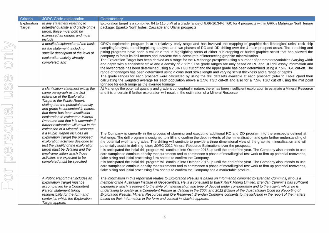
Criteria JORC Code explanation Commentary Exploration Target
In any statement referring to potential quantity and grade of the target, these must both be expressed as ranges and must include
Exploration target is a combined 84 to 115.5 Mt at a grade range of 8.66-10.34% TGC for 4 prospects within GRK’s Mahenge North tenure package: Epanko North lodes, Cascade and Ulanzi prospects
a detailed explanation of the basis for the statement, including specific description of the level of exploration activity already completed, and
GRK’s exploration program is at a relatively early stage and has involved the mapping of graphite-rich lithological units, rock chip sampling/analysis, trenching/pitting analysis and two phases of RC and DD drilling over the 4 main prospect areas. The trenching and pitting programs have been a valuable tool in highlighting areas of either sub-cropping or buried graphite schist that has allowed the company to focus its drill metres and increase the success rate of intersecting graphite mineralisation. The Exploration Target has been derived as a range for the 4 Mahenge prospects using a number of parameters/variables (varying width and depth with a consistent strike and a density of 2.6t/m³. The grade ranges are only based on RC and DD drill assay information and the lower grade has been determined using a 2.5% TGC cut off and the upper grade has been determined using a 7.5% TGC cut-off. The range of tonnages has been determined using a consistent strike length and varying schist thickness and a range of depths The grade ranges for each prospect were calculated by using the drill datasets available at each prospect (refer to Table 2)and then calculating the weighted average for each population above a 2.5% TGC cut-off and also for a 7.5% TGC cut off using the mid point tonnage for each range as the average tonnage
a clarification statement within the same paragraph as the first reference of the Exploration Target in the Public Report, stating that the potential quantity and grade is conceptual in nature, that there has been insufficient exploration to estimate a Mineral Resource and that it is uncertain if further exploration will result in the estimation of a Mineral Resource.
At Mahenge the potential quantity and grade is conceptual in nature, there has been insufficient exploration to estimate a Mineral Resource and it is uncertain if further exploration will result in the estimation of a Mineral Resource
If a Public Report includes an Exploration Target the proposed exploration activities designed to test the validity of the exploration target must be detailed and the timeframe within which those activities are expected to be completed must be specified
The Company is currently in the process of planning and executing additional RC and DD program into the prospects defined at Mahenge. The drill program is designed to infill and confirm the depth extents of the mineralisation and gain further understanding of the potential width and grades. The drilling will continue to provide a three dimensional view of the graphite mineralisation and will potentially assist in defining future JORC 2012 Mineral Resource Estimations over the prospects. It is anticipated the initial drill program will continue into October 2015 up until the end of the year. The Company also intends to use core samples to continue density measurements and to commence a phase of metallurgical test work to firm up potential recoveries, flake sizing and initial processing flow sheets to confirm the Company. It is anticipated the initial drill program will continue into October 2015 up until the end of the year. The Company also intends to use core samples to continue density measurements and to commence a phase of metallurgical test work to firm up potential recoveries, flake sizing and initial processing flow sheets to confirm the Company has a marketable product.
A Public Report that includes an Exploration Target must be accompanied by a Competent Person statement taking responsibility for the form and context in which the Exploration Target appears
The information in this report that relates to Exploration Results is based on information compiled by Brendan Cummins, who is a member of the Australian Institute of Geoscientists. He is a consultant to Black Rock Mining Limited. Brendan Cummins has sufficient experience which is relevant to the style of mineralisation and type of deposit under consideration and to the activity which he is undertaking to qualify as a Competent Person as defined in the 2004 and 2012 Edition of the ‘Australasian Code for Reporting of Exploration Results, Mineral Resources and Ore Reserves’. Brendan Cummins consents to the inclusion in the report of the matters based on their information in the form and context in which it appears.
For
per
sona
l use
onl
y

7
For an Exploration Target based on Exploration Results, a summary of the relevant exploration data available and the nature of the results should also be stated, including a disclosure of the current drill hole or sampling spacing and relevant plans or sections
Table 1 Surface Exploration activity summary
Exploration Activity Number of Activity
Trench Samples
Pit Samples
Mahenge North total rock chip sampling
66 - -
Epanko North: West zone
435
Epanko North: Middle zone
132
Cascade 1 437 168 Ulanzi 24 483
Table 2 Drill statistics by each prospect from Mahenge North prospect
Drilling activities Type of Activity
Holes Metres drilled
Average depth
Epanko North: West zone
RC 36 3262 88 DD 9 1219.3 135.5
Epanko North: Middle zone
RC 4 158 40 DD 3 194.06 64.69
Cascade RC 4 399 100 DD
Ulanzi RC 16 1106 69 DD 3 360.94 120.31
Total 75holes 6700m Ave 88m • Drill spacing at Epanko North West zone has been completed on a 50 x50m grid extending over 800m of strike with the remaining
strike restricted to isolated drill positions every few hundred metres depending on access • Drill spacing at Epanko North East zone has been restricted to areas of access and has not had any systematic drilling • Drill spacing at Cascade has been restricted to areas of access and has not had any systematic drilling. The strike extent covered
by drilling is 300m • Drill spacing at Ulanzi has been completed on a 100x50m grid extending over 1000m of strike
For
per
sona
l use
onl
y