Biomes, Food Webs, & Interactions- Oh, MY! ECOLOGY & EVOLUTION PROJECT- 50 POINTS!!

Farmers planting rice in paddy � elds near Chiangmai, Thailand
TOPIC 1 SUSTAINABLE BIOMES
CHAPTER 3
Biomes produce food
3.1 Overview 3.1.1 Introduction Food dominates every person’s life. For many people, what to have for breakfast, lunch and dinner can be a constant thought and sometimes a worry. Food is an essential need for every human as it provides the essential nutrients for the body to sustain and maintain a healthy life. Biomes are key to producing the world's food.
Starter questions1 Why do you think people around the world eat different kinds of food? 2 Do you think there is enough food in the world for everybody? Why? How do
you know? 3 a Is there enough space for your family to grow fruit and vegetables in your
home garden, if you had to? b Does your family have a garden and, if so, does your family grow its own
food? c Conduct a class discussion to establish to what extent people in your
class grow food at home.
Inquiry sequence Syllabus outcomes
3.1 Overview
3.2 How can we feed the world? GE5-3
3.3 What does the world eat? GE5-3
3.4 SkillBuilder: Constructing ternary graphs
GE5-3 GE5-7
3.5 How does traditional agriculture produce food?
GE5-3 GE5-5
3.6 How have we increased our food? GE5-2 GE5-3
3.7 How is food produced in Australia? GE5-2 GE5-3
3.8 Investigating topographic maps: What is a farming area like in Riverina?
GE5-2 GE5-3
3.9 SkillBuilder: Describing patterns and correlations on a topographic map
GE5-3 GE5-7
3.10 Why is rice an important food crop? GE5-2 GE5-3
3.11 Why is cacao a special food crop?
GE5-2 GE5-3
3.12 Daly River: a sustainable ecosystem?
GE5-2 GE5-3
3.13 Review GE5-2, GE5-3, GE5-5, GE5-7
Key terms
ONLINE ONLY
ONLINE ONLY
ONLINE ONLY
ONLINE ONLY
ONLINE ONLY
ONLINE ONLY
c03BiomesProduceFood.indd 46 19/10/16 8:07 am
UNCORRECTED Does your family have a garden and, if so, does your family grow its own
UNCORRECTED Does your family have a garden and, if so, does your family grow its own
Conduct a class discussion to establish to what extent people in your
UNCORRECTED Conduct a class discussion to establish to what extent people in your
UNCORRECTED
UNCORRECTED
UNCORRECTED
UNCORRECTED
UNCORRECTED
UNCORRECTED
UNCORRECTED
UNCORRECTED
UNCORRECTED
UNCORRECTED
UNCORRECTED
UNCORRECTED
UNCORRECTED
UNCORRECTED
UNCORRECTED
UNCORRECTED
UNCORRECTED
UNCORRECTED
UNCORRECTED
UNCORRECTED
UNCORRECTED
UNCORRECTED
UNCORRECTED
UNCORRECTED
UNCORRECTED
UNCORRECTED
UNCORRECTED
UNCORRECTED
UNCORRECTED
UNCORRECTED
UNCORRECTED
UNCORRECTED
UNCORRECTED
UNCORRECTED
UNCORRECTED
UNCORRECTED
UNCORRECTED
UNCORRECTED
UNCORRECTED
UNCORRECTED
UNCORRECTED
UNCORRECTED
UNCORRECTED
UNCORRECTED
UNCORRECTED
UNCORRECTED
UNCORRECTED
UNCORRECTED
UNCORRECTED
UNCORRECTED
UNCORRECTED
UNCORRECTED
UNCORRECTED
UNCORRECTED
UNCORRECTED
UNCORRECTED
UNCORRECTED
UNCORRECTED
UNCORRECTED
UNCORRECTED
UNCORRECTED
UNCORRECTED
UNCORRECTED
UNCORRECTED
UNCORRECTED
UNCORRECTED
UNCORRECTED
UNCORRECTED
UNCORRECTED
UNCORRECTED
UNCORRECTED
UNCORRECTED
UNCORRECTED
UNCORRECTED
UNCORRECTED
UNCORRECTED
UNCORRECTED
UNCORRECTED
UNCORRECTED
UNCORRECTED
UNCORRECTED
UNCORRECTED
UNCORRECTED
UNCORRECTED
UNCORRECTED
UNCORRECTED
UNCORRECTED
UNCORRECTED
UNCORRECTED
UNCORRECTED
UNCORRECTED
UNCORRECTED
UNCORRECTED
UNCORRECTED
UNCORRECTED
UNCORRECTED
UNCORRECTED
UNCORRECTED
UNCORRECTED
UNCORRECTED
UNCORRECTED
UNCORRECTED
UNCORRECTED
UNCORRECTED
UNCORRECTED
UNCORRECTED
UNCORRECTED
UNCORRECTED
UNCORRECTED
UNCORRECTED
UNCORRECTED
UNCORRECTED
UNCORRECTED
UNCORRECTED
UNCORRECTED
UNCORRECTED
UNCORRECTED
UNCORRECTED
UNCORRECTED
UNCORRECTED
UNCORRECTED
UNCORRECTED
UNCORRECTED
UNCORRECTED
UNCORRECTED
UNCORRECTED
UNCORRECTED
UNCORRECTED
UNCORRECTED
UNCORRECTED
UNCORRECTED
UNCORRECTED
UNCORRECTED
UNCORRECTED
UNCORRECTED
UNCORRECTED
UNCORRECTED
UNCORRECTED
UNCORRECTED
UNCORRECTED
UNCORRECTED
UNCORRECTED
UNCORRECTED
UNCORRECTED
UNCORRECTED
UNCORRECTED
UNCORRECTED
UNCORRECTED
UNCORRECTED
UNCORRECTED
UNCORRECTED
UNCORRECTED
UNCORRECTED
UNCORRECTED
UNCORRECTED
UNCORRECTED
UNCORRECTED
UNCORRECTED
UNCORRECTED
UNCORRECTED
UNCORRECTED
UNCORRECTED
UNCORRECTED
UNCORRECTED
UNCORRECTED
UNCORRECTED
UNCORRECTED
UNCORRECTED
UNCORRECTED
UNCORRECTED
UNCORRECTED
UNCORRECTED
UNCORRECTED
UNCORRECTED
UNCORRECTED
UNCORRECTED
UNCORRECTED
UNCORRECTED
UNCORRECTED
UNCORRECTED
UNCORRECTED
UNCORRECTED
UNCORRECTED
UNCORRECTED
UNCORRECTED
UNCORRECTED
UNCORRECTED
UNCORRECTED
UNCORRECTED
UNCORRECTED
UNCORRECTED
UNCORRECTED
UNCORRECTED
UNCORRECTED
UNCORRECTED
UNCORRECTED
UNCORRECTED
UNCORRECTED
UNCORRECTED
UNCORRECTED
UNCORRECTED
UNCORRECTED
UNCORRECTED
UNCORRECTED
UNCORRECTED
UNCORRECTED
UNCORRECTED
UNCORRECTED
UNCORRECTED
UNCORRECTED
UNCORRECTED
UNCORRECTED
UNCORRECTED
UNCORRECTED
UNCORRECTED
UNCORRECTED
UNCORRECTED
UNCORRECTED
UNCORRECTED
UNCORRECTED
UNCORRECTED
UNCORRECTED
UNCORRECTED
UNCORRECTED
UNCORRECTED
UNCORRECTED
UNCORRECTED
UNCORRECTED
UNCORRECTED
UNCORRECTED
UNCORRECTED
UNCORRECTED
UNCORRECTED
UNCORRECTED
UNCORRECTED
UNCORRECTED
UNCORRECTED
UNCORRECTED
UNCORRECTED
UNCORRECTED
UNCORRECTED
UNCORRECTED
UNCORRECTED
UNCORRECTED
UNCORRECTED
UNCORRECTED
UNCORRECTED
UNCORRECTED
UNCORRECTED
UNCORRECTED
UNCORRECTED
UNCORRECTED
UNCORRECTED
UNCORRECTED
UNCORRECTED
UNCORRECTED
UNCORRECTED
UNCORRECTED
UNCORRECTED
UNCORRECTED
UNCORRECTED
UNCORRECTED
UNCORRECTED
UNCORRECTED
UNCORRECTED
UNCORRECTED
UNCORRECTED
UNCORRECTED
UNCORRECTED
UNCORRECTED
UNCORRECTED
UNCORRECTED
UNCORRECTED
UNCORRECTED
UNCORRECTED
UNCORRECTED
UNCORRECTED
UNCORRECTED
UNCORRECTED
UNCORRECTED
UNCORRECTED
UNCORRECTED
UNCORRECTED
UNCORRECTED
UNCORRECTED
UNCORRECTED
UNCORRECTED
UNCORRECTED
UNCORRECTED
UNCORRECTED
UNCORRECTED
UNCORRECTED
UNCORRECTED
UNCORRECTED
UNCORRECTED
UNCORRECTED
UNCORRECTED
UNCORRECTED
UNCORRECTED
UNCORRECTED
UNCORRECTED
UNCORRECTED
UNCORRECTED
UNCORRECTED
UNCORRECTED
UNCORRECTED
UNCORRECTED
UNCORRECTED
UNCORRECTED
UNCORRECTED
UNCORRECTED
UNCORRECTED
UNCORRECTED
UNCORRECTED
UNCORRECTED
UNCORRECTED
UNCORRECTED
UNCORRECTED
UNCORRECTED
UNCORRECTED
UNCORRECTED
UNCORRECTED
UNCORRECTED
UNCORRECTED
UNCORRECTED
UNCORRECTED
UNCORRECTED
UNCORRECTED
UNCORRECTED
UNCORRECTED
UNCORRECTED
UNCORRECTED
UNCORRECTED
UNCORRECTED
UNCORRECTED
UNCORRECTED
UNCORRECTED
UNCORRECTED
UNCORRECTED
UNCORRECTED
UNCORRECTED
UNCORRECTED
UNCORRECTED
UNCORRECTED
UNCORRECTED
UNCORRECTED
UNCORRECTED
UNCORRECTED
UNCORRECTED
UNCORRECTED
UNCORRECTED
UNCORRECTED
UNCORRECTED
UNCORRECTED
UNCORRECTED
UNCORRECTED
UNCORRECTED
UNCORRECTED
UNCORRECTED
UNCORRECTED
UNCORRECTED
UNCORRECTED
UNCORRECTED
UNCORRECTED
UNCORRECTED
UNCORRECTED
UNCORRECTED
UNCORRECTED
UNCORRECTED
UNCORRECTED
UNCORRECTED
UNCORRECTED
UNCORRECTED
UNCORRECTED
UNCORRECTED
UNCORRECTED
UNCORRECTED
UNCORRECTED
UNCORRECTED
UNCORRECTED
UNCORRECTED
UNCORRECTED
UNCORRECTED
UNCORRECTED
UNCORRECTED
UNCORRECTED Syllabus outcomes
UNCORRECTED Syllabus outcomes
GE5-3
UNCORRECTED
GE5-3
GE5-3
UNCORRECTED
GE5-3
GE5-3
UNCORRECTED
GE5-3 GE5-7
UNCORRECTED
GE5-7
How have we increased our food?
UNCORRECTED
How have we increased our food?
How is food produced in Australia?
UNCORRECTED
How is food produced in Australia?
Investigating topographic maps:
UNCORRECTED
Investigating topographic maps:What is a farming area like in Riverina? UNCORRECTED
What is a farming area like in Riverina?
SkillBuilder:UNCORRECTED
SkillBuilder: Describing patterns UNCORRECTED
Describing patterns and correlations on a topographic map UNCORRECTED
and correlations on a topographic map UNCORRECTED
UNCORRECTED
UNCORRECTED
UNCORRECTED
UNCORRECTED
UNCORRECTED
UNCORRECTED
UNCORRECTED
UNCORRECTED
ONLINE
UNCORRECTED
ONLINEONLINE
UNCORRECTED
ONLINE ON
UNCORRECTED
ONON
UNCORRECTED
ONLY
UNCORRECTED
LYLY
UNCORRECTED
LY
PAGE
PAGE
PAGE there enough space for your family to grow fruit and vegetables in your
PAGE there enough space for your family to grow fruit and vegetables in your
Does your family have a garden and, if so, does your family grow its own PAGE Does your family have a garden and, if so, does your family grow its own
PROOFS

Watch this videoA plate full of biomesSearchlight ID: eles-1718
c03BiomesProduceFood.indd 47 19/10/16 8:07 am
UNCORRECTED PAGE P
ROOFS

48 Geoactive 2 NSW for the Australian Curriculum Stage 5
3.2 How can we feed the world? 3.2.1 Food production During the nineteenth century, Thomas Malthus was concerned that the population was growing faster than they could produce food, so he predicted a catastrophe. However, technological advances and the Green Revolution allowed humans to produce more food on a larger scale through monoculture to feed the growing population. With the Earth’s population projected to rise to nine billion people by 2050, what needs to be done to sustainably ensure there is enough food for everyone?
3.2.2 What are the spatial issues with our food? � e map in � gure 1 shows the space that is used for agriculture around the world. With continued population growth, the availability of arable land is of a concern. For instance, there is currently about one-sixth of a hectare of arable land per capita in East and South Asia. � e population of these regions is expected to experience rapid growth, but very little additional land is available for agricultural expansion. Consequently, arable land per capita will continue to decline in these areas with a potential food crisis.
3.2.3 Food production increases Agricultural yields vary widely around the world owing to climate, management practices and the types of crops grown. Globally, 15 million square kilometres of land are used for growing crops — alto-gether, that’s about the size of South America. Approximately 32 million square kilometres of land around the world are used for pasture — an area about the size of Africa. Across the Earth, most land that is suitable for agriculture is already used for that purpose and, in the last 50 years, we have increased our food production.
Green Revolution a signi� cant increase in agricultural productivity resulting from the introduction of high-yield varieties of grains, the use of pesticides and improved management
monoculture the cultivation of a single crop on a farm or in a region or country
arable describes land that can be used for growing crops
yields amount of agriculture produced or provided
Arctic Circle
Tropic of Cancer
Equator
Tropic of Capricorn
PACIFIC OCEAN
ARCTIC OCEAN
ATLANTIC
OCEAN
INDIAN
OCEAN
100% pasture100% cropland
None
Far from minimum Close to maximum
Type of agriculture
Yield of maize farmland20000 4000 km
Source: Spatial Vision
FIGURE 1 World distribution of cropland, pasture and maize. More maize, for example, could be grown if improvements were made to seeds, irrigation, fertiliser and markets.
c03BiomesProduceFood.indd 48 19/10/16 8:07 am
UNCORRECTED
UNCORRECTED
UNCORRECTED
UNCORRECTED
UNCORRECTED
UNCORRECTED
UNCORRECTED
UNCORRECTED
UNCORRECTED
UNCORRECTED
UNCORRECTED
UNCORRECTED
UNCORRECTED
UNCORRECTED
UNCORRECTED
UNCORRECTED
UNCORRECTED
UNCORRECTED
UNCORRECTED
UNCORRECTED
UNCORRECTED
UNCORRECTED
UNCORRECTED
UNCORRECTED
UNCORRECTED
UNCORRECTED
UNCORRECTED
UNCORRECTED
UNCORRECTED
UNCORRECTED
UNCORRECTED
UNCORRECTED
UNCORRECTED
UNCORRECTED
UNCORRECTED
UNCORRECTED
UNCORRECTED
UNCORRECTED
UNCORRECTED
UNCORRECTED
UNCORRECTED
UNCORRECTED
UNCORRECTED
UNCORRECTED
UNCORRECTED
UNCORRECTED
UNCORRECTED
UNCORRECTED
UNCORRECTED
UNCORRECTED
UNCORRECTED
UNCORRECTED
UNCORRECTED
UNCORRECTED
UNCORRECTED
UNCORRECTED
UNCORRECTED
UNCORRECTED
UNCORRECTED
UNCORRECTED
UNCORRECTED
UNCORRECTED
UNCORRECTED
UNCORRECTED
UNCORRECTED
UNCORRECTED
UNCORRECTED
UNCORRECTED
UNCORRECTED
UNCORRECTED
UNCORRECTED
UNCORRECTED
UNCORRECTED
UNCORRECTED
UNCORRECTED
UNCORRECTED
UNCORRECTED
UNCORRECTED
UNCORRECTED
UNCORRECTED
UNCORRECTED
UNCORRECTED
UNCORRECTED
UNCORRECTED
UNCORRECTED
UNCORRECTED
UNCORRECTED
UNCORRECTED
UNCORRECTED
UNCORRECTED
UNCORRECTED
UNCORRECTED
UNCORRECTED
UNCORRECTED
UNCORRECTED
UNCORRECTED
UNCORRECTED
UNCORRECTED
UNCORRECTED
UNCORRECTED
UNCORRECTED
UNCORRECTED
UNCORRECTED
UNCORRECTED
UNCORRECTED
UNCORRECTED
UNCORRECTED
UNCORRECTED
UNCORRECTED
UNCORRECTED
UNCORRECTED
UNCORRECTED
UNCORRECTED
UNCORRECTED
UNCORRECTED
UNCORRECTED
UNCORRECTED
UNCORRECTED
UNCORRECTED
UNCORRECTED
UNCORRECTED
UNCORRECTED
UNCORRECTED
UNCORRECTED
UNCORRECTED
UNCORRECTED
UNCORRECTED
UNCORRECTED
UNCORRECTED
UNCORRECTED
UNCORRECTED
UNCORRECTED
UNCORRECTED
UNCORRECTED
UNCORRECTED
UNCORRECTED
UNCORRECTED
UNCORRECTED
UNCORRECTED
UNCORRECTED
UNCORRECTED
UNCORRECTED
UNCORRECTED
UNCORRECTED
UNCORRECTED
UNCORRECTED
UNCORRECTED
UNCORRECTED
UNCORRECTED
UNCORRECTED
UNCORRECTED
UNCORRECTED
UNCORRECTED
UNCORRECTED
UNCORRECTED
UNCORRECTED
UNCORRECTED
UNCORRECTED
UNCORRECTED
UNCORRECTED
UNCORRECTED
UNCORRECTED
UNCORRECTED
UNCORRECTED
UNCORRECTED
UNCORRECTED
UNCORRECTED
UNCORRECTED
UNCORRECTED
UNCORRECTED
UNCORRECTED
UNCORRECTED
UNCORRECTED
UNCORRECTED
UNCORRECTED
UNCORRECTED
UNCORRECTED
UNCORRECTED
UNCORRECTED
UNCORRECTED
UNCORRECTED
UNCORRECTED
UNCORRECTED
UNCORRECTED
UNCORRECTED
UNCORRECTED
UNCORRECTED
UNCORRECTED
UNCORRECTED
UNCORRECTED
UNCORRECTED
UNCORRECTED
UNCORRECTED
UNCORRECTED
UNCORRECTED
UNCORRECTED
UNCORRECTED
UNCORRECTED
UNCORRECTED
UNCORRECTED
UNCORRECTED
UNCORRECTED
UNCORRECTED
UNCORRECTED
UNCORRECTED
UNCORRECTED
UNCORRECTED
UNCORRECTED
UNCORRECTED
UNCORRECTED
UNCORRECTED
UNCORRECTED
UNCORRECTED
UNCORRECTED
UNCORRECTED
UNCORRECTED
UNCORRECTED
UNCORRECTED
UNCORRECTED
UNCORRECTED
UNCORRECTED
UNCORRECTED
UNCORRECTED
UNCORRECTED
UNCORRECTED
UNCORRECTED
UNCORRECTED
UNCORRECTED
UNCORRECTED
UNCORRECTED
UNCORRECTED
UNCORRECTED
UNCORRECTED
UNCORRECTED
UNCORRECTED
UNCORRECTED
UNCORRECTED
UNCORRECTED
UNCORRECTED
UNCORRECTED
UNCORRECTED
UNCORRECTED
UNCORRECTED
UNCORRECTED
UNCORRECTED
UNCORRECTED
UNCORRECTED
UNCORRECTED
UNCORRECTED
UNCORRECTED
UNCORRECTED
UNCORRECTED
UNCORRECTED
UNCORRECTED
UNCORRECTED
UNCORRECTED
UNCORRECTED
UNCORRECTED
UNCORRECTED
UNCORRECTED
UNCORRECTED
UNCORRECTED
UNCORRECTED
UNCORRECTED
UNCORRECTED
UNCORRECTED
UNCORRECTED
UNCORRECTED
UNCORRECTED
UNCORRECTED
UNCORRECTED
UNCORRECTED
UNCORRECTED
UNCORRECTED
UNCORRECTED
UNCORRECTED
UNCORRECTED
UNCORRECTED
UNCORRECTED
UNCORRECTED
UNCORRECTED
UNCORRECTED
UNCORRECTED
UNCORRECTED
UNCORRECTED
UNCORRECTED
UNCORRECTED
UNCORRECTED
UNCORRECTED
UNCORRECTED
UNCORRECTED
UNCORRECTED
UNCORRECTED
UNCORRECTED
UNCORRECTED
UNCORRECTED
UNCORRECTED
UNCORRECTED
UNCORRECTED
UNCORRECTED
UNCORRECTED
UNCORRECTED
UNCORRECTED
UNCORRECTED
UNCORRECTED
UNCORRECTED
UNCORRECTED
UNCORRECTED
UNCORRECTED
UNCORRECTED
UNCORRECTED
UNCORRECTED
UNCORRECTED
UNCORRECTED
UNCORRECTED
UNCORRECTED
UNCORRECTED
UNCORRECTED
UNCORRECTED
UNCORRECTED
UNCORRECTED
UNCORRECTED
UNCORRECTED
UNCORRECTED
UNCORRECTED
UNCORRECTED
UNCORRECTED
UNCORRECTED
UNCORRECTED
UNCORRECTED
UNCORRECTED
UNCORRECTED
UNCORRECTED
UNCORRECTED
UNCORRECTED
UNCORRECTED
UNCORRECTED
UNCORRECTED
UNCORRECTED
UNCORRECTED
UNCORRECTED
UNCORRECTED
UNCORRECTED
UNCORRECTED
UNCORRECTED
UNCORRECTED
UNCORRECTED
UNCORRECTED
UNCORRECTED
UNCORRECTED
UNCORRECTED
UNCORRECTED
UNCORRECTED
UNCORRECTED
UNCORRECTED
UNCORRECTED
UNCORRECTED
UNCORRECTED
UNCORRECTED
UNCORRECTED
UNCORRECTED
UNCORRECTED
UNCORRECTED
UNCORRECTED
UNCORRECTED
UNCORRECTED
UNCORRECTED
UNCORRECTED
UNCORRECTED
UNCORRECTED
UNCORRECTED
UNCORRECTED
UNCORRECTED
UNCORRECTED
UNCORRECTED
UNCORRECTED
UNCORRECTED
UNCORRECTED
UNCORRECTED
UNCORRECTED
UNCORRECTED
UNCORRECTED
UNCORRECTED
UNCORRECTED
UNCORRECTED
UNCORRECTED
UNCORRECTED
UNCORRECTED
UNCORRECTED
UNCORRECTED
UNCORRECTED
UNCORRECTED
UNCORRECTED
UNCORRECTED
UNCORRECTED
UNCORRECTED
UNCORRECTED
UNCORRECTED
UNCORRECTED
UNCORRECTED
UNCORRECTED
UNCORRECTED
UNCORRECTED
UNCORRECTED
UNCORRECTED
UNCORRECTED
UNCORRECTED
UNCORRECTED
UNCORRECTED
UNCORRECTED
UNCORRECTED
UNCORRECTED
UNCORRECTED
UNCORRECTED
UNCORRECTED
UNCORRECTED
UNCORRECTED
UNCORRECTED
UNCORRECTED
UNCORRECTED
UNCORRECTED
UNCORRECTED
UNCORRECTED
UNCORRECTED
UNCORRECTED
UNCORRECTED
UNCORRECTED
UNCORRECTED
UNCORRECTED
UNCORRECTED
UNCORRECTED
UNCORRECTED
UNCORRECTED
UNCORRECTED
UNCORRECTED
UNCORRECTED
UNCORRECTED
UNCORRECTED
UNCORRECTED
UNCORRECTED
UNCORRECTED
UNCORRECTED
UNCORRECTED
UNCORRECTED
UNCORRECTED
UNCORRECTED
UNCORRECTED
UNCORRECTED
UNCORRECTED
UNCORRECTED
UNCORRECTED
UNCORRECTED
UNCORRECTED
UNCORRECTED
UNCORRECTED
UNCORRECTED
UNCORRECTED
UNCORRECTED
UNCORRECTED
UNCORRECTED
UNCORRECTED
UNCORRECTED
UNCORRECTED
UNCORRECTED
UNCORRECTED
UNCORRECTED
UNCORRECTED
UNCORRECTED
UNCORRECTED
UNCORRECTED
UNCORRECTED
UNCORRECTED
UNCORRECTED
UNCORRECTED
UNCORRECTED
UNCORRECTED
UNCORRECTED
UNCORRECTED
UNCORRECTED
UNCORRECTED
UNCORRECTED
UNCORRECTED
UNCORRECTED
UNCORRECTED
UNCORRECTED
UNCORRECTED
UNCORRECTED
UNCORRECTED
UNCORRECTED
UNCORRECTED
UNCORRECTED
UNCORRECTED
UNCORRECTED
UNCORRECTED
UNCORRECTED
UNCORRECTED
UNCORRECTED
UNCORRECTED
UNCORRECTED
UNCORRECTED
UNCORRECTED
UNCORRECTED
UNCORRECTED
UNCORRECTED
UNCORRECTED
UNCORRECTED
UNCORRECTED
UNCORRECTED
UNCORRECTED
UNCORRECTED
UNCORRECTED
UNCORRECTED
UNCORRECTED
UNCORRECTED
UNCORRECTED
UNCORRECTED
UNCORRECTED
UNCORRECTED
UNCORRECTED
UNCORRECTED
UNCORRECTED
UNCORRECTED
UNCORRECTED
UNCORRECTED
UNCORRECTED
UNCORRECTED
UNCORRECTED
UNCORRECTED
UNCORRECTED
UNCORRECTED
UNCORRECTED
UNCORRECTED
UNCORRECTED
UNCORRECTED
UNCORRECTED
UNCORRECTED
UNCORRECTED
UNCORRECTED
UNCORRECTED
UNCORRECTED
UNCORRECTED
UNCORRECTED
UNCORRECTED
UNCORRECTED
UNCORRECTED
UNCORRECTED
UNCORRECTED
UNCORRECTED
UNCORRECTED
UNCORRECTED
UNCORRECTED
UNCORRECTED
UNCORRECTED
UNCORRECTED
UNCORRECTED
UNCORRECTED
UNCORRECTED
UNCORRECTED
UNCORRECTED
UNCORRECTED
UNCORRECTED
UNCORRECTED
UNCORRECTED
UNCORRECTED
UNCORRECTED
UNCORRECTED
UNCORRECTED
UNCORRECTED
UNCORRECTED
UNCORRECTED
UNCORRECTED
UNCORRECTED
UNCORRECTED
UNCORRECTED
UNCORRECTED
UNCORRECTED
UNCORRECTED
UNCORRECTED
UNCORRECTED
UNCORRECTED
UNCORRECTED
UNCORRECTED
UNCORRECTED
INDIAN
UNCORRECTED
INDIAN
UNCORRECTED
UNCORRECTED
UNCORRECTED
UNCORRECTED
UNCORRECTED
UNCORRECTED
UNCORRECTED
UNCORRECTED
UNCORRECTED
UNCORRECTED
UNCORRECTED
UNCORRECTED
UNCORRECTED
UNCORRECTED
UNCORRECTED
UNCORRECTED
UNCORRECTED
UNCORRECTED
UNCORRECTED
UNCORRECTED
UNCORRECTED
UNCORRECTED
UNCORRECTED
UNCORRECTED
UNCORRECTED
UNCORRECTED
UNCORRECTED
UNCORRECTED
UNCORRECTED
UNCORRECTED
UNCORRECTED
UNCORRECTED
UNCORRECTED
UNCORRECTED
UNCORRECTED
UNCORRECTED
UNCORRECTED
UNCORRECTED
UNCORRECTED
UNCORRECTED
UNCORRECTED
UNCORRECTED
UNCORRECTED
UNCORRECTED
UNCORRECTED
UNCORRECTED
UNCORRECTED
UNCORRECTED
UNCORRECTED
UNCORRECTED
UNCORRECTED
UNCORRECTED
UNCORRECTED
UNCORRECTED
UNCORRECTED
UNCORRECTED
UNCORRECTED
UNCORRECTED
UNCORRECTED
UNCORRECTED
UNCORRECTED
UNCORRECTED
UNCORRECTED
UNCORRECTED
UNCORRECTED
UNCORRECTED
UNCORRECTED PAGE
PAGE
PAGE
PAGE
PAGE
PAGE
PAGE
PAGE
PAGE
PAGE
PAGE
PAGE
PAGE
PAGE
PAGE
PAGE
PAGE
PAGE
PAGE
PAGE
PAGE
PAGE
PAGE
PAGE
PAGE ARCTIC OCEAN
PAGE ARCTIC OCEANARCTIC OCEAN
PAGE ARCTIC OCEAN
PAGE World distribution of cropland, pasture and maize. More maize, for example, could be grown if improvements were
PAGE World distribution of cropland, pasture and maize. More maize, for example, could be grown if improvements were PROOFS
� e map in � gure 1 shows the space that is used for agriculture around the world. With continued
PROOFS � e map in � gure 1 shows the space that is used for agriculture around the world. With continued population growth, the availability of arable land is of a concern. For instance, there is currently
PROOFSpopulation growth, the availability of arable land is of a concern. For instance, there is currently
land per capita in East and South Asia. � e population of
PROOFS land per capita in East and South Asia. � e population of
these regions is expected to experience rapid growth, but very little additional land is available for
PROOFSthese regions is expected to experience rapid growth, but very little additional land is available for agricultural expansion. Consequently, arable land per capita will continue to decline in these areas
PROOFSagricultural expansion. Consequently, arable land per capita will continue to decline in these areas

Chapter 3 Biomes produce food 49
Current FAO projections suggest that cereal demand will increase by almost 50 per cent by 2050 (see �gure 2). To meet this demand, either current land will need to increase yields per unit of area, croplands will need to expand by replacing natural habitats, or farmers will need to grow crops more e�ciently.
�e recent increase in food production has been a result of innovations in agriculture. Crop yields have been boosted through advanced seed genetics; agronomy practices (scienti�c production of food plants), and product innova-tions that help farmers maximize productivity and quality. In this way, the nutritional content of crops can be increased (see �gure 3).
We could do moreIt should be possible to get more food out of the land we are already using. Figure 1 shows the places where maize yields could increase and become more sustainable by improving nutrient and water management, seed types and markets.
FAO Food and Agricultural Organization of the United Nations
innovations new and original improvement to something, such as a piece of technology or a variety of plant or seed
sustainable describes the use by people of the Earth’s environmental resources at a rate such that the capacity for renewal is ensured
FIGURE 3 Farmers in a village in Kenya examine information on plant diseases using a laptop at a plant health clinic. They can also consult a plant pathologist and show them samples of their crops.
FIGURE 2 Crop yields in developing countries 1961 to 2030
1961–63
1997–99
2030
Yie
ld (t
onn
e/ha
)
0
1
2
3
4
5
Rice Maize Wheat Soy-bean
Seed-cotton
Ground-nut
Sorghum Millet Pulses
c03BiomesProduceFood.indd 49 19/10/16 8:07 am
UNCORRECTED PAGE by improving nutrient and water
PAGE by improving nutrient and water
PAGE
PAGE Farmers in a village in Kenya examine information on plant diseases using a laptop at a plant
PAGE Farmers in a village in Kenya examine information on plant diseases using a laptop at a plant
health clinic. They can also consult a plant pathologist and show them samples of their crops.
PAGE health clinic. They can also consult a plant pathologist and show them samples of their crops.
PROOFS
PROOFS
PROOFS
PROOFS
PROOFS
PROOFS
PROOFS
PROOFS
PROOFS
PROOFS
PROOFS
PROOFS
PROOFS
PROOFS
PROOFS
PROOFS
It should be possible to get more food out of the land we are already using. Figure 1 shows the places PROOFS
It should be possible to get more food out of the land we are already using. Figure 1 shows the places by improving nutrient and water PROOFS
by improving nutrient and water PROOFS
PROOFSGround-
PROOFSGround-
nut
PROOFSnut
Sorghum
PROOFSSorghum
PROOFS
PROOFS
PROOFS
PROOFS
PROOFS
PROOFS
PROOFS
PROOFS
PROOFS

50 Geoactive 2 NSW for the Australian Curriculum Stage 5
3.3 What does the world eat?3.3.1 The major food staplesStaple foods are those that are eaten regularly and in such quantities that they constitute a dominant portion of a diet. They form part of the normal, everyday meals of the people living in a particular place or country. They are called staples because they are easy to access and are grown or produced locally.
ACTIVITIES
IDENITFY1 Why is population an issue for global food
production?2 Outline why there are concerns for food
production in East and South Asia.
EXPLAIN3 Explain how the increasing demand for cereals
can be met.4 Explain the impact on the environment if
agricultural lands were to increase.
INVESTIGATE5 Research Thomas Malthus and outline his food
concerns in the nineteenth century. Are those concerns relevant for the twenty-�rst century?
6 Figure 1 shows where more crops could be grown. Investigate how Mexico or a country in West Africa or Eastern Europe could improve the sustainability of their agriculture.
PREDICT7 With reference to speci�c places, suggest
how increasing population densities might in�uence future crop production.
8 Figure 1 refers to the potential increase in maize crop yields. Suggest how this could be of bene�t to a future world population.
APPLY9 Should countries in the developed world be
supporting those who struggle to produce their own food?
10 Would food production be secure if we grew fewer crops better?
11 Use the Feed the World weblink in your eBookPLUS to watch the interactive maps. Describe how the challenge of meeting the needs of a growing and increasingly af�uent population can be met.
Arctic Circle
Tropic of Cancer
Equator
Tropic of Capricorn
AUSTRALIA
ASIA
AFRICA
NORTHAMERICA
SOUTHAMERICA
EUROPEEUROPE
PACIFIC
ARCTIC OCEAN
ATLANTIC
OCEANOCEAN
INDIAN
OCEAN Wheat
Rice
Maize
Cassava
Sorghum
Potato
Millet
Plantain
Food staple
20000 4000 km
Source: Spatial Vision
FIGURE 1 Staple foods around the world
WeblinkFeed the World
c03BiomesProduceFood.indd 50 19/10/16 8:07 am
UNCORRECTED a particular place or country. They are called staples because they are easy to access and are
UNCORRECTED a particular place or country. They are called staples because they are easy to access and are
UNCORRECTED
UNCORRECTED
UNCORRECTED
UNCORRECTED
UNCORRECTED
UNCORRECTED
UNCORRECTED
UNCORRECTED
UNCORRECTED
UNCORRECTED
UNCORRECTED
UNCORRECTED
UNCORRECTED
UNCORRECTED
UNCORRECTED
UNCORRECTED
UNCORRECTED
UNCORRECTED
UNCORRECTED
UNCORRECTED
UNCORRECTED
UNCORRECTED
UNCORRECTED
UNCORRECTED
UNCORRECTED
UNCORRECTED
UNCORRECTED
UNCORRECTED
UNCORRECTED
UNCORRECTED
UNCORRECTED
UNCORRECTED
UNCORRECTED
UNCORRECTED
UNCORRECTED
UNCORRECTED
UNCORRECTED
UNCORRECTED
UNCORRECTED
UNCORRECTED
UNCORRECTED
UNCORRECTED
UNCORRECTED
UNCORRECTED
UNCORRECTED
UNCORRECTED
UNCORRECTED
UNCORRECTED
UNCORRECTED
UNCORRECTED
UNCORRECTED
UNCORRECTED
UNCORRECTED
UNCORRECTED
UNCORRECTED
UNCORRECTED
UNCORRECTED
UNCORRECTED
UNCORRECTED
UNCORRECTED
UNCORRECTED
UNCORRECTED
UNCORRECTED
UNCORRECTED
UNCORRECTED
UNCORRECTED
UNCORRECTED
UNCORRECTED
UNCORRECTED
UNCORRECTED
UNCORRECTED
UNCORRECTED
UNCORRECTED
UNCORRECTED
UNCORRECTED
UNCORRECTED
UNCORRECTED
UNCORRECTED
UNCORRECTED
UNCORRECTED
UNCORRECTED
UNCORRECTED
UNCORRECTED
UNCORRECTED
UNCORRECTED
UNCORRECTED
UNCORRECTED
UNCORRECTED
UNCORRECTED
UNCORRECTED
UNCORRECTED
UNCORRECTED
UNCORRECTED
UNCORRECTED
UNCORRECTED
UNCORRECTED
UNCORRECTED
UNCORRECTED
UNCORRECTED
UNCORRECTED
UNCORRECTED
UNCORRECTED
UNCORRECTED
UNCORRECTED
UNCORRECTED
UNCORRECTED
UNCORRECTED
UNCORRECTED
UNCORRECTED
UNCORRECTED
UNCORRECTED
UNCORRECTED
UNCORRECTED
UNCORRECTED
UNCORRECTED
UNCORRECTED
UNCORRECTED
UNCORRECTED
UNCORRECTED
UNCORRECTED
UNCORRECTED
UNCORRECTED
UNCORRECTED
UNCORRECTED
UNCORRECTED
UNCORRECTED
UNCORRECTED
UNCORRECTED
UNCORRECTED
UNCORRECTED
UNCORRECTED
UNCORRECTED
UNCORRECTED
UNCORRECTED
UNCORRECTED
UNCORRECTED
UNCORRECTED
UNCORRECTED
UNCORRECTED
UNCORRECTED
UNCORRECTED
UNCORRECTED
UNCORRECTED
UNCORRECTED
UNCORRECTED
UNCORRECTED
UNCORRECTED
UNCORRECTED
UNCORRECTED
UNCORRECTED
UNCORRECTED
UNCORRECTED
UNCORRECTED
UNCORRECTED
UNCORRECTED
UNCORRECTED
UNCORRECTED
UNCORRECTED
UNCORRECTED
UNCORRECTED
UNCORRECTED
UNCORRECTED
UNCORRECTED
UNCORRECTED
UNCORRECTED
UNCORRECTED
UNCORRECTED
UNCORRECTED
UNCORRECTED
UNCORRECTED
UNCORRECTED
UNCORRECTED
UNCORRECTED
UNCORRECTED
UNCORRECTED
UNCORRECTED
UNCORRECTED
UNCORRECTED
UNCORRECTED
UNCORRECTED
UNCORRECTED
UNCORRECTED
UNCORRECTED
UNCORRECTED
UNCORRECTED
UNCORRECTED
UNCORRECTED
UNCORRECTED
UNCORRECTED
UNCORRECTED
UNCORRECTED
UNCORRECTED
UNCORRECTED
UNCORRECTED
UNCORRECTED
UNCORRECTED
UNCORRECTED
UNCORRECTED
UNCORRECTED
UNCORRECTED
UNCORRECTED
UNCORRECTED
UNCORRECTED
UNCORRECTED
UNCORRECTED
UNCORRECTED
UNCORRECTED
UNCORRECTED
UNCORRECTED
UNCORRECTED
UNCORRECTED
UNCORRECTED
UNCORRECTED
UNCORRECTED
UNCORRECTED
UNCORRECTED
UNCORRECTED
UNCORRECTED
UNCORRECTED
UNCORRECTED
UNCORRECTED
UNCORRECTED
UNCORRECTED
UNCORRECTED
UNCORRECTED
UNCORRECTED
UNCORRECTED
UNCORRECTED
UNCORRECTED
UNCORRECTED
UNCORRECTED
UNCORRECTED
UNCORRECTED
UNCORRECTED
UNCORRECTED
UNCORRECTED
UNCORRECTED
UNCORRECTED
UNCORRECTED
UNCORRECTED
UNCORRECTED
UNCORRECTED
UNCORRECTED
UNCORRECTED
UNCORRECTED
UNCORRECTED
UNCORRECTED
UNCORRECTED
UNCORRECTED
UNCORRECTED
UNCORRECTED
UNCORRECTED
UNCORRECTED
UNCORRECTED
UNCORRECTED
UNCORRECTED
UNCORRECTED
UNCORRECTED
UNCORRECTED
UNCORRECTED
UNCORRECTED
UNCORRECTED
UNCORRECTED
UNCORRECTED
UNCORRECTED
UNCORRECTED
UNCORRECTED
UNCORRECTED
UNCORRECTED
UNCORRECTED
UNCORRECTED
UNCORRECTED
UNCORRECTED
UNCORRECTED
UNCORRECTED
UNCORRECTED
UNCORRECTED
UNCORRECTED
UNCORRECTED
UNCORRECTED
UNCORRECTED
UNCORRECTED
UNCORRECTED
UNCORRECTED
UNCORRECTED
UNCORRECTED
UNCORRECTED
UNCORRECTED
UNCORRECTED
UNCORRECTED
UNCORRECTED
UNCORRECTED
UNCORRECTED
UNCORRECTED
UNCORRECTED
UNCORRECTED
UNCORRECTED
UNCORRECTED
UNCORRECTED
UNCORRECTED
UNCORRECTED
UNCORRECTED
UNCORRECTED
UNCORRECTED
UNCORRECTED
UNCORRECTED
UNCORRECTED
UNCORRECTED
UNCORRECTED
UNCORRECTED
UNCORRECTED
UNCORRECTED
UNCORRECTED
UNCORRECTED
UNCORRECTED
UNCORRECTED
UNCORRECTED
UNCORRECTED
UNCORRECTED
UNCORRECTED
UNCORRECTED
UNCORRECTED
UNCORRECTED
UNCORRECTED
UNCORRECTED
UNCORRECTED
UNCORRECTED
UNCORRECTED
UNCORRECTED
UNCORRECTED
UNCORRECTED
UNCORRECTED
UNCORRECTED
UNCORRECTED
UNCORRECTED
UNCORRECTED
UNCORRECTED
UNCORRECTED
UNCORRECTED
UNCORRECTED
UNCORRECTED
UNCORRECTED
UNCORRECTED
UNCORRECTED
UNCORRECTED
UNCORRECTED
UNCORRECTED
UNCORRECTED
UNCORRECTED
UNCORRECTED
UNCORRECTED
UNCORRECTED
UNCORRECTED
UNCORRECTED
UNCORRECTED
UNCORRECTED
UNCORRECTED
UNCORRECTED
UNCORRECTED
UNCORRECTED
UNCORRECTED
UNCORRECTED
UNCORRECTED
UNCORRECTED
UNCORRECTED
UNCORRECTED
UNCORRECTED
UNCORRECTED
UNCORRECTED
UNCORRECTED
UNCORRECTED
UNCORRECTED
UNCORRECTED
UNCORRECTED
UNCORRECTED
UNCORRECTED
UNCORRECTED
UNCORRECTED
UNCORRECTED
UNCORRECTED
UNCORRECTED
UNCORRECTED
UNCORRECTED
UNCORRECTED
UNCORRECTED
UNCORRECTED
UNCORRECTED
UNCORRECTED
UNCORRECTED
UNCORRECTED
UNCORRECTED
UNCORRECTED
UNCORRECTED
UNCORRECTED
UNCORRECTED
UNCORRECTED
UNCORRECTED
UNCORRECTED
UNCORRECTED
UNCORRECTED
UNCORRECTED
UNCORRECTED
UNCORRECTED
UNCORRECTED
UNCORRECTED
UNCORRECTED
UNCORRECTED
UNCORRECTED
UNCORRECTED
UNCORRECTED
UNCORRECTED
UNCORRECTED
UNCORRECTED
UNCORRECTED
UNCORRECTED
UNCORRECTED
UNCORRECTED
UNCORRECTED
UNCORRECTED
UNCORRECTED
UNCORRECTED
UNCORRECTED
UNCORRECTED
UNCORRECTED
UNCORRECTED
UNCORRECTED
UNCORRECTED
UNCORRECTED
UNCORRECTED
UNCORRECTED
UNCORRECTED
UNCORRECTED
UNCORRECTED
UNCORRECTED
UNCORRECTED
UNCORRECTED
UNCORRECTED
UNCORRECTED
UNCORRECTED
UNCORRECTED
UNCORRECTED
UNCORRECTED
UNCORRECTED
UNCORRECTED
UNCORRECTED
UNCORRECTED
UNCORRECTED
UNCORRECTED
UNCORRECTED
UNCORRECTED
UNCORRECTED
UNCORRECTED
UNCORRECTED
UNCORRECTED
UNCORRECTED
UNCORRECTED
UNCORRECTED
UNCORRECTED
UNCORRECTED
UNCORRECTED
UNCORRECTED
UNCORRECTED
UNCORRECTED
UNCORRECTED
UNCORRECTED
UNCORRECTED
UNCORRECTED
UNCORRECTED
UNCORRECTED
UNCORRECTED
UNCORRECTED
UNCORRECTED
UNCORRECTED
UNCORRECTED
UNCORRECTED
UNCORRECTED
UNCORRECTED
UNCORRECTED
UNCORRECTED
UNCORRECTED
UNCORRECTED
UNCORRECTED
UNCORRECTED
UNCORRECTED
UNCORRECTED
UNCORRECTED
UNCORRECTED
UNCORRECTED
UNCORRECTED
UNCORRECTED
UNCORRECTED
UNCORRECTED
UNCORRECTED
UNCORRECTED
UNCORRECTED
UNCORRECTED
UNCORRECTED
UNCORRECTED
UNCORRECTED
UNCORRECTED
UNCORRECTED
UNCORRECTED
UNCORRECTED
UNCORRECTED
UNCORRECTED
UNCORRECTED
UNCORRECTED
UNCORRECTED
UNCORRECTED
UNCORRECTED
UNCORRECTED
UNCORRECTED
UNCORRECTED
UNCORRECTED
UNCORRECTED
UNCORRECTED
UNCORRECTED
UNCORRECTED
UNCORRECTED
UNCORRECTED
UNCORRECTED
UNCORRECTED
UNCORRECTED
UNCORRECTED
UNCORRECTED
UNCORRECTED
UNCORRECTED
UNCORRECTED
UNCORRECTED
UNCORRECTED
UNCORRECTED
UNCORRECTED
UNCORRECTED
UNCORRECTED
UNCORRECTED
UNCORRECTED
UNCORRECTED
UNCORRECTED
UNCORRECTED
UNCORRECTED
UNCORRECTED
UNCORRECTED
UNCORRECTED
UNCORRECTED
UNCORRECTED
UNCORRECTED
UNCORRECTED
UNCORRECTED
UNCORRECTED
UNCORRECTED
UNCORRECTED
UNCORRECTED
UNCORRECTED
UNCORRECTED
UNCORRECTED
UNCORRECTED
UNCORRECTED
UNCORRECTED
UNCORRECTED
UNCORRECTED
UNCORRECTED
UNCORRECTED
UNCORRECTED
UNCORRECTED
UNCORRECTED
UNCORRECTED
UNCORRECTED
UNCORRECTED
UNCORRECTED
UNCORRECTED
UNCORRECTED
UNCORRECTED
UNCORRECTED
UNCORRECTED
UNCORRECTED
UNCORRECTED
UNCORRECTED
UNCORRECTED
UNCORRECTED
UNCORRECTED
UNCORRECTED
UNCORRECTED
UNCORRECTED
UNCORRECTED
UNCORRECTED
UNCORRECTED
UNCORRECTED
UNCORRECTED
UNCORRECTED
UNCORRECTED
UNCORRECTED
UNCORRECTED
UNCORRECTED
UNCORRECTED
UNCORRECTED
UNCORRECTED
UNCORRECTED
UNCORRECTED
UNCORRECTED
UNCORRECTED
UNCORRECTED
UNCORRECTED
UNCORRECTED
UNCORRECTED
UNCORRECTED
UNCORRECTED
UNCORRECTED
UNCORRECTED
UNCORRECTED
UNCORRECTED
UNCORRECTED
UNCORRECTED
UNCORRECTED
UNCORRECTED
UNCORRECTED
UNCORRECTED
UNCORRECTED
UNCORRECTED
UNCORRECTED
UNCORRECTED
UNCORRECTED
UNCORRECTED
UNCORRECTED
UNCORRECTED
UNCORRECTED
UNCORRECTED
UNCORRECTED
UNCORRECTED
UNCORRECTED
AFRICAUNCORRECTED
AFRICAAFRICAUNCORRECTED
AFRICAAFRICAUNCORRECTED
AFRICAAFRICAUNCORRECTED
AFRICAAFRICAUNCORRECTED
AFRICAAFRICAUNCORRECTED
AFRICAAFRICAUNCORRECTED
AFRICAAFRICAUNCORRECTED
AFRICAAFRICAUNCORRECTED
AFRICAAFRICAUNCORRECTED
AFRICAAFRICAUNCORRECTED
AFRICAAFRICAUNCORRECTED
AFRICAAFRICAUNCORRECTED
AFRICAAFRICAUNCORRECTED
AFRICAAFRICAUNCORRECTED
AFRICAAFRICAUNCORRECTED
AFRICAAFRICAUNCORRECTED
AFRICAAFRICAUNCORRECTED
AFRICAAFRICAUNCORRECTED
AFRICAAFRICAUNCORRECTED
AFRICAAFRICAUNCORRECTED
AFRICAAFRICAUNCORRECTED
AFRICAAFRICAUNCORRECTED
AFRICAAFRICAUNCORRECTED
AFRICAAFRICAUNCORRECTED
AFRICAAFRICAUNCORRECTED
AFRICAAFRICAUNCORRECTED
AFRICAAFRICAUNCORRECTED
AFRICAAFRICAUNCORRECTED
AFRICAAFRICAUNCORRECTED
AFRICAAFRICAUNCORRECTED
AFRICAAFRICAUNCORRECTED
AFRICAAFRICAUNCORRECTED
AFRICAAFRICAUNCORRECTED
AFRICAAFRICAUNCORRECTED
AFRICAAFRICAUNCORRECTED
AFRICAAFRICAUNCORRECTED
AFRICAAFRICAUNCORRECTED
AFRICAAFRICAUNCORRECTED
AFRICAUNCORRECTED PAGE
PAGE What does the world eat?
PAGE What does the world eat?
Staple foods are those that are eaten regularly and in such quantities that they constitute a
PAGE Staple foods are those that are eaten regularly and in such quantities that they constitute a dominant portion of a diet. They form part of the normal, everyday meals of the people living in PAGE dominant portion of a diet. They form part of the normal, everyday meals of the people living in a particular place or country. They are called staples because they are easy to access and are PAGE
a particular place or country. They are called staples because they are easy to access and are
PROOFS
PROOFS
PROOFSShould countries in the developed world be
PROOFSShould countries in the developed world be supporting those who struggle to produce
PROOFSsupporting those who struggle to produce
Would food production be secure if we grew
PROOFSWould food production be secure if we grew
Feed the World
PROOFSFeed the World weblink in your
PROOFS weblink in your
eBookPLUS to watch the interactive maps.
PROOFSeBookPLUS to watch the interactive maps. Describe how the challenge of meeting the
PROOFSDescribe how the challenge of meeting the needs of a growing and increasingly af�uent
PROOFSneeds of a growing and increasingly af�uent population can be met.
PROOFSpopulation can be met.
PROOFS

Chapter 3 Biomes produce food 51
�e world has over 50 000 edible plants. Staple foods vary from place to place, but are typically inexpensive or readily available. �e staple food of an area is normally interconnected to the climate of that area and the type of land.
Most staple foods are cereals, such as wheat, barley, rye, oats, maize and rice, or root vegetables, such as potatoes, yams, taro and cassava. Maize, rice and wheat provide 60 per cent of the world’s food energy intake; four billion people rely on them as their staple food.
Other staple foods include legumes, such as soya beans and sago; fruits, such as breadfruit and plantains (a type of banana); and �sh.
Wheat, maize and fishWheat is a cereal grain that is cultivated across the world. In 2014, world production of wheat was 729 million tonnes, making it the third most pro-duced cereal with maize being the most produced (1.02 billion tonnes) and rice the second most pro-duced cereal (741 million tonnes). As a main food crop for human consumption, wheat is second to rice in terms of total production tonnage; maize is more extensively used as an animal feed.
Wheat was one of the �rst crops to be easily cul-tivated on a large scale, and had the added advan-tage of yielding a harvest that could be stored for a long time. Wheat covers more land area than any other commercial crop (�gure 1), and is the most important staple food for humans (�gure 2).
Maize, or corn (�gure 3), was originally from the Americas. In the late �fteenth and early sixteenth centuries, explorers and traders brought maize back to Europe and introduced it to other countries. It then spread to the rest of the world, as it was a robust crop with the ability to grow in di�erent environments. Sugar-rich varieties called sweet corn are usually grown for human consumption, while �eld corn varieties are used for animal feed and biofuel. �e America’s accounted for 51.5 per cent of the world’s maize production in 2014, with 361 million metric tonnes grown annually in the United States alone (see table 1).
edible �t to be eaten as food; eatable
staple an important food product or item that people eat or use regularly
biofuel fuel that comes from renewable sources
FIGURE 2 Wheat is used in a wide variety of foods such as breads, biscuits, cakes, breakfast cereals and pasta.
FIGURE 3 Maize or corn, originated in the Americas and is used as food for humans and animals, and as biofuel.
TABLE 1 Top 10 maize producers 2014
Country Production (tonnes)
United States 361 091 140
China 215 646 300
Brazil 79 877 714
Argentina 33 000 000
Ukraine 28 496 810
India 23 670 000
Mexico 23 273 257
Indonesia 19 008 426
South Africa 14 982 000
Romania 11 988 553
World 1 021 616 584
Australia 390 000
Source: Food and Agriculture Organization of the United Nations, 2014 FAOSTAT, http://faostat3.fao.org/home/index.html
Fish is a staple food in some societies. �e oceans provide an irreplaceable, renewable source of food and nutrition essential to good health. According to the United Nations Food and Agriculture
c03BiomesProduceFood.indd 51 19/10/16 8:07 am
UNCORRECTED as it was a robust crop with the ability to grow in di�erent
UNCORRECTED as it was a robust crop with the ability to grow in di�erent envir
UNCORRECTED envir
consumption, while �eld corn v
UNCORRECTED consumption, while �eld corn v
. �e America’s accounted for 51.5 per cent of the world’s maize production in 2014,
UNCORRECTED . �e America’s accounted for 51.5 per cent of the world’s maize production in 2014,
annually in the U
UNCORRECTED annually in the U
UNCORRECTED
Top 10 maize producers 2014
UNCORRECTED
Top 10 maize producers 2014
UNCORRECTED
UNCORRECTED
UNCORRECTED
UNCORRECTED
UNCORRECTED
UNCORRECTED
UNCORRECTED
UNCORRECTED
UNCORRECTED
UNCORRECTED
UNCORRECTED
UNCORRECTED
UNCORRECTED
UNCORRECTED
Production (tonnes)
UNCORRECTED
Production (tonnes)
361
UNCORRECTED
361
UNCORRECTED
091
UNCORRECTED
091
215
UNCORRECTED
215
Mexico UNCORRECTED
Mexico
IndonesiaUNCORRECTED
Indonesia
South AfricaUNCORRECTED
South Africa
PAGE PROOFS
PROOFS

52 Geoactive 2 NSW for the Australian Curriculum Stage 5
Organization, about 75 per cent of � sh caught is used for human consumption. � e remainder is converted into � shmeal and oil, used mainly for animal feed and farmed � sh (� gure 4).
In general, people in developing countries, especially those in coastal areas, are much more dependent on � sh as a staple food than those in the developed world. About one billion people rely on � sh as their primary source of animal protein.
Use the United Nations Food and Agriculture Organization (UN FAO) weblink in your eBookPLUS to � nd out what is being done to promote sustainable aquatic biomes.
FIGURE 4 Fish haul, Goa
ACTIVITIES
IDENTIFY 1 List the main staple foods of the world and the places
(continents) where they are grown. 2 What is biofuel?
EXPLAIN 3 Explain why plants, rather than animals, dominate as the
major staple foods of the world. 4 Australia is a major exporter of wheat. Explain why
Australia is able to produce such a surplus.
PREDICT 5 With the increase in world population and greater pressure
on � sh stocks, what could be done to sustain � sh stocks in oceans and lakes?
6 Maize is currently used as a feed for animals, as biofuel and as food for humans. Why might this be an unsustainable environmental practice in future?
APPLY 7 Although � sh may be seen as a staple food for many people,
why is it not possible for � sh to be a staple food for everyone? 8 Referring to table 1, why do you think countries other than
those in the Americas are producing large quantities of maize?
Deepen your understanding of this topic with related case studies and questions.
Rice Wheat
WeblinkUnited Nations Food and Agriculture Organization
3.4 SkillBuilder: Constructing ternary graphs What are ternary graphs?Ternary graphs are triangular graphs that show the relationship or interconnection between three features. They are particularly useful when a feature has three components, and the three components add up to 100 per cent. Ternary graphs are most often used to show soil types, employment structures and age structures.
ONLINE ONLY
eLessonWatch this video to learn how to construct a ternary graph.
Searchlight ID: eles-1728
InteractivityTry this interactivity to learn how to construct a ternary graph.
Searchlight ID: int-33460
100
10 20 30 40 50 60 70 80 90 100
90
80
70
60
50
40
30
20
10
90
80
70
60
50
40
30
20
10
0
0
100
Industry %
Agriculture %Se
rvic
e %
MyanmarMyanmar
VietnamVietnam
South KoreanSouth Korean
TaiwanTaiwan
JapanJapan
Hong KongHong Kong
MalaysiaMalaysia
Sri Lanka
ThailandThailand
c03BiomesProduceFood.indd 52 19/10/16 8:07 am
UNCORRECTED
UNCORRECTED Deepen your understanding of this topic
UNCORRECTED Deepen your understanding of this topic with related case studies and questions.
UNCORRECTED with related case studies and questions.
UNCORRECTED SkillBuilder: Constructing
UNCORRECTED SkillBuilder: Constructing
ternary graphs
UNCORRECTED
ternary graphs What are ternary graphs?
UNCORRECTED
What are ternary graphs?Ternary graphs are triangular graphs that show the relationship or
UNCORRECTED
Ternary graphs are triangular graphs that show the relationship or
UNCORRECTED
UNCORRECTED
interconnection between three features. They are particularly useful
UNCORRECTED
interconnection between three features. They are particularly useful when a feature has three components, and the three components
UNCORRECTED
when a feature has three components, and the three components add up to 100 per cent. Ternary graphs are most often used to show
UNCORRECTED
add up to 100 per cent. Ternary graphs are most often used to show soil types, employment structures and age structures.
UNCORRECTED
soil types, employment structures and age structures.
UNCORRECTED PAGE
PAGE practice in future?
PAGE practice in future?
Although � sh may be seen as a staple food for many people,
PAGE Although � sh may be seen as a staple food for many people, why is it not possible for � sh to be a staple food for everyone?
PAGE why is it not possible for � sh to be a staple food for everyone? Referring to table 1, why do you think countries other than
PAGE Referring to table 1, why do you think countries other than those in the Americas are producing large quantities of maize?
PAGE those in the Americas are producing large quantities of maize?
PAGE
PAGE
Deepen your understanding of this topic PAGE
Deepen your understanding of this topic
PROOFSUnited Nations Food and Agriculture
PROOFSUnited Nations Food and Agriculture
(UN FAO) weblink in your eBookPLUS
PROOFS (UN FAO) weblink in your eBookPLUS
to � nd out what is being done to promote sustainable
PROOFSto � nd out what is being done to promote sustainable
PROOFS With the increase in world population and greater pressure
PROOFS With the increase in world population and greater pressure on � sh stocks, what could be done to sustain � sh stocks in
PROOFSon � sh stocks, what could be done to sustain � sh stocks in
Maize is currently used as a feed for animals, as biofuel and
PROOFS
Maize is currently used as a feed for animals, as biofuel and as food for humans. Why might this be an PROOFS
as food for humans. Why might this be an practice in future? PROOFS
practice in future? PROOFS

Chapter 3 Biomes produce food 53
3.5 How does traditional agriculture produce food?3.5.1 AgricultureIn the more developed countries of the world, large-scale agriculture provides the food for the supermarkets to feed their populations. However, for many people in developing nations, the food produced on their large farms is exported to wealthy nations. To feed themselves they rely on subsistence agriculture and local markets to buy and/or exchange food. As seen in �gure 1, subsistence-farming practices predominantly occur in and around the tropics.
subsistence describes farming that provides food only for the needs of the farmer’s family, leaving little or none to sell
3.5.2 Hunters and gatherers: the SanToday, around 55 500 San (or Kalahari Bushmen) live in the Kalahari Desert in southern Africa. Less than �ve per cent still live in the traditional way (�gure 2).
Traditionally nomadic San people travel in small family groups, roaming over regions of up to 1000 square kilometres. �ey have no pack animals, and carry few possessions — only spears, bows and arrows, bowls and water bags. �e Bushmen’s clothes are made from animal skins. When needed, they construct dome-shaped shelters of sticks that are thatched with grass.
�e San are experts at �nding water and tracking animals. �e men hunt antelope and wildebeest, while the women hunt small game such as lizards, frogs and tortoises, and gather roots, berries and grubs. When the waterholes are full, empty ostrich shells are �lled with water, and buried in the sand for times of drought.
nomadic describes a group of people who have no �xed home and move from place to place according to the seasons, in search of food, water and grazing land
Arctic Circle
Tropic of Cancer
Equator
Tropic of Capricorn
PACIFIC
ARCTIC OCEAN
ATLANTIC
OCEANOCEAN
INDIAN
OCEAN
Nomadic hunters
Nomadic herding
Extensive subsistence
Intensive subsistence
Commercial plantation
Commercial pastoral
Commercial grain
Intensive commercial
Mediterranean agriculture
Irrigation
Unsuitable for irrigation
Farming types
20000 4000 km
Source: FAO.
FIGURE 1 World agricultural practices and food production
c03BiomesProduceFood.indd 53 19/10/16 8:07 am
UNCORRECTED
UNCORRECTED
UNCORRECTED
UNCORRECTED
UNCORRECTED
UNCORRECTED
UNCORRECTED
UNCORRECTED
UNCORRECTED
UNCORRECTED
UNCORRECTED
UNCORRECTED
UNCORRECTED
UNCORRECTED
UNCORRECTED
UNCORRECTED
UNCORRECTED
UNCORRECTED
UNCORRECTED
UNCORRECTED
UNCORRECTED
UNCORRECTED
UNCORRECTED
UNCORRECTED
UNCORRECTED
UNCORRECTED
UNCORRECTED
UNCORRECTED
UNCORRECTED
UNCORRECTED
UNCORRECTED
UNCORRECTED
UNCORRECTED
UNCORRECTED
UNCORRECTED
UNCORRECTED
UNCORRECTED
UNCORRECTED
UNCORRECTED
UNCORRECTED
UNCORRECTED
UNCORRECTED
UNCORRECTED
UNCORRECTED
UNCORRECTED
UNCORRECTED
UNCORRECTED
UNCORRECTED
UNCORRECTED
UNCORRECTED
UNCORRECTED
UNCORRECTED
UNCORRECTED
UNCORRECTED
UNCORRECTED
UNCORRECTED
UNCORRECTED
UNCORRECTED
UNCORRECTED
UNCORRECTED
UNCORRECTED
UNCORRECTED
UNCORRECTED
UNCORRECTED
UNCORRECTED
Extensive subsistence
UNCORRECTED
Extensive subsistence
Intensive subsistence
UNCORRECTED
Intensive subsistence
Commercial plantation
UNCORRECTED
Commercial plantation
UNCORRECTED
3.5.2 Hunters and gatherers: the SanUNCORRECTED
3.5.2 Hunters and gatherers: the SanUNCORRECTED PAGE
PAGE
PAGE
PAGE
PAGE
PAGE
PAGE
PAGE
PAGE
PAGE PROOFS
for the needs of the
PROOFSfor the needs of the farmer’s family, leaving
PROOFSfarmer’s family, leaving little or none to sell
PROOFSlittle or none to sell
PROOFS
PROOFS
PROOFS
PROOFS
PROOFS
PROOFS
PROOFS
PROOFS
PROOFS
PROOFS
PROOFS
PROOFS
PROOFS
PROOFS
PROOFS
PROOFS
PROOFS
PROOFS
PROOFS
PROOFS
PROOFS
PROOFS
PROOFS
PROOFS
PROOFS
PROOFS
PROOFS
PROOFS
PROOFS
PROOFS
PROOFS
PROOFS
PROOFS
PROOFS
PROOFS

54 Geoactive 2 NSW for the Australian Curriculum Stage 5
3.5.3 Nomadic herders: the BedouinBedouins are nomads who live mainly in Syria, Iraq, Jordan, the countries of the Arabian Peninsula, and the Sahara. Some groups are camel herders who live in the inner desert regions. Others herd sheep and goats on the desert fringes, where more water is available. Unless Bedouin tribes �nd a good piece of grazing land, they rarely stay in one place longer than a week (�gure 3).
Bedouin camel-herding families can survive on as few as 15 camels. �e camels provide not only transportation but also milk — the main staple of the Bedouin diet. Camel meat is sometimes eaten,
and dried camel dung is used as fuel. Camel hair is collected and woven into rugs and tent cloth.
3.5.4 Shifting agriculture: the Huli�e Huli people live in the rainforests of the Papua New Guinea highlands (�gure 4). Many still lead a traditional way of life. �e land on which they live has steep hillsides and dense rainforest.
�e Huli people use a farming system known as shifting agriculture. �e Huli clear a patch of rainforest and plant crops of sweet potato, sugar cane, corn, taro and green vegetables. When the soil of the garden no longer produces good crops, a new patch of rainforest is cleared, leaving the old one to recover natu-rally. Huli’s individual huts are built next to the gardens and it is the women’s responsibility to tend them. �e garden crops are supplemented by food that the men have hunted (�gure 5). Wild and domesticated pigs are a common source of meat.
shifting agriculture small parcels of land are used to produce food for a period of time and abandoned when they become less productive so it can recover naturally, while the farmers move to another plot of land
FIGURE 2 A San tribesman.
Port Moresby
Lae
Wewak
Mount Hagen
Morobe
Madang
Mendi
Ok Tedi
Fly
River
LakeMurray
Sepik River
Oksapmin
P A P U A N E W G U I N E A
0 100 200 km
Where the Huli live
Land over 4000 m
Key
Source: MAPgraphics Pty Ltd, Brisbane
FIGURE 4 Map showing Huli land, Papua New Guinea
FIGURE 3 A Bedouin camp in Saudi Arabia
FIGURE 5 Huli tribesman, Papua New Guinea
c03BiomesProduceFood.indd 54 19/10/16 8:08 am
UNCORRECTED
UNCORRECTED
UNCORRECTED
UNCORRECTED
UNCORRECTED
UNCORRECTED
UNCORRECTED
UNCORRECTED
UNCORRECTED
UNCORRECTED
UNCORRECTED
UNCORRECTED
UNCORRECTED
UNCORRECTED
UNCORRECTED
UNCORRECTED
UNCORRECTED
UNCORRECTED
UNCORRECTED
UNCORRECTED
UNCORRECTED
UNCORRECTED
UNCORRECTED
UNCORRECTED
UNCORRECTED
UNCORRECTED
UNCORRECTED
UNCORRECTED
UNCORRECTED
UNCORRECTED
UNCORRECTED
UNCORRECTED
Wewak
UNCORRECTED
Wewak
River
UNCORRECTED
River
UNCORRECTED
UNCORRECTED
UNCORRECTED
UNCORRECTED
UNCORRECTED
UNCORRECTED
UNCORRECTED
UNCORRECTED
UNCORRECTED
UNCORRECTED
UNCORRECTED
UNCORRECTED
UNCORRECTED
UNCORRECTED
UNCORRECTED
UNCORRECTED
UNCORRECTED
UNCORRECTED
UNCORRECTED
UNCORRECTED
UNCORRECTED
UNCORRECTED
UNCORRECTED
UNCORRECTED
UNCORRECTED
UNCORRECTED
UNCORRECTED
UNCORRECTED
UNCORRECTED
UNCORRECTED
UNCORRECTED
UNCORRECTED
UNCORRECTED
UNCORRECTED
UNCORRECTED
UNCORRECTED
UNCORRECTED
UNCORRECTED
UNCORRECTED
UNCORRECTED
UNCORRECTED
UNCORRECTED
UNCORRECTED
UNCORRECTED
UNCORRECTED
UNCORRECTED
UNCORRECTED
UNCORRECTED
UNCORRECTED
UNCORRECTED
UNCORRECTED
UNCORRECTED
UNCORRECTED
UNCORRECTED
UNCORRECTED
UNCORRECTED
UNCORRECTED
UNCORRECTED
UNCORRECTED
Oksapmin UNCORRECTED
Oksapmin UNCORRECTED
UNCORRECTED
UNCORRECTED
UNCORRECTED
UNCORRECTED
UNCORRECTED
UNCORRECTED
UNCORRECTED
Map showing Huli land, Papua New Guinea
UNCORRECTED
Map showing Huli land, Papua New Guinea
PAGE est is cleared, leaving the old one to recover natu
PAGE est is cleared, leaving the old one to recover naturally. Huli’s individual huts are built next to the gardens
PAGE rally. Huli’s individual huts are built next to the gardens and it is the women’s responsibility to tend them. �e
PAGE and it is the women’s responsibility to tend them. �e garden crops are
PAGE garden crops are have hunted (�gure 5). Wild and
PAGE have hunted (�gure 5). Wild and a common source of meat.
PAGE a common source of meat.
PAGE
FIGURE 3 PAGE
FIGURE 3
PROOFS3.5.4 Shifting agriculture: the Huli
PROOFS3.5.4 Shifting agriculture: the Huli�e Huli people live in the rainforests of the Papua
PROOFS�e Huli people live in the rainforests of the Papua New Guinea highlands (�gure 4). Many still lead a
PROOFSNew Guinea highlands (�gure 4). Many still lead a traditional way of life. �e land on which they liv
PROOFStraditional way of life. �e land on which they liv
hillsides and dense rainfor
PROOFShillsides and dense rainforest.
PROOFSest.
�e Huli people use a farming system known
PROOFS�e Huli people use a farming system known
ng agriculture
PROOFSng agriculture. �e Huli clear a patch of
PROOFS. �e Huli clear a patch of
est and plant crops of sweet potato, sugar cane,
PROOFSest and plant crops of sweet potato, sugar cane,
corn, taro and green vegetables. When the soil of the
PROOFS
corn, taro and green vegetables. When the soil of the pr PROOFS
produces good crops, a new patch of PROOFS
oduces good crops, a new patch of est is cleared, leaving the old one to recover natuPROOFS
est is cleared, leaving the old one to recover naturally. Huli’s individual huts are built next to the gardens PROOFS
rally. Huli’s individual huts are built next to the gardens

Chapter 3 Biomes produce food 55
FOCUS ON FIELDWORK
Soil testing: measuring pH and soil textureAs seen in chapter 2.3, soil is an important component within biomes. Soil is critical in the growing of plants and as such, determining its texture and its ability to hold nutrients helps humans grow crops more effectively.
Measuring soil pHDetermining a soil’s pH identi�es how acidic or alkaline it is using a scale from 1 to 14; a pH of 7 is neutral, less than 7 is acid and greater than 7 is alkaline. Excessive pH can interfere with how plants can absorb nutrients therefore affecting growth. The most effective way to test soil pH in the �eld is by using a soil testing kit (�gure 6).
Measuring soil texture1 Fill a clear jar with a quarter soil and three
quarters of water and place a teaspoon of dishwasher powder inside.
2 Place the lid on and tighten then shake the jar to loosen the particles. Store jar until soil particles settle (usually overnight, see �gure 7).
3 Once the particles have settled, measure the total height of all the layers. Then measure the height of each layer. Sand, the heaviest and largest particles, will be the bottom layer, silt the second and clay the top layer (�gure 8). Calculate what the percentage of each layer is to the total you measured earlier.
4 Refer to the soil ternary graph (�gure 9) to determine soil type. (Refer to subtopic 3.4 SkillBuilder to help read ternary graphs).
ACTIVITIES
IDENTIFY1 What is subsistence agriculture?2 Name and describe the three
types of traditional agriculture production.
EXPLAIN3 Explain why many people in developing
nations need to turn to subsistence agriculture.
4 Explain the shifting agriculture farming system used by the Huli.
INVESTIGATE5 Refer to �gure 1 in section 3.2 and identify the
staple food that the San and Huli have in their respective regions. Research if farms in these regions are exporting their food.
6 Name one impact on people and one impact on the natural environment if rainforests in the world were to change by deforestation.
PREDICT7 How might modern technology affect the Huli
people in the next 25 years with respect to their traditions and food production practices?
8 What changes may occur to the way of life of nomadic herders in the future?
APPLY9 In what ways are traditional agricultural
practices considered more sustainable than modern practices?
10 Referring to �gure 1, explain why food production is concentrated in the places and spaces bordering the tropical zones.
FIGURE 6 A pH soil testing kit from a local garden supplier
FIGURE 7 Leaving soil to settle to see the layers of sand, silt and clay that form
Total
Sand
Silt
Clay
FIGURE 8 Measuring soil texture
c03BiomesProduceFood.indd 55 19/10/16 8:08 am
UNCORRECTED can interfere with how plants can absorb
UNCORRECTED can interfere with how plants can absorb nutrients therefore affecting growth. The
UNCORRECTED
nutrients therefore affecting growth. The most effective way to test soil pH in the �eld
UNCORRECTED
most effective way to test soil pH in the �eld is by using a soil testing kit (�gure 6).
UNCORRECTED
is by using a soil testing kit (�gure 6).
Fill a clear jar with a quarter soil and three
UNCORRECTED
Fill a clear jar with a quarter soil and three quarters of water and place a teaspoon
UNCORRECTED
quarters of water and place a teaspoon of dishwasher powder inside.
UNCORRECTED
of dishwasher powder inside.Place the lid on and tighten then shake
UNCORRECTED
Place the lid on and tighten then shake the jar to loosen the particles. Store jar
UNCORRECTED
the jar to loosen the particles. Store jar until soil particles settle (usually overnight,
UNCORRECTED
until soil particles settle (usually overnight, see �gure 7).
UNCORRECTED
see �gure 7).Once the particles have settled, measure
UNCORRECTED
Once the particles have settled, measure the total height of all the layers. Then UNCORRECTED
the total height of all the layers. Then UNCORRECTED
measure the height of each layer. UNCORRECTED
measure the height of each layer. UNCORRECTED
UNCORRECTED PAGE
PAGE
PAGE
PAGE PROOFS
PROOFSplaces
PROOFSplaces and
PROOFS and
PROOFS bordering the tropical zones.
PROOFS bordering the tropical zones.
PROOFS

56 Geoactive 2 NSW for the Australian Curriculum Stage 5
3.6 How have we increased our food?3.6.1 How did this food increase come about?World food production has grown substantially in the last century. Increased fertiliser application and more water usage through irrigation have been responsible for over 70 per cent of crop yield increases. The Second Agricultural Revolution in developed countries after World War II, and the Green Revolution in developing countries in the mid 1960s, transformed agricultural practices and raised crop yields dramatically.
Since the 1960s agriculture has been more productive, with world per capita agricultural production increasing by 25 per cent in response to a doubling of the world population.
3.6.2 Environmental factorsIn the past, growth in food production resulted mainly from increased crop yields per unit of land and to a lesser extent from expansion of cropland. From the early 1960s, total world cropland increased by
per capita per person (literally ‘by head’)
1 Collect soil samples from various locations around your school. Mark these locations on a map of your school.2 Create a table with the headings: Site, pH, and soil type.
a Determine the pH of each soil sample for each site.b Determine the soil type of each sample.
3 Using the information collected and other geographical factors, determine which site would be most suitable for a vegetable garden.
sandy clay loam
clay loam
clay
silt
silty clayloam
siltyclay
percent silt
percent sand
perc
ent c
lay
10
100
90
70
80
60
50
40
20
30
10
10
20
30
40
50
60
70
80
90
100
2030405060708090100
sand
silt loamloam
Sandy loan
loamysand
sandyclay
FIGURE 9 Soil classi�cation ternary graph
c03BiomesProduceFood.indd 56 19/10/16 8:08 am
UNCORRECTED
UNCORRECTED
UNCORRECTED
UNCORRECTED
UNCORRECTED
3.6
UNCORRECTED
3.6 How have we increased
UNCORRECTED
How have we increased our food?
UNCORRECTED
our food?
UNCORRECTED Collect soil samples from various locations around your school. Mark these locations on a map of your school.
UNCORRECTED Collect soil samples from various locations around your school. Mark these locations on a map of your school.Create a table with the headings: Site, pH, and soil type.
UNCORRECTED Create a table with the headings: Site, pH, and soil type.
Determine the pH of each soil sample for each site.
UNCORRECTED Determine the pH of each soil sample for each site.Determine the soil type of each sample.
UNCORRECTED
Determine the soil type of each sample.Using the information collected and other geographical factors, determine which site would be most suitable for a
UNCORRECTED
Using the information collected and other geographical factors, determine which site would be most suitable for a
UNCORRECTED
UNCORRECTED percent sand
UNCORRECTED percent sand
50
UNCORRECTED 50
UNCORRECTED
UNCORRECTED
UNCORRECTED PAGE
PAGE
PAGE
PAGE
PAGE
PAGE
PAGE
PAGE
PAGE
PAGE
PAGE
PAGE
PAGE
PAGE
PAGE
PAGE
PAGE
PAGE
PAGE
PAGE
PAGE
PAGE
PAGE
PAGE
PAGE
PAGE
PAGE
PAGE
PAGE
PAGE silt loam
PAGE silt loam
PROOFS
PROOFS
PROOFS
PROOFS
PROOFS
PROOFS
PROOFS
PROOFS
PROOFS
PROOFS
PROOFS
70
PROOFS
70
PROOFS
PROOFS
PROOFS

Chapter 3 Biomes produce food 57
only nine per cent, but total agricultural production grew nearly 60 per cent. Increases in yields of crops, such as sweet potatoes and cereals, were brought about by a combination of:• increased agricultural inputs• more intensive use of land• the spread of improved crop varieties.
Figure 1 shows how the increased use of fertilisers, irrigation and pesticides has contributed to improved crop yields.
In some places, such as parts of Africa and South-East Asia, increases in �sheries (areas where boats catch �sh) and expansion of cropland areas were the main reasons for the increase in food supply. In addition, cattle herds became larger. In many regions — such as in the savanna grasslands of Africa, the Andes, and the mountains of Central Asia — livestock is a primary factor in food security today.
3.6.3 Trade factors and economic factorsFrom the 1960s onward, there has been signi�cant growth of the world trade in food and agriculture. Food imports to developing countries have grown, together with imports of fertilisers, thus reducing the likelihood of developing countries su�ering from famine.
3.6.4 What was the Green Revolution?�e Green Revolution was a result of the development and planting of new hybrids of rice and wheat, which saw greatly increased yields. �ere have been a number of green revolutions since the 1950s, including those in:• the United States, Europe and Australia in the 1950s and
1960s• New Zealand, Mexico and many Asian countries in the
late 1960s, 1970s and 1980s.With its high-yield varieties of cereals, chemical fertilisers
and pesticides, and irrigation, the Green Revolution has had a very positive e�ect on global food production.
What happened?�e Green Revolution saw a rapid increase in the output of cereal crops — the main source of calories in devel-oping countries. Farmers in Asia and Latin America widely
hybrids plant or animal bred from two or more different species, sub-species, breeds or varieties, usually to attain the best features of the different stocks
Pesticide exports
Pes
tici
des
(mill
ion
US
$)
8500
9500
7500
0
Year1960 1965 1970 1975 1980 1985 1990 1995 20052000
Irri
gat
ed la
nd(m
illio
n ha
)
250
375
125
0Phosphorus fertilisers
Nitrogen fertilisers
Global area of landequipped for irrigation
Fert
ilise
rs(m
illio
n to
n)80
120
40
0
FIGURE 1 Global trends in fertilisers, irrigated land and pesticides
0 10025 50 75
All developing countries
South Asia
Near East/North Africa
East Asia
Latin America and the Caribbean
Sub-Saharan Africa
World
Per cent
Yield increases Arable land expansion
Increased cropping intensity
FIGURE 2 Share of crop production increases 1961–99 FIGURE 3 Spreading fertiliser in the Punjab, India, during the Green Revolution
c03BiomesProduceFood.indd 57 19/10/16 8:08 am
UNCORRECTED ew Zealand, Mexico and many Asian countries in the
UNCORRECTED ew Zealand, Mexico and many Asian countries in the
With its high-yield varieties of cereals, chemical
UNCORRECTED With its high-yield varieties of cereals, chemical fer
UNCORRECTED fertilisers
UNCORRECTED tilisers
evolution has had
UNCORRECTED evolution has had
a very positive e�ect on global food production.
UNCORRECTED a very positive e�ect on global food production.
�e Green Revolution saw a rapid increase in the output
UNCORRECTED
�e Green Revolution saw a rapid increase in the output main source of calories in devel
UNCORRECTED
main source of calories in developing countries. Farmers in Asia and Latin America widely
UNCORRECTED
oping countries. Farmers in Asia and Latin America widely
UNCORRECTED
UNCORRECTED
UNCORRECTED
UNCORRECTED
All developing countries
UNCORRECTED
All developing countries
South Asia
UNCORRECTED
South Asia
Near East/North AfricaUNCORRECTED
Near East/North Africa
East Asia
UNCORRECTED
East Asia
Latin America and UNCORRECTED
Latin America and UNCORRECTED
UNCORRECTED
UNCORRECTED
UNCORRECTED
UNCORRECTED
UNCORRECTED
UNCORRECTED
UNCORRECTED
UNCORRECTED
UNCORRECTED
Share of crop production increases 1961–99
UNCORRECTED
Share of crop production increases 1961–99
PAGE nited States, Europe and Australia in the 1950s and PAGE nited States, Europe and Australia in the 1950s and
Irri
gat
ed la
nd
PAGE Ir
rig
ated
land
(mill
ion
ha)
PAGE (m
illio
n ha
)
PAGE
PAGE
PAGE
PAGE
PAGE
PAGE
PAGE
PAGE
PAGE
PAGE 80
PAGE 80
PAGE
PAGE 120
PAGE 120
PROOFSusually to attain the
PROOFSusually to attain the best features of the
PROOFSbest features of the different stocks
PROOFSdifferent stocks
PROOFS
PROOFS
PROOFS
PROOFS
PROOFS
PROOFSGlobal trends in fertilisers, irrigated land and
PROOFSGlobal trends in fertilisers, irrigated land and

58 Geoactive 2 NSW for the Australian Curriculum Stage 5
adopted high-yielding varieties. Governments, especially in Asia, introduced policies that supported agricultural development. In the 2000s, cereal harvests in developing countries were triple those of 40 years earlier, while the population was a little over twice as large. Yield gains accounted for much of the increase in cereal output and calorie availability. Planting of these varieties coincided with expanded irrigation areas and fertiliser use, as seen in �gure 3, where fertiliser is being spread in the Punjab.
InteractivityDigital documentGrowing more! Use this interactivity to further your understanding of how the world has been able to produce more food.Searchlight ID: int-3320
ACTIVITIES
IDENTIFY1 In the past, what were the two reasons for the
increase in food production?2 Refer to �gure 1. Describe the trends in the use
of fertilisers and irrigated land from 1965–2000.
EXPLAIN3 Explain the signi�cance of trade in food
production.4 Discuss the three reasons for improved crop
production.
INVESTIGATE5 Research the background of the Green
Revolution — why it occurred and the key places involved.
6 Investigate the changes that came about as a result of the Green Revolution.
PREDICT7 Some scientists are suggesting that
there will be a new Green Revolution. Investigate current thinking and predict the potential scale of this possible agricultural change.
APPLY8 Were the changes brought about during
the Green Revolution successful? When explaining your decision, refer to the Punjab and other places.
3.7 How is food produced in Australia?3.7.1 Farming in AustraliaModern farming in Australia is mainly commercial and produces food for local consumption and exports for global markets. Australian farms may produce single crops (monoculture), such as sugar cane, or they may be mixed farms that produce cereal and graze sheep. Many Australian farms have an agribusiness approach, are often run by large corporations and use sophisticated technology to help produce higher yields.
Why are farms found in certain locations?�ere is a wide range of types of agriculture in Australia, as shown in �gure 1. �ese types occupy spaces across all biomes found in Australia, from the tropics to the temperate zones.
�e location of farms in Australia shows that there is a change in the pattern of farming types, from the well-watered urban coastal regions towards the arid interior. Because much of Australia’s inland rainfall is less than 250 millimetres, farm types in these places are limited to open-range cattle and sheep farming.
�e pattern of land use and transition of farm types is shown in �gure 2. It indicates that intensive farms, which produce perishables such as fruit and vegetables, are located on high-cost land close to urban markets. At the other extreme, the extensive farms, which manage cattle, sheep and cereals, are found on the less expensive lands distant from the market.
Some farm types in AustraliaExtensive farming of sheep or cattleSometimes known as livestock farming or grazing, these sheep and cattle stations are found in semi-arid and desert grassland biomes, with rainfall of less than 250 millimetres (�gure 1). Australia’s 90 million sheep and 14 million cattle are found mainly in Queensland and New South Wales. Farms are large in scale, covering hundreds of square kilometres. �ese days, they have very few employees, and often use helicopters and motor vehicles for mustering (�gure 3). Meat and wool products go to both local and overseas markets for cash returns.
commercial an activity that is concerned with buying and/or selling of goods or services
agribusiness business set up to support, process and distribute agricultural products
intensive farms farm that requires a lot of inputs, such as labour, capital, fertiliser and pesticide
extensive farms farm that extends over a large area and requires only small inputs of labour, capital, fertiliser and pesticide
c03BiomesProduceFood.indd 58 19/10/16 8:08 am
UNCORRECTED 3.7.1 Farming in Australia
UNCORRECTED 3.7.1 Farming in AustraliaModern farming in Australia is mainly
UNCORRECTED Modern farming in Australia is mainly exports for global markets. Australian farms may produce single crops (monoculture), such as
UNCORRECTED exports for global markets. Australian farms may produce single crops (monoculture), such as sugar cane, or they may be mixed farms that produce cereal and graze sheep. Many Australian
UNCORRECTED sugar cane, or they may be mixed farms that produce cereal and graze sheep. Many Australian
agribusiness
UNCORRECTED
agribusiness approach, are often run by large corporations and use sophisticated
UNCORRECTED
approach, are often run by large corporations and use sophisticated technology to help produce higher yields.
UNCORRECTED
technology to help produce higher yields.
Why are farms found in certain locations?
UNCORRECTED
Why are farms found in certain locations?�ere is a wide range of types of agriculture in Australia, as shown in �gure 1. �ese types occupy
UNCORRECTED
�ere is a wide range of types of agriculture in Australia, as shown in �gure 1. �ese types occupy spaces across all biomes found in Australia, from the tropics to the temperate zones.
UNCORRECTED
spaces across all biomes found in Australia, from the tropics to the temperate zones.�e location of farms in Australia shows that there is a change in the pattern of farming types, from
UNCORRECTED
�e location of farms in Australia shows that there is a change in the pattern of farming types, from the well-watered urban coastal regions towards the arid interior. Because much of Australia’s inland
UNCORRECTED
the well-watered urban coastal regions towards the arid interior. Because much of Australia’s inland rainfall is less than 250 millimetres, farm types in these places are limited to open-range cattle and
UNCORRECTED
rainfall is less than 250 millimetres, farm types in these places are limited to open-range cattle and sheep farming.
UNCORRECTED
sheep farming.
UNCORRECTED
UNCORRECTED
intensive farmsUNCORRECTED
intensive farmsequires a UNCORRECTED
equires a lot of inputs, such UNCORRECTED
lot of inputs, such
PAGE
PAGE explaining your decision, refer to the Punjab
PAGE explaining your decision, refer to the Punjab and other
PAGE and other places
PAGE places
PAGE
PAGE How is food produced PAGE How is food produced
PROOFS that came about as a
PROOFS that came about as a
Some scientists are suggesting that
PROOFSSome scientists are suggesting that there will be a new Green Revolution.
PROOFSthere will be a new Green Revolution. Investigate current thinking and predict
PROOFSInvestigate current thinking and predict
of this possible
PROOFS of this possible
change
PROOFSchange.
PROOFS.
changes
PROOFS
changes brought about during
PROOFS
brought about during the Green Revolution successful? When PROOFS
the Green Revolution successful? When explaining your decision, refer to the Punjab PROOFS
explaining your decision, refer to the Punjab placesPROOFS
places

Chapter 3 Biomes produce food 59
Wheat farms About 25 000 farms in Australia grow wheat as a major crop, and the average farm size is 910 hectares, or just over nine square kilometres. As in other areas of the world, extensive wheat farming is found in mid latitude temperate climates that have warm summers and cool winters, and annual rainfall of approximately 500 millimetres. In Australia, these conditions occur away from the coast in the semi-arid zone. � e biome associated with this form of food production is generally open grassland, mallee or savanna that has been cleared for the planting of crops.
Soils can be improved by the application of fertilisers, and crop yields increased by the use of disease-resistant, fast-growing seed varieties. Wheat farms are highly mech anised, using large machinery for ploughing, planting and harvesting (see � gure 4). � e farm produce, which can amount to two tonnes per hectare, is sold to large corporations on local and international markets.
mallee vegetation areas characterised by small, multitrunked eucalypts found in the semi-arid areas of southern Australia
Coast (urban centre) Continental interiorLocation
Most expensive land Value of land Least expensive land
1
5
6
7
2 6 7543
1
2
3
4
Key
Fruit and vegetable
Cattle for dairy and meat
Cereal grains
Sheep for meat
Mixed farm
Sheep for wool
Cattle for meat
FIGURE 2 Changes in agricultural land use
250 mm
250 mm
Key
Extensive grazing
Cattle for meat
Sheep for wool
Intensive grazing
Cattle for meat
Sheep for meat and wool
Cattle for milk
Sheep for wool and cereal grains
Cereal grains
Fruit, grapes and vegetables
Sugarcane
Cotton, tobacco, nuts and other crops
Rice
Non-agricultural use
< 250mm rainfall
Intensive cropping
Desert region250mm
0 250 500 km
Source: Spatial Vision
FIGURE 1 Types of agriculture in Australia
c03BiomesProduceFood.indd 59 19/10/16 8:08 am
UNCORRECTED hectares, or just over nine square kilometres. As in other areas of the world, extensive wheat farming
UNCORRECTED hectares, or just over nine square kilometres. As in other areas of the world, extensive wheat farming is found in mid latitude temperate climates that have warm summers and cool winters, and annual
UNCORRECTED is found in mid latitude temperate climates that have warm summers and cool winters, and annual rainfall of approximately 500 millimetres. In Australia, these conditions occur away from the coast
UNCORRECTED rainfall of approximately 500 millimetres. In Australia, these conditions occur away from the coast in the semi-arid zone. � e biome associated with this form of food production is generally open
UNCORRECTED in the semi-arid zone. � e biome associated with this form of food production is generally open
or savanna that has been cleared for the planting of crops.
UNCORRECTED or savanna that has been cleared for the planting of crops.
Soils can be improved by the application of fertilisers, and crop yields increased by the use of
UNCORRECTED Soils can be improved by the application of fertilisers, and crop yields increased by the use of
disease-resistant, fast-growing seed varieties. Wheat farms are highly mech anised, using large
UNCORRECTED disease-resistant, fast-growing seed varieties. Wheat farms are highly mech anised, using large machinery for ploughing, planting and harvesting (see � gure 4). � e farm produce, which can
UNCORRECTED machinery for ploughing, planting and harvesting (see � gure 4). � e farm produce, which can amount to two tonnes per hectare, is sold to large corporations on local and international markets.
UNCORRECTED
amount to two tonnes per hectare, is sold to large corporations on local and international markets.
UNCORRECTED
Most expensive land
UNCORRECTED
Most expensive land
UNCORRECTED
UNCORRECTED
UNCORRECTED
1
UNCORRECTED
1
UNCORRECTED
Changes in agricultural land use
UNCORRECTED
Changes in agricultural land use
PAGE About 25 000 farms in Australia grow wheat as a major crop, and the average farm size is 910 PAGE About 25 000 farms in Australia grow wheat as a major crop, and the average farm size is 910 hectares, or just over nine square kilometres. As in other areas of the world, extensive wheat farming PAGE
hectares, or just over nine square kilometres. As in other areas of the world, extensive wheat farming is found in mid latitude temperate climates that have warm summers and cool winters, and annual PAGE
is found in mid latitude temperate climates that have warm summers and cool winters, and annual PAGE
PAGE PROOFS
PROOFS
PROOFSCotton, tobacco, nuts and
PROOFSCotton, tobacco, nuts and
Non-agricultural usePROOFS
Non-agricultural use

60 Geoactive 2 NSW for the Australian Curriculum Stage 5
Mixed farmsMixed farms combine both grazing and cropping practices. �ey are located closer to markets in the wetter areas, and are generally smaller in scale, but operate in much the same way as cattle and sheep farms.Intensive farmingIntensive farms are close to urban centres, producing dairy, horticulture and market gardening crops (�gure 5). �ey produce milk, fruit, vegetables and �owers, all of which are perishable, sometimes bulky, and expensive to transport. �e market gardens are capital- and labour-intensive, because the cost of land near the city is high, and many workers are required for harvesting.
FIGURE 4 Wheat farming with a combine harvester
FIGURE 5 Strawberries are typically grown in market gardens.
FIGURE 3 Cattle mustering
Plantation farming�is form of agriculture is often found in warm, well-watered tropical places. Plantations produce a wide range of produce such as co�ee, sugar cane, cocoa, bananas, rubber, tobacco and palm oil (�gure 6). Farm sizes can be 50 hectares or more in size. Although many such farms in Australia are family owned, in other parts of the world they are often operated by large multinational compa-nies. Biomes that contain plantations are mainly tropical forests or savanna, and require large-scale clearing to allow for farming. Cash returns are high, and markets are both local and global.
c03BiomesProduceFood.indd 60 19/10/16 8:08 am
UNCORRECTED
UNCORRECTED PAGE oducing dairy, horticulture and market gardening crops
PAGE oducing dairy, horticulture and market gardening crops (�gure 5). �ey produce milk, fruit, vegetables and �owers, all of which are perishable, sometimes
PAGE (�gure 5). �ey produce milk, fruit, vegetables and �owers, all of which are perishable, sometimes bulky, and expensive to transport. �e market gardens are capital- and labour-intensive, because the
PAGE bulky, and expensive to transport. �e market gardens are capital- and labour-intensive, because the cost of land near the city is high, and many workers are required for
PAGE cost of land near the city is high, and many workers are required for
PAGE PROOFS
practices. �ey ar
PROOFSpractices. �ey are located closer to markets in the
PROOFSe located closer to markets in the
wetter areas, and are generally smaller in scale, but operate in much the same way as cattle and sheep
PROOFS
wetter areas, and are generally smaller in scale, but operate in much the same way as cattle and sheep
PROOFS

Chapter 3 Biomes produce food 61
FIGURE 6 Banana plantation near Carnarvon, Western Australia
ACTIVITIES
IDENTIFY1 Which type of agricultural land use is closest to
urban centres, and which is the furthest away?2 How does the environment in the centre of
Australia affect farming types?3 What is the interconnection between climate
and farm type in Australia? (Hint: Refer to a climate map in your atlas for other ideas.)
EXPLAIN4 Explain why extensive, large-scale cattle and
sheep farms are typically located in remote and arid regions of Australia.
5 Using the map of farm production in Australia (�gure 1), describe and explain the location of:a wheat farmsb dairy farms.
INVESTIGATE6 Investigate what foods are grown closest
to you.7 Collect information on the percentage of
land used for the different forms of farming in
Australia, and then show this data in a graph. Comment on the details shown in your graph.
8 Various plantations in Queensland (such as pineapple, sugar cane and banana plantations) are associated with fertiliser run-off, which is affecting the Great Barrier Reef. Find out what effects fertiliser has on these marine environments.
PREDICT9 What would be the impact of �ood or
drought on any of the commercial methods of food production?
10 Predict the impact of the growth of Australian capital cities on the sustainability of surrounding market gardens.
APPLY11 Why is much of Australia’s food production
available for export?12 It used to be said that Australia’s economy
‘rode on the sheep’s back’. What do you think this means, and do you think it is still true today?
c03BiomesProduceFood.indd 61 19/10/16 8:08 am
UNCORRECTED
UNCORRECTED
UNCORRECTED
Which type of agricultural land use is closest to
UNCORRECTED
Which type of agricultural land use is closest to urban centres, and which is the furthest away?
UNCORRECTED
urban centres, and which is the furthest away?environment
UNCORRECTED
environment in the centre of
UNCORRECTED
in the centre of environment in the centre of environment
UNCORRECTED
environment in the centre of environmentAustralia affect farming types
UNCORRECTED
Australia affect farming typesinterconnection
UNCORRECTED
interconnectionand farm type in Australia? (
UNCORRECTED
and farm type in Australia? (climate map in your atlas for other ideas.)
UNCORRECTED
climate map in your atlas for other ideas.)
EXPLAIN
UNCORRECTED
EXPLAINExplain why extensive, large-UNCORRECTED
Explain why extensive, large-sheep farms are typically located in remote and UNCORRECTED
sheep farms are typically located in remote and arid regions of Australia.UNCORRECTED
arid regions of Australia.UNCORRECTED PAGE P
ROOFS
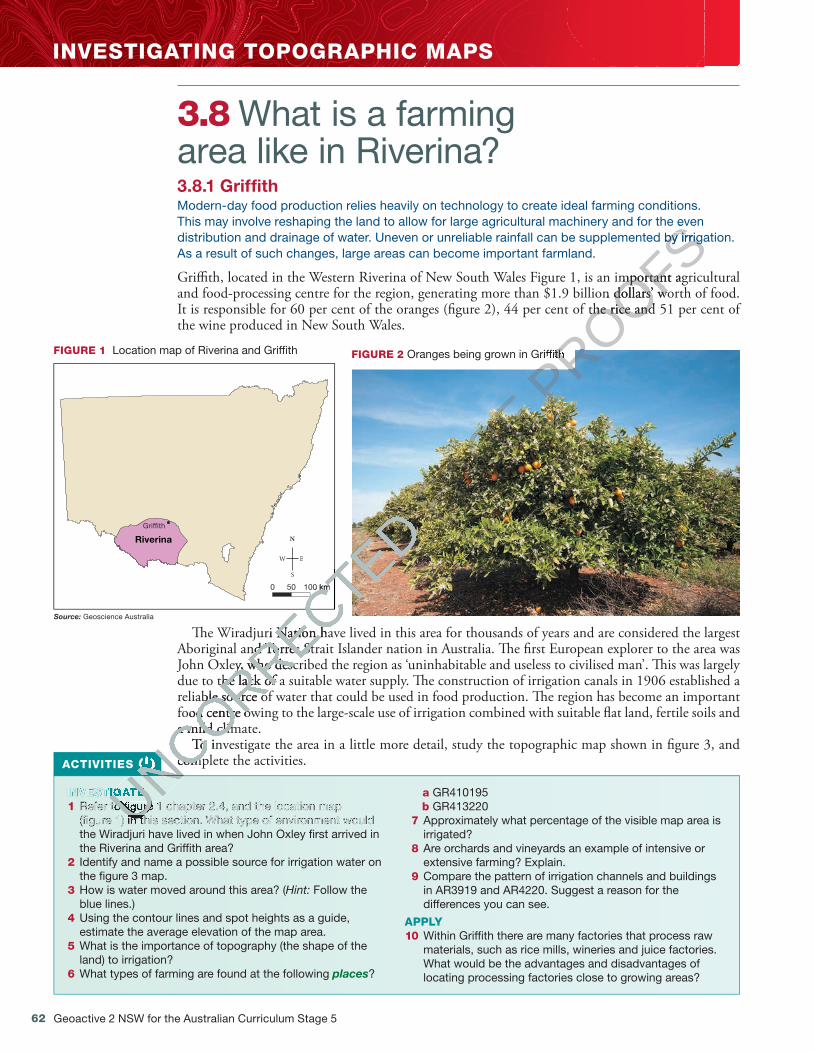
62
INVESTIGATING TOPOGRAPHIC MAPS
Geoactive 2 NSW for the Australian Curriculum Stage 5
3.8 What is a farming area like in Riverina? 3.8.1 Griffith Modern-day food production relies heavily on technology to create ideal farming conditions. This may involve reshaping the land to allow for large agricultural machinery and for the even distribution and drainage of water. Uneven or unreliable rainfall can be supplemented by irrigation. As a result of such changes, large areas can become important farmland.
Gri� th, located in the Western Riverina of New South Wales Figure 1, is an important agricultural and food-processing centre for the region, generating more than $1.9 billion dollars’ worth of food. It is responsible for 60 per cent of the oranges (� gure 2), 44 per cent of the rice and 51 per cent of the wine produced in New South Wales.
FIGURE 2 Oranges being grown in Grif� th
Grif�th
Riverina
Source: Geoscience Australia
0 50 100 km
FIGURE 1 Location map of Riverina and Grif� th
� e Wiradjuri Nation have lived in this area for thousands of years and are considered the largest Aboriginal and Torres Strait Islander nation in Australia. � e � rst European explorer to the area was John Oxley, who described the region as ‘uninhabitable and useless to civilised man’. � is was largely due to the lack of a suitable water supply. � e construction of irrigation canals in 1906 established a reliable source of water that could be used in food production. � e region has become an important food centre owing to the large-scale use of irrigation combined with suitable � at land, fertile soils and a mild climate.
To investigate the area in a little more detail, study the topographic map shown in � gure 3, and complete the activities. ACTIVITIES
INVESTIGATE 1 Refer to � gure 1 chapter 2.4, and the location map
(� gure 1) in this section. What type of environment would the Wiradjuri have lived in when John Oxley � rst arrived in the Riverina and Grif� th area?
2 Identify and name a possible source for irrigation water on the � gure 3 map.
3 How is water moved around this area? ( Hint: Follow the blue lines.)
4 Using the contour lines and spot heights as a guide, estimate the average elevation of the map area.
5 What is the importance of topography (the shape of the land) to irrigation?
6 What types of farming are found at the following places ?
a GR410195 b GR413220
7 Approximately what percentage of the visible map area is irrigated?
8 Are orchards and vineyards an example of intensive or extensive farming? Explain.
9 Compare the pattern of irrigation channels and buildings in AR3919 and AR4220. Suggest a reason for the differences you can see.
APPLY 10 Within Grif� th there are many factories that process raw
materials, such as rice mills, wineries and juice factories. What would be the advantages and disadvantages of locating processing factories close to growing areas?
c03BiomesProduceFood.indd 62 19/10/16 8:08 am
UNCORRECTED
UNCORRECTED
UNCORRECTED
UNCORRECTED
UNCORRECTED 0 50 100 km
UNCORRECTED 0 50 100 km
� e Wiradjuri Nation have lived in this area for thousands of years and are considered the largest
UNCORRECTED
� e Wiradjuri Nation have lived in this area for thousands of years and are considered the largest Aboriginal and Torres Strait Islander nation in Australia. � e � rst European explorer to the area was
UNCORRECTED
Aboriginal and Torres Strait Islander nation in Australia. � e � rst European explorer to the area was John Oxley, who described the region as ‘uninhabitable and useless to civilised man’. � is was largely
UNCORRECTED
John Oxley, who described the region as ‘uninhabitable and useless to civilised man’. � is was largely due to the lack of a suitable water supply. � e construction of irrigation canals in 1906 established a
UNCORRECTED
due to the lack of a suitable water supply. � e construction of irrigation canals in 1906 established a reliable source of water that could be used in food production. � e region has become an important
UNCORRECTED
reliable source of water that could be used in food production. � e region has become an important food centre owing to the large-scale use of irrigation combined with suitable � at land, fertile soils and
UNCORRECTED
food centre owing to the large-scale use of irrigation combined with suitable � at land, fertile soils and a mild climate.
UNCORRECTED
a mild climate. To investigate the area in a little more detail, study the topographic map shown in � gure 3, and
UNCORRECTED
To investigate the area in a little more detail, study the topographic map shown in � gure 3, and complete the activities.
UNCORRECTED
complete the activities.
UNCORRECTED
UNCORRECTED
UNCORRECTED
UNCORRECTED
UNCORRECTED
INVESTIGATE UNCORRECTED
INVESTIGATE Refer to � gure 1 chapter 2.4, and the location map UNCORRECTED
Refer to � gure 1 chapter 2.4, and the location map (� gure 1) in this section. What type of environment would UNCORRECTED
(� gure 1) in this section. What type of environment would UNCORRECTED PAGE P
ROOFSThis may involve reshaping the land to allow for large agricultural machinery and for the even
PROOFSThis may involve reshaping the land to allow for large agricultural machinery and for the even distribution and drainage of water. Uneven or unreliable rainfall can be supplemented by irrigation.
PROOFSdistribution and drainage of water. Uneven or unreliable rainfall can be supplemented by irrigation.
Gri� th, located in the Western Riverina of New South Wales Figure 1, is an important agricultural
PROOFS Gri� th, located in the Western Riverina of New South Wales Figure 1, is an important agricultural and food-processing centre for the region, generating more than $1.9 billion dollars’ worth of food.
PROOFSand food-processing centre for the region, generating more than $1.9 billion dollars’ worth of food. It is responsible for 60 per cent of the oranges (� gure 2), 44 per cent of the rice and 51 per cent of
PROOFSIt is responsible for 60 per cent of the oranges (� gure 2), 44 per cent of the rice and 51 per cent of
PROOFS
PROOFSOranges being grown in Grif� th
PROOFSOranges being grown in Grif� th

Chapter 3 Biomes produce food 63
20
19
18
17
40 41 42 43
21
22
Principal road; Built-up areas; Locality ...............
Secondary road; Bridge; Causeway ..................
Multiple track railway; Station or siding ............
Single track railway; Bridge, Tunnel ..................
Homestead; Building/s; Ruin ..............................
Orchard, plantation or vineyard; Windbreak ......
Irrigation channel .............................................
Key
SCALE 1:250 0000 1 2 3 4 5 6 7 8 9 10 20 25 30 35 40 kilometres15
Source: Commonwealth of Australia (Geoscience Australia).
FIGURE 3 Topographic map extract, Grif� th, New South Wales
c03BiomesProduceFood.indd 63 19/10/16 8:08 am
UNCORRECTED PAGE P
ROOFS

64 Geoactive 2 NSW for the Australian Curriculum Stage 5
3.10 Why is rice an important food crop?3.10.1 Factors affecting rice production in AsiaRice is the seed of a semi-aquatic grass. In warm climates, in more than 100 countries, it is cultivated extensively for its edible grain. Rice is one of the most important staple foods of more than half of the world’s population, and it in�uences the livelihoods and economies of several billion people. In Asia, rice provides about 49 per cent of the calories and 39 per cent of the protein in people’s diet. In 2015, approximately 160 million hectares of rice were harvested worldwide, and 101.5 kilograms were produced for each person on Earth.
Figure 1 shows that in 2014 the largest concentration of rice was grown in Asia. Around 163 million hectares are cultivated with this crop, producing 91 per cent of the world’s rice. Of this, 48 million hectares and 30 per cent of the global rice crop were in South-East Asia alone.
Countries with the largest areas under rice cultivation are India, China, Indonesia, Bangladesh, �ailand, Vietnam, Myanmar and the Philippines, with 80 per cent of the total rice area.
Climate and topographyRice can be grown in a range of environments that are hot or cool, wet or dry. It can be grown at sea level on coastal plains and at high altitudes in the Himalayas. However, ideal conditions in South-East Asia are high temperatures, large amounts of water, �at land and fertile soil.
In Yunnan Province, China, the mountain slopes have been cultivated in terraced rice paddies by the Hani people for at least 1300 years (see �gure 2). �e terraces stop erosion and surface run-o� and create �at land area for cultivation in otherwise very steep terrain.
3.9 SkillBuilder: Describing patterns and correlations on a topographic map What are patterns and correlations on a topographic map?A pattern is the way in which features are distributed or spread. A correlation shows how two or more features are interconnected — that is, the relationship between the features. Patterns and correlations in a topographic map can show us cause-and-effect connections.
ONLINE ONLY
eLessonWatch this video to learn how to describe patterns and correlations in a topographic map.
Searchlight ID: eles-1729
InteractivityTry this interactivity to learn how to describe patterns and correlations in a topographic map.
Searchlight ID: int-3347
c03BiomesProduceFood.indd 64 19/10/16 8:08 am
UNCORRECTED
UNCORRECTED Why is rice an important
UNCORRECTED Why is rice an important
food crop?
UNCORRECTED food crop?3.10.1 Factors affecting rice production in Asia
UNCORRECTED
3.10.1 Factors affecting rice production in AsiaRice is the seed of a semi-aquatic grass. In warm climates, in more than 100 countries, it is
UNCORRECTED
Rice is the seed of a semi-aquatic grass. In warm climates, in more than 100 countries, it is cultivated extensively for its edible grain. Rice is one of the most important staple foods of
UNCORRECTED
cultivated extensively for its edible grain. Rice is one of the most important staple foods of more than half of the world’s population, and it in�uences the livelihoods and economies of
UNCORRECTED
more than half of the world’s population, and it in�uences the livelihoods and economies of several billion people. In Asia, rice provides about 49 per cent of the calories and 39 per cent of
UNCORRECTED
several billion people. In Asia, rice provides about 49 per cent of the calories and 39 per cent of the protein in people’s diet. In 2015, approximately 160 million hectares of rice were harvested
UNCORRECTED
the protein in people’s diet. In 2015, approximately 160 million hectares of rice were harvested worldwide, and 101.5 kilograms were produced for each person on Earth.
UNCORRECTED
worldwide, and 101.5 kilograms were produced for each person on Earth.
Figure 1 shows that in 2014 the largest concentration of rice was grown in Asia. Around 163 million
UNCORRECTED
Figure 1 shows that in 2014 the largest concentration of rice was grown in Asia. Around 163 million hectares are cultivated with this crop, producing 91 per cent of the world’s rice. Of this, 48 million
UNCORRECTED
hectares are cultivated with this crop, producing 91 per cent of the world’s rice. Of this, 48 million hectares and 30 per cent of the global rice crop were in South-East Asia alone.
UNCORRECTED
hectares and 30 per cent of the global rice crop were in South-East Asia alone.
PAGE
PAGE
PAGE
PAGE PROOFS
PROOFSSearchlight ID: eles-1729
PROOFSSearchlight ID: eles-1729
PROOFS
PROOFS
PROOFSInteractivity
PROOFSInteractivityTry this interactivity to learn
PROOFSTry this interactivity to learn how to describe patterns and
PROOFShow to describe patterns and correlations in a topographic
PROOFS
correlations in a topographic map.PROOFS
map.PROOFS
PROOFS
PROOFS
PROOFS

Chapter 3 Biomes produce food 65
Arctic Circle
Tropic of Cancer
Equator
Tropic of Capricorn
PACIFIC
ARCTIC OCEAN
ATLANTIC
OCEANOCEAN
INDIAN
OCEAN
World rice production (tonnes), 2014
100 000 000206 507 400
50 000 00010 000 0000
20000 4000 km
Source: Food and Agricultural Organization of the United Nations
FIGURE 1 World rice production 2014
FIGURE 2 Spectacular rice terraces in Yunnan Province, China. These terraces are at an elevation of 1570 metres.
IrrigationTraditional rice cultivation involves �ooding the paddy �elds (padi meaning ‘rice plant’ in Malay) for part of the year. �ese �elds are small, and earth embankments (bunds) surround them. Rice farmers usually plant the seeds �rst in little seedbeds and transfer them into �ooded paddy �elds, which are already ploughed (see �gure 3). Canals carry water to and from the �elds. Houses and settlements are often located on embankments or raised islands near the rice �elds.
Approximately 45 per cent of the rice area in South-East Asia is irrigated, with the largest areas being found in Indonesia, Vietnam, the Philippines and �ailand. High-yielding areas of irrigated rice can also be found in China, Japan and the Republic of Korea. Because water is available for most of the year in these places, farmers can grow rice all year long. �is intensive scale of farming can produce two and sometimes three crops a year.
c03BiomesProduceFood.indd 65 19/10/16 8:08 am
UNCORRECTED Traditional rice cultivation involves �ooding the paddy �elds (
UNCORRECTED Traditional rice cultivation involves �ooding the paddy �elds (part of the year. �ese �elds are small, and earth embankments (
UNCORRECTED part of the year. �ese �elds are small, and earth embankments (usually plant the seeds �rst in little seedbeds and transfer them into �ooded paddy �elds, which are
UNCORRECTED usually plant the seeds �rst in little seedbeds and transfer them into �ooded paddy �elds, which are already ploughed (see �gure 3). Canals carry water to and from the �elds. Houses and settlements
UNCORRECTED already ploughed (see �gure 3). Canals carry water to and from the �elds. Houses and settlements
UNCORRECTED
UNCORRECTED
UNCORRECTED
Spectacular rice terraces in Yunnan Province, China.
UNCORRECTED
Spectacular rice terraces in Yunnan Province, China. These terraces are at an elevation of 1570 metres.
UNCORRECTED
These terraces are at an elevation of 1570 metres.
are often located on embankments or raised islands near the rice �elds.
UNCORRECTED are often located on embankments or raised islands near the rice �elds.
Approximately 45 per cent of the rice area in South-East Asia is irrigated, with the largest areas
UNCORRECTED Approximately 45 per cent of the rice area in South-East Asia is irrigated, with the largest areas
being found in Indonesia, Vietnam, the
UNCORRECTED being found in Indonesia, Vietnam, the P
UNCORRECTED Philippines and �ailand. High-yielding areas of irrigated
UNCORRECTED hilippines and �ailand. High-yielding areas of irrigated
rice can also be found in China, Japan and the Republic of Korea. Because water is available for most
UNCORRECTED
rice can also be found in China, Japan and the Republic of Korea. Because water is available for most of the year in these places, farmers can grow rice all year long. �is
UNCORRECTED
of the year in these places, farmers can grow rice all year long. �is produce two and sometimes three crops a year.
UNCORRECTED
produce two and sometimes three crops a year.
PAGE
PAGE
PAGE
PAGE
PAGE World rice production (tonnes), 2014
PAGE World rice production (tonnes), 2014
PAGE
PAGE
PAGE
PAGE
PAGE
PAGE
PAGE
PAGE
PAGE
PAGE
PAGE
PAGE
PAGE
PAGE
PAGE
PAGE
PAGE
padiPAGE
padi
PROOFS
PROOFS
PROOFS
PROOFS
PROOFS
PROOFS
PROOFS
PROOFS
PROOFS
PROOFS
PROOFS
PROOFS
PROOFS
PROOFS
PROOFS
PROOFS
PROOFS
PROOFS
PROOFS
PROOFS
PROOFS
PROOFS
PROOFS
PROOFS
PROOFS
PROOFS
PROOFS
PROOFS
PROOFS
PROOFS
PROOFS
PROOFS
PROOFS
PROOFS
PROOFS
PROOFS
PROOFS
PROOFS
PROOFS
PROOFS
PROOFS
PROOFS
PROOFS
PROOFS
PROOFS
PROOFS
PROOFS
PROOFS
PROOFS
PROOFS
PROOFS
PROOFS
PROOFS
PROOFS
PROOFS
PROOFS
PROOFS
PROOFS
PROOFS
PROOFS
PROOFS
PROOFS
PROOFS
PROOFS
PROOFS
PROOFS
PROOFS
PROOFS
PROOFS
PROOFS
PROOFS
PROOFS
PROOFS
PROOFS
PROOFS
PROOFS
PROOFS
PROOFS
PROOFS
PROOFS
PROOFS
PROOFS
PROOFS
PROOFS
PROOFS
PROOFS
PROOFS
PROOFS
PROOFS
PROOFS
PROOFS
PROOFS
PROOFS
PROOFS
PROOFS
PROOFS
PROOFS
PROOFS
PROOFS
PROOFS
PROOFS
PROOFS
PROOFS
PROOFS
PROOFS
PROOFS
PROOFS
PROOFS
PROOFS
PROOFS
PROOFS
PROOFS
PROOFS
PROOFS
PROOFS
PROOFS
PROOFS
PROOFS
PROOFS
PROOFS
PROOFS
PROOFS
PROOFS
PROOFS
PROOFS
PROOFS
PROOFS
PROOFS
PROOFS
PROOFS
PROOFS
PROOFS
PROOFS
PROOFS
PROOFS
PROOFS
PROOFS
PROOFS
PROOFS
PROOFS
PROOFS
PROOFS
PROOFS
PROOFS
PROOFS
PROOFS
PROOFS
PROOFS
PROOFS
PROOFS
PROOFS
PROOFS
PROOFS
PROOFS
PROOFS
PROOFS
PROOFS
PROOFS
PROOFS
PROOFS
PROOFS
PROOFS
PROOFS
PROOFS
PROOFS
PROOFS
PROOFS
PROOFS
PROOFS
PROOFS
PROOFS
PROOFS
PROOFS
PROOFS
PROOFS
PROOFS
PROOFS
PROOFS
PROOFS
PROOFS
PROOFS
PROOFS
PROOFS
PROOFS
PROOFS
PROOFS
PROOFS
PROOFS
PROOFS
PROOFS
PROOFS
PROOFS
PROOFS
PROOFS
PROOFS
PROOFS
PROOFS
PROOFS
PROOFSATLANTIC
PROOFSATLANTIC
PROOFS
PROOFS
World rice production (tonnes), 2014PROOFS
World rice production (tonnes), 2014

66 Geoactive 2 NSW for the Australian Curriculum Stage 5
Interactivity How is rice grown? Use this interactivity to further your understanding of how rice is cultivated in different places. Searchlight ID: int-3322
FIGURE 4 Hybrid rice seeds Upland rice is grown where there is not enough moisture to nurture the crops; an example of such cultivation takes place in Laos. � is method produces fewer rice varieties, since only a small amount of nutrients are available compared to rice grown in paddy � elds.
Pests and diseases Rice yields can be limited if any of the following conditions exist: • poor production management • losses caused by weeds (biotic factor) • pests and diseases (biotic factor) • inadequate land formation and irrigation
water • inadequate drainage that leads to a build-up
of salinity and alkalinity.
Technology Agricultural biotechnology, especially in China, has produced rice that is resistant to pests. � ere are also genes for herbicide resistance, disease resistance, salt and drought tolerance, grain quality and photosynthetic e� ciency. Genetic engineering may be the way of the future in rice cultivation in some parts of the world (� gure 4).
However, in the Philippines, a new strain of rice has been developed that grows well in soils lacking phosphorus. � is could change crop yields considerably, and has been a result of cross breeding rather than genetic engineering.
Environmental issues Increasing temperatures, due to global warming, may be causing a drop in rice production in Asia, where more than 90 per cent of the world’s rice is produced and consumed. � e Food and Agri-culture Organization of the United Nations (FAO) has found that in six of Asia’s most important rice-producing countries — China, India, Indonesia, the Philippines, � ailand and Vietnam — rising temperatures over the last 25 years have led to a 10–20 per cent decline in rice output.
FIGURE 3 Planting rice in paddy � elds in north-east Thailand
bund (embankment)padi (rice plant)
c03BiomesProduceFood.indd 66 19/10/16 8:08 am
UNCORRECTED
UNCORRECTED
UNCORRECTED
UNCORRECTED
UNCORRECTED
Technology
UNCORRECTED
Technology Agricultural biotechnology, especially in China, has produced rice that is resistant to pests. � ere are
UNCORRECTED
Agricultural biotechnology, especially in China, has produced rice that is resistant to pests. � ere are also genes for herbicide resistance, disease resistance, salt and drought tolerance, grain quality and
UNCORRECTED
also genes for herbicide resistance, disease resistance, salt and drought tolerance, grain quality and
PAGE
PAGE Upland rice is grown where there is not enough
PAGE Upland rice is grown where there is not enough
moisture to nurture the crops; an example of
PAGE moisture to nurture the crops; an example of such cultivation takes place in Laos. � is method PAGE such cultivation takes place in Laos. � is method PAGE P
ROOFS
PROOFS
PROOFS
PROOFS(embankment)
PROOFS(embankment)

Chapter 3 Biomes produce food 67
Scientists state that if rice production methods cannot be changed, or if new rice strains able to withstand higher temperatures cannot be developed, there will be a loss in rice production over the next few decades as days and nights get hotter. People may need to turn to a new staple crop.
Rice growing is eco-friendly and has a positive impact on the environment. Rice �elds create a wetland habitat for many species of birds, mammals and reptiles. Without rice farming, wetland environments created by �ooded rice �elds would be vastly reduced.
3.10.2 Factors affecting rice production in AustraliaClimate and topographyEighty per cent of rice produced in Australia consists of temperate varieties that suit climates with high summer temperatures and low humidity. Rice is grown in the Murrumbidgee valleys of New South Wales (�gure 5) and the Murray valleys of New South Wales and Victoria. �e scale of produc-tion is sophisticated.
Sowing and irrigationIn Australia, rice grows as an irrigated summer crop from September to March. Most of it is sown by aircraft rather than planted by hand. Experienced agricultural pilots use satellite guidance technology to broadcast seed accurately over the �elds.
Before sowing, the seed is soaked for 24 hours and drained for 24 hours, leaving a tiny shoot visible on the seed. Once sown, it slowly settles in the soft mud, and within three to four days each plant develops a substantial root system and leaf shoot. After planting, fresh water is released from irriga-tion supply channels to �ow across each paddy �eld until the rice plants are well established.
Most countries grow rice as a monoculture, whereas Australian rice grows as part of a unique farming system. Farmers use a crop rotation cycle across the whole farm over four to �ve years. �is means that the growers have other agricultural enterprises on the farm as well as rice. �is system, designed for e�ciency, sustainability and safety, means Australian growers maintain water savings, have increased soil nutrients, higher yields and much healthier crops.
Once Australian rice growers harvest their rice (�gure 6), they use the subsoil moisture remaining in the soil to plant another crop — either a wheat crop or pasture for animals. �is form of rotation is the most e�cient in natural resource use and agricultural terms.
Pests and diseasesRice bays (areas contained by embankments — see �gure 5) are treated with a chemical application, which prevents damage by pests and weeds. Without this treatment, crop losses would be extensive. In the last 100 days before harvesting, the rice plant has no chemical applications, so that when it is harvested, it is virtually chemical free.
crop rotation a procedure that involves the rotation of crops, so that no bed or plot sees the same crop in successive seasons
FIGURE 5 Murrumbidgee irrigation area rice �elds
c03BiomesProduceFood.indd 67 19/10/16 8:08 am
UNCORRECTED
In Australia, rice grows as an irrigated summer crop from September to March. Most of it is sown by
UNCORRECTED
In Australia, rice grows as an irrigated summer crop from September to March. Most of it is sown by aircraft rather than planted by hand. Experienced agricultural pilots use satellite guidance technology
UNCORRECTED
aircraft rather than planted by hand. Experienced agricultural pilots use satellite guidance technology to broadcast seed accurately over the �elds.
UNCORRECTED
to broadcast seed accurately over the �elds.Before sowing, the seed is soaked for 24 hours and drained for 24 hours, leaving a tiny shoot visible
UNCORRECTED
Before sowing, the seed is soaked for 24 hours and drained for 24 hours, leaving a tiny shoot visible on the seed. Once sown, it slowly settles in the soft mud, and within three to four days each plant
UNCORRECTED
on the seed. Once sown, it slowly settles in the soft mud, and within three to four days each plant develops a substantial root system and leaf shoot. After planting, fresh water is released from irriga
UNCORRECTED
develops a substantial root system and leaf shoot. After planting, fresh water is released from irriga
UNCORRECTED
tion supply channels to �ow across each paddy �eld until the rice plants are well established.
UNCORRECTED
tion supply channels to �ow across each paddy �eld until the rice plants are well established.Most countries grow rice as a monoculture, whereas Australian rice grows as part of a unique
UNCORRECTED
Most countries grow rice as a monoculture, whereas Australian rice grows as part of a unique farming system. Farmers use a
UNCORRECTED
farming system. Farmers use a means that the growers have other agricultural enterprises on the farm as well as rice. �is system, UNCORRECTED
means that the growers have other agricultural enterprises on the farm as well as rice. �is system, UNCORRECTED
designed for e�ciency, sustainability and safety, means Australian growers maintain water savings, UNCORRECTED
designed for e�ciency, sustainability and safety, means Australian growers maintain water savings, have increased soil nutrients, higher yields and much healthier crops.UNCORRECTED
have increased soil nutrients, higher yields and much healthier crops.UNCORRECTED PAGE P
ROOFS
PROOFS

68 Geoactive 2 NSW for the Australian Curriculum Stage 5
Technology Most farms use laser-guided land levelling techniques to prepare the ground for production. � is gives farmers precise control over the � ow of water on and o� the land. Such measurement strategies have contributed to a 60 per cent improvement in water e� ciency. Most of the equipment used on rice farms is � tted with computer-aided devices, such as GPS (global positioning systems), CAD (computer-aided Design), GIS (geographical information systems) and remote sensing. Australian rice growers are the most e� cient and productive in the world.
Environmental issues � e rice industry encourages biodiversity enhancement and greenhouse gas reduction strategies. Some farms in southern New South Wales are avoiding the use of chemical fertilisers and pesticides by converting farms to biodynamic practices, and have avoided salinity by planting red gums.
biodiversity the variety of plant and animal life within an area
Deepen your understanding of this topic with related case studies and questions. Rice
FIGURE 6 Harvesting rice near Grif� th, New South Wales
ACTIVITIES
Weblink Terraced rice
IDENTIFY 1 Refer to � gure 1. Which countries produce
most of the world’s rice? 2 What is meant by the term monoculture ?
EXPLAIN 3 Explain why places in Asia are ideally suited to
rice growing. 4 Use the Terraced rice weblink in your
eBookPLUS to explain how the terraced rice � elds shown in � gure 2 have been formed.
5 Explain the environmental issues that may affect future rice production.
6 Describe and explain the similarities and differences between the rice cultivation methods in Asia and Australia.
INVESTIGATE 7 Investigate two different rice growing places
in Asia and describe the reasons for the different environments .
8 Investigate an example of an Australian rice farm and outline its yearly rice-growing cycle.
9 Research the interconnection between rice-growing and the Murray River to ensure a sustainable environment .
PREDICT 10 Predict how technology will in� uence
changes to rice cultivation in both Asia and Australia.
c03BiomesProduceFood.indd 68 19/10/16 8:08 am
UNCORRECTED have contributed to a 60 per cent improvement in water e� ciency. Most of the equipment used on
UNCORRECTED have contributed to a 60 per cent improvement in water e� ciency. Most of the equipment used on rice farms is � tted with computer-aided devices, such as GPS (global positioning systems), CAD
UNCORRECTED rice farms is � tted with computer-aided devices, such as GPS (global positioning systems), CAD (computer-aided Design), GIS (geographical information systems) and remote sensing. Australian
UNCORRECTED (computer-aided Design), GIS (geographical information systems) and remote sensing. Australian rice growers are the most e� cient and productive in the world.
UNCORRECTED rice growers are the most e� cient and productive in the world.
Environmental issues
UNCORRECTED Environmental issues � e rice industry encourages
UNCORRECTED � e rice industry encourages strategies. Some farms in southern New South Wales are avoiding the use of chemical fertilisers
UNCORRECTED strategies. Some farms in southern New South Wales are avoiding the use of chemical fertilisers and pesticides by converting farms to biodynamic practices, and have avoided salinity by planting
UNCORRECTED
and pesticides by converting farms to biodynamic practices, and have avoided salinity by planting
UNCORRECTED
ACTIVITIES
UNCORRECTED
ACTIVITIES
UNCORRECTED
UNCORRECTED
UNCORRECTED
UNCORRECTED
IDENTIFY
UNCORRECTED
IDENTIFY 1
UNCORRECTED
1 Refer to � gure 1. Which countries produce
UNCORRECTED
Refer to � gure 1. Which countries produce most of the world’s rice?
UNCORRECTED
most of the world’s rice? 2
UNCORRECTED
2 What is meant by the term
UNCORRECTED
What is meant by the term
UNCORRECTED
UNCORRECTED
UNCORRECTED
UNCORRECTED
UNCORRECTED
UNCORRECTED
EXPLAIN
UNCORRECTED
EXPLAIN
UNCORRECTED PAGE
Most farms use laser-guided land levelling techniques to prepare the ground for production. � is
PAGE Most farms use laser-guided land levelling techniques to prepare the ground for production. � is gives farmers precise control over the � ow of water on and o� the land. Such measurement strategies PAGE gives farmers precise control over the � ow of water on and o� the land. Such measurement strategies have contributed to a 60 per cent improvement in water e� ciency. Most of the equipment used on PAGE
have contributed to a 60 per cent improvement in water e� ciency. Most of the equipment used on rice farms is � tted with computer-aided devices, such as GPS (global positioning systems), CAD PAGE
rice farms is � tted with computer-aided devices, such as GPS (global positioning systems), CAD PAGE PROOFS

Chapter 3 Biomes produce food 69
3.11 Why is cacao a special food crop? To access this subtopic, go to your eBookPLUS at www.jacplus.com.au.
ONLINE ONLY
3.12 Daly River: a sustainable ecosystem?To access this subtopic, go to your eBookPLUS at www.jacplus.com.au.
ONLINE ONLY
3.13 ReviewTo access this resource, go to your eBookPLUS at www.jacplus.com.au.
ONLINE ONLY
c03BiomesProduceFood.indd 69 19/10/16 8:08 am
UNCORRECTED
UNCORRECTED
UNCORRECTED PAGE
PAGE www.jacplus.com.auPAGE www.jacplus.com.auPAGE
PAGE PROOFS
PROOFS