Biological Conservation - apclevenger.weebly.com · 1/20/2018 · the southeast (IBGE, 2017). The...
10
Contents lists available at ScienceDirect Biological Conservation journal homepage: www.elsevier.com/locate/biocon Giant anteater (Myrmecophaga tridactyla) conservation in Brazil: Analysing the relative effects of fragmentation and mortality due to roads Fernando A.S. Pinto a,b, ⁎ , Alex Bager a,c , Anthony P. Clevenger d , Clara Grilo b a Centro Brasileiro de Estudos em Ecologia de Estradas, Universidade Federal de Lavras, Campus Universitário, PO Box 3037, CEP 37200-000 Lavras, Minas Gerais, Brazil b Setor de Ecologia e Conservação, Departamento de Biologia, Universidade Federal de Lavras, PO Box 3037, CEP 37200-000 Lavras, Minas Gerais, Brazil c Programa de Pós-Graduação em Análise e Modelagem de Sistemas Ambientais, Universidade Federal de Minas Gerais, Belo Horizonte, MG, Brazil d Western Transportation Institute, Montana State University, PO Box 174250, Bozeman, MT, USA ARTICLE INFO Keywords: Giant anteater Myrmecophaga tridactyla Patch size Population persistence Road density Spatial explicit population model ABSTRACT Road networks can have serious ecological consequences for many species, mainly through habitat fragmen- tation and mortality due to collisions with vehicles. One example of a species impacted by roads is the giant anteater (Myrmecophaga tridactyla), currently listed as Vulnerable by IUCN. Here we analysed the relative effect of fragmentation and mortality due to roads on giant anteater populations and show the critical areas for their persistence in Brazil. We estimated minimum patch size and maximum road density to evaluate the impact of the road network and observed road-kills on this species. We explored different scenarios by varying values of dispersal capacity to estimate the minimum patch size, and also of population densities to estimate maximum road density for giant anteater persistence. Our findings indicated that the minimum patch size can be from 498 to 247 km 2 and the maximum road density can vary between 0.21 and 0.55 km/km 2 in pessimist and optimistic scenarios, respectively. In Brazil, habitat fragmentation seemed to have a major impact over giant anteater populations. Habitat fragmentation due to roads seemed to have a more negative effect than mortality due to collisions with vehicles. Critical areas for the species persistence can represent 32% of its range in the optimistic scenario with 18% of suitable patches below the minimum size and 0.1% above the maximum road density. This study provides insights and implications for road networks on giant anteater populations in Brazil and guidance on road density and patch size thresholds for land managers and road agencies charged with planning ecolo- gically sustainable roads in Brazil. 1. Introduction Habitat fragmentation constitutes a serious threat for mammals worldwide (Crooks et al., 2017) as 27% of mammals are at risk of ex- tinction, and 40% of those at risk due to habitat loss (Schipper et al., 2008). Road networks are one of the primary anthropogenic con- tributors to habitat loss and fragmentation, and have been highlighted as primary drivers of biodiversity decline and species extinction (Rands et al., 2010; Crooks et al., 2017). Fragmentation can create adverse edge effects on the boundaries of habitat patches (Haddad et al., 2015), decrease landscape connectivity (Cushman, 2006; Jackson and Fahrig, 2011), act as a barrier for animal movement and gene flow (Chen and Koprowski, 2016), and reduce genetic diversity (Balkenhol et al., 2013), all of which can lead to local declines of populations (Bender et al., 1998; Gibbon et al., 2000). Mortality from collisions with vehicles is a major negative effect of roads on wildlife (Mumme et al., 2000; Gibbs and Shriver, 2002). In general, high mobility species have higher chances of encountering roads compared to less mobile species, and thus, are more affected by road-related mortality (Rytwinski and Fahrig, 2012). The loss of in- dividuals by road mortality can have a strong effect on population viability especially for species with low reproductive rates (Ferreras et al., 2001; Haines et al., 2006; Medici and Desbiez, 2012; Diniz and Brito, 2013). The importance of road networks to species ecology (e.g. re- production, behaviour, habitat use) has motivated work on minimum road density estimation. For example, wolves (Canis lupus) and pumas (Puma concolor) do not maintain breeding groups in areas with road densities > 0.6 km/km 2 (Thiel, 1985; Van Dyke et al., 1986). Basille et al. (2013) observed that Eurasian lynx (Lynx lynx) in southern Norway avoided using areas with a road density > 0.41 km/km 2 . While these studies provided a road density threshold that can influence the https://doi.org/10.1016/j.biocon.2018.10.023 Received 20 January 2018; Received in revised form 26 September 2018; Accepted 19 October 2018 ⁎ Corresponding author at: Centro Brasileiro de Estudos em Ecologia de Estradas, Universidade Federal de Lavras, Campus Universitário, PO Box 3037, CEP 37200- 000 Lavras, Minas Gerais, Brazil. E-mail address: [email protected] (F.A.S. Pinto). Dkqnqikecn"Eqpugtxcvkqp"44:"*423:+"36:É379 2228/54291"ª"423:"Rwdnkujgf"d{"Gnugxkgt"Nvf0 V
Transcript of Biological Conservation - apclevenger.weebly.com · 1/20/2018 · the southeast (IBGE, 2017). The...

Contents lists available at ScienceDirect
Biological Conservation
journal homepage: www.elsevier.com/locate/biocon
Giant anteater (Myrmecophaga tridactyla) conservation in Brazil: Analysingthe relative effects of fragmentation and mortality due to roads
Fernando A.S. Pintoa,b,⁎, Alex Bagera,c, Anthony P. Clevengerd, Clara Griloba Centro Brasileiro de Estudos em Ecologia de Estradas, Universidade Federal de Lavras, Campus Universitário, PO Box 3037, CEP 37200-000 Lavras, Minas Gerais, Brazilb Setor de Ecologia e Conservação, Departamento de Biologia, Universidade Federal de Lavras, PO Box 3037, CEP 37200-000 Lavras, Minas Gerais, Brazilc Programa de Pós-Graduação em Análise e Modelagem de Sistemas Ambientais, Universidade Federal de Minas Gerais, Belo Horizonte, MG, BrazildWestern Transportation Institute, Montana State University, PO Box 174250, Bozeman, MT, USA
A R T I C L E I N F O
Keywords:Giant anteaterMyrmecophaga tridactylaPatch sizePopulation persistenceRoad densitySpatial explicit population model
A B S T R A C T
Road networks can have serious ecological consequences for many species, mainly through habitat fragmen-tation and mortality due to collisions with vehicles. One example of a species impacted by roads is the giantanteater (Myrmecophaga tridactyla), currently listed as Vulnerable by IUCN. Here we analysed the relative effectof fragmentation and mortality due to roads on giant anteater populations and show the critical areas for theirpersistence in Brazil. We estimated minimum patch size and maximum road density to evaluate the impact of theroad network and observed road-kills on this species. We explored different scenarios by varying values ofdispersal capacity to estimate the minimum patch size, and also of population densities to estimate maximumroad density for giant anteater persistence. Our findings indicated that the minimum patch size can be from 498to 247 km2 and the maximum road density can vary between 0.21 and 0.55 km/km2 in pessimist and optimisticscenarios, respectively. In Brazil, habitat fragmentation seemed to have a major impact over giant anteaterpopulations. Habitat fragmentation due to roads seemed to have a more negative effect than mortality due tocollisions with vehicles. Critical areas for the species persistence can represent 32% of its range in the optimisticscenario with 18% of suitable patches below the minimum size and 0.1% above the maximum road density. Thisstudy provides insights and implications for road networks on giant anteater populations in Brazil and guidanceon road density and patch size thresholds for land managers and road agencies charged with planning ecolo-gically sustainable roads in Brazil.
1. Introduction
Habitat fragmentation constitutes a serious threat for mammalsworldwide (Crooks et al., 2017) as 27% of mammals are at risk of ex-tinction, and 40% of those at risk due to habitat loss (Schipper et al.,2008). Road networks are one of the primary anthropogenic con-tributors to habitat loss and fragmentation, and have been highlightedas primary drivers of biodiversity decline and species extinction (Randset al., 2010; Crooks et al., 2017). Fragmentation can create adverseedge effects on the boundaries of habitat patches (Haddad et al., 2015),decrease landscape connectivity (Cushman, 2006; Jackson and Fahrig,2011), act as a barrier for animal movement and gene flow (Chen andKoprowski, 2016), and reduce genetic diversity (Balkenhol et al.,2013), all of which can lead to local declines of populations (Benderet al., 1998; Gibbon et al., 2000).
Mortality from collisions with vehicles is a major negative effect of
roads on wildlife (Mumme et al., 2000; Gibbs and Shriver, 2002). Ingeneral, high mobility species have higher chances of encounteringroads compared to less mobile species, and thus, are more affected byroad-related mortality (Rytwinski and Fahrig, 2012). The loss of in-dividuals by road mortality can have a strong effect on populationviability especially for species with low reproductive rates (Ferreraset al., 2001; Haines et al., 2006; Medici and Desbiez, 2012; Diniz andBrito, 2013).
The importance of road networks to species ecology (e.g. re-production, behaviour, habitat use) has motivated work on minimumroad density estimation. For example, wolves (Canis lupus) and pumas(Puma concolor) do not maintain breeding groups in areas with roaddensities> 0.6 km/km2 (Thiel, 1985; Van Dyke et al., 1986). Basilleet al. (2013) observed that Eurasian lynx (Lynx lynx) in southernNorway avoided using areas with a road density> 0.41 km/km2. Whilethese studies provided a road density threshold that can influence the
https://doi.org/10.1016/j.biocon.2018.10.023Received 20 January 2018; Received in revised form 26 September 2018; Accepted 19 October 2018
⁎ Corresponding author at: Centro Brasileiro de Estudos em Ecologia de Estradas, Universidade Federal de Lavras, Campus Universitário, PO Box 3037, CEP 37200-000 Lavras, Minas Gerais, Brazil.
E-mail address: [email protected] (F.A.S. Pinto).
%LRORJLFDO�&RQVHUYDWLRQ���������������²���
������������������3XEOLVKHG�E\�(OVHYLHU�/WG�
7

species ecology, they did not evaluate the impact of road density onpopulation viability. In fact, few studies have taken this next step. ACanadian study found a positive relation between risk of extinction ofbirds and mammals and a road density> 0.3 km/km2 (Anderson et al.,2011). Further, Ceia-Hasse et al. (2017) identified road densitythresholds above which carnivore species cannot persist, for example:puma (0.77 km/km2), jaguar (Panthera onca, 0.14 km/km2), Darwin'sfox (Lycalopex fulvipes, 0.11 km/km2).
Population viability analysis has been commonly used to evaluatethe impact of human activities on wildlife populations (Beaudry et al.,2008; Brook et al., 2000; Row et al., 2007). Understanding the causes ofpopulation declines and ultimately processes contributing to extinctionis particularly important to strategically focus actions on populationsmost at risk (Cardillo et al., 2005; Pereira et al., 2010). Spatially-ex-plicit population models have been extensively used in conservationplanning as they combine population dynamic with the spatial structureof landscapes (Ceia-Hasse et al., 2017; Schumaker et al., 2014). As-sessing the relative role of habitat fragmentation and additional mor-tality due to collision with vehicles on population viability is crucial toprovide guidance to road managers and help implement more effectivemitigation measures.
One species considered particularly vulnerable to roads is the giantanteater, Myrmecophaga tridactyla (Miranda et al., 2014). Classified as aVulnerable species, giant anteater populations show a current decreasetrend with records of extinctions in Central America and in the southernparts of its range (IUCN, 2018). According to Freitas et al. (2014), thespecies exhibits road avoidance when traffic is> 2600 vehicles/day,potentially increasing habitat fragmentation effects and populationisolation. Furthermore, road-kill studies regularly detect this species,with road-kill rates up to 0.19 ind/km/year (Fischer, 1997). Althoughroad mortality events are well documented in the literature (deCarvalho et al., 2014; de Souza et al., 2015; Ascensão et al., 2017), littleis known about how road networks affect the viability of giant anteaterpopulations (Diniz and Brito, 2013, 2015). Assessing road network ef-fects on persistence of giant anteater populations will inform trans-portation planning decisions by the Brazilian government as they ex-pand national road networks over the next 20 years (DNIT, 2013; Bageret al., 2015).
In this study, we analysed the effects of habitat fragmentation andmortality due to roads on giant anteater populations in Brazil. We es-timated the minimum habitat patch size and maximum road densityrequired for giant anteater persistence under six scenarios. Four sce-narios to estimate minimum patch size using all combinations betweenlow and high dispersal capacity with roads as barriers and withoutroads, and two scenarios to estimate maximum road density thresholdsusing the minimum and maximum giant anteater population densities.Our findings will identify which of the two road effects are more im-portant for giant anteater persistence, thereby providing road densityand patch size thresholds for land managers and road agencies re-sponsible for planning ecologically sustainable road networks in Brazil.
2. Material and methods
2.1. Study area
Our study area comprises the giant anteater range in Brazil (IUCN,2014), which represents almost 90% (7.5million km2) of the entireBrazilian territory (Fig. 1). Forested areas encompass almost 65%(4.8 million km2) of the study area, followed by open and sparse ve-getated areas (shrubs and grasslands) with 17% (1.3million km2),croplands 14% (1.1million km2), water bodies 1.5% (109,000 km2),herbaceous vegetation (aquatic or regularly flooded) with 1%(77,000 km2), and urban areas with 0.5% (30,000 km2) (GLC (GlobalLand Cover Share) et al., 2014). The study area covers all of the Bra-zilian biomes except Pampas in the extreme south. The Amazon, Pan-tanal and Cerrado biomes are totally represented, while the Caatinga
and Atlantic forest are partially represented where the species is con-sidered possibly extinct in southern portions of the latter biome(Miranda et al., 2014).
The study area encompasses nearly 35% (~70 million inhabitants)of the Brazilian human population, where the most populated region isthe southeast (IBGE, 2017). The mean paved road density ± SD in thegiant anteater range is 0.02 ± 0.07 km/km2, with the highest value inthe south-southeast portions (0.05 ± 0.07 km/km2) and the lowest inthe northern region (0.004 ± 0.03 km/km2).
2.2. Model parameterization
To model the impact of road networks on giant anteater populationpersistence we followed the approach of Borda-de-Água et al. (2011).The authors used the reaction-diffusion equation proposed by Skellam(1951) (Appendix information A) to derive two simple formulas (Eqs.(1) and (2)) where the main forces driving population dynamics aredispersal and population growth. The Borda-de-Água et al. (2011) ap-proach assumes that a population occurs in a landscape composed ofsuitable habitat surrounded by unsuitable areas (e.g. roads) acting as a“sink-habitat” and will not persist when it reaches to 1/e (0.36) of itsoriginal size in a time given by the relaxation time equation (Appendixinformation B). The model is parameterized with the following popu-lation features: growth rate in suitable habitat (r1), dispersal variance(ϭ2), and survival on roads specified by a (negative) growth rate (r0).Model output includes predicted minimum patch size below whichpopulations cannot persist (Pmin) and maximum road density abovewhich populations cannot persist (Dmax).
ϭ=P π ( /r )min 2 2 1 (1)
= +D r /(r | r |)max 1 1 0 (2)
We estimated the three anteater population parameters using datafrom the literature (Table 1). We calculated intrinsic population growthrate (r1) with a simplified version of the Euler equation (Pereira andDaily, 2006; Appendix information C), using the following parametersobtained from Miranda (2004): fecundity (b), the interval between lit-ters (years), age at the first birth (years), and a constant mortality rate(μ). To estimate dispersal variance (i.e. dispersal capacity; ϭ2), we usedthe following equation provided by Pereira and Daily (2006):
ϭ ϭ= ∗( m/1.18) µ,2 2
where (μ) is a constant mortality rate assumed as the inverse oflifespan (Table 1), and (ϭm) the median dispersal distance derived fromthe equation suggested by Bissonette and Adair (2008):ϭm=7 ∗ (√HR), where HR is the median of home-ranges (Table 1).
Population growth rate on roads (r0) is an approximation of theproportion of the population killed on roads and is always expressed asa negative rate. It was obtained using data on giant anteater populationdensity and estimates of road-kill rates using the following equation:= ∗ −r (N /D) year ,0 killed 1
where Nkilled is the number of individuals road-killed/km/year, D isthe giant anteater population density expressed by the number of in-dividuals/km2 (Table 1) divided by the road width (we assumed allroads were 10m wide). Only the highest road-kill rate was used to runthe model (Table 1).
2.2.1. Minimum patch size estimationCalculation of Pmin requires estimation of population growth rate in
suitable habitat. Studies on giant anteater habitat use revealed that fourland cover types are suitable habitat for the species for foraging, restingand/or reproduction behaviours (Fig. 1): 1) Grasslands; 2) shrublandareas; 3) herbaceous vegetation, aquatic or regularly flooded and 4)forested areas (Bertassoni et al., 2017; Braga, 2010; Camilo-Alves andMourão, 2006; Medri and Mourão, 2005). We then identified those land
F.A.S. Pinto et al. %LRORJLFDO�&RQVHUYDWLRQ���������������²���
���

cover types at the Global Land Cover spatial data with a resolution of1× 1 km (GLC (Global Land Cover Share) et al., 2014).
We used the Equation 1 (Eq. (1)) to estimate the minimum suitablehabitat patch size (Pmin) assuming: 1) an infinite carrying capacity(k=∞), 2) considering explicitly the location of the roads, 3) ex-ponential growth in suitable habitats and 4) that all individuals diewhen crossing a road (r0=−∞) (Borda-de-Água et al., 2011;Appendix information A). The last assumption is supported by the factthat animals move at slow speed and by the observation of high road-kill rates (Fischer, 1997; Freitas et al., 2014).
2.2.2. Maximum road density estimationThe Equation 2 (Eq. (2)) was used to estimate maximum road
density (Dmax) above which populations cannot persist, assuming 1)exponential population growth, 2) large dispersal (ϭ2=∞), 3) ignoringthe spatial location of the roads and considering only the road density,and 4) a large carrying capacity (k=∞, so the term 1−N(x, y, t) / K inthe reaction-diffusion equation is not considered; Appendix informationA) (Borda-de-Água et al., 2011).
For maximum road density, we created a grid square of10× 10 km2 over the Brazilian giant anteater range and estimated thepaved road density (km/km2) for each square (Open Street Map,Geofabrik, 2016). We then mapped the Dmax values in each square of10× 10 km2.
Fig. 1. Extent of suitable Giant anteater habitat in Brazil overlaid with high- and low-traffic volume roads.
Table 1Giant-anteater life history variables used for parameterization of minimum patch size (Pmin) and maximum road density (Dmax) models.
Parameters used to compute Pmin andDmax
Life-history parametersa Values References
Population growth rate (r1) Fecundity (b) 0.5 Miranda (2004)Interval between litters (years) 0.7 Miranda (2004)Age at the first birth (years) 3 Miranda (2004)Constant mortality (μ) 0.04 (1/25) Miranda (2004)
Dispersal variance (ϭ2)b Median home range size (km2; Min;Max)b
4.7; 9.5 Braga (2010), Medri (2002), Miranda (2004), Shaw et al. (1987) and Medriand Mourão (2005)
Population growth rate on roads (r0) Maximum road-kill rate (ind/km/yr) 0.19 Fischer (1997)Population density (ind/km2; Min; Max) 0.15; 0.4 Desbiez and Medri (2010) and Miranda (2004)
a Fecundity: the ratio of the number of female offspring regarding to the mean litter size (50% of mean litter size); litter interval: mean interval between litters; ageat first birth: age at first reproductive event; mortality: constant mortality rate (inverse of mean lifespan (25 years)).
b We estimated minimum and maximum dispersal variances (ϭ2) for scenarios P1, P3 and P2, P4, respectively. We used the median of minimum and maximumhome-range sizes found in the literature (varied between 2.7 and 11.9 km2). First, we calculated the median of all values found for giant anteater (8.11 km2) and thenfor the values below the median (2.74; 3.67; 5.7; 7.3 km2) we calculate the median of the minimum home range and for the values above the 8.11 km2 (8.92; 9.1;9.83; 11.9 km2) we calculated the median of the maximum home range.
F.A.S. Pinto et al. %LRORJLFDO�&RQVHUYDWLRQ���������������²���
���

2.3. Scenario development and critical areas
We examined the sensitivity of Pmin and Dmax to giant anteater lifehistories, behaviour, and model assumptions. To assess sensitivity ofPmin, we varied dispersal variance (ϭ2) and barrier effect to create fourscenarios: (P1) limited dispersal capacity (4.7 km2) and roads do not actas barriers, (P2) high dispersal capacity (9.5 km2) and roads are notbarriers, (P3) limited dispersal and roads are barriers, and (P4) highdispersal and roads are barriers (Fig. 2). To simulate the no-barriereffect of roads (P1 and P2), we overlaid our estimated patch sizes withthe giant anteater range, ignoring the presence of roads. To simulateroads as a barrier (P3 and P4), we intersected estimated patch size withhigh traffic roads (> 2600 vehicle/day, Freitas et al., 2014) and re-calculated the area of each resulting patch in ArcGis. In the absence ofofficial estimates of traffic intensity, we used Open Street Map(Geofabrik, 2016) and reclassified the “motorway”, “trunk” and “pri-mary” roads as high traffic roads, and the “secondary” as low trafficroads (Fig. 1). To assess Dmax, we created two scenarios by combiningthe maximum road-kill rate (Nkilled; 0.19 ind./km/yr) with a low andhigh giant anteater population density estimate (D - 0.15 ind/km2 and0.4 ind/km2, respectively) (D1 and D2 scenarios, respectively) (Fig. 2).
We identified areas of low predicted population persistence (criticalareas) by overlaying regions with values below the estimated minimumpatch sizes (Pmin) and regions above the maximum road density (Dmax).We were specifically interested in two contrasting scenarios for criticalareas: 1) an optimistic scenario that combines the better Pmin and Dmax
scenarios (P1+D2), and 2) a pessimistic scenario that combines theworst Pmin and Dmax (P4+D1). We added unsuitable habitats at the sumof critical areas. Most of these areas are composed of anthropogeniclandscapes representing poor quality habitats for species persistence(i.e. croplands, water bodies, and urban areas; see Section 2.1).
3. Results
3.1. Minimum patch size
Minimum patch size (Pmin) for giant anteater population persistencewas 247 km2 with minimum dispersal capacity and 498 km2 withmaximum dispersal capacity. Approximately 18% (1.15 million km2)
and 20% (1.3 million km2) of suitable habitat was below the minimumpatch size considering the scenarios without road barrier (P1 and P2,respectively; Fig. A1). When we added roads as a barrier by splitting thepatches (scenarios P3 and P4), 19% of suitable habitat (1.2 million km2)and 21% (1.35 million km2) of the suitable habitats were below theminimum estimated patch size, respectively (Fig. A1). The fragmenta-tion process due to roads as a barrier decreased the amount of suitablepatches by 3% (~200 thousand km2), considering the differences be-tween P1 and P4 scenarios.
3.2. Maximum road density
Our results indicate that the maximum road density (Dmax) for giantanteater population persistence was 0.21 km/km2 considering thelowest population density scenario (D1), that represents 0.95%(71,756 km2) of the giant anteater range in Brazil. Considering thehighest population density scenario (D2), the maximum road densityvalue was 0.55 km/km2, that represents 0.09% (6798 km2) of the spe-cies range (Fig. A2). Most of the grid cells with Dmax are concentrated insoutheast portion of the range (Fig. A2) with 5% of the cells having roaddensity estimates above 0.21 km/km2 followed by the South regionwith 3.5% with a road density above 0.21 km/km2.
3.3. Critical areas
The optimistic scenario (P1+D2) showed that 32% of the giantanteater range in Brazil (2.4 million km2) is under critical threats totheir population's persistence, while 36% (2.7millionkm2) was criticalconsidering the pessimistic scenario (P4+D1) (Fig. 3). Other twocombinations of critical areas (P3 and D2; P2 and D1 scenarios), showedthat 33% (2.5 million km2) and 34% (2.6million km2) of the speciesrange is critical for persistence respectively (Figs. A3, A4). For allcombinations, the central and southern species range was the mostaffected areas. This coincides with the highest human population den-sity and predominantly agricultural areas on the Brazilian landscape. Inparticular, the southern region of the Cerrado biome is massivelyfragmented and scattered in small relatively undisturbed areas, unlikethe northern region that contains extensive contiguous natural areas ofAmazon and Cerrado biomes.
Fig. 2. Four scenarios to estimate minimum patch size (Pmin) (P1, P2, P3, P4) and two scenarios to estimate Maximum Road Density (Dmax) (D1 and D2) for giantanteater.
F.A.S. Pinto et al. %LRORJLFDO�&RQVHUYDWLRQ���������������²���
���

4. Discussion
Our findings show that habitat fragmentation has a greater impacton persistence of the giant anteater population in Brazil than the ob-served mortality due to vehicle collisions. Moreover, the effect of roadsas a barrier to giant anteater movement, as shown by the modestchange in Pmin (200,000 km2), seems to be minimal compared to theactual habitat fragmentation due to other human activities. The largearea requirements of giant anteaters and current low road density,which does not cause a high proportion of mortality may explain thisfinding. Our results show that there are few natural patches over498 km2 bisected by roads, suggesting that areas covered by theBrazilian road network are already strongly fragmented.
Giant anteaters are flagship species in the Cerrado. This biomeharbours most of the giant anteater populations (Miranda et al., 2015)and is currently under serious threat due to habitat fragmentation.Around 46% of the native Cerrado vegetation was lost in the last60 years (88million ha), reaching a deforestation rate of 1% per yearbetween 2002 and 2011 and is 2.5 times higher than in the Amazon(Strassburg et al., 2017). Studies showed that maintaining native closedvegetation is crucial for giant anteater habitat use and thermoregula-tion (Camilo-Alves and Mourão, 2006; Mourão and Medri, 2007) andfemales reduce their home ranges by avoiding using altered landscapes(e.g. roads and timber plantations) (Bertassoni et al., 2017). Althoughwe did not find a high impact of roads on populations persistence, roadnetwork expansion in tropical regions is commonly associated with anincrease in others human-related impacts, e.g. urban sprawl and set-tlements, deforestation, land conversions, hunting (Laurance and Arrea,2017) that can exacerbate fragmentation effects of giant anteater po-pulations, particularly in the Cerrado biome.
Habitat fragmentation due to anthropogenic impacts affects animalmovements worldwide (Cosgrove et al., 2018), reducing one-third toone-half the extent of large-bodied mammals' movement in areas withhigher human footprint (Tucker et al., 2018). The establishment ofundisturbed natural areas (e.g. protected areas) are important for theconservation of threatened species (Rodrigues et al., 2004), and mea-sures of habitat patch size, shape and connectivity are needed by
decision makers. Our study showed two values for the minimum patchsize (247 and 498 km2) directly related to the species dispersal capacityaccording to the model of Borda-de-Água et al. (2011), which appearsto be in line with other predicted values for large-bodied mammals inSouth America. For example, 116 km2 for minimum patch size fornorthern muriqui (Brachyteles hypoxanthus) (Brito and De ViveirosGrelle, 2004), 230 km2 for jaguars (Zanin et al., 2015), and 400 km2 forcarnivore species like the crab-eating fox, maned wolves (Chrysocyonbrachyurus) and pumas (Ceia-Hasse et al., 2017). Despite the differencesin the methods to estimate the minimum patch size, those species havesimilar demographic attributes such as late sexual maturity (e.g. nineyears for northern muriqui females and three years for jaguars females)and small litter size (e.g. two cubs per brood for maned wolf and 2.7 forpumas).
The observed road-kills, per se, did not appear to impose seriousrisks for giant anteater persistence as only 1% of the Brazilian giantanteater range is above the maximum road density (0.21 km/km2). Thisfact may be explained by the low density of paved roads in the studyarea (0.02 ± 0.07 km/km2). However, the southeast region with itshigh road density may threaten the species persistence over the long-term. For example, São Paulo is the most populated and economicallydeveloped Brazilian state. Here, 13% of the giant anteater range has anaverage road density above 0.21 km/km2. The species is classified re-gionally as Endangered in São Paulo state (Chiquito and Percequillo,2009) where remnant Cerrado habitat represents only 1% of the ori-ginal area and is currently surrounded by pastures, sugarcane fields androad networks (Durigan et al., 2007). Since the Brazilian governmentintends to increase the road network by adding 129,000 km in the next20 years (DNIT, 2013; Teixeira et al., 2016) the new areas that exceedthe maximum road density could seriously jeopardize giant anteaterspersistence in the short or medium term.
Conservation opportunities occur mostly in the central-northernarea that encompasses the Amazon Biome and some portions ofCerrado, and the western Pantanal. Most of these regions are roadless orundisturbed areas and still have a considerable amount of suitablepatches for giant anteaters persistence according to our model.Undisturbed areas are important to maintain or increase the genetic
Fig. 3. Critical areas for giant anteater persistence considering the optimistic (left) and pessimistic scenario (right): Pmin - minimum patch size; Dmax - maximum roaddensity; No risk - Suitable habitats above Pmin and below Dmax.
F.A.S. Pinto et al. %LRORJLFDO�&RQVHUYDWLRQ���������������²���
���

diversity (Miraldo et al., 2016), that has been observed more diverse togiant anteaters populations living in large protected areas (e.g. Canastraand Emas National Parks and Pantanal biome) when compared tofragmented areas (Clozato et al., 2017). The central and southernportion of the species range, that encompass mainly the Cerrado Biomeand some portions of Atlantic Forest, is in more urgent need of con-servation efforts as only 2% of the Cerrado is under legal protection(Klink and Machado, 2005). Conservation actions consist of increasinghabitat connectivity (Diniz and Brito, 2015; Paviolo et al., 2016), pro-tection of the remnant natural Cerrado habitats (Durigan et al., 2007)and creation of new protected areas.
This study is a first attempt to assess the implications of road net-works on giant anteater populations at national scale. A similar ap-proach has been used to assess global exposure of carnivores to roadsusing a spatially-explicit model and life-history traits (Ceia-Hasse et al.,2017). Demographic parameters were obtained exclusively from giantanteater studies avoiding generalizations using allometric relations(Pereira and Daily, 2006). Similarly, we classified suitable habitatsbased on the scientific literature rather than using just the speciesrange. The effect of roads as barriers and road-related mortality on thisspecies were analysed by exploring different scenarios of road-kill rates,population densities, dispersal capacity and road avoidance (Diniz andBrito, 2015, 2013). With this approach, we were able to make moreprecise and informed inferences regarding the limitations of the model.
Our results, however, should be interpreted with caution. For ex-ample, giant anteaters do not avoid low traffic volume roads (Freitaset al., 2014) and can use unpaved roads for dispersal (Vynne et al.,2011; Braga, 2010); we considered only paved roads in the model.Paved roads represent about 12% of the Brazilian road network (DNIT,2013). With this model we may be underestimating the impact of roadson this species. On the other hand, we assumed the highest observedroad-kill was constant over the entire study area and giant anteatersused the most suitable habitat. In this case, we may be overestimatingthe impact of roads on giant anteaters. Due to lack of information onpopulation densities near roads, we used values from undisturbed areas(Desbiez and Medri, 2010; Miranda, 2004). Population densities candecrease near roads (e.g. Benítez-López et al., 2010; Torres et al., 2016),which can be another reason the impact of road networks in our studymay be underestimated. Further, the demographic parameters usedwere the same over the species range, although studies indicated thesecan vary regionally (Medri, 2002; Miranda, 2004; Shaw et al., 1987)depending on the amount of suitable habitat available and level offragmentation (Bertassoni et al., 2017; Desbiez and Medri, 2010; Braga,2010).
The critical values for patch size and road density presented herecan be useful for land managers and road planners charged with pro-tected area conservation and minimizing transportation impacts. Theminimum patch size presented in our model can be interpreted as aminimum reserve size to serve as a basis for creation of protected areasor increasing their size for giant anteater conservation. The location ofcritical areas can provide guidance for land managers to target efforts topromote wildlife corridors or stepping stones. Corridors and steppingstones can be a key strategy to maintain continuity between small ha-bitat patches for giant anteater populations (Carvalho et al., 2009;
Vynne et al., 2011). This is important because currently protectedareas, particularly on Cerrado biome, may not be large enough or ef-fective in conserving and maintaining populations of large-bodied ter-restrial mammals (Diniz and Brito, 2015; Eduardo et al., 2012).Moreover, the results presented here for the giant anteater are broadlyinformative about the risk for other threatened mammals that sharesimilar life histories and high exposure to roads, such as maned wolf,puma (Ceia-Hasse et al., 2017), and Brazilian tapir (Tapirus terrestris)(Medici and Desbiez, 2012). Using critical road density threshold areas,transportation practitioners are then able identify where populations ofgiant anteaters would be impacted by future transportation infra-structure projects in Brazil, including the clearing of habitat for newroads and also prioritizing road segments for mitigation (Teixeira et al.,2016; Ciocheti et al., 2017). Future research on giant anteater lifehistory parameters such as demography, habitat use, dispersal capa-cities and even road-kill rates will be valuable for refining and im-proving the model. This will be important for applying the model at asmaller, regional scale for informing transportation project planningand design. Studies that evaluate the genetic differentiation or geneflow (Balkenhol and Waits, 2009; Herrmann et al., 2017) on giantanteaters populations in roaded landscapes could also be an importantmeans of validating the efficacy of our model.
5. Conclusions
Our results contribute to understanding the effects of the Brazilianroad network on populations of giant anteater. We highlighted thenegative effect of habitat fragmentation showing that large portions ofgiant anteater habitats are below the minimum patch size for sustainingviable populations. The proportion of areas above the maximum roaddensity is low and concentrated on central-southern areas, which mayincrease given Brazil's ambitious plan to expand their transportationinfrastructure network. The critical values for minimum patch size andmaximum road density shown here can be important for transportationpractitioners, land managers and decision makers responsible for mi-tigating transportation impacts and giant anteater conservation. It willalso be useful for conservation non-governmental organizations to holdagencies accountable for using the best science available in planningtransportation projects and protected areas in giant anteater range. Ourframework can be applied at different spatial scales, e.g., examiningregional differences in the role of road networks on giant anteater po-pulations. We also encourage further research on the ecology and po-pulation biology of giant anteaters, which will help strengthen modelinference capability.
Acknowledgements
This study was financed in part by the Coordenação deAperfeiçoamento de Pessoal de Nível Superior – Brasil (CAPES) –Finance Code 1502819, doctorate scholarship. CG was supported byCNPq (AJT No. 300021/2015-1). We thank Priscila Lucas for help onspatial population analysis. AB was supported by FAPEMIG (APQ-00604-17). APC was supported by CNPq (No. 454186/2016-9) and theWoodcock Foundation.
Appendix A. Reaction-diffusion equation
The population dynamics and dispersal given by (Skellam, 1951; Borda-de-Água et al., 2011):
ww
⎧⎨⎪⎩⎪
∂ ∇ + ⎛⎝ − ⎞⎠ ∉∂ ∇ + ∈N x y tt
N x y tK=( , , )
22
2 N (x, y, t) r1N(x, y, t) 1 ( , , ) if (x, y) road
22
2 N (x, y, t) r0N (x, y, t) if (x, y) roa
where N(x,y,t) is the population density on location (x,y) at time t, and K the carrying capacity; the symbol Δ2 stands for (∂2/∂ x2+ ∂2/∂2 y2). Thefirst term on the right-hand side of the equation describes the changes in time and space of the density of a population on the basis of its dispersal
F.A.S. Pinto et al. %LRORJLFDO�&RQVHUYDWLRQ���������������²���
���

distance, assuming a Gaussian distribution. The second term on the top branch corresponds to logistic growth (outside roads) and n the bottombranch corresponds to population decay on roads (assumed by a negative growth rate where r0 < 0) (Borda-de-Água et al., 2011). r0 is interpretedhere as an instantaneous mortality rate when an individual cross a road, measuring the loss of individuals from a specific population.
Appendix B. Relaxation time equation
We can determine the time to extinction of a population in a nonviable patch, that is, one with area, A, smaller than that of the minimum patchsize, Pmin (Borda-de-Água et al., 2011). The relaxation time, trel, defined as the time a population takes to reach 1/e of its original size, because itobviates the need to define the density threshold below which the population is extinct, which can be different for different populations. Countingfrom the moment roads were built, t = 0, the time the population takes to reach 1/e of its original abundance is:
= −∂ k rtrel 1
2 1,2
2
where k2= π2 / L2+ π2 / (αL)2.
Appendix C. Intrinsic population growth equation
The intrinsic population growth rate (r1) follows the methodological approach made by Pereira and Daily (2006), that used a simplified version ofEuler equation based on life history species-specific parameters that includes: Age at first breeding (β) (year); Inter-litter interval, (Δ) (year);Fecundity (b); and Constant mortality rate (μ). So, the implicit equation for (r1) is then:∫ ∑ − ∆ − =∞
=∞ − +x xb X δ( y β)e d 1,
0 y 0
(r1 µ)x
where δ(x) is the birth pulse function, which has a value of 1/T for x between 0 and T and 0 elsewhere. This equation can be solved numerically todetermine r1.
Fig. A1. Maps showing areas below the minimum patch size (Pmin) for each of the four scenarios. P1 and P2 scenarios (left) - Areas below 247 km2 and areas between247 and 498 km2 (that represents the amount of area below the Pmin added by P2 scenario) considering the low and high dispersal capacity respectively. P3 and P4scenarios (right) - Areas below 247 km2 and areas between 247 and 498 km2 (that represents the amount of area below the Pmin added by P4 scenario) considering thelimited and high dispersal capacity when roads acting as a barrier.
F.A.S. Pinto et al. %LRORJLFDO�&RQVHUYDWLRQ���������������²���
���
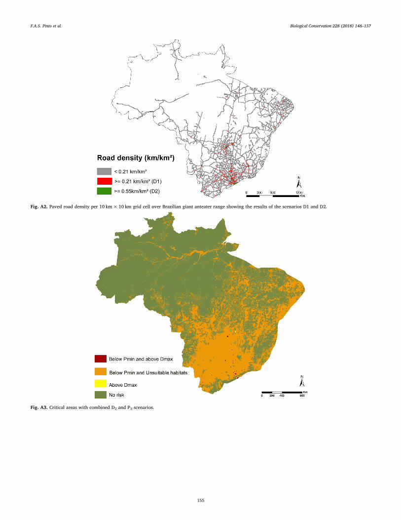
Fig. A2. Paved road density per 10 km× 10 km grid cell over Brazilian giant anteater range showing the results of the scenarios D1 and D2.
Fig. A3. Critical areas with combined D2 and P3 scenarios.
F.A.S. Pinto et al. %LRORJLFDO�&RQVHUYDWLRQ���������������²���
���
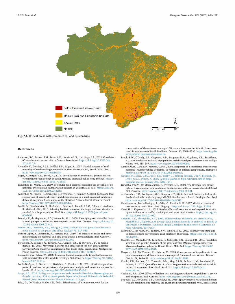
Fig. A4. Critical areas with combined D1 and P2 scenarios.
References
Anderson, S.C., Farmer, R.G., Ferretti, F., Houde, A.L.S., Hutchings, J.A., 2011. Correlatesof vertebrate extinction risk in Canada. Bioscience. https://doi.org/10.1525/bio.2011.61.7.8.
Ascensão, F., Desbiez, A.L.J., Médici, E.P., Bager, A., 2017. Spatial patterns of roadmortality of medium–large mammals in Mato Grosso do Sul, Brazil. Wildl. Res.https://doi.org/10.1071/WR16108.
Bager, A., Borghi, C.E., Secco, H., 2015. The influence of economics, politics and en-vironment on road ecology in South America. In: Handbook of Road Ecology, https://doi.org/10.1002/9781118568170.ch50.
Balkenhol, N., Waits, L.P., 2009. Molecular road ecology: exploring the potential of ge-netics for investigating transportation impacts on wildlife. Mol. Ecol. https://doi.org/10.1111/j.1365-294X.2009.04322.x.
Balkenhol, N., Pardini, R., Cornelius, C., Fernandes, F., Sommer, S., 2013. Landscape-levelcomparison of genetic diversity and differentiation in a small mammal inhabitingdifferent fragmented landscapes of the Brazilian Atlantic Forest. Conserv. Genet.https://doi.org/10.1007/s10592-013-0454-2.
Basille, M., Van Moorter, B., Herfindal, I., Martin, J., Linnell, J.D.C., Odden, J., Andersen,R., Gaillard, J.M., 2013. Selecting habitat to survive: the impact of road density onsurvival in a large carnivore. PLoS One. https://doi.org/10.1371/journal.pone.0065493.
Beaudry, F., de Maynadier, P.G., Hunter Jr., M.L., 2008. Identifying road mortality threatat multiple spatial scales for semi-aquatic turtles. Biol. Conserv. https://doi.org/10.1016/j.biocon.2008.07.016.
Bender, D.J., Contreras, T.A., Fahrig, L., 1998. Habitat loss and population decline: ameta-analysis of the patch size effect. Ecology 79, 517–533.
Benítez-López, A., Alkemade, R., Verweij, P.A., 2010. The impacts of roads and otherinfrastructure on mammal and bird populations: a meta-analysis. Biol. Conserv.https://doi.org/10.1016/j.biocon.2010.02.009.
Bertassoni, A., Mourão, G., Ribeiro, R.C., Cesário, C.S., de Oliveira, J.P., de CassiaBianchi, R., 2017. Movement patterns and space use of the first giant anteater(Myrmecophaga tridactyla) monitored in São Paulo State, Brazil. Stud. NeotropicalFauna Environ. https://doi.org/10.1080/01650521.2016.1272167.
Bissonette, J.A., Adair, W., 2008. Restoring habitat permeability to roaded landscapeswith isometrically-scaled wildlife crossings. Biol. Conserv. https://doi.org/10.1016/j.biocon.2007.10.019.
Borda-De-Água, L., Navarro, L., Gavinhos, C., Pereira, H.M., 2011. Spatio-temporal im-pacts of roads on the persistence of populations: analytic and numerical approaches.Landsc. Ecol. https://doi.org/10.1007/s10980-010-9546-2.
Braga, F.G., 2010. Ecologia e comportamento de tamanduá-bandeira Myrmecophaga tri-dactyla Linnaeus, 1758 no município de Jaguariaíva, Paraná. Universidade Federal doParaná (Tese. Doutorado em Ciências Florestais. 119 pp.).
Brito, D., De Viveiros Grelle, C.E., 2004. Effectiveness of a reserve network for the
conservation of the endemic marsupial Micoureus travassosi in Atlantic Forest rem-nants in southeastern Brazil. Biodivers. Conserv. 13, 2519–2536. https://doi.org/10.1023/B:BIOC.0000048450.85086.00.
Brook, B.W., O'Grady, J.J., Chapman, A.P., Burgman, M.A., Akçakaya, H.R., Frankham,R., 2000. Predictive accuracy of population viability analysis in conservation biology.Nature 404, 385–387. https://doi.org/10.1038/35006050.
Camilo-Alves, C.D.S.E.P., Mourão, G.D.M., 2006. Responses of a specialized insectivorousmammal (Myrmecophaga tridactyla) to variation in ambient temperature. Biotropica.https://doi.org/10.1111/j.1744-7429.2006.00106.x.
Cardillo, M., Mace, G.M., Jones, K.E., Bielby, J., Bininda-Emonds, O.R.P., Sechrest, W.,Orme, C.D.L., Purvis, A., 2005. Multiple causes of high extinction risk in largemammal species. Science 309, 1239–1241.
Carvalho, F.M.V., De Marco Junior, P., Ferreira, L.G., 2009. The Cerrado into-pieces:habitat fragmentation as a function of landscape use in the savannas of central Brazil.Biol. Conserv. https://doi.org/10.1016/j.biocon.2009.01.031.
de Carvalho, N.C., Bordignon, M.O., Shapiro, J.T., 2014. Fast and furious: a look at thedeath of animals on the highway MS-080, Southwestern Brazil. Iheringia. Sér. Zool.https://doi.org/10.1590/1678-4766201410414349.
Ceia-Hasse, A., Borda-De-Água, L., Grilo, C., Pereira, H.M., 2017. Global exposure ofcarnivores to roads. Glob. Ecol. Biogeogr. https://doi.org/10.1111/geb.12564.
Chen, H.L., Koprowski, J.L., 2016. Barrier effects of roads on an endangered forest ob-ligate: influences of traffic, road edges, and gaps. Biol. Conserv. https://doi.org/10.1016/j.biocon.2016.03.017.
Chiquito, E.A., Percequillo, A.R., 2009. Myrmecophaga tridactyla. In: Bressan, P.M.,Kierulff, M.C., Sugieda, A.M. (Orgs) (Eds.), Fauna ameaçada de extinção no Estado deSão Paulo: Vertebrados. Fundação Parque Zoológico de São Paulo e Secretaria doMeio Ambiente, São Paulo.
Ciocheti, G., de Assis, J.C., Ribeiro, J.W., Ribeiro, M.C., 2017. Highway widening andunderpass effects on vertebrate road mortality. Biotropica. https://doi.org/10.1111/btp.12480.
Clozato, C.L., Miranda, F.R., Lara-Ruiz, P., Collevatti, R.G., Santos, F.R., 2017. Populationstructure and genetic diversity of the giant anteater (Myrmecophaga tridactyla:Myrmecophagidae, pilosa) in Brazil. Genet. Mol. Biol. https://doi.org/10.1590/1678-4685-GMB-2016-0104.
Cosgrove, A.J., McWhorter, T.J., Maron, M., 2018. Consequences of impediments to an-imal movements at different scales: a conceptual framework and review. Divers.Distrib. 24, 448–459. https://doi.org/10.1111/ddi.12699.
Crooks, K.R., Burdett, C.L., Theobald, D.M., King, S.R.B., Di Marco, M., Rondinini, C.,Boitani, L., 2017. Quantification of habitat fragmentation reveals extinction risk interrestrial mammals. Proc. Natl. Acad. Sci. https://doi.org/10.1073/pnas.1705769114.
Cushman, S.A., 2006. Effects of habitat loss and fragmentation on amphibians: a reviewand prospectus. Biol. Conserv. https://doi.org/10.1016/j.biocon.2005.09.031.
de Souza, J.C., da Cunha, V.P., Markwith, S.H., 2015. Spatiotemporal variation in human-wildlife conflicts along highway BR-262 in the Brazilian Pantanal. Wetl. Ecol. Manag.
F.A.S. Pinto et al. %LRORJLFDO�&RQVHUYDWLRQ���������������²���
���
https://doi.org/10.1007/s11273-014-9372-4.Desbiez, A.L.J., Medri, Í.M., 2010. Density and Habitat Use by Giant Anteaters
(Myrmecophaga tridactyla) and Southern Tamanduas (Tamandua tetradactyla) in thePantanal Wetland, Brazil. 11. BioOne, pp. 4–10. https://doi.org/10.1896/020.011.0102.
Diniz, M.F., Brito, D., 2013. Threats to and viability of the giant anteater, Myrmecophagatridactyla (Pilosa: Myrmecophagidae), in a protected Cerrado remnant encroached byurban expansion in central Brazil. Zoology. https://doi.org/10.1590/S1984-46702013000200005.
Diniz, M.F., Brito, D., 2015. Protected areas effectiveness in maintaining viable giantanteater (Myrmecophaga tridactyla) populations in an agricultural frontier. Nat.Conserv. https://doi.org/10.1016/j.ncon.2015.08.001.
DNIT (Departamento Nacional de Infraenstrutura de Transporte), 2013. Sistema deGerencia de Pavimentos. Relatório dos levantamentos funcionais das rodovias fed-erais. Available on. www.dnit.gov.br.
Durigan, G., de Siqueira, M.F., Franco, G.A.D.C., 2007. Threats to the Cerrado remnants ofthe state of São Paulo, Brazil. Sci. Agric. https://doi.org/10.1590/S0103-90162007000400006.
Eduardo, A.A., Nunes, A.V., Brito, D., 2012. Do the protected areas network of the state ofminas gerais maintain viable populations of the lowland tapir (Tapirus terrestris).Nat. Conserv. https://doi.org/10.4322/natcon.2012.005.
Ferreras, P., Gaona, P., Palomares, F., Delibes, M., 2001. Restore habitat or reducemortality? Implications from a population viability analysis of the Iberian lynx. Anim.Conserv. 4, 265–274. https://doi.org/10.1017/S1367943001001317.
Fischer, W.A., 1997. Efeitos da rodovia BR-262 na mortalidade de vertebrados silvestres:Síntese naturalística para a conservação da região do Pantanal, MS. UniversidadeFederal do Mato Grosso do Sul, Campo Grande, MS (Dissertação de Mestrado, 38 pp.).
Freitas, C.H., Justino, C.S., Setz, E.Z.F., 2014. Road-kills of the giant anteater in south-eastern Brazil: 10 years monitoring spatial and temporal determinants. Wildl. Res.https://doi.org/10.1071/WR14220.
Geofabrik, 2016. OpenStreetMap-Shapefiles. Available at. http://download.geofabrik.de/, Accessed date: June 2016.
Gibbon, J.W., Scott, D.E., Ryan, T.J., Buhlmann, K.a., Tuberville, T.D., Metts, B.S.,Greene, J.L., Mills, T., Leiden, Y., Poppy, S., Winne, C.T., 2000. The global decline ofreptiles, Déjà Vu amphibians. Bioscience 50, 653–666. https://doi.org/10.1641/0006-3568(2000)050[0653:TGDORD]2.0.CO;2.
Gibbs, J.P., Shriver, W.G., 2002. Estimating the Effects of Road Mortality on TurtlePopulations. Conserv. Biol. 16, 1647–1652.
GLC (Global Land Cover Share), Lathan, John, Cumani, Renato, Rosati, Ilari, Bloise,Mario, 2014. Database Beta-release, Version 1.0.
Haddad, N.M., Brudvig, L.A., Clobert, J., Davies, K.F., Gonzalez, A., Holt, R.D., Lovejoy,T.E., Sexton, J.O., Austin, M.P., Collins, C.D., Cook, W.M., Damschen, E.I., Ewers,R.M., Foster, B.L., Jenkins, C.N., King, A.J., Laurance, W.F., Levey, D.J., Margules,C.R., Melbourne, B.A., Nicholls, A.O., Orrock, J.L., Song, D.-X., Townshend, J.R.,2015. Habitat fragmentation and its lasting impact on Earth's ecosystems. Sci. Adv.https://doi.org/10.1126/sciadv.1500052.
Haines, A.M., Tewes, M.E., Laack, L.L., Horne, J.S., Young, J.H., 2006. A habitat-basedpopulation viability analysis for ocelots (Leopardus pardalis) in the United States.Biol. Conserv. https://doi.org/10.1016/j.biocon.2006.04.035.
Herrmann, H.W., Pozarowski, K.M., Ochoa, A., Schuett, G.W., 2017. An interstatehighway affects gene flow in a top reptilian predator (Crotalus atrox) of the SonoranDesert. Conserv. Genet. https://doi.org/10.1007/s10592-017-0936-8.
IBGE, 2017. Brazilian Institute of Geography and Statistics. Available in. https://www.ibge.gov.br, Accessed date: October 2017.
IUCN, 2018. The IUCN Red List of Threatened Species. Version 2018-1. http://www.iucnredlist.org Downloaded on 05 March 2018.
IUCN (International Union for Conservation of Nature), 2014. Myrmecophaga tridactyla.In: The IUCN Red List of Threatened Species. Version 2017-3.
Jackson, N.D., Fahrig, L., 2011. Relative effects of road mortality and decreased con-nectivity on population genetic diversity. Biol. Conserv. https://doi.org/10.1016/j.biocon.2011.09.010.
Klink, C.A., Machado, R.B., 2005. Conservation of the Brazilian Cerrado. Conserv. Biol.https://doi.org/10.1111/j.1523-1739.2005.00702.x.
Laurance, W.F., Arrea, I.B., 2017. Roads to riches or ruin? Science 358 (6362), 442–444.https://doi.org/10.1126/science.aao0312.
Medici, E.P., Desbiez, A.L.J., 2012. Population viability analysis: using a modeling tool toassess the viability of tapir populations in fragmented landscapes. Integr. Zool.https://doi.org/10.1111/j.1749-4877.2012.00318.x.
Medri, I.M., 2002. Área de vida e uso do habitat de tamanduá-bandeira Myrmecophagatridactyla Linnaeus, 1758 nas Fazendas Nhumirim e Porto Alegre, Pantanal daNhecolândia, MS. Universidade Federal de Mato Grosso do Sul, Campo Grande(Dissertação. 83 pp. 2002).
Medri, I.M., Mourão, G., 2005. Home range of giant anteaters (Myrmecophaga tridactyla)in the Pantanal wetland, Brazil Home range of giant anteaters (Myrmecophaga tri-dactyla) in the Pantanal wetland, Brazií. J. Zool. 266, 365–375. https://doi.org/10.1017/S0952836905007004.
Miraldo, A., Sen, Li, Borregaard, M.K., Flórez-Rodriguez, A., Gopalakrishnan, S.,Rizvanovic, M., Wang, Z., Rahbek, C., Marske, K.A., Nogués-Bravo, D., 2016. Ananthropocene map of genetic diversity. Science 353 (6307), 1532–1535. https://doi.org/10.1126/science.aaf4381.
Miranda, G.H.B., 2004. Ecologia e conservação do tamanduá-bandeira (Myrmecophagatridactyla Linnaeus, 1758) no Parque Estadual das Emas. Universidade de Brasília(Tese. Doutorado em ecologia. 2004. 81 pp.).
Miranda, F., Bertassoni, A., Abba, A.M., 2014. Myrmecophaga tridactyla, Giant Anteater.Myrmecophaga tridactyla. In: IUCN Red List Threat. Species, https://doi.org/10.2305/IUCN.UK.2014.
Miranda, F.R., Chiarello, A.G., Röhe, F., Braga, F.G., Mourão, G.M., Miranda, G.H.B.,Silva, K.F.M., Faria-Corrêa, M.A., Vaz, S.M., Belentani, S.C.S., 2015. Avaliação doRisco de Extinção de Myrmecophaga tridactyla Linnaeus, 1758 no Brasil. Processo deavaliação do risco de extinção da fauna brasileira. ICMBio. http://www.icmbio.gov.br/portal/biodiversidade/fauna-brasileira/lista-de-especies/7049-mamiferos-myrmecophaga-tridactyla-tamandua-bandeira.htm.
Mourão, G., Medri, Í.M., 2007. Activity of a specialized insectivorous mammal(Myrmecophaga tridactyla) in the Pantanal of Brazil. J. Zool. 271, 187–192. https://doi.org/10.1111/j.1469-7998.2006.00198.x.
Mumme, R.L., Schoech, S.J., Woolfenden, G.E., Fitzpatrick, J.W., 2000. Life and death inthe fast lane: demographic consequences of road mortality in the Florida Scrub-Jay.Conserv. Biol. 14, 501–512. https://doi.org/10.1046/j.1523-1739.2000.98370.x.
Paviolo, A., De Angelo, C., Ferraz, K.M.P.M.B., Morato, R.G., Martinez Pardo, J., Srbek-Araujo, A.C., Beisiegel, B. de M., Lima, F., Sana, D., Xavier da Silva, M., Velázquez,M.C., Cullen, L., Crawshaw Jr., P., Jorge, M.L.S.P., Galetti, P.M., Di Bitetti, M.S., dePaula, R.C., Eizirik, E., Aide, T.M., Cruz, P., Perilli, M.L.L., Souza, A.S.M.C., Quiroga,V., Nakano, E., Ramírez Pinto, F., Fernández, S., Costa, S., Moraes Jr., E.A., Azevedo,F., 2016. A biodiversity hotspot losing its top predator: the challenge of jaguarconservation in the Atlantic Forest of South America. Sci. Rep. https://doi.org/10.1038/srep37147.
Pereira, H.M., Daily, G.C., 2006. Modeling biodiversity dynamics in countryside land-scapes. Ecology. https://doi.org/10.1016/B978-0-12-384719-5.00334-8.
Pereira, H.M., Leadley, P.W., Proenca, V., Alkemade, R., Scharlemann, J.P.W., Fernandez-Manjarres, J.F., Araujo, M.B., Balvanera, P., Biggs, R., Cheung, W.W.L., Chini, L.,Cooper, H.D., Gilman, E.L., Guenette, S., Hurtt, G.C., Huntington, H.P., Mace, G.M.,Oberdorff, T., Revenga, C., Rodrigues, P., Scholes, R.J., Sumaila, U.R., Walpole, M.,2010. Scenarios for global biodiversity in the 21st century. Science 330, 1496–1501.
Rands, M.R.W., Adams, W.M., Bennun, L., Butchart, S.H.M., Clements, A., Coomes, D.,Entwistle, A., Hodge, I., Kapos, V., Scharlemann, J.P.W., Sutherland, W.J., Vira, B.,2010. Biodiversity conservation: challenges beyond 2010. Science 329 (80),1298–1303. https://doi.org/10.1126/science.1189138.
Rodrigues, A.S.L., Andelman, S.J., Bakar, M.I., Boitani, L., Brooks, T.M., Cowling, R.M.,et al., 2004. Effectiveness of the global protected area network in representing speciesdiversity. Nature 428, 640–643.
Row, J.R., Blouin-Demers, G., Weatherhead, P.J., 2007. Demographic effects of roadmortality in black ratsnakes (Elaphe obsoleta). Biol. Conserv. 137, 117–124. https://doi.org/10.1016/j.biocon.2007.01.020.
Rytwinski, T., Fahrig, L., 2012. Do species life history traits explain population responsesto roads? A meta-analysis. Biol. Conserv. https://doi.org/10.1016/j.biocon.2011.11.023.
Schipper, J., et al., 2008. The status of the world's land and marine mammals: diversity,threat, and knowledge. Science 322, 225–230.
Schumaker, N.H., Brookes, A., Dunk, J.R., Woodbridge, B., Heinrichs, J.A., Lawler, J.J.,Carroll, C., Laplante, D., 2014. Mapping sources, sinks, and connectivity using a si-mulation model of northern spotted owls. Landsc. Ecol. 29, 579–592. https://doi.org/10.1007/s10980-014-0004-4.
Shaw, J.H., Machado-Neto, J., Carter, T.J., 1987. Behavior of free-living giant anteaters(Myrmecophaga tridactyla). Biotropica 19, 255–259.
Skellam, J.G., 1951. Random dispersal in theoretical populations. Biometrika 38 (1/2),196–218.
Strassburg, B.B.N., Brooks, T., Feltran-Barbieri, R., Iribarrem, A., Crouzeilles, R., Loyola,R., Latawiec, A.E., Oliveira Filho, F.J.B., De Scaramuzza, C.A.M., Scarano, F.R.,Soares-Filho, B., Balmford, A., 2017. Moment of truth for the Cerrado hotspot. Nat.Ecol. Evol. 1, 1–3. https://doi.org/10.1038/s41559-017-0099.
Teixeira, F., et al., 2016. The need to improve and integrate science and environmentallicensing to mitigate wildlife mortality on roads in Brazil. Trop. Conserv. Sci. 9,24–42.
Thiel, R.P., 1985. Relationship between road densities and wolf habitat suitability inWisconsin. Am. Midl. Nat. 113, 404–407.
Torres, A., Jaeger, J.A.G., Alonso, J.C., 2016. Assessing large-scale wildlife responses tohuman infrastructure development. Proc. Natl. Acad. Sci. 113, 8472–8477. https://doi.org/10.1073/pnas.1522488113.
Tucker, M.A., Böhning-Gaese, K., Fagan, W.F., Fryxell, J.M., Van Moorter, B., Alberts,S.C., Ali, A.H., Allen, A.M., Attias, N., Avgar, T., Bartlam-Brooks, H., Bayarbaatar, B.,Belant, J.L., Bertassoni, A., Beyer, D., Bidner, L., Van Beest, F.M., Blake, S., Blaum, N.,Bracis, C., Brown, D., De Bruyn, P.J.N., Cagnacci, F., Diefenbach, D., Douglas-Hamilton, I., Fennessy, J., Fichtel, C., Fiedler, W., Fischer, C., Fischhoff, I., Fleming,C.H., Ford, A.T., Fritz, S.A., Gehr, B., Goheen, J.R., Gurarie, E., Hebblewhite, M.,Heurich, M., Hewison, A.J.M., Hof, C., Hurme, E., Isbell, L.A., Janssen, R., Jeltsch, F.,Kaczensky, P., Kane, A., Kappeler, P.M., Kauffman, M., Kays, R., Kimuyu, D., Koch, F.,Kranstauber, B., Lapoint, S., Mattisson, J., Medici, E.P., Mellone, U., Merrill, E.,Morrison, T.A., Díaz-Muñoz, S.L., Mysterud, A., Nandintsetseg, D., Nathan, R.,Niamir, A., Odden, J., Hara, R.B.O., Oliveira-Santos, L.G.R., Olson, K.A., Patterson,B.D., De Paula, R.C., Pedrotti, L., Reineking, B., Rimmler, M., 2018. Moving in theAnthropocene: global reductions in terrestrial mammalian movements. Science 359(6374), 466–469. https://doi.org/10.1126/science.aam9712.
Van Dyke, F.G., Brocke, R.H., Shaw, H.G., Ackerman, B.B., Hemker, P., Lindzey, F.G.,1986. Lions to logging and of mountain reactions. Source. J. Wildl. Manag. 50,95–102 Allen Press.
Vynne, C., Keim, J.L., Machado, R.B., Marinho-Filho, J., Silveira, L., Groom, M.J., Wasser,S.K., 2011. Resource selection and its implications for wide-ranging mammals of theBrazilian Cerrado. PLoS One. https://doi.org/10.1371/journal.pone.0028939.
Zanin, M., Palomares, F., Brito, D., 2015. The jaguar's patches: viability of jaguar popu-lations in fragmented landscapes. J. Nat. Conserv. https://doi.org/10.1016/j.jnc.2014.06.003.
F.A.S. Pinto et al. %LRORJLFDO�&RQVHUYDWLRQ���������������²���
���