BIOLOGICAL ASSESSMENT UNIT BASINWIDE ASSESSMENT REPORT ... · BIOLOGICAL ASSESSMENT UNIT BASINWIDE...
25
BIOLOGICAL ASSESSMENT UNIT BASINWIDE ASSESSMENT REPORT SAVANNAH RIVER BASIN NORTH CAROLINA DEPARTMENT OF ENVIRONMENT AND NATURAL RESOURCES Division of Water Quality Environmental Sciences Section November 2010
-
Upload
hoangquynh -
Category
Documents
-
view
217 -
download
0
Transcript of BIOLOGICAL ASSESSMENT UNIT BASINWIDE ASSESSMENT REPORT ... · BIOLOGICAL ASSESSMENT UNIT BASINWIDE...

BIOLOGICAL ASSESSMENT UNIT BASINWIDE ASSESSMENT
REPORT
SAVANNAH RIVER BASIN
NORTH CAROLINA DEPARTMENT OF ENVIRONMENT
AND NATURAL RESOURCES Division of Water Quality
Environmental Sciences Section
November 2010

This page was intentionally left blank

TABLE OF CONTENTS Section Page INTRODUCTION TO PROGRAM METHODS .............................................................................................. 4
BASIN DESCRIPTION .................................................................................................................................. 4
SAVANNAH RIVER HU 03060101 – SENECA RIVER ................................................................................ 6
River and Stream Assessment .............................................................................................................. 6
Special Studies ...................................................................................................................................... 7
SAVANNAH RIVER HU 03060102 – TUGALOO RIVER ............................................................................. 8
River and Stream Assessment .............................................................................................................. 8
GLOSSARY ................................................................................................................................................ 10
LIST OF APPENDICES Appendix Page B-1. Summary of benthic macroinvertebrate data, sampling methods and criteria. ................................12 S-1. Benthic site summaries for basinwide sites collected in the Savannah River basin for the 2009
cycle. ................................................................................................................................................17
LIST OF TABLES Table Page Table 1. Waterbodies monitored in HU 03060101 in the Savannah River basin for basinwide
assessment, 2004 and 2009. .................................................................................................... 7
Table 2. Waterbodies monitored in HU 03060102 in the Savannah River basin for basinwide assessment, 2004 and 2009. .................................................................................................... 9
Table 3. Rare taxa collected in the Savannah River Basin. .................................................................. 13
Table 4. Benthic macroinvertebrate data collected from Savannah River Basin through 2009 ........... 15
LIST OF FIGURES Figure Page
Figure 1. Geographical relationships of the Savannah River basin. ........................................................ 5
Figure 2. Sampling sites in HUC 03060101 in the Savannah River basin. .............................................. 6
Figure 3. Sampling sites in HUC 03060102 in the Savannah River basin. .............................................. 8
Figure 4. Bioclassification trends in the Savannah River Basin: 1994-2009. ......................................... 12
3
INTRODUCTION TO PROGRAM METHODS The Environmental Sciences Section collects a variety of biological, chemical, and physical data that can be used in many ways to assist the basinwide planning program. This report addresses the results of benthic macroinvertebrate monitoring in the Savannah River for the period 2004-2009. The basin has been sampled by the Biological Assessment Unit (BAU) three times prior to this study for basinwide monitoring, in 1994, 1999, and 2004. Details of biological sampling methods (including habitat evaluation) and rating criteria can be found in the appendices of this report. Technical terms are defined in the Glossary. This document is structured with physical, geographical, and biological data discussions presented in hydrologic units (HUs). General water quality conditions are given in an upstream to downstream format. Lakes data, ambient chemistry data and aquatic toxicity data, with summaries, are presented in separate reports.
BASIN DESCRIPTION
The portion of the Savannah River Basin located in North Carolina lies almost entirely within the Southern Crystalline Ridges and Mountains ecoregion1 (a small portion of the Tallulah River catchment lies within the High Mountains ecoregion) and occupies 171 square miles. Much of the land (74 square miles) is contained within Nantahala National Forest—including Southern Nantahala Wilderness and Ellicott Rock Wilderness—and Gorges State Park. Southeast portions of Clay and Macon, southern Jackson, and southwestern Transylvania counties are included within the basin. The largest community wholly contained within the basin is Cashiers; southern and eastern portions of Highlands are also within the basin. Additional areas of commercial, residential, and golf course development can be found scattered throughout the US 64 corridor between Lake Toxaway and Highlands. Outstanding Resource Waters located in the basin include Big Creek and its tributaries, Overflow Creek and its tributaries, and the mainstem of Chattooga River. In addition, a portion of Horsepasture River downstream from NC 281 and most of the North Carolina portion of Chattooga River are included in the National Wild and Scenic River System. No 303(d)-listed waters exist in the basin. There are two 8-digit HUs in this basin: 03060101 (Seneca River), and 03060102 (Tugaloo River). Waters from the two HUs flow to Hartwell Lake (actually a reservoir) in Georgia, joining to form Savannah River. Eight benthic sites were sampled between the two HUs in 2009.
1 Griffith, G.E., Omernik, J.M., Comstock, J.A. Schafale, M.P., McNab, W.H., Lenat, D.R., MacPherson, T.F., Glover, J.B. and Shelburne, V.B. 2002. Ecoregions of North Carolina and South Carolina. (color poster with map, descriptive text, summary tables and photographs): Reston, VA, U.S. Geological Survey (map scale 1:1,500,000).
4

Figure 1. Geographical relationships of the Savannah River basin.
5

SAVANNAH RIVER HU 03060101 – SENECA RIVER
Figure 2. Sampling sites in HU 03060101 in the Savannah River basin. Monitoring sites are
listed in Table 1.
River and Stream Assessment Specific summaries of the four benthic macroinvertebrate basinwide sampling events may be found in Appendix S-1. Four basinwide collections were made in August 2009 in the HU (Table 1). Two sites were rated as Excellent, one as Good, and one (Thompson River at NC 281) was assigned a classification of Not Impaired. The drainage area above the Thompson River site is 2.5 square miles (which puts the site into the small-stream category) and has always been collected outside of the seasonal window for use of small stream criteria for assessment, therefore all prior classifications for the site have been changed to Not Impaired as well. Classifications did not change at any of the sites between the basinwide sampling events in 2004 and those in 2009.
6

Table 1. Waterbodies monitored in HU 03060101 in the Savannah River basin for basinwide
assessment, 2004 and 2009.
SiteID Waterbody County Location 2004 2009 HB1 Indian Cr Transylvania US 64 Excellent Excellent HB2 Horsepasture R Transylvania NC 281 Good Good HB8 Whitewater R Transylvania NC 281 Excellent Excellent HB4 Thompson R Transylvania NC 281 Not Impaired* Not Impaired
* Reported as “Excellent” in the prior basinwide report.
Special Studies 2006 ORW Reclassification Study for the Horsepasture River Drainage To assess the biological condition of the Horsepasture River drainage to consider Outstanding Resource Waters (ORW) protection, eleven sites were selected for benthic sampling within the drainage.2 Six were small-stream sites; of those, two were assigned a classification of Not Rated, the remaining four were Not Impaired. At the time these streams were sampled no criteria existed for evaluating small-stream sites with disturbance within the drainage. Such small-stream sites receive a classification of “Not Impaired” if they would attain a classification of Excellent, Good, or Good-Fair using EPT criteria, or “Not Rated” otherwise. Two of the large-stream sites received a classification of Good-Fair, and two other sites were Good. Only the site on lowermost segment of the mainstem of Horsepasture River (AU designation 4-13-(12.5)) received an Excellent. Based upon that result, the state designation of Natural and Scenic River, and the federal designation of National Wild and Scenic River, the stream segment was recommended for the additional classification of Outstanding Resource Waters.
2 Ausley, L. 2006. Horsepasture River Drainage Use Attainability Request Benthic Macroinvertebrate Special Study, Horsepasture River Watershed, Savannah River Subbasin 02, Jackson and Transylvania Counties, June 2006. Internal, unpublished BAU memorandum dated 1 November 2006.
7

SAVANNAH RIVER HU 03060102 – TUGALOO RIVER
Figure 3. Sampling sites in HU 03060102 in the Savannah River basin. Monitoring sites are
listed in Table 2.
River and Stream Assessment Specific summaries of the four benthic macroinvertebrate basinwide sampling events may be found in Appendix S-1. There have been no special studies in the HU since the prior basinwide cycle. Four basinwide collections were made in August 2009 in the HU (Table 2). All received classifications of Excellent. The basinwide site on Norton Mill Creek was not sampled in 2009 due to beaver activity, both upstream and downstream of the road crossing, which greatly reduced normal streamflow and velocity at the site. The Tallulah River catchment was sampled for the first time by the BAU in 2009; the site will be added to the list of basinwide sites for the HU.
8

9
Table 2. Waterbodies monitored in HU 03060102 in the Savannah River basin for basinwide assessment, 2004 and 2009.
Site ID Waterbody County Location 2004 2009
HB6 Chattooga R Jackson SR 1107 Excellent Excellent HB9 Chattooga R Jackson SR 1100 Excellent Excellent
HB14 Big Cr Macon SR 1608 Excellent Excellent HB42 Tallulah R Clay off Tate City Rd --- Excellent

GLOSSARY
Assessment Unit A stream or a segment of a stream. Assessment Unit designations are used to uniquely identify streams or stream segments for the purpose of classifying waters for protection by use (such as for drinking water supply or trout waters).
BI or NCBI North Carolina Biotic Index. This is one of two metrics used extensively to
evaluate the results of benthic sampling, and is the weighted sum of tolerance values for taxa found in the sample relative to their abundance.
Bioclassification A classification assigned to a stream site following biological sampling of either
fish or macroinvertebrates. Criteria have been developed to assign bioclassifications ranging from Poor to Excellent to each sample. For invertebrates the bioclassification is based on the number of taxa present in the intolerant groups (EPT) and the North Carolina Biotic Index (BI or NCBI) value. For fish the classification is based on abundance, condition of specimens, species richness, composition, pollution-tolerance, trophic composition, and reproductive function.
Ecoregion An area of relatively homogeneous environmental conditions, usually defined by
elevation, geology, vegetation, and soil type. Examples include Mountains, Piedmont, Coastal Plain, Sand Hills, and Carolina Slate Belt.
EPT The insect orders Ephemeroptera, Plecoptera, and Trichoptera. As a whole,
these are the most intolerant insects present in the benthic community. EPT also refers to taxa richness within the three insect orders, a metric used extensively to derive bioclassifications. Higher EPT taxa richness values are associated with better water quality.
EPT BI North Carolina Biotic Index for the EPT portion of the benthic community. This is
the weighted sum of the tolerance values of taxa in the insect orders Ephemeroptera, Plecoptera, and Trichoptera found in the sample, relative to their abundance.
HQW High Quality Waters. Such waters are rated Excellent based on biological and
physical/chemical characteristics through Division monitoring or special studies and have been approved for such designation by the state Environmental Management Commission; also, primary nursery areas designated by the Marine Fisheries Commission, and all Class SA waters.
MGD Million gallons per day. This is generally the unit in which effluent discharge flow
is measured. NPDES National Pollutant Discharge Elimination System. NCIBI North Carolina Index of Biotic Integrity (NCIBI); a summary measure of the
effects of factors influencing the fish community. ORW Outstanding Resource Waters. These are unique and special waters of
exceptional state or national recreational or ecological significance that require special protection to maintain existing uses and have been approved for such designation by the Environmental Management Commission.
10

11
GLOSSARY (continued)
Specific Conductance The measure of the resistance of a solution to electrical flow. Resistance is
reduced with increasing content of ionized salts. Reported in the units of μmhos/cm at 25 oC.
ST Total invertebrate richness. The total number of different taxa present in a Full
Scale benthic macroinvertebrate sample. UT Unnamed tributary. WTP Water treatment plant. WWTP Wastewater treatment plant

Appendix B-1. Summary of benthic macroinvertebrate data, sampling methods and criteria.
Savannah River Basin Summary For 2009, eight long-term benthic macroinvertebrate samples were collected in the Savannah River Basin as part of the Basinwide Assessment program. Graphical representations of bioclassification trends from 2009-1994 among these long-term basinwide benthos stations can be found in Figure 4. As can be seen from these data, the 2009 benthic macroinvertebrate community bioclassifications have generally remained unchanged since 1994. The primary change in this basin from 1994 to 2009 is mainly due to the additional of new basinsites each year from a low of five in 1994 to eight in 2009. The excellent and stable water quality found throughout most of this basin is primarily a function of the mostly forested landuse coupled with a generally sparse population and lack of any large-scale agriculture.
0 2 4 6 8
1994
1999
2004
2009
2
1
1
1
3
5
6
7
Number of Samples
ExcellentGoodGood-FairFairPoor
Figure 4. Bioclassification trends in the Savannah River Basin (HU 03060101 and HU 03060102):
1994-2009.
12

Numerous rare invertebrate taxa were collected in the Savannah River basin in 2009. These data are presented below in Table 3. Table 3. Rare taxa collected in the Savannah River Basin (rare taxa are defined as those taxa
which occur less than or equal to 0.5% of approximately 6,500 NCDWQ benthic collections).
CC Num Sample Type Date Waterbody Location County Subbasin HU Scientific Name 10825 EPT 8/20/09 TALLULAH R OFF TATE CITY RD Clay 1 03060102 GOERA FUSCULA 10825 EPT 8/20/09 TALLULAH R OFF TATE CITY RD Clay 1 03060102 CERATOPSYCHE SPP 10825 EPT 8/20/09 TALLULAH R OFF TATE CITY RD Clay 1 03060102 EPEORUS SUBPALLIDUS 10825 EPT 8/20/09 TALLULAH R OFF TATE CITY RD Clay 1 03060102 HANSONOPERLA APPALACHIA 10823 Full Scale 8/19/09 CHATTOOGA R SR 1100 JACKSON 1 03060102 NANOCLADIUS BRANCHICOLUS 10822 EPT 8/19/09 CHATTOOGA R SR 1107 JACKSON 1 03060102 HEXAGENIA LIMBATA 10823 Full Scale 8/19/09 CHATTOOGA R SR 1100 JACKSON 1 03060102 OPTIOSERVUS TRIVITTATUS 10823 Full Scale 8/19/09 CHATTOOGA R SR 1100 JACKSON 1 03060102 PARATANYTARSUS LONGISTYLUS10823 Full Scale 8/19/09 CHATTOOGA R SR 1100 JACKSON 1 03060102 EUKIEFFERIELLA TIROLENSIS 10823 Full Scale 8/19/09 CHATTOOGA R SR 1100 JACKSON 1 03060102 DEMICRYPTOCHIRONOMUS SP B 10823 Full Scale 8/19/09 CHATTOOGA R SR 1100 JACKSON 1 03060102 CRICOTOPUS NOSTOCICOLA 10823 Full Scale 8/19/09 CHATTOOGA R SR 1100 JACKSON 1 03060102 MICROPSECTRA SP A
10820 Full Scale 8/18/09 HORSEPASTURE R NC 281 TRANSYLVANIA 2 03060101 PARACLADOPELMA SP 1
10820 Full Scale 8/18/09 HORSEPASTURE R NC 281 TRANSYLVANIA 2 03060101 TANYTARSUS SP Y
10820 Full Scale 8/18/09 HORSEPASTURE R NC 281 TRANSYLVANIA 2 03060101 EPEORUS SUBPALLIDUS
10820 Full Scale 8/18/09 HORSEPASTURE R NC 281 TRANSYLVANIA 2 03060101 TANYTARSUS SP M
10820 Full Scale 8/18/09 HORSEPASTURE R NC 281 TRANSYLVANIA 2 03060101 DJALMABATISTA PULCHRA
10819 EPT 8/18/09 WHITEWATER R NC 281 TRANSYLVANIA 2 03060101 HELICOPSYCHE PARALIMNELLA
13

14
Sampling Methods
Benthic macroinvertebrates can be collected from wadeable, freshwater, flowing streams and rivers using several sampling procedures, two of which are used for basinwide sampling in the mountainous region of western North Carolina. Standard Qualitative (Full Scale) Method The Biological Assessment Unit's standard qualitative (Full Scale) sampling procedure comprises 10 components: two kick-net collections, three sweeps, two rock or log washes, one sand collection, one leaf-pack collection, and visual collections from large rocks and logs.3 Invertebrates are removed from the matrix (“picked”) on-site. The purpose of these collections is to inventory the aquatic fauna and produce an indication of relative abundance for each taxon. Organisms are classified as Rare (1 - 2 specimens), Common (3 - 9 specimens), or Abundant (≥ 10 specimens). EPT Method Benthic macroinvertebrates can also be collected using the EPT sampling procedure. Four, rather than 10, composite qualitative samples are taken at each site: one kick, one sweep, one leaf-pack, and visual collections (NCDENR 2006). Only EPT taxa are collected and identified and only EPT taxa richness is used to assign a bioclassification.
Habitat Evaluation An assessment form has been developed by the Biological Assessment Unit to evaluate the physical habitat of a stream. The habitat score, which ranges between 1 and 100, is based on the qualitative evaluation of channel modification, amount of instream habitat, type of bottom substrate, pool variety, bank stability, light penetration, and riparian zone width. Higher numbers suggest better habitat quality, but no criteria have been developed to assign impairment ratings.
Data Analysis Bioclassifications for the Full Scale assessment method are based on EPT Richness and North Carolina Biotic Index (NCBI, sometimes just identified as BI) values. Both tolerance values for individual taxa and community biotic index values have a range of zero through 10, with higher numbers indicating more tolerant taxa and more polluted conditions respectively. NCBI scores are averaged with EPT taxa richness scores to produce a final bioclassification. Bioclassifications for the EPT sample method are based on the total number of EPT taxa present in the sample. EPT abundance and overall taxa richness can also be used to help examine between-site differences in water quality. EPT Richness and BI values are affected by seasonal changes. DWQ criteria for assigning bioclassifications are based on summer sampling, which occurs from June through September. For samples collected outside the summer sampling period, EPT Richness is often adjusted by removing the number of winter/spring Plecoptera taxa present to give a seasonally corrected value. Adjustments for seasonality may also be performed based upon site-specific differences between summer and non-summer samples if such data are available. The BI values also are seasonally adjusted for samples outside the summer season. No criteria are in place for small-stream samples collected from sites with a drainage area less than or equal to 3.0 square miles that are subject to anthropogenic disturbance and collected outside of the April to June seasonal window. Such sites are assigned a “Not Impaired” if they would earn a classification of either Excellent, Good, or Good-Fair using EPT criteria for larger stream sites, and a “Not Rated” otherwise.
3 NC DWQ. 2006. Standard Operating Procedures for Benthic Macroinvertebrates. North Carolina Department of Environment and Natural Resources, Division of Water Quality, Biological Assessment Unit. July 2006. Unpublished. http://www.esb.enr.state.nc.us/BAUwww/benthossop.pdf

15
Table 4. Benthic macroinvertebrate data collected from Savannah River Basin through 2009. Basinwide sites sampled in 2009 are in bold font.
HU/Waterbody Location County SiteID Date ST EPT BI EPTBI BioClass
03060101 Seneca River Bearwallow Cr FS Road lowest road crossing Transylvania HB13 05/08/91 ‐‐‐ 44 ‐‐‐ 1.67 Excellent 06/08/88 93 45 3.43 2.60 Excellent Bearwallow Cr FS Road nr Hogback Valley Transylvania HB36 09/13/89 ‐‐‐ 25 ‐‐‐ 2.00 Good‐Fair Bearwallow Cr Gorges State Park Transylvania HB5 07/20/04 ‐‐‐ 41 ‐‐‐ 2.47 Excellent Burlingame Cr SR 1152 Transylvania HB15 06/14/06 30 5 6.12 4.16 Not Rated Hogback Cr US 64 Jackson HB20 06/15/06 29 9 3.78 2.95 Not Rated Horsepasture R above Logan Cr Jackson HB23 06/12/06 72 26 5.18 3.68 Good‐Fair Horsepasture R above Windy Falls Transylvania HB22 06/15/06 100 51 4.00 2.73 Excellent Horsepasture R below Trays Island Cr Jackson HB21 06/13/06 ‐‐‐ 20 ‐‐‐ 4.43 Good‐Fair Horsepasture R NC 281 Transylvania HB2 08/18/09 103 38 4.29 2.76 Good 06/14/06 96 39 4.30 2.83 Good 07/19/04 98 41 4.15 2.91 Good 07/19/99 76 43 3.93 3.22 Excellent 07/25/94 89 36 4.35 3.06 Good 07/25/89 53 24 4.71 3.12 Good‐Fair 08/04/87 78 28 4.68 3.21 Good 07/21/86 92 36 4.48 2.92 Good 08/06/85 53 16 5.32 3.59 Fair 08/20/84 61 25 4.37 3.18 Good‐Fair Horsepasture R SR 1152 Transylvania HB24 06/14/06 82 32 4.75 3.06 Good Indian Cr US 64 Transylvania HB1 08/17/09 ‐‐‐ 39 ‐‐‐ 2.63 Excellent 07/20/04 ‐‐‐ 40 ‐‐‐ 2.22 Excellent 07/19/99 ‐‐‐ 34 ‐‐‐ 2.06 Good 07/25/94 ‐‐‐ 31 ‐‐‐ 1.96 Good L Hogback Cr US 64 Jackson HB25 06/13/06 48 28 4.54 3.72 Not Impaired Logan Cr US 64 Jackson HB26 06/12/06 77 45 3.34 2.22 Not Impaired Rock Cr US 64 Transylvania HB28 06/15/06 43 25 4.32 3.61 Not Impaired Thompson R downstream of NC 281 Transylvania HB40 09/12/89 74 29 5.56 3.55 Good‐Fair 02/24/88 79 38 4.60 2.62 Good‐Fair Thompson R NC 281 Transylvania HB4 08/18/09 ‐‐‐ 48 ‐‐‐ 2.16 Not Impaired 07/19/04 ‐‐‐ 46 ‐‐‐ 2.00 Not Impaired 09/12/89 84 43 3.17 2.17 Not Impaired 02/23/88 68 41 2.95 1.81 Not Impaired Thompson R NC‐SC state line Transylvania HB38 02/24/88 85 41 3.29 1.91 Good Toxaway R Gorges State Park Transylvania HB3 07/20/04 ‐‐‐ 36 ‐‐‐ 2.71 Excellent Trays Is Cr US 64 Jackson HB31 12/10/91 ‐‐‐ 31 ‐‐‐ 1.45 Excellent Trays Island Cr above Camp Merrie Woode Jackson HB30 06/13/06 58 36 2.45 2.14 Not Impaired UT Bearwallow Cr off US 64 downstream site Transylvania HB32 10/01/01 41 20 2.97 1.73 Not Impaired UT Bearwallow Cr off US 64 upstream site Transylvania HB39 10/01/01 29 19 2.16 1.23 Not Impaired UT Thompson R NC 281 Transylvania HB33 02/24/88 ‐‐‐ 31 ‐‐‐ 1.94 Good Whitewater R NC 281 Transylvania HB8 08/18/09 ‐‐‐ 49 ‐‐‐ 2.75 Excellent 07/19/04 ‐‐‐ 46 ‐‐‐ 2.31 Excellent 07/19/99 ‐‐‐ 48 ‐‐‐ 2.16 Excellent 07/25/94 ‐‐‐ 47 ‐‐‐ 1.95 Excellent

16
Table 6. —continued— HU/Waterbody Location County SiteID Date ST EPT BI EPTBI BioClass
03060102 Tugaloo River ‐‐‐ ‐‐‐ Abes Cr near Little Scaly Macon HB10 06/24/99 ‐‐‐ 28 ‐‐‐ 1.14 Not Impaired Big Cr off SR 1608 above Little Cr Macon HB37 07/18/99 ‐‐‐ 45 ‐‐‐ 1.86 Excellent 07/25/94 ‐‐‐ 45 ‐‐‐ 1.97 Excellent 01/20/88 ‐‐‐ 38 ‐‐‐ 2.29 Excellent 08/05/87 102 47 3.17 2.05 Excellent Big Cr SR 1608 above Norton Br Macon HB14 08/19/09 ‐‐‐ 42 ‐‐‐ 2.74 Excellent 07/21/04 ‐‐‐ 45 ‐‐‐ 2.47 Excellent 08/05/87 99 49 3.17 2.18 Excellent Chattooga R above Cashiers WWTP Jackson HB11 11/06/01 40 19 4.28 3.72 Not Impaired Chattooga R below Cashiers WWTP Jackson HB12 11/06/01 31 9 6.08 5.11 Not Rated Chattooga R SR 1100 Jackson HB9 08/19/09 118 51 3.86 2.44 Excellent 07/20/04 124 64 3.60 2.80 Excellent 07/18/99 107 57 3.29 2.76 Excellent 07/26/94 94 47 3.90 2.73 Excellent 08/07/90 92 44 3.44 2.43 Excellent 08/09/88 114 50 3.97 2.42 Excellent 01/19/88 83 45 3.17 2.47 Excellent Chattooga R SR 1107 Jackson HB6 08/19/09 ‐‐‐ 47 ‐‐‐ 2.58 Excellent 07/20/04 ‐‐‐ 48 ‐‐‐ 2.21 Excellent 01/18/88 96 48 3.63 2.96 Excellent Clear Cr SR 1618 Macon HB16 06/23/99 82 44 3.93 3.13 Excellent 01/21/88 ‐‐‐ 34 ‐‐‐ 3.58 Good E Fk Chattooga R NC 107 Jackson HB17 01/19/88 ‐‐‐ 31 ‐‐‐ 2.16 Good Fowler Cr SR 1100 Jackson HB19 01/19/88 64 37 3.38 2.47 Good Fowler Cr SR 1107 Jackson HB18 06/23/99 98 50 3.82 2.78 Excellent 01/18/88 ‐‐‐ 34 ‐‐‐ 3.19 Good Norton Mill Cr SR 1107 Jackson HB7 07/21/04 108 40 4.24 2.69 Good 06/23/99 71 44 3.58 2.86 Excellent 01/18/88 ‐‐‐ 19 ‐‐‐ 2.95 Good‐Fair Overflow Cr FS Road Macon HB27 07/10/91 68 42 2.55 2.06 Excellent 07/25/89 78 44 3.02 2.25 Excellent 01/21/88 ‐‐‐ 43 ‐‐‐ 2.17 Excellent Scotsman Cr SR 1100 Jackson HB29 06/23/99 ‐‐‐ 46 ‐‐‐ 1.95 Excellent 01/19/88 ‐‐‐ 42 ‐‐‐ 2.12 Excellent Tallulah R off Tate City Rd Clay HB42 08/20/09 ‐‐‐ 48 ‐‐‐ 1.93 Excellent UT W Fk Overflow Cr FS Road Macon HB34 01/20/88 ‐‐‐ 35 ‐‐‐ 1.80 Excellent W Fk Overflow Cr FS Road Macon HB35 01/20/88 68 46 2.50 1.96 Excellent

Appendix S-1. Benthic site summaries for basinwide sites collected in the Savannah River basin for the 2009 cycle.
17

Water Quality ParametersTemperature (°C) 18.7Dissolved Oxygen (mg/L) 8.0Specific Conductance (µS/cm) 20pH (s.u.) 6.0
Channel Modification (5) 5Instream Habitat (20) 16Bottom Substrate (15) 13Pool Variety (10) 10
Site Photograph
Water Clarity slightly turbid
Habitat Assessment Scores (max)
Upstream NPDES Dischargers (>1MGD or <1MGD and within 1 mile) NPDES Number Volume (MGD)none --- ---
Forested/Wetland Urban Agriculture Other (describe)Visible Landuse (%) 100 0 0 0
Stream Classification Drainage Area (mi2) Elevation (ft) Stream Width (m) Stream Depth (m)C;Tr 4.1 2730 4 0.3
AU Number Level IV EcoregionTRANSYLVANIA 2 03060101 35.126667 -82.914722 4-5-(3) Southern Crystalline Ridges and Mountains
County Subbasin 8 digit HUC Latitude Longitude
BENTHIC MACROINVERTEBRATE SAMPLE
Waterbody Location Station ID Date Bioclassification
INDIAN CR US 64 HB1 08/17/09 Excellent
Pool Variety (10) 10Riffle Habitat (16) 14Bank Erosion (7) 6Bank Vegetation (7) 6Light Penetration (10) 10Left Riparian Score (5) 5Right Riparian Score (5) 5Total Habitat Score (100) 90
Taxonomic AnalysisA few new taxa were identified for the first time from the site in 2009, including: Diphetor hageni, Serratella serrata, Litobrancha recurvata, Eccoptura xanthenes, Triaenodes ignitus, and Lype diversa . Two taxa which had been collected during each prior sampling event were not recorded for 2009: Baetis pluto and Perlesta . Differences in the number of Trichoptera identified from the site has been driving differences in EPT richness for three most recent sampling events. Trichoptera richness is 10, 16, and 14 taxa for 1999, 2004, and 2009 respectively.
Data AnalysisThe site is five miles west of Rosman and 1.9 stream-miles above the confluence with Toxaway River.
The site has supported a diverse EPT community, particularly observed with the two most recent sampling events in 2004 and 2009. The increasing EPT BI with each sampling event might be cause for concern; low levels of nutrient enrichment or small increases in the presence of fine sediments can be reflected by increasing diversity and biotic index values.
Good07/25/94 6596 --- 31 --- 1.96
Excellent07/19/99 7907 --- 34 --- 2.06 Good07/20/04 9416 --- 40 --- 2.22
Bioclassification08/17/09 10817 --- 39 --- 2.63 Excellent
Sample Date Sample ID ST EPT BI EPT BI
Substrate even mix of cobble, gravel, sand; some silt present

BENTHIC MACROINVERTEBRATE SAMPLE
Waterbody Location Station ID Date Bioclassification
HORSEPASTURE R NC 281 HB2 08/18/09 Good
County Subbasin 8 digit HUC Latitude Longitude AU Number Level IV EcoregionTRANSYLVANIA 2 03060101 35.092222 -82.975833 4-13-(0.5)b Southern Crystalline Ridges and Mountains
Stream Classification Drainage Area (mi2) Elevation (ft) Stream Width (m) Stream Depth (m)C;Tr 24 2860 18 0.4
Forested/Wetland Urban Agriculture Other (describe)Visible Landuse (%) 100 0 0 0
Upstream NPDES Dischargers (>1MGD or <1MGD and within 1 mile) NPDES Number Volume (MGD)none --- ---
Water Quality Parameters Site Photograph Temperature (°C) 21.7Dissolved Oxygen (mg/L) 7.8Specific t S/cm) Conduc ance (µ 24pH (s.u.) 6.1
Water Clarity clear
Habitat Assessment Scores (max)Channel M icatiodif on (5) 4Instream at Habit (20) 19( )Bottom tr Subs ate (15) 12Pool Variety (10) 9Riffl ate Habit (16) 15Bank Erosion (7) 5Bank Vegetation (7) 7Light P ienetrat on (10) 6Left c Riparian S ore (5) 5Right c Riparian S ore (5) 5Total i cor Hab tat S e (100) 87 Substrate mostly cobble/gravel with some boulder and sand
Sample Date Sample ID ST EPT BI EPT BI Bioclassification08/18/09 10820 103 38 4.29 2.76 Good06/14/06 9934 96 39 4.30 2.83 Good07/19/04 9412 98 41 4.15 2.91 Good07/19/99 7908 76 43 3.93 3.22 Excellent07/25/94 6597 89 36 4.35 3.06 Good07/25/89 5025 53 24 4.71 3.12 Good-Fair
Taxonomic AnalysisRhyacophila nigrita , a free-living caddisfly, was recorded from the site for the first time in 2009, as were the midges Chironomus, Djalmabatista pulchra, Lopescladius, and Pseudochironomus.
Data AnalysisThe site is about 10 miles east of Highlands, 5.5 stream-miles upstream of the South Carolina border, and directly downstream of the LBM Industries rock quarry. The site was sampled each summer from 1984 through 1987, then every five years from 1989. A sample was collected at the site in 2006 as part of a reclassification study.
Since 1989 both BI values and EPT Richness indicate an improving benthic community up to 1999 and a relatively stable community with successive sampling events since that year.

BENTHIC MACROINVERTEBRATE SAMPLE
Waterbody Location Station ID Date Bioclassification
WHITEWATER R NC 281 HB8 08/18/09 Excellent
County Subbasin 8 digit HUC Latitude Longitude AU Number Level IV EcoregionTRANSYLVANIA 2 03060101 35.037500 -83.022222 4-14-(1.5) Southern Crystalline Ridges and Mountains
Stream Classification Drainage Area (mi2) Elevation (ft) Stream Width (m) Stream Depth (m)C;Tr,HQW 12 2660 17 0.3
Forested/Wetland Urban Agriculture Other (describe)Visible Landuse (%) 100 0 0 0
Upstream NPDES Dischargers (>1MGD or <1MGD and within 1 mile) NPDES Number Volume (MGD)none --- ---
Water Quality Parameters Site Photograph Temperature (°C) 18.0Dissolved Oxygen (mg/L) 8.5Specific t S/cm) Conduc ance (µ 14pH (s.u.) 5.9
Water Clarity clear
Habitat Assessment Scores (max)Channel M icatiodif on (5) 4( )Instream at Habit (20) 18Bottom tr Subs ate (15) 13Pool Variety (10) 5Riffl ate Habit (16) 14Bank Erosion (7) 7Bank Vegetation (7) 7Light P ienetrat on (10) 5Left c Riparian S ore (5) 5Right c Riparian S ore (5) 5Total i cor Hab tat S e (100) 83 Substrate mostly boulder and cobble; moderate gravel, sand also present
Sample Date Sample ID ST EPT BI EPT BI Bioclassification08/18/09 10819 --- 49 --- 2.75 Excellent07/19/04 9411 --- 46 --- 2.31 Excellent07/19/99 7909 --- 48 --- 2.16 Excellent07/25/94 6598 --- 47 --- 1.95 Excellent
Taxonomic AnalysisSeveral taxa were identified from the site for the first time in 2009, including: Heterocloeon amplum, Micrasema rickeri, Helicopsyche paralimnella, Mystacides, and Molanna . The stonefly Perlesta was not collected from the site for the first time in 2009; specimens of the genus are most often collected May through July, so seasonality is likely a factor in its absence from the 2009 collection.
Data AnalysisThe site is about 10 miles east of Highlands and about 1.1 stream-miles north of the border with South Carolina.
EPT richness has been rather stable at the site for the four sampling events. As with the basinwide site on Indian Creek, this site has shown increasing EPT BI values with successive sampling events. The high EPT richness combined with increasing EPT BI values is suggestive of nutrient enrichment upstream of the site.

Water Quality ParametersTemperature (°C) 18.2Dissolved Oxygen (mg/L) 7.9Specific Conductance (µS/cm) 10pH (s.u.) 5.5
Channel Modification (5) 5Instream Habitat (20) 14Bottom S bstrate (15) 12
Bioclassification
THOMPSON R NC 281 HB4 08/18/09 Excellent
BENTHIC MACROINVERTEBRATE SAMPLE
Waterbody Location Station ID Date
AU Number Level IV EcoregionTRANSYLVANIA 2 03060101 35.077222 -82.998889 4-14-6 Southern Crystalline Ridges and Mountains
County Subbasin 8 digit HUC Latitude Longitude
C;Tr 2.5 2880 6 0.3Stream Classification Drainage Area (mi2) Elevation (ft) Stream Width (m) Stream Depth (m)
Forested/Wetland Urban Agriculture Other (describe)Visible Landuse (%) 100 0 0 0
Upstream NPDES Dischargers (>1MGD or <1MGD and within 1 mile) NPDES Number Volume (MGD)none --- ---
Site Photograph
Water Clarity clear
Habitat Assessment Scores (max)
Bottom Substrate (15) 12Pool Variety (10) 10Riffle Habitat (16) 11Bank Erosion (7) 7Bank Vegetation (7) 6Light Penetration (10) 8Left Riparian Score (5) 5Right Riparian Score (5) 5Total Habitat Score (100) 83 Substrate mostly bedrock, cobble, sand; also boulder, gravel, silt present
Bioclassification08/18/09 10821 --- 48 --- 2.16 Not Impaired
Sample Date Sample ID ST EPT BI EPT BI
Not Impaired09/12/89 5072 84 43 3.17 2.17 Not Impaired07/19/04 9413 --- 46 --- 2.00
Taxonomic AnalysisMany taxa were recorded for the first time from the site in 2009, and included: the mayflies Diphetor hageni, Baetisca, Serratella serrata, Epeorus vitreus, Maccaffertium meririvulanum, Rhithrogena ; the caddisflies Cheumatopsyche, Hydropsyche betteni, Chimarra, and Oligostomis pardalis .
Data AnalysisThe site is about 10 miles east of Highlands, and about four stream-miles upstream of the border with South Carolina. For stream sites with a drainage area of under 3 square miles, regular biological classifications can not be assigned except by using either High-Quality Small Mountain Stream or the more general small streams criteria; due to the small amount of potential disturbance in the watershed, sampling methods used, and seasons collected, the collections thus far from the site cannot be classified.
EPT Richness was at its highest levels in 2004 and 2009 in spite of the less intensive collection method used for those years (Full-Scale in 1988 and 1989, EPT in 2004 and 2009). There is no trend over the dates sampled with EPT BI values. All four collections would have resulted in classifications of Excellent if criteria for larger streams could be applied.
Not Impaired02/23/88 4489 68 41 2.95 1.81

9
BENTHIC MACROINVERTEBRATE SAMPLE
Waterbody Location Station ID Date Bioclassification
CHATTOOGA R SR 1107 HB6 08/19/09 Excellent
County Subbasin 8 digit HUC Latitude Longitude AU Number Level IV EcoregionJACKSON 1 03060102 35.073889 -83.107500 3b Southern Crystalline Ridges and Mountains
Stream Classification Drainage Area (mi2) Elevation (ft) Stream Width (m) Stream Depth (m)B;Tr,ORW 7.8 2800 6 0.4
Forested/Wetland Urban Agriculture Other (describe)Visible Landuse (%) 80 0 20 0
Upstream NPDES Dischargers (>1MGD or <1MGD and within 1 mile) NPDES Number Volume (MGD)none --- ---
Water Quality Parameters Site Photograph Temperature (°C) 18.8Dissolved Oxygen (mg/L) 9.4Specific t S/cm) Conduc ance (µ 38pH (s.u.) 6.4
Water Clarity clear
Habitat Assessment Scores (max)Channel M icatiodif on (5) 4Instream at Habit (20) 12Bottom tr Subs ate (15) 5Pool Va y (Pool Variety riet 10) 9(10)Riffl ate Habit (16) 6Bank Erosion (7) 7Bank Vegetation (7) 6Light P ienetrat on (10) 7Left c Riparian S ore (5) 4Right c Riparian S ore (5) 4Total i cor Hab tat S e (100) 64 Substrate mostly bedrock and sand; also boulder, cobble, and silt
Sample Date Sample ID ST EPT BI EPT BI Bioclassification08/19/09 10822 --- 47 --- 2.58 Excellent07/20/04 9414 --- 48 --- 2.21 Excellent01/18/88 4467 96 48 3.63 2.96 Excellent
Taxonomic AnalysisWith the 2009 sampling event being only the second summer event at the site, it is not surprising that there were many taxa reported for the first time. Those taxa include: the mayflies Procloeon, Pseudocloeon propinquum, Serratella serrata, Hexagenia limbata ; the stonefly Eccoptura xanthenes ; and the caddisflies Diplectrona modesta, Mystacides, and Rhyacophila torva .
Most taxa collected during the first summer sampling event in 2004 and uncollected in 2009 were rare in the 2004 sample; exceptions included: Serratella deficiens, Perlesta, Isoperla holochlora, Malirekus hastatus, and Setodes . Seasonality is playing a role in most of those cases, with generally greater occurrences of those taxa in mountain samples collected in July (as for the 2004 sample) than August (as in 2009). The exception is the stonefly M. hastatus , which should be increasing its chance for collection and identification as the larvae goes through a slow growth during the summer months.
Data AnalysisThe site is about three miles east of Highlands, about seven stream-miles upstream of the Georgia border, and within a reach popular for swimming and fishing. Of the eight sites sampled in the Savannah Basin in 2009, this had the lowest habitat score; large areas of bedrock and sand, and the short, infrequent riffles were the primary reasons for the low score.
Though EPT richness changed little between the summer sampling events of 2004 and 2009, more tolerant EPT taxa (especially in the families Baetidae and Hydropsychidae) were collected in 2009 than in 2004, resulting in an increase in the EPT BI.
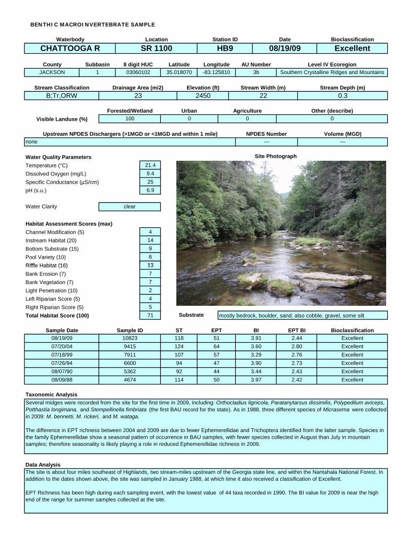
BENTHIC MACROINVERTEBRATE SAMPLE
Waterbody Location Station ID Date Bioclassification
CHATTOOGA R SR 1100 HB9 08/19/09 Excellent
County Subbasin 8 digit HUC Latitude Longitude AU Number Level IV EcoregionJACKSON 1 03060102 35.018070 -83.125810 3b Southern Crystalline Ridges and Mountains
Stream Classification Drainage Area (mi2) Elevation (ft) Stream Width (m) Stream Depth (m)B;Tr,ORW 23 2450 22 0.3
Forested/Wetland Urban Agriculture Other (describe)Visible Landuse (%) 100 0 0 0
Upstream NPDES Dischargers (>1MGD or <1MGD and within 1 mile) NPDES Number Volume (MGD)none --- ---
Water Quality Parameters Site Photograph Temperature (°C) 21.4Dissolved Oxygen (mg/L) 9.4Specific t S/cm) Conduc ance (µ 25pH (s.u.) 6.9
Water Clarity clear
Habitat Assessment Scores (max)Channel M icatiodif on (5) 4Instream at Habit (20) 14Bottom tr Subs ate (15) 9Pool Variety (10) 6Riffle H at (Riffl atabit 16) 13e Habit (16) 13Bank Erosion (7) 7Bank Vegetation (7) 7Light P ienetrat on (10) 2Left c Riparian S ore (5) 4Right c Riparian S ore (5) 5Total i cor Hab tat S e (100) 71 Substrate mostly bedrock, boulder, sand; also cobble, gravel, some silt
Sample Date Sample ID ST EPT BI EPT BI Bioclassification08/19/09 10823 118 51 3.91 2.44 Excellent07/20/04 9415 124 64 3.60 2.80 Excellent07/18/99 7911 107 57 3.29 2.76 Excellent07/26/94 6600 94 47 3.90 2.73 Excellent08/07/90 5362 92 44 3.44 2.43 Excellent08/09/88 4674 114 50 3.97 2.42 Excellent
Taxonomic AnalysisSeveral midges were recorded from the site for the first time in 2009, including: Orthocladius lignicola, Paratanytarsus dissimilis, Polypedilum aviceps, Potthastia longimana, and Stempellinella fimbriata (the first BAU record for the state). As in 1988, three different species of Micrasema were collected in 2009: M. bennetti, M. rickeri, and M. wataga.
The difference in EPT richness between 2004 and 2009 are due to fewer Ephemerellidae and Trichoptera identified from the latter sample. Species in the family Ephemerellidae show a seasonal pattern of occurrence in BAU samples, with fewer species collected in August than July in mountain samples; therefore seasonality is likely playing a role in reduced Ephemerellidae richness in 2009.
Data AnalysisThe site is about four miles southeast of Highlands, two stream-miles upstream of the Georgia state line, and within the Nantahala National Forest. In addition to the dates shown above, the site was sampled in January 1988, at which time it also received a classification of Excellent.
EPT Richness has been high during each sampling event, with the lowest value of 44 taxa recorded in 1990. The BI value for 2009 is near the high end of the range for summer samples collected at the site.

BENTHIC MACROINVERTEBRATE SAMPLE
Waterbody Location Station ID Date Bioclassification
BIG CR SR 1608 HB14 08/19/09 Excellent
County Subbasin 8 digit HUC Latitude Longitude AU Number Level IV EcoregionMACON 1 03060102 35.008889 -83.159722 3-10-3 Southern Crystalline Ridges and Mountains
Stream Classification Drainage Area (mi2) Elevation (ft) Stream Width (m) Stream Depth (m)C;Tr,ORW 5.1 2510 10 0.4
Forested/Wetland Urban Agriculture Other (describe)Visible Landuse (%) 100 0 0 0
Upstream NPDES Dischargers (>1MGD or <1MGD and within 1 mile) NPDES Number Volume (MGD)none --- ---
Water Quality Parameters Site Photograph Temperature (°C) 19.7Dissolved Oxygen (mg/L) 7.4Specific t S/cm) Conduc ance (µ 20pH (s.u.) 5.9
Water Clarity clear
Habitat Assessment Scores (max)Channel M icatiodif on (5) 5Instream at (Instream at Habit 20) 11Habit (20) 11Bottom tr Subs ate (15) 5Pool Variety (10) 9Riffl ate Habit (16) 14Bank Erosion (7) 5Bank Vegetation (7) 5Light P ienetrat on (10) 10Left c Riparian S ore (5) 4Right c Riparian S ore (5) 4Total i cor Hab tat S e (100) 72 Substrate mostly bedrock, sand, boulder; some cobble and silt
Sample Date Sample ID ST EPT BI EPT BI Bioclassification08/19/09 10824 --- 42 --- 2.74 Excellent07/21/04 9432 --- 45 --- 2.47 Excellent08/05/87 4195 99 49 3.17 2.18 Excellent
Taxonomic AnalysisThe EPT communities between 2004 and 2009 were similar. All taxa collected in 2004 and uncollected in 2009 were rare in the sample. Four taxa were common in the 2009 sample and uncollected in 2004: Maccaffertium pudicum, Neoephemera purpurea, Glossosoma, and Lepidostoma . Those four taxa are sensitive to the presence of pollutants.
Data AnalysisThe site is about three miles southeast of Highlands, and 1.6 stream-miles upstream of the Georgia state line. Much of the catchment is within the Nantahala National Forest; headwaters include the southeastern limits of Highlands. The site was sampled for basinwide assessment in 2004 and 2009; prior basinwide sampling occurred at a point about one stream-mile upstream of the current site and just upstream of Little Creek. Both sites have received classifications of Excellent following each sampling event.
Only the two most recent sampling events at the site are directly comparable (the 1987 event used Full Scale rather than EPT collection methods) with respect to EPT richness and EPT BI values. With only two data points it is not advisable to suggest trends in water quality at the site using those two metrics. Continued basinwide sampling using EPT methods is expected.

Water Quality ParametersTemperature (°C) 17.6Dissolved Oxygen (mg/L) 8.4Specific Conductance (µS/cm) 20pH (s.u.) 6.1
Channel Modification (5) 5Instream Habitat (20) 20Bottom Substrate (15) 15P l V i t (10) 4
Bioclassification
TALLULAH R OFF TATE CITY RD HB42 08/20/09 Excellent
BENTHIC MACROINVERTEBRATE SAMPLE
Waterbody Location Station ID Date
AU Number Level IV EcoregionClay 1 03060102 34.998460 -83.556980 3-11 Southern Crystalline Ridges and Mountains
County Subbasin 8 digit HUC Latitude Longitude
C;Tr 4.5 2570 7 0.3Stream Classification Drainage Area (mi2) Elevation (ft) Stream Width (m) Stream Depth (m)
Forested/Wetland Urban Agriculture Other (describe)Visible Landuse (%) 100 0 0 0
Upstream NPDES Dischargers (>1MGD or <1MGD and within 1 mile) NPDES Number Volume (MGD)none --- ---
Site Photograph
Water Clarity clear
Habitat Assessment Scores (max)
Pool Variety (10) 4Riffle Habitat (16) 16Bank Erosion (7) 6Bank Vegetation (7) 7Light Penetration (10) 9Left Riparian Score (5) 5Right Riparian Score (5) 4Total Habitat Score (100) 91
BI EPT BI
Substrate mostly cobble, boulder, gravel; some sand and bedrock
Taxonomic AnalysisThe stonefly Hansonoperla appalachia was collected here; this is one of only four BAU records for the genus and species in the state to date.
Data AnalysisThe site is 15 miles southwest of Franklin, and 0.4 stream-miles upstream of the Georgia state line. The catchment is almost entirely contained by the Southern Nantahala Wilderness. Prior to the 2009 basinwide sample there had been no benthic data collected by the BAU for the Tallulah River catchment.
The high EPT Richness and very low EPT BI reflect the high quality of water at the site; the catchment should be considered for reclassification to High Quality Waters or Outstanding Resource Waters.
Bioclassification08/20/09 10825 --- 48 --- 1.93 Excellent
Sample Date Sample ID ST EPT