BINGHAM HALL, KING STREET, CIRENCESTER,...
21
BINGHAM HALL, KING STREET, CIRENCESTER, GLOUCESTERSHIRE ARCHAEOLOGICAL EVALUATION C.A.T JOB: 0731 C.A.T REPORT: 98878 DATE: MARCH 1998 This report has been researched and compiled with all reasonable skill, care, and attention to detail within the terms of the project as specified by the Client and within the general terms and conditions of Cotswold Archaeological Trust Ltd. The Trust shall not be liable for any inaccuracy, error or omission in the report or other documents produced as part of the Consultancy and no liability is accepted for any claim, loss or damage howsoever arising from any opinion stated or conclusion or other material contained in this report or other documents supplied as part of the Consultancy. This report is confidential to the Client. Cotswold Archaeological Trust Ltd accept no responsibility whatsoever to third parties to whom this report, or any part of it is made known. Any such party relies upon this report entirely at their own risk. © Cotswold Archaeological Trust Headquarters Building, Kemble Business Park, Cirencester, Gloucestershire, GL7 6BQ Tel. 01285 771022 Fax. 01285 771033
Transcript of BINGHAM HALL, KING STREET, CIRENCESTER,...

BINGHAM HALL, KING STREET, CIRENCESTER, GLOUCESTERSHIRE
ARCHAEOLOGICAL EVALUATION
C.A.T JOB: 0731 C.A.T REPORT: 98878
DATE: MARCH 1998
This report has been researched and compiled with all reasonable skill, care, and attention to detail within the terms of the project as specified by the Client and within the general terms and conditions of Cotswold Archaeological Trust Ltd. The Trust shall not be liable for any inaccuracy, error or omission in the report or other documents produced as part of the Consultancy and no liability is accepted for any claim, loss or damage howsoever arising from any opinion stated or conclusion or other material contained in this report or other documents supplied as part of the Consultancy. This report is confidential to the Client. Cotswold Archaeological Trust Ltd accept no responsibility whatsoever to third parties to whom this report, or any part of it is made known. Any such party relies upon this report entirely at their own risk.
© Cotswold Archaeological Trust
Headquarters Building, Kemble Business Park, Cirencester, Gloucestershire, GL7 6BQ Tel. 01285 771022 Fax. 01285 771033

Bingham Hall, King Street, Cirencester, Gloucestershire: Archaeological Evaluation
1
CONTENTS
CONTENTS ..................................................................................................................... 1
LIST OF ILLUSTRATIONS ........................................................................................... 2
GLOSSARY..................................................................................................................... 3
SUMMARY ..................................................................................................................... 5
1. INTRODUCTION ........................................................................................................ 6
1.1 Introduction ...................................................................................................... 6 1.2 Geology and Topography ................................................................................. 6 1.3 Archaeological and Historical Background ..................................................... 6 1.4 Methodology ..................................................................................................... 8
2. EVALUATION RESULTS.......................................................................................... 10
2.1 General ............................................................................................................. 10
3. DISCUSSION AND CONCLUSIONS ........................................................................ 12
4. ACKNOWLEDGEMENTS ......................................................................................... 13
5. BIBLIOGRAPHY ........................................................................................................ 13

Bingham Hall, King Street, Cirencester, Gloucestershire: Archaeological Evaluation
2
LIST OF ILLUSTRATIONS
Fig.1 Location plan .......................................................................................................... 14 Fig.2 Location of test-pit .................................................................................................. 15 Fig.3 South-west, north-west and north-east facing sections of test-pit .......................... 16 Fig.4 Plan of excavated test-pit ........................................................................................ 17

Bingham Hall, King Street, Cirencester, Gloucestershire: Archaeological Evaluation
3
GLOSSARY
ARCHAEOLOGY
For the purposes of this project, archaeology is taken to mean the study of past human societies through
their material remains, from prehistoric times to the modern era. No rigid upper date limit has been set, but
AD 1900 is used as a general cut-off point.
CONTEXT
The simplest level of excavated archaeological data, i.e. a context could be the cut of a ditch (shown as -
[1]), or its fill (shown as (2)).
MEDIEVAL
Taken here as the period from the Norman invasion in AD 1066 to approximately AD 1500.
MONUMENT
The expression monument is statutorily defined in the Ancient Monuments and Archaeological Areas Act
1979 as follows:
(a) Any building, structure, or work whether above or below the surface of the land, and any cave or
excavation; (b) any site comprising the remains of, any vehicle, vessel, aircraft or other movable structure
or part thereof, which neither constitutes nor forms part of any work which is a monument within
paragraph (a) above. The site of a monument includes not only the land in or on which it is situated, but
also any land comprising or adjoining it which is essential for its support and preservation.
NATURAL
Defined in archaeological terms this refers to the undisturbed natural geology of a site, e.g. Lower Lias
clay, river terrace gravels etc.
NGR
National Grid Reference given from the Ordnance Survey Grid.
OD
Ordnance Datum; used to express a given height above mean sea level.
POT-SHERD
A fragment of a pottery vessel.
PRN

Bingham Hall, King Street, Cirencester, Gloucestershire: Archaeological Evaluation
4
Principal Record Number (used for entries on the County SMR)
ROMANO-BRITISH
Term used to describe a fusion of indigenous late Iron Age traditions with Roman culture, often
abbreviated as `R-B.'
SITE
Sites may be defined as `windows' onto the archaeological resource, e.g. an excavation, aerial photograph,
or an old map. Any of these may reveal certain archaeological features (pits, ditches, etc) which can be
classed as components, but not monuments.

Bingham Hall, King Street, Cirencester, Gloucestershire: Archaeological Evaluation
5
SUMMARY
In February 1998, Cotswold Archaeological Trust was commissioned by the Trustees
of the Bingham Hall to undertake an archaeological evaluation at the Bingham Hall,
King Street, Cirencester, Gloucestershire. The work was undertaken in advance of the
submission of a planning application for the construction of an extension to the
existing kitchen, situated to the rear of the present building.
The study area is located within Insula IX of the Roman town of Corinium
Dobunnorum and a number of important archaeological deposits and features have
been recorded within and near to the proposed development site.
The evaluation identified a crushed limestone mortar surface at a depth of 0.8m across
the extent of the excavated area.

Bingham Hall, King Street, Cirencester, Gloucestershire: Archaeological Evaluation
6
1. INTRODUCTION
1.1 Introduction
1.1.1 This report presents the results of an archaeological evaluation conducted
between the 12th and 13th March 1998, at the Bingham Hall, King Street,
Cirencester, Gloucestershire. The site is centered on NGR SP 0280 0135
(Fig.1)
1.1.2 The evaluation was undertaken prior to the submission of a planning
application for the construction of an extension of the kitchen to the rear of
the building.
1.2 Geology and Topography
1.2.1 The underlying solid geology of the study area comprises Forest Marble of the
middle Jurassic period overlain by Quaternary deposits of alluvium associated
with the River Churn. These deposits vary from pre-Holocene gravels to later
alluvial silts. The natural substrate was not encountered during the course of
the evaluation.
1.2.2 The site is situated on flat ground at approximately 108m OD, within the
confines of a lawned garden at the rear of the Bingham Hall, some 0.5km
from Cirencester town centre (Fig.1).
1.3 Archaeological and Historical Background
1.3.1 The study area lies within Insula IX of the Roman town of Corinium
Dobunnorum, the civitas or tribal capital of the Dubonni. Although the study
area lies outside of the notification areas of the Scheduled Ancient
Monument, Corinium Roman Town (Glos SAM 361), a number of important

Bingham Hall, King Street, Cirencester, Gloucestershire: Archaeological Evaluation
7
archaeological deposits and features have been recorded both within and close
to the proposed development area.
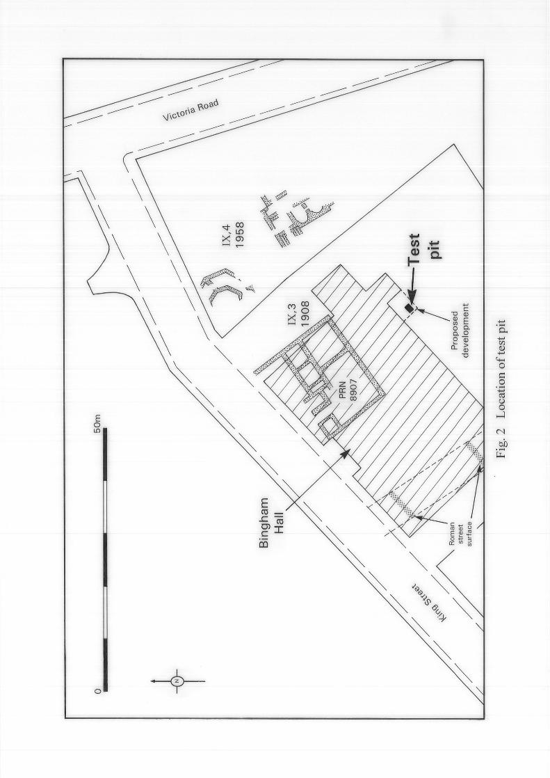
1.3.2 In 1908, part of a Roman building (PRN 8907) (Building IX,3, McWhirr,
1986, 193) and a north to south orientated Roman street, presumed to be
Ermin Street, were revealed during construction work for the Bingham Hall
(Fig.2). In 1929 a mosaic was uncovered 12m north-east of the Bingham
Hall. Excavations undertaken in 1958 between the Bingham Hall and
Victoria Road, again revealed the mosaic, along with structural remains of at
least one further building (Fig.2). The building contained a polygonal
structure, broadly interpreted as a heated triclinium, and a twin apsed room,
interpreted as a caldarium of a small domestic bath house (Holbrook, 1994).
1.3.3 It has been suggested (ibid) that the arrangements of the rooms within
Building IX,3 may represent a winged corridor house, sited adjacent to Ermin
Street. Although it remains unclear whether Building IX,3 and Building IX,4
are part of the same domestic complex, broad comparisons may be drawn
with the building at Woolaston, Glos where an octagonal room lay to the rear
of a corridored façade.
1.3.4 In 1991, a watching brief 40m north-east of study area, observed a Romano-
British wall (PRN 16240) orientated north-east to south-west at a depth of 1m
below the modern surface of King’s Street (Barber, 1992).
1.3.5 Within the immediate vicinity of the study area, a further Romano-British
building (PRN 662) and a mosaic (PRN 671) are recorded 75m and 50m
respectively from the Bingham Hall.
1.3.6 Recent archaeological work undertaken at the south-western extent of St
Michael’s Field, revealed rough angular limestone debris containing an
assemblage of fourth century pottery at depths varying from 0.15m to 0.60m
below the modern ground surface (Bateman, 1995).

Bingham Hall, King Street, Cirencester, Gloucestershire: Archaeological Evaluation
8
1.3.7 No evidence of medieval activity is recorded within the general vicinity of the
study area, and it is suggested the study area lay outside of the township
boundary of medieval Cirencester (Slater, 1976).
1.3.8 Within the post-medieval period, cartographic evidence from the Cirencester
Tithe Map (1838) indicates the study area was contained within the nurseries
and orchards which filled the southern half of the town (Gerrard, 1994). The
Ordnance Survey First Edition map of 1875 illustrates the study area as part
of the grounds of Watermoor House.
1.4 Methodology
1.4.1 The aim of the evaluation was to establish the nature, depth and extent of any
archaeological deposits within the study area, in order that an informed
decision on their importance could be made. This information would then be
used to decide whether any remains were of significant importance to warrant
preservation in situ or whether mitigation should be made to limit any damage
to the archaeological deposits.
1.4.2 The evaluation was undertaken in accordance with Planning Policy Guidance
Note 16.
1.4.3 A 1.5m by 1m test-pit was excavated within the area of the proposed
development, to the top of the first significant archaeological deposits
encountered. The dimensions of the test-pit allowed 10% coverage of the
area of the proposed development. All excavation was carried out by hand to
professional standards.
1.4.4 The work was carried out in accordance with the ‘Standard and Guidance for
Field Evaluation’ issued by the Institute of Field Archaeologists (IFA, 1994);
the ‘Statement of Standards and Practices appropriate for Archaeological
Fieldwork in Gloucestershire’ issued by the Gloucestershire County Council

Bingham Hall, King Street, Cirencester, Gloucestershire: Archaeological Evaluation
9
Archaeology Section; and the ‘Management of Archaeological Projects’
(MAP 2) issued by English Heritage.
1.4.5 All identified deposits were recorded in accordance with the CAT Technical
Manual 1 Field Recording Manual (1996).
1.4.6 A full written, drawn and photographic record of the evaluation was compiled
in accordance with the archaeological project design.
1.4.7 All artefactual material was bagged and numbered with unique numbers
relating to the context record. This was done in accordance with the CAT
Technical Manual 3 Treatment of Finds Immediately after Excavation (1995).
1.4.8 A monitoring visit was made by Mr C. Parry, Archaeological Officer,
Gloucestershire County Council, on the 12th March 1998.
1.4.9 The completed site archive and the finds, with the legal landowners’ consent,
will be deposited with Corinium Museum, Cirencester, Gloucestershire.

Bingham Hall, King Street, Cirencester, Gloucestershire: Archaeological Evaluation
10
2. EVALUATION RESULTS
2.1 General
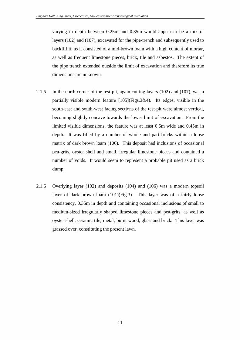
2.1.1 A crushed limestone mortar surface (107) was encountered across the extent
of the test-pit at a general depth of 0.8m below existing ground level. This
contained frequent inclusions of irregularly-shaped limestone pieces, varying
in size from small to large (Fig.4).
2.1.2 Generally overlying surface (107), was a patchy, shallow layer of pea-grits
(108)(Fig.3). This deposit was never more than 0.02m in depth and probably
originated in the overlying soil layers and was deposited over surface (107) as
a result of worm action.
2.1.3 Overlying surface (107) and layer (108) was a layer of dark brown loam
(102)(Fig.3). This deposit had a fairly loose consistency and a general depth
of 0.4m. It contained frequent irregularly-shaped limestone pieces, small to
large in size. A large amount of artefactual material was recovered from this
deposit, containing a high percentage of oyster shell. Other finds included
ceramic and stone tile, animal bone, glass, metal, metal slag and pottery. The
finds were evidently predominately Romano-British in date, but did include
the odd sherd of post-medieval pottery and clay-pipe fragment. This layer
may be the result of extensively worked garden soils, alternatively, the
quantity of artefactual material retrieved may indicate that this layer is
redeposited material, used to landscape the ground levels after the
construction of the Bingham Hall in 1908.
2.1.4 Extending a maximum of 0.2m into the test-pit, cutting layers (102) and (107)
along the north-west section of the test-pit, was a modern pipe-trench
[103](Figs.3&4). This was aligned east-north-east/west-south-west, with part
of the pipe visible in the southern corner of the test-pit. Once the pipe had
been laid, it was evidently covered in a layer of concrete (109) and the
remaining void in the pipe trench filled with deposit (104). This deposit,
Bingham Hall, King Street, Cirencester, Gloucestershire: Archaeological Evaluation
11
varying in depth between 0.25m and 0.35m would appear to be a mix of
layers (102) and (107), excavated for the pipe-trench and subsequently used to
backfill it, as it consisted of a mid-brown loam with a high content of mortar,
as well as frequent limestone pieces, brick, tile and asbestos. The extent of
the pipe trench extended outside the limit of excavation and therefore its true
dimensions are unknown.
2.1.5 In the north corner of the test-pit, again cutting layers (102) and (107), was a
partially visible modern feature [105](Figs.3&4). Its edges, visible in the
south-east and south-west facing sections of the test-pit were almost vertical,
becoming slightly concave towards the lower limit of excavation. From the
limited visible dimensions, the feature was at least 0.5m wide and 0.45m in
depth. It was filled by a number of whole and part bricks within a loose
matrix of dark brown loam (106). This deposit had inclusions of occasional
pea-grits, oyster shell and small, irregular limestone pieces and contained a
number of voids. It would seem to represent a probable pit used as a brick
dump.
2.1.6 Overlying layer (102) and deposits (104) and (106) was a modern topsoil
layer of dark brown loam (101)(Fig.3). This layer was of a fairly loose
consistency, 0.35m in depth and containing occasional inclusions of small to
medium-sized irregularly shaped limestone pieces and pea-grits, as well as
oyster shell, ceramic tile, metal, burnt wood, glass and brick. This layer was
grassed over, constituting the present lawn.
Bingham Hall, King Street, Cirencester, Gloucestershire: Archaeological Evaluation
12
3. DISCUSSION AND CONCLUSIONS
3.1 The crushed limestone mortar surface encountered during the evaluation is
almost certainly Romano-British in date. The fact that it does not consist
entirely of mortar but has frequent limestone inclusions, thus creating a fairly
rough finish, suggests that it may be an external surface. It is possible that
this may be the first recorded length of the previously postulated street which
crosses Ermin Street and forms the southern boundary of insulae VIII and IX.
3.2 Due to the looseness of the layers overlying the surface (107) and the lack of
any build-up layers associated with it, during the course of the fieldwork it
became evident that the study area had been previously disturbed , either
during construction of the Bingham Hall in 1908 or subsequently, due to
extensive working of the soils.

Bingham Hall, King Street, Cirencester, Gloucestershire: Archaeological Evaluation
13
4. ACKNOWLEDGEMENTS
Cotswold Archaeological Trust would like to thank Mr. P. Norton, Manager of the
Bingham Hall and Mr. C. Parry, Archaeology Officer, Gloucestershire County
Council, for their assistance during the course of this project.
The fieldwork was carried out by Mark Brett. This report has been compiled by Mark
Brett and the illustrations prepared by Peter Moore.
5. BIBLIOGRAPHY
Gerrard, C.M. 1984 Cirencestre: ‘A Medium-Sized Market Town in the Medieval
Period’ in Darvill, T.C. and Gerrard, C.M. 1994 Cirencester – Town and Landscape
Holbrook, N. 1994 ‘Corinium Dobunnorum: Roman Civitas Capital and Provincial
Capital’ in Darvill, T.C. and Gerrard, C.M. 1994 Cirencester – Town and Landscape
Johnson, C. 1992 ‘Kings Street, Cirencester’ in Barber, A. 1992 Archaeological
Watching Briefs 1990-1992 Miscellaneous Reports Volume II CAT Typescript Report
9279
McWhirr, A.D. 1986 Houses in Roman Cirencester
Slater, T 1976 ‘The Town and its Region in the Anglo-Saxon and Medieval Periods’
in McWhirr A.D. (ed) 1976 Archaeology and History of Cirencester

Bingham Hall, King Street, Cirencester, Gloucestershire: Archaeological Evaluation
14
Fig.1 Location plan

Bingham Hall, King Street, Cirencester, Gloucestershire: Archaeological Evaluation
15
Fig.2 Location of test-pit

Bingham Hall, King Street, Cirencester, Gloucestershire: Archaeological Evaluation
16
Fig.3 South-west, north-west and north-east facing sections of test-pit

Bingham Hall, King Street, Cirencester, Gloucestershire: Archaeological Evaluation
17
Fig.4 Plan of excavated test-pit