BILLING CODE 3510-22-P DEPARTMENT OF … The planned fiber optic cable-laying project will occur in...
65
This document is scheduled to be published in the Federal Register on 03/30/2016 and available online at http://federalregister.gov/a/2016-07109 , and on FDsys.gov 1 BILLING CODE 3510-22-P DEPARTMENT OF COMMERCE National Oceanic and Atmospheric Administration RIN 0648-XE442 Takes of Marine Mammals Incidental to Specified Activities; Taking Marine Mammals Incidental to Subsea Cable-laying Operations in the Bering, Chukchi, and Beaufort Seas AGENCY: National Marine Fisheries Service (NMFS), National Oceanic and Atmospheric Administration (NOAA), Commerce. ACTION: Notice; proposed incidental harassment authorization; request for comments. SUMMARY: NMFS has received an application from Quintillion Subsea Operations, LLC (Quintillion) for an Incidental Harassment Authorization (IHA) to take marine mammals, by harassment, incidental to a subsea cable-laying operation in the state and federal waters of the Bering, Chukchi, and Beaufort seas, Alaska, during the open-water season of 2016. Pursuant to the Marine Mammal Protection Act (MMPA), NMFS is requesting comments on its proposal to issue an IHA to Quintillion to incidentally take, by Level B Harassments, marine mammals during the specified activity. DATES: Comments and information must be received no later than [insert date 30 calendar days after date of publication in the FEDERAL REGISTER]. ADDRESSES: Comments on the application should be addressed to Jolie Harrison, Chief, Permits and Conservation Division, Office of Protected Resources, National Marine Fisheries Service, 1315 East-West Highway, Silver Spring, MD 20910. The mailbox address for providing email comments is [email protected]. Comments sent via e-mail, including all
Transcript of BILLING CODE 3510-22-P DEPARTMENT OF … The planned fiber optic cable-laying project will occur in...

This document is scheduled to be published in theFederal Register on 03/30/2016 and available online at http://federalregister.gov/a/2016-07109, and on FDsys.gov
1
BILLING CODE 3510-22-P
DEPARTMENT OF COMMERCE
National Oceanic and Atmospheric Administration
RIN 0648-XE442
Takes of Marine Mammals Incidental to Specified Activities; Taking Marine Mammals
Incidental to Subsea Cable-laying Operations in the Bering, Chukchi, and Beaufort Seas
AGENCY: National Marine Fisheries Service (NMFS), National Oceanic and Atmospheric
Administration (NOAA), Commerce.
ACTION: Notice; proposed incidental harassment authorization; request for comments.
SUMMARY: NMFS has received an application from Quintillion Subsea Operations, LLC
(Quintillion) for an Incidental Harassment Authorization (IHA) to take marine mammals, by
harassment, incidental to a subsea cable-laying operation in the state and federal waters of the
Bering, Chukchi, and Beaufort seas, Alaska, during the open-water season of 2016. Pursuant to
the Marine Mammal Protection Act (MMPA), NMFS is requesting comments on its proposal to
issue an IHA to Quintillion to incidentally take, by Level B Harassments, marine mammals
during the specified activity.
DATES: Comments and information must be received no later than [insert date 30 calendar
days after date of publication in the FEDERAL REGISTER].
ADDRESSES: Comments on the application should be addressed to Jolie Harrison, Chief,
Permits and Conservation Division, Office of Protected Resources, National Marine Fisheries
Service, 1315 East-West Highway, Silver Spring, MD 20910. The mailbox address for
providing email comments is [email protected]. Comments sent via e-mail, including all

2
attachments, must not exceed a 25-megabyte file size. NMFS is not responsible for comments
sent to addresses other than those provided here.
Instructions: All comments received are a part of the public record and will generally be
posted to http://www.nmfs.noaa.gov/pr/permits/incidental.htm without change. All Personal
Identifying Information (for example, name, address, etc.) voluntarily submitted by the
commenter may be publicly accessible. Do not submit Confidential Business Information or
otherwise sensitive or protected information.
An electronic copy of the application may be obtained by writing to the address specified
above, telephoning the contact listed below (see FOR FURTHER INFORMATION
CONTACT), or visiting the internet at: http://www.nmfs.noaa.gov/pr/permits/incidental.htm.
The following associated documents are also available at the same internet address: Plan of
Cooperation. Documents cited in this notice may also be viewed, by appointment, during regular
business hours, at the aforementioned address.
NMFS is also preparing a draft Environmental Assessment (EA) in accordance with the
National Environmental Policy Act (NEPA) and will consider comments submitted in response
to this notice as part of that process. The draft EA will be posted at the foregoing internet site.
FOR FURTHER INFORMATION CONTACT: Shane Guan, Office of Protected Resources,
NMFS, (301) 427-8401.
SUPPLEMENTARY INFORMATION:
Background
Sections 101(a)(5)(A) and (D) of the MMPA (16 U.S.C. 1361 et seq.) direct the Secretary
of Commerce to allow, upon request, the incidental, but not intentional, taking of small numbers
of marine mammals by U.S. citizens who engage in a specified activity (other than commercial

3
fishing) within a specified geographical region if certain findings are made and either regulations
are issued or, if the taking is limited to harassment, a notice of a proposed authorization is
provided to the public for review.
An authorization for incidental takings shall be granted if NMFS finds that the taking will
have a negligible impact on the species or stock(s), will not have an unmitigable adverse impact
on the availability of the species or stock(s) for subsistence uses (where relevant), and if the
permissible methods of taking and requirements pertaining to the mitigation, monitoring, and
reporting of such takings are set forth. NMFS has defined “negligible impact” in 50 CFR
216.103 as “an impact resulting from the specified activity that cannot be reasonably expected to,
and is not reasonably likely to, adversely affect the species or stock through effects on annual
rates of recruitment or survival.”
Except with respect to certain activities not pertinent here, the MMPA defines
"harassment" as: any act of pursuit, torment, or annoyance which (i) has the potential to injure a
marine mammal or marine mammal stock in the wild [Level A harassment]; or (ii) has the
potential to disturb a marine mammal or marine mammal stock in the wild by causing disruption
of behavioral patterns, including, but not limited to, migration, breathing, nursing, breeding,
feeding, or sheltering [Level B harassment].
Summary of Request
On October 29, 2015, NMFS received an IHA application and marine mammal
mitigation and monitoring plan (4MP) from Quintillion for the taking of marine mammals
incidental to conducting subsea cable laying activities in the U.S. Bering, Chukchi, and Beaufort
seas. After receiving NMFS comments on the initial application, Quintillion made revisions and

4
updated its IHA application and 4MP on February 3, 2016. NMFS determined that the
application and the 4MP were adequate and complete on February 5, 2016.
Quintillion proposes to install a subsea fiber optic network cable along the northern and
western coasts of Alaska in the U.S. Bering, Chukchi, and Beaufort seas during the 2016 Arctic
open-water season. The proposed activity would occur between June 1 and October 31, 2016.
Noise generated from cable vessel’s dynamic positioning thruster could impact marine mammals
in the vicinity of the activities. Take, by Level B harassments, of individuals of 8 species of
marine mammals is proposed to be authorized from the specified activity.
Description of the Specified Activity
Overview
On October 29, 2015, NMFS received an application from Quintillion requesting an
authorization for the harassment of small numbers of marine mammals incidental to subsea
cable-laying operations in the Bering, Chukchi, and Beaufort seas off Alaska. After addressing
comments from NMFS, Quintillion modified its application and submitted revised applications
and 4MP on February 3, 2016. Quintillion’s proposed activities discussed here are based on its
February 3, 2016, IHA application and 4MP.
Dates and Duration
The proposed subsea cable-laying operation is planned for the 2016 open-water season
(June 1 to October 31). All associated activities, including mobilization, pre-lay grapnel run
(PLGR), cable-laying, post lay inspection and burial (PLIB), and demobilization of survey and
support crews, would occur inclusive of the above seasonal dates. It is expected that the
operations may last all season (approximately 150 days).
Specified Geographic Region

5
The planned fiber optic cable-laying project will occur in the offshore waters of the
Bering, Chukchi, and Beaufort seas between Nome and Oliktok Point (the latter located 260 km
[162 mi] southeast of Barrow). The specific area is provided in Figure 1 of Quintillion’s IHA
application.
Detailed Description of Activities
I. Cable Network
The proposed subsea cable network is shown in Figure 1 of the IHA application. The
cable network includes the main trunk line and six branch lines. The main trunk line is 1,317 km
(818 mi) in length, and will run from the tail of the Nome branch line to the tail of the Oliktok
Point branch line (Table 1). The branch lines range between 27 km (17 mi) and 233 km (145 mi)
long. The branch lines connect to the main trunk line at the branching unit (BU), which is a piece
of hardware that allows the interconnection of the branch cable from the main trunk line to the
shore end facility. The cable is also “repeatered” in that approximately every 60 km (37 mi) a
repeater is attached to the cable that amplifies the signal. Collectively, the cable, BUs, and
repeaters make up the “submerged plant.” Depending on bottom substrate, water depth, and
distance from shore, the cable would either lay on the ocean floor or will be buried using a
plough or a remote operating vehicle (ROV) equipped for burial jetting.
II. Vessels
The cable-laying operations will be conducted from two ships, the Ile de Brehat and the
Ile de Sein, and a large cable-laying barge. Both ships are 140 m (460 ft) in length, 23 m (77 ft)
in breadth, with berths for a crew of 70. The ships are propelled by two 4,000 kW fixed-pitch
propellers. Dynamic positioning is maintained by two 1,500 kW bow thrusters, two 1,500 kW
aft thrusters, and one 1,500 kW fore thruster.
6
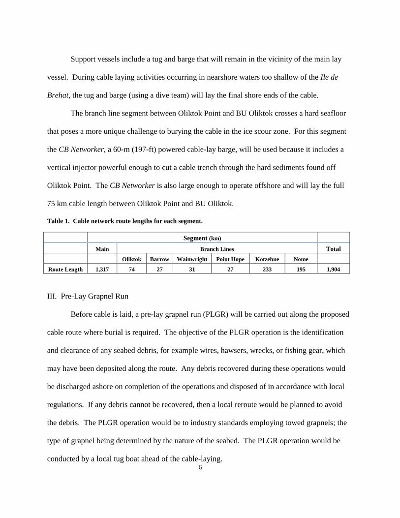
Support vessels include a tug and barge that will remain in the vicinity of the main lay
vessel. During cable laying activities occurring in nearshore waters too shallow of the Ile de
Brehat, the tug and barge (using a dive team) will lay the final shore ends of the cable.
The branch line segment between Oliktok Point and BU Oliktok crosses a hard seafloor
that poses a more unique challenge to burying the cable in the ice scour zone. For this segment
the CB Networker, a 60-m (197-ft) powered cable-lay barge, will be used because it includes a
vertical injector powerful enough to cut a cable trench through the hard sediments found off
Oliktok Point. The CB Networker is also large enough to operate offshore and will lay the full
75 km cable length between Oliktok Point and BU Oliktok.
Table 1. Cable network route lengths for each segment.
Segment (km)
Main Branch Lines Total
Oliktok Barrow Wainwright Point Hope Kotzebue Nome
Route Length 1,317 74 27 31 27 233 195 1,904
III. Pre-Lay Grapnel Run
Before cable is laid, a pre-lay grapnel run (PLGR) will be carried out along the proposed
cable route where burial is required. The objective of the PLGR operation is the identification
and clearance of any seabed debris, for example wires, hawsers, wrecks, or fishing gear, which
may have been deposited along the route. Any debris recovered during these operations would
be discharged ashore on completion of the operations and disposed of in accordance with local
regulations. If any debris cannot be recovered, then a local reroute would be planned to avoid
the debris. The PLGR operation would be to industry standards employing towed grapnels; the
type of grapnel being determined by the nature of the seabed. The PLGR operation would be
conducted by a local tug boat ahead of the cable-laying.

7
IV. Cable-Laying
The objective of the surface laying operation is to install the cable as close as possible to
the planned route with the correct amount of cable slack to enable the cable to conform to the
contours of the seabed without loops or suspensions. A slack plan would be developed that uses
direct bathymetric data and a catenary modeling system to control the ship and the cable pay out
speeds to ensure the cable is accurately placed in its planned physical position.
Where the BAS has determined that cable burial is possible, the cable would be buried
using various methods. In water depths greater than about 12 m (about 40 ft), the cable would be
buried using an SMD Heavy Duty HD3 Plough. The plough has a submerged weight of 25
tonnes (27.6 tons). The plough is pulled by the tow wire and the cable fed through a cable
depressor that pushes it into the trench. Burial depth is controlled by adjusting the front skids.
The normal tow speed is approximately 600 m/hr (approximately 0.37 mph).
In water depths less than 12 m (40 ft), burial would be by jet burial using a towed sled,
tracked ROV, or by diver jet burial, subject to seabed conditions in the area. The ROV would be
used in areas accessible to the main lay vessel. The planned ROV, the ROVJET 400 series, is
5.8 m (19.0 ft) long and 3.4 m (11.2 ft) wide and weighs 9.1 tonnes (10 tons) in air, and has both
a main and forward jet tool cable of trenching to 2 m (6.6 ft) depth.
Nearer to shore, where seasonal ice scouring occurs, the cable with be floated on the
surface and then pulled through an existing horizontal directional drilling (HDD) bore pipe to the
beach man hole (BMH) where it would be anchor-clamped and spliced to the terrestrial cable.
The floated cable portion is then lowered to the seabed by divers and buried (using a post-lay
burial method as described above) from the HDD Bore pipe seaward.
V. Post Lay Inspection and Burial

8
While it is expected that the cable trench would fill back in by natural current processes,
it is important to ensure that cable splices and BUs are fully buried, and that there are no
unnecessary plough skips at locations where burial is critical. To ensure proper burial, a post lay
inspection and burial (PLIB) would be conducted using the ROVJET 400 series mentioned
above. It is expected that PLIB would be necessary for no more than about 10 km (6.2 mi) of the
cumulative planned burial routes.
Description of Marine Mammals in the Area of the Specified Activity
The Bering, Chukchi, and Beaufort seas support a diverse assemblage of marine
mammals. Table 2 lists the 12 marine mammal species under NMFS jurisdiction with confirmed
or possible occurrence in the proposed project area.
Table 2. Marine mammal species with confirmed or possible occurrence in the proposed action area.
Common Name Scientific
Name Status Occurrence Seasonality Range Abundance
Odontocetes
Beluga whale
(Beaufort Sea
stock)
Delphinapterus
leucas
- Common
Mostly spring
and fall with
some in
summer
Mostly
Beaufort
Sea
39,258
Beluga whale
(eastern
Chukchi Sea
stock)
- Common
Mostly spring
and fall with
some in
summer
Mostly
Chukchi Sea 3,710
Beluga whale
(eastern Bering
Sea stock)
- Common Year round Bering Sea 19,186
Killer whale
(Alaska resident
stock)
Orcinus orca - Occasional/
Extralimital
Mostly
summer and
early fall
California to
Alaska 2,347
Harbor porpoise
(Bering Sea
stock)
Phocoena
phocoena -
Occasional/
Extralimital
Mostly
summer and
early fall
California to
Alaska 48,215
Mysticetes
*Bowhead
whale
(W. Arctic
stock)
Balaena
mysticetus
Endangered;
Depleted
Common
Mostly spring
and fall with
some in
summer
Russia to
Canada 19,534

9
Gray whale
(E. North
Pacific stock)
Eschrichtius
robustus -
Somewhat
common
Mostly
summer
Mexico to
the U.S.
Arctic
Ocean
20,990
*Fin whale
(N. East Pacific)
Balaenoptera
physalus
Endangered;
Depleted Rare
Mostly
summer
N.E Pacific
Ocean 1,650
*Humpback
whale (Central
North Pacific
stock) Megaptera
novaeangliae
Megaptera
novaeangliae
Endangered;
Depleted Rare
Mostly
summer
North
Pacific
Ocean
10,103
*Humpback
whale (western
North Pacific
stock)
Endangered;
Depleted Rare
Mostly
summer
North
Pacific
Ocean
1,107
Pinnipeds
*Bearded seal
(Alaska stock)
Erigathus
barbatus
Threatened;
Depleted
Common Spring and
summer
Bering,
Chukchi,
and
Beaufort
Seas
155,000
*Ringed seal
(Alaska stock) Phoca hispida
Threatened;
Depleted Common Year round
Bering,
Chukchi,
and
Beaufort
Seas
249,000
Spotted seal
(Alaska stock) Phoca largha - Common Summer
Japan to
U.S. Arctic
Ocean
460,268
Ribbon seal
(Alaska stock)
Histriophoca
fasciata Occasional Summer
Russia to
U.S. Arctic
Ocean
49,000
*Endangered, threatened, or species of concern under the Endangered Species Act (ESA); Depleted under the
MMPA
Among these species, bowhead, humpback, and fin whales, and ringed and bearded are
listed as endangered or threatened species under the Endangered Species Act (ESA). In addition,
walrus and the polar bear could also occur in the Bering, Chukchi, and Beaufort seas; however,
these species are managed by the U.S. Fish and Wildlife Service (USFWS) and are not
considered in this Notice of Proposed IHA.
Of all these species, bowhead and beluga whales and ringed, bearded, and spotted seals
are the species most frequently sighted in the proposed activity area. The proposed action area in
the Bering, Chukchi, and Beaufort seas also includes areas that have been identified as important
for bowhead whale reproduction during summer and fall and for beluga whale feeding and

10
reproduction in summer.
Most bowheads fall migrate through the Alaskan Beaufort in water depths between 15
and 200 m (50 and 656 ft) deep (Miller et al. 2002), with annual variability depending on ice
conditions. Hauser et al. (2008) conducted surveys for bowhead whales near the Colville River
Delta (near Oliktok Point) during August and September 2008, and found most bowheads
between 25 and 30 km (15.5 and 18.6 mi) north of the barrier islands (Jones Islands), with the
nearest in 18 m (60 ft) of water about 25 km (16 mi) north of the Colville River Delta. No
bowheads were observed inside the 18-m (60-ft) isobath. Most of the cable-lay activity planned
for the Beaufort Sea will occur in water deeper than 15 m (50 ft) where migrating bowhead
whales could most likely be encountered.
Three stocks of beluga whale inhabit the waters where cable-lay is planned to occur:
Beaufort Sea, Eastern Chukchi Sea, and Eastern Bering Sea (O’Corry-Crowe et al. 1997). All
three stocks winter in the open leads and polynyas of the Bering Sea (Hazard 1988). In spring,
the Beaufort Sea stock migrates through coastal leads more than 2,000 km (1,200 mi) to their
summering grounds in the Mackenzie River delta where they molt, feed, and calve in the warmer
estuarine waters (Braham et al. 1977). In late summer, these belugas move into offshore
northern waters to feed (Davis and Evans 1982, Harwood et al. 1996, Richard et al. 2001). In the
fall, they begin their migration back to their wintering grounds generally following an offshore
route as they pass through the western Beaufort Sea (Richard et al. 2001).
The Beaufort Sea stock beluga whales take a more coastal route during their fall
migration, but compared to the vanguard of population and the survey effort expended, nearshore
travel appears to be relatively rare. Most belugas recorded during aerial surveys conducted in the
Alaskan Beaufort Sea in the last two decades were found more than 65 km (40 mi) from shore

11
(Miller et al. 1999, Funk et al. 2008, Christie et al. 2010, Clarke and Ferguson 2010, Brandon et
al. 2011). For the most part, beluga whales from this stock are expected to occur well north of
the proposed cable route through the Beaufort Sea at the time of cable-lay activity.
The Eastern Chukchi Sea beluga whale stock summers in Kotzebue Sound and Kasegaluk
Lagoon where they breed and molt, and then in late summer and fall they also move in the
Beaufort Sea (Suydam et al. 2005). Suydam et al. (2005) satellite-tagged 23 beluga whales in
Kasegaluk Lagoon and found nearly all the whales move into the deeper waters of the Beaufort
Sea post-tagging. However, virtually none of the whales were found in continental shelf waters
(<200 m deep) of the Beaufort Sea, and all were in waters at least 65 km (40 mi) north of the
northern Alaska coastline. The most recent stock estimate is 3,710 animals (Allen and Angliss
2015). The planned cable-lay activity is most likely to encounter this stock whale laying the
Kotzebue and Wainwright branch lines, but the routes do avoid the Kasegaluk Lagoon breeding
and molting area.
There is little information on movements of the East Bering stock of beluga whales,
although two whales were satellite tagged in 2012 near Nome wintered in Bristol Bay (Allen and
Angliss 2015). These whales might be encountered while laying the Nome branch line.
In addition, a few gray whales are expected to be encountered along the main trunk line
route through the north Bering and Chukchi seas. However, they are expected to be commonly
observed along the nearshore segments of the branch lines, especially the Wainwright branch
where they are commonly found in large feeding groups.
Three of the ice seal species – ringed, bearded, and spotted seals – are fairly common in
the proposed subsea cable laying areas. However, there are no pinnipeds haulouts in the vicinity
of the action area.

12
Further information on the biology and local distribution of these species can be found in
Quintillion’s application (see ADDRESSES) and the NMFS Marine Mammal Stock Assessment
Reports, which are available online at: http://www.nmfs.noaa.gov/pr/sars/species.htm.
Potential Effects of the Specified Activity on Marine Mammals
This section includes a summary and discussion of the ways that the types of stressors
associated with the specified activity (e.g., operation of dynamic positioning thrusters) have been
observed to or are thought to impact marine mammals. This section may include a discussion of
known effects that do not rise to the level of an MMPA take (for example, with acoustics, we
may include a discussion of studies that showed animals not reacting at all to sound or exhibiting
barely measurable avoidance). The discussion may also include reactions that we consider to
rise to the level of a take and those that we do not consider to rise to the level of a take. This
section is intended as a background of potential effects and does not consider either the specific
manner in which this activity will be carried out or the mitigation that will be implemented or
how either of those will shape the anticipated impacts from this specific activity. The
“Estimated Take by Incidental Harassment” section later in this document will include a
quantitative analysis of the number of individuals that are expected to be taken by this activity.
The “Negligible Impact Analysis” section will include the analysis of how this specific activity
will impact marine mammals and will consider the content of this section, the “Estimated Take
by Incidental Harassment” section, the “Proposed Mitigation” section, and the “Anticipated
Effects on Marine Mammal Habitat” section to draw conclusions regarding the likely impacts
of this activity on the reproductive success or survivorship of individuals and from that on the
affected marine mammal populations or stocks.

13
When considering the influence of various kinds of sound on the marine environment, it
is necessary to understand that different kinds of marine life are sensitive to different frequencies
of sound. Based on available behavioral data, audiograms have been derived using auditory
evoked potentials, anatomical modeling, and other data. Southall et al. (2007) designate
“functional hearing groups” for marine mammals and estimate the lower and upper frequencies
of functional hearing of the groups. The functional groups and the associated frequencies are
indicated below (though animals are less sensitive to sounds at the outer edge of their functional
range and most sensitive to sounds of frequencies within a smaller range somewhere in the
middle of their functional hearing range):
Low frequency cetaceans (13 species of mysticetes): functional hearing is estimated
to occur between approximately 7 Hz and 25 kHz;
Mid-frequency cetaceans (32 species of dolphins, six species of larger toothed
whales, and 19 species of beaked and bottlenose whales): functional hearing is
estimated to occur between approximately 150 Hz and 160 kHz;
High frequency cetaceans (eight species of true porpoises, six species of river
dolphins, Kogia, the franciscana, and four species of cephalorhynchids): functional
hearing is estimated to occur between approximately 200 Hz and 180 kHz;
Phocid pinnipeds (true seals): functional hearing is estimated between 75 Hz to 100
kHz; and
Otariid pinnipeds (sea lions and fur seals): functional hearing is estimated between
100 Hz to 48 kHz.

14
Species found in the vicinity of Quintillion subsea cable-laying operation area include
four low-frequency cetacean species (Bowhead whale, gray whale, humpback whale, and fin
whale), two mid-frequency cetacean species (beluga whale and killer whale), one high-frequency
cetacean species (harbor porpoise), and four pinniped species (ringed seal, spotted seal, bearded
seal, and ribbon seal).
The proposed Quintillion subsea cable-laying operation could adversely affect marine
mammal species and stocks by exposing them to elevated noise levels in the vicinity of the
activity area.
Exposure to high intensity sound for a sufficient duration may result in auditory effects
such as a noise-induced threshold shift—an increase in the auditory threshold after exposure to
noise (Finneran et al., 2005). Factors that influence the amount of threshold shift include the
amplitude, duration, frequency content, temporal pattern, and energy distribution of noise
exposure. The magnitude of hearing threshold shift normally decreases over time following
cessation of the noise exposure. The amount of threshold shift just after exposure is the initial
threshold shift. If the threshold shift eventually returns to zero (i.e., the threshold returns to the
pre-exposure value), it is a temporary threshold shift (Southall et al., 2007).
Threshold Shift (noise-induced loss of hearing) – When animals exhibit reduced hearing
sensitivity (i.e., sounds must be louder for an animal to detect them) following exposure to an
intense sound or sound for long duration, it is referred to as a noise-induced threshold shift (TS).
An animal can experience temporary threshold shift (TTS) or permanent threshold shift (PTS).
TTS can last from minutes or hours to days (i.e., there is complete recovery), can occur in
specific frequency ranges (i.e., an animal might only have a temporary loss of hearing sensitivity
between the frequencies of 1 and 10 kHz), and can be of varying amounts (for example, an

15
animal’s hearing sensitivity might be reduced initially by only 6 dB or reduced by 30 dB). PTS is
permanent, but some recovery is possible. PTS can also occur in a specific frequency range and
amount as mentioned above for TTS.
The following physiological mechanisms are thought to play a role in inducing auditory
TS: effects to sensory hair cells in the inner ear that reduce their sensitivity, modification of the
chemical environment within the sensory cells, residual muscular activity in the middle ear,
displacement of certain inner ear membranes, increased blood flow, and post-stimulatory
reduction in both efferent and sensory neural output (Southall et al., 2007). The amplitude,
duration, frequency, temporal pattern, and energy distribution of sound exposure all can affect
the amount of associated TS and the frequency range in which it occurs. As amplitude and
duration of sound exposure increase, so, generally, does the amount of TS, along with the
recovery time. For intermittent sounds, less TS could occur than compared to a continuous
exposure with the same energy (some recovery could occur between intermittent exposures
depending on the duty cycle between sounds) (Kryter et al., 1966; Ward, 1997). For example,
one short but loud (higher SPL) sound exposure may induce the same impairment as one longer
but softer sound, which in turn may cause more impairment than a series of several intermittent
softer sounds with the same total energy (Ward, 1997). Additionally, though TTS is temporary,
prolonged exposure to sounds strong enough to elicit TTS, or shorter-term exposure to sound
levels well above the TTS threshold, can cause PTS, at least in terrestrial mammals (Kryter,
1985). Although in the case of Quintillion’s subsea cable laying operation, NMFS does not
expect that animals would experience levels high enough or durations long enough to result in
TS given that the noise levels from the operation are very low.

16
For marine mammals, published data are limited to the captive bottlenose dolphin,
beluga, harbor porpoise, and Yangtze finless porpoise (Finneran et al., 2000, 2002, 2003, 2005,
2007, 2010a, 2010b; Finneran and Schlundt, 2010; Lucke et al., 2009; Mooney et al., 2009a,
2009b; Popov et al., 2011a, 2011b; Kastelein et al., 2012a; Schlundt et al., 2000; Nachtigall et
al., 2003, 2004). For pinnipeds in water, data are limited to measurements of TTS in harbor
seals, an elephant seal, and California sea lions (Kastak et al., 1999, 2005; Kastelein et al.,
2012b).
Lucke et al. (2009) found a threshold shift (TS) of a harbor porpoise after exposing it to
airgun noise with a received sound pressure level (SPL) at 200.2 dB (peak –to-peak) re: 1 μPa,
which corresponds to a sound exposure level of 164.5 dB re: 1 μPa2 s after integrating exposure.
NMFS currently uses the root-mean-square (rms) of received SPL at 180 dB and 190 dB re: 1
μPa as the threshold above which permanent threshold shift (PTS) could occur for cetaceans and
pinnipeds, respectively. Because the airgun noise is a broadband impulse, one cannot directly
determine the equivalent of rms SPL from the reported peak-to-peak SPLs. However, applying a
conservative conversion factor of 16 dB for broadband signals from seismic surveys (McCauley,
et al., 2000) to correct for the difference between peak-to-peak levels reported in Lucke et al.
(2009) and rms SPLs, the rms SPL for TTS would be approximately 184 dB re: 1 μPa, and the
received levels associated with PTS (Level A harassment) would be higher. This is still above
NMFS’ current 180 dB rms re: 1 μPa threshold for injury. However, NMFS recognizes that TTS
of harbor porpoises is lower than other cetacean species empirically tested (Finneran & Schlundt,
2010; Finneran et al., 2002; Kastelein and Jennings, 2012).
Marine mammal hearing plays a critical role in communication with conspecifics, and
interpretation of environmental cues for purposes such as predator avoidance and prey capture.

17
Depending on the degree (elevation of threshold in dB), duration (i.e., recovery time), and
frequency range of TTS, and the context in which it is experienced, TTS can have effects on
marine mammals ranging from discountable to serious (similar to those discussed in auditory
masking, below). For example, a marine mammal may be able to readily compensate for a brief,
relatively small amount of TTS in a non-critical frequency range that occurs during a time where
ambient noise is lower and there are not as many competing sounds present. Alternatively, a
larger amount and longer duration of TTS sustained during time when communication is critical
for successful mother/calf interactions could have more serious impacts. Also, depending on the
degree and frequency range, the effects of PTS on an animal could range in severity, although it
is considered generally more serious because it is a permanent condition. Of note, reduced
hearing sensitivity as a simple function of aging has been observed in marine mammals, as well
as humans and other taxa (Southall et al., 2007), so one can infer that strategies exist for coping
with this condition to some degree, though likely not without cost.
In addition, chronic exposure to excessive, though not high-intensity, noise could cause
masking at particular frequencies for marine mammals that utilize sound for vital biological
functions (Clark et al. 2009). Acoustic masking is when other noises such as from human
sources interfere with animal detection of acoustic signals such as communication calls,
echolocation sounds, and environmental sounds important to marine mammals. Therefore, under
certain circumstances, marine mammals whose acoustical sensors or environment are being
severely masked could also be impaired from maximizing their performance fitness in survival
and reproduction.
Masking occurs at the frequency band which the animals utilize. Therefore, since noise
generated from vessels dynamic positioning activity is mostly concentrated at low frequency
18
ranges, it may have less effect on high frequency echolocation sounds by odontocetes (toothed
whales). However, lower frequency man-made noises are more likely to affect detection of
communication calls and other potentially important natural sounds such as surf and prey noise.
It may also affect communication signals when they occur near the noise band and thus reduce
the communication space of animals (e.g., Clark et al. 2009) and cause increased stress levels
(e.g., Foote et al. 2004; Holt et al. 2009).
Unlike TS, masking, which can occur over large temporal and spatial scales, can
potentially affect the species at population, community, or even ecosystem levels, as well as
individual levels. Masking affects both senders and receivers of the signals and could have long-
term chronic effects on marine mammal species and populations. Recent science suggests that
low frequency ambient sound levels have increased by as much as 20 dB (more than 3 times in
terms of sound pressure level) in the world’s ocean from pre-industrial periods, and most of these
increases are from distant shipping (Hildebrand 2009). All anthropogenic noise sources, such as
those from vessel traffic and cable-laying while operating dynamic positioning (DP) thrusters
contribute to the elevated ambient noise levels, thus increasing potential for or severity of
masking.
Finally, exposure of marine mammals to certain sounds could lead to behavioral
disturbance (Richardson et al. 1995), such as: changing durations of surfacing and dives, number
of blows per surfacing, or moving direction and/or speed; reduced/increased vocal activities;
changing/cessation of certain behavioral activities (such as socializing or feeding); visible startle
response or aggressive behavior (such as tail/fluke slapping or jaw clapping); avoidance of areas
where noise sources are located; and/or flight responses (e.g., pinnipeds flushing into water from
haulouts or rookeries).

19
The onset of behavioral disturbance from anthropogenic noise depends on both external
factors (characteristics of noise sources and their paths) and the receiving animals (hearing,
motivation, experience, demography) and is also difficult to predict (Southall et al. 2007).
Currently NMFS uses a received level of 160 dB re 1 μPa (rms) to predict the onset of behavioral
harassment from impulse noises (such as impact pile driving), and 120 dB re 1 μPa (rms) for
continuous noises (such as operating DP thrusters). No impulse noise is expected from the
Quintillion subsea cable-laying operation. For the Quintillion subsea cable-laying operation,
only the 120 dB re 1 μPa (rms) threshold is considered because only continuous noise sources
would be generated.
The biological significance of many of these behavioral disturbances is difficult to
predict, especially if the detected disturbances appear minor. However, the consequences of
behavioral modification could be biologically significant if the change affects growth, survival,
and/or reproduction, which depends on the severity, duration, and context of the effects.
Anticipated Effects on Marine Mammal Habitat
Project activities that could potentially impact marine mammal habitats include acoustical
impacts to prey resources associated with laying cable on sea bottom. Regarding the former,
however, acoustical injury from thruster noise is unlikely. Previous noise studies (e.g., Greenlaw
et al. 1988, Davis et al. 1998, Christian et al. 2004) with cod, crab, and schooling fish found little
or no injury to adults, larvae, or eggs when exposed to impulsive noises exceeding 220 dB.
Continuous noise levels from ship thrusters are generally below 180 dB, and do not create great
enough pressures to cause tissue or organ injury.
Nedwell et al. (2003) measured noise associated with cable trenching operations offshore
of Wales, and found that levels (178 dB at source) did not exceed those where significant

20
avoidance reactions of fish would occur. Cable burial operations involve the use of ploughs or
jets to cut trenches in the sea floor sediment. Cable ploughs are generally used where the
substrate is cohesive enough to be “cut” and laid alongside the trench long enough for the cable
to be laid at depth. In less cohesive substrates, where the sediment would immediately settle back
into the trench before the cable could be laid, jetting is used to scour a more lasting furrow. The
objective of both is to excavate a temporary trench of sufficient depth to fully bury the cable.
The plough blade is 0.2 m (0.7 ft) wide producing a trench of approximately the same width.
Jetted trenches are somewhat wider depending on the sediment type. Potential impacts to marine
mammal habitat and prey include 1) crushing of benthic and epibenthic invertebrates with the
plough blade, plough skid, or ROV track, 2) dislodgement of benthic invertebrates onto the
surface where they may die, and 3) and the settlement of suspended sediments away from the
trench where they may clog gills or feeding structures of sessile invertebrates or smother
sensitive species (BERR 2008). However, the footprint of cable trenching is generally restricted
to 2 to 3 m (7-10 ft) width (BERR 2008), and the displaced wedge or berm is expected to
naturally backfill into the trench. Jetting results in more suspension of sediments, which may
take days to settle during which currents may transport it well away (up to several kilometers)
from its source. Suspended sand particles generally settle within about 20 m (66 ft). BERR
(2008) reviewed the effect of offshore wind farm construction, including laying of power and
communication cables, on the environment. Based on a rating of 1 to 10, they concluded that
sediment disturbance from plough operations rated the lowest at 1, with jetting rating from 2 to
4, depending on substrate. Dredging rated the highest (6) relative sediment disturbance.
The maximum amount of trenching possible is about 1,900 km (1,180 mi), but the width
of primary effect is only about 3 m (10 ft). Thus, the maximum impact footprint is less than 6

21
km2 (2.3 mi
2), an insignificantly small area given the Chukchi Sea area alone is 595,000 km
2
(230,000 mi2). Overall, cable-laying effects to marine mammal habitat and prey resources are
considered not significant.
Proposed Mitigation
In order to issue an incidental take authorization (ITA) under section 101(a)(5)(D) of the
MMPA, NMFS must set forth the permissible methods of taking pursuant to such activity, and
other means of effecting the least practicable impact on such species or stock and its habitat,
paying particular attention to rookeries, mating grounds, and areas of similar significance, and on
the availability of such species or stock for taking for certain subsistence uses (where relevant).
For the proposed Quintillion open-water subsea cable-laying operations in the Bering,
Chukchi, and Beaufort seas, NMFS worked with Quintillion and its contractor to propose the
following mitigation measures to minimize the potential impacts to marine mammals in the
project vicinity as a result of the activities. The primary purpose of these mitigation measures is
to detect marine mammals and avoid vessel interactions during the pre- and post-cable-laying
activities. Due to the nature of the activities, the vessel will not be able to engage direction
alternation during cable-laying operations. However, since the cable-laying vessel will be
moving at a slow speed of 600 meter/hour (0.37 mile per hour or 0.32 knot) during cable-laying
operation, it is highly unlikely that the cable vessel would have physical interaction with marine
mammals. The following are mitigation measures proposed to be included in the IHA (if
issued).
(a) Establishing Zone of Influence (ZOI)

22
Protected species observers (PSOs) would establish a ZOI where the received level is 120
dB during Qunitillion’s subsea cable-laying operation and conduct marine mammal monitoring
during the operation.
(b) Vessel Movement Mitigation during Pre- and Post-cable-laying Activities :
When the cable-lay fleet is traveling in Alaskan waters to and from the project area
(before and after completion of cable-laying), the fleet vessels would:
Not approach concentrations or groups of whales (an aggregation of 6 or more
whales) within 1.6 km (1 mi) by all vessels under the direction of Quintillion.
Take reasonable precautions to avoid potential interaction with the bowhead whales
observed within 1.6 km (1 mi) of a vessel.
Reduce speed to less than 5 knots when visibility drops to avoid the likelihood of
collision with whales. The normal vessel travel speeds when laying cable is well less
than 5 knots.
Mitigation Conclusions
NMFS has carefully evaluated Quintillion’s proposed mitigation measures and
considered a range of other measures in the context of ensuring that NMFS prescribes the means
of effecting the least practicable impact on the affected marine mammal species and stocks and
their habitat. Our evaluation of potential measures included consideration of the following
factors in relation to one another:
The manner in which, and the degree to which, the successful implementation of the
measures are expected to minimize adverse impacts to marine mammals;
The proven or likely efficacy of the specific measure to minimize adverse impacts as
23
planned; and
The practicability of the measure for applicant implementation.
Any mitigation measure(s) prescribed by NMFS should be able to accomplish, have a
reasonable likelihood of accomplishing (based on current science), or contribute to the
accomplishment of one or more of the general goals listed below:
1. Avoidance or minimization of injury or death of marine mammals wherever possible
(goals 2, 3, and 4 may contribute to this goal).
2. A reduction in the numbers of marine mammals (total number or number at
biologically important time or location) exposed to received levels of activities expected to result
in the take of marine mammals (this goal may contribute to 1, above, or to reducing harassment
takes only).
3. A reduction in the number of times (total number or number at biologically important
time or location) individuals would be exposed to received levels of activities expected to result
in the take of marine mammals (this goal may contribute to 1, above, or to reducing harassment
takes only).
4. A reduction in the intensity of exposures (either total number or number at biologically
important time or location) to received levels of activities expected to result in the take of marine
mammals (this goal may contribute to 1, above, or to reducing the severity of harassment takes
only).
5. Avoidance or minimization of adverse effects to marine mammal habitat, paying
special attention to the food base, activities that block or limit passage to or from biologically
important areas, permanent destruction of habitat, or temporary destruction/disturbance of habitat
during a biologically important time.
24
6. For monitoring directly related to mitigation – an increase in the probability of
detecting marine mammals, thus allowing for more effective implementation of the mitigation.
Based on our evaluation of the applicant’s proposed measures, as well as other measures.
considered by NMFS, NMFS has preliminarily determined that the proposed mitigation
measures provide the means of effecting the least practicable impact on marine mammals species
or stocks and their habitat, paying particular attention to rookeries, mating grounds, and areas of
similar significance. Proposed measures to ensure availability of such species or stock for taking
for certain subsistence uses are discussed later in this document (see “Impact on Availability of
Affected Species or Stock for Taking for Subsistence Uses” section).
Proposed Monitoring and Reporting
In order to issue an ITA for an activity, section 101(a)(5)(D) of the MMPA states that
NMFS must set forth, “requirements pertaining to the monitoring and reporting of such taking.”
The MMPA implementing regulations at 50 CFR 216.104 (a)(13) indicate that requests for ITAs
must include the suggested means of accomplishing the necessary monitoring and reporting that
will result in increased knowledge of the species and of the level of taking or impacts on
populations of marine mammals that are expected to be present in the proposed action area.
Quintillion submitted a marine mammal monitoring plan as part of the IHA application. The
plan may be modified or supplemented based on comments or new information received from
the public during the public comment period or from the peer review panel (see the “Monitoring
Plan Peer Review” section later in this document).
Monitoring measures prescribed by NMFS should accomplish one or more of the
following general goals:
1. An increase in our understanding of the likely occurrence of marine mammal species

25
in the vicinity of the action, i.e., presence, abundance, distribution, and/or density of species.
2. An increase in our understanding of the nature, scope, or context of the likely exposure
of marine mammal species to any of the potential stressor(s) associated with the action (e.g.
sound or visual stimuli), through better understanding of one or more of the following: the action
itself and its environment (e.g. sound source characterization, propagation, and ambient noise
levels); the affected species (e.g. life history or dive pattern); the likely co-occurrence of marine
mammal species with the action (in whole or part) associated with specific adverse effects;
and/or the likely biological or behavioral context of exposure to the stressor for the marine
mammal (e.g. age class of exposed animals or known pupping, calving or feeding areas).
3. An increase in our understanding of how individual marine mammals respond
(behaviorally or physiologically) to the specific stressors associated with the action (in specific
contexts, where possible, e.g., at what distance or received level).
4. An increase in our understanding of how anticipated individual responses, to individual
stressors or anticipated combinations of stressors, may impact either: the long-term fitness and
survival of an individual; or the population, species, or stock (e.g. through effects on annual rates
of recruitment or survival).
5. An increase in our understanding of how the activity affects marine mammal habitat,
such as through effects on prey sources or acoustic habitat (e.g., through characterization of
longer-term contributions of multiple sound sources to rising ambient noise levels and
assessment of the potential chronic effects on marine mammals).
6. An increase in understanding of the impacts of the activity on marine mammals in
combination with the impacts of other anthropogenic activities or natural factors occurring in the
region.

26
7. An increase in our understanding of the effectiveness of mitigation and monitoring
measures.
8. An increase in the probability of detecting marine mammals (through improved
technology or methodology), both specifically within the safety zone (thus allowing for more
effective implementation of the mitigation) and in general, to better achieve the above goals.
Proposed Monitoring Measures
Monitoring will provide information on the numbers of marine mammals potentially
affected by the subsea cable-laying operation and facilitate real-time mitigation to prevent injury
of marine mammals by vessel traffic. These goals will be accomplished in the Bering, Chukchi,
and Beaufort seas during 2016 by conducting vessel-based monitoring and passive acoustic
monitoring to document marine mammal presence and distribution in the vicinity of the
operation area.
Visual monitoring by Protected Species Observers (PSOs) during subsea cable-laying
operation, and periods when the operation is not occurring, will provide information on the
numbers of marine mammals potentially affected by the activity. Vessel-based PSOs onboard
the vessels will record the numbers and species of marine mammals observed in the area and any
observable reaction of marine mammals to the cable-laying operation in the Bering, Chukchi,
and Beaufort seas.
Vessel-based PSOs
Vessel-based monitoring for marine mammals would be done by trained protected
species observers (PSOs) throughout the period of subsea cable-laying operation. The observers
would monitor the occurrence of marine mammals near the cable-laying vessel during all
daylight periods during operation. PSO duties would include watching for and identifying

27
marine mammals; recording their numbers, distances, and reactions to the survey operations; and
documenting “take by harassment.”
A sufficient number of PSOs would be required onboard each survey vessel to meet the
following criteria:
100% monitoring coverage during all periods of cable-laying operations in daylight;
Maximum of 4 consecutive hours on watch per PSO; and
Maximum of 12 hours of watch time per day per PSO.
PSO teams will consist of Inupiat observers and experienced field biologists. Each vessel
will have an experienced field crew leader to supervise the PSO team. The total number of PSOs
may decrease later in the season as the duration of daylight decreases.
(1) PSOs Qualification and Training
Lead PSOs and most PSOs would be individuals with experience as observers during
marine mammal monitoring projects in Alaska or other offshore areas in recent years. New or
inexperienced PSOs would be paired with an experienced PSO or experienced field biologist so
that the quality of marine mammal observations and data recording is kept consistent.
Resumes for candidate PSOs would be provided to NMFS for review and acceptance of
their qualifications. Inupiat observers would be experienced in the region and familiar with the
marine mammals of the area. All observers would complete a NMFS-approved observer training
course designed to familiarize individuals with monitoring and data collection procedures.
(2) Specialized Field Equipment
The PSOs shall be provided with Fujinon 7 X 50 or equivalent binoculars for visual
based monitoring onboard all vessels.

28
Laser range finders (Leica LRF 1200 laser rangefinder or equivalent) would be available
to assist with distance estimation.
Acoustic Monitoring
(1) Sound Source Measurements
Quintillion plans to conduct a sound source verification (SSV) on one of the cable-lay
ships and the anchor-handling tugs when both are operating near Nome (early in the season).
(2) Passive Acoustic Monitoring
After consulting with NMFS Office of Protected Resources, the National Marine
Mammal Laboratory (NMML), and the North Slope Borough Department of Wildlife,
Quintillion proposes to contribute to the 2016 joint Arctic Whale Ecology Study
(ARCWEST)/Chukchi Acoustics, Oceanography, and Zooplankton Study-extension (CHAOZ-
X).
The summer minimum extent of sea ice in the northern Bering Sea, Chukchi Sea, and
western Beaufort Sea has diminished by more than 50% over the past two decades. This loss of
ice has sparked concerns for long-term survival of ice-dependent species like polar bears, Pacific
walrus, bearded seals, and ringed seals. In contrast, populations of some Arctic species such has
bowhead and gray whales have increased in abundance, while subarctic species such as
humpback, fin, and minke whales have expanded their ranges into the Arctic in response to
warmer water and increased zooplankton production. The joint ARCWEST/CHAOZ-X program
has been monitoring climate change and anthropogenic activity in the Arctic waters of Alaska
since 2010 by tracking satellite tagged animals, sampling lower trophic levels and physical
oceanography, and passively acoustically monitoring marine mammal and vessel activity.

29
The current mooring locations for the passive acoustical monitoring (PAM) portion of the joint
program align closely with the proposed Quintillion cable-lay route. Operating passive acoustic
recorders at these locations in 2016 would provide information not only on the distribution and
composition of the marine mammal community along the proposed cable-lay route at the time
cable-lay activities would be occurring, but they could also record the contribution of the cable-
lay activity on local acoustical environment where the route passes close to these stations.
Monitoring Plan Peer Review
The MMPA requires that monitoring plans be independently peer reviewed “where the
proposed activity may affect the availability of a species or stock for taking for subsistence uses”
(16 U.S.C. 1371(a)(5)(D)(ii)(III)). Regarding this requirement, NMFS’ implementing
regulations state, “Upon receipt of a complete monitoring plan, and at its discretion, [NMFS]
will either submit the plan to members of a peer review panel for review or within 60 days of
receipt of the proposed monitoring plan, schedule a workshop to review the plan” (50 CFR
216.108(d)).
NMFS has established an independent peer review panel to review Quintillion’s 4MP for
the proposed subsea cable-laying operation in the Bering, Chukchi, and Beaufort seas. The panel
is scheduled to meet via web conference in early March 2016, and will provide comments to
NMFS in April 2016. After completion of the peer review, NMFS will consider all
recommendations made by the panel, incorporate appropriate changes into the monitoring
requirements of the IHA (if issued), and publish the panel’s findings and recommendations in the
final IHA notice of issuance or denial document.
Reporting Measures
(1) Final Report

30
The results of Quintillion’s subsea cable laying activities monitoring reports would be
presented in the “90-day” final reports, as required by NMFS under the proposed IHA. The
initial final reports are due to NMFS within 90 days after the expiration of the IHA (if issued).
The reports will include:
Summaries of monitoring effort (e.g., total hours, total distances, and marine mammal
distribution through the study period, accounting for sea state and other factors
affecting visibility and detectability of marine mammals);
Summaries of initial analyses of the datasets that interpret the efficacy,
measurements, and observations, rather than raw data, fully processed analyses, or a
summary of operations and important observations;
Analyses of the effects of various factors influencing detectability of marine
mammals (e.g., sea state, number of observers, and fog/glare);
Species composition, occurrence, and distribution of marine mammal sightings,
including date, water depth, numbers, age/size/gender categories (if determinable),
group sizes, and ice cover;
Estimates of uncertainty in all take estimates, with uncertainty expressed by the
presentation of confidence limits, a minimum-maximum, posterior probability
distribution, or another applicable method, with the exact approach to be selected
based on the sampling method and data available;
A clear comparison of authorized takes and the level of actual estimated takes; and
A complete characterization of the acoustic footprint resulting from various activity
states.

31
The “90-day” reports will be subject to review and comment by NMFS. Any
recommendations made by NMFS must be addressed in the final report prior to acceptance by
NMFS.
(2) Notification of Injured or Dead Marine Mammals
In the unanticipated event that the specified activity clearly causes the take of a marine
mammal in a manner prohibited by the IHA, such as a serious injury, or mortality (e.g., ship-
strike, gear interaction, and/or entanglement), Quintillion would immediately cease the specified
activities and immediately report the incident to the Chief of the Permits and Conservation
Division, Office of Protected Resources, NMFS, and the Alaska Regional Stranding
Coordinators. The report would include the following information:
Time, date, and location (latitude/longitude) of the incident;
Name and type of vessel involved;
Vessel’s speed during and leading up to the incident;
Description of the incident;
Status of all sound source use in the 24 hours preceding the incident;
Water depth;
Environmental conditions (e.g., wind speed and direction, Beaufort sea state, cloud
cover, and visibility);
Description of all marine mammal observations in the 24 hours preceding the
incident;
Species identification or description of the animal(s) involved;
Fate of the animal(s); and
32
Photographs or video footage of the animal(s) (if equipment is available).
Activities would not resume until NMFS is able to review the circumstances of the
prohibited take. NMFS would work with Quintillion to determine what is necessary to minimize
the likelihood of further prohibited take and ensure MMPA compliance. Quintillion would not
be able to resume its activities until notified by NMFS via letter, email, or telephone.
In the event that Quintillion discovers a dead marine mammal, and the lead PSO
determines that the cause of the death is unknown and the death is relatively recent (i.e., in less
than a moderate state of decomposition as described in the next paragraph), Quintillion would
immediately report the incident to the Chief of the Permits and Conservation Division, Office of
Protected Resources, NMFS, and the NMFS Alaska Stranding Hotline and/or by email to the
Alaska Regional Stranding Coordinators. The report would include the same information
identified in the paragraph above. Activities would be able to continue while NMFS reviews the
circumstances of the incident. NMFS would work with Quintillion to determine whether
modifications in the activities are appropriate.
In the event that Quintillion discovers a dead marine mammal, and the lead PSO
determines that the death is not associated with or related to the activities authorized in the IHA
(e.g., previously wounded animal, carcass with moderate to advanced decomposition, or
scavenger damage), Quintillion would report the incident to the Chief of the Permits and
Conservation Division, Office of Protected Resources, NMFS, and the NMFS Alaska Stranding
Hotline and/or by email to the Alaska Regional Stranding Coordinators, within 24 hours of the
discovery. Quintillion would provide photographs or video footage (if available) or other
documentation of the stranded animal sighting to NMFS and the Marine Mammal Stranding
Network. Quintillion can continue its operations under such a case.

33
Estimated Take by Incidental Harassment
Except with respect to certain activities not pertinent here, the MMPA defines
"harassment" as: any act of pursuit, torment, or annoyance which (i) has the potential to injure a
marine mammal or marine mammal stock in the wild [Level A harassment]; or (ii) has the
potential to disturb a marine mammal or marine mammal stock in the wild by causing disruption
of behavioral patterns, including, but not limited to, migration, breathing, nursing, breeding,
feeding, or sheltering [Level B harassment].
Takes by Level B harassments of some species are anticipated as a result of Quintillion’s
proposed subsea cable-laying operation. NMFS expects marine mammal takes could result from
noise propagation from dynamic position thrusters during cable-laying operation. NMFS does
not expect marine mammals would be taken by collision with cable and support vessels, because
the vessels will be moving at low speeds, and PSOs on the vessels will be monitoring for marine
mammals and will be able to alert the vessels to avoid any marine mammals in the area.
For non-impulse sounds, such as those produced by the dynamic positioning thrusters
during Quintillion’s subsea cable-laying operation, NMFS uses the 180 and 190 dB (rms) re 1
μPa isopleth to indicate the onset of Level A harassment for cetaceans and pinnipeds,
respectively; and the 120 dB (rms) re 1 μPa isopleth for Level B harassment of all marine
mammals. Quintillion provided calculations of the 120-dB isopleths expected to be produced by
the dynamic positioning thrusters during the proposed cable-laying operation to estimate takes by
harassment. NMFS used those calculations to make the necessary MMPA findings. Quintillion
provided a full description of the methodology used to estimate takes by harassment in its IHA
application, which is also provided in the following sections. There is no 180 or 190-dB zone
from the proposed activities.
34
Noise Sources
The proposed cable-laying activity is expected to generate underwater noises from
several sources, including thrusters, plows, jets, ROVs, echo sounders, and positioning beacons.
The predominant noise source and the only underwater noise that is likely to result in take of
marine mammals during cable laying operations is the cavitating noise produced by the thrusters
during dynamic positioning of the vessel (Tetra Tech 2014). Cavitation is random collapsing of
bubbles produced by the blades. The C/S Ile de Brehat maintains dynamic positioning during
cable-laying operations by using two 1,500 kW bow thrusters, two 1,500 kW aft thrusters, and
one 1,500 kW fore thruster. Sound source measurements have not been conducted specific to the
C/S Ile de Brehat but other acoustical studies have shown thruster noise measurements ranging
between 171 and 180 dB re 1 μPa (rms) at 1 m (Nedwell et al. 2003, MacGillivary 2006,
Samsung 2009, Hartin et al. 2011, Deepwater Wind 2013, Tetra Tech 2014).
Various acoustical investigations in the Atlantic Ocean have modeled distances to the 120
dB isopleth with results ranging between 1.4 and 3.575 km (Samsung 2009, Deepwater Wind
2013, Tetra Tech 2014) for water depths similar to where Quintillion would be operating in the
Arctic Ocean. However, all these ranges were based on conservative modeling that included
maximum parameters and worst-case assumptions.
Hartin et al. (2011) physically measured dynamic positioning noise from the 104-m (341-
ft) Fugro Synergy operating in the Chukchi Sea while it was using thrusters (2,500 kW) more
powerful than those used on the C/S Ile de Brehat (1,500 kW). Measured dominant frequencies
were 110 to 140 Hz, and the measured (90th percentile) radius to the 120-dB isopleth was 2.3 km
(1.4 mi). Because this radius is a measured value from the same water body where Quintillion’s
cable-laying operation would occur, as opposed to a conservatively modeled value from the

35
Atlantic Ocean, it is the value used in calculating marine mammal exposure estimates. Sound
source levels from the Fugro Synergy during dynamic positioning did not exceed 180 dB, thus
there are no Level A harassment or injury concerns.
Acoustic Footprint
The acoustical footprint (total ensonified area) was determined by assuming that dynamic
position would occur along all trunk and branch lines within the proposed fiber optics cable
network, regardless of the cable-lay vessel used. The sum total of submerged cable length is
1,902.7 km (1,182.3 mi). Assuming that the radius to the 120 dB isopleth is 2.3 km (1.4 mi)
(Hartin et al. 2011), then the total ensonified area represents a swath that is 1,902.7 km (1,182.3
mi) in length and 4.6 km (2.8 mi) in width (2 x 2.3 km) or 8,752.4 km2 (3,379.3 mi
2). The Nome
branch (194.7 km [121.0 mi]) and 87.1 km (54.1 mi) of the trunk line between BU Nome and BU
Kotzebue fall within the Bering Sea. The combined length is 281.8 km (175.1 mi) and the total
ensonified area is 1,296.3 km2 (500.5 mi
2). The Oliktok branch (73.9 km [45.9 mi]) and 254.1
km (157.9 mi) of the trunk line between Barrow and Oliktok are found in the Beaufort Sea. Here
the combined length is 328 km (203.8 mi) and total ensonified area is 1,508.8 km2 (582.6 mi
2).
The remaining area 5,947.3 km2 (2,296.3 mi
2) falls within the Chukchi Sea.
Marine Mammal Densities
Density estimates for bowhead, gray, and beluga whales were derived from aerial survey
data collected in the Chukchi and Beaufort seas during the 2011 to 2013 Aerial Surveys of Arctic
Marine Mammals (ASAMM) program (Clarke et al. 2012, 2013, 2014, 2015). The proposed
cable routes cross ASAMM survey blocks 2, 11, and 12 in the Beaufort Sea, and blocks 13, 14,
18, 21, and 22 in the Chukchi Sea. Only data collected in these blocks were used to estimate
densities for bowhead and gray whales. Beluga densities were derived from ASAMM data
36
collected depth zones between 36 and 50 m (118 and 164 ft) within the Chukchi Sea between
longitudes 157° and 169°W, and the depth zones between 21 and 200 m (68.9 and 656.2 ft) in
the Beaufort Sea between longitudes 154° and 157°W. These depth zones reflect the depths
where most of the cable-lay will occur. Harbor porpoise densities (Chukchi Sea only) are from
Hartin et al. (2013), and ringed seal densities from Aerts et al. (2014; Chukchi Sea) and Moulton
and Lawson (2002; Beaufort Sea). Spotted and bearded seal densities in the Chukchi Sea are
also from Aerts et al. (2014), while spotted and bearded seal densities in the Beaufort Sea were
developed by assuming both represented 5% of ringed seal densities. Too few sightings have
been made in the Chukchi and Beaufort seas for all other marine mammal species to develop
credible density estimates.
The density estimates for the seven species are presented in Table 3 (Chukchi/Bering)
and Table 4 (Beaufort) below. The specific parameters used in deriving these estimates are
provided in the discussions that follow.
Table 3. Marine mammal densities (#/km2) in the Chukchi and Bering seas.
Species Summer Fall
Bowhead Whale 0.0025 0.0438
Gray Whale 0.0680 0.0230
Beluga Whale 0.0894 0.0632
Harbor Porpoise 0.0022 0.0022
Ringed Seal 0.0846 0.0507
Spotted Seal 0.0423 0.0253
Bearded Seal 0.0630 0.0440
Table 4. Marine mammal densities (#/km2) in the Beaufort Sea.
Species Summer Fall
Bowhead Whale 0.0444 0.0742
Gray Whale 0.0179 0.0524
Beluga Whale 0.0021 0.0142
Ringed Seal 0.3547 0.2510
Spotted Seal 0.0177 0.0125

37
Species Summer Fall
Bearded Seal 0.0177 0.0125
Bowhead Whale: The summer density estimate for bowhead whales was derived from
June, July, and August aerial survey data collected in the Chukchi and Beaufort Sea during the
2011 to 2014 ASAMM program (Clarke et al. 2012, 2013, 2014, 2015). Fall data were collected
during September and October. Data only from the survey blocks that will be crossed by the
proposed cable route were used in the calculations, and included blocks 3, 11, and 12 in the
Beaufort Sea and 13, 14, 18, 21, and 22 in the Chukchi Sea. ASAMM surveys did not extend
more than about 25 km (15.5 mi) south of Point Hope, and there are no other systematic survey
data for bowhead whales south of the point. During these three years, 87 bowhead whales were
recorded in the three Beaufort Sea blocks during 12,161 km (7,556mi) of summer survey effort
(0.0072/km), and 201 whales during 16,829 km (10,457mi) of fall effort (0.0019/km). In the
five Chukchi Sea survey blocks, 11 bowheads were recorded during 27,183 km (16,891 mi) of
summer effort (0.0004/km), and 160 during 22,678 km (14,091 mi) of fall survey (0.0071/km).
Applying an effective strip half-width (ESW) of 1.15 (Ferguson and Clarke 2013), and a 0.07
correction factor for whales missed during the surveys, results in corrected densities of 0.0444
(Beaufort summer), 0.0742 (Beaufort fall), 0.0025 (Chukchi summer), and 0.0438 (Chukchi fall)
whales per km2 (Tables 3 and 4).
Gray whale: Gray whale density estimates were derived from the same ASAMM
transect data used to determine bowhead whale densities. During the four years of aerial survey,
35 gray whales were recorded in the three Beaufort Sea blocks during 12,161 km (7,557 mi) of
summer survey effort (0.0029/km), and 142 gray whales during 16,829 km (10,457 mi) of fall

38
effort (0.0084/km). In the five Chukchi Sea survey blocks, 298 gray whales were recorded
during 27,183 km (16,891 mi) of summer effort (0.0084/km), and 84 during 22,678 km (14,091
mi) of fall survey (0.0037/km). Applying an effective strip half-width (ESW) of 1.15 (Ferguson
and Clarke 2013), and a correction factor of 0.07, results in corrected densities of 0.0179
(Beaufort summer), 0.0524 (Beaufort fall), 0.0680 (Chukchi summer), and 0.0230 (Chukchi fall)
whales per km2 (Tables 3 and 4).
Beluga Whale: Beluga whale density estimates were derived from the ASAMM transect
data collected from 2011 to 2014 (Clarke et al. 2012, 2013, 2014, 2015). During the summer
aerial surveys (June-August) there were 248 beluga whale observed along 3,894 km (2,420 mi)
of transect in waters between 21 to 200 m (13-124 ft) deep and between longitudes 154°W and
157°W. This equates to 0.0637 whales/km of trackline and a corrected density of 0.0894 whales
per km2, assuming an ESW of 0.614 km and a 0.58 correction factor. Fall density estimates
(September-October) for this region were based on 192 beluga whales seen along 4,267 km
(2,651 mi). This equates to 0.0449 whales/km of trackline and a corrected density of 0.0632
whales per km2, assuming an ESW of 0.614 km and a 0.58 correction factor.
During the summer aerial surveys (June-August) there were 30 beluga whale observed
along 20,240 km (12,577 mi) of transect in waters less than 36 to 50 m (22-31 ft) deep and
between longitudes 157°W and 169°W. This equates to 0.0015 whales/km of trackline and a
corrected density of 0.0021 whales per km2, assuming an ESW of 0.614 km and a 0.58 correction
factor. Calculated fall beluga densities for the same region was based on 231 beluga whales seen
during 22,887 km of transect (1,794 mi). This equates to 0.0101 whales/km and a corrected
density of 0.142 whales per km2, again assuming an ESW of 0.614 km and a 0.58 correction
factor.

39
Harbor Porpoise: Although harbor porpoise are known to occur in low numbers in the
Chukchi Sea (Aerts et al. 2014), no harbor porpoise were positively identified during COMIDA
and ASAMM aerial surveys conducted in the Chukchi Sea from 2006 to 2013 (Clarke et al.
2011, 2012, 2013, 2014). A few small unidentified cetaceans that were observed may have been
harbor porpoise. Hartin et al. (2013) conducted vessel-based surveys in the Chukchi Sea while
monitoring oil and gas activities between 2006 and 2010 and recorded several harbor porpoise
throughout the summer and early fall. Vessel-based surveys may be more conducive to sighting
these small, cryptic porpoise than the aerial-based COMIDA/ASAMM surveys. Hartin et al.’s
(2013) three-year average summer densities (0.0022/km2) and fall densities (0.0021/km
2) were
very similar, and are included in Table 3.
Ringed and Spotted Seals: Aerts et al. (2014) conducted a marine mammal monitoring
program in the northeastern Chukchi Sea in association with oil & gas exploration activities
between 2008 and 2013. For seal sightings that were either ringed or spotted seals, the highest
summer density was 0.127 seals/km2 (2008) and the highest fall density was 0.076 seals/km
2
(2013). Where seals could be identified to species, they found the ratio of ringed to spotted seals
to be 2:1. Applying this ratio to the combined densities results in species densities of 0.0846
seals/km2 (summer) and 0.0507 seals/km
2 (fall) for ringed seals, and 0.0423 seals/km
2 (summer)
and 0.0253 seals/km2 (fall) for spotted seals. These are the densities used in the exposure
calculations (Table 3) and to represent ringed and spotted seal densities for both the northern
Bering and Chukchi seas.
Moulton and Lawson (2002) conducted summer shipboard-based surveys for pinnipeds
along the nearshore Alaskan Beaufort Sea coast, while the Kingsley (1986) conducted surveys
here along the ice margin representing fall conditions. The ringed seal results from these surveys

40
were used in the exposure estimates (Table 3). Neither survey provided a good estimate of
spotted seal densities. Green and Negri (2005) and Green et al. (2006, 2007) recorded pinnipeds
during barging activity between West Dock and Cape Simpson, and found high numbers of
ringed seal in Harrison Bay, and peaks in spotted seal numbers off the Colville River Delta
where a haulout site is located. Approximately 5% of all phocid sightings recorded by Green and
Negri (2005) and Green et al. (2006, 2007) were spotted seals, which provide a suitable estimate
of the proportion of ringed seals versus spotted seals in the Colville River Delta and Harrison
Bay, both areas close to the proposed Oliktok branch line. Thus, the estimated densities of
spotted seals in the cable-lay survey area were derived by multiplying the ringed seal densities
from Moulton and Lawson (2002) and Kingsley (1986) by 5%.
Spotted seals are a summer resident in the Beaufort Sea and are generally found in
nearshore waters, especially in association with haulout sites at or near river mouths. Their
summer density in the Beaufort Sea is a function of distance from these haul out sites. Near
Oliktok Point (Hauser et al. 2008, Lomac-McNair et al. 2014) where the Oliktok cable branch
will reach shore, they are more common than ringed seals, but they are very uncommon farther
offshore where most of the Beaufort Sea cable-lay activity will occur. This distribution of
density is taken into account in the take authorization request.
Bearded Seal: The most representative estimates of summer and fall density of bearded
seals in the northern Bering and Chukchi seas come from Aerts et al. (2014) monitoring program
that ran from 2008 to 2013 in the northeastern Chukchi Sea. During this period the highest
summer estimate was 0.063 seals/km2 (2013) and the highest fall estimate was 0.044 seals/km
2
(2010). These are the values that were used in developing exposure estimates for this species for
the northern Bering and Chukchi sea cable-lay areas (Table 3).

41
There are no accurate density estimates for bearded seals in the Beaufort Sea based on
survey data. However, Stirling et al. (1982) noted that the proportion of eastern Beaufort Sea
bearded seals is 5% that of ringed seals. Further, Clarke et al. (2013, 2014) recorded 82 bearded
seals in both the Chukchi and Beaufort seas during the 2012 and 2013 ASAMM surveys, which
represented 5.1% of all their ringed seal and small unidentified pinniped sightings (1,586).
Bengtson et al. (2005) noted a similar ratio (6%) during spring surveys of ice seals in the
Chukchi Sea. Therefore, the density values in Table 3 (/km2) were determined by multiplying
ringed seal density from Moulton and Lawson (2002) and Kingsley (1986) by 5% as was done
with spotted seals.
Level B Exposure Calculations
The estimated potential harassment take of local marine mammals by QSO’s fiber optics
cable-lay project was determined by multiplying the seasonal animal densities in Tables 3 and 4
with the seasonal area that would be ensonified by thruster noise greater than 120 dB re 1 μPa
(rms). The total area that would be ensonified in the Chukchi Sea is 5,947 km2 (2,296 mi
2), and
for the Bering Sea 1,296 km2 (500 mi
2). Since there are no marine mammal density estimates for
the northern Bering Sea, the ensonified area was combined with the Chukchi Sea for a total ZOI
of 7,243 km2 (2,796 mi
2). The ensonified area for the Beaufort Sea is 1,509 km
2 (583 mi
2).
Because the cable laying plan is to begin in the south as soon as ice conditions allow and
work northward, the intention is to complete the Bering and Chukchi seas portion of the network
(1,575 km, [979 mi]) during the summer (June to August), and Beaufort Sea portion (328 km
[204 mi]) during the fall (September and October). Thus, summer exposure estimates apply for
the Bering and Chukchi areas and the fall exposure estimates for the Beaufort (Table 5).

42
Table 5. The estimated number of Level B harassment exposures to marine mammals.
Species Exposures
Bering/Chukchi
Exposures
Beaufort
Exposures
Total
Bowhead Whale 18 112 130
Gray Whale 493 79 572
Beluga Whale 648 21 669
Harbor Porpoise 16 0 16
Ringed Seal 613 379 992
Spotted Seal 306 19 325
Bearded Seal 451 19 470
The estimated takes of marine mammals are based on the estimated exposures for marine
mammals with known density information. For marine mammals whose estimated number of
exposures were not calculated due to a lack of reasonably accurate density estimates, but for
which occurrence records within the project area exist (i.e., humpback whale, fin whale, minke
whale, killer whale, and ribbon seal), a small number of takes relatively based on group size and
site fidelity have been requested in case they are encountered. A summary of estimated takes is
provided in Table 6.
Table 6. Level B take request as percentage of stock.
Species Stock
Abundance
Level B Take
Requested
% Request Level B
Take by Stock
Bowhead whale 19,534 130 0.8%
Beluga whale (Beaufort Sea stock) 39,258 669 1.7%
Beluga whale (E. Chukchi Sea stock) 3,710 669 18.0%
Beluga whale (E. Bering Sea stock) 19.186 669 3.5%
Gray whale 20,990 572 2.7%
Humpback whale (W.N. Pacific stock) 1,107 15 1.36%
Humpback whale (Cent. N. Pacific stock) 10,103 15 0.14%
Fin whale 1,652 15 0.91%
Minke whale 1,233 5 0.40%
Killer whale 2,347 5 0.21%
Harbor porpoise 48,215 16 0.03%
Ringed seal 249,000 992 0.49%
Spotted seal 460,268 325 0.07%

43
Bearded seal 155,000 470 0.08%
Ribbon seal 61,100 5 0.01%
The estimated Level B takes as a percentage of the marine mammal stock are less than
1.72% in all cases (Table 6). The highest percent of population estimated to be taken is 18% for
Level B harassments of the East Chukchi Sea stock of beluga whale. However, that percentage
assumes that all beluga whales taken are from that population. Most likely, some beluga whales
would be taken from each of the three stocks, meaning fewer than 669 beluga whales would be
taken from either individual stock. The Level B takes of beluga whales as a percentage of
populations would likely be below 1.7, 18, and 3.5% for the Beaufort Sea, East Chukchi Sea, and
East Bering Sea stocks, respectively.
Analysis and Preliminary Determinations
Negligible Impact
Negligible impact is “an impact resulting from the specified activity that cannot be
reasonably expected to, and is not reasonably likely to, adversely affect the species or stock
through effects on annual rates of recruitment or survival” (50 CFR 216.103). A negligible
impact finding is based on the lack of likely adverse effects on annual rates of recruitment or
survival (i.e., population-level effects). An estimate of the number of Level B harassment takes,
alone, is not enough information on which to base an impact determination. In addition to
considering estimates of the number of marine mammals that might be “taken” through
behavioral harassment, NMFS must consider other factors, such as the likely nature of any
responses (their intensity, duration, etc.), the context of any responses (critical reproductive time
or location, migration, etc.), as well as the number and nature of estimated Level A harassment
takes, the number of estimated mortalities, effects on habitat, and the status of the species.

44
To avoid repetition, this introductory discussion of our analyses applies to all the species
listed in Table 6, given that the anticipated effects of Quintillion’s subsea cable-laying operation
on marine mammals (taking into account the proposed mitigation) are expected to be relatively
similar in nature. Where there are meaningful differences between species or stocks, or groups
of species, in anticipated individual responses to activities, impact of expected take on the
population due to differences in population status, or impacts on habitat, they are described
separately in the analysis below.
No injuries or mortalities are anticipated to occur as a result of Quintillion’s subsea cable-
laying operation, and none are authorized. Additionally, animals in the area are not expected to
incur hearing impairment (i.e., TTS or PTS) or non-auditory physiological effects. The takes
that are anticipated and authorized are expected to be limited to short-term Level B behavioral
harassment in the form of brief startling reaction and/or temporary vacating the area.
Any effects on marine mammals are generally expected to be restricted to avoidance of a
limited area around Quintillion’s proposed activities and short-term changes in behavior, falling
within the MMPA definition of “Level B harassment.” Mitigation measures, such as controlled
vessel speed and dedicated marine mammal observers, will ensure that takes are within the level
being analyzed. In all cases, the effects are expected to be short-term, with no lasting biological
consequence.
Of the 11 marine mammal species likely to occur in the proposed cable-laying area,
bowhead, humpback, and fin whales, and ringed and bearded seals are listed as endangered or
threatened under the ESA. These species are also designated as “depleted” under the MMPA.
None of the other species that may occur in the project area are listed as threatened or
endangered under the ESA or designated as depleted under the MMPA.

45
The project area of the Quintillion’s proposed activities is within areas that have been
identified as biologically important areas (BIAs) for feeding for the gray and bowhead whales
and for reproduction for gray whale during the summer and fall months (Clarke et al. 2015). In
addition, the coastal Beaufort Sea also serves as a migratory corridor during bowhead whale
spring migration, as well as for their feeding and breeding activities. Additionally, the coastal
area of Chukchi and Beaufort seas also serve as BIAs for beluga whales for their feeding and
migration. However, the Quintillion’s proposed cable laying operation would briefly transit
through the area in a slow speed (600 meters per hour). As discussed earlier, the Level B
behavioral harassment on marine mammals from the proposed activity is expected to be brief
startling reaction and temporary vacating of the area. There is no long-term biologically
significant impact to marine mammals expected from the proposed subsea cable-laying activity.
Based on the analysis contained herein of the likely effects of the specified activity on
marine mammals and their habitat, and taking into consideration the implementation of the
proposed monitoring and mitigation measures, NMFS preliminarily finds that the total marine
mammal take from Quintillion’s proposed subsea cable-laying operation in the Bering, Chukchi,
and Beaufort seas is not expected to adversely affect the affected species or stocks through
impacts on annual rates of recruitment or survival, and therefore will have a negligible impact on
the affected marine mammal species or stocks.
Small Numbers
The requested takes represent less than 18% of all populations or stocks potentially
impacted (see Table 6 in this document). These take estimates represent the percentage of each
species or stock that could be taken by Level B behavioral harassment. The numbers of marine

46
mammals estimated to be taken are small proportions of the total populations of the affected
species or stocks.
Based on the analysis contained herein of the likely effects of the specified activity on
marine mammals and their habitat, NMFS finds that small numbers of marine mammals will be
taken relative to the populations of the affected species or stocks.
Impact on Availability of Affected Species for Taking for Subsistence Uses
The proposed cable-lay activities will occur within the marine subsistence areas used by
the villages of Nome, Wales, Kotzebue, Little Diomede, Kivalina, Point Hope, Wainwright,
Barrow, and Nuiqsut. Subsistence use various considerably by season and location. Seven of the
villages hunt bowhead whales (Suydam and George 2004). The small villages of Wales, Little
Diomedes, and Kivalina take a bowhead whale about once every five years. Point Hope and
Nuiqsut each harvest three to four whales annually, and Wainwright five to six. Harvest from
Barrow is by far the highest with about 25 whales taken each year generally split between spring
and fall hunts. Point Hope and Wainwright harvest occurs largely during the spring hunt, and
Nuiqsut’s during the fall. Nuiqsut whalers base from Cross Island, located 70 km (44 mi) east of
Oliktok.
Beluga are also annually harvested by the above villages. Beluga harvest is most
important to Point Hope. For example, the village harvested 84 beluga whales during the spring
of 2012, and averaged 31 whales a year from 1987 to 2006 (Frost and Suydam 2010). Beluga
are also important to Wainwright villages. They harvested 34 beluga whales in 2012, and
averaged 11 annually from 1987 to 2006 (Frost and Suydam 2010). All the other villages -
Nome, Kotzebue, Wales, Kivalina, Little Diomede, and Barrow - averaged less than 10 whales a
year (Frost and Suydam 2010).

47
All villages utilize seals to one degree or another as well. Ringed seal harvest mostly
occurs in the winter and spring when they are hauled out on ice near leads or at breathing holes.
Bearded seals are taken from boats during the early summer as they migrate northward in the
Chukchi Sea and eastward in the Beaufort Sea. Bearded seals are a staple for villages like
Kotzebue and Kivalina that have limited access to bowhead and beluga whales (Georgette and
Loon 1993). Thetis Island, located just off the Colville River Delta, is an important base from
which villagers from Nuiqsut hunt bearded seals each summer after ice breakup. Spotted seals
are an important summer resource for Wainwright and Nuiqsut, but other villages will avoid
them because the meat is less appealing than other available marine mammals.
The proposed cable-lay activity will occur in the summer after the spring bowhead and
beluga whale hunts have ended, and will avoid the ice period when ringed seals are harvested.
The Oliktok branch will pass within 4 km (2 mi) of Thetis Island, but the laying of cable along
that branch would occur in late summer or early fall, long after the bearded seal hunt is over.
Based on the proposed cable-lay time table relative to the seasonal timing of the various
subsistence harvests, cable-lay activities into Kotzebue (bearded seal), Wainwright (beluga
whale), and around Point Barrow (bowhead whale) could overlap with important harvest periods.
Quintillion will work closely with the AEWC, the Alaska Beluga Whale Committee, the Ice Seal
Committee, and the North Slope Borough to minimize any effects cable-lay activities might have
on subsistence harvest.
Plan of Cooperation or Measures to Minimize Impacts to Subsistence Hunts
Regulations at 50 CFR 216.104(a)(12) require IHA applicants for activities that take
place in Arctic waters to provide a Plan of Cooperation (POC) or information that identifies what

48
measures have been taken and/or will be taken to minimize adverse effects on the availability of
marine mammals for subsistence purposes.
Quintillion has prepared a draft POC, which was developed by identifying and evaluating
any potential effects the proposed cable-laying operation might have on seasonal abundance that
is relied upon for subsistence use.
Specifically, Quintillion has contracted with Alcatel-Lucent Submarine Networks to
furnish and install the cable system. Alcatel-Lucent’s vessel, Ile de Brehat, participates in the
Automatic Identification System (AIS) vessel tracking system allowing the vessel to be tracked
and located in real time. The accuracy and real time availability of AIS information via the web
for the Bering, Chukchi, and Beaufort Seas will not be fully known until the vessels are in the
project area. If access to the information is limited, Quintillion will provide alternate vessel
information to the public on a regular basis. Quintillion can aid and support the AIS data with
additional information provided to the local search and rescue, or other source nominated during
the community outreach program.
In addition, Quintillion will communicate closely with the communities of Pt. Hope, Pt.
Lay, and Wainwright should activities progress far enough north in late June to mid-July when
the villages are still engaged with their annual beluga whale hunt. Quintillion will also
communicate closely with the communities of Wainwright, Barrow, and Nuiqsut to minimize
impacts on the communities’ fall bowhead whale subsistence hunts, which typically occur during
late September and into October.
Prior to starting offshore activities, Quintillion will consult with Kotzebue, Point Hope,
Wainwright, Barrow, and Nuiqsut as well as the North Slope Borough, the Northwest Arctic
Borough, and other stakeholders such as the EWC, the Alaska Eskimo Whaling Commission

49
(AEWC), the Alaska Beluga Whale Committee (ABWC), and the Alaska Nanuuq Commission
(ANC). Quintillion will also engage in consultations with additional groups on request.
The draft POC is attached to Quintillion’s IHA application.
Endangered Species Act (ESA)
Within the project area, the bowhead, humpback, and fin whales are listed as endangered
and the ringed and bearded seals are listed as threatened under the ESA. NMFS’ Permits and
Conservation Division has initiated consultation with staff in NMFS’ Alaska Region Protected
Resources Division under section 7 of the ESA on the issuance of an IHA to Quintillion under
section 101(a)(5)(D) of the MMPA for this activity. Consultation will be concluded prior to a
determination on the issuance of an IHA.
National Environmental Policy Act (NEPA)
NMFS is preparing an Environmental Assessment (EA), pursuant to NEPA, to determine
whether the issuance of an IHA to Quintillion for its subsea cable-laying operation in the Bering,
Chukchi, and Beaufort seas during the 2016 Arctic open-water season may have a significant
impact on the human environment. NMFS has released a draft of the EA for public comment
along with this proposed IHA.
Proposed Authorization
As a result of these preliminary determinations, NMFS proposes to issue an IHA to
Quintillion for subsea cable-laying operation in the Bering, Chukchi, and Beaufort Sea during
the 2016 Arctic open-water season, provided the previously mentioned mitigation, monitoring,
and reporting requirements are incorporated. The proposed IHA language is provided next.
This section contains a draft of the IHA itself. The wording contained in this section is
proposed for inclusion in the IHA (if issued).

50
(1) This Authorization is valid from June 1, 2016, through October 31, 2016.
(2) This Authorization is valid only for activities associated with subsea cable-laying
related activities in the Bering, Chukchi, and Beaufort seas. The specific areas where
Quintillion’s operations will be conducted are within the Bering, Chukchi, and Beaufort seas,
Alaska, as shown in Figure 1 of Quintillion’s IHA application.
(3)(a) The species authorized for incidental harassment takings by Level B harassment
are: beluga whales (Delphinapterus leucas); bowhead whales (Balaena mysticetus); gray whales
(Eschrichtius robustus), humpback whale (Megaptera novaeangliae), fin whale (Balaenoptera
physalus), killer whale, (Orcinus orca), harbor porpoise (Phocoena phocoena), ringed seal
(Phoca hispida), bearded seals (Erignathus barbatus); and spotted seals (Phoca largha) (Table
6).
(3)(b) The authorization for taking by harassment is limited to the following acoustic
sources and from the following activities:
(i) Operating dynamic positioning thrusters during subsea cable-laying activities; and
(ii) Vessel activities related to subsea cable-laying activities.
(3)(c) The taking of any marine mammal in a manner prohibited under this Authorization
must be reported within 24 hours of the taking to the Alaska Regional Administrator (907-586-
7221) or his designee in Anchorage (907-271-3023), National Marine Fisheries Service (NMFS)
and the Chief of the Permits and Conservation Division, Office of Protected Resources, NMFS,
at (301) 427-8401, or her designee (301-427-8418).
(4) The holder of this Authorization must notify the Chief of the Permits and
Conservation Division, Office of Protected Resources, at least 48 hours prior to the start of

51
subsea cable-laying activities (unless constrained by the date of issuance of this Authorization in
which case notification shall be made as soon as possible).
(5) Prohibitions
(a) The taking, by incidental harassment only, is limited to the species listed under
condition 3(a) above and by the numbers listed in Table 6. The taking by serious injury or death
of these species or the taking by harassment, injury or death of any other species of marine
mammal is prohibited and may result in the modification, suspension, or revocation of this
Authorization.
(b) The taking of any marine mammal is prohibited whenever the required source vessel
protected species observers (PSOs), required by condition 7(a)(i), are not onboard in
conformance with condition 7(a)(i) of this Authorization.
(6) Mitigation
(a) Establishing Disturbance Zones
(i) Establish zones of influence (ZOIs) surrounding the cable-laying vessel where the
received level would be 120 dB (rms) re 1 µPa. The size of the modeled distance
to the 120 dB (rms) re 1 µPa is 2.3 km.
(ii) Immediately upon completion of data analysis of the field verification
measurements required under condition 7(e)(i) below, the new 120 dB (rms) re 1
µPa ZOI shall be established based on the sound source verification.
(b) Vessel Movement Mitigation:
(i) When the cable-lay fleet is traveling in Alaskan waters to and from the project
area (before and after completion of cable-laying), the fleet vessels would:

52
(A) Not approach within 1.6 km (1 m) distance from concentrations or groups of
whales (aggregation of six or more whales) by all vessels under the direction of
Quintillion
(B) Take reasonable precautions to avoid potential interaction with the bowhead
whales observed within 1.6 km (1 mi) of a vessel.
(C) Reduce speed to less than 5 knots when weather conditions require, such as when
visibility drops, to avoid the likelihood of collision with whales. The normal
vessel travel speeds when laying cable is well less than 5 knots; however vessels
laying cable cannot change course and cable-laying operations will not cease until
the end of cable is reached.
(c) Mitigation Measures for Subsistence Activities:
(i) For the purposes of reducing or eliminating conflicts between subsistence whaling
activities and Quintillion’s subsea cable-laying program, Quintillion will provide
a daily report of all Quintillion activities and locations to the subsistence
communities (see reporting below).
(ii) Quintillion will provide the Alaska Eskimo Whaling Association (Barrow),
Kawerak, Inc, (Nome), and Maniilaq Association (Kotzebue) memberships with
the Marine Exchange of Alaska so that subsistence communities can track all
vessel operations via the vessels’ autonomous information system.
(iii) Quintillion will prepare a daily report of project activities, sea conditions, and
subsistence interactions, and send to all interested community leaders.
(iv) The daily reports will include a contact address and phone number where
interested community leaders can convey any subsistence concerns.

53
(v) Quintillion shall monitor the positions of all of its vessels and will schedule timing
and location of cable-laying segments to avoid any areas where subsistence
activity is normally planned.
(vi) Barge and ship transiting to and from the project area:
(A) Vessels transiting in the Beaufort Sea east of Bullen Point to the Canadian
border shall remain at least 5 miles offshore during transit along the coast,
provided ice and sea conditions allow. During transit in the Chukchi Sea,
vessels shall remain as far offshore as weather and ice conditions allow,
and at all times at least 5 miles offshore.
(B) From August 31 to October 31, transiting vessels in the Chukchi Sea or
Beaufort Sea shall remain at least 20 miles offshore of the coast of Alaska
from Icy Cape in the Chukchi Sea to Pitt Point on the east side of Smith
Bay in the Beaufort Sea, unless ice conditions or an emergency that
threatens the safety of the vessel or crew prevents compliance with this
requirement. This condition shall not apply to vessels actively engaged in
transit to or from a coastal community to conduct crew changes or
logistical support operations.
(C) Vessels shall be operated at speeds necessary to ensure no physical contact
with whales occurs, and to make any other potential conflicts with
bowheads or whalers unlikely. Vessel speeds shall be less than 10 knots
when within 1.6 kilometers (1 mile) of feeding whales or whale
aggregations (6 or more whales in a group).

54
(D) If any vessel inadvertently approaches within 1.6 kilometers (1 mile) of
observed bowhead whales, except when providing emergency assistance
to whalers or in other emergency situations, the vessel operator will take
reasonable precautions to avoid potential interaction with the bowhead
whales by taking one or more of the following actions, as appropriate:
Reducing vessel speed to less than 5 knots within 900 feet of the
whale(s);
Steering around the whale(s) if possible;
Operating the vessel(s) in such a way as to avoid separating
members of a group of whales from other members of the group;
Operating the vessel(s) to avoid causing a whale to make multiple
changes in direction; and
Checking the waters immediately adjacent to the vessel(s) to
ensure that no whales will be injured when the propellers are
engaged.
(vii) Quintillion shall complete operations in time to ensure that vessels associated
with the project complete transit through the Bering Strait to a point south of 59
degrees North latitude no later than November 15, 2016. Any vessel that
encounters weather or ice that will prevent compliance with this date shall
coordinate its transit through the Bering Strait to a point south of 59 degrees
North latitude with the appropriate Com-Centers. Quintillion vessels shall,

55
weather and ice permitting, transit east of St. Lawrence Island and no closer than
10 miles from the shore of St. Lawrence Island.
(7) Monitoring:
(a) Vessel-based Visual Monitoring:
(i) Vessel-based visual monitoring for marine mammals shall be conducted by
NMFS-approved protected species observers (PSOs) throughout the period of
survey activities.
(ii) PSOs shall be stationed aboard the cable-laying vessels and the Oliktok cable-
laying barge through the duration of the subsea cable-laying operation. PSOs will
not be aboard the smaller barge in waters of depths less than 12 m.
(iii) A sufficient number of PSOs shall be onboard the survey vessel to meet the
following criteria:
(A) 100% monitoring coverage during all periods of cable-laying operations in
daylight;
(B) Maximum of 4 consecutive hours on watch per PSO, with a minimum 1-
hour break between shifts; and
(C) Maximum of 12 hours of watch time in any 24-hour period per PSO.
(iv) The vessel-based marine mammal monitoring shall provide the basis for real-time
mitigation measures as described in (6)(b) above.
(b) Protected Species Observers and Training
(i) PSO teams shall consist of Inupiat observers capable of carrying out requirements
of the IHA and NMFS-approved field biologists.

56
(ii) Experienced field crew leaders shall supervise the PSO teams in the field. New
PSOs shall be paired with experienced observers to avoid situations where lack of
experience impairs the quality of observations.
(iii) Crew leaders and most other biologists serving as observers in 2016 shall be
individuals with experience as observers during recent marine mammal
monitoring projects in Alaska, the Canadian Beaufort, or other offshore areas in
recent years.
(iv) Resumes for PSO candidates shall be provided to NMFS for review and
acceptance of their qualifications. Inupiat observers shall be experienced (as
hunters or have previous PSO experience) in the region and familiar with the
marine mammals of the area.
(v) All observers shall complete an observer training course designed to familiarize
individuals with monitoring and data collection procedures. The training course
shall be completed before the anticipated start of the 2016 open-water season.
The training session(s) shall be conducted by qualified marine mammalogists with
extensive crew-leader experience during previous vessel-based monitoring
programs.
(vi) Training for both Alaska native PSOs and biologist PSOs shall be conducted at
the same time in the same room. There shall not be separate training courses for
the different PSOs.
(vii) Crew members should not be used as primary PSOs because they have other
duties and generally do not have the same level of expertise, experience, or
training as PSOs, but they could be stationed on the fantail of the vessel to

57
observe the near field, especially the area around the airgun array, and implement
a power-down or shutdown if a marine mammal enters the safety zone (or
exclusion zone).
(viii) If crew members are to be used in addition to PSOs, they shall go through some
basic training consistent with the functions they will be asked to perform. The
best approach would be for crew members and PSOs to go through the same
training together.
(ix) PSOs shall be trained using visual aids (e.g., videos, photos), to help them identify
the species that they are likely to encounter in the conditions under which the
animals will likely be seen.
(x) Quintillion shall train its PSOs to follow a scanning schedule that consistently
distributes scanning effort appropriate for each type of activity being monitored.
All PSOs should follow the same schedule to ensure consistency in their scanning
efforts.
(xi) PSOs shall be trained in documenting the behaviors of marine mammals. PSOs
should record the primary behavioral state (i.e., traveling, socializing, feeding,
resting, approaching or moving away from vessels) and relative location of the
observed marine mammals.
(c) Marine Mammal Observation Protocol
(i) PSOs shall watch for marine mammals from the best available vantage point on
the survey vessels, typically the bridge.
(ii) PSOs shall scan systematically with the unaided eye and 7 x 50 reticle binoculars,
and night-vision equipment when needed.

58
(iii) Personnel on the bridge shall assist the marine mammal observer(s) in watching
for marine mammals; however, bridge crew observations will not be used in lieu
of PSO observation efforts.
(iv) Monitoring shall consist of recording of the following information:
(A) The species, group size, age/size/sex categories (if determinable), the
general behavioral activity, heading (if consistent), bearing and distance
from vessel, sighting cue, behavioral pace, and apparent reaction of all
marine mammals seen near the vessel (e.g., none, avoidance, approach,
paralleling, etc.);
(B) The time, location, heading, speed, and activity of the vessel, along with
sea state, visibility, cloud cover and sun glare at (I) any time a marine
mammal is sighted, (II) at the start and end of each watch, and (III) during
a watch (whenever there is a change in one or more variable);
(C) The identification of all vessels that are visible within 5 km of the vessel
from which observation is conducted whenever a marine mammal is
sighted and the time observed;
(D) Any identifiable marine mammal behavioral response (sighting data
should be collected in a manner that will not detract from the PSO’s
ability to detect marine mammals);
(E) Any adjustments made to operating procedures; and
(F) Visibility during observation periods so that total estimates of take can be
corrected accordingly.

59
(vii) Distances to nearby marine mammals will be estimated with binoculars (7 x 50
binoculars) containing a reticle to measure the vertical angle of the line of sight to
the animal relative to the horizon. Observers may use a laser rangefinder to test
and improve their abilities for visually estimating distances to objects in the
water.
(viii) PSOs shall understand the importance of classifying marine mammals as
“unknown” or “unidentified” if they cannot identify the animals to species with
confidence. In those cases, they shall note any information that might aid in the
identification of the marine mammal sighted. For example, for an unidentified
mysticete whale, the observers should record whether the animal had a dorsal fin.
(ix) Additional details about unidentified marine mammal sightings, such as “blow
only,” mysticete with (or without) a dorsal fin, “seal splash,” etc., shall be
recorded.
(x) Quintillion shall use the best available technology to improve detection capability
during periods of fog and other types of inclement weather. Such technology
might include night-vision goggles or binoculars as well as other instruments that
incorporate infrared technology.
(d) Field Data-Recording and Verification
(i) PSOs shall utilize a standardized format to record all marine mammal
observations.
(ii) Information collected during marine mammal observations shall include the
following:
(A) Vessel speed, position, and activity

60
(B) Date, time, and location of each marine mammal sighting
(C) Marine mammal information under (c)(iv)(A)
(D) Observer’s name and contact information
(E) Weather, visibility, and ice conditions at the time of observation
(F) Estimated distance of marine mammals at closest approach
(G) Activity at the time of observation, including possible attractants present
(H) Animal behavior
(I) Description of the encounter
(J) Duration of encounter
(K) Mitigation action taken
(iii) Data shall be recorded directly into handheld computers or as a back-up,
transferred from hard-copy data sheets into an electronic database.
(iv) A system for quality control and verification of data shall be facilitated by the pre-
season training, supervision by the lead PSOs, and in-season data checks, and
shall be built into the software.
(v) Computerized data validity checks shall also be conducted, and the data shall be
managed in such a way that it is easily summarized during and after the field
program and transferred into statistical, graphical, or other programs for further
processing.
(e) Passive Acoustic Monitoring
(i) Sound Source Measurements:

61
(a) Using a hydrophone system, the holder of this Authorization is required to
conduct sound source verification test for the dynamic positioning thrusters of the
cable-laying vessel early in the season.
(b) The test results shall be reported to NMFS within 5 days of completing the test.
(ii) Marine Mammal Passive Acoustic Monitoring
(a) Quintillion would support the 2016 joint Arctic Whale Ecology Study
(ARCWEST)/Chukchi Acoustics, Oceanography, and Zooplankton Study-
extension (CHAOZ-X).
(9) Reporting:
(a) Sound Source Verification Report: A report on the preliminary results of the sound
source verification measurements, including the measured source level, shall be submitted within
14 days after collection of those measurements at the start of the field season. This report will
specify the distances of the ZOI that were adopted for the survey.
(b) Technical Report (90-day Report): A draft report will be submitted to the Director,
Office of Protected Resources, NMFS, within 90 days after the end of Quintillion’s subsea cable-
laying operation in the Bering, Chukchi, and Beaufort seas. The report will describe in detail:
(i) Summaries of monitoring effort (e.g., total hours, total distances, and marine
mammal distribution through the project period, accounting for sea state and other
factors affecting visibility and detectability of marine mammals);
(ii) Summaries that represent an initial level of interpretation of the efficacy,
measurements, and observations, rather than raw data, fully processed analyses, or
a summary of operations and important observations;

62
(iii) Analyses of the effects of various factors influencing detectability of marine
mammals (e.g., sea state, number of observers, and fog/glare);
(iv) Species composition, occurrence, and distribution of marine mammal sightings,
including date, water depth, numbers, age/size/gender categories (if
determinable), group sizes, and ice cover;
(v) Estimates of uncertainty in all take estimates, with uncertainty expressed by the
presentation of confidence limits, a minimum-maximum, posterior probability
distribution, or another applicable method, with the exact approach to be selected
based on the sampling method and data available; and
(vi) A clear comparison of authorized takes and the level of actual estimated takes.
(d) The draft report shall be subject to review and comment by NMFS. Any
recommendations made by NMFS must be addressed in the final report prior to acceptance by
NMFS. The draft report will be considered the final report for this activity under this
Authorization if NMFS has not provided comments and recommendations within 90 days of
receipt of the draft report.
(10) (a) In the unanticipated event that survey operations clearly cause the take of a
marine mammal in a manner prohibited by this Authorization, such as a serious injury or
mortality (e.g., ship-strike, gear interaction, and/or entanglement), Quintillion shall immediately
cease cable-laying operations and immediately report the incident to the Chief, Permits and
Conservation Division, Office of Protected Resources, NMFS, at 301-427-8401. The report
must include the following information:
(i) Time, date, and location (latitude/longitude) of the incident;
(ii) The name and type of vessel involved;

63
(iii) The vessel’s speed during and leading up to the incident;
(iv) Description of the incident;
(v) Status of all sound source use in the 24 hours preceding the incident;
(vi) Water depth;
(vii) Environmental conditions (e.g., wind speed and direction, Beaufort sea state,
cloud cover, and visibility);
(viii) Description of marine mammal observations in the 24 hours preceding the
incident;
(ix) Species identification or description of the animal(s) involved;
(x) The fate of the animal(s); and
(xi) Photographs or video footage of the animal (if equipment is available).
(b) Activities shall not resume until NMFS is able to review the circumstances of the
prohibited take. NMFS shall work with Quintillion to determine what is necessary to minimize
the likelihood of further prohibited take and ensure MMPA compliance. Quintillion may not
resume their activities until notified by NMFS via letter, email, or telephone.
(c) In the event that Quintillion discovers an injured or dead marine mammal, and the
lead PSO determines that the cause of the injury or death is unknown and the death is relatively
recent (i.e., in less than a moderate state of decomposition as described in the next paragraph),
Quintillion will immediately report the incident to the Chief, Permits and Conservation Division,
Office of Protected Resources, NMFS, at 301-427-8401 and the NMFS Alaska Stranding Hotline
(1-877-925-7773). The report must include the same information identified in Condition 10(a)
above. Activities may continue while NMFS reviews the circumstances of the incident. NMFS
will work with Quintillion to determine whether modifications in the activities are appropriate.

64
(d) In the event that Quintillion discovers an injured or dead marine mammal, and the
lead PSO determines that the injury or death is not associated with or related to the activities
authorized in Condition 3 of this Authorization (e.g., previously wounded animal, carcass with
moderate to advanced decomposition, or scavenger damage), Quintillion shall report the incident
to the Chief, Permits and Conservation Division, Office of Protected Resources, NMFS, at 301-
427-8401 and the NMFS Alaska Stranding Hotline (1-877-925-7773) within 24 hours of the
discovery. Quintillion shall provide photographs or video footage (if available) or other
documentation of the stranded animal sighting to NMFS and the Marine Mammal Stranding
Network. Quintillion can continue its operations under such a case.
(11) The Plan of Cooperation outlining the steps that will be taken to cooperate and
communicate with the native communities to ensure the availability of marine mammals for
subsistence uses, must be implemented.
(12) This Authorization may be modified, suspended, or withdrawn if the holder fails to
abide by the conditions prescribed herein or if the authorized taking is having more than a
negligible impact on the species or stock of affected marine mammals, or if there is an
unmitigable adverse impact on the availability of such species or stocks for subsistence uses.
(13) A copy of this Authorization and the Incidental Take Statement must be in the
possession of each vessel operator taking marine mammals under the authority of this Incidental
Harassment Authorization.
(14) Quintillion is required to comply with the Terms and Conditions of the Incidental
Take Statement corresponding to NMFS’ Biological Opinion.
Request for Public Comments
65
NMFS requests comment on our analysis, the draft authorization, and any other aspect of
the Notice of Proposed IHA for Quintillion’s proposed subsea cable-laying operation in the
Bering, Chukchi, and Beaufort seas. Please include with your comments any supporting data or
literature citations to help inform our final decision on Quintillion’s request for an MMPA
authorization.
Dated: March 24, 2016.
____________________________________
Donna S. Wieting,
Director,
Office of Protected Resources,
National Marine Fisheries Service. [FR Doc. 2016-07109 Filed: 3/29/2016 8:45 am; Publication Date: 3/30/2016]