Big Sur Capital Preventive Maintenance (CAPM) Project
128
Big Sur Capital Preventive Maintenance (CAPM) Project Approximately a 35-mile section on State Route 1, from Big Sur to Carmel-by-the-Sea, in the County of Monterey 05-MON-01-PM 39.8/74.6 Project ID: 05-1400-0046 Project EA: 05-1F680 SCH#: 2018011042 Initial Study with Mitigated Negative Declaration Prepared by the State of California Department of Transportation April 2018
Transcript of Big Sur Capital Preventive Maintenance (CAPM) Project
Big Sur Capital Preventive Maintenance (CAPM) Project
Approximately a 35-mile section on State Route 1, from Big Sur to Carmel-by-the-Sea, in the County of Monterey
05-MON-01-PM 39.8/74.6 Project ID: 05-1400-0046
Project EA: 05-1F680 SCH#: 2018011042
Initial Study with Mitigated Negative Declaration
Prepared by the State of California Department of Transportation
April 2018

General Information About This Document
The California Department of Transportation (Caltrans), has prepared this Initial Study with Mitigated Negative Declaration, which examines the potential environmental impacts of the Big Sur CAPM project on approximately a 35-mile section of State Route 1, located in Monterey County California.
The Draft Initial Study was circulated for public review and comment from January 26, 2018 to February 26, 2018. A Notice of Intent to Adopt a Mitigated Negative Declaration, and Opportunity for Public Hearing was published in the Monterey County Herald on Friday January 26, 2018. The Notice of Intent and Opportunity for Public Hearing was mailed to a list of stakeholders that included both government agencies and private citizen groups who occupy and have interest in the project area. No comments were received during the public circulation period. The project has completed the environmental compliance with circulation of this document. When funding is approved, Caltrans can design and build all or part of the project.
Throughout this document, a vertical line in the margin indicates a change that has been made since the draft document circulation. Minor editorial changes and clarifications have not been indicated.
Hard copies of this document as well as the technical reports are available at:
Caltrans District Office at 50 Higuera Street, San Luis Obispo, California 93401
Monterey County Free Library – Big Sur Branch, Highway 1 at Ripplewood Resort, Big Sur, California
Electronic copies of this document can be accessed at:
Caltrans District 5 website (www.dot.ca.gov/d5/), underneath “District 5 Highlights”, select “Projects” and within “Monterey County”
For individuals with sensory disabilities, this document can be made available in Braille, in large print, on audiocassette, or on computer disk. To obtain a copy in one of these alternate formats, please call or write to Caltrans, Attn: Matt Fowler, Central Region Environmental, 50 Higuera, San Luis Obispo CA 93401; 805-542-4603 (Voice), or use the California Relay Service 1 (800) 735-2929 (TTY), 1 (800) 735-2929 (Voice), or 711.


Big Sur CAPM ii
This page left intentionally blank

Big Sur CAPM iii
SCH: 2018011042
Mitigated Negative Declaration Pursuant to: Division 13, Public Resources Code
Project Description The California Department of Transportation (Caltrans) proposes to extend the service life and improve the existing pavement on State Route 1 from Big Sur (postmile 39.8) to Carmel-by-the-Sea (postmile 74.6) in Monterey County. The project is approximately 35 miles long, stretching between Big Sur and Carmel-by-the-Sea. State Route 1 runs along the California coastline.
Determination Caltrans has prepared an Initial Study for this project and, following public review, has determined from this study that the project would not have a significant effect on the environment for the following reasons:
The project would have no effect on: existing and future land use, wild and scenic rivers, parks and recreational facilities, growth, farmland/timberland, community, hydrology, geology, soils, seismicity, topography, or paleontological resources.
The project would not create any impacts due to: air quality, noise, vibration, or hazardous wastes/materials.
In addition, the project would have no significant effect on: utilities or emergency services, traffic and transportation, water quality, or storm water runoff.
In addition, the project would have no significant adverse effect on biological resources, cultural resources, or visual resources because the following avoidance and minimization measures would reduce potential effects to less than significant:
Visual Measures
• Preserve as much existing vegetation as possible. Prescriptive clearing and grubbing and grading techniques which save the most existing vegetation shall be employed.
• If vegetation control treatments are required, treatments shall utilize a pervious surface such as crushed shale. If shale is not feasible, the surface material should match the color of the adjacent dirt to the greatest extent possible. The specific color shall be determined by a Caltrans Landscape Architecture representative.
• All concrete end blocks and transition rail should receive aesthetic treatment appropriate for the specific work location. The type of aesthetic treatment for these concrete elements shall be determined by a Caltrans Landscape Architecture representative in collaboration with the Project Engineer.
• The post and beams of all new or replaced guardrail, metallic transitions, anchor post and end sections shall be colored and/or darkened to blend with the surroundings and reduce reflectivity. The specific color shall be determined by a Caltrans Landscape Architecture representative.

Mitigated Negative Declaration
Big Sur CAPM iv
• The post and beams of all existing guardrail within the project limits which is not replaced as part of this project shall be colored and/or darkened to blend with the surrounding and reduce reflectivity. The specific color shall be determined by a Caltrans Landscape Architecture representative.
Biological Measures
• Shoulder backing material will not be composed of recycled asphalt pavement (RAP) when placed around trees.
• If feasible, vegetation removal in the project footprint should be scheduled to occur between September 30 and February 1, which is outside of the typical bird nesting season. If not feasible, preconstruction nesting bird surveys shall be conducted and no-work exclusion zones placed around any active nest, if found.
• Seacliff buckwheat plants found within the project footprint shall be relocated to a suitable adjacent habitat to avoid and minimized the potential impacts to Smith’s blue butterfly habitat.
• Implementation of all protective measures set forth in the Programmatic Biological Opinions from the U.S. Fish and Wildlife Service for the protection of the California red-legged frog and for the protection of the Smith’s blue butterfly.
• The number of access routes, size of staging areas, and the total area of activity shall be limited to the minimum necessary to achieve the project.
Cultural Measures
• Cultural resources shall be avoided and protected from inadvertent effects through the establishments of Environmentally Sensitive Areas (ESA).
• For archeological resources, Temporary Fence (type ESA) will be installed just outside the edge of pavement to delineate the extent of where work is allowed at these ESA locations.
• For Historic resources located in very close proximity to paving and shoulder backing activities where it is not feasible to install ESA fencing, temporary visual barriers (caution tape, delineators, cones, etc.) will be placed to indicate ESAs.
• Temporary/movable ESA barriers may be utilized to delineate small ESA areas, and may be moved/reused for multiple ESAs as long as each barrier is placed prior to work occurring at each location, and may not be removed until after construction is completed at each location.
• Caltrans-defined ESAs shall be noted on design plans and delineated in the field prior to the start of construction activities.
• Modified construction techniques will also be utilized in some areas to ensure that cultural resources will not be affected by adjacent construction activities.
• Shoulder backing will be eliminated in locations adjacent to archaeological resources and construction activities will be restricted to the previously disturbed highway footprint.

Mitigated Negative Declaration
Big Sur CAPM vi
This page left intentionally blank
Big Sur CAPM 1
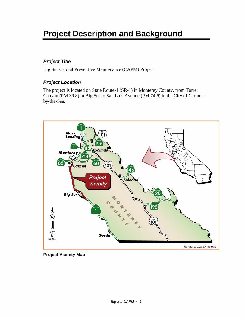
Project Description and Background
Project Title Big Sur Capital Preventive Maintenance (CAPM) Project
Project Location The project is located on State Route-1 (SR-1) in Monterey County, from Torre Canyon (PM 39.8) in Big Sur to San Luis Avenue (PM 74.6) in the City of Carmel-by-the-Sea.
Project Vicinity Map

Project Description and Background
Big Sur CAPM 2
Project Location Map
Description of Project Caltrans is proposing to overlay approximately 35 miles of existing roadway on SR-1 from postmile 39.8 in Big Sur to postmile 74.6 in Carmel-by-the-Sea. The project intends to extend the service life and improve the ride quality of the existing roadway.
The existing pavement is showing signs of deterioration which is negatively affecting the ride quality of the roadway and is expected to continue to deteriorate if not appropriately addressed.
To address this problem, Caltrans proposes to overlay the existing roadway with 0.15 feet of dense graded Rubberized Hot Mixed Asphalt (RHMA-G). Cold planing of the existing roadway will be required in some locations to maintain the original grade of the highway. Asphalt bridge approaches will be ground down and repaved with overlay to match the existing roadway surface on the bridge deck. Bridge decks with existing asphalt surfaces will be ground down to a depth of 0.15 feet and repaved with overlay. Bridge decks with concrete roadway surfaces will not be ground down or paved with overlay. At locations where pavement failure has been identified, the roadway will be removed to a depth of 0.33 feet and restored with Hot Mixed Asphalt (HMA) Type A before the area is repaved with overlay.

Project Description and Background
Big Sur CAPM 3
The existing asphalt dikes will be removed and replaced. Drainage inlets along the project will be adjusted to match the new overlay grade as necessary. Any existing Traffic Monitoring Systems (TMS) and utility covers within the project limits will also be adjusted to take the new overlay grade into account.
Asphalt overlay pavement edge treatments and shoulder backing will be constructed. Shoulder backing will be placed at feasible locations throughout the project limits to prevent the new road edge from premature failure as well as reduce incidents of pavement edge drop-off. Shoulder backing will not extend more than two feet from edge of existing pavement. Shoulder backing will be constructed of compacted loose materials (recycled asphalt pavement, clean material, etc.) and will not be paved over. Shoulder backing that may be placed within 100 horizontal feet of a culvert, watercourse, or bridge shall be constructed of crushed gravel or stone and will not use any type of materials containing asphalt.
In addition, centerline rumble strips will be considered throughout the project limits and will be installed during construction when appropriate.
The project also proposes to incorporate several enhancements to improve roadway safety and pedestrian access:
1. Upgrading the existing Metal Beam Guardrail (MGBR) to Midwest Guardrail System (MGS) where the existing MBGR cannot be raised to a height of 29 inches above the roadway surface. Only existing MGBR will be adjusted or upgraded. The project will not install guardrail where there is no existing guardrail in place. The new MGS will be attached to an anchor post or transitioned to the existing guardrail bridge attachments and end post. No modifications will be made to historic structures or walls.
2. Upgrade the pedestrian curb ramps at Ocean Avenue in Carmel-by-the-Sea at postmile 73.8. Two ramps will be installed on the pedestrian island at the northwest corner of the intersection to compliment recently installed ADA ramps in the south west, south east and north east corner.
3. Within the project limits, all warning signs will be removed and replaced with signs made with Type 11 retroreflective sheeting and all regulatory signs will be removed and replaced with signs made with Type 9 retroreflective sheeting. Only existing signs will be replaced and no additional signs will be installed.
Project Description and Background
Big Sur CAPM 4
The project will occur within Caltrans right-of-way and is not intended to modify the existing roadway geometry or capacity. The project will require one-way lane closures and may require night work as part of the construction process.
The estimated construction cost is approximately $21,210,000.
The estimated construction time is approximately 150 working days.
Surrounding Lands Uses and Setting Within the project limits, SR-1 is a two-lane conventional highway from postmile 39.8 to postmile 72.8 and expands to a four-lane conventional highway from postmile 72.8 to 74.6. The traffic lane width varies between 10 to 12 feet wide. Paved outside shoulder width also varies between zero to eight feet wide at certain locations, with a majority being four feet or less. Multiple turnouts and rest areas are present along SR-1 within the region.
The project stretches between Carmel and the Big Sur region, and is within the Carmel – San Simeon Highway Historic District. The region around Carmel is urban with homes and businesses located adjacent to SR-1. The Big Sur region is considered rural with homes, public space, and business sporadically spread along SR-1. Both regions are popular tourist destinations and are visited year-round. Carmel and the Big Sur region are located along the California coast, with SR-1 winding through western slopes of the Santa Lucia Mountains. The region as whole contains a variety of geological features, natural abundance, recreational opportunities, and unique viewscapes.
The project is located within an area included in Monterey County’s Big Sur Coast Land Use Plan (BSCLUP). Within the Big Sur region, the BSCLUP provides development standards to guide actions of all State and local agencies. The plan has been prepared to carry out the requirements of the California Coastal Act of 1976 as the primary component of a certified Local Coastal Program (LCP) that has been approved by the California Coastal Commission (CCC). The Coastal Act places emphasis on environmental protection and public recreation which were important considerations when formulating the plan. Within the basic objectives and policies of the BSCLUP, SR-1 is discussed as a special road of great local, state, and national significance. The basic policy is to take a strong and active role in guiding future use and improvement of SR-1 and all categories of land use related to and dependent on SR-1. The purpose of the plan will be to maintain and enhance the highway’s aesthetic beauty and to protect its primary function as a recreational route. It is intended that the highway shall remain a two-lane road and provide walking and bike trails wherever feasible.
Project Description and Background
Big Sur CAPM 5
The project is also located within the Big Sur Coast Highway Management Plan (BSCHMP) area. The 2004 BSCHMP is the result of collaboration between the Federal Highway Administration and Caltrans. A large amount of stakeholder and community input was used to develop the plan. The plan addresses several aspects of the Big Sur region such as: Corridor Aesthetics, Landslide Management & Storm Damage Response, and Vegetation Management. The plan provides the framework for ongoing collaboration to meet stakeholder’s common vision for the corridor.
Other Public Agencies Whose Approval is Required The following permits, review and approvals would be required for project construction.
Agency Permit/Approval Status
U.S. Fish and Wildlife Service
Programmatic Biological Opinions for Smith Blue Butterfly
and California red-legged frog
Obtained concurrence for use of Programmatic
Biological Opinion
Monterey County Coastal Development Permit (CDP)
Project may be exempt from a CDP. Will require further coordination after
project approval.

Project Description and Background
Big Sur CAPM 6
This page left intentionally blank

CEQA Environmental Checklist
Big Sur CAPM 7
CEQA Environmental Checklist
PROJECT DESCRIPTION AND BACKGROUND
Project Title: Big Sur CAPM Project Lead agency name and address: Caltrans, 50 Higuera Street, San Luis
Obispo CA, 93401 Contact person and phone number: Matt Fowler, 805-542-4603 Project Location: Monterey County Project sponsor’s name and address: Caltrans General plan description: Capital Preventive Maintenance Program
(CAPM) Zoning: Coastal Zone Description of project: (Describe the whole action involved, including but not limited to later phases of the project, and any secondary, support, or off-site features necessary for its implementation.)
Caltrans proposes to overlay the existing roadway on SR-1 in the Big Sur region. The
project will occur within Caltrans right-of-way and is not intended to modify the
existing roadway geometry or capacity. The project will require lane closures and may
require night work as part of the construction process.
Surrounding land uses and setting; briefly describe the project’s surroundings:
The project stretches between Carmel and the Big Sur region, and is within the Carmel
– San Simeon Highway Historic District. Other public agencies whose approval is required (e.g. permits, financial approval, or participation agreements):
U.S. Fish and Wildlife Service, Ventura Office
Have California Native American tribes traditionally and culturally affiliated with the project area requested consultation pursuant to Public Resources Code section 21080.3.1? If so, has consultation begun? Note: Conducting consultation early in the CEQA process allows tribal governments, lead agencies, and project proponents to discuss the level of environmental review, identify and address potential adverse impacts to tribal cultural resources, and reduce the potential for delay and conflict in the environmental review process. (See Public Resources Code section 21083.3.2.) Information may also be available from the California Native American Heritage Commission’s Sacred Lands File per Public Resources Code section 5097.96 and the California Historical Resources Information System administered by the California Office of Historic Preservation. Please also note that Public Resources Code section 21082.3(c) contains provisions specific to confidentiality.
Letters and emails have been sent regarding the project’s offering for
consultation under the PRC 21080.3.1 (AB 52). No Consultation has been requested
at this time.

CEQA Environmental Checklist
Big Sur CAPM 8
This page left intentionally blank

CEQA Environmental Checklist
Big Sur CAPM 9
CEQA Environmental Checklist 05-MON-01 39.8/74.6 05-1F680 Dist.-Co.-Rte. P.M/P.M. E.A. This checklist identifies physical, biological, social and economic factors that might be affected by the proposed project. In many cases, background studies performed in connection with the projects indicate no impacts. A NO IMPACT answer in the last column reflects this determination. Where there is a need for clarifying discussion, the discussion is included either following the applicable section of the checklist or is within the body of the environmental document itself. The words "significant" and "significance" used throughout the following checklist are related to CEQA, not NEPA, impacts. The questions in this form are intended to encourage the thoughtful assessment of impacts and do not represent thresholds of significance.
Potentially
Significant Impact
Less Than Significant with Mitigation
Less Than Significant Impact
No Impact
I. AESTHETICS: Would the project:
a) Have a substantial adverse effect on a scenic vista?
b) Substantially damage scenic resources, including, but not limited to, trees, rock outcroppings, and historic buildings within a state scenic highway?
c) Substantially degrade the existing visual character or quality of the site and its surroundings?
d) Create a new source of substantial light or glare which would adversely affect day or nighttime views in the area?
II. AGRICULTURE AND FOREST RESOURCES: In determining whether impacts to agricultural resources are significant environmental effects, lead agencies may refer to the California Agricultural Land Evaluation and Site Assessment Model (1997) prepared by the California Dept. of Conservation as an optional model to use in assessing impacts on agriculture and farmland. In determining whether impacts to forest resources, including timberland, are significant environmental effects, lead agencies may refer to information compiled by the California Department of Forestry and Fire Protection regarding the state’s inventory of forest land, including the Forest and Range Assessment Project and the Forest Legacy Assessment Project; and the forest carbon measurement methodology provided in Forest Protocols adopted by the California Air Resources Board. Would the project:
a) Convert Prime Farmland, Unique Farmland, or Farmland of Statewide Importance (Farmland), as shown on the maps prepared pursuant to the Farmland Mapping and Monitoring Program of the California Resources Agency, to non-agricultural use?

CEQA Environmental Checklist
Big Sur CAPM 10
Potentially Significant Impact
Less Than Significant with Mitigation
Less Than Significant Impact
No Impact
c) Conflict with existing zoning for, or cause rezoning of, forest land (as defined in Public Resources Code section 12220(g)), timberland (as defined by Public Resources Code section 4526), or timberland zoned Timberland Production (as defined by Government Code section 51104(g))?
d) Result in the loss of forest land or conversion of forest land to non-forest use?
e) Involve other changes in the existing environment which, due to their location or nature, could result in conversion of Farmland, to non-agricultural use or conversion of forest land to non-forest use?
III. AIR QUALITY: Where available, the significance criteria established by the applicable air quality management or air pollution control district may be relied upon to make the following determinations. Would the project:
a) Conflict with or obstruct implementation of the applicable air quality plan?
b) Violate any air quality standard or contribute substantially to an existing or projected air quality violation?
c) Result in a cumulatively considerable net increase of any criteria pollutant for which the project region is non- attainment under an applicable federal or state ambient air quality standard (including releasing emissions which exceed quantitative thresholds for ozone precursors)?
d) Expose sensitive receptors to substantial pollutant concentrations?
e) Create objectionable odors affecting a substantial number of people?
IV. BIOLOGICAL RESOURCES: Would the project:
a) Have a substantial adverse effect, either directly or through habitat modifications, on any species identified as a candidate, sensitive, or special status species in local or regional plans, policies, or regulations, or by the California Department of Fish and Game or U.S. Fish and Wildlife Service?
b) Have a substantial adverse effect on any riparian habitat or other sensitive natural community identified in local or regional plans, policies, regulations or by the California Department of Fish and Game or US Fish and Wildlife Service?
CEQA Environmental Checklist
Big Sur CAPM 11
Potentially Significant Impact
Less Than Significant with Mitigation
Less Than Significant Impact
No Impact
c) Have a substantial adverse effect on federally protected wetlands as defined by Section 404 of the Clean Water Act (including, but not limited to, marsh, vernal pool, coastal, etc.) through direct removal, filling, hydrological interruption, or other means?
d) Interfere substantially with the movement of any native resident or migratory fish or wildlife species or with established native resident or migratory wildlife corridors, or impede the use of native wildlife nursery sites?
e) Conflict with any local policies or ordinances protecting biological resources, such as a tree preservation policy or ordinance?
f) Conflict with the provisions of an adopted Habitat Conservation Plan, Natural Community Conservation Plan, or other approved local, regional, or state habitat conservation plan?
V. CULTURAL RESOURCES: Would the project:
a) Cause a substantial adverse change in the significance of a historical resource as defined in §15064.5?
b) Cause a substantial adverse change in the significance of an archaeological resource pursuant to §15064.5?
c) Directly or indirectly destroy a unique paleontological resource or site or unique geologic feature?
d) Disturb any human remains, including those interred outside of dedicated cemeteries?
VI. GEOLOGY AND SOILS: Would the project:
a) Expose people or structures to potential substantial adverse effects, including the risk of loss, injury, or death involving:
i) Rupture of a known earthquake fault, as delineated on the most recent Alquist-Priolo Earthquake Fault Zoning Map issued by the State Geologist for the area or based on other substantial evidence of a known fault? Refer to Division of Mines and Geology Special Publication 42?
ii) Strong seismic ground shaking?
iii) Seismic-related ground failure, including liquefaction?
CEQA Environmental Checklist
Big Sur CAPM 12
Potentially Significant Impact
Less Than Significant with Mitigation
Less Than Significant Impact
No Impact
iv) Landslides?
b) Result in substantial soil erosion or the loss of topsoil?
c) Be located on a geologic unit or soil that is unstable, or that would become unstable as a result of the project, and potentially result in on- or off-site landslide, lateral spreading, subsidence, liquefaction or collapse?
d) Be located on expansive soil, as defined in Table 18-1-B of the Uniform Building Code (1994), creating substantial risks to life or property?
e) Have soils incapable of adequately supporting the use of septic tanks or alternative waste water disposal systems where sewers are not available for the disposal of waste water?
VII. GREENHOUSE GAS EMISSIONS: Would the project:
a) Generate greenhouse gas emissions, either directly or indirectly, that may have a significant impact on the environment?
Caltrans has used the best available information based to the extent possible on scientific and factual information, to describe, calculate, or estimate the amount of greenhouse gas emissions that may occur related to this project. The analysis included in the climate change section of this document provides the public and decision-makers as much information about the project as possible. It is Caltrans’ determination that in the absence of statewide-adopted thresholds or GHG emissions limits, it is too speculative to make a significance determination regarding an individual project’s direct and indirect impacts with respect to global climate change. Caltrans remains committed to implementing measures to reduce the potential effects of the project. These measures are outlined in the climate change section of the document.
b) Conflict with an applicable plan, policy or regulation adopted for the purpose of reducing the emissions of greenhouse gases?
VIII. HAZARDS AND HAZARDOUS MATERIALS: Would the project:
a) Create a significant hazard to the public or the environment through the routine transport, use, or disposal of hazardous materials?
b) Create a significant hazard to the public or the environment through reasonably foreseeable upset and accident conditions involving the release of hazardous materials into the environment?
c) Emit hazardous emissions or handle hazardous or acutely hazardous materials, substances, or waste within one-quarter mile of an existing or proposed school?
CEQA Environmental Checklist
Big Sur CAPM 13
Potentially Significant Impact
Less Than Significant with Mitigation
Less Than Significant Impact
No Impact
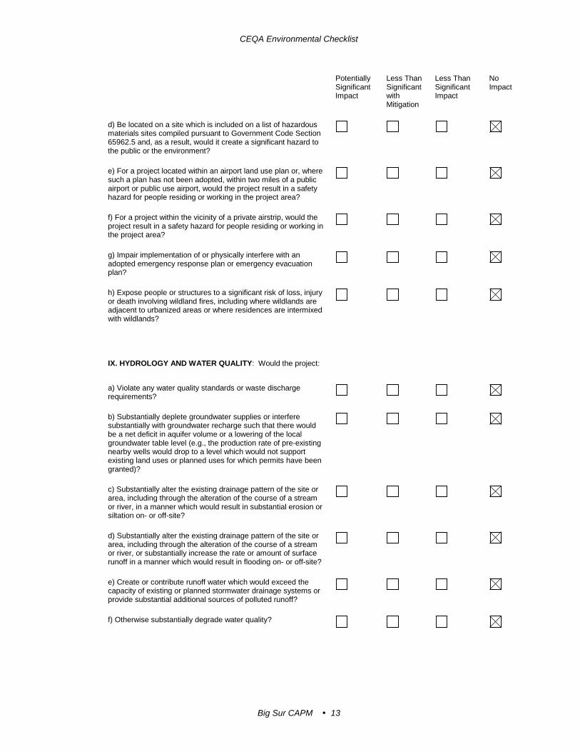
d) Be located on a site which is included on a list of hazardous materials sites compiled pursuant to Government Code Section 65962.5 and, as a result, would it create a significant hazard to the public or the environment?
e) For a project located within an airport land use plan or, where such a plan has not been adopted, within two miles of a public airport or public use airport, would the project result in a safety hazard for people residing or working in the project area?
f) For a project within the vicinity of a private airstrip, would the project result in a safety hazard for people residing or working in the project area?
g) Impair implementation of or physically interfere with an adopted emergency response plan or emergency evacuation plan?
h) Expose people or structures to a significant risk of loss, injury or death involving wildland fires, including where wildlands are adjacent to urbanized areas or where residences are intermixed with wildlands?
IX. HYDROLOGY AND WATER QUALITY: Would the project:
a) Violate any water quality standards or waste discharge requirements?
b) Substantially deplete groundwater supplies or interfere substantially with groundwater recharge such that there would be a net deficit in aquifer volume or a lowering of the local groundwater table level (e.g., the production rate of pre-existing nearby wells would drop to a level which would not support existing land uses or planned uses for which permits have been granted)?
c) Substantially alter the existing drainage pattern of the site or area, including through the alteration of the course of a stream or river, in a manner which would result in substantial erosion or siltation on- or off-site?
d) Substantially alter the existing drainage pattern of the site or area, including through the alteration of the course of a stream or river, or substantially increase the rate or amount of surface runoff in a manner which would result in flooding on- or off-site?
e) Create or contribute runoff water which would exceed the capacity of existing or planned stormwater drainage systems or provide substantial additional sources of polluted runoff?
f) Otherwise substantially degrade water quality?

CEQA Environmental Checklist
Big Sur CAPM 14
Potentially Significant Impact
Less Than Significant with Mitigation
Less Than Significant Impact
No Impact
g) Place housing within a 100-year flood hazard area as mapped on a federal Flood Hazard Boundary or Flood Insurance Rate Map or other flood hazard delineation map?
h) Place within a 100-year flood hazard area structures which would impede or redirect flood flows?
i) Expose people or structures to a significant risk of loss, injury or death involving flooding, including flooding as a result of the failure of a levee or dam?
j) Inundation by seiche, tsunami, or mudflow
X. LAND USE AND PLANNING: Would the project:
a) Physically divide an established community?
b)Conflict with any applicable land use plan, policy, or regulation of an agency with jurisdiction over the project (including, but not limited to the general plan, specific plan, local coastal program, or zoning ordinance) adopted for the purpose of avoiding or mitigating an environmental effect?
c) Conflict with any applicable habitat conservation plan or natural community conservation plan?
XI. MINERAL RESOURCES: Would the project:
a) Result in the loss of availability of a known mineral resource that would be of value to the region and the residents of the state?
b) Result in the loss of availability of a locally-important mineral resource recovery site delineated on a local general plan, specific plan or other land use plan?
XII. NOISE: Would the project result in:
a) Exposure of persons to or generation of noise levels in excess of standards established in the local general plan or noise ordinance, or applicable standards of other agencies?
b) Exposure of persons to or generation of excessive groundborne vibration or groundborne noise levels?
c) A substantial permanent increase in ambient noise levels in the project vicinity above levels existing without the project?

CEQA Environmental Checklist
Big Sur CAPM 15
Potentially Significant Impact
Less Than Significant with Mitigation
Less Than Significant Impact
No Impact
d) A substantial temporary or periodic increase in ambient noise levels in the project vicinity above levels existing without the project?
e) For a project located within an airport land use plan or, where such a plan has not been adopted, within two miles of a public airport or public use airport, would the project expose people residing or working in the project area to excessive noise levels?
f) For a project within the vicinity of a private airstrip, would the project expose people residing or working in the project area to excessive noise levels?
XIII. POPULATION AND HOUSING: Would the project:
a) Induce substantial population growth in an area, either directly (for example, by proposing new homes and businesses) or indirectly (for example, through extension of roads or other infrastructure)?
b) Displace substantial numbers of existing housing, necessitating the construction of replacement housing elsewhere?
c) Displace substantial numbers of people, necessitating the construction of replacement housing elsewhere?
XIV. PUBLIC SERVICES:
a) Would the project result in substantial adverse physical impacts associated with the provision of new or physically altered governmental facilities, need for new or physically altered governmental facilities, the construction of which could cause significant environmental impacts, in order to maintain acceptable service ratios, response times or other performance objectives for any of the public services:
Fire protection?
Police protection?
Schools?
Parks?
Other public facilities?

CEQA Environmental Checklist
Big Sur CAPM 16
Potentially Significant Impact
Less Than Significant with Mitigation
Less Than Significant Impact
No Impact
XV. RECREATION:
a) Would the project increase the use of existing neighborhood and regional parks or other recreational facilities such that substantial physical deterioration of the facility would occur or be accelerated?
b) Does the project include recreational facilities or require the construction or expansion of recreational facilities which might have an adverse physical effect on the environment?
XVI. TRANSPORTATION/TRAFFIC: Would the project:
a) Conflict with an applicable plan, ordinance or policy establishing measures of effectiveness for the performance of the circulation system, taking into account all modes of transportation including mass transit and non-motorized travel and relevant components of the circulation system, including but not limited to intersections, streets, highways and freeways, pedestrian and bicycle paths, and mass transit?
b) Conflict with an applicable congestion management program, including, but not limited to level of service standards and travel demand measures, or other standards established by the county congestion management agency for designated roads or highways?
c) Result in a change in air traffic patterns, including either an increase in traffic levels or a change in location that results in substantial safety risks?
d) Substantially increase hazards due to a design feature (e.g., sharp curves or dangerous intersections) or incompatible uses (e.g., farm equipment)?
e) Result in inadequate emergency access?
f) Conflict with adopted policies, plans or programs regarding public transit, bicycle, or pedestrian facilities, or otherwise decrease the performance or safety of such facilities?
XVII. TRIBAL CULTURAL RESOURCES: Would the project cause a substantial adverse change in the significance of a tribal cultural resource, defined in Public Resources Code section 21074 as either a site, feature, place, cultural landscape that is geographically defined in terms of the size and scope of the landscape, sacred place, or object with cultural value to a California Native American tribe, and that is:
a) Listed or eligible for listing in the California Register of Historical Resources, or in a local register of historical resources as defined in Public Resources Code section 5020.1(k), or

CEQA Environmental Checklist
Big Sur CAPM 17
Potentially
Significant Impact
Less Than Significant with Mitigation
Less Than Significant Impact
No Impact
b) A resource determined by the lead agency, in its discretion and supported by substantial evidence, to be significant pursuant to criteria set forth in subdivision (c) of Public Resources Code Section 5024.1. In applying the criteria set forth in subdivision (c) of Public Resource Code Section 5024.1, the lead agency shall consider the significance of the resource to a California Native American tribe.
XVIII. UTILITIES AND SERVICE SYSTEMS: Would the project:
a) Exceed wastewater treatment requirements of the applicable Regional Water Quality Control Board?
b) Require or result in the construction of new water or wastewater treatment facilities or expansion of existing facilities, the construction of which could cause significant environmental effects?
c) Require or result in the construction of new storm water drainage facilities or expansion of existing facilities, the construction of which could cause significant environmental effects?
d) Have sufficient water supplies available to serve the project from existing entitlements and resources, or are new or expanded entitlements needed?
e) Result in a determination by the wastewater treatment provider which serves or may serve the project that it has adequate capacity to serve the project’s projected demand in addition to the provider’s existing commitments?
f) Be served by a landfill with sufficient permitted capacity to accommodate the project’s solid waste disposal needs?
g) Comply with federal, state, and local statutes and regulations related to solid waste?

CEQA Environmental Checklist
Big Sur CAPM 18
Potentially Significant Impact
Less Than Significant with Mitigation
Less Than Significant Impact
No Impact
XIX. MANDATORY FINDINGS OF SIGNIFICANCE
a) Does the project have the potential to degrade the quality of the environment, substantially reduce the habitat of a fish or wildlife species, cause a fish or wildlife population to drop below self-sustaining levels, threaten to eliminate a plant or animal community, substantially reduce the number or restrict the range of a rare or endangered plant or animal or eliminate important examples of the major periods of California history or prehistory?
b) Does the project have impacts that are individually limited, but cumulatively considerable? ("Cumulatively considerable" means that the incremental effects of a project are considerable when viewed in connection with the effects of past projects, the effects of other current projects, and the effects of probable future projects)?
c) Does the project have environmental effects which will cause substantial adverse effects on human beings, either directly or indirectly?

Big Sur CAPM 19
Additional Explanations for Questions in the CEQA Checklist
I. Aesthetics (c)
Affected Environment
State Route-1 in Monterey County is designated as an Official State Scenic Highway, a National Scenic Byway and an All-American Road. It serves local and interregional traffic which primarily includes, local commuters, and limited commercial users. State Route-1 has long been recognized for its scenic qualities, and the state and national scenic designations illustrate the heightened degree of sensitivity concerning the aesthetic character of the highway.
Monterey County planning policies emphasize the protection of visual resources along SR-1 and underscore the concern and sensitivity regarding aesthetic issues along this route. The project is located within the Coastal Zone, which Monterey County places an emphasis on visual quality preservation. The Coast Highway Management Plan (Caltrans 2003), a comprehensive planning document developed with extensive community input, includes a section on identifying and preserving the scenic qualities of the route. The local community has a history of active participation in projects involving potential changes to the visual environment.
The project passes through several landscape types along its length. The landform of the region is generally characterized by steep slopes and ravines forming a series of ridgelines and valleys as the mountain rise from the Pacific Ocean. The topography supports a mostly curvilinear roadway which produces views for the highway traveler ranging from close-in views of the inland slopes to mid-range coastline views and wide open panoramas. Viewers along SR-1 are primarily in motor vehicles and are involved in a variety of activities, including recreation and tourism, local commuting, and limited service and commercial travel. Bicycle touring is also common within the project area. Pedestrian activity is common at the many formal and informal pullouts and vista points along the route as well as the more developed areas.
The existing scenic quality and character of the Big Sur Coast is based on a large degree on its undeveloped setting, rugged topography, sweeping ocean views, and native vegetation patterns.
Environmental Consequences
Roadside views along SR-1 within the project area are mostly limited to the fore-ground and mid-ground on the inland side of the road and mid to long distance views towards the ocean. The project has the potential to result in noticeable changes to the existing visual character at each guardrail and anchor block location. In general, the

Additional Explanations for Questions in the CEQA Checklist
Big Sur CAPM 20
most noticeable components of the project would be the new and replaced guardrail and the new end blocks. The fresh asphalt surfacing and shoulder backing would also be noticeable until such time that they weather and aged. These new built environments would also increase the perception of “visual clutter” along the Big Sur corridor and as such would not support the aesthetic values expressed in the Coast Highway Management Plan and other coastal planning documents. In most instances the noticeability of change would be increased by the visual contrast between the color and reflectivity of the new project elements and adjacent natural setting.
The groups most affected by the project are those who travel the highway, and off-roadway viewers in the immediate vicinity of the project. The project would be seen from recreational areas along the route. Formal and informal vista points, public beaches, access trails and campgrounds are located throughout the project limits. State Route-1 is classified as a designated bicycle route throughout the project limits. Pedestrians and bicyclist would have a greater visual exposure to the project components due proximity and slower pace of travel.
Measures specifically addressing this visual contrast issue would minimize noticeability of the individual project elements and would reduce its potential effect on the existing visual character.
Avoidance, Minimization and/or Mitigation
With the implementation of the following measures, the potential visual impacts of this project can be reduced and would not result in substantial adverse impacts to the existing visual environment:
1. Preserve as much existing vegetation as possible. Prescriptive clearing and grubbing and grading techniques which save the most existing vegetation shall be employed.
2. Revegetate all previously undisturbed construction staging areas with native plant species appropriate to each specific work location.
3. If vegetation control treatments are required, treatments shall utilize a pervious surface such as crushed shale. If shale is not feasible, the surface material should match the color of the adjacent dirt to the greatest extent possible. The specific color shall be determined by a Caltrans Landscape Architecture representative.
4. All concrete end blocks and transition rail should receive aesthetic treatment appropriate for the specific work location. The type of aesthetic treatment for these concrete elements shall be determined by a Caltrans Landscape Architecture representative in collaboration with the Project Engineer.
5. The post and beams of all new or replaced guardrail, metallic transitions, anchor posts and end sections shall be colored and/or darkened to blend with

Additional Explanations for Questions in the CEQA Checklist
Big Sur CAPM 21
the surroundings and reduce reflectivity. The specific color shall be determined by a Caltrans Landscape Architecture representative.
6. The post and beams of all existing guardrail within the project limits which is not replaced as part of this project shall be colored and/or darkened to blend with the surrounding and reduce reflectivity. The specific color shall be determined by a Caltrans Landscape Architecture representative.
IV. Biological Resources (a and b)
Natural Communities
This section of the document discusses natural communities of concern. The focus of this section is on biological communities, not individual plant or animal species.
Habitat areas that have been designated as critical habitat under the Federal Endangered Species Act are discussed below in the Threatened and Endangered Species section.
Affected Environment
The Natural Environmental Study – Minimal Impacts (NES-MI) was completed for the project in October 2017. As part of the study, a Biological Study Area (BSA) for the project was defined using the following criteria: the area that may directly, indirectly, temporarily, or permanently impacted by construction, construction-related activities, and vehicles. For the purposes of this project, the BSA is the largest total area where impacts may happen to natural communities/habitats within the project and includes potential disturbance area for both permanent impacts (installation of shoulder backing), temporary impacts, and indirect impacts. Caltrans design engineers determined the proposed Area of Potential Impact (API), where project activities could have a direct effect on the ground or vegetation. The API includes the paved roadway and an area of two feet from the edge of pavement where shoulder backing will be installed. A representative example of the two-foot-wide area at the edge of pavement where shoulder backing would be placed can be seen in Figure 1. The BSA includes the API and a five-foot buffer around the API to account for indirect impacts of the project.
The predominant vegetation communities/habitats present within the BSA are ruderal/disturbed and annual non-native grassland, but the BSA also includes coastal scrub, upland redwood forest, Monterey pine forest, Monterey cypress forest, and central dune scrub.

Additional Explanations for Questions in the CEQA Checklist
Big Sur CAPM 22
Figure 1 - Representative Example of the Two-Foot-Wide Area at the Edge of Pavement
Ruderal/Disturbed Ruderal/disturbed areas contain mainly non-native weedy and/or invasive species tolerant of disturbed conditions (e.g. compacted soils, roadsides subjected to vehicle disturbances, etc.). Invasive species were verified by the California Invasive Plant Council (Cal-IPC) database (Cal-IPC 2013). Invasive plant species such as Italian thistle (Carduus pycnocephalus), black mustard (Brassica nigra), and fennel (Foeniculum vulgare) dominate these areas. Invasive grasses include red brome (Bromus madritensis ssp. rubens), Italian ryegrass (Fescuta perennis), and foxtail barley (Hordeum murinum). Ruderal/disturbed areas within the BSA are found throughout the project areas where vehicle impacts and maintenance activities have impacted and compacted the unpaved shoulders along the margins of SR-1.
Annual Non-native Grassland Annual non-native grasslands occur throughout a large portion of California, primarily below 3,000-foot elevation on fine-textured, usually clay soils (Holland 1986). This vegetation type is dominated by introduced annual grasses in association with species of native and non-native forbs (herbaceous annual and perennial plants such as wildflowers), especially in years of abundant rainfall. Most annuals in this community die by summer and persist as seeds until the return of winter rains. Dominant species include introduced grasses such as wild oats (Avena barbata), ripgut brome (Bromus diandrus), soft chess brome (Bromus hordeaceus), and red

Additional Explanations for Questions in the CEQA Checklist
Big Sur CAPM 23
brome (Bromus madritensis ssp. rubens). Various annual forbs also occur as associate species, such as burclover (Medicago polymorpha) and western vervain (Verbena lasiostachys). Annual non-native grassland within the BSA can be found south of Point Sur.
Coastal Scrub Coastal scrub habitat in the project area is best characterized as Central Lucian Coastal Scrub (Holland 1986). Dominant species include black sage (Salvia mellifera), California sagebrush (Artemisia californica), coyote bush (Baccharis pilularis) and sticky monkeyflower (Diplacus [Mimulus] aurantiacus) with scattered annual grasses and forbs in between the shrub layer. This habitat is often found on steep slopes, mostly in the southern portion of the project limits. This habitat may have a sparse vegetative cover, and could also include golden yarrow (Eriophyllum confertiflorum), California bay (Umbellularia californica), Califonia brickellbush (Brickellia californica), and seacliff buckwheat (Eriogonum parvifolium). This vegetation community may support suitable habitat for the federally listed Smith’s blue butterfly, if seacliff buckwheat is present.
Upland Redwood Forest The upland redwood forest within the project area is described by Holland (1986) and is also consistent with the Sequoia sempervirens Forest Alliance (Sawyer et al. 2009). Coast redwood (Sequoia sempervirens) is the dominant species with California bay and big leaf maple (Acer macrophyllum) as associate species. This habitat is found just inland from the coast, in canyons and along upland areas of river and creek banks. Portions of the BSA, mainly from Big Sur to Andrew Molera State Park, contain upland redwood forest.
Monterey Pine Forest In the project area, Monterey pine forest as described by Holland (1986) is consistent with the Pinus radiata Alliance (Sawyer et al. 2009). The dominate species is Monterey pine (Pinus radiata) and naturally occurs on maritime terraces, headlands, and hillsides. Associated species include Monterey cypress (Hesperocyparis macrocarpa), coast live oak (Quercus agrifolia), Douglas fir (Pseudotsuga menziesii), and Madrone (Arbutus menziesi).
While Monterey pine is a California Rare Plant Rank (CRPR) 1B.1 species and the Pinus radiata Alliance is a natural community of special concern, the tree has been planted extensively in the region; only three native stands are considered rare as a species, or as a natural community of special concern. One of these native stands is located around the Point Lobos State Park area and occurs in a portion of the BSA, but others scattered along the BSA are trees that were planted/naturalized (USGS 1999; Critchfield and Little 1966). Furthermore, the Cal-IPC considers cultivars of Monterey pine to be an invasive species of limited concern (Cal-IPC 2013).

Additional Explanations for Questions in the CEQA Checklist
Big Sur CAPM 24
Monterey Cypress Forest Monterey cypress forest (Holland 1986) is similar to Hesperocyparis macrocarpa Woodland Special Stands as described by Sawyer et al. (2009). The dominant canopy cover is Monterey cypress (Hesperocyparis macrocarpa) and naturally occurs on headlands and sheltered areas near the coast. Associated species include Monterey pine and coast live oak. While Monterey cypress is a CRPR 1B.2 species and the Hesperocyparis macrocarpa unique stand is a natural community of special concern, the tree has been planted extensively in the region, especially for windrows. Only two native stands are considered rare as a species, or as a natural community of special concern. One of these native stands is located in the Point Lobos State Park area but does not occur in the BSA, and others scattered along the BSA are trees that were planted/naturalized (Thompson et al. 1999).
Central Dune Scrub This community is found along the coast on relatively stabilized back dune slopes, ridges, river bars and sand spits. It consists of low-growing, scattered shrubs, subshrubs, and herbs that may develop considerable cover over sandy soil. This habitat is consistent with the Dune Lupine-Goldenbush Series as described by Sawyer et al. (2009). Characteristic species include California goldenbush (Ericameria ericoides), Chamisso’s bush lupine or dune lupine (Lupinus chamissonis), coastal sagewort (Artemisia pycnocephala) and California aster (Symphyotrichum chilense). Central dune scrub intergrades with other coastal communities, such as central coastal scrub, northern foredunes, and coastal sage-chaparral scrub (Holland 1986).
Central dune scrub was observed within the study area south of the Little Sur River, but in a very disturbed condition and with invasive Hottentot fig (Carpobrotus edulis) (i.e. iceplant) encroaching and over-taking the community (See Figure 2).
Environmental Consequences
Impacts to natural communities/habitats within the BSA have been based on ground disturbance, temporary impacts and permanent impacts within the API.
The majority of the predominant vegetation communities/habitats present within the BSA are not found within the two-foot-wide API and would not be affected by the project.
Of the predominate vegetation communities/habitats present with the BSA, two of them are California Department of Fish and Wildlife (CDFW) natural communities of special concern. The two identified communities/habitats are Monterey pine forest and central dune scrub.

Additional Explanations for Questions in the CEQA Checklist
Big Sur CAPM 25
Figure 2 - Example of Central Dune Scrub Affected by Iceplant
Monterey Pine Forest Native stands of Monterey pine forest occur in the BSA near Point Lobos State Park (between postmiles 68.6 and 70.6) and at this location approximately six Monterey pines are within the API.
Central Dune Scrub Central dune scrub was observed within the BSA south of the Little Sur River between postmile 55.3 and 55.8, and a small amount was found growing in the two-foot-wide API. Central dune scrub at this location exists as less than 40 percent of the total vegetation cover. Invasive Hottentot fig (iceplant) is more than 60 percent of the total vegetation cover and is slowly over-taking the native scrub. Central dune scrub is a CDFW natural community of special concern, but is not of high quality or abundant in the BSA at this location. The central dune scrub habitat within the API did not contain any listed or rare plant species. A rough estimate of 500 square feet of this central dune scrub will be removed to install shoulder backing.

Additional Explanations for Questions in the CEQA Checklist
Big Sur CAPM 26
Avoidance, Minimization and/or Mitigation
Monterey Pine Forest Trees found within the two-foot-wide API will not be removed. Shoulder backing material will not be composed of recycled asphalt pavement (RAP) when placed around trees. No impacts will occur to trees as a result of this project and no additional measures are needed to protect Monterey pine forest.
Central Dune Scrub No measures shall be implemented for Central dune scrub. The current habitat is of low quality due to periodic disturbances from vehicles and abundance of invasive exotic plant species. Due to the repeated impacts to this habitat from vehicles and invasive species, it is not likely to be considered especially valuable as it is already disturbed and degraded by human activities.
Plant Species
Affected Environment
Information in this section is based on the NES-MI prepared for this project in October 2017. Although suitable habitat exists in the BSA for 44 special-status plant species identified in the literature search, only Monterey pine was found within the BSA during appropriately timed surveys.
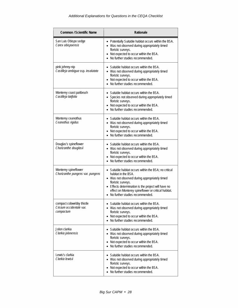
A summary of special-status plant species considered is presented in Table 1.

Additional Explanations for Questions in the CEQA Checklist
Big Sur CAPM 27
Table 1 - Summary of Special-Status Plant Species
Common / Scientific Name Rationale
bristlecone fir Abies bracteata
• Suitable habitat occurs within the BSA. • Was not observed during appropriately timed
floristic surveys. • Not expected to occur within the BSA. • No further studies recommended.
Hickman’s onion Allium hickmanii
• Suitable habitat occurs within the BSA. • Was not observed during appropriately timed
floristic surveys. • Not expected to occur within the BSA. • No further studies recommended.
Little Sur manzanita Arctostaphylos edmundsii
• Suitable habitat occurs within the BSA. • No manzanitas were observed in the BSA. • Not expected to occur within the BSA. • No further studies recommended.
Hooker’s manzanita Arctostaphylos hookeri ssp. hookeri
• Suitable habitat occurs within the BSA. • No manzanitas were observed in the BSA. • Not expected to occur within the BSA. • No further studies recommended.
Toro manzanita Arctostaphylos montereyensis
• Suitable habitat occurs within the BSA. • No manzanitas were observed in the BSA. • Not expected to occur within the BSA. • No further studies recommended.
sandmat manzanita Arctostaphylos pumila
• Potentially suitable habitat occurs within the BSA. • No manzanitas were observed in the BSA. • Not expected to occur within the BSA. • No further studies recommended.
marsh sandwort Arenaria paludicola
• The BSA does not occur within or directly adjacent to freshwater marshes or swamps and is not suitable for the species.
• Effects determination is the project will have no effect on marsh sandwort.
• No further studies recommended.
coastal dunes milk-vetch Astragalus tener var. titi
• Potentially suitable habitat occurs within the BSA. • Was not observed during appropriately timed
floristic surveys. • Effects determination is the project will have no
effect on coastal dunes milk-vetch. • No further studies recommended.
twisted horsehair lichen Bryoria spiralifera
• Potentially suitable habitat occurs in conifers that may be present within the BSA.
• No trees will be impacted by the project. • No further studies recommended.
Additional Explanations for Questions in the CEQA Checklist
Big Sur CAPM 28
Common / Scientific Name Rationale
San Luis Obispo sedge Carex obispoensis
• Potentially Suitable habitat occurs within the BSA. • Was not observed during appropriately timed
floristic surveys. • Not expected to occur within the BSA. • No further studies recommended.
pink johnny-nip Castilleja ambigua ssp. insalutata
• Suitable habitat occurs within the BSA. • Was not observed during appropriately timed
floristic surveys. • Not expected to occur within the BSA. • No further studies recommended.
Monterey coast paitbrush Castilleja latifolia
• Suitable habitat occurs within the BSA. • Species not observed during appropriately timed
floristic surveys. • Not expected to occur within the BSA. • No further studies recommended.
Monterey ceanothus Ceanothus rigidus
• Suitable habitat occurs within the BSA. • Was not observed during appropriately timed
floristic surveys. • Not expected to occur within the BSA. • No further studies recommended.
Douglas's spineflower Chorizanthe douglasii
• Suitable habitat occurs within the BSA. • Was not observed during appropriately timed
floristic surveys. • Not expected to occur within the BSA. • No further studies recommended.
Monterey spineflower Chorizanthe pungens var. pungens
• Suitable habitat occurs within the BSA; no critical habitat in the BSA.
• Was not observed during appropriately timed floristic surveys.
• Effects determination is the project will have no effect on Monterey spineflower or critical habitat.
• No further studies recommended.
compact cobwebby thistle Cirsium occidentale var. compactum
• Suitable habitat occurs within the BSA. • Was not observed during appropriately timed
floristic surveys. • Not expected to occur within the BSA. • No further studies recommended.
Jolon clarkia Clarkia jolonensis
• Suitable habitat occurs within the BSA. • Was not observed during appropriately timed
floristic surveys. • Not expected to occur within the BSA. • No further studies recommended.
Lewis's clarkia Clarkia lewisii
• Suitable habitat occurs within the BSA. • Was not observed during appropriately timed
floristic surveys. • Not expected to occur within the BSA. • No further studies recommended.

Additional Explanations for Questions in the CEQA Checklist
Big Sur CAPM 29
Common / Scientific Name Rationale
San Francisco collinsia Collinsia multicolor
• Suitable habitat occurs within the BSA. • Was not observed during appropriately timed
floristic surveys. • Not expected to occur within the BSA. • No further studies recommended.
seaside bird's-beak Cordylanthus rigidus ssp. littoralis
• Suitable habitat occurs within the BSA. • Was not observed during appropriately timed
floristic surveys. • Not expected to occur within the BSA. • No further studies recommended.
tear drop moss Dacryophyllum falcifolium
• The BSA is not suitable for this species due to regular impacts from vehicles
• Not observed in the BSA. • Not expected to occur within the BSA. • No further studies recommended.
Hutchinson's larkspur Delphinium hutchinsoniae
• Suitable habitat occurs within the BSA. • Was not observed during appropriately timed
floristic surveys. • Not expected to occur within the BSA. • No further studies recommended.
umbrella larkspur Delphinium umbraculorum
• No suitable habitat occurs within the BSA, which is also below the elevation range for the taxon.
• No further studies recommended.
Eastwood's goldenbush Ericameria fasciculata
• Suitable habitat occurs within the BSA. • Was not observed during appropriately timed
floristic surveys. • Not expected to occur within the BSA. • No further studies recommended.
Pinnacles buckwheat Eriogonum nortonii
• Grassland habitat occurs within the BSA, but is below the elevation range for the taxon.
• No further studies recommended.
Menzies’ wallflower Erysimum menziesii
• Potentially suitable habitat occurs within the BSA. • Was not observed during appropriately timed
floristic surveys. • Effects determination is the project will have no
effect on Menzies’ wallflower. • No further studies recommended.
fragrant fritillary Fritillaria liliacea
• Suitable habitat occurs within the BSA. • Was not observed during appropriately timed
floristic surveys. • Not expected to occur within the BSA. • No further studies recommended.
Cone Peak bedstraw Galium californicum ssp. luciense
• The BSA is below the elevation range for the taxon. • No further studies recommended.

Additional Explanations for Questions in the CEQA Checklist
Big Sur CAPM 30
Common / Scientific Name Rationale
Santa Lucia bedstraw Galium clementis
• No suitable habitat occurs within the BSA, because the BSA is below the elevation range for the taxon
• No further studies recommended.
Monterey gilia Gilia tenuiflora ssp. arenaria
• Suitable habitat occurs within the BSA. • Was not observed during appropriately timed
floristic surveys. • Effects determination is the project will have no
effect on Monterey gilia. • No further studies recommended.
Toren's grimmia Grimmia torenii
• No suitable habitat occurs within the BSA, which is also below the elevation range for the taxon.
• No further studies recommended.
Gowen cypress Hesperocyparis goveniana formerly Cupressus goveniana ssp. goveniana
• Potentially suitable habitat occurs within the BSA. • Was not observed during appropriately timed
floristic surveys. • Effects determination is the project will have no
effect on Gowen cypress • No further studies recommended.
Monterey cypress Hesperocyparis macrocarpa formerly Cupressus macrocarpa
• Suitable habitat occurs within the BSA. • Species observed in the BSA during floristic survey
are not native stands of Monterey cypress (Thompson et al. 1999)
• No trees will be impacted as a result of this project • No further studies recommended.
Kellogg's horkelia Horkelia cuneata ssp. sericea
• Suitable habitat occurs within the BSA. • Was not observed during appropriately timed
floristic surveys. • Not expected to occur within the BSA. • No further studies recommended.
beach layia Layia carnosa
• Suitable habitat occurs within the BSA. • Was not observed during appropriately timed
floristic surveys. • Effects determination is the project will have no
effect on beach layia. • No further studies recommended.
Tidestrom's lupine Lupinus tidestromii
• Potentially suitable habitat occurs within the BSA. • Was not observed during appropriately timed
floristic surveys. • Effects determination is the project will have no
effect on Tidestrom's lupine. • No further studies recommended.
Carmel Valley bush-mallow Malacothamnus palmeri var. involucratus
• Suitable habitat occurs within the BSA. • Was not observed during appropriately timed
floristic surveys. • Not expected to occur within the BSA. • No further studies recommended.

Additional Explanations for Questions in the CEQA Checklist
Big Sur CAPM 31
Common / Scientific Name Rationale
Arroyo Seco bush-mallow Malacothamnus palmeri var. lucianus
• Suitable habitat occurs within the BSA. • Was not observed during appropriately timed
floristic surveys. • Not expected to occur within the BSA. • No further studies recommended.
Carmel Valley malacothrix saxatilis var. arachnoidea
• Suitable habitat occurs within the BSA. • Was not observed during appropriately timed
floristic surveys. • Not expected to occur within the BSA. • No further studies recommended.
marsh microseris Microseris paludosa
• Suitable habitat occurs within the BSA. • Was not observed during appropriately timed
floristic surveys. • Not expected to occur within the BSA. • No further studies recommended.
northern curly-leaved monardella sinuata ssp. nigrescens
• Suitable habitat occurs within the BSA. • Was not observed during appropriately timed
floristic surveys. • Not expected to occur within the BSA. • No further studies recommended.
woodland woollythreads Monolopia gracilens
• Potentially suitable habitat occurs within the BSA. • Was not observed during appropriately timed
floristic surveys. • Not expected to occur within the BSA. • No further studies recommended.
Dudley's lousewort Pedicularis dudleyi
• Suitable habitat occurs within the BSA. • Was not observed during appropriately timed
floristic surveys. • Not expected to occur within the BSA. • No further studies recommended.
Monterey pine Pinus radiata
• Suitable habitat occurs within the BSA. • Species observed in the BSA • Monterey pines along SR-1 near Point Lobos are
recognized as native stands for this taxon, but others scattered along the BSA are trees that were planted/naturalized (USGS 1999; Critchfield and Little 1966)
• No trees will be impacted as a result of this project • No further studies recommended.
Yadon’s rein orchid Piperia yadonii
• Potentially suitable habitat occurs within the BSA; no critical habitat in the BSA.
• Was not observed during appropriately timed floristic surveys.
• Effects determination is the project will have no effect on Yadon’s rein orchid or critical habitat.
• No further studies recommended.

Additional Explanations for Questions in the CEQA Checklist
Big Sur CAPM 32
Common / Scientific Name Rationale
hooked popcorn flower Plagiobothrys uncinatus
• Suitable habitat occurs within the BSA, but is below the elevation range for the taxon.
• No further studies recommended.
Hickman's cinquefoil Potentilla hickmanii
• Suitable habitat occurs within the BSA. • Was not observed during appropriately timed
floristic surveys. • Effects determination is the project will have no
effect on Hickman’s cinquefoil. • No further studies recommended.
angel's hair lichen Ramalina thrausta
• Suitable habitat occurs within the BSA. • Was not observed during appropriately timed
floristic surveys. • No trees will be impacted as a result of this project. • No further studies recommended.
pine rose Rosa pinetorum
• Potentially suitable habitat occurs within the BSA. • Was not observed during appropriately timed
floristic surveys. • Not expected to occur within the BSA. • No further studies recommended.
adobe sanicle Sanicula maritima
• Suitable habitat occurs within the BSA. • Was not observed during appropriately timed
floristic surveys. • Not expected to occur within the BSA. • No further studies recommended.
maple-leaved checkerbloom Sidalcea malachroides
• Suitable habitat occurs within the BSA. • Was not observed during appropriately timed
floristic surveys. • Not expected to occur within the BSA. • No further studies recommended.
saline clover Trifolium hydrophilum
• Suitable habitat does not occurs within the BSA, because the grassland habitat is not mesic or alkaline.
• No further studies recommended.
Pacific Grove clover Trifolium polyodon
• Suitable habitat occurs within the BSA. • Was not observed during appropriately timed
floristic surveys. • Not expected to occur within the BSA. • No further studies recommended.
Monterey clover Trifolium trichocalyx
• Suitable habitat occurs within the BSA. • Was not observed during appropriately timed
floristic surveys. • Effects determination is the project will have no
effect on Monterey clover • No further studies recommended.

Additional Explanations for Questions in the CEQA Checklist
Big Sur CAPM 33
Environmental Consequences
Monterey pine is the only special-status plant species found within the BSA during appropriately timed surveys.
Monterey Pine Native Monterey pine is a 1B.1 species in the California Rare Plant Rank (CRPR) and occurs only in the BSA near Point Lobos Sate Park (between postmiles 68.6 and 70.6). Approximately six Monterey pines are within the two-foot-wide API at this location.
Avoidance, Minimization and/or Mitigation
As Monterey pine was the only special-status species found within the BSA during appropriately time surveys, the project would not impact any other special-status species. The project will avoid other specials-status species by limiting work to within two feet of the edge of pavement. In addition, during construction Caltrans will ensure that the spread or introduction of invasive exotic plant species will be avoided to the maximum extent possible in order to protect special-status plants outside of the BSA.
Monterey Pine Monterey pines found within the two-foot-wide API will not be removed. Shoulder backing material will not be composed of RAP when placed around trees. No impacts will occur to trees as a result of this project and no additional measures are needed to protect Monterey pine trees.
Animal Species
Affected Environment
The NES-MI (October 2017) provided information on special-status species that may have the potential to occur or are known to occur within the BSA. The study found that several special-status animal species have the potential to occur within the BSA, but none were observed within or adjacent to the project limits during general wildlife surveys. Special-status animal species with the potential to occur in the project area includes: Smith’s blue butterfly, California red-legged frog, American badger and migratory birds.
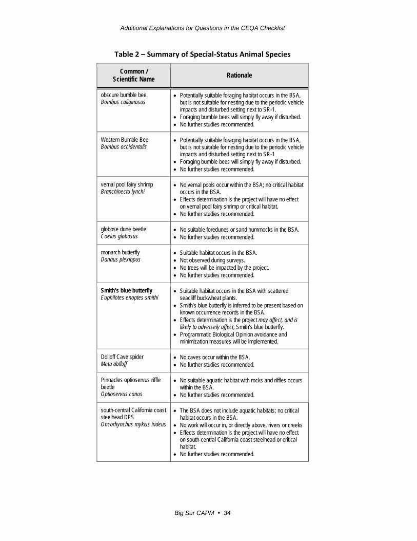
A summary of special-status animal species considered is presented in Table 2.
Due to their threatened and/or endangered status, Smith’s blue butterfly and California red-legged frog are discussed in the Threatened and Endangered Species section.
Additional Explanations for Questions in the CEQA Checklist
Big Sur CAPM 34
Table 2 – Summary of Special-Status Animal Species
Common / Scientific Name Rationale
obscure bumble bee Bombus caliginosus
• Potentially suitable foraging habitat occurs in the BSA, but is not suitable for nesting due to the periodic vehicle impacts and disturbed setting next to SR-1.
• Foraging bumble bees will simply fly away if disturbed. • No further studies recommended.
Western Bumble Bee Bombus occidentalis
• Potentially suitable foraging habitat occurs in the BSA, but is not suitable for nesting due to the periodic vehicle impacts and disturbed setting next to SR-1
• Foraging bumble bees will simply fly away if disturbed. • No further studies recommended.
vernal pool fairy shrimp Branchinecta lynchi
• No vernal pools occur within the BSA; no critical habitat occurs in the BSA.
• Effects determination is the project will have no effect on vernal pool fairy shrimp or critical habitat.
• No further studies recommended.
globose dune beetle Coelus globosus
• No suitable foredunes or sand hummocks in the BSA. • No further studies recommended.
monarch butterfly Danaus plexippus
• Suitable habitat occurs in the BSA. • Not observed during surveys. • No trees will be impacted by the project. • No further studies recommended.
Smith’s blue butterfly Euphilotes enoptes smithi
• Suitable habitat occurs in the BSA with scattered seacliff buckwheat plants.
• Smith’s blue butterfly is inferred to be present based on known occurrence records in the BSA.
• Effects determination is the project may affect, and is likely to adversely affect, Smith’s blue butterfly.
• Programmatic Biological Opinion avoidance and minimization measures will be implemented.
Dolloff Cave spider Meta dolloff
• No caves occur within the BSA. • No further studies recommended.
Pinnacles optioservus riffle beetle Optioservus canus
• No suitable aquatic habitat with rocks and riffles occurs within the BSA.
• No further studies recommended.
south-central California coast steelhead DPS Oncorhynchus mykiss irideus
• The BSA does not include aquatic habitats; no critical habitat occurs in the BSA.
• No work will occur in, or directly above, rivers or creeks • Effects determination is the project will have no effect
on south-central California coast steelhead or critical habitat.
• No further studies recommended.
Additional Explanations for Questions in the CEQA Checklist
Big Sur CAPM 35
Common / Scientific Name Rationale
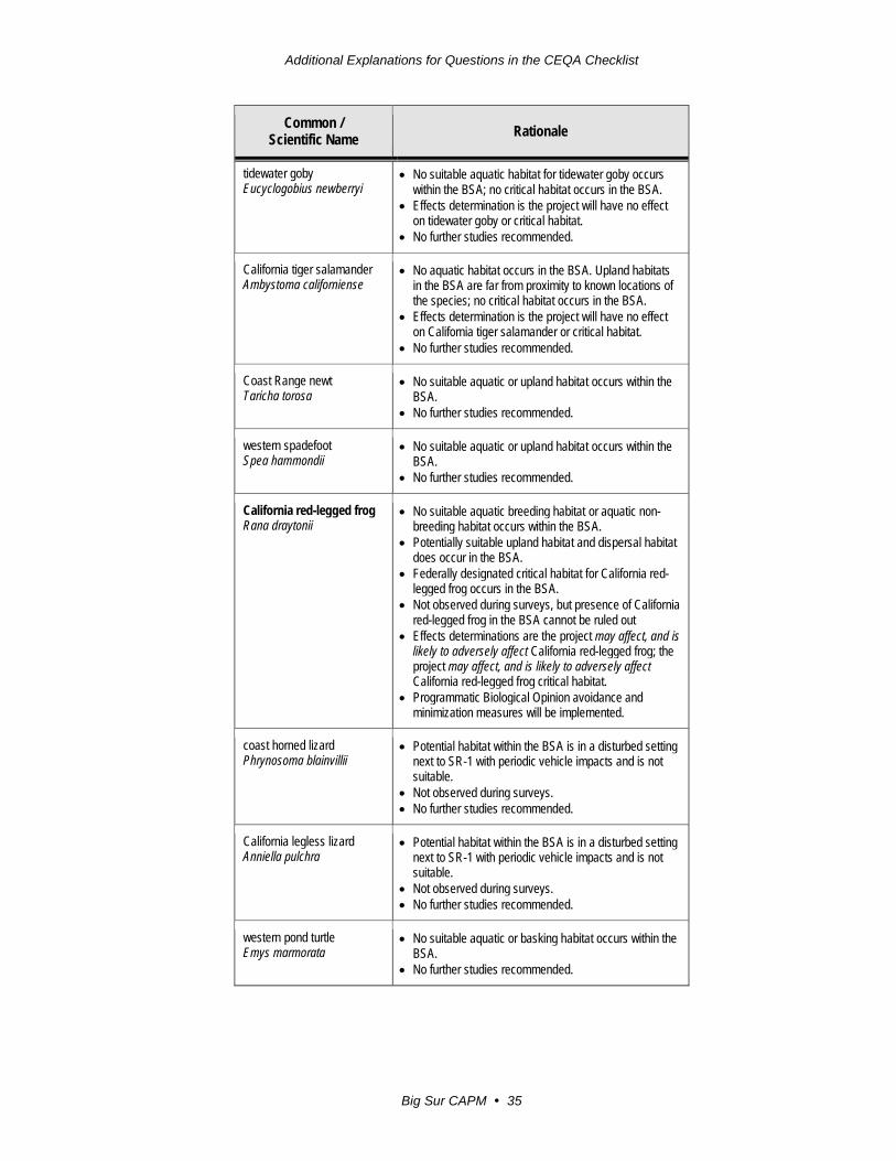
tidewater goby Eucyclogobius newberryi
• No suitable aquatic habitat for tidewater goby occurs within the BSA; no critical habitat occurs in the BSA.
• Effects determination is the project will have no effect on tidewater goby or critical habitat.
• No further studies recommended.
California tiger salamander Ambystoma californiense
• No aquatic habitat occurs in the BSA. Upland habitats in the BSA are far from proximity to known locations of the species; no critical habitat occurs in the BSA.
• Effects determination is the project will have no effect on California tiger salamander or critical habitat.
• No further studies recommended.
Coast Range newt Taricha torosa
• No suitable aquatic or upland habitat occurs within the BSA.
• No further studies recommended.
western spadefoot Spea hammondii
• No suitable aquatic or upland habitat occurs within the BSA.
• No further studies recommended.
California red-legged frog Rana draytonii
• No suitable aquatic breeding habitat or aquatic non-breeding habitat occurs within the BSA.
• Potentially suitable upland habitat and dispersal habitat does occur in the BSA.
• Federally designated critical habitat for California red-legged frog occurs in the BSA.
• Not observed during surveys, but presence of California red-legged frog in the BSA cannot be ruled out
• Effects determinations are the project may affect, and is likely to adversely affect California red-legged frog; the project may affect, and is likely to adversely affect California red-legged frog critical habitat.
• Programmatic Biological Opinion avoidance and minimization measures will be implemented.
coast horned lizard Phrynosoma blainvillii
• Potential habitat within the BSA is in a disturbed setting next to SR-1 with periodic vehicle impacts and is not suitable.
• Not observed during surveys. • No further studies recommended.
California legless lizard Anniella pulchra
• Potential habitat within the BSA is in a disturbed setting next to SR-1 with periodic vehicle impacts and is not suitable.
• Not observed during surveys. • No further studies recommended.
western pond turtle Emys marmorata
• No suitable aquatic or basking habitat occurs within the BSA.
• No further studies recommended.
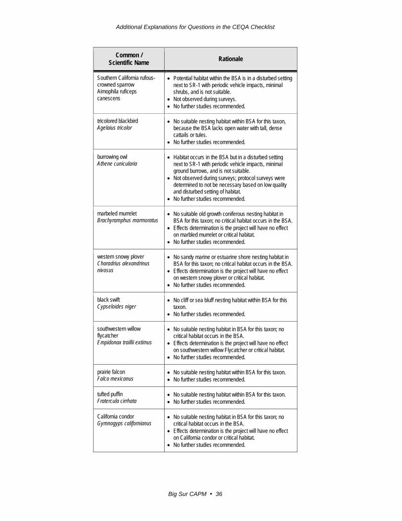
Additional Explanations for Questions in the CEQA Checklist
Big Sur CAPM 36
Common / Scientific Name Rationale
Southern California rufous-crowned sparrow Aimophila ruficeps canescens
• Potential habitat within the BSA is in a disturbed setting next to SR-1 with periodic vehicle impacts, minimal shrubs, and is not suitable.
• Not observed during surveys. • No further studies recommended.
tricolored blackbird Agelaius tricolor
• No suitable nesting habitat within BSA for this taxon, because the BSA lacks open water with tall, dense cattails or tules.
• No further studies recommended.
burrowing owl Athene cunicularia
• Habitat occurs in the BSA but in a disturbed setting next to SR-1 with periodic vehicle impacts, minimal ground burrows, and is not suitable.
• Not observed during surveys; protocol surveys were determined to not be necessary based on low quality and disturbed setting of habitat.
• No further studies recommended.
marbeled murrelet Brachyramphus marmoratus
• No suitable old growth coniferous nesting habitat in BSA for this taxon; no critical habitat occurs in the BSA.
• Effects determination is the project will have no effect on marbled murrelet or critical habitat.
• No further studies recommended.
western snowy plover Charadrius alexandrinus nivosus
• No sandy marine or estuarine shore nesting habitat in BSA for this taxon; no critical habitat occurs in the BSA.
• Effects determination is the project will have no effect on western snowy plover or critical habitat.
• No further studies recommended.
black swift Cypseloides niger
• No cliff or sea bluff nesting habitat within BSA for this taxon.
• No further studies recommended.
southwestern willow flycatcher Empidonax traillii extimus
• No suitable nesting habitat in BSA for this taxon; no critical habitat occurs in the BSA.
• Effects determination is the project will have no effect on southwestern willow Flycatcher or critical habitat.
• No further studies recommended.
prairie falcon Falco mexicanus
• No suitable nesting habitat within BSA for this taxon. • No further studies recommended.
tufted puffin Fratercula cirrhata
• No suitable nesting habitat within BSA for this taxon. • No further studies recommended.
California condor Gymnogyps californianus
• No suitable nesting habitat in BSA for this taxon; no critical habitat occurs in the BSA.
• Effects determination is the project will have no effect on California condor or critical habitat.
• No further studies recommended.
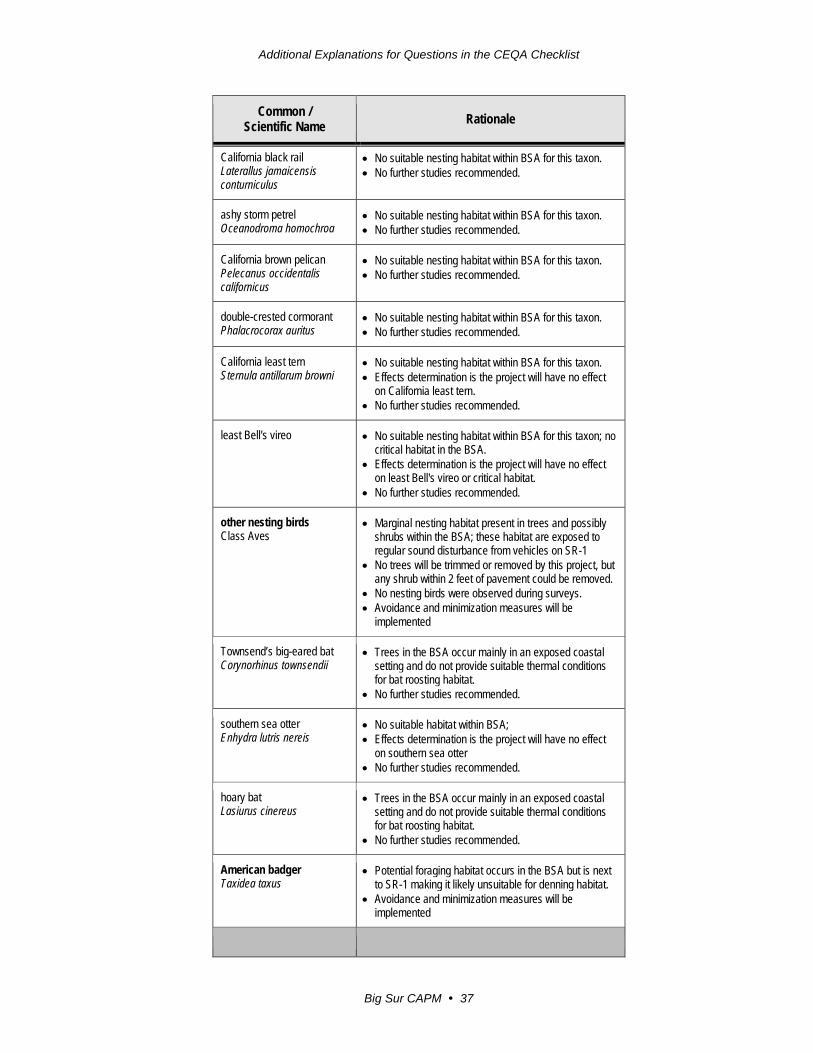
Additional Explanations for Questions in the CEQA Checklist
Big Sur CAPM 37
Common / Scientific Name Rationale
California black rail Laterallus jamaicensis conturniculus
• No suitable nesting habitat within BSA for this taxon. • No further studies recommended.
ashy storm petrel Oceanodroma homochroa
• No suitable nesting habitat within BSA for this taxon. • No further studies recommended.
California brown pelican Pelecanus occidentalis californicus
• No suitable nesting habitat within BSA for this taxon. • No further studies recommended.
double-crested cormorant Phalacrocorax auritus
• No suitable nesting habitat within BSA for this taxon. • No further studies recommended.
California least tern Sternula antillarum browni
• No suitable nesting habitat within BSA for this taxon. • Effects determination is the project will have no effect
on California least tern. • No further studies recommended.
least Bell's vireo • No suitable nesting habitat within BSA for this taxon; no critical habitat in the BSA.
• Effects determination is the project will have no effect on least Bell's vireo or critical habitat.
• No further studies recommended.
other nesting birds Class Aves
• Marginal nesting habitat present in trees and possibly shrubs within the BSA; these habitat are exposed to regular sound disturbance from vehicles on SR-1
• No trees will be trimmed or removed by this project, but any shrub within 2 feet of pavement could be removed.
• No nesting birds were observed during surveys. • Avoidance and minimization measures will be
implemented
Townsend’s big-eared bat Corynorhinus townsendii
• Trees in the BSA occur mainly in an exposed coastal setting and do not provide suitable thermal conditions for bat roosting habitat.
• No further studies recommended.
southern sea otter Enhydra lutris nereis
• No suitable habitat within BSA; • Effects determination is the project will have no effect
on southern sea otter • No further studies recommended.
hoary bat Lasiurus cinereus
• Trees in the BSA occur mainly in an exposed coastal setting and do not provide suitable thermal conditions for bat roosting habitat.
• No further studies recommended.
American badger Taxidea taxus
• Potential foraging habitat occurs in the BSA but is next to SR-1 making it likely unsuitable for denning habitat.
• Avoidance and minimization measures will be implemented

Additional Explanations for Questions in the CEQA Checklist
Big Sur CAPM 38
American Badger The American badger (Taxidea taxus) occurs in open shrub lands, forest, and herbaceous habitats. The American badger burrows for cover, estivation, and nesting. It needs uncultivated ground with friable soils to excavate its burrows.
Although no American badger or evidence of presence was observed in the project areas during multiple survey visits to the BSA, an occurrence of this species has been recorded approximately 0.3 miles east of the BSA near postmile 57.6. The American badger is adapted to digging and life underground, and portions of the BSA have crumbly soils or are close to areas with crumbly soils that are easy for digging. The BSA provides potentially suitable foraging habitat for American badger and there is the potential for American badger to enter the BSA due to the transitory nature of the species. Based on the traffic along SR-1, it is unlikely that the BSA would provide suitable denning habitat for the American badger.
Migratory Birds Within the BSA there are suitable foraging and nesting habitats for some bird species. Trees, shrubs and even bare ground within the BSA could provide potential nesting habitat for birds. The species listed in Table 2 are protected by the Migratory Bird Treaty Act (MBTA) and the California Fish and Game Code (FGC) Section 3503.
No migratory birds were observed in the project area during multiple survey visits of the BSA. It is unlikely that nesting birds would be found within close proximity of SR-1, but birds may be found foraging within the BSA.
Environmental Consequences
American Badger While it is not anticipated that the project will have a direct impact on the American badger, construction work has a small potential to kill, trap, or injure this species. Implementation of the avoidance and minimization measures below will reduce the potential for impacts.
Migratory Birds Nesting birds within the BSA may be disturbed by construction activities resulting from the project. No tree removal will occur, but some limited shrub removal may be required.
Should migratory birds nest in trees within the project BSA, they would likely not be more disturbed by the construction activities of this project than by the ambient traffic and human activity that occurs around the highway, residences, and business.
Additional Explanations for Questions in the CEQA Checklist
Big Sur CAPM 39
While it is unlikely that birds would nest in close proximity of the highway, it cannot be completely discounted. Any shrubs found on the edge of the highway or vegetated or un-vegetated portions of the API or vehicle pullouts may be used by nesting birds. Any shrubs within two feet from the edge of pavement could be removed for shoulder backing and pullouts could be used for vehicle staging and equipment storage.
Avoidance, Minimization and/or Mitigation
The following avoidance and minimization measures will be implemented for animal species:
American Badger 1. Prior to, during, and after the site-disturbance and/or construction phase, use
of pesticides or herbicides should be in compliance with all federal, state, and local regulations. No rodent control pesticides shall be used, including anticoagulant rodenticides such as brodifacoum, bromadiolone, difethialone and difenacoum. This is necessary to minimize the possibility of primary or secondary poisoning of American badger or other special status species.
2. A litter control program shall be instituted at each project site. No canine or feline pets or firearms (except for law enforcement officers and security personnel) shall be permitted on construction sites in order to avoid harassment, killing, or injuring of badger.
Migratory Birds 1. If feasible, vegetation removal in the API should be scheduled to occur
between September 30 and February 1, which is outside of the typical nesting season. If vegetation removal, or other work is proposed within potential nesting habitat during the nesting season (February 1 to September 30), preconstruction nesting bird surveys shall be conducted by a qualified biologist within 14 days prior to the onset of work activities for active nests of birds that are protected under the MBTA. 100-foot exclusion zones around active nests shall be established by a qualified biologist or designee until Caltrans coordinates with CDFW to determine an appropriate buffer based on the habits and needs of the species. The buffer area shall be avoided until a qualified biologist has determined that juveniles have fledged.
2. Active bird nests shall not be disturbed and eggs or young of birds covered by the MBTA and California FGC shall not be killed, destroyed, injured, or harassed at any time. Readily visible exclusion zones where nests must be avoided shall be established prior to construction activities by a qualified biologist using Environmentally Sensitive Area (ESA) fencing or high visibility flagging.
Additional Explanations for Questions in the CEQA Checklist
Big Sur CAPM 40
Threatened and Endangered Species
Affected Environment
This section is based on information that was included in the NES-MI (October 2017) prepared for this project.
Plant surveys were conducted during the appropriate time and found that no federally-listed plant species or designated critical habitat for federally listed plant species occurs within the BSA.
Two federally listed animal species have the potential to occur within the project API: Smith’s blue butterfly and California red-legged frog.
The project qualify for inclusion under existing Programmatic Biological Opinions (PBOs) for both the Smith’s blue butterfly and the California red-legged frog for the purpose of Federal Endangered Species Act (FESA) consultation with the U.S. Fish and Wildlife Service (USFWS).
Smith’s Blue Butterfly The Smith’s blue butterfly (Euphilotes enoptes smithi) is a federally endangered insect. The historic range of Smith’s blue butterfly (SBB) includes dune habitat along Monterey Bay, from the Salinas River south to the City of Monterey, and from the Carmel River south to San Carpoforo Creek in northern San Luis Obispo County. The decline of SBB across its range is a result of degradation and loss of habitat from urban development, recreational activities, sand mining, military activities, fire suppression, and encroachment of invasive plants.
The SBB’s primary host plant is seacliff buckwheat during all life stages, but the species may also utilize coast buckwheat as a host plant, and adults are known to feed on the nectar of naked buckwheat.
All life stages are dependent on the host plant. Adults feed on the nectar, and females deposit eggs on the flowers. The larvae feed on the flowers and seeds, and then pupate on or beneath the plants. The SBB life-cycle is one generation per year.
Adults are generally active at a particular location for about four to ten weeks, but the adult activity period and duration can vary dramatically from year to year and from one location to another.
The presence of SBB is inferred within the project limits based on the following information:
1) Suitable habitat for SBB occurs within several portions of the project BSA as both species of buckwheat host plants were identified during botanical surveys.

Additional Explanations for Questions in the CEQA Checklist
Big Sur CAPM 41
2) The species is included on both the California Natural Diversity Database (CNDDB) and USFWS species lists.
3) The species is known to inhabit the project area, as documented in USFWS publications.
4) Several CNDDB occurrence records of the species are located within the project limits.
5) Caltrans has detected the species in protocol-level surveys conducted for several other projects in the region over the last 15 years.
Protocol-level surveys for SBB were not conducted for this project, due to the length of the project; instead, individual buckwheat host plants were identified and located within the project API, as required under the SBB PBO. Buckwheat surveys conducted in 2017 identified 75 individual seacliff buckwheat plants growing within the project API and their locations were recorded using a Global Positioning System (GPS) unit.
California Red-Legged Frog The California red-legged frog (Rana draytonii) is a federally threatened species and a California Species of Special Concern. California red-legged frog (CRLF) historically range from Marin County southward to northern Baja California. Presently, Monterey, San Luis Obispo, and Santa Barbara counties support the largest remaining CRLF populations within California.
The CRLF uses a variety of habitats, including aquatic, riparian, and upland habitats. Both riparian and upland habitats are used by CRLF for foraging, shelter and cover. They prefer aquatic habitats with little or no flow, water depth of at least 2.3 feet, and the presence of fairly sturdy underwater supports such as cattails and reeds. Upland refuges may be of natural or manmade origins. The CRLF will also use small mammal burrows and moist leaf litter as refugia. The dispersal of distance of CRLF is known to be approximately one mile.
The project BSA contains no suitable aquatic breeding habitat or suitable aquatic and riparian non-breeding habitat. As a result, surveys were conducted to identify suitable upland habitat within proximity of known CRLF occurrences, breeding ponds or suitable aquatic habitat.
There are eight CNDDB records of CRLF within one mile of the project limits. All these records were of CRLF found in aquatic habitats. Section of the BSA within a one-mile proximity of these aquatic sites were visually assessed for CRLF upland habitat. Some were found to contain potentially suitable upland habitat such as grasslands with mammal burrows or structural materials such as logs, rocks and leaf litter. Portions of the BSA may also be suitable dispersal habitat for CRLF moving from aquatic habitat to upland habitat.

Additional Explanations for Questions in the CEQA Checklist
Big Sur CAPM 42
During general wildlife surveys, CRLF were not observed within the BSA and due to the lack of aquatic habitat in the BSA, no protocol surveys were conducted. While the proximity to SR-1 may prevent or preclude CRLF from taking refuge within the BSA, or causing mortalities to CRLF attempting to cross the highway, the presence of CRLF in the BSA cannot be ruled out considering the specie’s ability to utilize a wide variety of habitats for dispersals, foraging and shelter. Therefore, CRLF is inferred to utilize portions of the BSA as dispersal habitat and possibly upland habitat as well.
Environmental Consequences
Smith’s Blue Butterfly In an effort to avoid and minimize impacts to SBB as a result of the project, any seacliff buckwheat identified within the API will be relocated. A USFWS-authorized biologist will relocate seacliff buckwheat plants, their associated duff, and soil to an area as close as possible to suitable adjacent habitat prior to the onset of project activities. The GPS data with the 2017 buckwheat plant locations will be used, along with any other additional buckwheat locations found in the preconstruction survey.
Moving entire plants and placing them adjacent to live seacliff buckwheat, while also collecting and moving all duff from translocated plants, should minimize mortality of pupae and emerging adults. While this is the best known method to avoid and minimize impacts to SBB, some of the relocated plants may not survive and individual SBB or pupae could be killed during the relocation process.
Although focused and comprehensive buckwheat surveys were conducted in 2016 and again in 2017, it is possible that not every single SBB host was identified in the 34.8 mile long survey. While an additional buckwheat survey will be conducted no more than 30 days prior to ground disturbance, any host plants that are not identified in the API could be accidentally destroyed. If those plants are occupied by SBB, they could be crushed, buried, or otherwise killed. It is also possible that adult SBB may simply fly away from host plants, should occupied plants be destroyed, but any pupae occupying those plants are likely to be killed. The SBB may also be adversely affected through a loss of foraging habitat and in increase in habitat fragmentation due to relocation or removal of host buckwheat plants.
It is anticipated that relocation of seacliff buckwheat plants from the API will reduce impacts to SBB as a result of the project. The number of host plants affected by relocation or accidental destruction is extremely low, considering the relative quantity of seacliff buckwheat found along the Big Sur Coast. It should also be noted that these potentially affected plants occur in an area within two feet from the highway pavement, where it is regularly disturbed by human activities.

Additional Explanations for Questions in the CEQA Checklist
Big Sur CAPM 43
The FESA Section 7 determination is that the project may affect, and is likely to adversely affect SBB, but would not affect the long-term viability of the population in the region. The project will remove a narrow strip of SBB habitat along the highway and is unlikely to have a substantial impact to SBB population.
No federal critical habitat has been designated for SBB.
California Red Legged Frog The project will involve no work that will take place in or directly adjacent to aquatic or riparian areas. Vegetation removal and minor grading will occur within the 2-foot API directly adjacent to the edge of pavement and shoulder backing will be installed. This work has the possibility to kill, injure, or bury CRLF, if they are present within the API at the time of construction. Potentially suitable CRLF upland habitat within the API has been determined to be of low quality due to the proximity of SR-1.
Based on the conclusions above, the project may affect CRLF, because “take” is possible as defined under the FESA. The potential effect to CRLF would not be insignificant, since the effect would be “take”. The chance for a CRLF being in the API at the time of construction is unlikely, but not discountable due to the continuous length of the API along SR-1.
The FESA Section 7 determination is that the project may affect, and is likely to adversely affect CRLF, but would not affect the long-term viability of the population in the region. The project will impact low-quality habitat along the edges of the highway and is unlikely to have a substantial impact to CRLF population.
Portions of the API are located within federally designated critical habitat for the CRLF. The project transects 1.3 miles of CRLF critical habitat unit MNT-2 and 19.8 miles of CRLF critical habitat unit MNT-3. While the quality of critical habitat in the API is low due to periodic impacts from vehicles, maintenance and human activities, CRLF could utilize this critical habitat, which will be permanently impacted from the installation of shoulder backing.
Of the 119,492 acres of critical habitat within California red-legged frog critical habitat unit MNT-2, the impacts associated with the project equate to less than 0.6303 acre or less than 0.0005% of the total critical habitat unit.
Of the 27,542 acres of critical habitat within California red-legged frog critical habitat unit MNT-3, the impacts associated with the project equate to less than 7.2727 acres or 0.0264% of the total critical habitat unit.
It should be noted that these calculations are over-estimations as they do not take into account sections of the road where shoulder backing will not be installed, such as locations where hillsides or steep slopes are directly adjacent to the road.

Additional Explanations for Questions in the CEQA Checklist
Big Sur CAPM 44
The FESA Section 7 determination is that the project may affect, and is likely to adversely affect CRLF critical habitat. The basis of this determination is that the presence of CRLF has been inferred based on the known dispersal range of CRLF and the presence of suitable upland habitat along portions of the BSA.
Avoidance, Minimization and/or Mitigation
Smith’s Blue Butterfly With implementation of the following avoidance and minimization measures from the 2008 SBB PBO, the potential for impacts to SBB will be reduced:
1. Caltrans will ensure that all construction activities follow well-defined procedures to avoid effects to the Smith’s blue butterfly.
2. Caltrans will prohibit mowing and broadcast spraying of herbicide in stands of buckwheat. Within areas that contain buckwheat, control of invasive weeds, which is beneficial to buckwheat, will be achieved by spot spraying of herbicide and/or hand clearing.
3. Caltrans will ensure that only USFWS-approved biologists will participate in capture, handling, and monitoring of the SBB, in all of its life stages, and the handling of buckwheat plants.
4. Caltrans will ensure that ground disturbance for maintenance or project activities will not begin within stands of buckwheat until a USFWS-approved biologist is on site.
5. USFWS-approved biologists will verify that the proposed work activity within stands of buckwheat meets all criteria established for use of this biological opinion.
6. For maintenance work or project activity within stands of buckwheat, a USFWS-approved biologist will survey the work site no more than 30 days before the onset of ground disturbance. If any life stage of the SBB or its host plant, seacliff buckwheat, is found and is likely to be killed or injured by work activities, the approved biologist will be allowed sufficient time to relocate seacliff buckwheat plants, duff, and/or soil from the site before work activities begin. The seacliff buckwheat plants, duff, and/or soil will be hand removed and placed as close as possible to, but not on, living seacliff buckwheat plants. The USFWS-approved biologist will relocate the seacliff buckwheat plants, duff, and/or soil to the shortest distance possible to a location that contains suitable habitat and will not be affected by activities associated with the project. The USFWS-approved biologist will maintain detailed records of the number of seacliff buckwheat plants that are moved.
Additional Explanations for Questions in the CEQA Checklist
Big Sur CAPM 45
7. Before any maintenance or project activity work begins within stands of buckwheat, a USFWS-approved biologist will provide training to all field personnel. At a minimum, the training will include a description of the Smith’s blue butterfly and its habitat, the specific measures that are being implemented to conserve the SBB, and boundaries within which the project may be accomplished. Brochures, books, and briefings may be used in the training session, provided that a qualified person is on hand to answer any questions.
8. A USFWS-approved biologist will be present at the work site for maintenance or project activity within stands of buckwheat until all Smith’s blue butterflies and seacliff buckwheat plants that are at risk due to project activities have been removed, workers have been instructed, and disturbance to habitat has been completed. After this time, Caltrans will designate a person to monitor on-site compliance with all minimization measures. The USFWS-approved biologist will ensure that this monitor receives the training outlined in measure 7 and in the identification of the SBB and its host plant, seacliff buckwheat. If the monitor or the USFWS-approved biologist recommend that work be stopped because the SBB or seacliff buckwheat would be affected to a degree that exceeds the levels anticipated by Caltrans and USFWS during review of the proposed action, they will notify the resident engineer (the engineer that is directly overseeing and in command of construction activities) immediately. The resident engineer will either resolve the situation by eliminating the unanticipated effect(s) immediately, or require that all actions causing these effects be halted. If work is stopped, the USFWS will be notified as soon as is reasonably possible.
9. An assemblage of native species will be used for revegetation of project sites. Seacliff buckwheat seed or plants will only be placed outside the vegetation control areas. The spread of invasive weeds during revegetation efforts will be controlled according to the Vegetation Management Guidelines (Caltrans 2002) developed as part of the Big Sur Coast Highway Management Plan (Caltrans 2004).
10. The number of access routes, size of staging areas, and the total area of the activity will be limited to the minimum necessary to achieve the project goal. Environmentally Sensitive Areas will be established to confine access routes and construction areas to the minimum area necessary to complete construction, and minimize impact to Smith’s blue butterfly and seacliff buckwheat.
11. Caltrans will ensure that best management practices are implemented according to the most current approved guidelines to control erosion and sedimentation during and after project implementation. Weed-free hay and straw bales would be used for erosion control measures when they become available.

Additional Explanations for Questions in the CEQA Checklist
Big Sur CAPM 46
In accordance with the provisions of the incidental take statement contained within the 2008 SBB PBO, Caltrans must comply with, or ensure that, any contractors comply with the following terms and conditions, which implement the reasonable and prudent measures described in the 2008 SBB PBO and the reporting and monitoring requirements. These terms and conditions are non-discretionary.
12. Only qualified individuals authorized under the 2008 SBB PBO may survey for seacliff buckwheat, remove seacliff buckwheat plants, and collect and place duff. Caltrans must supply the credentials of any additional proposed qualified individuals to the Service for their review and approval at least 15 days prior to the onset of the activities for which authorization is being sought.
13. If more than three (3) SBBs are found dead or injured, Caltrans must notify the Ventura Fish and Wildlife Office immediately. The USFWS will then review the project activities to determine if additional protective measures are needed. Project activities may continue during this review period, provided that all protective measures proposed by Caltrans and the terms and conditions of this biological opinion have been, and continue to be, implemented.
14. Upon locating a dead SBB, the Caltrans project biologist shall be contacted within 24 hours, who will in turn contact the USFWS Division of Law Enforcement. Information of the mortality must include the date, time, location of the specimen, cause of death, if known and any other pertinent information. Care must be taken in handling dead specimens to preserve biological material in the best possible state.
California Red-Legged Frog Measures will be implemented in all areas disturbed by activities associated with the project, unless Caltrans with written agreement from the USFWS determine that a certain measure is not feasible or practical.
The following measures from the USFWS CRLF PBO will be implemented to reduce potential effects to the CRLF and its critical habitat:
1. Only USFWS-approved biologists will participate in activities associated with the capture, handling, and monitoring of California red-legged frogs. Biologists authorized under the PBO do not need to re-submit their qualifications for this project unless the USFWS has revoked their approval at any time during the life of the PBO.
2. Ground disturbance will not begin until written approval is received from the USFWS that the biologist is qualified to conduct the work, unless the individual(s) has/have been approved previously and the USFWS has not revoked that approval.
3. A USFWS-approved biologist will survey the project site no more than 48 hours before the onset of work activities. If any life stage of the CRLF is
Additional Explanations for Questions in the CEQA Checklist
Big Sur CAPM 47
found and these individuals are likely to be killed or injured by work activities, the approved biologist will be allowed sufficient time to move them from the site before work begins. The USFWS-approved biologist will relocate the CRLF the shortest distance possible to a location that contains suitable habitat and that will not be affected by activities associated with the project. The relocation site should be in the same drainage to the extent practicable. Caltrans will coordinate with the Service on the relocation site prior to the capture of any CRLF.
4. Before work begins on the project, a USFWS-approved Caltrans biologist with experience in the ecology of the CRLF, as well as the identification of all its life stages, will conduct a training session for all construction personnel, which will include a description of the CRLF, its critical habitat, and specific measures that are being implemented to avoid adverse effects to the subspecies during the project. Brochures, books, and briefings may be used in the training session, provided that a qualified person is on hand to answer any questions.
5. Prior to or during project activities, if any observations are made of CRLF within the project limits, the contractor will contact the Caltrans Project Biologist. All work within 500 feet of the CRLF will stop until such time that Caltrans determines from USFWS if it is appropriate to resume work. If any life stage of the CRLF is found and these individuals are likely to be killed or injured by work activities, a USFWS-approved biologist shall be allowed sufficient time to move them from the site before work begins. The USFWS-approved biologist shall relocate the CRLF the shortest distance possible to a location that contains suitable habitat and will not be affected by the activities associated with the project. The relocation site shall be in the same drainage to the extent practicable. Caltrans shall coordinate with USFWS on the relocation site prior to the capture of any CRLF.
6. During project activities, all trash that may attract predators or scavengers shall be properly contained, removed from the work site, and disposed of regularly. Following construction, all trash and construction debris shall be removed from work areas.
7. To control fuel and chemical spills, as well as sedimentation during and after project completion, Caltrans shall implement Best Management Practices (BMPs) outlined in the 2015 Caltrans Standard Specifications and Plans. All refueling, maintenance, and staging of equipment and vehicles will occur at least 60 feet from riparian habitat or water bodies and in a location from where a spill would not drain directly toward aquatic habitat
8. Habitat contours will be returned to their original configuration at the end of project activities in all areas that have been temporarily disturbed by activities associated with the project, unless Caltrans and the Service determine that it is not feasible or modification of original contours would benefit the CRLF.

Additional Explanations for Questions in the CEQA Checklist
Big Sur CAPM 48
9. The size of staging areas, and the total area of the activity will be limited to the minimum necessary to achieve the project goals. All aquatic habitat in the Caltrans ROW and within the project limits, such as ponds, seasonally wet areas, drainages, standing water, and riparian areas will be delineated with ESA fencing and confined from construction activities.
10. Work activities will be scheduled between May 1 and October 31 to minimize potential effects upon CRLF during their upland dispersal season. Should activities need to be conducted outside of this period, work may be conducted when no rain is forecasted 24 hours prior to work activities and no rain is forecasted during work activities, unless the USFWS has provided prior written approval.
11. Upon completion of this project for which the PBO is used, Caltrans will ensure that a Project Completion Report is completed and provided to the USFWS Ventura Office. Caltrans should include recommended modifications of the protective measures if alternative measures would facilitate compliance with the provisions of this consultation. In addition, Caltrans will reinitiate formal consultation in the event any of the PBO thresholds are reached as a result of projects conducted under the provisions of the PBO.
V. Cultural Resources
Affected Environment
The project is within Big Sur, a dramatic region along California’s central coast where the Santa Lucia coast range descends steeply into the Pacific Ocean. The southern study area is mostly surrounded by the Los Padres National Forest, much of which in this area is designated as the Ventana Wilderness. The rugged mountains are incised by steep stream drainages with very few flat areas. Coastal terraces are few, and where they do exist they are generally quite narrow. The northern study area is characterized by marine terraces, low-lying sandy beaches, and river drainages and valleys.
Nearly all of the project falls within the boundaries of the Carmel-San Simeon Highway Historic District, which extends from postmile 71.3 to postmile 74.3 in San Luis Obispo County, and from postmile 0.0 to postmile 72.5 in Monterey County. The Carmel-San Simeon Highway Historic District is a noncontiguous historic district that includes 234 rustic-style rubble stone masonry parapet walls, culvert headwalls, retaining walls, and fountains, as well as seven concrete arch bridges known as the “Big Sur Arches”.
An Area of Direct Impact (ADI) was established for cultural resource studies and is comprised of the entire area where project related activities have potential to directly affect archaeological or historic resources. For this project, paving will be limited to the existing paved roadway, and will not extend beyond previously paved areas.

Additional Explanations for Questions in the CEQA Checklist
Big Sur CAPM 49
Shoulder backing will extend approximately two feet beyond the edge of pavement except in areas adjacent to archeological sites, where shoulder backing will be eliminated. The ADI was therefore established as the paved roadway and the area four feet beyond the edge of pavement in areas where shoulder backing will occur; in areas where shoulder backing will not occur (areas adjacent to archeological sites), the ADI consists of only the paved roadway and does not extend past the edge of pavement. In areas where guardrails will be modified or replaced, the ADI also includes the guardrail and adjacent space two feet beyond the guardrail.
Environmental Consequences
Along the 34.8-mile stretch of highway where the project will occur, there are 110 contributing resources to the Carmel-San Simeon Highway Historic District; 55 of these are adjacent to the ADI (19 masonry parapets, 30 culvert headwalls and 6 concrete arch bridges). In addition, ten archeological sites are adjacent to the ADI.
The project is not anticipated to impact cultural resources as the project’s design will allow for the avoidance of cultural resources.
All cultural resources will be protected from project activities by ESA delineation.
Avoidance, Minimization and/or Mitigation
With the implementation of the following measures, the potential cultural impacts of this project can be reduced and would not result in substantial adverse impacts to the existing cultural resources:
• Cultural resources shall be avoided and protected from inadvertent effects through the establishments of Environmentally Sensitive Areas (ESA).
• For archeological resources, Temporary Fence (type ESA) will be installed just outside the edge of pavement to delineate the extent of where work is allowed at these ESA locations.
• For Historic resources located in very close proximity to paving and shoulder backing activities where it is not feasible to install ESA fencing, temporary visual barriers (caution tape, delineators, cones, etc.) will be placed to indicate ESAs.
• Temporary/movable ESA barriers may be utilized to delineate small ESA areas, and may be moved/reused for multiple ESAs as long as each barrier is placed prior to work occurring at each location, and may not be removed until after construction is completed at each location.
• Caltrans-defined ESAs shall be noted on design plans and delineated in the field prior to the start of construction activities.
• Modified construction techniques will also be utilized in some areas to ensure that cultural resources will not be affected by adjacent construction activities.

Additional Explanations for Questions in the CEQA Checklist
Big Sur CAPM 50
• Shoulder backing will be eliminated in locations adjacent to archaeological resources and construction activities will be restricted to the previously disturbed highway footprint.
• In areas where historic masonry structures are located less than one foot from the edge of pavement, construction will include a six-inch buffer from masonry structures when grinding pavement to allow equipment to operate without damaging masonry structures.
• Areas where historic masonry structures are located within two feet from the edge of pavement, shoulder backing width will be adjusted so that it will not physically impact or make contact with masonry structures. Grinding pavement edges will occur where necessary in order to repave at the same level as existing pavement and eliminate the need for shoulder backing.
• Prior to project construction, the Caltrans Archeologist, Architectural Historian, and Environmental-Construction Liaison will meet with the Resident Engineer, Contractor, and any responsible parties who will be working on the project near any ESA in order to discuss the significance of historical and archeological resources in the project area and to explain why protection and avoidance of these resources is necessary. Additionally, personnel will be informed of historic preservation laws that protect historic properties against any disturbance or removal of artifacts.
• No project-related activities (paving, shoulder backing, maintenance, equipment parking/storage, construction staging etc.) shall take place within the ESAs.

Big Sur CAPM 51
Appendix A Construction Impacts
Construction Impacts
The project proposes to repave the road surface on approximately 35 miles of SR-1. Repaving will involve grinding approximately two inches of the top layer from the existing roadway. The roadway grinding and repaving will occur one lane at a time and in sectional lengths that are manageable for construction. One way traffic control and flagging will be employed along sections or SR-1 undergoing construction. Construction staging and equipment storage would be located within the current alignment and Caltrans right-of-way, and/or in previously disturbed turnout area along the project limits. When construction activities are in proximity of sensitive environmental resources, ESA fencing will be installed to protect resources from potential impacts. Environmentally Sensitive Area will also be delineated in the field and will be approved by the project environmental division prior to the beginning of any construction activities, including equipment storage.
Affected Environment
Traffic and Transportation/Pedestrian and Bicycle Facilities Pedestrian and bicycle access will be maintained during project construction.
Air Quality Certain construction activities can be the source of temporary impacts to air quality. These potential impacts include dust producing activities that occur during grading and paving. Standard provisions included on all Caltrans projects would address air quality impacts generated by construction equipment, grading activities and use of various construction materials.
Noise The project is not considered a Type I or Type II project, as it will not construct a highway on a new location, significantly change the alignment of the existing highway or involve construction of noise abatement on an existing highway. With no changes to the highway capacity or alignment, the project is not subject to Caltrans Traffic Noise Analysis Protocol. While this project will not produce long-term noise impacts, it is important to look at potential short-term noise impacts to nearby homes and businesses caused by construction activities. Various homes and business are located adjacent to SR-1, some of which are less than 75 feet away from the centerline of the highway.

Appendix A Construction Impacts
Big Sur CAPM 52
Environmental Consequences
Traffic and Transportation/Pedestrian and Bicycle Facilities Access for motorist, bicyclist, and pedestrians will be temporarily and intermittently limited during construction activities. Access control shall be provided to allow continued motorist, bicyclist, and pedestrian access along sections of SR-1 undergoing construction.
Air Quality During construction, the project will generate air pollutants. The exhaust from construction equipment contains hydrocarbons, oxides of nitrogen, carbon monoxide, suspended particulate matter, and odors. However, the largest percentage of pollutants would be windblown dust generated during excavation, grading, hauling, and various other activities. The impacts of these activities would vary each day as construction progresses. Dust and odors during construction may cause occasional annoyance and complaints from nearby residences.
Noise Though it is not subject to noise analysis, this project may generate temporary construction related noise impacts. Noise generated by construction activities will be intermittent and its intensity will vary depending on the construction activity.
Avoidance, Minimization, and/or Mitigation Measures
Traffic and Transportation/Pedestrian and Bicycle Facilities No prolonged lane closures are anticipated during construction. Project construction will be conducted in sections, allowing traffic to pass through the project site. Traffic control will be in place during construction.
Air Quality Caltrans Standard Specification section pertaining to dust control and dust palliative application are required for all construction contracts and would effectively reduce and control construction-emission impact. The provisions of Caltrans Standard Specification, Section 10-5 “Dust Control” and Section 14-9 “Air Pollution Control” require the contractor to comply with all California Air Resource Board and San Luis Obispo County Air Pollution Control District rules, ordinances and regulations.
Noise Construction noise is regulated by Caltrans Standard Specification Section 14-8.02 “Noise Control”, which states that noise will not exceed 86 dBA at 50 feet from the job site from 9:00 p.m. to 6:00 a.m. It also states to control and monitor noise resulting from construction activities.

Appendix A Construction Impacts
Big Sur CAPM 53
The following control measures shall also be implemented in order to minimize noise and vibrations disturbances during periods of construction:
Equipment Noise Control
• Use newer equipment with improved muffling and ensure that all equipment items have the manufacturers’ recommended noise abatement measures, such as mufflers, engine enclosures, and engine vibration isolators intact and operational. Newer equipment will generally be quieter in operation that older equipment. All construction equipment should be inspected at periodic intervals to ensure proper maintenance and presence of noise control devices (e.g., mufflers, and shrouding, etc.).
• Use construction methods or equipment that will provide the lowest level of noise and ground vibration impact, such as alternative low noise pile installation methods.
• Turn off idling equipment.
• Temporary noise barriers shall be used and relocated, as needed, to protect sensitive receptors against excessive noise from construction activities. Noise barriers can be made of heavy plywood or moveable insulated sound blankets.
Administrative Measures
• Implement a construction noise and vibration-monitoring program to limit the impacts.
• Plan noisier operations during times of least sensitivity to receptors.
• Keep noise levels relatively uniform and avoid impulsive noises.
• Maintain good public relations with the community to minimize objections to the unavoidable construction impacts. Provide frequent activity update of al construction activities.
• A combination of abatement techniques with equipment noise control and administrative measures can be selected to provide the most effective means to minimize effects of construction activity impacts. Application of abatement measures will reduce the construction impacts: however, a temporary increase in noise and vibration would likely occur.

Appendix A Construction Impacts
Big Sur CAPM 54
This page left intentionally blank

Big Sur CAPM 55
Appendix B Climate Change
Climate change refers to long-term changes in temperature, precipitation, wind patterns, and other elements of the earth's climate system. An ever-increasing body of scientific research attributes these climatological changes to greenhouse gas (GHG) emissions, particularly those generated from the production and use of fossil fuels.
While climate change has been a concern for several decades, the establishment of the Intergovernmental Panel on Climate Change (IPCC) by the United Nations and World Meteorological Organization in 1988 has led to increased efforts devoted to GHG emissions reduction and climate change research and policy. These efforts are primarily concerned with the emissions of GHGs generated by human activity including carbon dioxide (CO2), methane (CH4), nitrous oxide (N2O), tetrafluoromethane, hexafluoroethane, sulfur hexafluoride (SF6), HFC-23 (fluoroform), HFC-134a (s, s, s, 2-tetrafluoroethane), and HFC-152a (difluoroethane).
In the U.S., the main source of GHG emissions is electricity generation, followed by transportation.1 In California, however, transportation sources (including passenger cars, light-duty trucks, other trucks, buses, and motorcycles) are the largest contributors of GHG emissions.2 The dominant GHG emitted is CO2, mostly from fossil fuel combustion.
Two terms are typically used when discussing how we address the impacts of climate change: “greenhouse gas mitigation” and “adaptation.” "Greenhouse gas mitigation" is a term for reducing GHG emissions to reduce or "mitigate" the impacts of climate change. “Adaptation" refers to planning for and responding to impacts resulting from climate change (such as adjusting transportation design standards to withstand more intense storms and higher sea levels).
Regulatory Setting This section outlines federal and state efforts to comprehensively reduce GHG emissions from transportation sources.
Federal To date, no national standards have been established for nationwide mobile-source GHG reduction targets, nor have any regulations or legislation been enacted specifically to address climate change and GHG emissions reduction at the project level.
1 https://www.epa.gov/ghgemissions/us-greenhouse-gas-inventory-report-1990-2014 2 https://www.arb.ca.gov/cc/inventory/data/data.htm

Appendix B Climate Change
Big Sur CAPM 56
The National Environmental Policy Act (NEPA) (42 United States Code [USC] Part 4332) requires federal agencies to assess the environmental effects of their proposed actions prior to making a decision on the action or project.
The Federal Highway Administration (FHWA) recognizes the threats that extreme weather, sea-level change, and other changes in environmental conditions pose to valuable transportation infrastructure and those who depend on it. FHWA therefore supports a sustainability approach that assesses vulnerability to climate risks and incorporates resilience into planning, asset management, project development and design, and operations and maintenance practices.3
This approach encourages planning for sustainable highways by addressing climate risks while balancing environmental, economic, and social values—“the triple bottom line of sustainability.”4 Program and project elements that foster sustainability and resilience also support economic vitality and global efficiency, increase safety and mobility, enhance the environment, promote energy conservation, and improve the quality of life. Addressing these factors up front in the planning process will assist in decision-making and improve efficiency at the program level, and will inform the analysis and stewardship needs of project-level decision-making.
Various efforts have been promulgated at the federal level to improve fuel economy and energy efficiency to address climate change and its associated effects.
The Energy Policy Act of 1992 (EPACT92, 102nd Congress H.R.776.ENR): With this act, Congress set goals, created mandates, and amended utility laws to increase clean energy use and improve overall energy efficiency in the United States. EPACT92 consists of 27 titles detailing various measures designed to lessen the nation's dependence on imported energy, provide incentives for clean and renewable energy, and promote energy conservation in buildings. Title III of EPACT92 addresses alternative fuels. It gave the U.S. Department of Energy administrative power to regulate the minimum number of light-duty alternative fuel vehicles required in certain federal fleets beginning in fiscal year 1993. The primary goal of the Program is to cut petroleum use in the United States by 2.5 billion gallons per year by 2020.
Energy Policy Act of 2005 (109th Congress H.R.6 (2005–2006): This act sets forth an energy research and development program covering: (1) energy efficiency; (2) renewable energy; (3) oil and gas; (4) coal; (5) Indian energy; (6) nuclear matters and security; (7) vehicles and motor fuels, including ethanol; (8) hydrogen; (9) electricity; (10) energy tax incentives; (11) hydropower and geothermal energy; and (12) climate change technology.
Energy Policy and Conservation Act of 1975 (42 USC Section 6201) and Corporate Average Fuel Standards: This act establishes fuel economy standards for on-road motor vehicles sold in the United States. Compliance with federal fuel economy 3 https://www.fhwa.dot.gov/environment/sustainability/resilience/ 4 https://www.sustainablehighways.dot.gov/overview.aspx

Appendix B Climate Change
Big Sur CAPM 57
standards is determined through the Corporate Average Fuel Economy (CAFE) program on the basis of each manufacturer’s average fuel economy for the portion of its vehicles produced for sale in the United States.
Executive Order 13514, Federal Leadership in Environmental, Energy, and Economic Performance, 74 Federal Register 52117 (October 8, 2009): This federal EO set sustainability goals for federal agencies and focuses on making improvements in their environmental, energy, and economic performance. It instituted as policy of the United States that federal agencies measure, report, and reduce their GHG emissions from direct and indirect activities.
Executive Order 13693, Planning for Federal Sustainability in the Next Decade, 80 Federal Register 15869 (March 2015): This EO reaffirms the policy of the United States that federal agencies measure, report, and reduce their GHG emissions from direct and indirect activities. It sets sustainability goals for all agencies to promote energy conservation, efficiency, and management by reducing energy consumption and GHG emissions. It builds on the adaptation and resiliency goals in previous executive orders to ensure agency operations and facilities prepare for impacts of climate change. This order revokes Executive Order 13514.
U.S. EPA’s authority to regulate GHG emissions stems from the U.S. Supreme Court decision in Massachusetts v. EPA (2007). The Supreme Court ruled that GHGs meet the definition of air pollutants under the existing Clean Air Act and must be regulated if these gases could be reasonably anticipated to endanger public health or welfare. Responding to the Court’s ruling, U.S. EPA finalized an endangerment finding in December 2009. Based on scientific evidence it found that six GHGs constitute a threat to public health and welfare. Thus, it is the Supreme Court’s interpretation of the existing Act and EPA’s assessment of the scientific evidence that form the basis for EPA’s regulatory actions.
U.S. EPA in conjunction with the National Highway Traffic Safety Administration (NHTSA) issued the first of a series of GHG emission standards for new cars and light-duty vehicles in April 20105 and significantly increased the fuel economy of all new passenger cars and light trucks sold in the United States. The standards required these vehicles to meet an average fuel economy of 34.1 miles per gallon by 2016. In August 2012, the federal government adopted the second rule that increases fuel economy for the fleet of passenger cars, light-duty trucks, and medium-duty passenger vehicles for model years 2017 and beyond to average fuel economy of 54.5 miles per gallon by 2025. Because NHTSA cannot set standards beyond model year 2021 due to statutory obligations and the rules’ long timeframe, a mid-term evaluation is included in the rule. The Mid-Term Evaluation is the overarching process by which NHTSA, EPA, and ARB will decide on CAFE and GHG emissions standard stringency for model years 2022–2025. NHTSA has not formally adopted standards for model years 2022 through 2025. However, the EPA finalized its mid-term review in January 2017, affirming that the target fleet average of at least 54.5
5 http://www.c2es.org/federal/executive/epa/greenhouse-gas-regulation-faq

Appendix B Climate Change
Big Sur CAPM 58
miles per gallon by 2025 was appropriate. In March 2017, President Trump ordered EPA to reopen the review and reconsider the mileage target.6
NHTSA and EPA issued a Final Rule for “Phase 2” for medium- and heavy-duty vehicles to improve fuel efficiency and cut carbon pollution in October 2016. The agencies estimate that the standards will save up to 2 billion barrels of oil and reduce CO2 emissions by up to 1.1 billion metric tons over the lifetimes of model year 2018–2027 vehicles.
Presidential Executive Order 13783, Promoting Energy Independence and Economic Growth, of March 28, 2017, orders all federal agencies to apply cost-benefit analyses to regulations of GHG emissions and evaluations of the social cost of carbon, nitrous oxide, and methane.
State With the passage of legislation including State Senate and Assembly bills and executive orders, California has been innovative and proactive in addressing GHG emissions and climate change.
Assembly Bill 1493, Pavley Vehicular Emissions: Greenhouse Gases, 2002: This bill requires the California Air Resources Board (ARB) to develop and implement regulations to reduce automobile and light truck GHG emissions. These stricter emissions standards were designed to apply to automobiles and light trucks beginning with the 2009-model year.
Executive Order S-3-05 (June 1, 2005): The goal of this executive order (EO) is to reduce California’s GHG emissions to: (1) year 2000 levels by 2010, (2) year 1990 levels by 2020, and (3) 80 percent below year 1990 levels by 2050. This goal was further reinforced with the passage of Assembly Bill 32 in 2006 and SB 32 in 2016.
Assembly Bill 32 (AB 32), Chapter 488, 2006: Núñez and Pavley, The Global Warming Solutions Act of 2006: AB 32 codified the 2020 GHG emissions reduction goals as outlined in EO S-3-05, while further mandating that ARB create a scoping plan and implement rules to achieve “real, quantifiable, cost-effective reductions of greenhouse gases.” The Legislature also intended that the statewide GHG emissions limit continue in existence and be used to maintain and continue reductions in emissions of GHGs beyond 2020 (Health and Safety Code Section 38551(b)). The law requires ARB to adopt rules and regulations in an open public process to achieve the maximum technologically feasible and cost-effective GHG reductions.
6 http://www.nbcnews.com/business/autos/trump-rolls-back-obama-era-fuel-economy-standards-n734256 and https://www.federalregister.gov/documents/2017/03/22/2017-05316/notice-of-intention-to-reconsider-the-final-determination-of-the-mid-term-evaluation-of-greenhouse

Appendix B Climate Change
Big Sur CAPM 59
Executive Order S-20-06 (October 18, 2006): This order establishes the responsibilities and roles of the Secretary of the California Environmental Protection Agency (Cal/EPA) and state agencies with regard to climate change.
Executive Order S-01-07 (January 18, 2007): This order sets forth the low carbon fuel standard (LCFS) for California. Under this EO, the carbon intensity of California’s transportation fuels is to be reduced by at least 10 percent by the year 2020. ARB re-adopted the LCFS regulation in September 2015, and the changes went into effect on January 1, 2016. The program establishes a strong framework to promote the low-carbon fuel adoption necessary to achieve the Governor's 2030 and 2050 GHG reduction goals.
Senate Bill 97 (SB 97), Chapter 185, 2007, Greenhouse Gas Emissions: This bill requires the Governor's Office of Planning and Research (OPR) to develop recommended amendments to the California Environmental Quality Act (CEQA) Guidelines for addressing GHG emissions. The amendments became effective on March 18, 2010.
Senate Bill 375 (SB 375), Chapter 728, 2008, Sustainable Communities and Climate Protection: This bill requires ARB to set regional emissions reduction targets for passenger vehicles. The Metropolitan Planning Organization (MPO) for each region must then develop a "Sustainable Communities Strategy" (SCS) that integrates transportation, land-use, and housing policies to plan how it will achieve the emissions target for its region.
Senate Bill 391 (SB 391), Chapter 585, 2009, California Transportation Plan: This bill requires the State’s long-range transportation plan to meet California’s climate change goals under AB 32.
Executive Order B-16-12 (March 2012) orders State entities under the direction of the Governor, including ARB, the California Energy Commission, and the Public Utilities Commission, to support the rapid commercialization of zero-emission vehicles. It directs these entities to achieve various benchmarks related to zero-emission vehicles.
Executive Order B-30-15 (April 2015) establishes an interim statewide GHG emission reduction target of 40 percent below 1990 levels by 2030 in order to ensure California meets its target of reducing GHG emissions to 80 percent below 1990 levels by 2050. It further orders all state agencies with jurisdiction over sources of GHG emissions to implement measures, pursuant to statutory authority, to achieve reductions of GHG emissions to meet the 2030 and 2050 GHG emissions reductions targets. It also directs ARB to update the Climate Change Scoping Plan to express the 2030 target in terms of million metric tons of carbon dioxide equivalent (MMTCO2e). Finally, it requires the Natural Resources Agency to update the state’s climate adaptation strategy, Safeguarding California, every 3 years, and to ensure that its provisions are fully implemented.
Appendix B Climate Change
Big Sur CAPM 60
Senate Bill 32, (SB 32) Chapter 249, 2016, codifies the GHG reduction targets established in EO B-30-15 to achieve a mid-range goal of 40 percent below 1990 levels by 2030.
Environmental Setting In 2006, the Legislature passed the California Global Warming Solutions Act of 2006 (AB 32), which created a comprehensive, multi-year program to reduce GHG emissions in California. AB 32 required ARB to develop a Scoping Plan that describes the approach California will take to achieve the goal of reducing GHG emissions to 1990 levels by 2020. The Scoping Plan was first approved by ARB in 2008 and must be updated every 5 years. ARB approved the First Update to the Climate Change Scoping Plan on May 22, 2014. ARB is moving forward with a discussion draft of an updated Scoping Plan that will reflect the 2030 target established in EO B-30-15 and SB 32.
The AB 32 Scoping Plan and the subsequent updates contain the main strategies California will use to reduce GHG emissions. As part of its supporting documentation for the Draft Scoping Plan, ARB released the GHG inventory for California.7 ARB is responsible for maintaining and updating California's GHG Inventory per H&SC Section 39607.4. The associated forecast/projection is an estimate of the emissions anticipated to occur in the year 2020 if none of the foreseeable measures included in the Scoping Plan were implemented.
An emissions projection estimates future emissions based on current emissions, expected regulatory implementation, and other technological, social, economic, and behavioral patterns. The projected 2020 emissions provided in Figure 3 represent a business-as-usual (BAU) scenario assuming none of the Scoping Plan measures are implemented. The 2020 BAU emissions estimate assists ARB in demonstrating progress toward meeting the 2020 goal of 431 MMTCO2e.8 The 2016 edition of the GHG emissions inventory (released June 2016) found total California emissions of 441.5 MMTCO2e, showing progress towards meeting the AB 32 goals.
The 2020 BAU emissions projection was revisited in support of the First Update to the Scoping Plan (2014). This projection accounts for updates to the economic forecasts of fuel and energy demand as well as other factors. It also accounts for the effects of the 2008 economic recession and the projected recovery. The total emissions expected in the 2020 BAU scenario include reductions anticipated from Pavley I and the Renewable Electricity Standard (30 MMTCO2e total). With these reductions in the baseline, estimated 2020 statewide BAU emissions are 509 MMTCO2e.
7 2016 Edition of the GHG Emission Inventory Released (June 2016): https://www.arb.ca.gov/cc/inventory/data/data.htm 8 The revised target using Global Warming Potentials (GWP) from the IPCC Fourth Assessment Report (AR4)

Appendix B Climate Change
Big Sur CAPM 61
Project Analysis
An individual project does not generate enough GHG emissions to significantly influence global climate change. Rather, global climate change is a cumulative impact. This means that a project may contribute to a potential impact through its incremental change in emissions when combined with the contributions of all other sources of GHG. In assessing cumulative impacts, it must be determined if a project’s incremental effect is “cumulatively considerable” (CEQA Guidelines Sections 15064(h)(1) and 15130). To make this determination the incremental impacts of the project must be compared with the effects of past, current, and probable future projects. To gather sufficient information on a global scale of all past, current, and future projects to make this determination is a difficult, if not impossible, task.
GHG emissions for transportation projects can be divided into those produced during operations and those produced during construction. The following represents a best faith effort to describe the potential GHG emissions related to the project.
Figure 3 - 2020 Business as Usual (BAU) Emissions Projection 2014 Edition

Appendix B Climate Change
Big Sur CAPM 62
Operational Emissions The project is a pavement overlay. The purpose of the project is to restore pavement conditions and is not anticipated to result in an increase in operational GHG emissions. Although the project would modify the surface of the roadway and shoulders, the project would not increase the capacity of the roadway or induce additional vehicle traffic.
Construction Emissions Construction GHG emissions would result from material processing, on-site construction equipment, and traffic delays due to construction. These emissions will be produced at different levels throughout the construction phase; their frequency and occurrence can be reduced through innovations in plans and specifications and by implementing better traffic management during construction phases.
In addition, with innovations such as longer pavement lives, improved traffic management plans, and changes in materials, the GHG emissions produced during construction can be offset to some degree by longer intervals between maintenance and rehabilitation activities.
The Sacramento Metropolitan Air Quality Management District Road Construction Emissions Model (version 8.1.0) was used to calculate GHG emissions, listed as carbon dioxide equivalent (CO2e). The estimated CO2e was 1,420 metric tons over a 10 month construction period containing 150 working days.
All construction contracts include Caltrans Standard Specifications that require compliance with all ARB and local air district rules, regulations, ordinances, and statutes, some of which can contribute to reducing construction GHG emissions.
California Environmental Quality Act Conclusion
While the project will result in a slight increase in GHG emissions during construction, it is anticipated that the project will not result in any increase in operational GHG emissions. While it is Caltrans’ determination that in the absence of further regulatory or scientific information related to GHG emissions and CEQA significance, it is too speculative to make a significance determination regarding the project’s direct impact and its contribution on the cumulative scale to climate change, Caltrans is firmly committed to implementing measures to help reduce GHG emissions. These measures are outlined in the following section.
Greenhouse Gas Reduction Strategies
Statewide Efforts
In an effort to further the vision of California’s GHG reduction targets outlined an AB 32 and SB 32, Governor Brown identified key climate change strategy pillars (concepts). These pillars highlight the idea that several major areas of the California

Appendix B Climate Change
Big Sur CAPM 63
economy will need to reduce emissions to meet the 2030 GHG emissions target (Figure 4). These pillars are (1) reducing today’s petroleum use in cars and trucks by up to 50 percent; (2) increasing from one-third to 50 percent our electricity derived from renewable sources; (3) doubling the energy efficiency savings achieved at existing buildings and making heating fuels cleaner; (4) reducing the release of methane, black carbon, and other short-lived climate pollutants; (5) managing farm and rangelands, forests, and wetlands so they can store carbon; and (6) periodically updating the state's climate adaptation strategy, Safeguarding California. The transportation sector is integral to the people and economy of California. To achieve GHG emission reduction goals, it is vital that we build on our past successes in reducing criteria and toxic air pollutants from transportation and goods movement activities. GHG emission reductions will come from cleaner vehicle technologies, lower-carbon fuels, and reduction of vehicle miles traveled. One of Governor Brown's key pillars sets the ambitious goal of reducing today's petroleum use in cars and trucks by up to 50 percent by 2030.
Governor Brown called for support to manage natural and working lands, including forests, rangelands, farms, wetlands, and soils, so they can store carbon. These lands have the ability to remove carbon dioxide from the atmosphere through biological processes, and to then sequester carbon in above- and below-ground matter.
Figure 4 - The Governor’s Climate Change Pillars: 2030 Greenhouse Gas Reduction Goals

Appendix B Climate Change
Big Sur CAPM 64
Caltrans Activities Caltrans continues to be involved on the Governor’s Climate Action Team as the ARB works to implement EOs S-3-05 and S-01-07 and help achieve the targets set forth in AB 32. EO B-30-15, issued in April 2015, and SB 32 (2016), set a new interim target to cut GHG emissions to 40 percent below 1990 levels by 2030. The following major initiatives are underway at Caltrans to help meet these targets.
California Transportation Plan (CTP 2040) The California Transportation Plan (CTP) is a statewide, long-range transportation plan to meet our future mobility needs and reduce GHG emissions. The CTP defines performance-based goals, policies, and strategies to achieve our collective vision for California’s future statewide, integrated, multimodal transportation system. It serves as an umbrella document for all of the other statewide transportation planning documents.
SB 391 (Liu 2009) requires the CTP to meet California’s climate change goals under AB 32. Accordingly, the CTP 2040 identifies the statewide transportation system needed to achieve maximum feasible GHG emission reductions while meeting the state’s transportation needs. While MPOs have primary responsibility for identifying land use patterns to help reduce GHG emissions, CTP 2040 identifies additional strategies in Pricing, Transportation Alternatives, Mode Shift, and Operational Efficiency.
Caltrans Strategic Management Plan The Strategic Management Plan, released in 2015, creates a performance-based framework to preserve the environment and reduce GHG emissions, among other goals. Specific performance targets in the plan that will help to reduce GHG emissions include:
• Increasing percentage of non-auto mode share • Reducing VMT per capita • Reducing Caltrans’ internal operational (buildings, facilities, and fuel) GHG
emissions
Funding and Technical Assistance Programs In addition to developing plans and performance targets to reduce GHG emissions, Caltrans also administers several funding and technical assistance programs that have GHG reduction benefits. These include the Bicycle Transportation Program, Safe Routes to School, Transportation Enhancement Funds, and Transit Planning Grants. A more extensive description of these programs can be found in Caltrans Activities to Address Climate Change (2013).
Caltrans Director’s Policy 30 (DP-30) Climate Change (June 22, 2012) is intended to establish a department policy that will ensure coordinated efforts to incorporate climate change into departmental decisions and activities.
Appendix B Climate Change
Big Sur CAPM 65
Caltrans Activities to Address Climate Change (April 2013) provides a comprehensive overview of activities undertaken by Caltrans statewide to reduce GHG emissions resulting from agency operations.
Project-Level GHG Reduction Strategies The following measures will also be implemented in the project to reduce GHG emissions and potential climate change impacts from the project:
To the extent that is possible or feasible for the project and through coordination with the PDT, the following measures will also be included in the project to reduce the greenhouse gas emissions, improve bike/pedestrian access and potential climate change impacts from the project:
1. According to Caltrans’s Standard of Specifications, as part of all construction contracts, the contractor must comply with all local Air Pollution Control District rules, ordinances, and regulation in regard to air quality. These measures include practices that can reduce GHGs, such as:
• Restricting construction equipment idling time. • Ensuring equipment engines are equip with proper emission control
devices. • Limiting grading activities during periods of high wind (over 15 mph). • Covering inactive material/storage piles.
• Employing dust control measures during construction. 2. Temporary one-way traffic control during construction will be timed to reduce
vehicle idling time. 3. Signage will be installed adjacent to the temporary traffic signals encouraging
motorist to turn off their engines while waiting for the signal to change. 4. The project would make use of energy efficient, light emitting diode (LED)
bulbs in the temporary traffic signal. 5. Existing pedestrian and bicycle access will be maintained during project
construction,
Adaptation Strategies
“Adaptation strategies” refer to how Caltrans and others can plan for the effects of climate change on the state’s transportation infrastructure and strengthen or protect the facilities from damage—or, put another way, planning and design for resilience. Climate change is expected to produce increased variability in precipitation, rising temperatures, rising sea levels, variability in storm surges and their intensity, and the frequency and intensity of wildfires. These changes may affect the transportation infrastructure in various ways, such as damage to roadbeds from longer periods of intense heat; increasing storm damage from flooding and erosion; and inundation from rising sea levels. These effects will vary by location and may, in the most

Appendix B Climate Change
Big Sur CAPM 66
extreme cases, require that a facility be relocated or redesigned. These types of impacts to the transportation infrastructure may also have economic and strategic ramifications.
Federal Efforts At the federal level, the Climate Change Adaptation Task Force, co-chaired by the CEQ, the Office of Science and Technology Policy (OSTP), and the National Oceanic and Atmospheric Administration (NOAA), released its interagency task force progress report on October 28, 2011,9 outlining the federal government's progress in expanding and strengthening the nation's capacity to better understand, prepare for, and respond to extreme events and other climate change impacts. The report provided an update on actions in key areas of federal adaptation, including: building resilience in local communities, safeguarding critical natural resources such as fresh water, and providing accessible climate information and tools to help decision-makers manage climate risks.
The federal Department of Transportation issued U.S. DOT Policy Statement on Climate Adaptation in June 2011, committing to “integrate consideration of climate change impacts and adaptation into the planning, operations, policies, and programs of DOT in order to ensure that taxpayer resources are invested wisely and that transportation infrastructure, services and operations remain effective in current and future climate conditions.”10
To further the DOT Policy Statement, on December 15, 2014, FHWA issued order 5520 (Transportation System Preparedness and Resilience to Climate Change and Extreme Weather Events).11 This directive established FHWA policy to strive to identify the risks of climate change and extreme weather events to current and planned transportation systems. The FHWA will work to integrate consideration of these risks into its planning, operations, policies, and programs in order to promote preparedness and resilience; safeguard federal investments; and ensure the safety, reliability, and sustainability of the nation’s transportation systems.
FHWA has developed guidance and tools for transportation planning that fosters resilience to climate effects and sustainability at the federal, state, and local levels.12
State Efforts On November 14, 2008, then-Governor Arnold Schwarzenegger signed EO S-13-08, which directed a number of state agencies to address California’s vulnerability to sea-level rise caused by climate change. This EO set in motion several agencies and actions to address the concern of sea-level rise and directed all state agencies planning to construct projects in areas vulnerable to future sea-level rise to consider a
9 https://obamawhitehouse.archives.gov/administration/eop/ceq/initiatives/resilience 10 https://www.fhwa.dot.gov/environment/sustainability/resilience/policy_and_guidance/usdot.cfm 11 https://www.fhwa.dot.gov/legsregs/directives/orders/5520.cfm 12 https://www.fhwa.dot.gov/environment/sustainability/resilience/
Appendix B Climate Change
Big Sur CAPM 67
range of sea-level rise scenarios for the years 2050 and 2100, assess project vulnerability and, to the extent feasible, reduce expected risks and increase resiliency to sea-level rise. Sea-level rise estimates should also be used in conjunction with information on local uplift and subsidence, coastal erosion rates, predicted higher high water levels, and storm surge and storm wave data.
Governor Schwarzenegger also requested the National Academy of Sciences to prepare an assessment report to recommend how California should plan for future sea-level rise. The final report, Sea-Level Rise for the Coasts of California, Oregon, and Washington (Sea-Level Rise Assessment Report)13 was released in June 2012 and included relative sea-level rise projections for the three states, taking into account coastal erosion rates, tidal impacts, El Niño and La Niña events, storm surge and land subsidence rates; and the range of uncertainty in selected sea-level rise projections. It provided a synthesis of existing information on projected sea-level rise impacts to state infrastructure (such as roads, public facilities, and beaches), natural areas, and coastal and marine ecosystems; and a discussion of future research needs regarding sea-level rise.
In response to EO S-13-08, the California Natural Resources Agency (Resources Agency), in coordination with local, regional, state, federal, and public and private entities, developed The California Climate Adaptation Strategy (Dec 2009),14 which summarized the best available science on climate change impacts to California, assessed California's vulnerability to the identified impacts, and outlined solutions that can be implemented within and across state agencies to promote resiliency. The adaptation strategy was updated and rebranded in 2014 as Safeguarding California: Reducing Climate Risk (Safeguarding California Plan).
Governor Jerry Brown enhanced the overall adaptation planning effort by signing EO B-30-15 in April 2015, requiring state agencies to factor climate change into all planning and investment decisions. In March 2016, sector-specific Implementation Action Plans that demonstrate how state agencies are implementing EO B-30-15 were added to the Safeguarding California Plan. This effort represents a multi-agency, cross-sector approach to addressing adaptation to climate change-related events statewide.
EO S-13-08 also gave rise to the State of California Sea-Level Rise Interim Guidance Document (SLR Guidance), produced by the Coastal and Ocean Working Group of the California Climate Action Team (CO-CAT), of which Caltrans is a member. First published in 2010, the document provided “guidance for incorporating sea-level rise (SLR) projections into planning and decision making for projects in California,” specifically, “information and recommendations to enhance consistency across agencies in their development of approaches to SLR.” The March 2013 update15 finalizes the SLR Guidance by incorporating findings of the National Academy’s 13Sea Level Rise for the Coasts of California, Oregon, and Washington: Past, Present, and Future (2012) is available at: http://www.nap.edu/catalog.php?record_id=13389. 14 http://www.climatechange.ca.gov/adaptation/strategy/index.html 15 http://www.opc.ca.gov/2013/04/update-to-the-sea-level-rise-guidance-document/
Appendix B Climate Change
Big Sur CAPM 68
2012 final Sea-Level Rise Assessment Report; the policy recommendations remain the same as those in the 2010 interim SLR Guidance. The guidance will be updated as necessary in the future to reflect the latest scientific understanding of how the climate is changing and how this change may affect the rates of SLR.
Climate change adaptation for transportation infrastructure involves long-term planning and risk management to address vulnerabilities in the transportation system from increased precipitation, and flooding; the increased frequency and intensity of storms and wildfires; rising temperatures; and rising sea levels. Caltrans is actively engaged in in working towards identifying these risks throughout the state and will work to incorporate this information into all planning and investment decisions as directed in EO B-30-15.
This is a pavement maintenance project that will not alter the design or capacity of the roadway. Because the project is within the coastal zone and in an area subject to sea-level rise, a screening review was conducted in accordance with Caltrans’ Guidance on Incorporating Sea-Level Rise (Guidance), to assess the need for further analysis. Projected sea-level rise on this part of the coast (south of Cape Mendocino) is anticipated to increase from 2000 levels by 0.13 to 0.98 feet by 2030, and 0.39 to 2.0 feet by 2050, according to the March 2013 update to the SLR Guidance. The design life of a pavement overlay project such as the project is 10 years, which the Guidance considers to be short. The project extent was visualized in the NOAA Sea Level Rise Viewer. The visualization of up to three feet of sea-level rise shows that the highway would not be inundated along the project’s length (Figure 5). The project is located within the Big Sur Coast Highway Management Plan (2004), a coastal corridor management plan developed to provide the framework for collaboration to meet stakeholders’ common vision for the corridor. The BSCHMP notes that the highway has always been subject to landslides. The soils along Highway 1 are vulnerable to soil saturation; with the steep terrain upslope of the highway, this leads to slip-outs, slides, and debris flows when above-average rainfall combines with a sequence of storms over days or weeks, as has occurred in the past. Soil erosion and slides can also result from storms when fire has denuded an area of stabilizing vegetation. The transportation sector plan for Safeguarding California: Implementation Action Plans notes that the intensity and frequency of storms and storm surges and risk of wildfire are expected to increase under projections of future climate change, elevating the risk of road damage from washouts, erosion, and slides. However, the BSCHMP (page 60) notes that “The quality of the roadbed surface is important to ensure its ability to drain water properly. A poor quality surface can result in highway flooding, ineffective water flow, draining to the wrong side of the highway or not draining to the proper ditches and culverts. Repairing potholes in the surface not only helps maintain the quality of a smooth ride, it also protects the integrity of the roadbed.” Furthermore, “Unpaved shoulders provide an important function for the lateral support of the paved roadway and for ensuring effective drainage and stormwater runoff.”

Appendix B Climate Change
Big Sur CAPM 69
Figu
re 5
- Vi
sual
izat
ion
of u
p to
3 F
eet o
f Sea
-Lev
el R
ise

Appendix B Climate Change
Big Sur CAPM 70
Accordingly, the paving project would help reduce the effects of storms in the short term. While the highway may be subject to climate change risks in the long term, long-term adaptation strategies are beyond the scope of this project. No further analysis of sea-level rise is required based on the scope and design life of this project. Monterey County’s Local Coastal Plan was certified by the CCC, and the County is authorized to issue Coastal Permits. The project will not expand the highway or change its defining characteristics, and Caltrans will seek a Coastal Development Permit exemption from Monterey County prior to construction.
Big Sur CAPM 71
Appendix C Comments and Coordination
Early and continuing coordination with the general public and public agencies is an essential part of the environmental process to determine the scope of environmental documentation, the level of analysis required, potential impacts and avoidance, minimization and/or mitigation measures and related environmental requirements. Agency consultation for this project has been accomplished through a variety of formal and informal methods, including Project Development Team meetings, interagency coordination meetings, and so on. Public participation has been sought through the release and review of the Initial Study with Proposed Mitigated Negative Declaration. This section summarizes the results of Caltrans efforts to identify, address, and resolve project related issues through early and continuing coordination.
Summary of Public Circulation
The Initial Study with Proposed Mitigated Negative Declaration was circulated for public review and comment from January 26, 2018 to February 26, 2018. A Notice of Intent to Adopt a Mitigated Negative Declaration, and an Opportunity for Public Hearing was published in the Monterey County Herald on Friday, January 29, 2018. The Notice of Intent and Opportunity for Public Hearing was mailed to a list of stakeholders that included both government agencies and private organizations who are occupy and have interest in the project area.
The public review and comment period ended on Monday, February 26, 2018, and no public comments were received for the project.
Summary of Coastal Coordination
On September 15, 2017, Caltrans contacted Monterey County Planning by phone to discuss the project’s requirement for a CDP. Monterey County Planning staff informed Caltrans that they will review the project when the Draft Environmental Document has been made available for public circulation and further coordination can be carried out after the Final Environmental Document has been approved. No comments were received from Monterey County Planning during the public circulation period for this document.
Copies of the Draft Environmental Document were distributed to the California Coastal Commission through the State Clearinghouse. No comments were received from the California Coastal Commission during the public circulation period for this document.
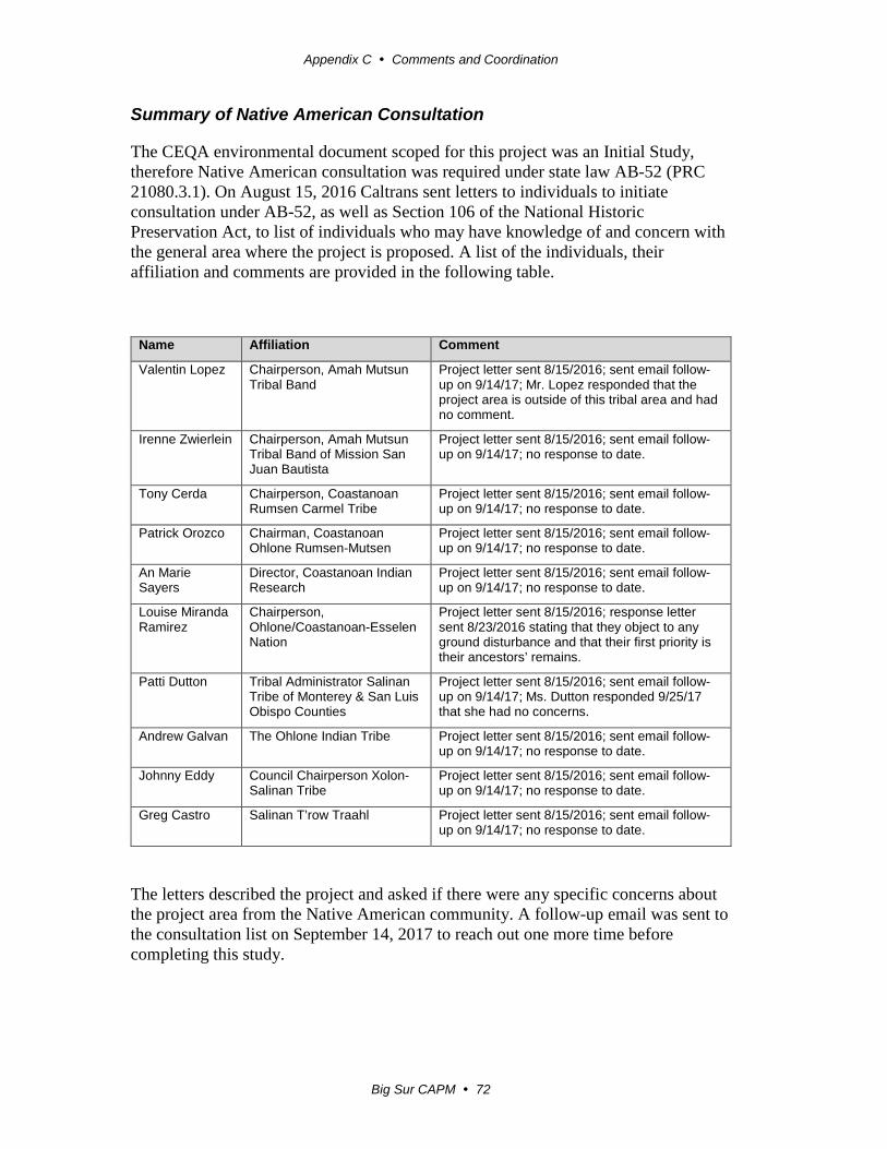
Appendix C Comments and Coordination
Big Sur CAPM 72
Summary of Native American Consultation
The CEQA environmental document scoped for this project was an Initial Study, therefore Native American consultation was required under state law AB-52 (PRC 21080.3.1). On August 15, 2016 Caltrans sent letters to individuals to initiate consultation under AB-52, as well as Section 106 of the National Historic Preservation Act, to list of individuals who may have knowledge of and concern with the general area where the project is proposed. A list of the individuals, their affiliation and comments are provided in the following table.
Name Affiliation Comment
Valentin Lopez Chairperson, Amah Mutsun Tribal Band
Project letter sent 8/15/2016; sent email follow-up on 9/14/17; Mr. Lopez responded that the project area is outside of this tribal area and had no comment.
Irenne Zwierlein Chairperson, Amah Mutsun Tribal Band of Mission San Juan Bautista
Project letter sent 8/15/2016; sent email follow-up on 9/14/17; no response to date.
Tony Cerda Chairperson, Coastanoan Rumsen Carmel Tribe
Project letter sent 8/15/2016; sent email follow-up on 9/14/17; no response to date.
Patrick Orozco Chairman, Coastanoan Ohlone Rumsen-Mutsen
Project letter sent 8/15/2016; sent email follow-up on 9/14/17; no response to date.
An Marie Sayers
Director, Coastanoan Indian Research
Project letter sent 8/15/2016; sent email follow-up on 9/14/17; no response to date.
Louise Miranda Ramirez
Chairperson, Ohlone/Coastanoan-Esselen Nation
Project letter sent 8/15/2016; response letter sent 8/23/2016 stating that they object to any ground disturbance and that their first priority is their ancestors’ remains.
Patti Dutton Tribal Administrator Salinan Tribe of Monterey & San Luis Obispo Counties
Project letter sent 8/15/2016; sent email follow-up on 9/14/17; Ms. Dutton responded 9/25/17 that she had no concerns.
Andrew Galvan The Ohlone Indian Tribe Project letter sent 8/15/2016; sent email follow-up on 9/14/17; no response to date.
Johnny Eddy Council Chairperson Xolon-Salinan Tribe
Project letter sent 8/15/2016; sent email follow-up on 9/14/17; no response to date.
Greg Castro Salinan T’row Traahl Project letter sent 8/15/2016; sent email follow-up on 9/14/17; no response to date.
The letters described the project and asked if there were any specific concerns about the project area from the Native American community. A follow-up email was sent to the consultation list on September 14, 2017 to reach out one more time before completing this study.

Appendix C Comments and Coordination
Big Sur CAPM 73
Consultation was carried out with tribal members who are known to have connections and/concerns for the project area. The list of representative was approved by the Caltrans District 5 Native American Coordinator, Terry Joslin. Two tribal members responded to Caltrans’ consultation request. Louise Miranda Ramirez responded to the August 15, 2016 letter stating that they have general concerns for all construction projects within their tribal territory, but provided no specific information about any areas of concern and did not request consultation under PRC 21080.3.1. Valentin Lopez responded to the September 14, 2017 email to say that the project area is outside of this traditional tribal area.
It is Caltrans policy that if cultural materials are encountered during construction all work would stop until a qualified archaeologist can evaluate the situation. If intact cultural materials are present, then procedures for Post-Review Discoveries would be followed (2014 Section 106 PA XV) and Native American monitors would be involved with further archaeological studies.
Summary of Biological Coordination
November 22, 2016: Caltrans Biologist John Moule generated a project species list from the CNDDB using the CDFW Rarefind5 internet application tool. Mr. Moule also submitted a request online through the USFWS Information Planning and Consultation (IPaC) website for an official USFWS species list. IPaC generated a list the same day. Mr. Moule also generated a list of California rare plant species for the project using the California Native Plant Society’s Online Inventory of Rare and Endangered Plant Species.
March 15, 2017: Mr. Moule updated the CNDDB and USFWS species lists.
August 23 2017: Mr. Moule updated the CNDDB and USFWS species lists.
January 8, 2018: Mr. Moule contacted Rick Farris at the USFWS to inquire about submitting requests for the project’s inclusion under the Smith’s blue butterfly and California red-legged frog programmatic biological opinions (PBOs).
January 11, 2018: Mr. Farris replied that the PBO requests should be sent to Christopher Diel at USFWS Ventura office.
January 18, 2018: Mr. Moule emailed the PBO requests to Christopher Diel.
January 24, 2018: Mr. Diel emailed Mr. Moule asking for hard copies of the PBO requests.
January 25, 2018: Mr. Moule mailed hard copies of the PBO requests to Mr. Diel.
January 29, 2018: Mr. Diel emailed Mr. Moule to conform the hard copies had been received.

Appendix C Comments and Coordination
Big Sur CAPM 74
March 1, 2018: Mr. Moule emailed Mr. Diel to inquire on the status of the PBO requests since it had been over 30 days and a complete submission letter had not been received. Mr. Diel replied that the requests had recently been assigned to Karen Sinclair.
March 7, 2018: Mr. Moule generated a NMFS species list using their Google Earth online tool and updated the CNDDB and USFWS species lists.
March 14, 2018: Mr. Moule contacted Karen Sinclair to inquire on the status of the PBO requests. Ms. Sinclair replied that the requests were still being processed.
March 28, 2018: Mr. Moule received an approval letter from the USFWS stating that “the Caltrans Big Sur CAPM Project is consistent with and appropriate for inclusion under both PBOs.”

Big Sur CAPM 75
Appendix D List of Preparers
This document was prepared by the following Caltrans Central Region staff:
Alhabaly, Allam. Transportation Engineer. B.S., California State University, Fresno, School of Engineering; 15 years of experience in environmental technical studies, with emphasis on noise studies. Contribution: Air and Noise Studies.
Carr, Robert. Associate Landscape Architect. B.S., Landscape Architecture, California Polytechnic University, San Luis Obispo; 20 years of experience preparing Visual Impact Assessments. Contribution: Visual Impact Assessment.
Fowler, Matt. Senior Environmental Planner. B.A., Geographic Analysis, San Diego State University, 16 years of experience in environmental planning. Contribution: Oversight of the Initial Study.
Fuller, Brian. Project Engineer. B.S., Environmental Engineering, California Polytechnic University, San Luis Obispo; 15 years of experience in Civil Engineering. Contribution: Project Engineer, Transportation Engineer, Civil.
Geramaldi. Environmental Planner (Generalist). B.S. Environmental Geography, California Polytechnic State University, Pomona; 2 years of environmental planning experience. Contribution: Coordinated environmental process, prepared the Initial Study.
Kozub, Lindsay. Associate Environmental Planner (Architectural Historian). M.A., History/Cultural Resource Management, Colorado State University; B.A., History; B.S., Business; 8 years of experience in historical research and analysis, historic preservation, and cultural resource management. Contribution: Architectural History study, Historic Property Survey Report, Environmentally Sensitive Area (ESA) Action Plan for Historic Resources
Leyva, Isaac. Engineering Geologist. B.S., Geology, California State University, Bakersfield; A.S., Cuesta College, San Luis Obispo; 30 years of experience in petroleum geology, environmental, geotechnical engineering. Contribution: Initial Site Assessment, Paleontology Technical Report, Water Quality Assessment.
MacDonald, Christina. Associate Environmental Planner (Archeology). M.A., Cultural Resources Management, Sonoma State University; B.A., Anthropology, University of California, Los Angeles; 20 years of experience in California prehistoric and historical archaeology. Contribution: Archeological Study Report, Historic Property Survey Report, Environmentally Sensitive Area (ESA) Action Plan for Archeological Resources.

Appendix D List of Preparers
Big Sur CAPM 76
Moule, John. Consultant Associate Biologist/Environmental Planner. B.S., Biology, Humboldt State University; 22 years of natural resource and biology experience. Contribution: Natural Environmental Study – Minimal Impact.
Schefter, Edward. Senior Transportation Surveyor, GIS Specialist. B.S. Surveying & Photogrammetry, Fresno State University. 15 years of land surveying and 15 years GIS experience. Contribution: Environmentally Sensitive Area (ESA) Action plan.
Yu, Carla. Project Manager. P.E., B.S. Civil Engineering, California Polytechnic State University, San Luis Obispo; 17 years of experience in structural, civil and transportation engineering. Contribution: Project Manager.

Big Sur CAPM 77
Appendix E Distribution List
Monterey County Planning Office 1441 Schilling Place Salinas, CA 93901 Monterey County Free Libraries:
• Buena Vista Branch 18250 Tara Drive Salinas, CA 93908
• Big Sur Branch Highway-1 at Ripplewood Resort Big Sur, CA 93920
• Carmel Valley Branch 65 West Carmel Valley Road Carmel Valley, CA 93924
Transportation Agency of Monterey County (TAMC) 55-B Plaza Circle Salinas, CA 93901 Velo Club Monterey P.O. Box 1404 Monterey, CA 93942 California Department of Parks and Recreation – Monterey District 2211 Garden Road Monterey, CA 93940 California Department of Fish and Wildlife – Central Region 1234 E. Shaw Avenue Fresno, CA 93710 California Coastal Commission – Central Coast District 725 Front Street Suite 200 Santa Cruz, CA 95060

Appendix E Distribution LIst
Big Sur CAPM 78
This page left intentionally blank

Big Sur CAPM 79
Appendix F Title VI Policy Statement

Appendix F Title VI Policy Statement
Big Sur CAPM 80
This page left intentionally blank
Big Sur CAPM 81
Appendix G State Clearinghouse Letter
Letter from the Governor’s Office of Planning and Research indicating Caltrans’ compliance with the State Clearinghouse review requirements.

Appendix G State Clearinghouse Letter
Big Sur CAPM 82
This page left intentionally blank

Appendix G State Clearinghouse Letter
Big Sur CAPM 83

Appendix G State Clearinghouse Letter
Big Sur CAPM 84

Big Sur CAPM 85
Appendix H Comments and Responses
No public comments were received for the Big Sur Capital Preventive Maintenance Project.
The Initial Study with Proposed Mitigated Negative Declaration was made available for public for review from January 25, 2018 to February 26, 2018. Hard copies of the document were made available at Caltrans District 5 Office, Monterey County Planning Office and Monterey County Free Libraries. Digital copies were made available on Caltrans District 5 website. A public notice announcing the availability of the document and the public comment period was printed in the Monterey County Herald.

Appendix H Comments and Responses
Big Sur CAPM 86
This page left intentionally blank

Big Sur CAPM 87
Appendix I U.S. Fish and Wildlife Service Letter of Concurrence

Appendix I U.S. Fish and Wildlife Service Letter of Concurrence
Big Sur CAPM 88
This page left intentionally blank

Appendix I U.S. Fish and Wildlife Service Letter of Concurrence
Big Sur CAPM 89
Appendix I U.S. Fish and Wildlife Service Letter of Concurrence
Big Sur CAPM 90
Appendix I U.S. Fish and Wildlife Service Letter of Concurrence
Big Sur CAPM 91

Appendix I U.S. Fish and Wildlife Service Letter of Concurrence
Big Sur CAPM 92
This page left intentionally blank

Big Sur CAPM 93
Appendix J 2018 USFWS Species List

Appendix J 2018 USFWS Species List
Big Sur CAPM 94
This page left intentionally blank

Appendix J 2018 USFWS Species List
Big Sur CAPM 95

Appendix J 2018 USFWS Species List
Big Sur CAPM 96

Appendix J 2018 USFWS Species List
Big Sur CAPM 97

Appendix J 2018 USFWS Species List
Big Sur CAPM 98

Appendix J 2018 USFWS Species List
Big Sur CAPM 99
Appendix J 2018 USFWS Species List
Big Sur CAPM 100

Appendix J 2018 USFWS Species List
Big Sur CAPM 101

Appendix J 2018 USFWS Species List
Big Sur CAPM 102
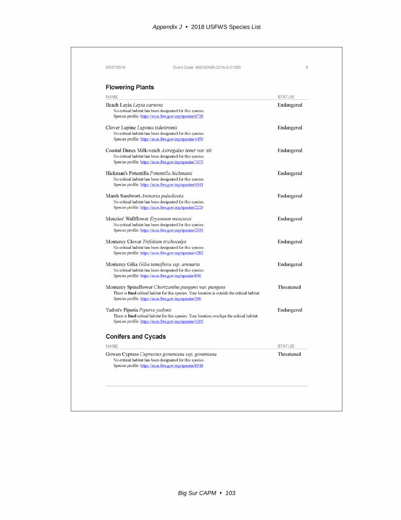
Appendix J 2018 USFWS Species List
Big Sur CAPM 103

Appendix J 2018 USFWS Species List
Big Sur CAPM 104

Big Sur CAPM 105
Appendix K 2018 NMFS Species List

Appendix K 2018 NMFS Species List
Big Sur CAPM 106
This page left intentionally blank

Appendix K 2018 NMFS Species List
Big Sur CAPM 107
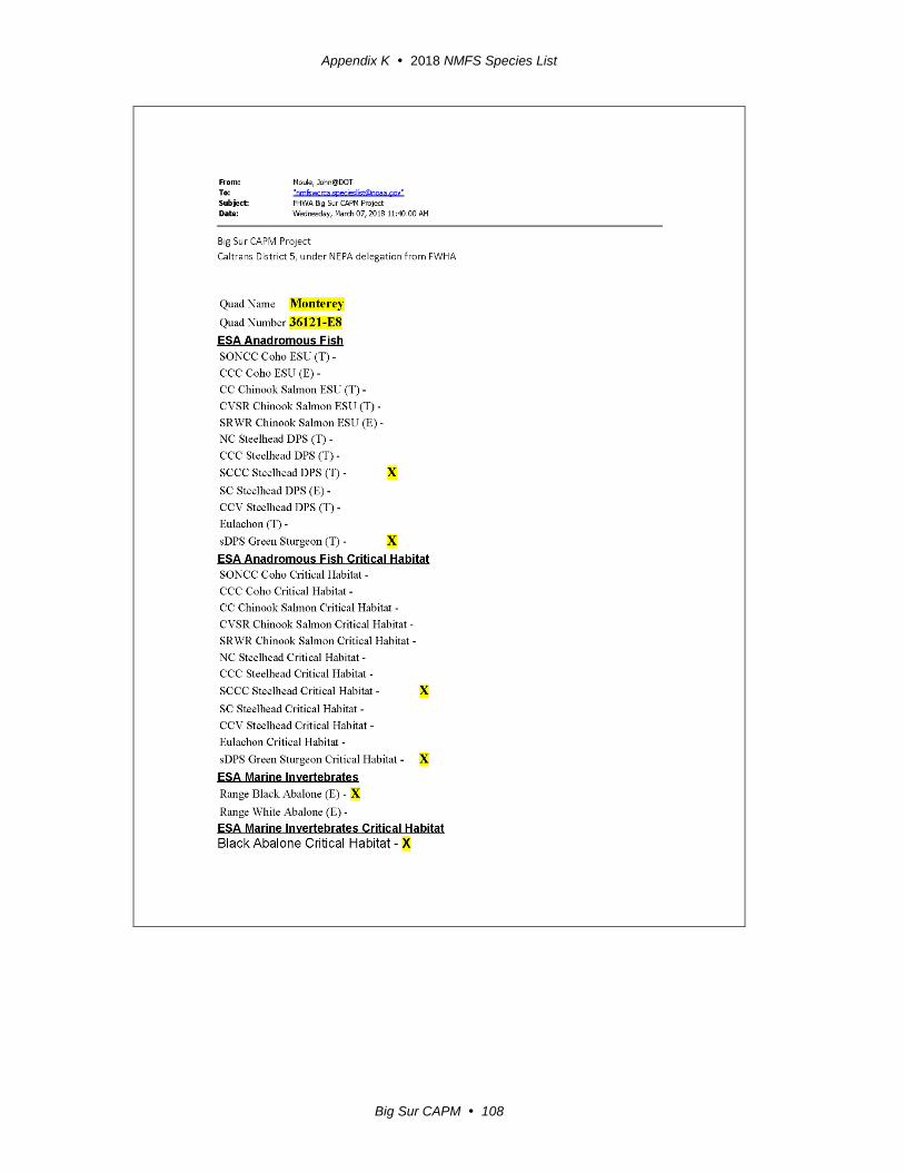
Appendix K 2018 NMFS Species List
Big Sur CAPM 108

Appendix K 2018 NMFS Species List
Big Sur CAPM 109

Appendix K 2018 NMFS Species List
Big Sur CAPM 110

Appendix K 2018 NMFS Species List
Big Sur CAPM 111

Appendix K 2018 NMFS Species List
Big Sur CAPM 112

Appendix K 2018 NMFS Species List
Big Sur CAPM 113

Appendix K 2018 NMFS Species List
Big Sur CAPM 114

Appendix K 2018 NMFS Species List
Big Sur CAPM 115
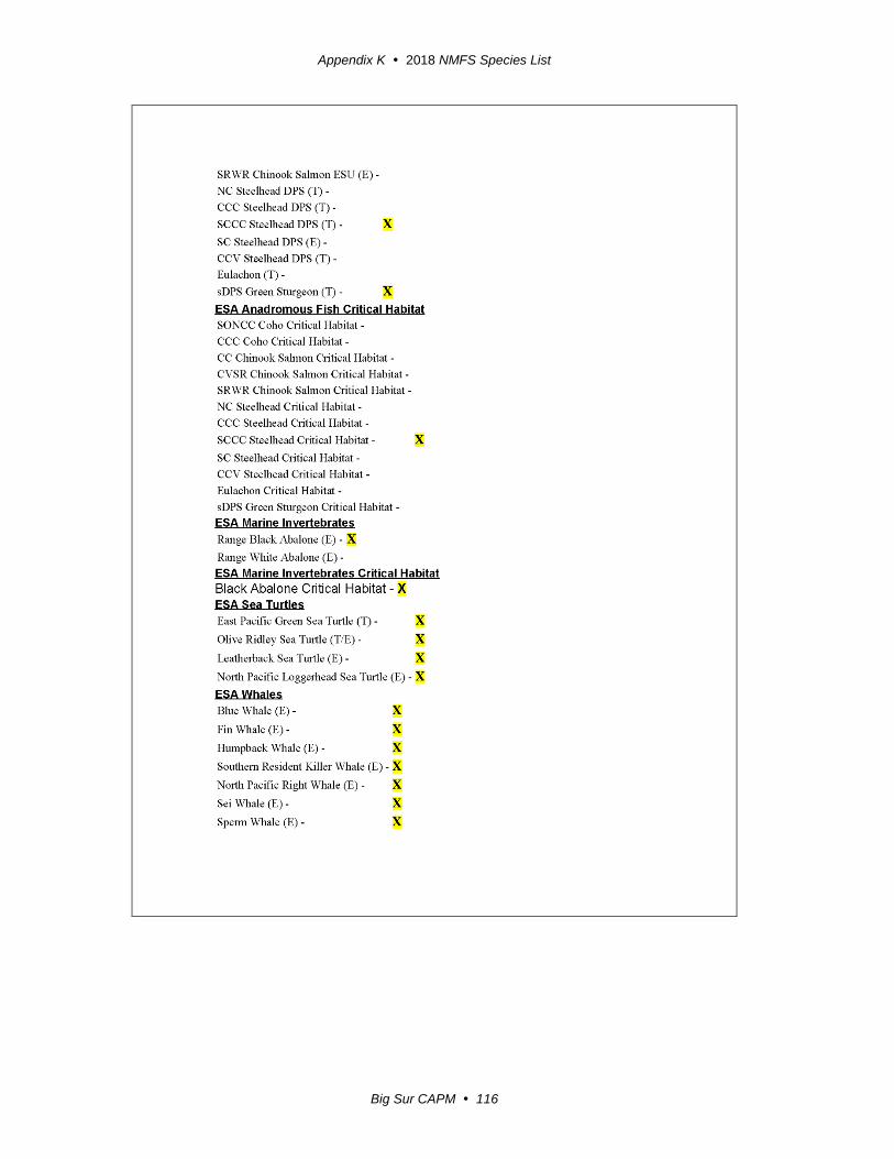
Appendix K 2018 NMFS Species List
Big Sur CAPM 116
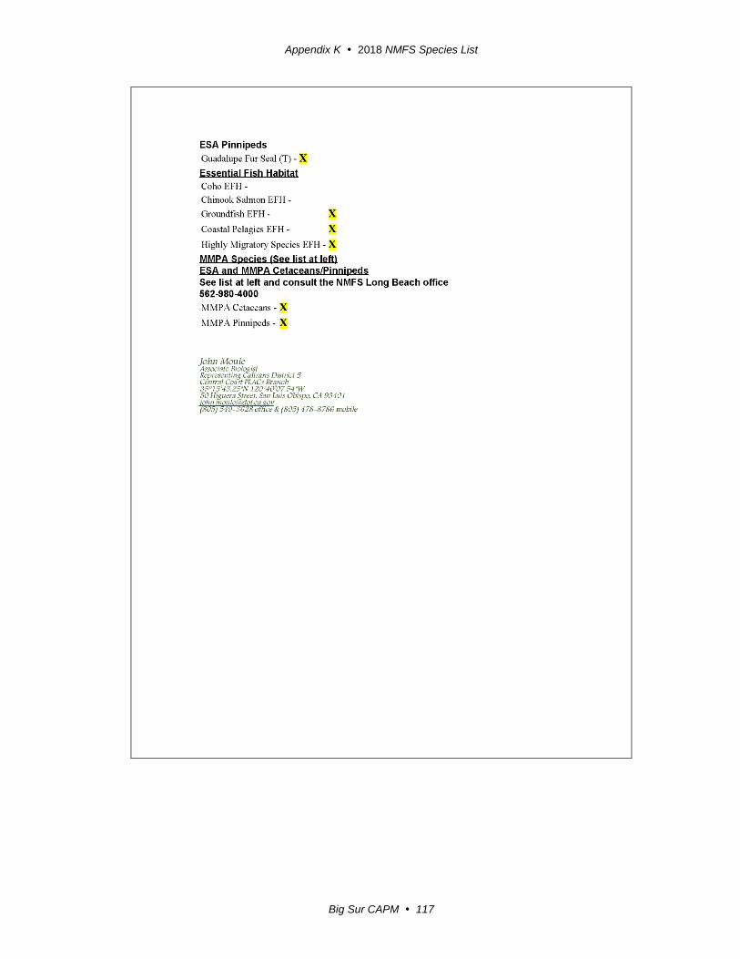
Appendix K 2018 NMFS Species List
Big Sur CAPM 117

Appendix K 2018 NMFS Species List
Big Sur CAPM 118
This page left intentionally blank

Big Sur CAPM 119
List of Technical Studies
Hazardous Waste Report, August 9, 2016
Paleontology Technical Report, August 9, 2016
Water Quality Assessment, August 9, 2016
Air Quality Report, August 9, 2017
Noise Study Report, August 9, 2017
Visual Impact Assessment, September 26, 2017
Natural Environment Study, October 24, 2017

Appendix K 2018 NMFS Species List
Big Sur CAPM 120
This page left intentionally blank