1 M-150 / Botts Rd Interchange MoDOT Project No. J4P2251 Pre-Bid Meeting June 24 th, 2010.
Upload
duongnguyetCategory
view
221download
4
Legal Description: Richland Township: Section 33 - Township 17 - Range 11, Washington County, Nebraska contain-ing 320 acres, more or less. (full legal description available upon request) METHOD OF SALE: Sealed Bid offers must be received by 3:00 p.m. CDT, Wednesday April 22nd, 2015 at WC Real Estate office, 710 S 19th Street, Blair, NE 68008 or by mail to P.O. Box 188, Blair, NE 68008. After review of offers, the top 3 bid-ders may be invited to participate in a final round “bid off” at sellers discretion. It will be announced on sale date if the pre-sent high offer has or will result in an absolute sale. It is sellers intent to sell but reserves the right to accept or reject any and all offers. AUCTION TERMS: Within 24 hours of notification, the successful bidder will be required to enter into a written purchase agreement along with lender pre-approval letter or proof of funds letter and a 10% earnest money payment payable in the form of personal, company check or certified cashiers check to “WC Real Estate”. The balance due payable at closing in cash, guaranteed funds or by wire transfer. Seller will provide marketable title to Buyer, evidenced by a policy of Title Insur-ance. Cost of Title Insurance and escrow closing services provided by Blair Abstract and Title will be divided equally be-tween Seller and Buyer. Property will NOT be sold subject or contingent to financing. Please have all financial arrangements made prior to submitting sealed bid. Announcements made on website: wcFarmDivision.com the day of the auction takes precedence over previous announcements and printed materials. The information provided is deemed reliable. We have no reason to doubt its accuracy, but do not guarantee it. CONDITIONS: Closing date to be agreed upon. Possession date March 1st, 2016. This sale maybe subject to easements, covenants, leases and restrictions of record. Each bidder is responsible for conducting, at their own risk, their own inspec-tions, inquiries, and due diligence concerning the property. Past history is no guarantee of future performance. All property is sold “as is - where is” with no warranties or guarantees, expressed or implied, by the owner or agents of WC Real Estate. SELLER: K & BB Farms, LLC
If you need additional information, please call…
Kevin Kermeen - Broker cell direct (402) 657-9656
FARM LAND AUCTION BID FORM
Property Address: SW corner of Co Rd 29 & Co Rd 40, Bennington, NE
Sealed Bid offers must be received by 3:00 p.m. CDT, Wednesday April 22nd, 2015
In person at WC Real Estate office, 710 S 19th Street, Blair, NE 68008 or by mail to P.O. Box 188, Blair, NE 68008
BID Per Acre: $_________________________
Preferred Closing Date: _______________________
Do you have a 1031 Exchange to use in this transaction? YES or NO
BIDDER NAME:_______________________________________________
By:__________________________________________ Date:__________ (Signature of Bidder or Bidder Representative) Address:____________________________________________________ City:______________________________ State:_____ Zip:___________ Phone:_____________________ (Home) ______________________(Cell)
All information to be completed to be considered a valid bidder.

BROKER: Kevin Kermeen Cell Direct: 402-657-9656
WASHINGTON County, NE
Description: Tillable farmland for sale. (AUCTION - NEW LISTING)
Richland Township, Section 33 - Township 17 - Range 11, Bennington, NE
Total Acres: 320 +/- Tillable Acres: 297.45 +/- (per FSA) Possession: March 1st, 2016 Irrigated: No Price: Auction - April 22nd Price per acre: Auction - April 22nd Topography: Rolling Property Type: Tillable
Directions: Southwest corner of Co Rd 29 & 40
Signs on property: No
Method of Sale: Sealed Bid Auction - offers must be received by 3:00 p.m. CDT, Wednesday April 22nd, 2015.
Improvements: Terraces and 2 Grain Bins
Taxes: $21,390.82
Questions? Contact Kevin Kermeen - Broker Cell Direct: 402-657-9656
FARMS | LIVE AUCTIONS | SEALED BID AUCTIONS | LAND RENT AUCTIONS | REC-LAND
FARM LAND FOR SALE
Information deemed reliable but not guaranteed


Washington CountyNebraska
3/4/2015
map center: 41° 24' 18.94, 96° 11' 5.63
scale: 9588
Aerial Map
33-17N-11E
Field borders provided by Farm Service Agency as of 5/21/2008. Aerial photography provided by Aerial Photography Field Office.

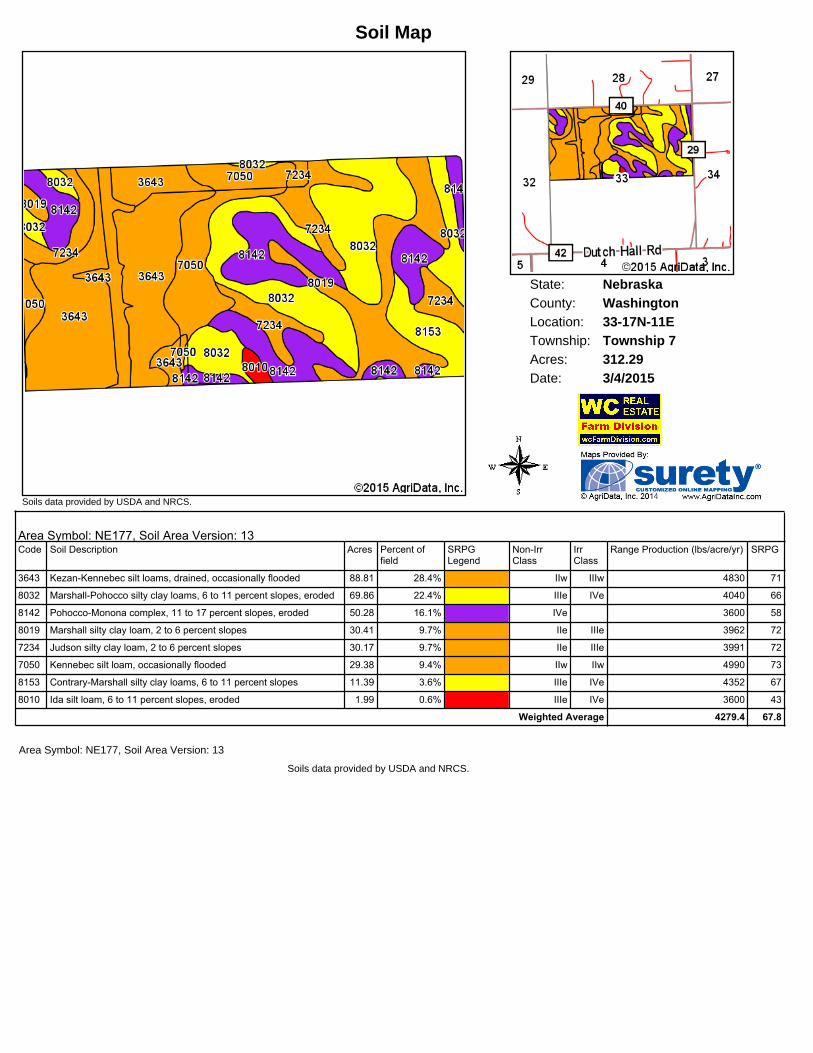
State: NebraskaWashingtonCounty:33-17N-11ELocation:
Township: Township 7Acres: 312.29Date: 3/4/2015
Soils data provided by USDA and NRCS.
Soil Map
Area Symbol: NE177, Soil Area Version: 13Code Soil Description Acres Percent of
fieldSRPGLegend
NonIrrClass
IrrClass
Range Production (lbs/acre/yr) SRPG
3643 KezanKennebec silt loams, drained, occasionally flooded 88.81 28.4% IIw IIIw 4830 71
8032 MarshallPohocco silty clay loams, 6 to 11 percent slopes, eroded 69.86 22.4% IIIe IVe 4040 66
8142 PohoccoMonona complex, 11 to 17 percent slopes, eroded 50.28 16.1% IVe 3600 58
8019 Marshall silty clay loam, 2 to 6 percent slopes 30.41 9.7% IIe IIIe 3962 72
7234 Judson silty clay loam, 2 to 6 percent slopes 30.17 9.7% IIe IIIe 3991 72
7050 Kennebec silt loam, occasionally flooded 29.38 9.4% IIw IIw 4990 73
8153 ContraryMarshall silty clay loams, 6 to 11 percent slopes 11.39 3.6% IIIe IVe 4352 67
8010 Ida silt loam, 6 to 11 percent slopes, eroded 1.99 0.6% IIIe IVe 3600 43
Weighted Average 4279.4 67.8
Area Symbol: NE177, Soil Area Version: 13
Soils data provided by USDA and NRCS.