BGP PIONEER Technical Specificationsenernews.com/media/briefs/bgp-pionner-el-barco... · 1.2...
26
BGP PIONEER Technical Specifications Presented by BGP 2014
Transcript of BGP PIONEER Technical Specificationsenernews.com/media/briefs/bgp-pionner-el-barco... · 1.2...
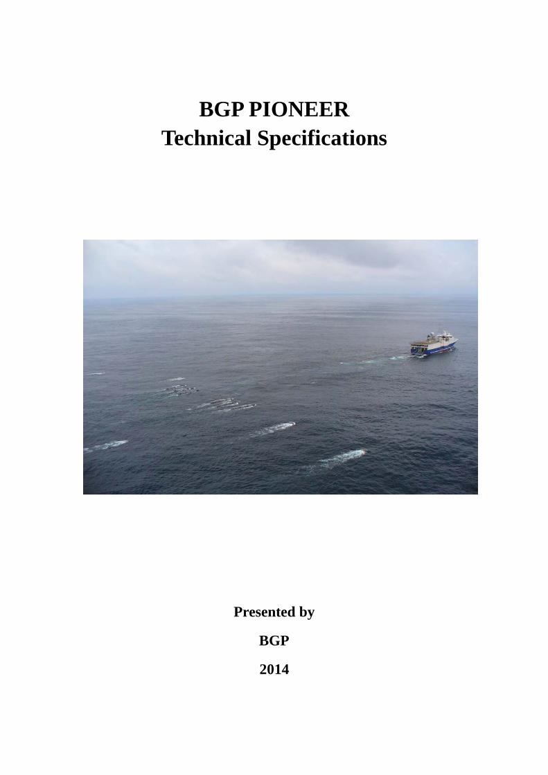
BGP PIONEER
Technical Specifications
Presented by
BGP
2014
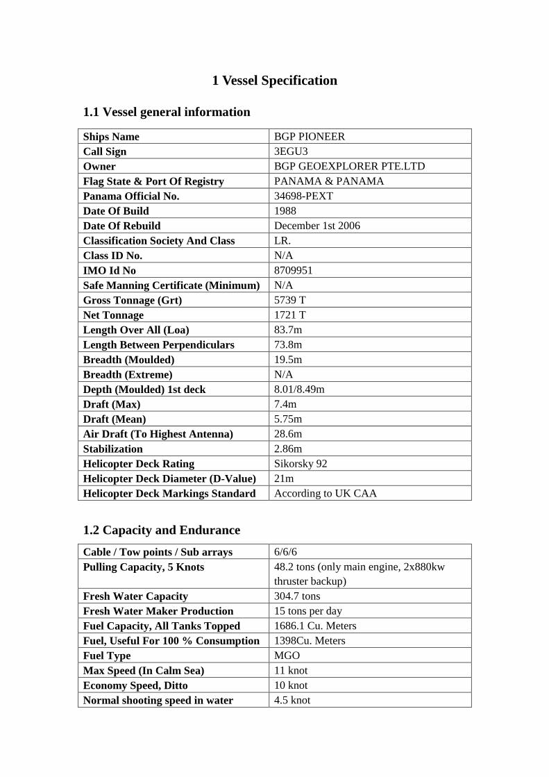
1 Vessel Specification
1.1 Vessel general information
Ships Name BGP PIONEER Call Sign 3EGU3 Owner BGP GEOEXPLORER PTE.LTD Flag State & Port Of Registry PANAMA & PANAMA Panama Official No. 34698-PEXT Date Of Build 1988 Date Of Rebuild December 1st 2006 Classification Society And Class LR. Class ID No. N/A IMO Id No 8709951 Safe Manning Certificate (Minimum) N/A Gross Tonnage (Grt) 5739 T Net Tonnage 1721 T Length Over All (Loa) 83.7m Length Between Perpendiculars 73.8m Breadth (Moulded) 19.5m Breadth (Extreme) N/A Depth (Moulded) 1st deck 8.01/8.49m Draft (Max) 7.4m Draft (Mean) 5.75m Air Draft (To Highest Antenna) 28.6m Stabilization 2.86m Helicopter Deck Rating Sikorsky 92 Helicopter Deck Diameter (D-Value) 21m Helicopter Deck Markings Standard According to UK CAA
1.2 Capacity and Endurance Cable / Tow points / Sub arrays 6/6/6 Pulling Capacity, 5 Knots 48.2 tons (only main engine, 2x880kw
thruster backup) Fresh Water Capacity 304.7 tons Fresh Water Maker Production 15 tons per day Fuel Capacity, All Tanks Topped 1686.1 Cu. Meters Fuel, Useful For 100 % Consumption 1398Cu. Meters Fuel Type MGO Max Speed (In Calm Sea) 11 knot Economy Speed, Ditto 10 knot Normal shooting speed in water 4.5 knot
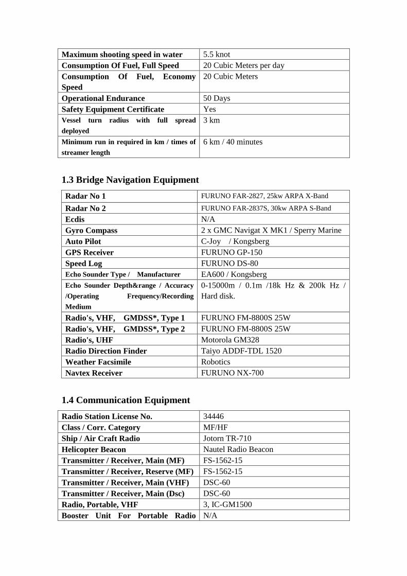
Maximum shooting speed in water 5.5 knot Consumption Of Fuel, Full Speed 20 Cubic Meters per day Consumption Of Fuel, Economy Speed
20 Cubic Meters
Operational Endurance 50 Days Safety Equipment Certificate Yes Vessel turn radius with full spread deployed
3 km
Minimum run in required in km / times of streamer length
6 km / 40 minutes
1.3 Bridge Navigation Equipment Radar No 1 FURUNO FAR-2827, 25kw ARPA X-Band
Radar No 2 FURUNO FAR-2837S, 30kw ARPA S-Band Ecdis N/A Gyro Compass 2 x GMC Navigat X MK1 / Sperry Marine Auto Pilot C-Joy / Kongsberg GPS Receiver FURUNO GP-150 Speed Log FURUNO DS-80 Echo Sounder Type / Manufacturer EA600 / Kongsberg Echo Sounder Depth&range / Accuracy /Operating Frequency/Recording Medium
0-15000m / 0.1m /18k Hz & 200k Hz / Hard disk.
Radio's, VHF, GMDSS*, Type 1 FURUNO FM-8800S 25W Radio's, VHF, GMDSS*, Type 2 FURUNO FM-8800S 25W Radio's, UHF Motorola GM328 Radio Direction Finder Taiyo ADDF-TDL 1520 Weather Facsimile Robotics Navtex Receiver FURUNO NX-700
1.4 Communication Equipment
Radio Station License No. 34446 Class / Corr. Category MF/HF Ship / Air Craft Radio Jotorn TR-710 Helicopter Beacon Nautel Radio Beacon Transmitter / Receiver, Main (MF) FS-1562-15 Transmitter / Receiver, Reserve (MF) FS-1562-15 Transmitter / Receiver, Main (VHF) DSC-60 Transmitter / Receiver, Main (Dsc) DSC-60 Radio, Portable, VHF 3, IC-GM1500 Booster Unit For Portable Radio N/A

(VHF) Emergency Radio Beacon (Epirb) MRB 3 Radar Transponder 2, SART 9.2-9.5GHz Radio, Lifeboat, VHF FURUNO FM-3000 25W
1.5 Satellite Communications Inmarsat Type B TT-3022D Thrane&Thrane Inmarsat Type C TT-3020B Thrane&Thrane VSAT 9797A Seatel Inm.Sat.F Teleph. / Fax. No. 337 172911 Norsat-C. Online Tele Link to Oslo Yes Telefax Machine Telecom (brother) Internal E-Mail & Pc-Network Yes Iridium Type: Marconi THRANE&THRANE S/N07953185 E-Mail Address To Vessel [email protected]
1.6 Safety Equipment Crew
Lifeboat Type / Capacity/ No. Of Boats
Norsafe Mako 655 waterjet 164 HP
Engine, Lifeboat Cummins 164 HP Life rafts Type /Capacity Viking Life raft, 25DFK davit
launchable/25 men Life raft Davits N/A at present Number Of Life Rafts 8 Lifejackets 120 pc Survival Suits, Thermo Insulated 60 pc Fast Rescue Boat (FRC) Type Norsafe Engine And Speed Of Boat 164 HP Cummins, Minimum 20 knots Water jet And Gear Drive Water jet Work Boat Norpower 1x 25ft workboat Engine Work Boat and Speed of Boat 180 HP Cummins diesel engine with
Nogva gear AGF-1131, and pitch propeller /23knots
1.7 Fixed Fire Extinguisher System Engine Room
Main CO2 deluge, 45L*2+40L AFFF Water Mist deluge*6
Compressor Room
Main CO2 deluge, 45L*3+40L AFFF Water Mist deluge*13

Incinerator Room
Main CO2 deluge*2 Water Mist deluge*1
Galley Ducting CO2 Cable Store Main CO2 deluge*10 + hydrants Steamer Winch Room AFFF fixed deluge + hydrants Helicopter Deck MobilCO2*1, Power 2, Main FOAM
deluge*2 Paint Store Water Mist deluge*3 Chemical Store Water Mist deluge*3 Main Foam Pump, AFFF Foam Mixture
30m3/hr 12bar
Main Fire Pump 2x40/135m3/hr 6/4bar Emergency Fire Pump 40m3/hr 7bar Fire Detection Monitoring System Autronica AUTRO SAFE BS-30
1.8 Hull Outfitting Decks Crane 1, Capacity/Reach/Location
2 ton /6m/Front Deck
Decks Crane 2, Capacity/Reach/Location
8 ton/18m/ Helicopter Deck and Middle deck
Decks Crane 3, Capacity/Reach/Location
N/A
Crew Accommodation, No Of Bunks 60 Single Berths Cabins 32 Double Berths Cabins 14 Conference And Training Rm 1+1 Sauna And Fitness Room 1+2
1.9 International Oil Pollution Prevention (IOPP) Equipment Incinerator, Sludge And Waste Oil OGS-200C Bilge / Oily Water Separator Heli-Sep Model 1000 Oily Water / Sludge Holding Tanks Cap. 6.8cu.m Oil Spill Absorbent / Damage Control Yes
1.10 Machinery Equipment
Air Source, Compressors LMF51/138-207-D Air Capacity 3X51M3/min Hp Compressor Drive Motors CAT 3512B Main Engine 1 x Wichmann 12V28B Diesel,
3960Kw/ 620 r/min Auxiliary Engines (Generator Drive) 2 x Caterpillar 3516B
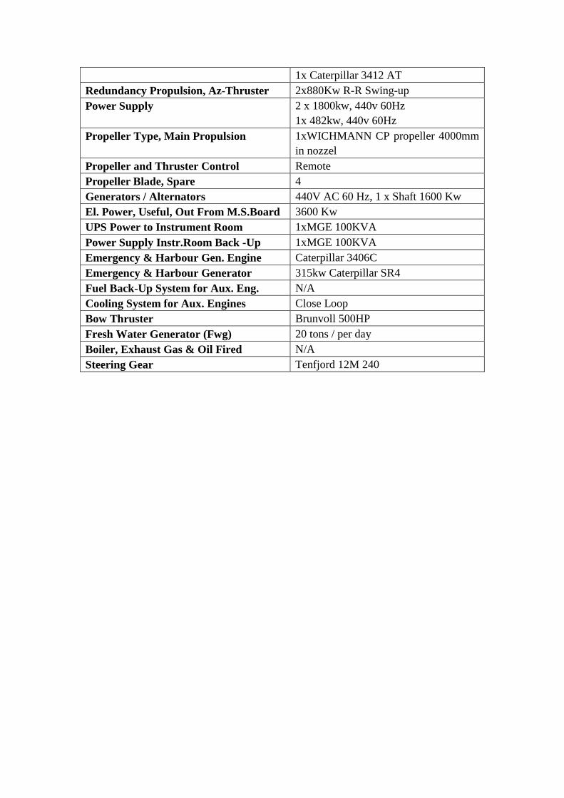
1x Caterpillar 3412 AT Redundancy Propulsion, Az-Thruster 2x880Kw R-R Swing-up Power Supply 2 x 1800kw, 440v 60Hz
1x 482kw, 440v 60Hz Propeller Type, Main Propulsion 1xWICHMANN CP propeller 4000mm
in nozzel Propeller and Thruster Control Remote Propeller Blade, Spare 4 Generators / Alternators 440V AC 60 Hz, 1 x Shaft 1600 Kw El. Power, Useful, Out From M.S.Board 3600 Kw UPS Power to Instrument Room 1xMGE 100KVA Power Supply Instr.Room Back -Up 1xMGE 100KVA Emergency & Harbour Gen. Engine Caterpillar 3406C Emergency & Harbour Generator 315kw Caterpillar SR4 Fuel Back-Up System for Aux. Eng. N/A Cooling System for Aux. Engines Close Loop Bow Thruster Brunvoll 500HP Fresh Water Generator (Fwg) 20 tons / per day Boiler, Exhaust Gas & Oil Fired N/A Steering Gear Tenfjord 12M 240

2 Streamer Specification
2.1 Streamer System
Type Sercel Sentinel Solid Capacity 6x480 Channels No Of Streamers 6x6000m Spread 100mx5 Deflector Type Barovane Type of tailbuoy Seamap
2.2 Cable Specification
Minimum Group Interval 12.5m Hydrophones per Group 8 Nominal Group Sensitivity 19.7V/Bar open circuit @ 1 bar @ 20°C Nominal Group Capacitance 278 nF @ 22°C Transformer less/Digital 24 Maximum No. of Group Up to 640 per streamer Type & No. of depth Indicator Compass bird 5011E No. of water break amplifiers 6x1 Hydrophone Sercel Flexible Hydrophone Section Length 150m Active Cable Length 6000m Cable Oil ISOPAR M Cable Skin Polyurethane Breaking Strength 30000lb Cable Quality Control system Digicouse System 3
2.3 Electronic Module Module Type SERCEL-FRANCE INC Data Channels per Module 60 Channels Sample Rate 0.25 ,0.5 ,1 ,2 ,4ms Low Cut Filter 3Hz@6db/Octave High Cut Filter 200Hz@370dB/Octave Pre-Amplifier 0db ,12db Digitization 24 Bits Instant Dynamic Range 124db Gain Accuracy <0.1% Total Harmonic Distortion <-105db (0.005%) Crosstalk >100db Data Transmission Fiber optic in Lead-in Electronic in cable

2.4 Streamer Compass and Depth Control Type IO DIGICOURSE COMPASS BIRD-5011E Accuracy 0.1o Depth Sensor MODEL 483 Depth Accuracy 0.1m
2.5 Streamer lateral control Manufacturer ION, U.S.A
Model 5120 DigiFIN
PhysPhysical Characteristics
Length 1.3m(52 in) Weight in air 13.1kg(29 lbs)
Weight in water with batteries Netural Mounting
Industry-standard collars on(quickCUFF)
Communications Type Serial FSK Frequency 26kHz Data rate 2400 bit/s
Depth Measurement Operating Range 0 m to 122 m(0 ft to 400ft)
Commands 0.15m(0.5ft)
Lateral Performance Streamer feathering correction for typical seismic surveys
2°-3°
Acoustic Measurement Accuracy
0.1ms Resolution 0.05ms Number of ranges per network 2,800 ranges per system Maximum Range 1,200 Range received per device 8
Acoustic capability DigiRANGE II acoustic technology;Compatible with current CMX,CTX,AND 5110 Acoustic products
Battery SLB-150 Battery Pack
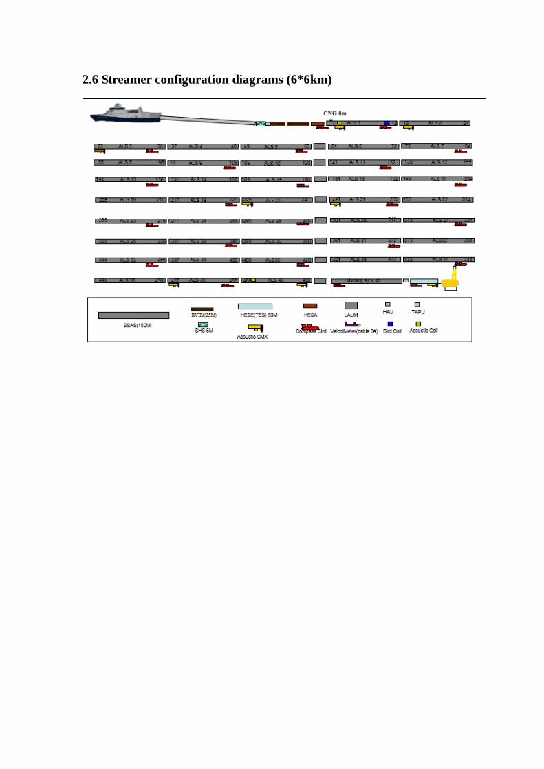
2.6 Streamer configuration diagrams (6*6km)
3 Recording Systems
3.1 Recording System Specifications Type SERCEL SEAL System MAX NO OF CHANNELS AT 2ms 960 channels/Streamer Maximum Auxiliary Channels 48 Maximum Record Length 90 seconds Filter: Lo-cut; Hi-cut 3Hz / 200Hz Type Gain Fixed Preamp Gain 0/12 db Dynamic 136db Data acquisition Quality Control ESQC-Pro Recycle Time 0 Trace Summing 6*640(six streamers) Recording Format SEG-D Recording Media & Transports Tape 3592 / A&B model Recording Device IBM3592 Multi Trace Plotter V24 / I SYS
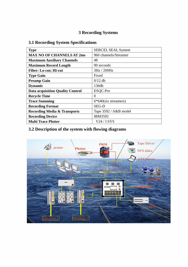
3.2 Description of the system with flowing diagrams

3.3 Instrument Room Layout

4 Source
4.1 Source Specification Gun Type G-GUN / Sercel Pressure Release 2000PSI-3000PSI Sensor Return Yes Compressor Capacity 3x51 (m3/min) Nominal Source Pressure 2000PSI-3000PSI Gun Controller Bigshot Timing Resolution 0.1ms Near Field Phones AGH 7100C Depth Indicators AGH 33M3 High Pressure Indicator AGH 33M4 Operating Source Volume 2 X 3370in3 (changeable as needed) Number of Air guns / Spare Guns 72 / 12 Out of Array 2 Subarray Separation 10m +/-2m Source Separation as specified Subarray Length 16m Minimum Compressor Recycle Time 6s Depth Range 5-6m (or as specified) No. of Depth Indicator 12 Source Quality Control System BigShot System 4.2 Gun Diagram
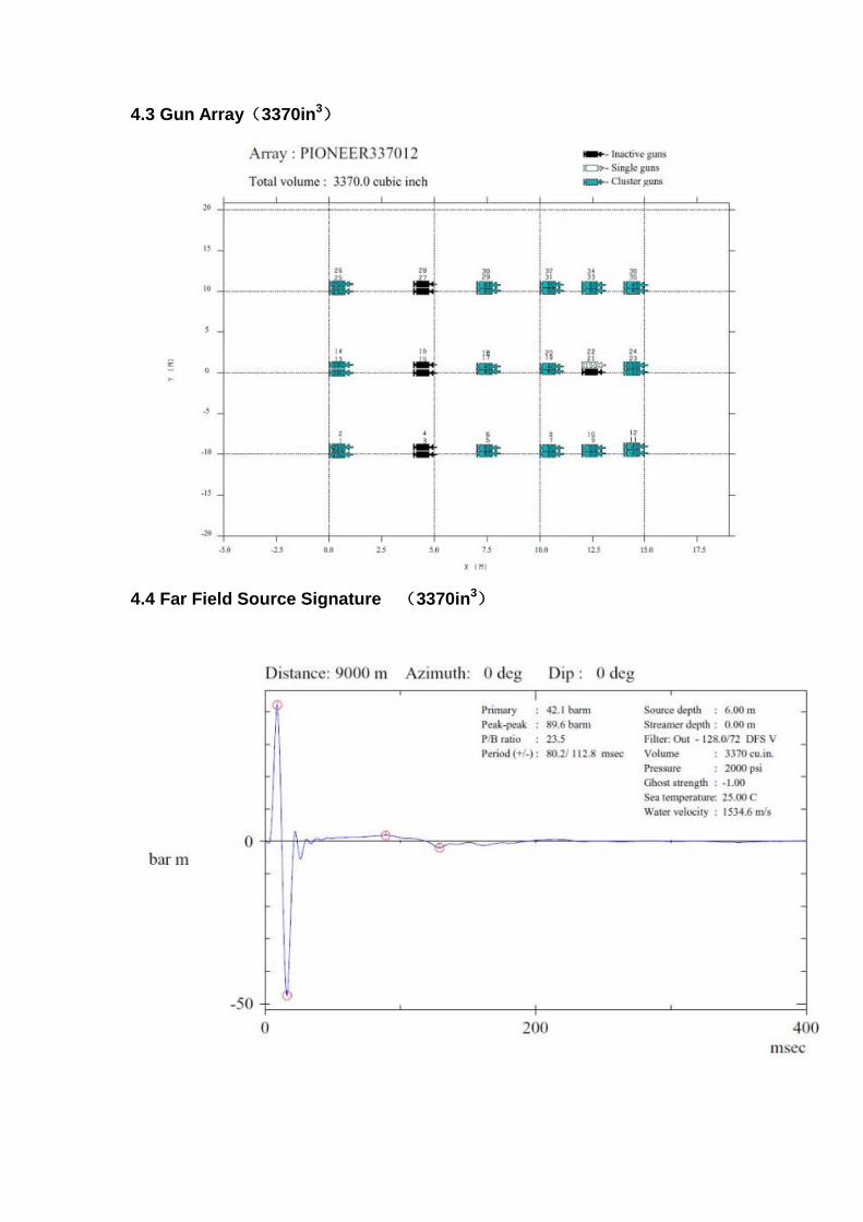
4.3 Gun Array(3370in3)
4.4 Far Field Source Signature (3370in3)

4.5 Amplitude spectrum of far-field signature of array(3370in3)
4.6 Source Directivity Plot-azimuth: 0 degree(3370in3)
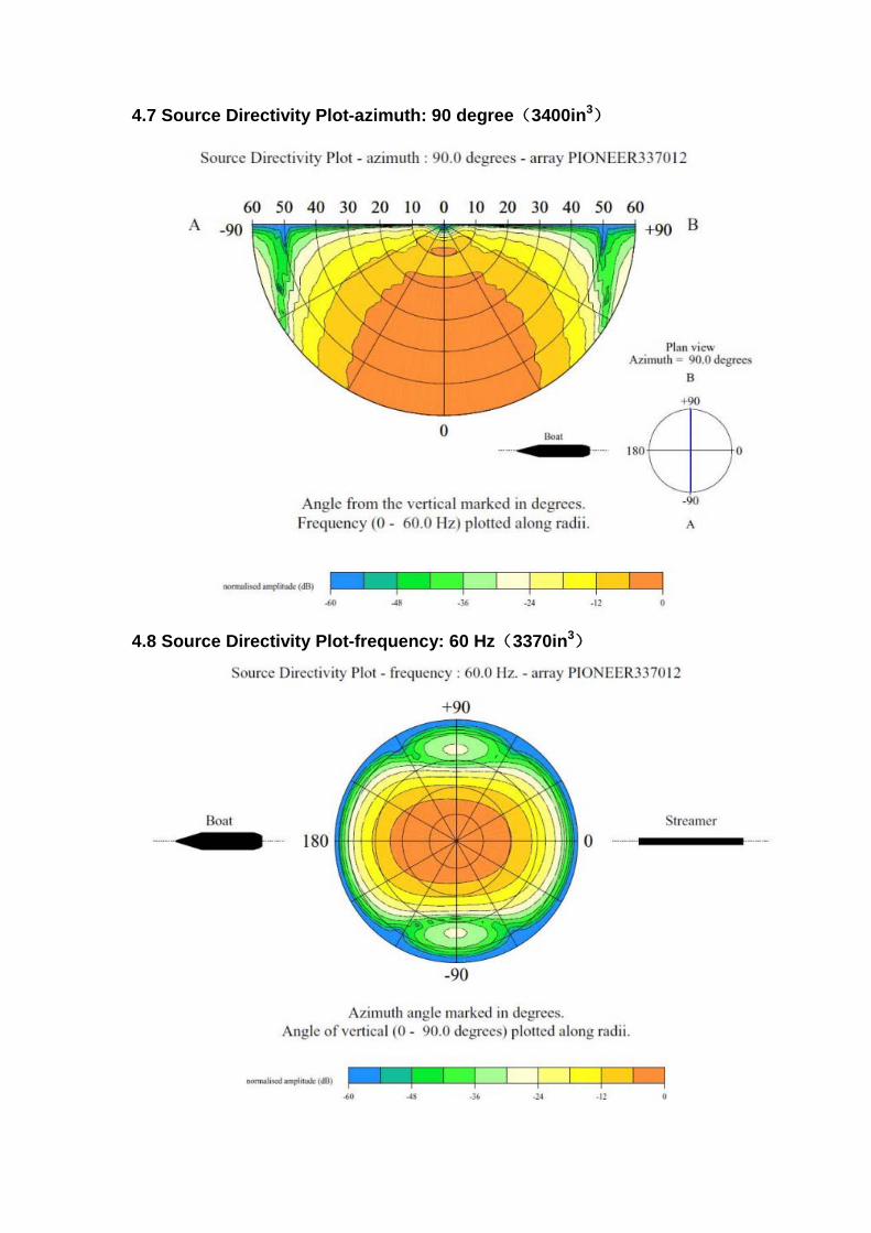
4.7 Source Directivity Plot-azimuth: 90 degree(3400in3)
4.8 Source Directivity Plot-frequency: 60 Hz(3370in3)
5 Navigation System 5.1 CONCEPT INTEGRATED NAVIGATION SYSTEM SPECTRA is an integrated navigation system for marine geophysical surveys. SPECTRA can handle any current survey configuration. This ranges from 2D single vessel to 3D multi-vessel, multi-streamer. SPECTRA's main features are: ♦ Navigation data acquisition and validation, performed by a powerful data
acquisition and control system. Sensor data acquisition and control functions are timed to a high resolution using GPS time standard.
♦ Shot prediction and header output. ♦ Real time source and streamer positioning, supporting multi-vessel
configurations. ♦ Kalman filtering, plus advanced integrated computation techniques with built in
statistical reliability testing. ♦ Steering displays and data monitoring. ♦ Navigation logging to UKOOA standards, to printer and tape. ♦ Optional QC analysis and integrated quality control of real time data through to
processed data. ♦ Various optional off-line processes, for example post-processing. 5.2 SPRINT 3D PROCESSING SYSTEM SPRINT use recorded UKOOA P2/94 data for processing, by removing noise, spikes, correcting bad or missing values, and running network adjustment. Final version of the P1/90 was produced. SPRINT can also provide powerful data analysis function for QC control. 5.3 REFLEX BINNING SYSTEM REFLEX has been designed to provide 3D binning and coverage-control combined with more general spatial analysis facilities. Intended to link closely with the Sprint Navigation Processing system, such that the position of each trace will primarily be derived from post-processed data.
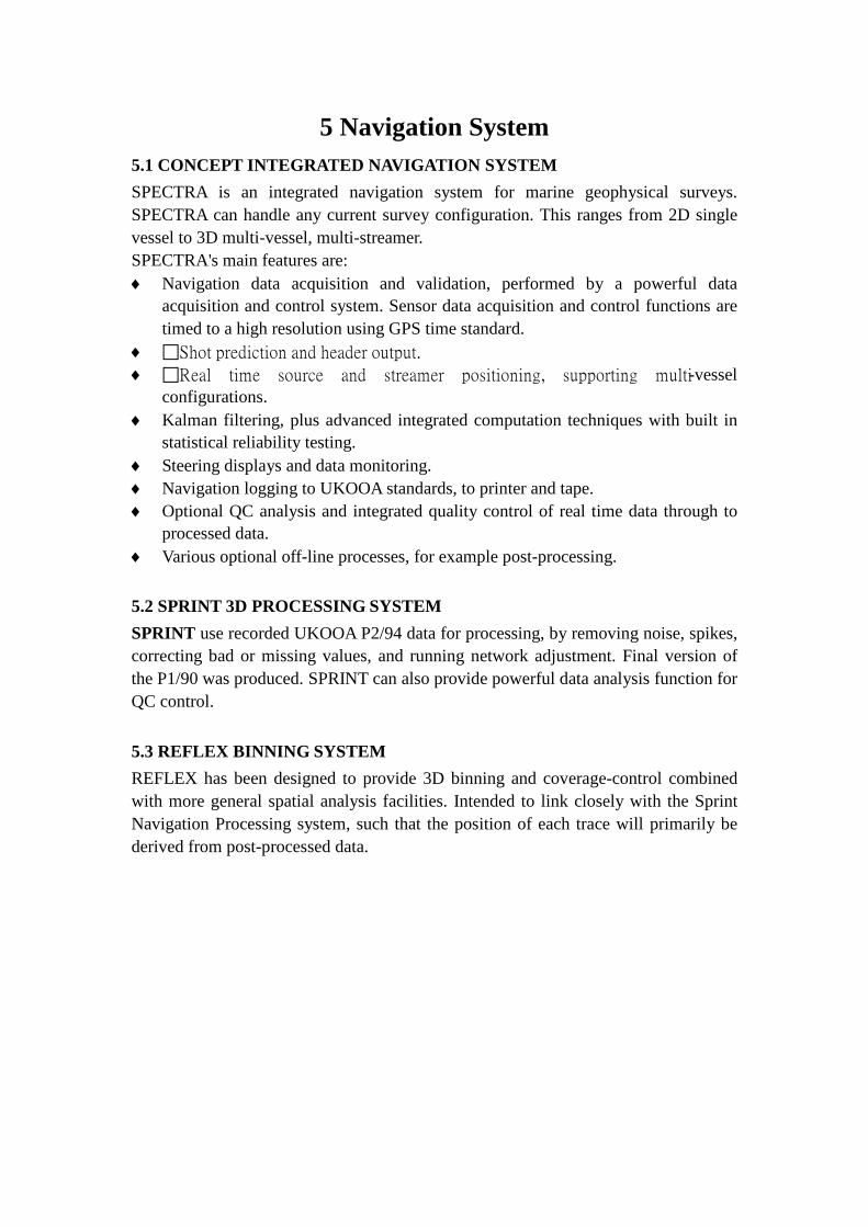
The block diagram provides the interrelationship between Concept system, streamer recording system and gun controller system.
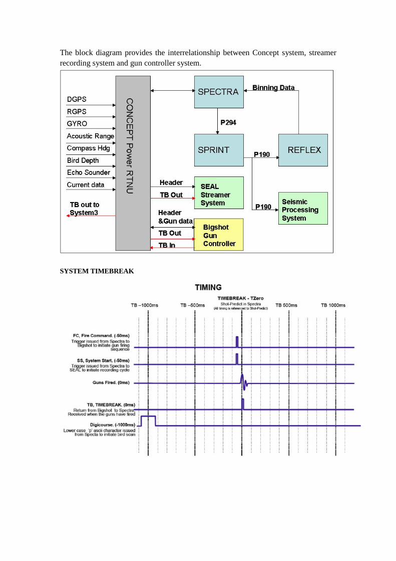
SYSTEM TIMEBREAK
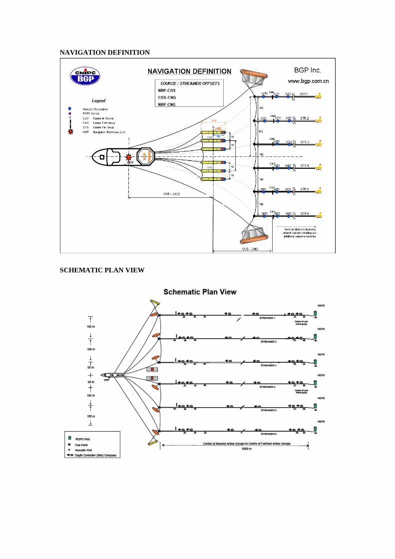
NAVIGATION DEFINITION
SCHEMATIC PLAN VIEW

Navigation and Position configuration Integrated Navigation System Spectra / Concept system Ltd Navigation Quality Control System Spectra DGPS service Veripos / Subsea 7 (changeable as
required) Buoy Positioning RGPS / Seamap Laser System Fanbeam 4 Acoustic Systems System 3 Heading Sensors Digicourse5011E Gyro Compass Navigat x MK1 Processing System Sprint / Concept (on red hat enterprise
Linux) 3D Quality Control System (Binning system) Reflex / Concept
6 Positioning System Details and performance of Vessel Positioning Systems, Primary and Secondary (and Tertiary if applicable)
6.1 DGPS SYSTEM a) Primary positioning system: Veripos Ultra Veripos Ultra offers decimeter level position accuracy globally. The service is based around a positioning technique known as PPP (Precise Point Positioning) where all errors in the GPS system are either independently corrected or modeled to a high degree of accuracy. In contrast to having a unique set of satellite corrections specific to each reference site, Veripos Ultra consists of one set of corrections for the satellites, which are valid globally. These are used at any location with no dependence on distance to reference stations. Veripos Ultra delivers a high accuracy position using a proprietary PPP algorithm developed by Veripos that minimizes or removes all of the main GPS errors sources such as satellite orbit, satellite clock, troposphere, ionosphere and multi-path. Technical specifications: Process type: Precise Point Position (PPP) Observations used: CA & P code + L1 & L2 carrier phase Measurement rate: 0.6 seconds Availability: Worldwide HP satellites: Inmarsat 25E, 98W, 109E LP satellites: Inmarsat AORE, AORW, IOR, POR Data format: Modified RTCM SC104 Type 44 Message types: 44 Transmission rate: 1200 bps Typical data update rate: 30 seconds Normal Horizontal accuracy: 20cm (2DRMS) Normal Vertical accuracy: 30cm (2DRMS) b) Secondary positioning system: Veripos Standard Plus Veripos Standard is a GNSS augmentation Service, designed for high-end GPS users who need reliable, accurate position with a high level of integrity Traditional differential GPS, generically referred to as relative positioning, relies upon reference stations, which derive corrections for each GPS satellite measurement that are then applied at the user end to cancel out common errors. Technical specifications: Process type: Single difference (DGPS) Observations used: CA & P code, L1 & L2 carrier phase Measurement rate: 0.6 seconds
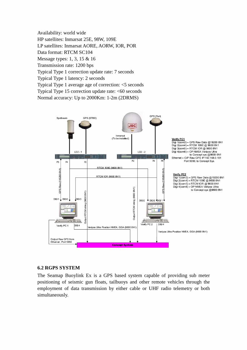
Availability: world wide HP satellites: Inmarsat 25E, 98W, 109E LP satellites: Inmarsat AORE, AORW, IOR, POR Data format: RTCM SC104 Message types: 1, 3, 15 & 16 Transmission rate: 1200 bps Typical Type 1 correction update rate: 7 seconds Typical Type 1 latency: 2 seconds Typical Type 1 average age of correction: <5 seconds Typical Type 15 correction update rate: <60 seconds Normal accuracy: Up to 2000Km: 1-2m (2DRMS)
6.2 RGPS SYSTEM The Seamap Buoylink Ex is a GPS based system capable of providing sub meter positioning of seismic gun floats, tailbuoys and other remote vehicles through the employment of data transmission by either cable or UHF radio telemetry or both simultaneously.
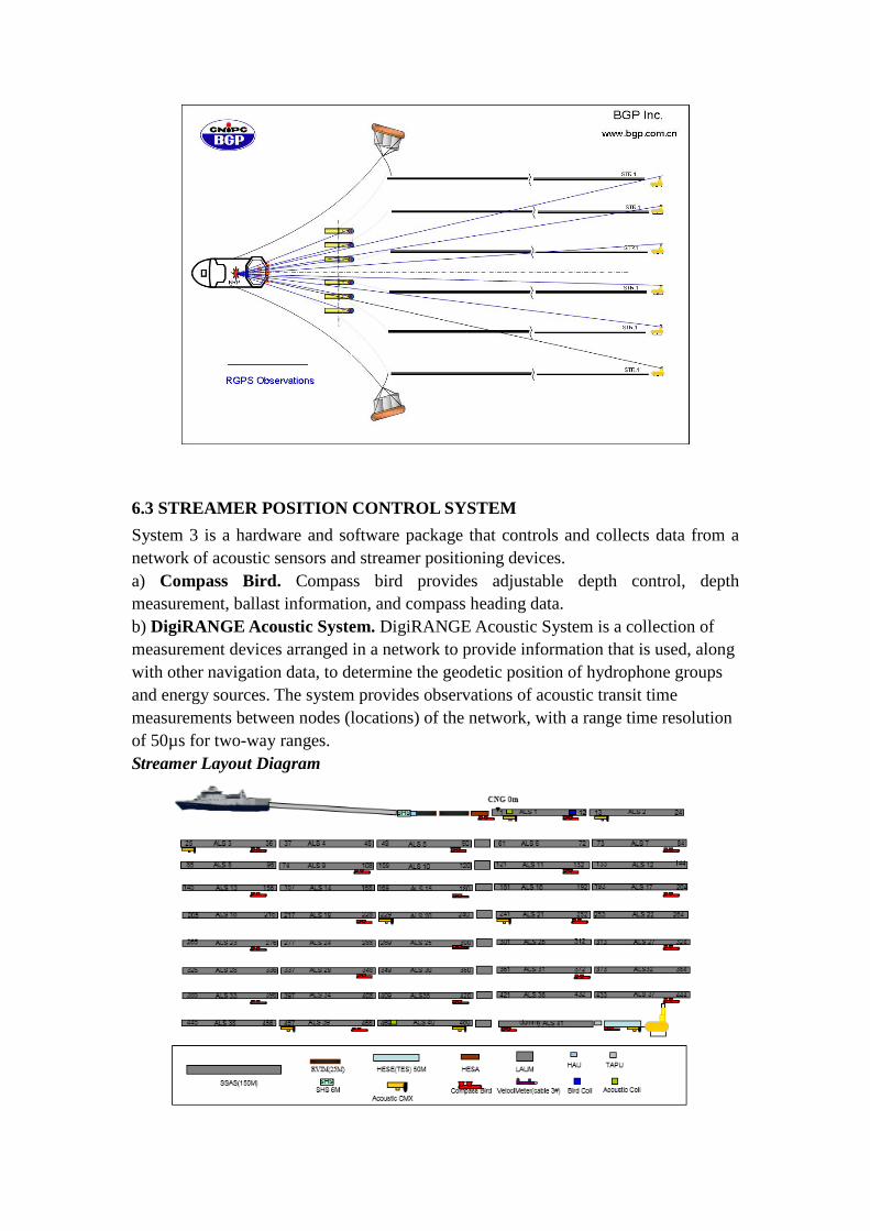
6.3 STREAMER POSITION CONTROL SYSTEM System 3 is a hardware and software package that controls and collects data from a network of acoustic sensors and streamer positioning devices. a) Compass Bird. Compass bird provides adjustable depth control, depth measurement, ballast information, and compass heading data. b) DigiRANGE Acoustic System. DigiRANGE Acoustic System is a collection of measurement devices arranged in a network to provide information that is used, along with other navigation data, to determine the geodetic position of hydrophone groups and energy sources. The system provides observations of acoustic transit time measurements between nodes (locations) of the network, with a range time resolution of 50µs for two-way ranges. Streamer Layout Diagram

Acoustic Networks Diagram
6.4 GYRO COMPASS NAVIGAT MK1 is a microprocessor controlled gyrocompass system with integrated automatic north speed error correction. 6.5 Echo sounder The Kongsberg EA 600 echo sounder is designed for the professional hydrograph community. It can operate with multi-frequency channels simultaneously. 18Khz and 200Khz frequency and used for survey. The maximum detected depth is 500m and 7000m individually.
6.6 STREAMER/SOURCE POSITIONING CABLE LEVELER WITH DEPTH AND COMPASS Type IO DIGICOURSE COMPASS BIRD-5011E Manufacturer Input/Output Inc Streamer communication Induction coil, serial FSK 26 KHz 2400 bit/s Heading sensor Optical Accuracy +/- 0.1° Depth sensor range 0 to 122m Depth sensor type MODEL 483 Depth accuracy +/- 0.1m
ACOUSTIC SYSTEMS Manufacturer I/O Marine System . Inc
Type Serial Fsk
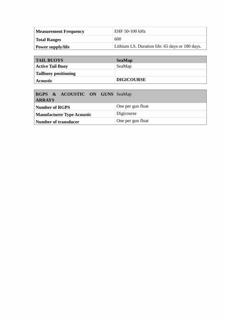
Measurement Frequency EHF 50-100 kHz
Total Ranges 600
Power supply/life Lithium LS. Duration life: 65 days or 180 days. TAIL BUOYS SeaMap Active Tail Buoy SeaMap Tailbuoy positioning
Acoustic DIGICOURSE RGPS & ACOUSTIC ON GUNS ARRAYS
SeaMap
Number of RGPS One per gun float
Manufacturer Type Acoustic Digicourse
Number of transducer One per gun float
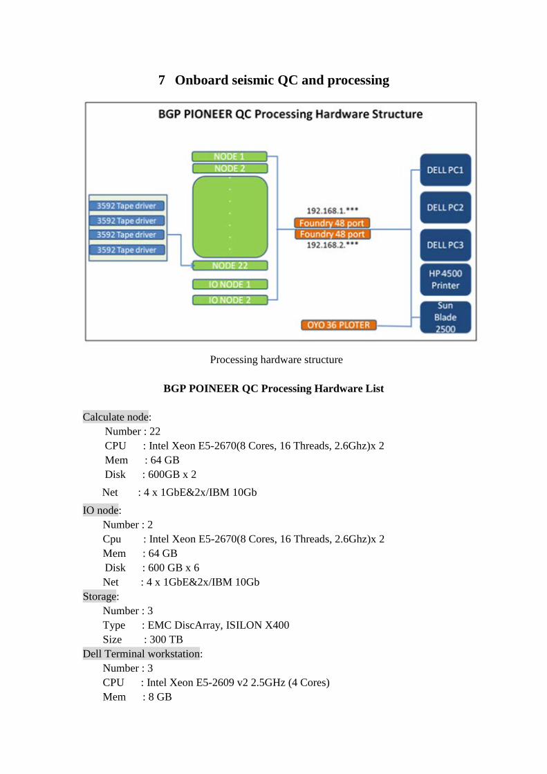
7 Onboard seismic QC and processing
Processing hardware structure
BGP POINEER QC Processing Hardware List
Calculate node:
Number : 22 CPU : Intel Xeon E5-2670(8 Cores, 16 Threads, 2.6Ghz)x 2 Mem : 64 GB Disk : 600GB x 2
Net : 4 x 1GbE&2x/IBM 10Gb IO node:
Number : 2 Cpu : Intel Xeon E5-2670(8 Cores, 16 Threads, 2.6Ghz)x 2 Mem : 64 GB Disk : 600 GB x 6 Net : 4 x 1GbE&2x/IBM 10Gb
Storage: Number : 3 Type : EMC DiscArray, ISILON X400 Size : 300 TB
Dell Terminal workstation: Number : 3 CPU : Intel Xeon E5-2609 v2 2.5GHz (4 Cores) Mem : 8 GB

Disk : 3 TB Net : 1000 Mbps
SUN workstation: Number : 1 Cpu :2 x 3.6Ghz Mem :4GB Disk : 140 GB + 300 GB Net : 1000 Mbps
Net Switch/Management: Number : 2 Type :Extreme Networks Summit X430-48T Speed : 1000 Mbps
Net Switch/Data: Number : 1 Type :Extreme Networks Summit X430-48T-FB
Speed : 10000 Mbps Tape Driver :
2 x 3592 tape driver Plotter : 1 x OYO GS 636-2 inch Plotter, 36 inch Printer : 1 x HP Officejet 4500 SOFTWARE ProMAX Version R5000 GEOEAST Version 2.6.1 OS Linux Version 2.6.18-308.el5